
Research Progress in Spatiotemporal Dynamic Simulation of LUCC

 ,
,
Abstract
:1. Introduction
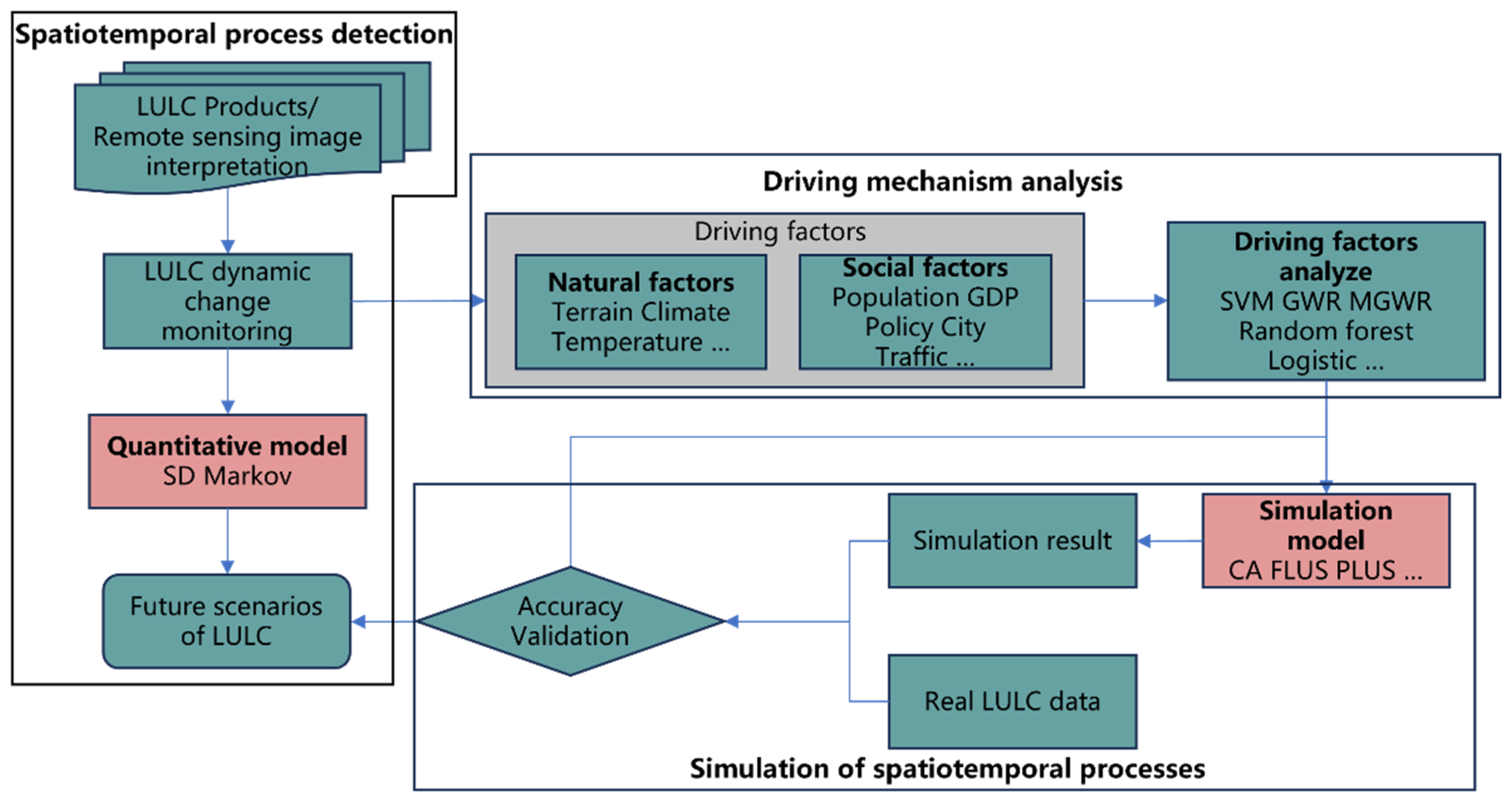
2. Data and Method
3. Research Status of Spatiotemporal Dynamic Simulation of LUCC
3.1. Research Methods for Spatiotemporal Dynamic Simulation of LUCC
3.2. Spatiotemporal Dynamic Simulation Models
3.2.1. Research on the CA Model and Its Extended Models
- (1)
- CA integrated with artificial intelligence (AI).
- (2)
- Integrated models of CA.
3.2.2. Research on the CLUE Model and Its Extended Model
3.2.3. Research on the ABM Model
3.2.4. Research on Land Change Modeler
4. The Main Issues in the Existing Research
4.1. Methodological Issues for Spatiotemporal Dynamic Simulation of LUCC
4.2. Model Issues
4.3. Issues in the Driver Analysis
5. Discussion
5.1. Data Scales and Models
5.2. Challenges and Prospects of Spatiotemporal Dynamic Simulation
6. Conclusions
Author Contributions
Funding
Data Availability Statement
Acknowledgments
Conflicts of Interest
References
- Sun, W.; Liu, Z.; Zhang, Y.; Xu, W.; Lv, X.; Liu, Y.; Lyu, H.; Li, X.; Xiao, J.; Ma, F. Study on land-use changes and their impacts on air pollution in Chengdu. Atmosphere 2020, 11, 42. [Google Scholar] [CrossRef]
- Zhang, Q.; Wu, Z.; Tarolli, P. Investigating the role of green infrastructure on urban waterlogging: Evidence from metropolitan coastal cities. Remote Sens. 2021, 13, 2341. [Google Scholar] [CrossRef]
- Ahmad, A.; Ahmad, S.R.; Gilani, H.; Tariq, A.; Zhao, N.; Aslam, R.W.; Mumtaz, F. A synthesis of spatial forest assessment studies using remote sensing data and techniques in Pakistan. Forests 2021, 12, 1211. [Google Scholar] [CrossRef]
- Kanwal, S.; Ding, X.; Wu, S.; Sajjad, M. Vertical ground displacements and its impact on erosion along the Karachi Coastline, Pakistan. Remote Sen. 2022, 14, 2054. [Google Scholar] [CrossRef]
- Findell, K.L.; Berg, A.; Gentine, P.; Krasting, J.P.; Lintner, B.R.; Malyshev, S.; Santanello, J.A., Jr.; Shevliakova, E. The impact of anthropogenic land use and land cover change on regional climate extremes. Nat. Commun. 2017, 8, 989. [Google Scholar] [CrossRef]
- Hoffmann, P.; Reinhart, V.; Rechid, D.; de Noblet-Ducoudre, N.; Davin, E.L.; Asmus, C.; Bechtel, B.; Böhner, J.; Katragkou, E.; Luyssaert, S. High-resolution land use and land cover dataset for regional climate modelling: Historical and future changes in Europe. Earth Syst. Sci. Data 2023, 15, 3819–3852. [Google Scholar] [CrossRef]
- Molotoks, A.; Smith, P.; Dawson, T.P. Impacts of land use, population, and climate change on global food security. Food Energy Secur. 2021, 10, e261. [Google Scholar] [CrossRef]
- Fujimori, S.; Wu, W.C.; Doelman, J.; Frank, S.; Hristov, J.; Kyle, P.; Sands, R.; Van Zeist, W.J.; Havlik, P.; Domínguez, I.P.; et al. Land-based climate change mitigation measures can affect agricultural markets and food security. Nat. Food 2022, 3, 110–121. [Google Scholar] [CrossRef]
- Allan, J.R.; Possingham, H.P.; Atkinson, S.C.; Waldron, A.; Di Marco, M.; Butchart, S.H.M.; Adams, V.M.; Kissling, W.D.; Worsdell, T.; Sandbrook, C.; et al. The minimum land area requiring conservation attention to safeguard biodiversity. Science 2022, 376, 1094–1101. [Google Scholar] [CrossRef]
- Zhou, G.H.; He, Y.H. The influencing factors of urban land expansion in Changsha. J. Geogr. Sci. 2007, 17, 487–499. [Google Scholar] [CrossRef]
- Zhang, Y.; Liu, Y.; Zhang, Y.; Liu, Y.; Zhang, G.; Chen, Y. On the spatial relationship between ecosystem services and urbanization: A case study in Wuhan, China. Sci. Total Environ. 2018, 637–638, 780–790. [Google Scholar] [CrossRef] [PubMed]
- Meyfroidt, P.; de Bremond, A.; Ryan, C.M.; Archer, E.; Aspinall, R.; Chhabra, A.; Camara, G.; Corbera, E.; DeFries, R.; Diaz, S.; et al. Ten facts about land systems for sustainability. Proc. Natl. Acad. Sci. USA 2022, 119, e2109217118. [Google Scholar] [CrossRef] [PubMed]
- Winkler, K.; Fuchs, R.; Rounsevell, M.; Herold, M. Global land use changes are four times greater than previously estimated. Nat. Commun. 2021, 12, 2501. [Google Scholar] [CrossRef] [PubMed]
- Gao, C.; Feng, Y.J.; Tong, X.H.; Lei, Z.K.; Chen, S.R.; Zhai, S.T. Modeling urban growth using spatially heterogeneous cellular automata models: Comparison of spatial lag, spatial error and GWR. Comput. Environ. Urban Syst. 2020, 81, 101459. [Google Scholar] [CrossRef]
- Wang, H.; Stephenson, S.R.; Qu, S.J. Modeling spatially non-stationary land use/cover change in the lower Connecticut River Basin by combining geographically weighted logistic regression and the CA-Markov model. Int. J. Geogr. Inf. Sci. 2019, 33, 1313–1334. [Google Scholar] [CrossRef]
- Chen, W.X.; Yang, L.Y.; Wu, J.H.; Wu, J.H.; Wang, G.Z.; Bian, J.J.; Zeng, J.; Liu, Z.L. Spatio-temporal characteristics and influencing factors of traditional villages in the Yangtze River Basin: A Geodetector model. Herit. Sci. 2023, 11, 111. [Google Scholar] [CrossRef]
- Ahmad, H.; Abdallah, M.; Jose, F.; Elzain, H.E.; Bhuyan, M.S.; Shoemaker, D.J.; Selvam, S. Evaluation and mapping of predicted future land use changes using hybrid models in a coastal area. Ecol. Inform. 2023, 78, 102324. [Google Scholar] [CrossRef]
- Li, X.; Li, D.; Liu, X.; Lao, C.; Zhang, Y.; He, J.; Huang, K. The Implementation and Application of Geographical Simulation and Optimization Systems (GeoSOS). Zhongshan Daxue Xuebao/Acta Sci. Natralium Univ. Sunyatseni 2010, 49, 1–5+15. [Google Scholar]
- Liang, X.; Guan, Q.F.; Clarke, K.C.; Liu, S.S.; Wang, B.Y.; Yao, Y. Understanding the drivers of sustainable land expansion using a patch-generating land use simulation (PLUS) model: A case study in Wuhan, China. Comput. Environ. Urban Syst. 2021, 85, 101569. [Google Scholar] [CrossRef]
- Liu, X.P.; Liang, X.; Li, X.; Xu, X.C.; Ou, J.P.; Chen, Y.M.; Li, S.Y.; Wang, S.J.; Pei, F.S. A future land use simulation model (FLUS) for simulating multiple land use scenarios by coupling human and natural effects. Landsc. Urban Plan. 2017, 168, 94–116. [Google Scholar] [CrossRef]
- Veldkamp, A.; Fresco, L.O. CLUE: A conceptual model to study the conversion of land use and its effects. Ecol. Model. 1996, 85, 253–270. [Google Scholar] [CrossRef]
- Aburas, M.M.; Ahamad, M.S.S.; Omar, N.Q. Spatio-temporal simulation and prediction of land-use change using conventional and machine learning models: A review. Environ. Monit. Assess. 2019, 191, 205. [Google Scholar] [CrossRef] [PubMed]
- Groeneveld, J.; Müller, B.; Buchmann, C.M.; Dressler, G.; Guo, C.; Hase, N.; Hoffmann, F.; John, F.; Klassert, C.; Lauf, T.; et al. Theoretical foundations of human decision-making in agent-based land use models—A review. Environ. Model. Softw. 2017, 87, 39–48. [Google Scholar] [CrossRef]
- Parker, D.C.; Manson, S.M.; Janssen, M.A.; Hoffmann, M.J.; Deadman, P. Multi-agent systems for the simulation of land-use and land-cover change: A review. Ann. Assoc. Am. Geogr. 2003, 93, 314–337. [Google Scholar] [CrossRef]
- Lambin, E.F.; Geist, H.J.; Lepers, E. Dynamics of land-use and land-cover change in tropical regions. Annu. Rev. Environ. Resour. 2003, 28, 205–241. [Google Scholar] [CrossRef]
- Liu, J.Y.; Deng, X.Z. Progress of the research methodologies on the temporal and spatial process of LUCC. Chin. Sci. Bull. 2010, 55, 1354–1362. [Google Scholar] [CrossRef]
- Allan, A.; Soltani, A.; Abdi, M.H.; Zarei, M. Driving Forces behind Land Use and Land Cover Change: A Systematic and Bibliometric Review. Land 2022, 11, 1222. [Google Scholar] [CrossRef]
- Qiao, Z.; Jiang, Y.; He, T.; Lu, Y.; Xu, X.; Yang, J. Land use change simulation: Progress, challenges, and prospects. Acta Ecol. Sin. 2022, 42, 5165–5176. [Google Scholar]
- Rounsevell, M.D.A.; Pedroli, B.; Erb, K.-H.; Gramberger, M.; Busck, A.G.; Haberl, H.; Kristensen, S.; Kuemmerle, T.; Lavorel, S.; Lindner, M.; et al. Challenges for land system science. Land Use Policy 2012, 29, 899–910. [Google Scholar] [CrossRef]
- Ghosh, S.; Chatterjee, N.D.; Dinda, S. Urban ecological security assessment and forecasting using integrated DEMATEL-ANP and CA-Markov models: A case study on Kolkata Metropolitan Area, India. Sustain. Cities Soc. 2021, 68, 102773. [Google Scholar] [CrossRef]
- Nath, N.; Sahariah, D.; Meraj, G.; Debnath, J.; Kumar, P.; Lahon, D.; Chand, K.; Farooq, M.; Chandan, P.; Singh, S.K.; et al. Land use and land cover change monitoring and prediction of a UNESCO World Heritage Site: Kaziranga Eco-Sensitive Zone using cellular automata-markov model. Land 2023, 12, 151. [Google Scholar] [CrossRef]
- Soares, B.S.; Cerqueira, G.C.; Pennachin, C.L. DINAMICA—A stochastic cellular automata model designed to simulate the landscape dynamics in an Amazonian colonization frontier. Ecol. Model. 2002, 154, 217–235. [Google Scholar] [CrossRef]
- Soares, B.S.; Nepstad, D.C.; Curran, L.M.; Cerqueira, G.C.; Garcia, R.A.; Ramos, C.A.; Voll, E.; McDonald, A.; Lefebvre, P.; Schlesinger, P. Modelling conservation in the Amazon basin. Nature 2006, 440, 520–523. [Google Scholar] [CrossRef] [PubMed]
- Addae, B.; Dragićević, S. Integrating multi-criteria analysis and spherical cellular automata approach for modelling global urban land-use change. Geocarto Int. 2022, 38, 2152498. [Google Scholar] [CrossRef]
- Addae, B.; Dragićević, S. Modelling global urban land-use change process using spherical cellular automata. GeoJournal 2022, 88, 2737–2754. [Google Scholar] [CrossRef]
- Addae, B.; Dragićević, S. Modelling global deforestation using spherical geographic automata approach. ISPRS Int. J. Geo-Inf. 2023, 12, 306. [Google Scholar] [CrossRef]
- Van Asselen, S.; Verburg, P.H. Land cover change or land-use intensification: Simulating land system change with a global-scale land change model. Glob. Change Biol. 2013, 19, 3648–3667. [Google Scholar] [CrossRef]
- Verburg, P.H.; Overmars, K.P. Combining top-down and bottom-up dynamics in land use modeling: Exploring the future of abandoned farmlands in Europe with the Dyna-CLUE model. Landsc. Ecol. 2009, 24, 1167–1181. [Google Scholar] [CrossRef]
- Verburg, P.H.; Soepboer, W.; Veldkamp, A.; Limpiada, R.; Espaldon, V.; Mastura, S.S.A. Modeling the spatial dynamics of regional land use: The CLUE-S model. Environ. Manag. 2002, 30, 391–405. [Google Scholar] [CrossRef]
- Ligtenberg, A.; Bregt, A.K.; van Lammeren, R. Multi-actor-based land use modelling: Spatial planning using agents. Landsc. Urban Plan. 2001, 56, 21–33. [Google Scholar] [CrossRef]
- Anand, J.; Gosain, A.K.; Khosa, R. Prediction of land use changes based on Land Change Modeler and attribution of changes in the water balance of Ganga basin to land use change using the SWAT model. Sci. Total Environ. 2018, 644, 503–519. [Google Scholar] [CrossRef] [PubMed]
- Eastman, J.R.; Toledano, J. A Short Presentation of the Land Change Modeler (LCM). In Geomatic Approaches for Modeling Land Change Scenarios; Camacho Olmedo, M.T., Paegelow, M., Mas, J.-F., Escobar, F., Eds.; Springer International Publishing: Cham, Switzerland, 2018; pp. 499–505. [Google Scholar]
- Gupta, R.; Sharma, L.K. Efficacy of Spatial Land Change Modeler as a forecasting indicator for anthropogenic change dynamics over five decades: A case study of Shoolpaneshwar Wildlife Sanctuary, Gujarat, India. Ecol. Indic. 2020, 112, 106171. [Google Scholar] [CrossRef]
- Fu, F.; Deng, S.; Wu, D.; Liu, W.; Bai, Z. Research on the spatiotemporal evolution of land use landscape pattern in a county area based on CA-Markov model. Sustain. Cities Soc. 2022, 80, 103760. [Google Scholar] [CrossRef]
- Mansour, S.; Al-Belushi, M.; Al-Awadhi, T. Monitoring land use and land cover changes in the mountainous cities of Oman using GIS and CA-Markov modelling techniques. Land Use Policy 2020, 91, 104414. [Google Scholar] [CrossRef]
- Tariq, A.; Shu, H. CA-Markov chain analysis of seasonal land surface temperature and land use land cover change using optical multi-temporal satellite data of Faisalabad, Pakistan. Remote Sen. 2020, 12, 3402. [Google Scholar] [CrossRef]
- da Cunha, E.R.; Guimaraes Santos, C.A.; da Silva, R.M.; Bacani, V.M.; Pott, A. Future scenarios based on a CA-Markov land use and land cover simulation model for a tropical humid basin in the Cerrado/Atlantic forest ecotone of Brazil. Land Use Policy 2021, 101, 105141. [Google Scholar] [CrossRef]
- Halmy, M.W.A.; Gessler, P.E.; Hicke, J.A.; Salem, B.B. Land use/land cover change detection and prediction in the north-western coastal desert of Egypt using Markov-CA. Appl. Geogr. 2015, 63, 101–112. [Google Scholar] [CrossRef]
- Azizi, P.; Soltani, A.; Bagheri, F.; Sharifi, S.; Mikaeili, M. An integrated modelling approach to urban growth and land use/cover change. Land 2022, 11, 1715. [Google Scholar] [CrossRef]
- Henríquez, C.; Pontius, R.G., Jr.; Contreras, P. Performance of CA_Markov and DINAMICA EGO models to evaluate urban risk in Antofagasta and Mejillones, Chile. Nat. Hazards 2024, 120, 8411–8435. [Google Scholar] [CrossRef]
- Rosa, D.W.B.; Das Graças Silva, T.F.; de Araújo, R.P.Z.; de Oliveira Nascimento, N. Hydrological impacts of urban expansion in a Brazilian metropolis—Case study of the Vargem das Flores reservoir catchment. Urban Water J. 2022, 20, 1618–1626. [Google Scholar] [CrossRef]
- Grekousis, G.; Manetos, P.; Photis, Y.N. Modeling urban evolution using neural networks, fuzzy logic and GIS: The case of the Athens metropolitan area. Cities 2013, 30, 193–203. [Google Scholar] [CrossRef]
- Littidej, P.; Uttha, T.; Pumhirunroj, B. Spatial predictive modeling of the burning of Sugarcane Plots in Northeast Thailand with selection of factor sets using a GWR model and machine learning based on an ANN-CA. Symmetry 2022, 14, 1989. [Google Scholar] [CrossRef]
- Zeshan, M.T.; Mustafa, M.R.U.; Baig, M.F. Monitoring land use changes and their future prospects using GIS and ANN-CA for Perak River Basin, Malaysia. Water 2021, 13, 2286. [Google Scholar] [CrossRef]
- Gaur, S.; Mittal, A.; Bandyopadhyay, A.; Holman, I.; Singh, R. Spatio-temporal analysis of land use and land cover change: A systematic model inter-comparison driven by integrated modelling techniques. Int. J. Remote Sens. 2020, 41, 9229–9255. [Google Scholar] [CrossRef]
- Peng, L.; Chen, T.T.; Wang, Q.; Deng, W. Linking ecosystem services to land use decisions: Policy analyses, multi-scenarios, and integrated modelling. ISPRS Int. J. Geo-Inf. 2020, 9, 154. [Google Scholar] [CrossRef]
- Li, X.D.; Zhang, M.X.; Zhang, S.Y.; Liu, J.Q.; Sun, S.F.; Hu, T.X.; Sun, L. Simulating forest fire spread with cellular automation driven by a LSTM based speed model. Fire 2022, 5, 13. [Google Scholar] [CrossRef]
- Liu, L.; Sun, X.K. Volcanic ash cloud diffusion from remote sensing image using LSTM-CA method. IEEE Access 2020, 8, 54681–54690. [Google Scholar] [CrossRef]
- Almeida, C.M.; Gleriani, J.M.; Castejon, E.F.; Soares, B.S. Using neural networks and cellular automata for modelling intra-urban land-use dynamics. Int. J. Geogr. Inf. Sci. 2008, 22, 943–963. [Google Scholar] [CrossRef]
- Huang, Z.H.; Du, H.Q.; Li, X.J.; Zhang, M.; Mao, F.J.; Zhu, D.E.; He, S.B.; Liu, H. Spatiotemporal LUCC simulation under different RCP scenarios based on the BPNN_CA_Markov model: A case study of bamboo forest in Anji County. ISPRS Int. J. Geo-Inf. 2020, 9, 718. [Google Scholar] [CrossRef]
- Rifat, S.A.A.; Liu, W. Predicting future urban growth scenarios and potential urban flood exposure using Artificial Neural Network-Markov Chain model in Miami Metropolitan Area. Land Use Policy 2022, 114, 105994. [Google Scholar] [CrossRef]
- Tajbakhsh, A.; Karimi, A.; Zhang, A.L. Modeling land cover change dynamic using a hybrid model approach in Qeshm Island, Southern Iran. Environ. Monit. Assess. 2020, 192, 303. [Google Scholar] [CrossRef] [PubMed]
- Liu, C.L.; Xia, J.X. Dynamic simulation of land use based on the LSTM-CA model. Remote Sencing Nat. Resour. 2022, 34, 122–128. [Google Scholar]
- Chen, G.Z.; Zhuang, H.M.; Liu, X.P. Cell-level coupling of a mechanistic model to cellular automata for improving land simulation. GIScience Remote Sens. 2023, 60, 2166443. [Google Scholar] [CrossRef]
- Liu, Q.; Yang, D.D.; Cao, L.; Anderson, B. Assessment and prediction of carbon storage based on land use/land cover dynamics in the tropics: A case study of Hainan Island, China. Land 2022, 11, 244. [Google Scholar] [CrossRef]
- Xu, L.; Liu, X.; Tong, D.; Liu, Z.; Yin, L.; Zheng, W. Forecasting urban land use change based on cellular automata and the PLUS model. Land 2022, 11, 652. [Google Scholar] [CrossRef]
- Sun, F.H.; Fang, F.M.; Hong, W.L.; Luo, H.; Fang, L.; Miao, Y.Q. Evolution analysis and prediction of carbon storage in Anhui Province based on PLUS and InVEST model. J. Soil Water Conserv. 2023, 37, 151–158. [Google Scholar] [CrossRef]
- Addae, B.; Dragićević, S. Enabling geosimulations for global scale: Spherical geographic automata. Trans. GIS 2023, 27, 821–840. [Google Scholar] [CrossRef]
- Wang, Q.R.; Liu, R.M.; Men, C.; Guo, L.J. Application of genetic algorithm to land use optimization for non-point source pollution control based on CLUE-S and SWAT. J. Hydrol. 2018, 560, 86–96. [Google Scholar] [CrossRef]
- Loukika, K.N.; Keesara, V.R.; Buri, E.S.; Sridhar, V. Future prediction of scenario based land use land cover (LU&LC) using DynaCLUE model for a river basin. Ecol. Inform. 2023, 77, 102223. [Google Scholar] [CrossRef]
- Li, S.; Liu, X.; Li, X.; Chen, Y. Simulation model of land use dynamics and application: Progress and prospects. Natl. Remote Sens. Bull. 2017, 21, 329–340. [Google Scholar] [CrossRef]
- Hosseinali, F.; Alesheikh, A.A.; Nourian, F. Assessing urban land-use development: Developing an agent-based model. KSCE J. Civ. Eng. 2015, 19, 285–295. [Google Scholar] [CrossRef]
- Mirzahossein, H.; Noferesti, V.; Jin, X. Residential development simulation based on learning by agent-based model. Tema J. Land Use Mobil. Environ. 2022, 15, 193–207. [Google Scholar] [CrossRef]
- Li, F.X.; Xie, Z.K.; Clarke, K.C.; Li, M.C.; Chen, H.H.; Liang, J.; Chen, Z.J. An agent-based procedure with an embedded agent learning model for residential land growth simulation: The case study of Nanjing, China. Cities 2019, 88, 155–165. [Google Scholar] [CrossRef]
- Gao, J.B.; Cai, Y.L. Paradigm shift in the study of land use/cover change. China Popul. Resour. Environ. 2011, 21, 114–120. [Google Scholar]
- Kraff, N.J.; Wurm, M.; Taubenböck, H. Uncertainties of human perception in visual image interpretation in complex urban environments. IEEE J. Sel. Top. Appl. Earth Obs. Remote Sens. 2020, 13, 4229–4241. [Google Scholar] [CrossRef]
- Luyssaert, S.; Jammet, M.; Stoy, P.C.; Estel, S.; Pongratz, J.; Ceschia, E.; Churkina, G.; Don, A.; Erb, K.; Ferlicoq, M.; et al. Land management and land-cover change have impacts of similar magnitude on surface temperature. Nat. Clim. Change 2014, 4, 389–393. [Google Scholar] [CrossRef]
- He, Y.B.; Yao, Y.M.; Tang, H.J.; Chen, Y.Q.; Chen, Z.X.; Yang, P.; Yu, S.K. An overview on progress of land use and land cover change dynamics. Chin. Agric. Sci. Bull. 2013, 29, 190–195. [Google Scholar]
- Long, H. Land use transition and land management. Geogr. Res. 2015, 34, 1607–1618. [Google Scholar]
- Meng, J.; Zhu, L.; Wang, Q.; Guo, L.; Zhang, W. Influence of policy-driven land use transformation on multifunctional land use in the middle reaches of the Heihe river basin. Acta Sci. Nat. Univ. Pekin. 2020, 56, 1102–1112. [Google Scholar] [CrossRef]
- Sari, F. Assessment of land-use change effects on future beekeeping suitability vis Ca-Markov prediction model. J. Apic. Sci. 2020, 64, 263–276. [Google Scholar] [CrossRef]
- Liu, J. Study on the Expansion and Simulation of Urban Land in Chongqing Liangjiang New Area. Master’s Thesis, Southwestern University, Chongqing, China, 2019. [Google Scholar]
- Zhao, Y.H.; Liu, X.J. Land cover change and its social driving forces in the upper Min River basin, China. Desalination Water Treat. 2014, 52, 2771–2777. [Google Scholar] [CrossRef]
- Zhang, Y.; Cao, B.; Zhang, Q.Y.; Cui, S.F.; Cui, B.S.; Du, J.Z. Responses of urban wetland to climate change and human activities in Beijing: A case study of Hanshiqiao Wetland. Sustainability 2022, 14, 4530. [Google Scholar] [CrossRef]
- Feng, Y.J.; Tong, X.H. Dynamic land use change simulation using cellular automata with spatially nonstationary transition rules. GIScience Remote Sens. 2018, 55, 678–698. [Google Scholar] [CrossRef]
- Zhang, S.; Zhong, Q.; Cheng, D.; Xu, C.; Chang, Y.; Lin, Y.; Li, B. Landscape ecological risk projection based on the PLUS model under the localized shared socioeconomic pathways in the Fujian Delta region. Ecol. Indic. 2022, 136, 108642. [Google Scholar] [CrossRef]
- Wang, Y. Research on Land Use Change Predicition Based on Improved CLUE-S Model and Landscape Pattern Analysis -Take Changle District of Fujian Province as an example. Master’s Thesis, China University of Geosciences, Beijing, China, 2022. [Google Scholar]
- Geist, H.J.; Lambin, E.F. Dynamic causal patterns of desertification. BioScience 2004, 54, 817–829. [Google Scholar] [CrossRef]
- Plieninger, T.; Draux, H.; Fagerholm, N.; Bieling, C.; Burgi, M.; Kizos, T.; Kuemmerle, T.; Primdahl, J.; Verburg, P.H. The driving forces of landscape change in Europe: A systematic review of the evidence. Land Use Policy 2016, 57, 204–214. [Google Scholar] [CrossRef]
- Santana-Cordero, A.M.; Burgi, M.; Hersperger, A.M.; Hernandez-Calvento, L.; Monteiro-Quintana, M.L. A century of change in coastal sedimentary landscapes in the Canary Islands (Spain)—Change, processes, and driving forces. Land Use Policy 2017, 68, 107–116. [Google Scholar] [CrossRef]
- Yang, M.; Zhang, B.L.; Hou, Y.P. Advances and Prospects of the Driving Force of Regional Land Use Change Researches. Geogr. Geo-Inf. Sci. 2011, 27, 95–100. [Google Scholar]
- Anh Nguyet, D.; Kawasaki, A. Integrating biophysical and socio-economic factors for land-use and land-cover change projection in agricultural economic regions. Ecol. Model. 2017, 344, 29–37. [Google Scholar] [CrossRef]
- Zhou, Y.; Li, X.; Liu, Y. Land use change and driving factors in rural China during the period 1995–2015. Land Use Policy 2020, 99, 105048. [Google Scholar] [CrossRef]
- Pal, S.; Ziaul, S. Detection of land use and land cover change and land surface temperature in English Bazar urban centre. Egypt. J. Remote Sens. Space Sci. 2017, 20, 125–145. [Google Scholar] [CrossRef]
- Yadava, A.K.; Bräuning, A.; Singh, J.; Yadav, R.R. Boreal spring precipitation variability in the cold arid western Himalaya during the last millennium, regional linkages, and socio-economic implications. Quat. Sci. Rev. 2016, 144, 28–43. [Google Scholar] [CrossRef]
- Tariq, A.; Mumtaz, F.; Majeed, M.; Zeng, X. Spatio-temporal assessment of land use land cover based on trajectories and cellular automata Markov modelling and its impact on land surface temperature of Lahore district Pakistan. Environ. Monit. Assess. 2022, 195, 114. [Google Scholar] [CrossRef] [PubMed]
- Li, L.; Huang, X.J.; Wu, D.F.; Yang, H. Construction of ecological security pattern adapting to future land use change in Pearl River Delta, China. Appl. Geogr. 2023, 154, 102946. [Google Scholar] [CrossRef]
- Wu, X.; Wang, S.; Fu, B.; Liu, Y.; Zhu, Y. Land use optimization based on ecosystem service assessment: A case study in the Yanhe watershed. Land Use Policy 2018, 72, 303–312. [Google Scholar] [CrossRef]
- Estacio, I.; Sianipar, C.P.M.; Onitsuka, K.; Basu, M.; Hoshino, S. A statistical model of land use/cover change integrating logistic and linear models: An application to agricultural abandonment. Int. J. Appl. Earth Obs. Geoinf. 2023, 120, 103339. [Google Scholar] [CrossRef]
- Lukas, P.; Melesse, A.M.; Kenea, T.T. Prediction of future land use/land cover changes using a coupled CA-ANN model in the upper Omo-Gibe River Basin, Ethiopia. Remote Sen. 2023, 15, 1148. [Google Scholar] [CrossRef]
- Tariq, A.; Mumtaz, F. A series of spatio-temporal analyses and predicting modeling of land use and land cover changes using an integrated Markov chain and cellular automata models. Environ. Sci. Pollut. Res. 2023, 30, 47470–47484. [Google Scholar] [CrossRef]
- Sun, S.T.; Mu, L.; Feng, R.Y.; Wang, L.Z.; He, J.J. GAN-Based LUCC prediction via the combination of prior city planning information and land-use probability. IEEE J. Sel. Top. Appl. Earth Obs. Remote Sens. 2021, 14, 10189–10198. [Google Scholar] [CrossRef]
- Wang, H.C.; Fu, T.F.; Du, Y.Q.; Gao, W.H.; Huang, K.X.; Liu, Z.M.; Chandak, P.; Liu, S.C.; Van Katwyk, P.; Deac, A.; et al. Scientific discovery in the age of artificial intelligence. Nature 2023, 620, 47–60. [Google Scholar] [CrossRef]
- Brown, D.G.; Verburg, P.H.; Pontius, R.G., Jr.; Lange, M.D. Opportunities to improve impact, integration, and evaluation of land change models. Curr. Opin. Environ. Sustain. 2013, 5, 452–457. [Google Scholar] [CrossRef]
- Li, Y.G.; Liu, W.; Feng, Q.; Zhu, M.; Yang, L.S.; Zhang, J.T.; Yin, X.W. The role of land use change in affecting ecosystem services and the ecological security pattern of the Hexi Regions, Northwest China. Sci. Total Environ. 2023, 855, 158940. [Google Scholar] [CrossRef] [PubMed]
- Simkin, R.D.; Seto, K.C.; McDonald, R.I.; Jetz, W. Biodiversity impacts and conservation implications of urban land expansion projected to 2050. Proc. Natl. Acad. Sci. USA 2022, 119, e2117297119. [Google Scholar] [CrossRef] [PubMed]
- Gong, J.; Cao, E.J.; Xie, Y.C.; Xu, C.X.; Li, H.Y.; Yan, L.L. Integrating ecosystem services and landscape ecological risk into adaptive management: Insights from a western mountain-basin area, China. J. Environ. Manag. 2021, 281, 111817. [Google Scholar] [CrossRef] [PubMed]
- Xu, W.X.; Wang, J.M.; Zhang, M.; Li, S.J. Construction of landscape ecological network based on landscape ecological risk assessment in a large-scale opencast coal mine area. J. Clean. Prod. 2021, 286, 125523. [Google Scholar] [CrossRef]
- Xue, L.Q.; Zhu, B.L.; Wu, Y.P.; Wei, G.H.; Liao, S.M.; Yang, C.B.; Wang, J.; Zhang, H.; Ren, L.; Han, Q. Dynamic projection of ecological risk in the Manas River basin based on terrain gradients. Sci. Total Environ. 2019, 653, 283–293. [Google Scholar] [CrossRef]
- Gao, L.A.; Tao, F.; Liu, R.R.; Wang, Z.L.; Leng, H.J.; Zhou, T. Multi-scenario simulation and ecological risk analysis of land use based on the PLUS model: A case study of Nanjing. Sustain. Cities Soc. 2022, 85, 104055. [Google Scholar] [CrossRef]
- Domingo, D.; Palka, G.; Hersperger, A.M. Effect of zoning plans on urban land-use change: A multi-scenario simulation for supporting sustainable urban growth. Sustain. Cities Soc. 2021, 69, 102833. [Google Scholar] [CrossRef]
- Li, L.; Huang, X.; Yang, H. Scenario-based urban growth simulation by incorporating ecological-agricultural-urban suitability into a Future Land Use Simulation model. Cities 2023, 137, 104334. [Google Scholar] [CrossRef]
- Mustafa, A.; Ebaid, A.; Omrani, H.; McPhearson, T. A multi-objective markov chain Monte Carlo cellular automata model: Simulating multi-density urban expansion in NYC. Comput. Environ. Urban Syst. 2021, 87, 101602. [Google Scholar] [CrossRef]


| Models | Characteristics | Main Limitations |
|---|---|---|
| Cellular Automaton [30,31] | Changes cell states through local simple rules, generating macro-level LUCC results from the bottom up. | Transformation rules rely on empirical statistics or expert knowledge; challenges in incorporating social factors. |
| Dinamica EGO [32,33] | The variables in the model undergo changes as the model runs deeper. | Transformation rules rely on empirical statistics or expert knowledge. |
| FLUS Model [20] | Introduces adaptive inertia coefficients and a roulette competition mechanism to determine the final land use type. | Difficult to clearly reflect spatial differences in LUCC on different locations. |
| GeoSOS Model [18] | A comprehensive analysis platform that integrates CA, multi-agent, and bio-intelligence. | Limited in identifying non-linear transformation rules and spatial variability of conversion rules. |
| PLUS Model [19] | Combines the advantages of transition analysis and pattern analysis, proposing an approach that integrates CA model with patch generation simulation strategy. | Land use development is influenced by policies and future planning. |
| Spherical geographic automata [34,35,36] | The spatiotemporal dynamic simulation model at the global scale adopts regular hexagonal cells and Earth surface curvature to avoid spatial distortions caused by Earth projection. | The accessibility of data is constrained, and spatial scale is limited. Furthermore, as data spatial resolution increases, data volume grows, and modeling system complexity rises, higher-performance computers are required. |
| CLUE-S Model [21,37,38,39] | Enables spatial configuration of systematic LULC types. | Non-spatial modules require calculations with independent mathematical models; neglects the possibility of non-dominant land class conversions. |
| Agent-Based Model [40] | Simulates decisions and behaviors of heterogeneous agents, explaining the role of agents in LUCC. | Rules are defined based on case-specific situations, lacking universality; challenging to represent spatial behaviors of agents. |
| Land Change Modeler [41,42,43] | Simplifies the analysis process, and provides three methods to generate LULC transition probability maps; it can be integrated with biodiversity and greenhouse gas emission assessments. | The relationship between current LULC and explanatory factors was considered without taking into account the pattern of LULC during the calibration period. |
| SLEUTH Model [28] | Corrects different parameter combinations to achieve suitable results, replacing historical data, simulating LUCC. | Limited consideration of socioeconomic factors. |
| Method | Features |
|---|---|
| Principal Component Analysis (PCA) [81] | Facilitates a more understandable and usable outcome of the dataset. |
| Partial Least Squares Regression (PLSR) [82] | Suitable for complex samples and situations with multiple variable correlations. |
| Geographically Weighted Regression (GWR) [14] | Explores spatial variations and related driving factors at a specific scale. |
| Logistic Regression (LR) [17] | Highly efficient, requires minimal computational resources, and offers calibrated prediction probabilities without feature scaling. |
| Analytic Hierarchy Process (AHP) [83] | Treats the research object as a system, making decisions through decomposition, comparison, judgment, and synthesis. |
| Grey Relational Analysis [84] | Applicable to varied sample sizes and irregular patterns, regardless of whether the samples exhibit regularities. |
| Type | Driving Factor | Examples |
|---|---|---|
| Natural Factors | Topography | Elevation, Slope, Aspect, etc. |
| Climate | Temperature, Growing Degree Days, Precipitation, Sunshine, Wind, etc. | |
| Soil Properties | Soil pH, Soil Salinity, Soil Organic Matter, Soil Thickness, etc. | |
| Human Factors | Development | GDP, Technological Development, etc. |
| Population | Population Distribution, Age Structure, Education Level, etc. | |
| Locational Conditions | Urban Centers, Roads, Rivers, Transportation Facilities, etc. | |
| Institutions, Policies | Government Reports, National and International Ecosystem-related Plans |
Disclaimer/Publisher’s Note: The statements, opinions and data contained in all publications are solely those of the individual author(s) and contributor(s) and not of MDPI and/or the editor(s). MDPI and/or the editor(s) disclaim responsibility for any injury to people or property resulting from any ideas, methods, instructions or products referred to in the content. |
© 2024 by the authors. Licensee MDPI, Basel, Switzerland. This article is an open access article distributed under the terms and conditions of the Creative Commons Attribution (CC BY) license (https://creativecommons.org/licenses/by/4.0/).
Share and Cite
Wan, W.; Tian, Y.; Tian, J.; Yuan, C.; Cao, Y.; Liu, K. Research Progress in Spatiotemporal Dynamic Simulation of LUCC. Sustainability 2024, 16, 8135. https://doi.org/10.3390/su16188135
Wan W, Tian Y, Tian J, Yuan C, Cao Y, Liu K. Research Progress in Spatiotemporal Dynamic Simulation of LUCC. Sustainability. 2024; 16(18):8135. https://doi.org/10.3390/su16188135
Chicago/Turabian StyleWan, Wenhao, Yongzhong Tian, Jinglian Tian, Chengxi Yuan, Yan Cao, and Kangning Liu. 2024. "Research Progress in Spatiotemporal Dynamic Simulation of LUCC" Sustainability 16, no. 18: 8135. https://doi.org/10.3390/su16188135
APA StyleWan, W., Tian, Y., Tian, J., Yuan, C., Cao, Y., & Liu, K. (2024). Research Progress in Spatiotemporal Dynamic Simulation of LUCC. Sustainability, 16(18), 8135. https://doi.org/10.3390/su16188135