Article

Construction of Karst Landscape Ecological Security Pattern Based on Conflict between Human and Nature in Puzhehei

College of Landscape Architecture and Horticulture Science, Southwest Forestry University, Kunming 650224, China
*
Authors to whom correspondence should be addressed.
Sustainability 2024, 16(2), 908; https://doi.org/10.3390/su16020908
Submission received: 24 October 2023 / Revised: 16 January 2024 / Accepted: 18 January 2024 / Published: 21 January 2024

Abstract

:
A key means of promoting the high-quality development of karst areas is the maintenance of the area’s ecological security. A full recognition of the special ecological function of karst areas, as well as their significance to the surrounding region’s ecological, economic, and social development, is crucial in strengthening the overall strategic deployment of the national ecological construction and the protection and sustainable development of karst landscapes around the globe. In this study, the karst landscape of Puzhehei, Qiubei County, Wenshan Prefecture, Yunnan Province, China, was used as the research object. This study identified ecological source sites through a combination of morphological spatial pattern analysis and landscape connectivity assessment. As a result, 10 factors were selected to construct a comprehensive ecological resistance surface from the natural environment and socio-economic perspective; the resistance surface was corrected by combining the sensitivity of rocky desertification. An ecological corridor and ecological nodes were identified to construct the ecological security pattern based on the minimum cumulative resistance model and circuit theory. The results show that (1) the source areas of the Puzhehei karst landscape ecological protection comprised 11 core area patches with the landscape connectivity index of (dPC) ≥ 10, with a total area of 166.6572 km2, which constituted 46.06% of the total study area, and the ecological source area totaled 77.275 km2, or 21.36% of the total study area; (2) there were 78 potential ecological corridors in the Puzhehei karst region, with a total length of 545.186 km, including 12 key corridors and 66 general corridors; (3) a total of 51 ecological nodes were identified, including 11 “source-type ecological nodes”, 30 “ecological pinch points”, and 10 “ecological obstacles”, including 16 key ecological nodes. This study provides a theoretical basis for the integration of Puzhehei Nature Reserve, as well as a reference for the ecologically sustainable development of similar karst areas.

1. Introduction

Human interactions with nature contribute to various social–ecological systems and have far-reaching implications for sustainability across time and space. Currently, human drivers have dramatically altered the natural conditions in most parts of the globe, and high-intensity human activities have exerted greater pressure on the self-regulation and restoration of the natural environment. Thus, human actions and interactions have become the main driving force in changing and reshaping the spatial pattern of national territories. Over the years, the Chinese government has made efforts to build an ecological civilization system, and, as a result, the ecological security system, focusing on the virtuous cycle of ecosystems and the effective prevention and control of environmental risks, has been continuously improved. The 15th Conference of the Parties to the Convention on Biological Diversity (CBD COP15) was held in Yunnan, China, in October 2021. Yunnan Province has been principally focusing on becoming a frontrunner in building an ecological civilization and constructing a national ecological security barrier in the southwest of the country, so as to build a firm foundation for ecological environmental protection. In Puzhehei, located in Qiubei County, Wenshan Prefecture, Yunnan Province, China, the karst landforms are extensively represented in the landscape and exhibit comprehensive development. The formation of an extensive array of lakes and wetlands amidst the peak forests, i.e., peaks, is particularly noteworthy, and forms a phenomenon that is exceptionally rare within the core area of China’s Karst Heritage Site and other karst regions worldwide. Therefore, this unique feature has earned the area the designation of “Wonders of China’s Karst Landscapes”.
The area contains the Puzhehei National Scenic Area, Puzhehei Provincial Nature Reserve, and Puzhehei National Wetland Park, which is extremely rich in biodiversity and is the metropolis of wetland biodiversity in China’s karst region. After many investigations, in terms of plant resources, the following have been identified: Ottelia acuminata, Trapa incisa, Neocheiropteris palmatopedata, and other rare and endangered plants under the protection of the State Class II; furthermore, in recent years, Nelumbo nucifera and other rare wild lotuses have been found in succession. As for animal resources, Triplophysa qiubeiensis, Sinocyclocheilus qiubeiensis, and Sinocyclocheilus aquihornes are all endemic to the Puzhehei Karst region. In addition, there are Ciconia boyciana, Aquila chrysaetos, and other national-level key protected animals, and in terms of national second-level key protected animals there are Elanus caeruleus, Accipiter nisus, and Accipiter virgatus. These precious species resources all highlight the uniqueness and diversity of Puzhehei, and it is of great importance to study and protect them. Furthermore, the Yi, Zhuang, Miao, and other ethnic minority groups have contributed to the development of a unique karst water town culture and distinct tourism resources in southeastern Yunnan. As the sole designated “Tourism Circular Economy Pilot Zone” in Yunnan Province, it holds considerable international influence. The conflict between humans and nature is a significant contradiction in this area, which ultimately represents a contradiction between protection and development.
As an ecologically sensitive area, the karst region has a more complex geology and displays a variety of geomorphologic types. From the research object’s perspective, previous studies have primarily concentrated on constructing ecological security patterns based on the vernacular culture [1], urban landscapes [2], and biodiversity protection [3]. This is mainly due to the vulnerability and sensitivity of karst landscapes, which makes them complex and subjective to study. In terms of study areas, scholars, such as Malá Jitka, Čech Vladimír, Arantza Aranburu, Alexandrowicz Stefan Witold, Howard Limbert, Romeo Eftimi, and others, have explored karst landscapes in the Czech Republic [4], Slovakia [5], Florida [6], Northern Iberia [7], Poland [8], Vietnam [9], and Albania [10]. China is rich in karst landscape and rocky desertification resources, but its research needs to be further deepened, especially in the Yunnan–Guizhou–Sichuan karst area represented by Yunnan Province. In terms of research approaches, Tian Shu [11] studied the relationship between a karst landscape and spatial and temporal changes in land use, but did not provide insight into the underlying mechanisms of the interactions, and further studies are needed to characterize their relevance; Shuai N [12] constructed and optimized the ecological network of a karst area based on multi-scale nesting in Hechi City, Guangxi; the study can alleviate the contradiction between ecological security and economic development to a certain extent, but with the ever-changing material needs of human society, there are obvious uncertainty about the future benefits of ecological protection and restoration. Ying B [13] identified landscape security patterns based on ecosystem services and ecological sensitivity using the karst rocky desertification area as the example, but this study mainly used the minimum cost distance to identify corridors and did not explore in detail the effect of corridor width on landscape ecological functions. Overall, despite the present series of achievements in the research and protection of karst landscapes, relevant scholars have yet to study the construction of security patterns in karst landscapes. Therefore, it is necessary to construct a multi-scale and multi-directional network structure to further explore the intrinsic mechanisms of karst landscapes as well as the relationship between humans and nature, in order to make the landscape planning process more rational.
Constructing ecological security patterns from the landscape ecology perspective has emerged as a viable approach to achieving harmonious development between humans and nature. The “Source Identification-Resistance Surface Construction-Corridor Extraction” models have evolved into the cornerstones of frameworks for analyzing ecological security patterns. In terms of identifying ecological source areas, numerous studies have employed ecosystem service value assessment [14], evaluation of the importance of ecosystem service functions [15], and evaluation of landscape ecological sensitivity [16], and this study combined morphological spatial pattern analysis [17] and evaluation of landscape connectivity [18] to maximize the selection of habitats suitable for migratory movements of species, taking into account the spatial pattern and functional attributes of ecological patches. The resistance surface is primarily established through landscape resistance assessment and a comprehensive evaluation system [19]. Additionally, night-time light data [20] have been utilized to modify resistance factors within the present study area. Whereas these research methods are mainly applicable to urban areas, for sensitive landscapes, such as karsts, rocky desertification needs to be further taken into account, and in this paper, the resistance surface has been modified by incorporating rocky desertification sensitivity factors. Typically, corridor construction is guided by the minimum cumulative resistance (MCR) model [21] and circuit theory [22], while the gravity model [23] is used to identify significant ecological corridors. In this paper, the minimum cumulative resistance model and circuit theory were combined, which can maximize the coverage and connectivity of regional ecological security patterns and effectively avoid the subjectivity of a single approach. In the case of ecological nodes, ArcGIS 10.5 spatial analysis software is commonly employed to determine the points where resistance “ridge lines” intersect with ecological corridors, as well as the intersections of resistance “ridge lines” with “valley lines” and ecological corridors with other ecological corridors, to ensure the functional attributes and spatial structure of the extracted ecological nodes with a view to utilizing the ecological benefits of the area.
The geological structure of the Puzhehei Karst Plateau’s lakes and wetlands is relatively special, and plays an important ecological service function in the maintenance of the hydrological cycle of the karst area, supply of water resources in the region, protection of biodiversity of the karst area, and the security of the Pearl River Basin. This study focuses on the Puzhehei karst landscape and employs Morphological Spatial Pattern Analysis (MSPA) and landscape connectivity evaluation to identify ecological sources. Additionally, the hierarchical analysis process (AHP) and Delphi methods were used to build a resistant surface by thoroughly evaluating the natural environment and human society. The ecological resistance surface was corrected by taking into account the impact of karst landscape characteristics and regional variations in resistance in order to create an ecological source region with comprehensive ecological value. The minimum cumulative resistance (MCR), circuit theory, and the gravity model were used to identify crucial and general ecological corridors. The circuit theory-based identification of “source type ecological nodes”, “ecological pinch points”, and “barrier points” served as ecological nodes. As a result, an ecological security pattern was established. This study provides a theoretical basis for the integration of Puzhehei Nature Reserve, as well as a reference for the ecological sustainable development of similar karst areas. The construction and development of the Puzhehei wetland should be prioritized to form an international business card in China’s relationship with the world, possessing the obvious characteristics of a karst wetland with multiple functionalities and multiple benefits, maintaining the ecological safety of the Puzhehei River wetland region and developing sustainable practices in the local economy and society.

2. Materials and Methods
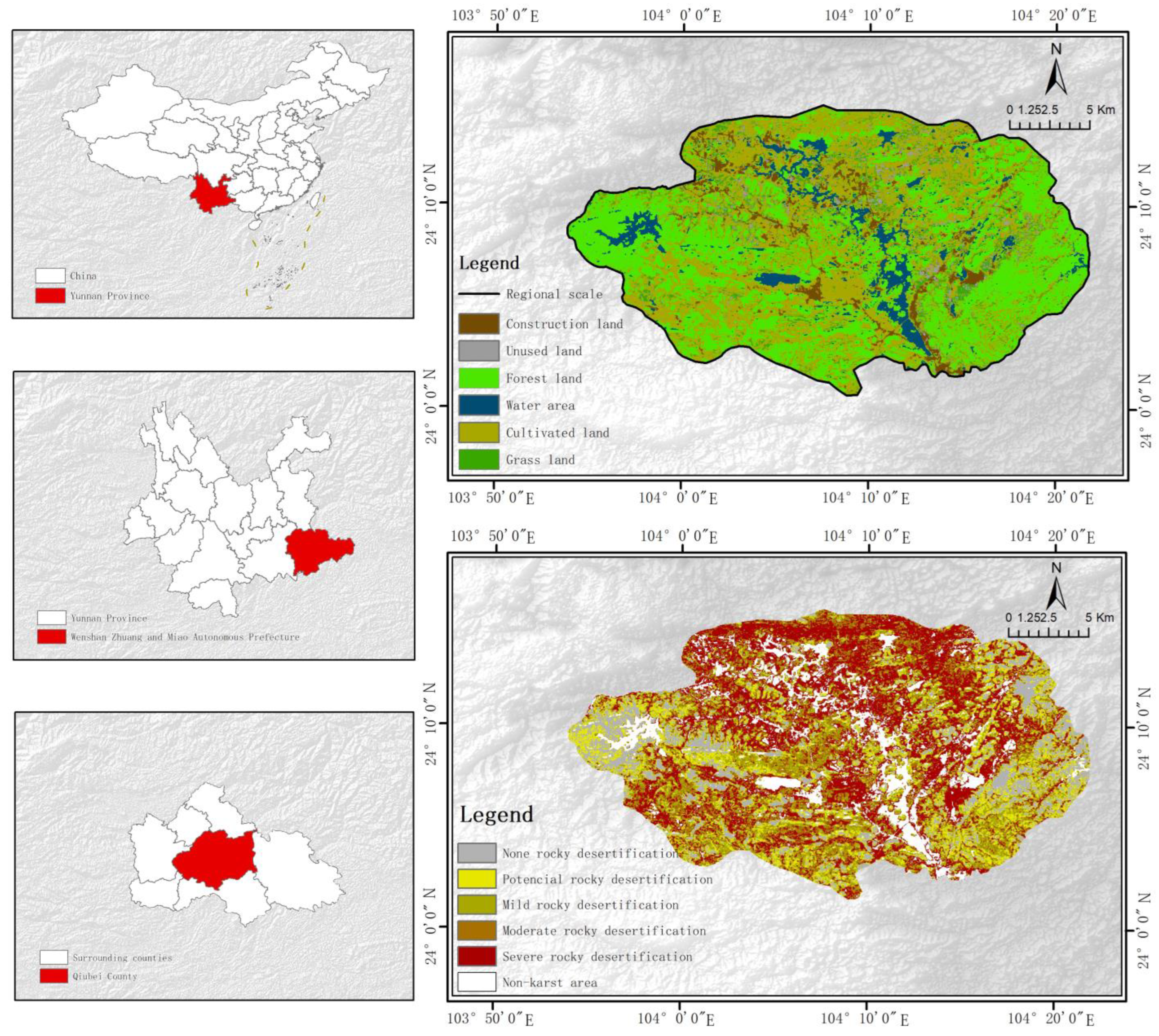
2.1. Study Area

Positioned in the southwest of the Qiangui Platform and the karst mountain region of southeast Yunnan Province, China, the Puzhehei karst landscape exhibits a distinct topographical pattern, with higher elevations toward the southwest and lower elevations toward the northeast. The unique combination of karst mountain landforms and karst lakes within this region forms the sole karst wetland ecosystem found in the Yunnan Plateau Lakes. The area contains the Puzhehei National Scenic Area (103°56′53″–104°9′54″ E, 24°5′58″–24°11′53″ N), the Puzhehei Provincial Nature Reserve (104°3′24″–104°8′18″ E, 24°6′18″–24°11′40″ N), and the Puzhehei National Wetland Park (24°3′53″–24°11′40″ N, 104°8′25″–104°9′03″ E), as well as Damoshan Village, Puzhehei Village, Badaoshao Village, and Yidu Village in Qiubei County; the research area is 361.79 km2 in total. The region’s geographical location and altitude give rise to two distinct climatic characteristics, namely an oceanic climate and a continental climate, placing it within the tropical plateau monsoon climate of Central Asia. Within its territory, the Nanpan River, the Liulangdong River, and numerous inland rivers serve as valuable sources of freshwater for the oases found in the karst landscape of Puzhehei. Additionally, the prevalence of red soils and red–yellow soils, as well as the local presence of sandy shale, limestone, and other soil-forming matrices, contribute to the area’s soil composition. Furthermore, the region’s western, southern, and central parts exhibit well-developed karst landforms. Qiubei County has 3 towns and 9 townships, as well as 1262 natural villages, with a total population of 500,000; the agricultural population accounts for 89.8% of the total population. Seven ethnic minorities, namely, Han, Zhuang, Miao, Yi, Yao, Bai, and Hui, live in the county, with the ethnic minority population accounting for 64.7% of the total population. In recent years, the economy of Qiubei County has been developing rapidly, and Qiubei County’s baking tobacco, chili pepper, and animal husbandry have developed into the pillar industries of the local economy. The secondary industry mainly consists of coal mining, electrical power, construction and building materials, brewing, smelting, and other industries, which have shown a good potential for economic development (Figure 1).

2.2. Date Sources

The datasets utilized in this study consist of DEM data, normalized differential vegetation index data, rocky desertification data, road vector data, soil erodible data, and land use data.
The specific data sources and descriptions employed are as follows:
(1)
Google Earth provided the Digital Elevation Model (DEM, ASTER GDEM 30 M)(https://earth.google.com.hk/, accessed on 19 December 2022);
(2)
The dataset of surface water and normalized differential vegetation index(NDVI, 30 m spatial resolution) were obtained from the Geospatial Data Cloud website (http://www.gscloud.cn/, accessed on 28 December 2020);
(3)
The distribution data and sensitivity data of rocky desertification were derived from the research results of Xu Hongfeng [24] et al.; the data were processed via Landsat through the Google Earth Engine cloud computing platform (accessed on 25 December 2020);
(4)
Soil erodible data were created using the China Soil Database at a scale of 1:1 million (https://vdb3.soil.csdb.cn/, accessed on 13 December 2022);
(5)
The roadway vector data were obtained through the OpenStreetMap website (https://www.openstreetmap.org/, accessed on 2 December 2022);
(6)
The land use data (10 m spatial resolution) were obtained from the European Space Agency (https://viewer.esa-worldcover.org/, accessed on 27 November 2022). Six different types of classifications were made for the current study region: forest land, water areas, grassland, cultivated land, unutilized land, and construction land. After accuracy verification, the Kappa coefficient was verified to be 0.9342, with an overall classification accuracy of 94.9013%.

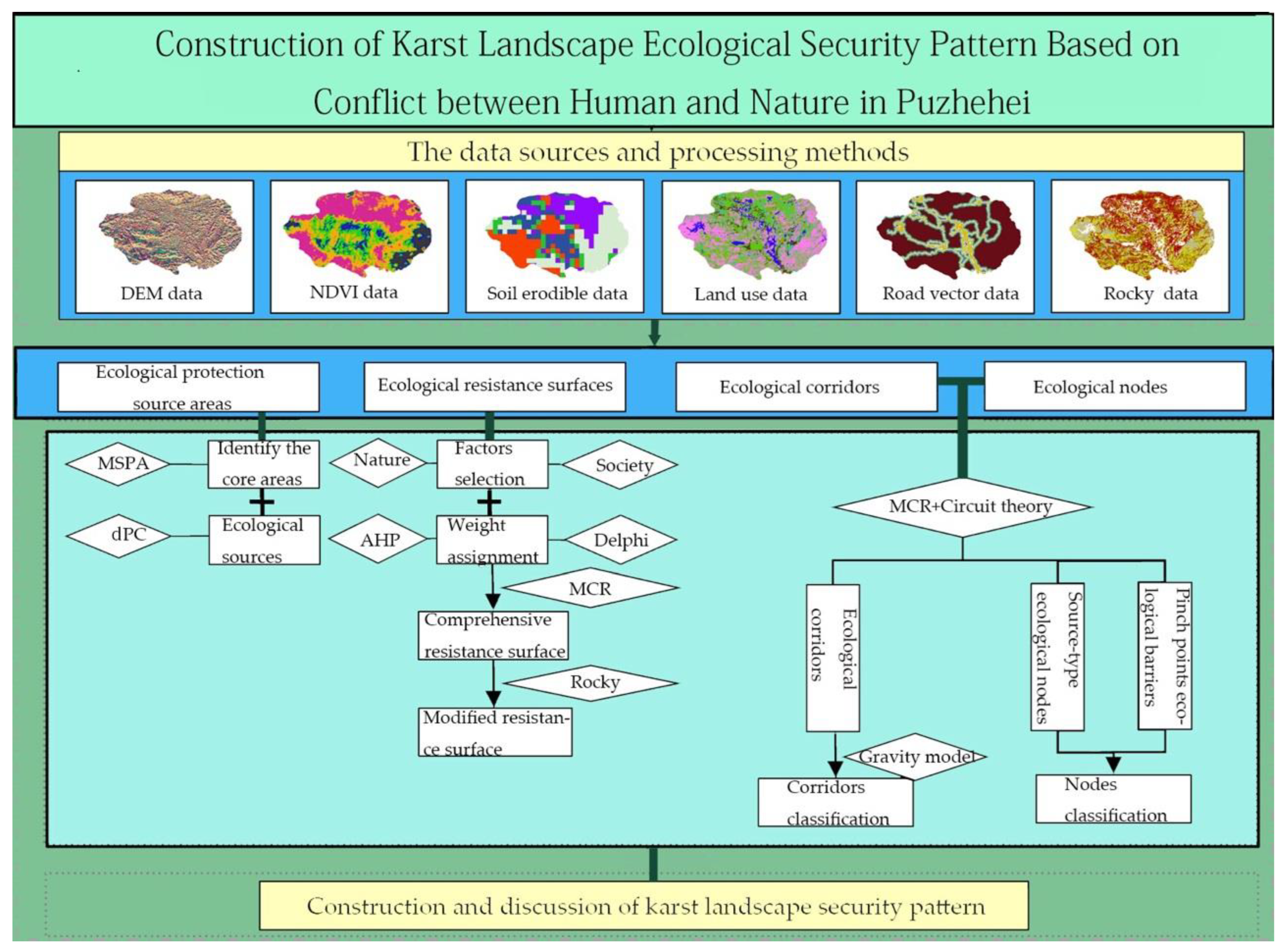
2.3. Analysis Methods

Puzhehei is dispersed with a typical karst lithology; therefore, this study developed an ecological source area through a karst landscape “MSPA analysis and connectivity analysis”. The focused modification of the fundamental resistance surface employed rocky desertification sensitivity data to represent the karst region’s characteristics; corridors were identified by MCR and circuit theory; the “ecological pinch points” and “ecological barriers” were extracted based on the Pinchpoint Mapper component and the Barrier Mapper component, resulting in the construction of a karst landscape ecological security pattern of Puzhehei (Figure 2).

2.3.1. Ecological Source Areas Identification

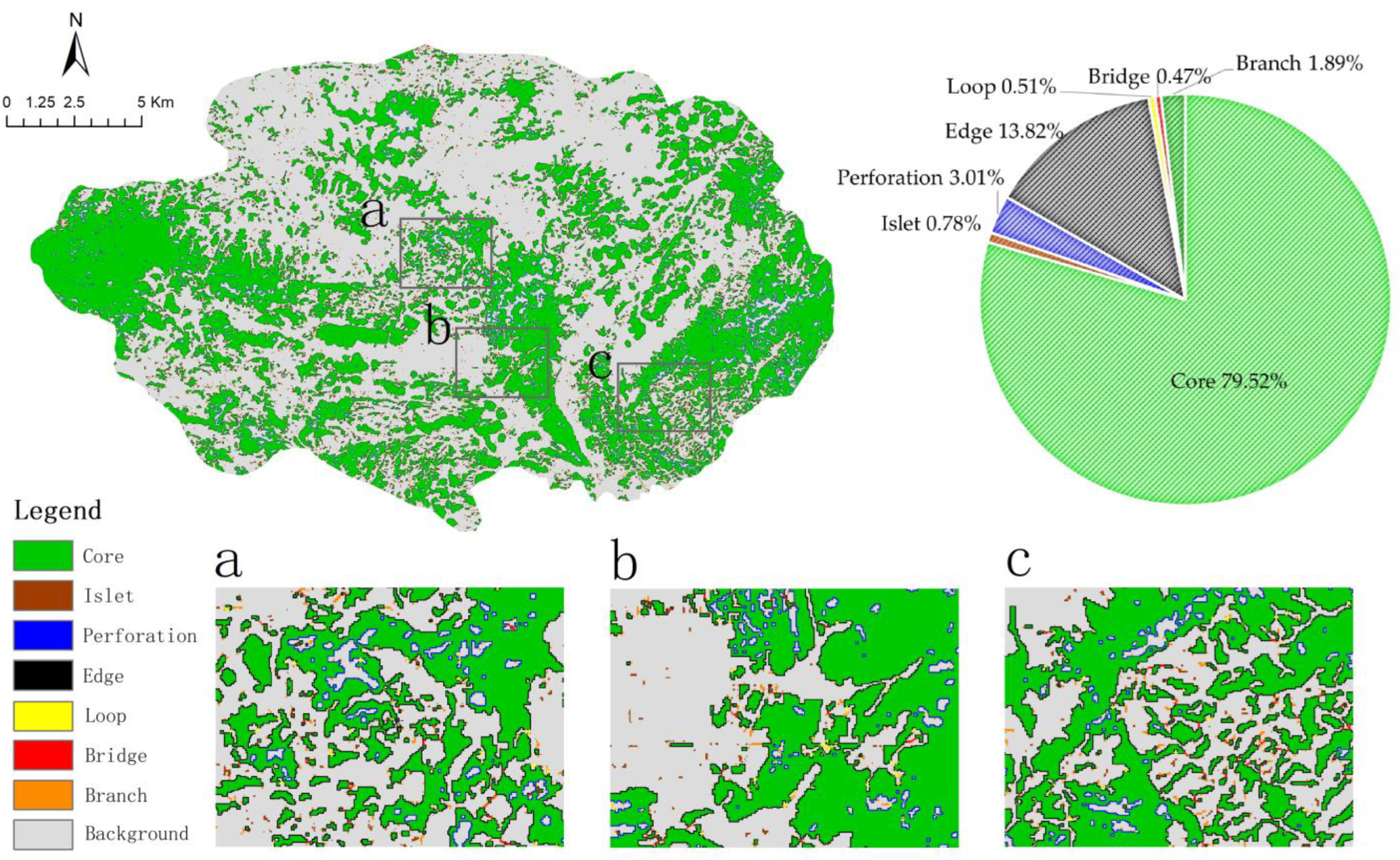
Identification of Landscape Elements Based on MSPA Analysis

Based on the landscape types, the forest land and water areas were treated as research prospects [25], and the rest of the landscape types were viewed as the research background, which were converted into TIFF format binary raster data with a resolution of 30 m × 30 m. To analyze the karst landscape structure of Puzhehei, we employed the MSPA technique. By utilizing the Guidos Toolbox and applying the 8-connectivity analysis method, we identified seven non-overlapping landscape types. The core areas extracted from these types were subsequently considered as the initial ecological source areas for evaluating landscape connectivity.

Selection of Ecological Source Areas Based on Landscape Connectivity

Based on the MSPA analysis and combined with the actual situation of the current study area, the core area patches were extracted for landscape connectivity analysis. Analysis was conducted using Conefor 2.6 [26] and the dPC of the core area was determined. A total of 11 core area patches with a score of dPC > 10.0 were selected as the final ecological source areas, and the geometric center of the ecological source areas were acquired as the source/junction using the “Feature To Point” tool in ArcGIS software. The integral index of connectivity (IIC) [27], the probability of connectivity (PC) [28], and the landscape connectivity index (dPC) [29] were chosen as the landscape connectivity evaluation indexes, respectively. The formulas are as follows:
IIC = i = 1 n j = 1 n a i a j 1 + nl i j A L 2
PC = i = 1 n j = 1 n a i a j P i j * A L 2
dPC = 100 × PC PC remove PC
where n shows the overall number of patches; a i indicates where the patch i is located; a j is the area of the patch j ; P i j * is the highest value that the product of path probabilities can reach between patch i and j ; A L is the entire landscape area; IIC indicates the patch’s overall connection index; PC is the possible connectivity index; dPC is a patch’s significance; PC remove is the potential connection index of each landscape after deleting specific landscape components.

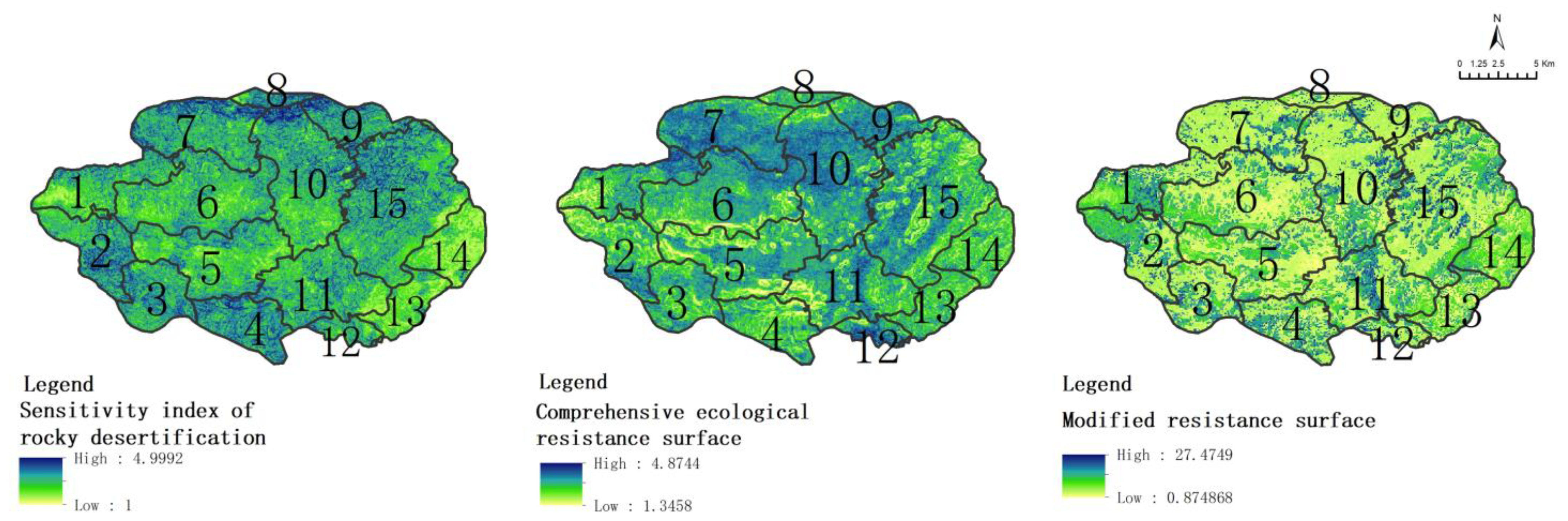
2.3.2. Ecological Resistance Surface Construction and Correction

Ecological Resistance Surface Construction

The research area has a typical karst landform as its defining feature, encompassing rock, water, vegetation, and soil, as well as various natural and human elements. These components combine to form a complex karst landscape geographical system in Puzhehei. Using the findings of prior studies and the actual ecological circumstances in the present study area, ArcGIS software was used to grade 10 individual resistance factors which were further divided into 5 classes using the relevant literature and the natural breakpoint method to evaluate the resistance factors. To ascertain the weight of each factor, the AHP and Delphi method were employed. Questionnaires were distributed to experts in the field of karst landscape ecological planning and related disciplines to determine the relative importance of each evaluation index layer and factor layer. The weights of each index system were derived through normalized conversion, ensuring a consistency ratio (CR) of less than 0.1 and passing the one-time test for the judgment matrix. The classification and assignment of each resistance factor are provided in Table 1.

Ecological Resistance Surface Correction

Rocky desertification not only affects the quality of the surrounding ecosystem but also has intimate ties to the connectivity of ecological source areas, the relevance of ecological nodes, and the accessibility of ecological corridors. The rocky desertification sensitivity [30] has a sustainable impact on karst areas, and its sensitivity index formula is as follows:
S i = D i × P i × C i 3
where S i is the sensitivity index of rock desertification in the assessment area i ; D i ,   P i ,   C i are the topographic slope, plant cover, and carbonate-exposed regions in the assessment area i , respectively.
According to previous research methods [31], in order to select the rocky aridification response to altering the general resistance surface to reflect the unique characteristics of rocky desertification in karst contexts, the formula is as follows:
R i = N L i N L α   ×   R
where R i is the ecological resistance coefficient of the raster i ; N L i refers to the rocky desertification sensitivity index of the raster i ; N L α is the average rocky desertification sensitivity of land use type α corresponding to the raster i ; R is the resistance factor of the land use type corresponding to the raster i .

2.3.3. Ecological Corridor Identification and Importance Grading

Ecological Corridor Identification Based on the MCR Model

The MCR model [32] is as follows:
MCR = f m i n j = n i = m D i j × R i
where MCR reflects the lowest cumulative resistance value of a species or ecological process from a source i to j ; f m i n is the ecological process and the minimal cumulative resistance, which are positively correlated; D i j is the spatial separation from the source patch i to j ; R i is the resistance coefficient when flowing through the source patch i .

Ecological Corridor Identification Based on the Circuit Theory

Circuit theory is a technique for locating ecological nodes and corridors [33]. The Build Network and Map Linkages component of the Linkage Mapper toolbox [34] was used, and the cost-weighted distance threshold for the truncation of ecological corridors was set at 200 m to determine the two nearby source sites’ lowest-cost routes and to create a complete loop.

Importance Classification of Ecological Corridor Based on the Gravity Model

The gravity model [35] is a mathematical equation that has evolved from the law of gravity, which is used to analyze the level of spatial interactions. An interaction matrix is created between each ecological source region based on the gravity model to determine the interaction force index between the two source locations. According to the importance evaluation results, crucial and general ecological corridors were separated from each other, and the formula is as follows:
G i j = L m a x 2 ln S i S j L i j 2 P i P j
where G i j is the strength of interaction between patch i and j; S i is the region of patch i; S j is the region of patch j; P i ,   P j indicates the size of the entire resistance value of patch i, and j, respectively; L i j reflects the size of the total resistance value of the potential corridors of patch i and j, respectively; and L m a x is the highest level of resistance found throughout all corridors.

2.3.4. Ecological Node Identification and Importance Grading

Ecological Node Identification

Identification of ecological nodes is crucial for the development of ecological security patterns, exerting control over both static conditions and dynamic changes in the landscape. This research integrated the center derived from the spatial distribution of ecological sources using MCR to identify “source-type ecological nodes”. Additionally, the “ecological pinch points” and “ecological barriers” were identified as ecological nodes by employing the Pinchpoint Mapper component and the Barrier Mapper component of the Linkage Mapper toolkit [36].
Ecological pinch points refer to regions that species are compelled to traverse or are highly likely to traverse while migrating between source areas [37]. Utilizing the corridors derived from the Build Network and Map Linkages component, the Pinchpoint Mapper tool was employed to execute both all-to-one and pairwise modes. These modes were then integrated with the Circuitscape graph theory plug-in, utilizing a cost-weighted cutoff distance of 500 m. Consequently, current density maps were generated for both all-to-one and pairwise modes, allowing for the location of areas with the highest current density, denoted as “ecological pinch points”. Additionally, ecological barrier points [38] refer to the region that influences the quality of ecological corridors and prevents species migration, the cost of restoration of barrier points, and other aspects of consideration. Therefore, the mobile window’s searching radius was established at 100 m, and the percentage of unselected improvement scores relative to corridor LCD (the least-cost distance) was calculated, as well as the percentage of selected improvement scores relative to corridor LCD analysis models in the Barrier Mapper component to identify “ecological barrier points”.

Importance Classification of Ecological Nodes

Combining the distribution of crucial and general ecological corridors, the intersection point located in crucial ecological corridors with crucial corridors, and crucial ecological corridors with general ecological corridors is regarded as a crucial ecological node. One of them is selected as the crucial ecological node when multiple crucial ecological nodes overlap, and the remainder are regarded as general ecological nodes.

3. Results

3.1. Determination of Ecological Protection Source Areas

Through the application of the MSPA analysis, the present study was able to identify seven distinct categories of landscape structures. As depicted in Figure 2, the ecological land of Puzhehei encompassed a total area of 166.6572 km2, representing 46.06% of the entire study area. The findings from the MSPA analysis, as presented in Table 2, revealed that the core area accounted for 132.5291 km2, constituting 79.52% of the MSPA landscape types. This core area exhibited the highest proportion, with an edge area measuring 23.0371 km2. It is important to note that the core area was primarily dispersed in the research area’s eastern and western parts, The landscape was very dispersed, with a few tiny core locations sprinkled here and there. Moreover, the MSPA study showed that the core region was larger than 100 km2. From this analysis, core area patches with a dPC greater than or equal to 10 were identified as the primary sources of landscape connectivity. Altogether, a total of 11 ecological sources with a combined area of 77.275 km2 accounted for 21.36% of the present study area and 46.37% of the MSPA landscape-type area. According to the land use study, the majority of the land use areas were made up of forest land and water areas, with respective areas of 59.6682 km2 and 17.6068 km2. The karst region’s forest land and water areas are extremely important for controlling the ecosystem’s diversity, stability, and persistence. They are essential elements for maintaining a favorable environment, sustainable resources, and ecological health (Figure 3, Table 2).
In terms of spatial distribution, the landscape patches numbered 20 and 26 exhibited relatively high importance, as indicated by their patch importance indexes of 52.3485 km2 and 44.8115 km2, respectively. These patches are primarily found in Puzhehei Village, Yidu Village, Xiangqi Village, Mazhelong Village, and other central and southeastern regions (Figure 4, Table 3).

3.2. Construction of Ecological Resistance Surfaces

The ecological comprehensive resistance surface was corrected in combination with rocky desertification sensitivity, resulting in a more accurate spatial arrangement of the Puzhehei karst landscape and a more rational construction of the ecological security pattern (Figure 5). It was observed that Xinzhai Village, Shanxin Village, Shuanglongying Village, Mazhelong Village, Longqiao Village, and Lijiazhuang Village, located in the northern and southern periphery, exhibited a heightened level of sensitivity to rocky desertification. Cultivated land and forest land were taken into consideration as the primary regions, characterized by a substantial degree of vegetation cover and continuous distribution of karst lake landscapes. Puzhehei Village, Yidu Village, and Dabuhong Village exhibited a low level of sensitivity to rocky desertification, and there were a certain number of karst lakes. Similarly, Xiangqi Village, Zhenxing Community, Badaoshao Village, including the central part of Badaoshao Village, and the southern part of Yuezhe Village demonstrated a low level of sensitivity to rocky desertification due to the presence of well-developed water systems, low vegetation cover, and intensive human activities. The distribution of high resistance value areas can be observed forming a band from north to south, with comparatively lower resistance values found in the southwest and east.

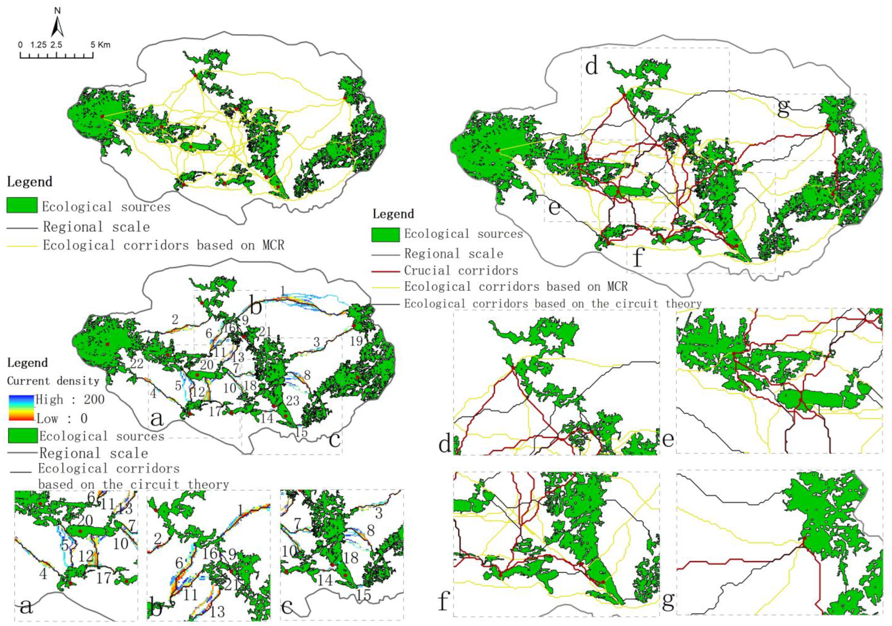
3.3. Ecological Corridor Identification and Importance Classification

Ecological corridors, functioning as linear landscape units, possess structural attributes that significantly impact ecological processes within a landscape. In the current study, 78 ecological corridors were defined, spanning a combined length of 545.186 km. Among these corridors, 55 were determined using the MCR model, with a cumulative length of 483.582 km, while 23 corridors were identified through circuit theory, totaling 61.604 km in length. The strength of interactions among 11 ecological source areas was analyzed using gravity modeling, resulting in the construction of an interaction matrix. Corridors with an interaction strength exceeding 5.0 were deemed significant ecological corridors, leading to the identification of a total of 12 corridors, which accounted for 15.38% of the overall corridor network, while the remaining 66 corridors were general ecological corridors, accounting for 84.62% of the total (Figure 6).
The findings from the analysis of ecological source site interactions indicate that the interaction strength between source sites 1 and 7 was the highest, measuring 23.1563, with a corridor length of 1.564 km. Additionally, the interaction strength between source sites 2 and 10 ranked second highest at 13.2688, with a corridor length of 5.616 km. Thus, the findings demonstrate that there was stronger connectivity between source sites 1 and 7, as well as between source sites 2 and 10. This increased connectivity is accompanied by a high average speed of species movement, minimal barriers leading to low genetic variation and minimal population differences, and enhanced ease of species migration, foraging, exchange, reproduction, and survival within the ecological process. Conversely, the interaction strength between source sites 3 and 10 was notably low, measuring at 0.3181, indicating weak connectivity and substantial resistance to species movement, blocking the invasion of exotic species while hindering the migration and exchange of original species (Table 4).

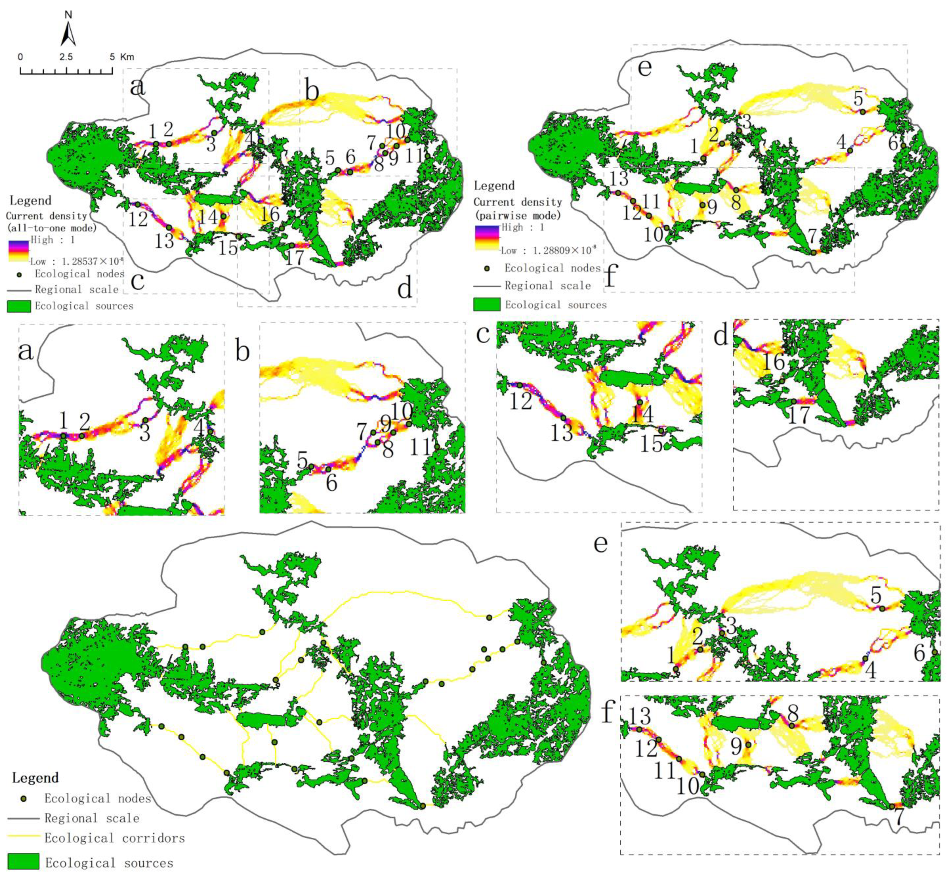
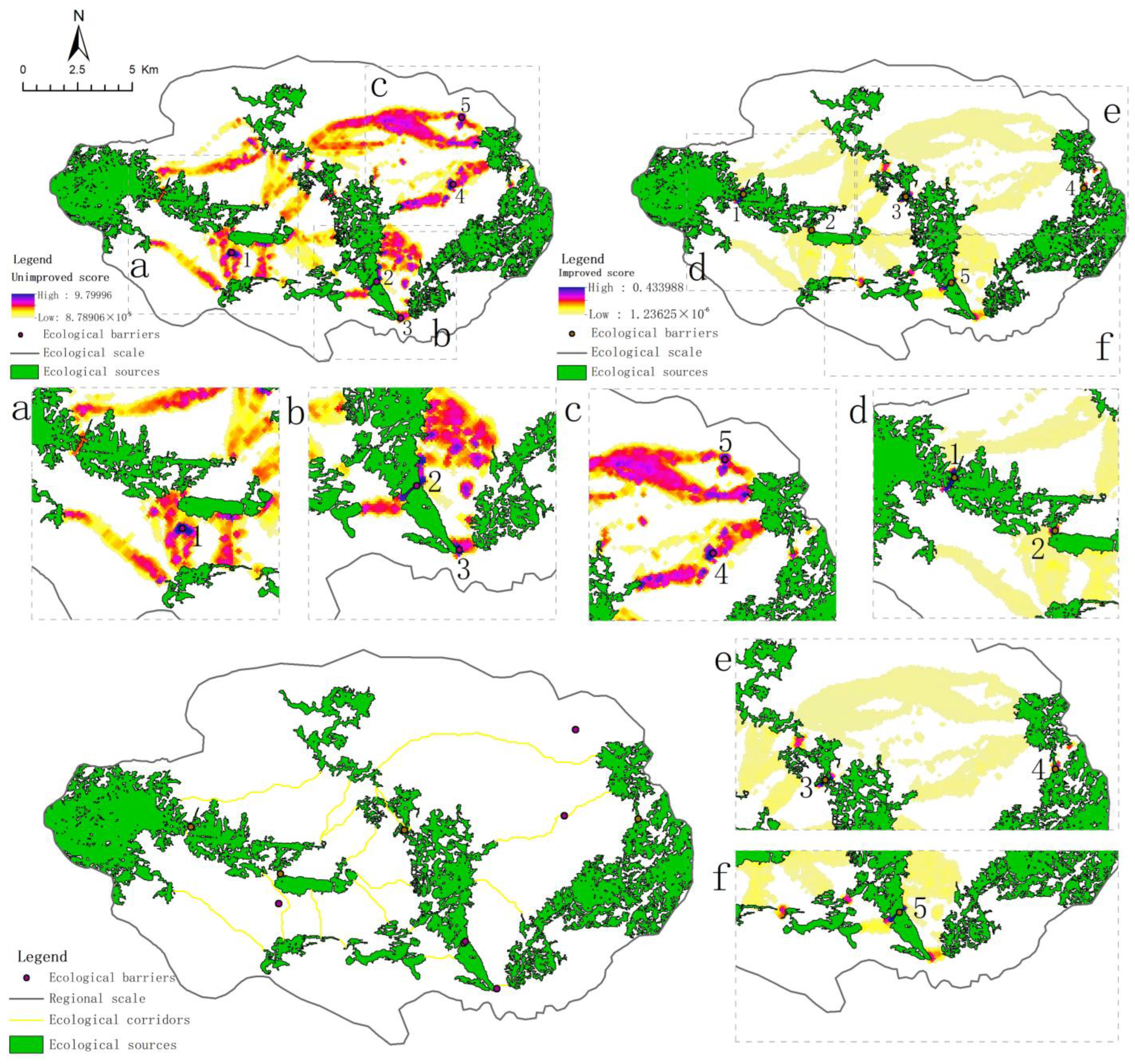
3.4. Ecological Node Identification and Importance Classification

In this study, the identification and screening of ecological nodes were conducted to examine their significance in species migration and dispersal processes. In total, 51 ecological nodes were found, with 11 categorized as “source-type ecological nodes”, which identified them as the areas with the highest conservation value and the best habitat quality; the identification of “ecological pinch points” and “ecological barrier points” resulted in a total of 30 pinch points, with 17 and 13 identified, respectively, through the all-to-one and pairwise modes and through the application of circuit theory (Figure 7). Based on the Barrier Mapper component (Figure 8), 10 ecological barrier points were discovered. The intersections of ecological corridors were chosen to identify the crucial ecological nodes, which led to the discovery of 16 crucial ecological nodes and 35 general ecological nodes.

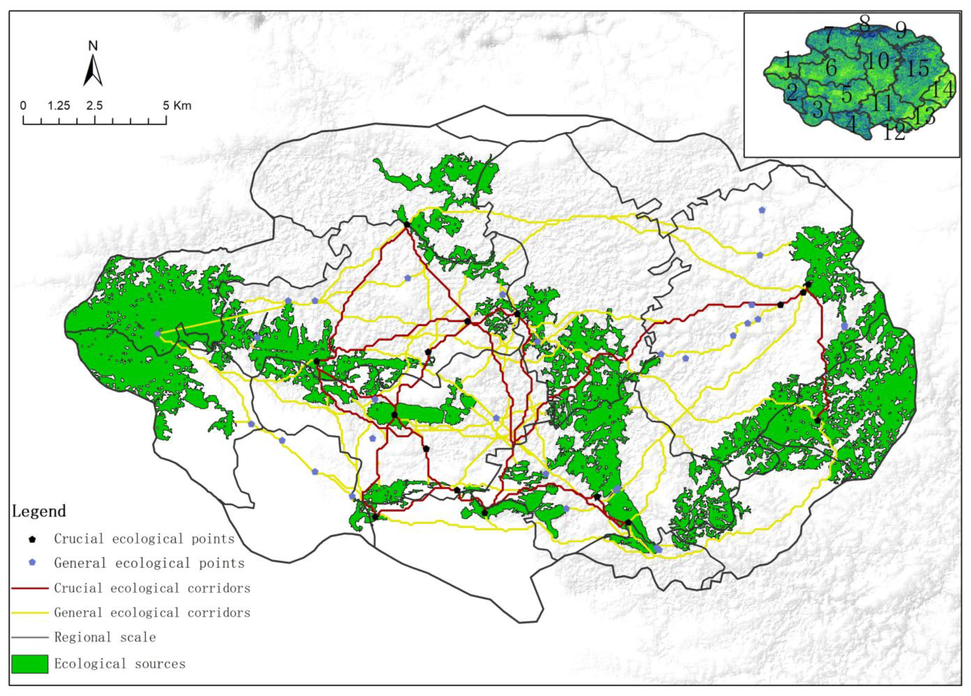
3.5. Construction of Karst Landscape Ecological Security Pattern of Puzhehei

Drawing upon the aforementioned research findings and the inherent ecological characteristics of the karst landscape in Puzhehei, China, a comprehensive karst landscape ecological security pattern was established. According to the construction situation of the resistance surface, the high resistance value areas are predominantly dispersed in scattered spots, some of which are concentrated and spread outward. On the one hand, this pattern can be attributed to the strategic positioning of these areas within the central regions of Puzhehei Lake in Puzhehei Village and Luoshuidong Lake in Xinzhai Village, where the emphasis has been placed on ecological services and ecotourism development, which have been identified as key areas of construction for the development of the tourism economy and the implementation of cultural and ecotourism. These areas, characterized by a more developed economy within the region, play a crucial role in fostering the general development of cities and villages, but the ecological patches in these areas are more fragmented due to the high degree of human interference, resulting in a greater impact on the ecological environment; on the other hand, certain locations with well-developed water systems, such as Bailong Lake in Yuezhe Village and the lake area of Xianrendong Lake in Yidu Village, exhibit a higher concentration of lake areas. This study primarily examines the hydrodynamic resistance encountered by species upon reaching the ecological source, resulting in a notably high resistance value. Regions exhibiting relatively low resistance values are predominantly situated in the southwestern and a small portion of the northern area, characterized by reduced anthropogenic disturbances and offering abundant high-quality habitat resources and environments for species.
A significant variance may be seen in the research area’s spatial distribution of ecological corridors, with the majority of corridors concentrated in Badaoshao Village and Damoshan Village due to the fragmentation of ecological sources, connecting to the ecological sources of the surrounding areas, such as Puzhehei Village and Yidu Village. Among them, the significant ecological corridors were primarily situated in the central and eastern regions of Badaoshao Village and the southern region of Damoshan Village, facilitating the connection of diverse source areas. These corridors serve as effective spatial pathways for species migration, thereby contributing to the improvement of ecosystem health. Additionally, the general ecological corridors encompass the entirety of the current study area, including administrative villages, such as Xinzhai Village and Mazhelong Village, promoting ecological mobility. The spatial outcome of environmental and biological co-evolution is significantly influenced by these corridors.
Regarding the ecological nodes’ spatial configuration, the spatial distribution of the crucial ecological nodes mirrored that of the source areas, with a predominant concentration in the southern and eastern regions of Damoshan Village, the central and southern parts of Badaoshao Village, the northern part of Longqiao Village, the southern portion of Yidu Village, and the eastern portion of Mazhelong Village, which indicates that these areas need to be delineated with reasonable ecological protection boundaries, taking into account the specific spatial location of key ecological nodes, promoting connectivity within the region, and facilitating the movement of animals between source locations. The general ecological nodes in the northern and western regions of Damoshan Village, as well as the northern and eastern regions of Lijiazhuang Village, Yidu Village, and Mazhelong Village, are dispersed in nature. Thus, the effectiveness of species migration and diffusion is diminished, and there exists a certain level of substitutability. By constructing the Puzhehei karst ecological security pattern (Figure 9) and focusing on the construction of a natural ecological mountain landscape belt and water system landscape, the karst landscape system of “city in the green, mountain surrounded by water, and people walking in the scenery” will be created, as well as the co-construction of the Puzhehei Karst Oasis.

4. Discussion

Harmonious coexistence between humans and nature is a new form of civilization, yet conflict is an integral part of the conservation process in the global ecological civilization [39]. The roles of humans and nature are often intertwined in the evolution of landscapes, with humans forming both part of the organism and a genetic and environmental orienting factor. Under the action of human influences, the landscape is affected mainly by changes in land use, which itself includes human utilization and management systems. This paper integrates the biodiversity characteristics of karst landscapes and the spatial distribution of major conservation objects. From a spatial distribution standpoint, the specific villages of Yuezhe, Dabuhong, Damoshan, and Badaoshao, located in the east, exhibited a significant concentration of ecological sources, along with a dense distribution of ecological corridors and nodes. These areas represent a well-preserved segment of the Puzhehei karst landscape ecosystem, and they are essential in promoting the hydrological cycle, ecosystem stabilization, biodiversity life processes, and various other essential ecological functions. There were also some ecological sources, corridors, and nodes in Puzhehei Village and Yidu Village, especially concentrated in Puzhehei Lake, Xianrendong Lake, and scenic spots, such as the Puzhehei National Wetland Park and the Puzhehei karst nature area, which together exhibit a distinctive amalgamation of nature and humanity, resulting in a unique ecological and cultural landscape. These features contribute to the formation of exceptional karst wetland ecological landscape resources and cultural resources for ethnic minorities. Consequently, the region exhibits significant potential for the development of an immersive nature experience and eco-cultural tourism. Mazhelong Village, Xiangqi Village, and Zhenxing Community exhibited a notable concentration of woodland and grassland, characterized by abundant vegetation coverage. The ecological land within these areas holds significant ecological value, as it contributes to the enhancement of biodiversity, safeguarding ecological stability and karst landforms. Conversely, the distribution of ecological sources, corridors, and nodes in Xinzhai Village, Shanxin Village, Shuanglongying Village, Lijiazhuang Village, Longqiao Village, and Matoushan Village was comparatively scarce, or in some cases, nonexistent. The degradation of the karst wetland and anthropogenic disturbance have contributed to the disrupted growth of native vegetation and the reduction in vegetation cover in Puzhehei. Consequently, the ecological system has undergone structural changes and experienced a decline in ecological function. To address these issues, it may be necessary to implement scientific and technical methods for ecological restoration and reconstruction.
The sustainable development of Puzhehei is intricately linked to the establishment of ecological security patterns. The research methods and findings presented here can offer a solid scientific foundation for the development of diverse, stable, and sustainable karst landscapes. In terms of the novelty of the research methodology, the use of MSPA analysis and landscape connectivity analysis to identify ecological source areas can qualitatively identify core area patches with a relative concentration of spatial morphological attributes as well as quantitatively assess the habitat quality of individual patches, with the two analytical mechanisms complementing each other; secondly, the comprehensive use of two methods, the MCR and circuit theory, to construct the karst landscape ecological security pattern realizes the coupling process of ecological elements and ecological processes, which is more conducive to the precise construction and biodiversity protection of the Puzhehei karst landscape. In terms of the diversity of research perspectives, the Puzhehei Karst landscape is treated as a unified system whole, covering elements, such as woodland, grassland, and water, giving full play to its ecological, landscape, cultural, and other functions. Unlike previous studies that split up the research elements, this study innovatively constructed a security pattern of the karst landscape and enhanced the integration. However, the current study exhibits certain limitations in its evaluation process. On the one hand, the conflict between human beings and nature is only a relative concept, and whilst some of the impacts are ostensibly natural, the underlying causes are related to human activities. However, the concept of human activities is complicated by the organic integration of social and natural sciences, together with the specificity and sensitivity of karst landscapes, making the research process and the construction of karst landscape safety patterns somewhat subjective; on the other hand, under the dual role of natural condition constraints and the influence of human activities, a static patch–corridor–matrix landscape structure was formed in the process of constructing the ecological security pattern. The dynamic evolutionary processes of that landscape structure, such as the ecological and evolutionary effects of patches, the discontinuity and connectivity of corridors, and the types of landscape elements in the matrix, are ignored.
The primary problem facing ecological construction is how to mitigate the relationship between humans and nature, a relationship which is often characterized by complexity, dynamism, and diversity, making it difficult to find effective and feasible ways to mitigate any negative impacts. Firstly, it is necessary to continuously improve the system of territorial spatial governance and optimize the territorial spatial pattern, so that the production space is intensive and efficient, the living space is livable and moderate, and the ecological space is clear and beautiful, so as to form a new territorial spatial protection pattern for high-quality development. Secondly, it is vital to enhance the diversity, stability, and sustainability of ecosystems, and to promote the comprehensive management and systematic restoration of its multiple elements, such as mountains, water, forests, fields, lakes, grasses, and sands, in an integrated manner, so as to form a positive cyclical relationship between human beings and nature. In the case of karst-type nature reserves, enhancing the ecological environment of Puzhehei and preserving the ecological integrity in the karst water-deficient region of southeast Yunnan are crucial prerequisites for upholding social stability, fostering economic progress, and ensuring ecological security among the border ethnic communities. Hence, it is imperative for future research to undertake a comprehensive investigation into the ecological planning of karst landscapes utilizing multi-scale, multi-dimensional, and composite evaluation models.
As far as the study area is concerned, the area is facing the double pressure of economic development and ecological protection, and, at the same time, it is facing great challenges in terms of bio-ecological security, regional environmental pollution, and territorial spatial development, while the modernization of the governance system and governance capacity have not yet been achieved. We should endeavor to promote ecological protection and restoration, coordinate the management mechanism for ecological protection and restoration, implement soil, river, and lake restoration, and coordinate the design of environmental function upgrading for different landscape types, different ecosystem types, and different functional areas. We should also implement the ecological resource management system, strictly enforce the basic farmland protection system and the regulation of wetland use, strengthen the evaluation and monitoring of the quality of farmland, and establish a mechanism for rewarding and penalizing the effectiveness of wetland protection, as well as improving the system of compensated use of resources and ecological compensation, expanding the scope of compensated use of state-owned land, reducing the scope of land allocation for non-public welfare, exploring the establishment of a diversified ecological compensation mechanism, improving the incentive and constraint mechanism combining the effectiveness of ecological protection with the distribution of funds, reasonably determining the mode and scope of compensation, and promoting the construction of a systematic system of compensation for ecological protection and a platform for communication and coordination.

5. Conclusions

In this academic study, the focus was on the Puzhehei karst landscape located in Qiubei County, Wenshan Prefecture, Yunnan Province, China. The creation of an ecological security pattern was aided by the discovery of ecological sources, corridors, and nodes within the landscape, offering innovative approaches for achieving ecologically sustainable development in karst areas, and the following conclusions were drawn:
(1)
The findings of this study indicate that the Puzhehei karst area encompasses a total of 166.6572 km2 of ecological land, representing 46.06% of the present study area. Additionally, the ecological source areas within this region amount to 77.275 km2, accounting for 21.36% of the total study area.
(2)
The MCR model and circuit theory were utilized to identify a total of 78 ecological corridors, spanning a combined length of 545.186 km. These corridors were categorized into 12 crucial corridors and 66 general corridors.
(3)
In this study, a total of 51 ecological nodes were identified, encompassing 11 “source-type ecological nodes”, 30 “ecological pinch points”, and 10 “ecological barriers”. Among these nodes, 16 were identified as crucial ecological nodes.

Author Contributions

Conceptualization, C.L. and J.W.; methodology, C.L.; software, C.L.; validation, C.L.; formal analysis, C.L.; investigation, C.L. and K.X.; resources, C.L. and X.L.; data curation, C.L.; writing—original draft preparation, C.L.; writing—review and editing, C.L.; visualization, C.L.; supervision, J.W.; project administration, J.W.; funding acquisition, J.W. All authors have read and agreed to the published version of the manuscript.

Funding

This research was funded by the National Natural Science Foundation of China (Project name: Study on Silicon biomineralization in bamboos; project code: 31460169) as well as the Scientific Research Foundation of Yunnan Education Committee (Project name: Evaluation of landscape ecological suitability and construction of landscape security pattern in Puzhehei, Yunnan Province; project code: 2023Y0745).

Institutional Review Board Statement

Not applicable.

Informed Consent Statement

Not applicable.

Data Availability Statement

All data generated or analyzed during this study are included in the published article.

Acknowledgments

We are grateful to our team for data collection and to the people who gave us directions and explanations in the field.

Conflicts of Interest

The authors declare no conflicts of interest.

References

  1. Yan, J.; Du, S.; Zhang, J.; Yu, W. Analyzing Transregional Vernacular Cultural Landscape Security Patterns with a Nature–Culture Lens: A Case Study of the Yangtze River Delta Demonstration Area, China. Land 2023, 12, 661. [Google Scholar] [CrossRef]
  2. Shi, Y.; Li, J.; Shi, T.; Xiu, D.; Chu, Y. Research of Sponge City Landscape Planning Based on Landscape Security Pattern. J. Phys. Conf. Series. 2021, 2002, 012076. [Google Scholar] [CrossRef]
  3. Zhao, X.Q.; Xu, X.H. Research on landscape ecological security pattern in a Eucalyptus introduced region based on biodiversity conservation. Russ. J. Ecol. 2015, 46, 59–70. [Google Scholar] [CrossRef]
  4. Malá, J.; Hrich, K.; Vaculíková, K.; Lejska, S. Multicriterial approach to the determination of buffer zones for the Moravian Karst protected landscape area in the Czech Republic. Environ. Monit. Assess. 2022, 194, 103. [Google Scholar] [CrossRef] [PubMed]
  5. Čech, V.; Chrastina, P.; Gregorová, B.; Hronček, P.; Klamár, R.; Košová, V. Analysis of attendance and speleotourism potential of accessible caves in karst landscape of Slovakia. Sustainability 2021, 13, 5881. [Google Scholar] [CrossRef]
  6. Zhang, X.; Bianchi, T.S.; Cohen, M.J.; Martin, J.B.; Quintero, C.J.; Brown, A.L.; Ares, A.M.; Heffernan, J.B.; Ward, N.; Osborne, T.Z.; et al. Initiation and development of wetlands in southern Florida karst landscape associated with accumulation of organic matter and vegetation evolution. J. Geophys. Res. Biogeosciences 2019, 124, 1604–1617. [Google Scholar] [CrossRef]
  7. Aranburu, A.; Arriolabengoa, M.; Iriarte, E.; Giralt, S.; Yusta, I.; Martínez-Pillado, V.; del Val, M.; Moreno, J.; Jiménez-Sánchez, M. Karst landscape evolution in the littoral area of the Bay of Biscay (north Iberian Peninsula). Quat. Int. 2015, 364, 217–230. [Google Scholar] [CrossRef]
  8. Alexandrowicz, S.W.; Alexandrowicz, Z. Pattern of karst landscape of the Cracow Upland (South Poland). Acta Carsologica 2003, 32, 39–56. [Google Scholar] [CrossRef]
  9. Limbert, H.; Limbert, D.; Ponta, G.M.; Nguyen Xuan, N.; Stoiciu, F.; Mocioiu, A.M. Preliminary hydrogeological observations in Phong Nha–Ke Bang National Park and Tu Lan Karst Area, Quang Binh Province, Vietnam. Carbonates Evaporites 2020, 35, 67. [Google Scholar] [CrossRef]
  10. Eftimi, R. Karst and karst water recourses of Albania and their management. Carbonates Evaporites 2020, 35, 69. [Google Scholar] [CrossRef]
  11. Shu, T.; Xiong, K.; Zhang, N. Response of the Desertification Landscape Patterns to Spatial–Temporal Changes of Land Use: A Case Study of Salaxi in South China Karst. Land 2023, 12, 1557. [Google Scholar] [CrossRef]
  12. Shuai, N.; Hu, Y.; Gao, M.; Guo, Z.; Bai, Y. Construction and optimization of ecological networks in karst regions based on multi-scale nesting: A case study in Guangxi Hechi, China. Ecol. Inform. 2023, 74, 101963. [Google Scholar] [CrossRef]
  13. Ying, B.; Liu, T.; Ke, L.; Xiong, K.; Li, S.; Sun, R.; Zhu, F. Identifying the Landscape Security Pattern in Karst Rocky Desertification Area Based on Ecosystem Services and Ecological Sensitivity: A Case Study of Guanling County, Guizhou Province. Forests 2023, 14, 613. [Google Scholar] [CrossRef]
  14. An, Y.; Liu, S.; Sun, Y.; Shi, F.; Beazley, R. Construction and optimization of an ecological network based on morphological spatial pattern analysis and circuit theory. Landscape Ecol. 2020, 36, 2059–2076. [Google Scholar] [CrossRef]
  15. Muratet, A.; Lorrillière, R.; Clergeau, P.; Fontaine, C. Evaluation of landscape connectivity at community level using satellite-derived NDVI. Landsc. Ecol. 2013, 28, 95–105. [Google Scholar] [CrossRef]
  16. Sannigrahi, S.; Chakraborti, S.; Joshi, P.K.; Keesstra, S.; Sen, S.; Paul, S.K.; Kreuter, U.P.; Sutton, P.C.; Jha, S.; Dang, K.B. Ecosystem service value assessment of a natural reserve region for strengthening protection and conservation. J. Env. Manag. 2019, 244, 208–227. [Google Scholar] [CrossRef]
  17. Xu, H.; Zhang, Z.; Yu, X.; Li, T.; Chen, Z. The construction of an ecological security pattern based on the comprehensive evaluation of the importance of ecosystem service and ecological sensitivity: A case of yangxin county, hubei province. Front. Env. Sci. 2023, 11, 1154166. [Google Scholar] [CrossRef]
  18. Chi, Y.; Zhang, Z.; Gao, J.; Xie, Z.; Zhao, M.; Wang, E. Evaluating landscape ecological sensitivity of an estuarine island based on landscape pattern across temporal and spatial scales. Ecol. Indic. 2019, 101, 221–237. [Google Scholar] [CrossRef]
  19. Ran, Y.; Lei, D.; Li, J.; Gao, L.; Mo, J.; Liu, X. Identification of crucial areas of territorial ecological restoration based on ecological security pattern: A case study of the central Yunnan urban agglomeration, China. Ecol. Indic. 2022, 143, 109318. [Google Scholar] [CrossRef]
  20. Kang, J.; Zhang, X.; Zhu, X.; Zhang, B. Ecological security pattern: A new idea for balancing regional development and ecological protection. A case study of the Jiaodong Peninsula, China. Glob. Ecol. Conserv. 2021, 26, e01472. [Google Scholar] [CrossRef]
  21. Wei, Q.; Halike, A.; Yao, K.; Chen, L.; Balati, M. Construction and optimization of ecological security pattern in Ebinur Lake Basin based on MSPA-MCR models. Ecol. Indic. 2022, 138, 1–13. [Google Scholar] [CrossRef]
  22. Maiorano, L.; Boitani, L.; Chiaverini, L.; Ciucci, P. Uncertainties in the identification of potential dispersal corridors: The importance of behaviour, sex, and algorithm. Basic. Appl. Ecol. 2017, 21, 66–75. [Google Scholar] [CrossRef]
  23. Wanghe, K.; Guo, X.; Wang, M.; Zhuang, H.; Ahmad, S.; Khan, T.U.; Xiao, Y.; Luan, X.; Li, K. Gravity model toolbox: An automated and open-source ArcGIS tool to build and prioritize ecological corridors in urban landscapes. Glob. Ecol. Conserv. 2020, 22, e01012. [Google Scholar] [CrossRef]
  24. Xu, H.; Wang, Y.; Su, Q.; Zhou, L.; Jia, Y. Evolution of rock desertification and driving factors in typical karst areas of Yunnan province. J. Arid. Land. Resour. Environ. 2022, 36, 94–101. [Google Scholar]
  25. Yang, L.; Suo, M.; Gao, S.; Jiao, H. Construction of an Ecological Network Based on an Integrated Approach and Circuit Theory: A Case Study of Panzhou in Guizhou Province. Sustainability 2022, 14, 9136. [Google Scholar] [CrossRef]
  26. Xu, X.; Wang, S.; Rong, W. Construction of ecological network in Suzhou based on the PLUS and MSPA models. Ecol. Indic. 2023, 154, 110740. [Google Scholar] [CrossRef]
  27. Saura, S.; Pascual-Hortal, L. A new habitat availability index to integrate connectivity in landscape conservation planning: Comparison with existing indices and application to a case study. Landsc. Urban Plan. 2007, 83, 91–103. [Google Scholar] [CrossRef]
  28. Saura, S.; Vogt, P.; Velázquez, J. Key structural forest connectors can be identified by combining landscape spatial pattern and network analyses. For. Ecol. Manag. 2011, 262, 150–160. [Google Scholar] [CrossRef]
  29. Saura, S.; Rubio, L. A common currency for the different ways in which patches and links can contribute to habitat availability and connectivity in the landscape. Ecography 2010, 33, 523–537. [Google Scholar] [CrossRef]
  30. Long, W.; Tong, J.; Zhou, J.; Guo, H.; Cui, M.; Liu, Y.; Tang, F. Variation of vegetation ecological water consumption and its response to vegetation coverage changes in the rocky desertification areas in south China. PLoS ONE 2016, 11, e0163566. [Google Scholar]
  31. Yan, C.; Yuewei, M.; Jianfeng, P.; Xiaohe, F. Ecological network construction of mountainous cities considering rocky desertification sensitivity; A case study of Qujing City, Yunnan Province. Acta Ecologica Sinica 2023, 43, 7060–7071. [Google Scholar]
  32. Lv, L.; Zhang, S.; Zhu, J.; Wang, Z.; Wang, Z.; Li, G.; Yang, C. Ecological Restoration Strategies for Mountainous Cities Based on Ecological Security Patterns and Circuit Theory: A Case of Central Urban Areas in Chongqing, China. Int. J. Environ. Res. Public Health 2022, 19, 16505. [Google Scholar] [CrossRef] [PubMed]
  33. Huang, J.; Hu, Y.; Zheng, F. Research on recognition and protection of ecological security patterns based on circuit theory: A case study of Jinan City. Environ. Sci. Pollut. R. 2020, 27, 12414–12427. [Google Scholar] [CrossRef]
  34. Karami, P.; Tavakoli, S.; Esmaeili, M. Fine-scale habitat suitability and connectivity analysis for the core populations of Yellow-spotted mountain pond-breeding newt (Neurergus derjugini) in the west of Iran and east of Iraq. Glob. Ecol. Conserv. 2023, 43, e02429. [Google Scholar] [CrossRef]
  35. Kang, J.; Qing, Y.; Lu, W. Construction and optimization of the Saihanba ecological network. Ecol. Indic. 2023, 153, 110401. [Google Scholar] [CrossRef]
  36. Xu, J.; Wang, J.; Xiong, N.; Chen, Y.; Sun, L.; Wang, Y.; An, L. Analysis of Ecological Blockage Pattern in Beijing Important Ecological Function Area, China. Remote Sens. 2022, 14, 1151. [Google Scholar] [CrossRef]
  37. Chen, X.; Kang, B.; Li, M.; Du, Z.; Zhang, L.; Li, H. Identification of priority areas for territorial ecological conservation and restoration based on ecological networks: A case study of Tianjin City, China. Ecol. Indic. 2023, 146, 109809. [Google Scholar] [CrossRef]
  38. Fan, F.; Wen, X.; Feng, Z.; Gao, Y.; Li, W. Optimizing urban ecological space based on the scenario of ecological security patterns: The case of central Wuhan, China. Appl. Geogr. 2022, 138, 102619. [Google Scholar] [CrossRef]
  39. Redpath, S.M.; Bhatia, S.; Young, J. Tilting at wildlife: Reconsidering human–wildlife conflict. Oryx 2015, 49, 222–225. [Google Scholar] [CrossRef]
Figure 1. Study area, land cover classification, and distribution of rocky desertification. On the left is the area map of the study area: China, Yunnan Province, Qiubei County, and on the right, the upper part is the land cover classification, including six landscape types: grass land, cultivated land, water area, forest land, unused land, and construction land; the lower right half is the distribution of the rocky desertification analysis map, including six types: none rocky desertification, potential rocky desertification, mild rocky desertification, moderate rocky desertification, severe rocky desertification, and non-karst area.
Sustainability 16 00908 g001
Figure 2. Research framework.
Sustainability 16 00908 g002
Figure 3. Structure and classification of the Puzhehei karst landscape. (ac) show the code of the local detail map of the ecological security pattern. Through the application of MSPA analysis, the study was able to identify seven distinct categories of landscape structures, including core (79.52%), islet (0.78%), perforation (3.01%), edge (13.82%), loop (0.51%), bridge (0.47%), and branch (1.89%).
Sustainability 16 00908 g003
Figure 4. Source distribution of the Puzhehei karst landscape based on MSPA. The left part is the source distribution of the Puzhehei karst landscape based on MSPA; the right part shows the patch importance index of 11, and these were arranged in a graph from high to low according to the value of the patch importance index.
Sustainability 16 00908 g004
Figure 5. Comprehensive ecological resistance surface correction based on rocky desertification sensitivity. (left) is the analysis map of rocky desertification sensitivity, (middle) is the analysis map of the comprehensive ecological resistance surface, and (right) is the resistance surface after correction based on rocky desertification sensitivity. 1~15 represent different regions: (1) Yuezhe Village, (2) Dabuhong Village, (3) Lijiazhuang Village, (4) Longqiao Village, (5) Badaoshao Village, (6) Damoshan Village, (7) Xinzhai Village, (8) Shanxin Village, (9) Shuanglongying Village, (10) Puzhehei Village, (11) Yidu Village, (12) Matoushan Village, (13) Zhenxing Community, (14) Xiangqi Village, and (15) Mazhelong Village.
Sustainability 16 00908 g005
Figure 6. Ecological corridor identification and importance grading. The first picture on the left shows 55 ecological corridors, which were determined using the MCR model; the second picture on the left shows 23 ecological corridors, which were identified through circuit theory; (ac) is the code of the local detail map based on circuit theory. The upper right picture is a classification map of ecological corridors, the red line represents important ecological corridors, the yellow line represents the general ecological corridor identified based on the MCR model, the black line represents the general ecological corridor identified based on circuit theory, and (dg) is the code of the detail map of ecological corridor classification.
Sustainability 16 00908 g006
Figure 7. Identification of ecological nodes based on “ecological pinch points”. The picture in the upper left shows 17 ecological nodes, which were identified based on “ecological pinch points”(all-to-one mode); the picture in the upper right shows 13 ecological nodes, which were identified based on “ecological pinch points”(pairwise mode); the picture in the lower left shows the distribution of all ecological pinch points, with a total of 30 ecological pinch points; (af) is the code of the detail map of ecological pinch points.
Sustainability 16 00908 g007
Figure 8. Identification of ecological nodes based on “ecological barrier points”. The picture in the upper left shows 5 ecological nodes, which were identified based on “ecological barrier points”(unimproved score); the picture in the upper right shows 5 ecological nodes, which were identified based on “ecological barrier points”(improved score); the picture in the lower left shows the distribution of all ecological barriers, with a total of 10 ecological barriers; (af) is the code of the detail map of eco-logical barriers.
Sustainability 16 00908 g008
Figure 9. Construction of karst ecological security pattern of Puzhehei. The upper right corner is a thumbnail map of the distribution of villages. 1~15 represent different regions: (1)Yuezhe Village, (2) Dabuhong Village, (3) Lijiazhuang Village, (4) Longqiao Village, (5) Badaoshao Village, (6) Damoshan Village, (7) Xinzhai Village, (8) Shanxin Village, (9) Shuanglongying Village, (10) Puzhehei Village, (11) Yidu Village, (12) Matoushan Village, (13) Zhenxing Community, (14) Xiangqi Village, and (15) Mazhelong Village.
Sustainability 16 00908 g009
Table 1. Evaluation index system of ecological resistance factors.
Resistance TypesResistance FactorsResistance LevelWeight
12345
Natural environmental factorsTopographic location index 0.7899–1.07400.6632–0.78990.5489–0.66320.4409–0.54890.2864–0.44090.3115
Slope (°)≥46°36–45°26–35°16–25°0–15°0.2130
Slope directionPlane (-1) north (0–22.5) (337.5–360)Northwest (22.5–67.5), Northwestern (292.5–337.5)East (67.5–112.5), west (247.5–292.5)Southeast (112.5–157.5), Southwestern (202.5–247.5)South (157.5–202.5)0.0628
Hydrological analysis1–7777–130130–183183–264264–3480.0893
NDVI (%)80–10060–8040–6020–400–200.1193
Soil erodibility>0.02040.0149–0.02040.0143–0.01490.0114–0.0143<0.01140.0612
Socio-economic factorsLand useForest land, water areaGrasslandCultivated land Unused landConstruction land 0.0347
Road buffer zones>400300–400200–300100–200<1000.0490
Construction land buffer zones >400300–400200–300100–200<1000.0245
Cultivated land buffer zones>400300–400200–300100–200<1000.0347
Table 2. Statistical results of MSPA classification of the Puzhehei karst landscape.
Landscape TypesArea/km2The Proportion of MSPA Landscape Types Area/%The Proportion of Total Area/%
364.8644
Core132.529179.52%36.32%
Islet1.29110.78%0.35%
Perforation5.02123.01%1.38%
Edge23.037113.82%6.31%
Loop0.85750.51%0.24%
Bridge0.77870.47%0.21%
Branch3.14251.89%0.86%
Total166.6572100%45.67%
Table 3. Ranking of plaque importance index in the core area.
NumberPatch NumberPatch Importance IndexArea/km2
12052.348510.3311
22644.811520.1055
31734.851520.9108
42434.24552.5871
52330.59221.5565
61418.18856.6360
72714.16761.8099
81214.06982.0097
91511.26952.4178
101010.90683.7875
11610.57865.1231
Table 4. Ecological source areas interaction matrix constructed based on the gravity model.
Ecological Source Areas Interaction Matrix Constructed Based on the Gravity Model
1234567891011
102.38500.730812.90113.05252.089623.15634.23953.89411.26551.3457
2 00.42741.87130.91890.89212.26891.54241.008613.26880.6370
3 01.23501.35263.17840.47180.90681.76580.31810.9251
4 010.77063.90735.07296.67539.52751.15482.1088
5 04.28181.59822.56327.82760.64651.1789
6 01.20935.46049.64840.75345.1436
7 02.08881.95751.06970.7815
8 05.25611.49624.7159
9 00.77983.1282
10 00.5946
11 0
Disclaimer/Publisher’s Note: The statements, opinions and data contained in all publications are solely those of the individual author(s) and contributor(s) and not of MDPI and/or the editor(s). MDPI and/or the editor(s) disclaim responsibility for any injury to people or property resulting from any ideas, methods, instructions or products referred to in the content.

