Natural Hazard Assessment in the Southeastern Margin of the Ría de Arosa (Pontevedra, Spain) Using GIS Techniques
Abstract
:1. Introduction
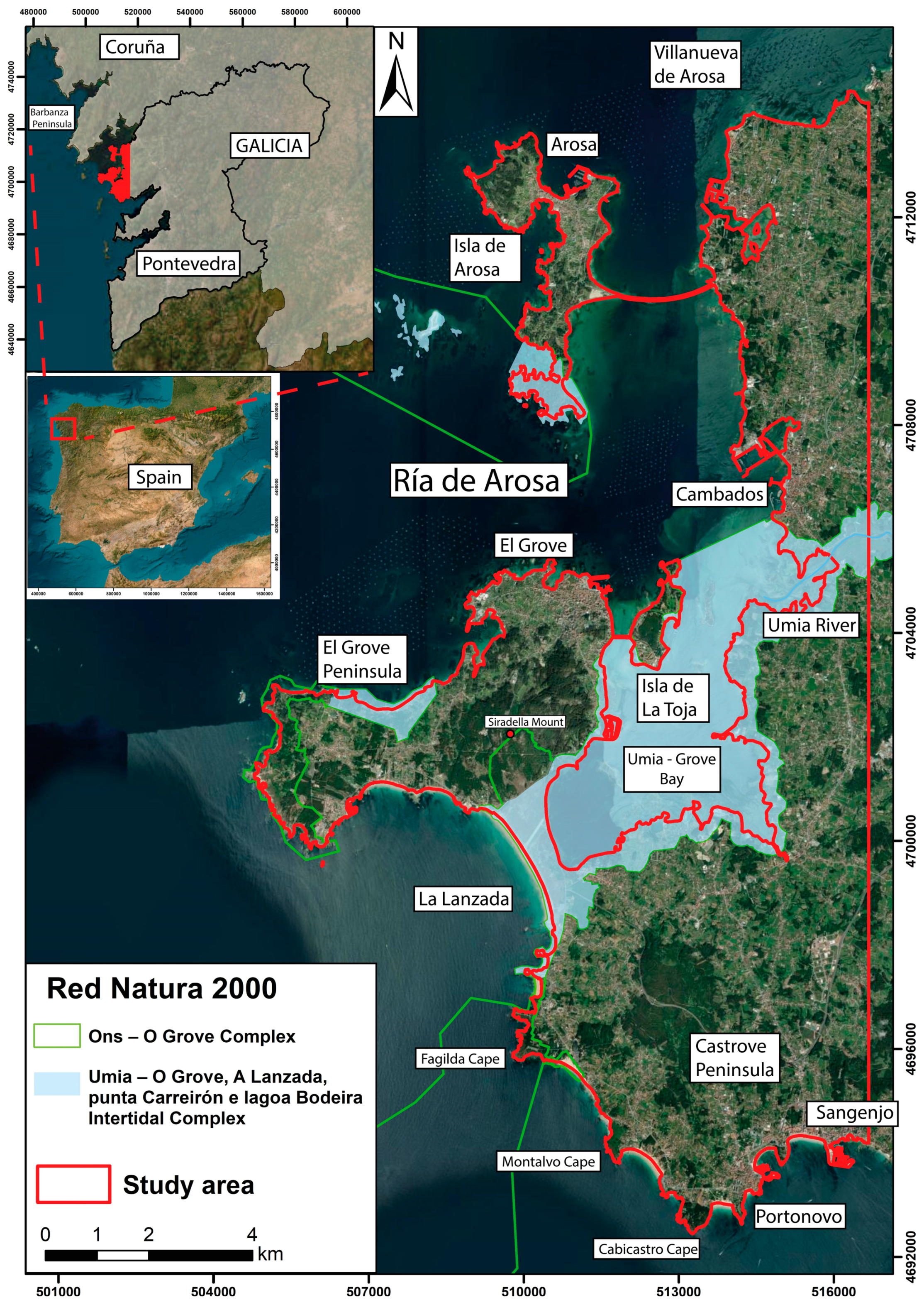
Study Area
2. Materials and Methods
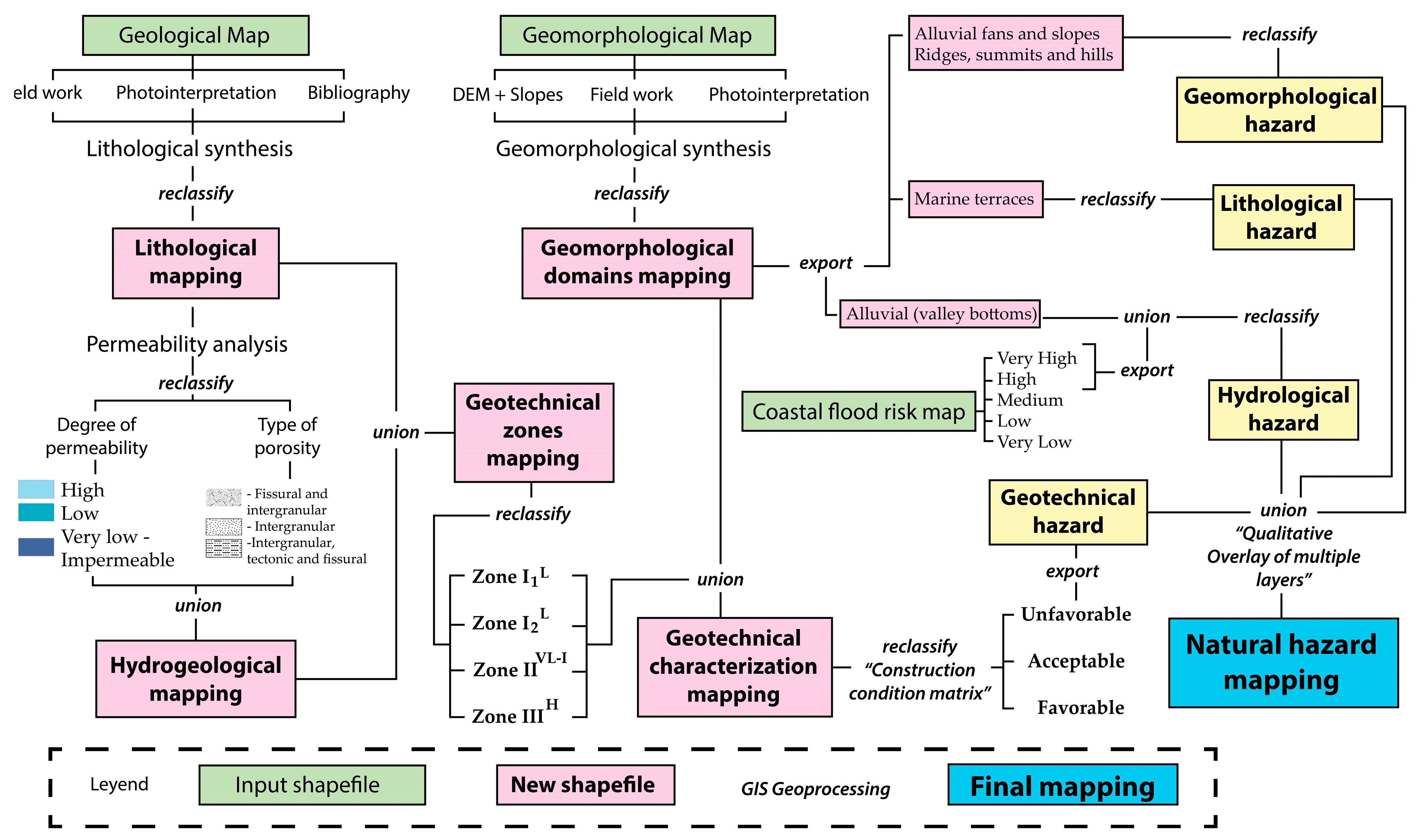
2.1. Geotechnical Characterization Mapping
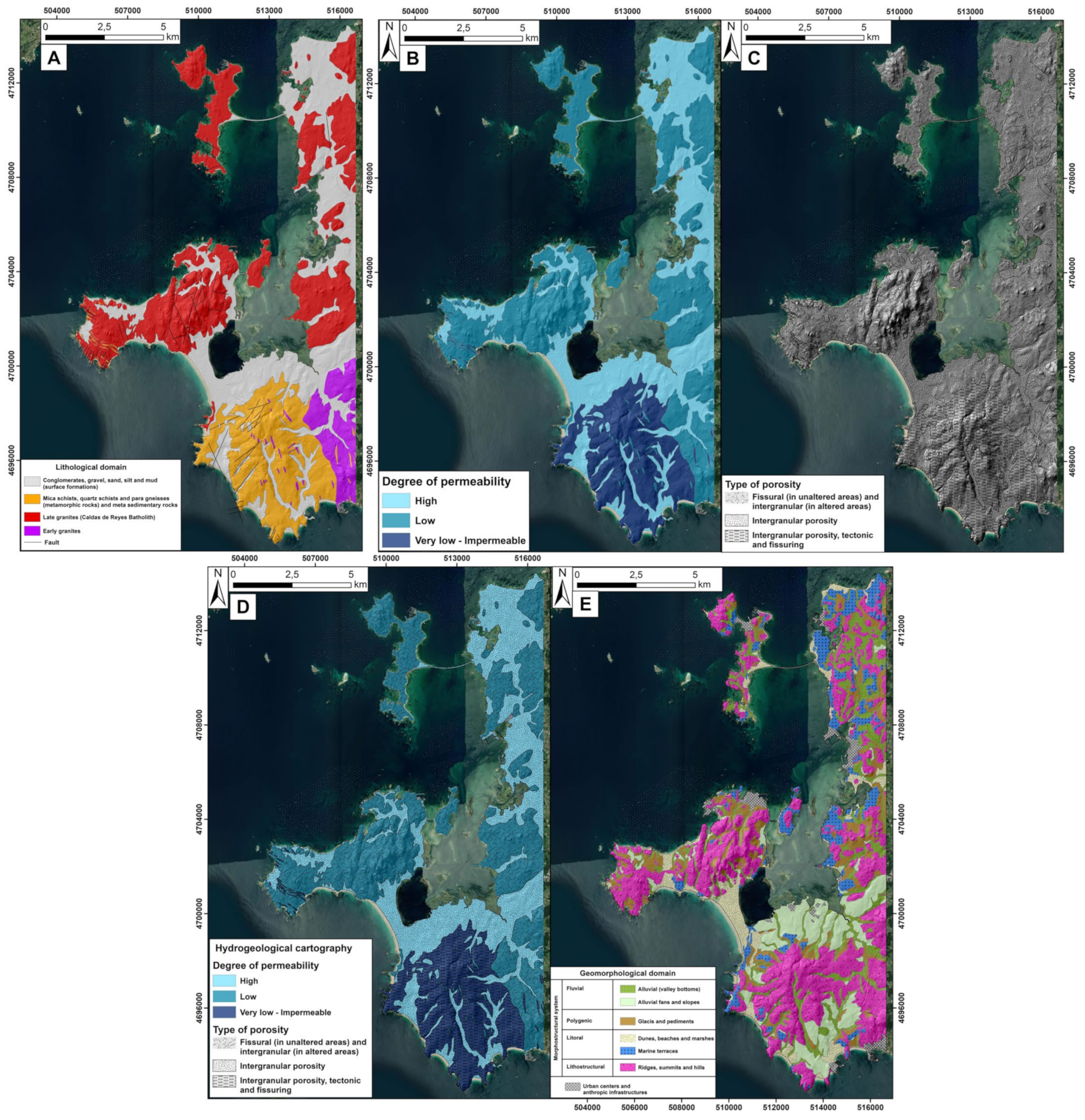
- Lithological Mapping: This map starts with a geological map of the area [45,46,47,48], which is simplified by grouping lithologies based on compositional, textural, or geomechanical similarities. Each group defines the homogeneous lithological units that will make up the geotechnical characterization mapping. In this case, lithological groups from Quaternary surface formations are differentiated and reclassified into various lithological domains.
- Hydrogeological Mapping: Creating the hydrogeological map requires combining data sources and criteria from fieldwork with filtered information from the creation of the lithological map. Hydrogeological data primarily come from official cartography from the Spanish Geological and Mining Institute (IGME) and digital information from the Galician Health Service (https://www.sergas.es/Saude-publica/GIS-Litoloxia-xeoloxia, accessed on 31 October 2024). These data include the hydraulic properties of the different lithological formations. After characterizing lithological units with similar hydraulic properties, hydrogeological units are described. These hydrogeological units are defined based on their permeability degree (from impermeable to very permeable) and porosity type (intergranular, fissure, tectonic, or alteration). These characteristics are intrinsic to each type of rock or substrate. Crystalline rocks, which compose the Variscan basement (igneous and metamorphic), generally exhibit low or no permeability, a characteristic influenced by the low or null effective porosity of these lithologies, allowing water to pass through fractures, joints, or tectonic plates (schistosity). The igneous rocks (granitoids, granodiorites) and metamorphic rocks (slates and schists) found in the study area exhibit these hydrogeological behaviors [45,46,47,48]. The substrate belonging to Quaternary surface formations, which shows little or no consolidation, has very different hydrogeological characteristics. Its high effective porosity, which is of an intergranular type, leads to very high permeability values. However, there are no areas with significant thicknesses that would prevent the formation of aquifers with high water-capturing potential in the territory [45,46,47,48]. Each hydrogeological unit is assigned a color based on its permeability level for proper differentiation. In this case, the different units are represented in blue tones, with intensity varying according to their permeability level. The darkest color represents very high and impermeable values, which become lighter as permeability increases. In addition, each porosity type is differentiated by a characteristic transparent pattern. Both layers, formed by the reclassification of lithological domains, are combined to create the hydrogeological map.
- Geotechnical Zone Mapping: The vector polygons from the lithological and hydrogeological maps are merged, and, through a reclassification of the resulting polygons, different geotechnical zones are determined. In this case, the geotechnical zones are numbered with Roman numerals (I, II, III, …). Each represents a lithological type with specific hydraulic properties (porosity). This leads to the creation of the geotechnical zone mapping.
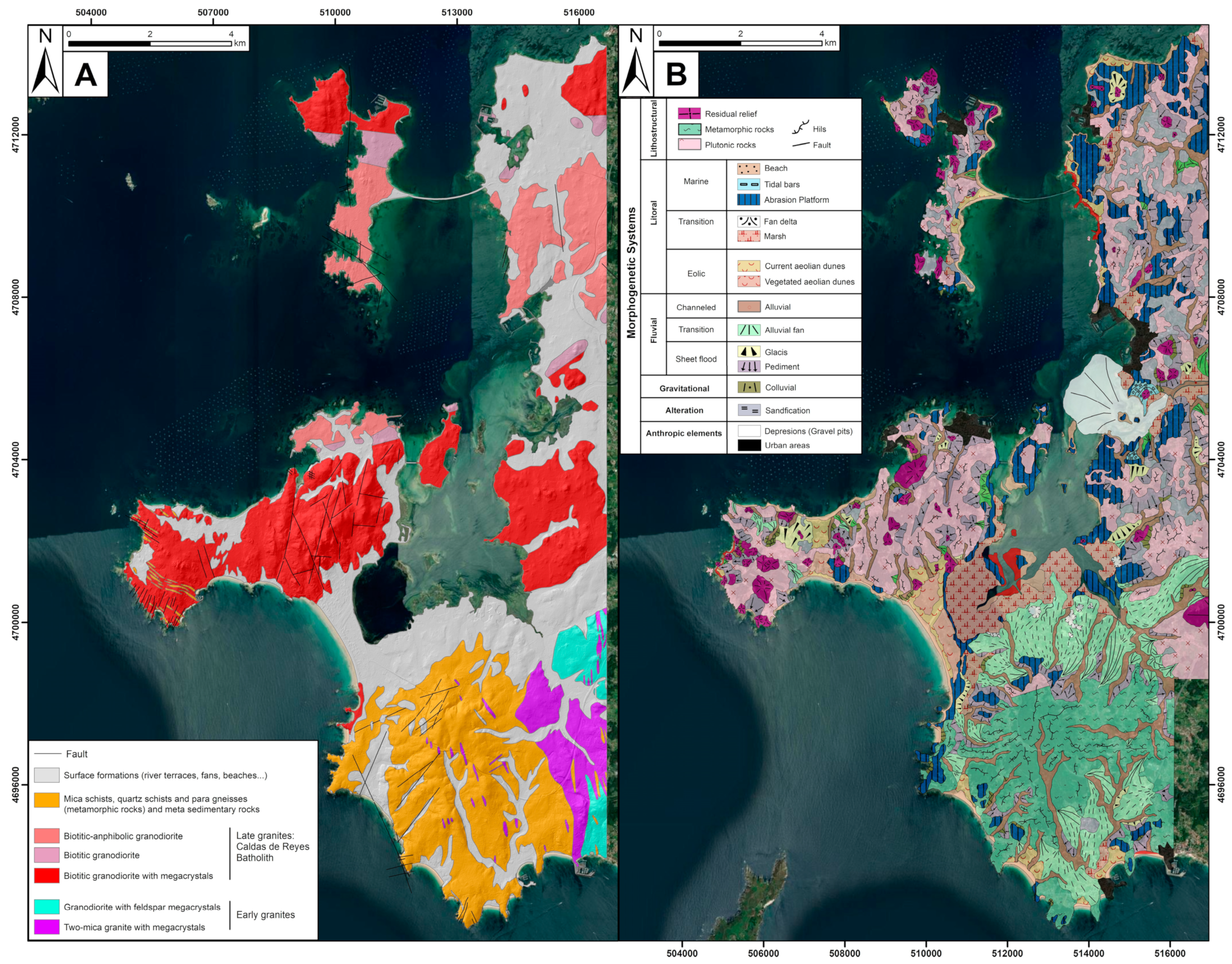
- Geomorphological Domain Mapping: This is derived from the detailed geomorphological map, with a resolution of 1:50,000 for the study area [49]. This type of mapping encompasses the fundamental features of the reliefs, synthesizing them. This simplification requires an in-depth relief analysis, relying on the slope map, DEM, specific fieldwork, and photointerpretation. Its purpose is to facilitate an understanding of the terrain and highlight its physiographic characteristics, which are grouped into morphogenetically coherent domains independent of the substrate type, though the substrate type often influences the morphological appearance of the relief.
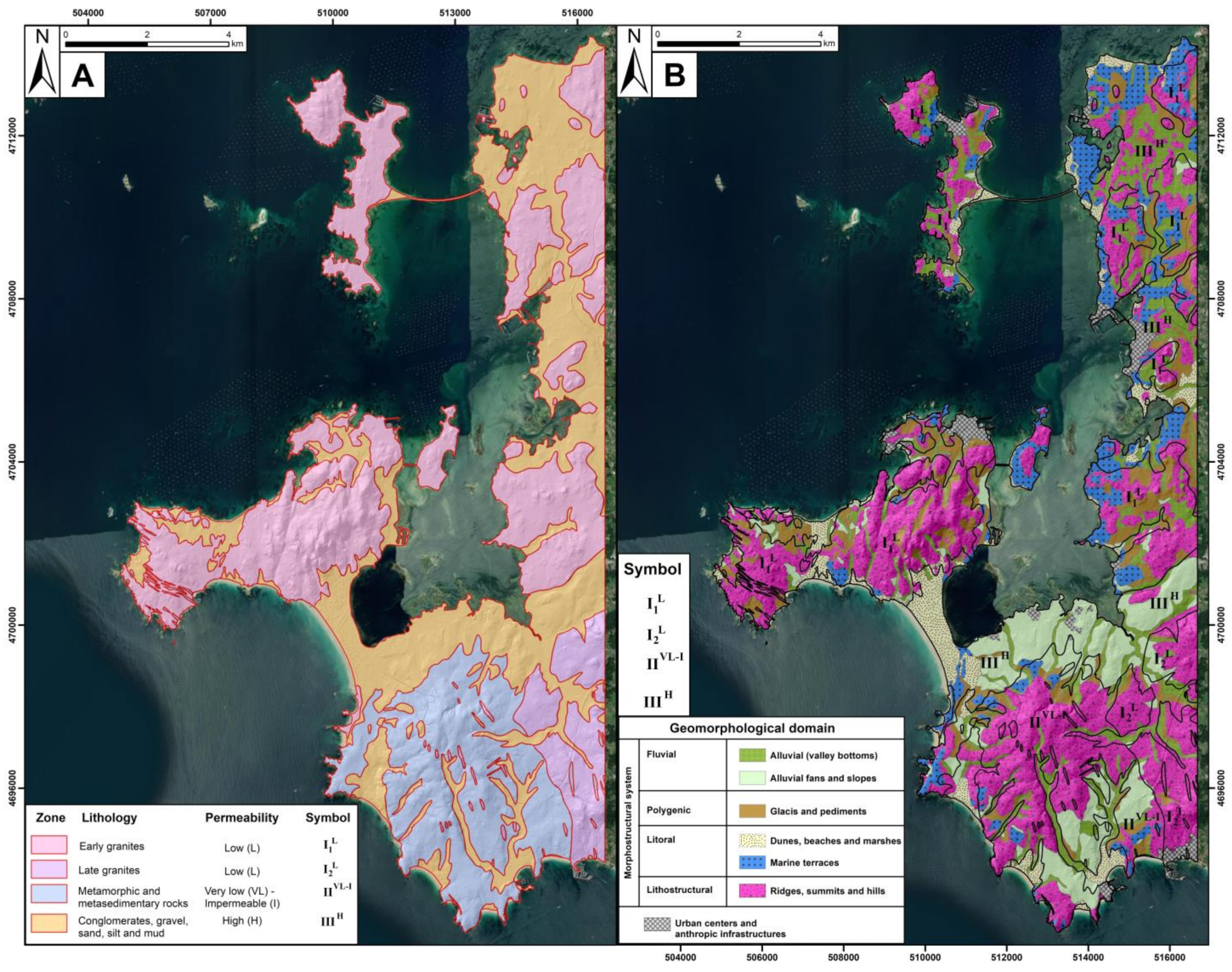
- Geotechnical Characterization Mapping: The combined polygons generated from the geotechnical zone mapping and the geomorphological domain mapping create a 1:50,000 geotechnical characterization map for the southeastern margin of the Ría de Arosa. This map presents both the geotechnical properties of the substrate and the surface formations on it, enabling the identification of areas with limitations or negative triggers for civil engineering, urban, or industrial activities.
2.2. Natural Hazard Mapping
- Lithological hazards: These relate to the textural, structural, and compositional characteristics of each lithology. Processes such as karstification and the resulting consequences for carbonate rocks, the planes of weakness seen in some lithologies, or degrees of consolidation represent risks associated with this type of hazard. In our case, the main lithological issues are associated with poorly cemented conglomerate deposits found on terrace or marine “rasas” formations. These polygons are derived from the geomorphological domain map, exported, and reclassified as lithological hazards.
- Geomorphological hazards: Each geomorphological feature impacts the terrain’s construction conditions differently. In these cases, natural or predominantly anthropogenic action can induce instability in certain surface formations. Generally, areas with steeper slopes will have a less favorable response in terms of stability, potentially triggering active gravitational processes like landslides, rockfalls, or soil creep. In the study area, ridges, hills, and summits, with their steep slopes and occasional presence of granite boulders, which may cause instability during construction, are classified as geomorphological hazards. Alluvial fans and gentler slopes also pose risks to stability during construction phases and are classified similarly.
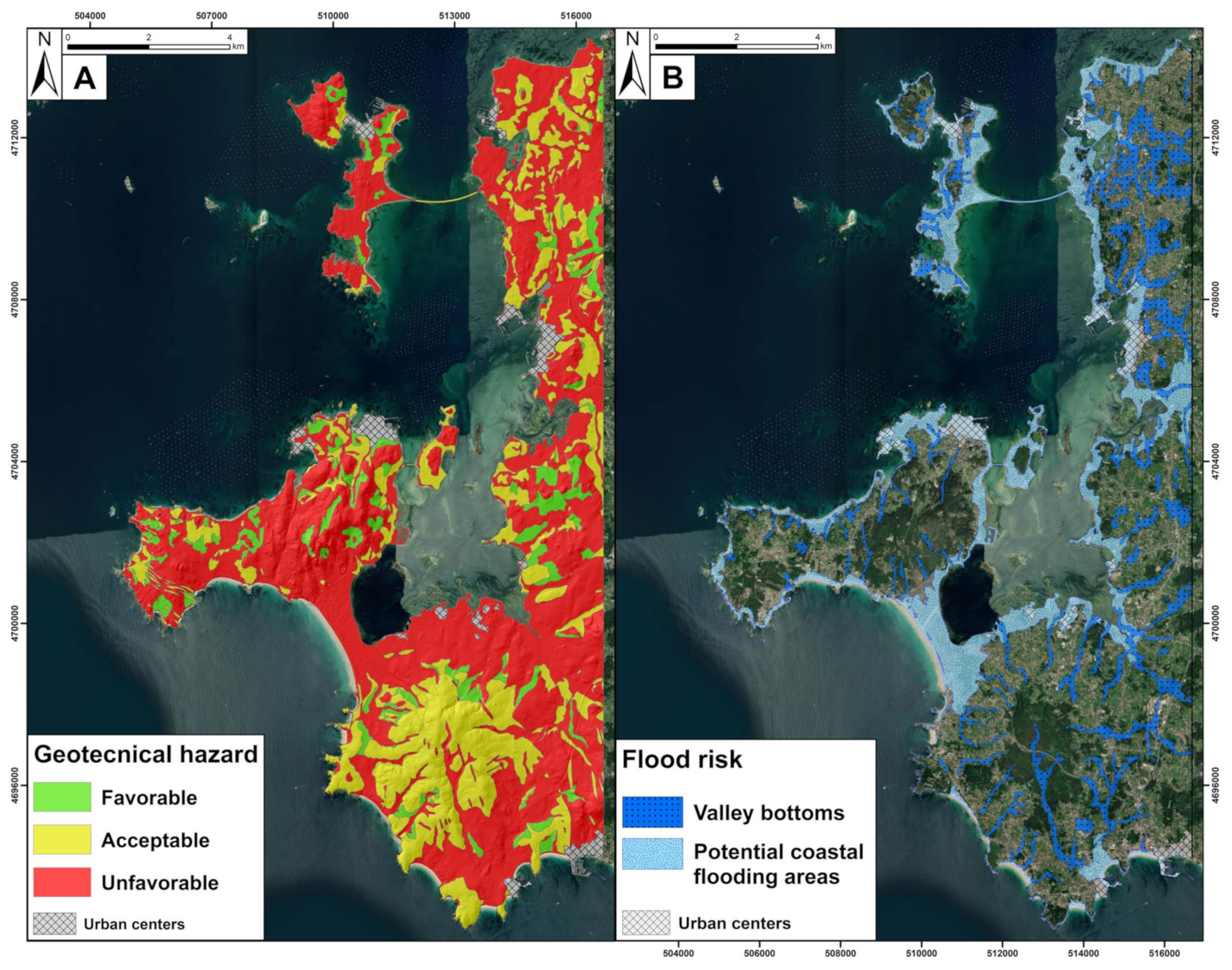
- Hydrological hazards: The identification of high-risk flood areas is based on integrating coastal flood risk data with a geomorphological analysis to delimit and describe valley floors. Coastal flood risk maps for the southeastern margin of the Ría de Arosa were created using the Flood Hazard Index (FHI) method, which has been successfully applied to areas on the Atlantic margin of the Iberian Peninsula [28]. The parameters analyzed include significant wave height (Fw), annual sea level rise (Fsl), and extreme tidal range (Ftr), which were obtained from public data on PORTUS (Spanish Ports) (https://portus.puertos.es/#/, accessed on 31 October 2024). The rate of sea level rise (mm/year) is considered a variable factor, with values based on extreme scenarios presented by the Intergovernmental Panel on Climate Change (IPCC), where greater increase rates are expected [5]. A raster layer is created from the digital elevation model (DEM), with pixels below the maximum water sheet level for each scenario selected. The higher-risk scenarios Xa and Xb, at 25 and 100 years, respectively, are extracted in order to be included in the flood risk mapping, a part of the natural hazard mapping. Geomorphological data of the area were used to identify alluvial deposits in the valley floors, regarded as flood-prone zones. These deposits, characterized by a low altitude and proximity to fluvial systems, were highlighted as hydrological vulnerability areas. Both maps were combined and used to reclassify hydrological hazards.
- Geotechnical hazards: The geotechnical characterization map results allow for the identification of favorable, acceptable, or unfavorable areas for active construction processes. Each polygon is evaluated using a construction conditions matrix that crosses geotechnical zones (described in the geotechnical zone mapping) with geomorphological domains. As a result, polygons with unfavorable values are exported and reclassified as geotechnical hazards.
3. Results and Discussion
3.1. Geotechnical Characterization
3.1.1. Lithological Mapping
3.1.2. Hydrogeological Mapping
3.1.3. Geomorphological Domain Mapping
3.1.4. Geotechnical Zones and Geotechnical Characterization Mapping
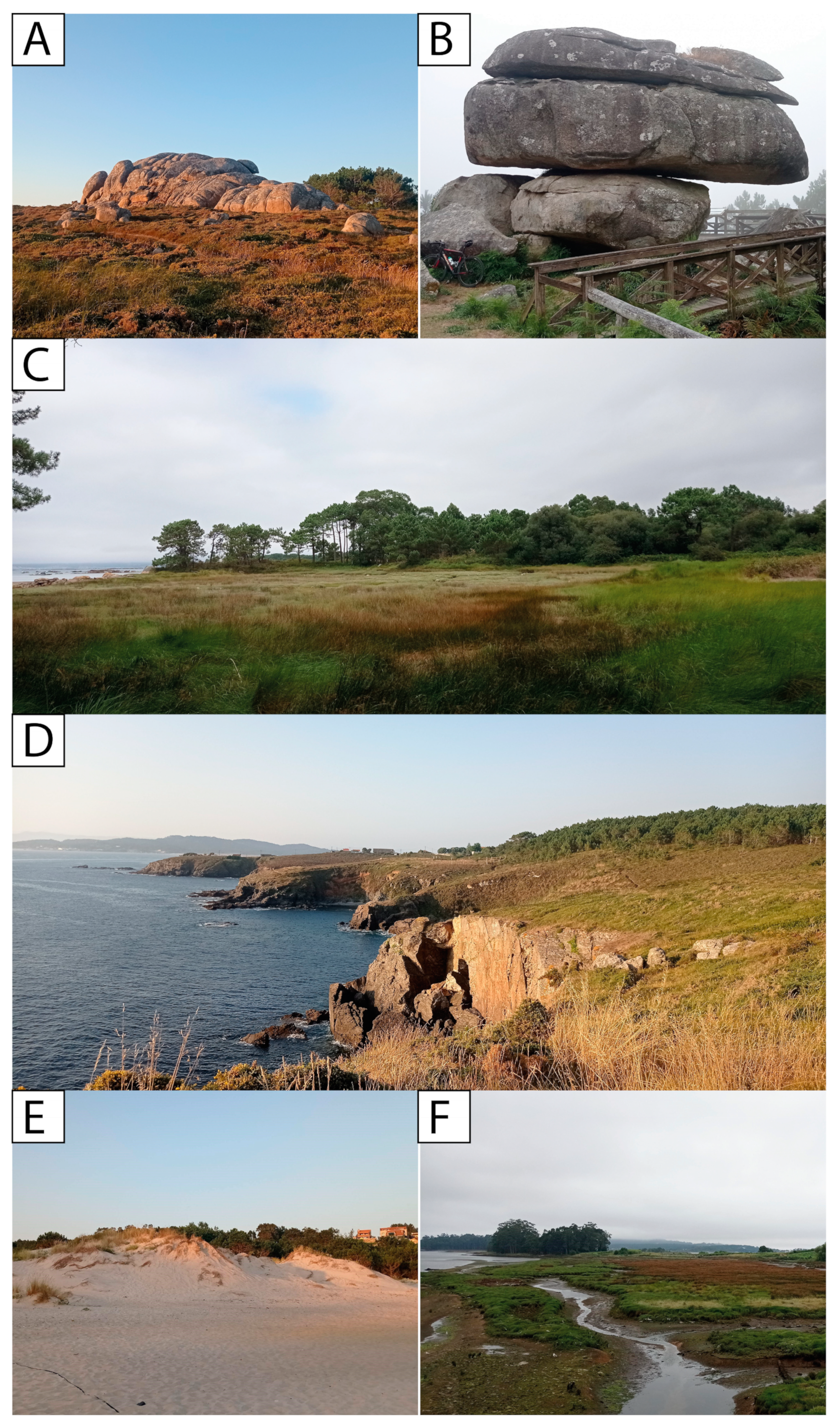
- Zone I1L: This zone exhibits a varied distribution and is prominently present in the El Grove Peninsula and the NE sector of the ría coastline. It occupies almost the entirety of the islands of Arosa and La Toja. Its presence around Punta Lanzada, on the NW margin of the Castrove Peninsula, is also notable. Lithologically, it corresponds to Caldas de Reyes granodiorite, which shows a slightly higher permeability than earlier facies (Figure 5A). This is particularly evident in tectonized areas, where fractures and weathering promote percolation processes and the development of minor aquifers. This area is well-defined by its residual litostructural relief, characterized by systems of summits, hills, and crests. In specific locations where the slopes are steeper, such as in the interior of the El Grove Peninsula or the northern sector of Arosa Island, dome-like morphologies or more mature rocky outcrops are visible (Figure 6A,B). Colluvium, along with pediments and glacis, is well represented in areas with more pronounced slope changes. Coastal environments make up the “marine rasas” (terraces) that show a smoothing of the relief, with almost nonexistent slopes (Figure 5B and Figure 6C).
- Zone I2L: Located on the S–SE margin of the study area, this zone is entirely represented by early granite facies that are affected internally by tectonic deformation processes. This area shows very low permeability conditions that increase slightly where weakness planes (fracturing or jointing) are concentrated or where there is a high degree of alteration (Figure 5A). The relief structures distinguished here are part of the regional modeling of granite, creating a residual relief where, in some cases, domed structures stand out (Figure 5B).
- Zone IIVL–I: This zone is found in the inner sector and SW margin of the Castrove Peninsula, where significant cliff areas are highlighted (Punta Fagilda, Punta de Cabicastro) (Figure 6D). Lithologically composed of metamorphic rocks (schists, gneisses) belonging to the “d’Home–La Lanzada Complex”, these rocks show very low, almost impermeable, permeability values, with exceptions in sectors with a greater development of tectonic plates (schistosity) and higher concentrations of fractures and joint systems (Figure 5A). Geomorphologically, the inner areas where slopes are slightly steeper represent residual litostructural reliefs, primarily defined by hills and summits. In the southern zone, more gentle alluvial fans and cones have developed. The area closest to the coast contains some rasas (Figure 5B and Figure 6D).
- Zone IIIH: This zone has a heterogeneous distribution throughout the study area. The places where it is best recognized are in the Tombolo of La Lanzada and the N zone of the Castrove Peninsula, where the most significant alluvial fan systems are located. Composed of a substrate with a low or nonexistent consolidation of superficial formations, it has high permeability due to its high porosity (Figure 5A). Important coastal deposits such as dunes, beaches, or marsh areas are within this zone, as in the case of the Umia River mouth (Figure 6E,F). The poorly evolved drainage network of the territory also demonstrates the presence of alluvial bottoms. Significant rasas are identified in areas near the coast with very gentle slopes (Figure 5B).
3.2. Natural Hazards
3.2.1. Geotechnical Hazard Map
3.2.2. Hydrological Hazard Map
3.2.3. Natural Hazards Mapping
4. Conclusions
Author Contributions
Funding
Institutional Review Board Statement
Informed Consent Statement
Data Availability Statement
Acknowledgments
Conflicts of Interest
References
- Martínez, M.L.; Intralawan, A.; Vázquez, G.; Pérez–Maqueo, O.; Sutton, P.; Landgrave, R. The Coasts of Our World: Ecological, Economic and Social Importance. Ecol. Econ. 2007, 63, 254–272. [Google Scholar] [CrossRef]
- Adger, W.N.; Hughes, T.P.; Folke, C.; Carpenter, S.R.; Rockstrom, J. Social–Ecological Resilience to Coastal Disasters. Science 2005, 309, 1036–1039. [Google Scholar] [CrossRef] [PubMed]
- Jin, X.; Luan, W.; Yang, J.; Yue, W.; Wan, S.; Yang, D.; Xiao, X.; Xue, B.; Dou, Y.; Lyu, F.; et al. From the Coast to the Interior: Global Economic Evolution Patterns and Mechanisms. Humanit. Soc. Sci. Commun. 2023, 10, 723. [Google Scholar] [CrossRef]
- Li, K.; Zhang, L.; Chen, B.; Zuo, J.; Yang, F.; Li, L. Analysis of China’s Coastline Changes during 1990–2020. Remote Sens. 2023, 15, 981. [Google Scholar] [CrossRef]
- Lee, H.; Calvin, K.; Dasgupta, D.; Krinner, G.; Mukherji, A.; Thorne, P.; Trisos, C.; Romero, J.; Aldunce, P.; Barret, K. IPCC 2023: Climate Change 2023: Synthesis Report, Summary for Policymakers. In Contribution of Working Groups I, II and III to the Sixth Assessment Report of the Intergovernmental Panel on Climate Change; CoreWriting Team, Lee, H., Romero, J., Eds.; IPCC: Geneva, Switzerland, 2023. [Google Scholar]
- Brown, K.; Turner, R.K.; Hameed, H.; Bateman, I. Environmental Carrying Capacity and Tourism Development in the Maldives and Nepal. Environ. Conserv. 1997, 24, 316–325. [Google Scholar] [CrossRef]
- O’Brien, K.; Leichenko, R.; Kelkar, U.; Venema, H.; Aandahl, G.; Tompkins, H.; Javed, A.; Bhadwal, S.; Barg, S.; Nygaard, L.; et al. Mapping Vulnerability to Multiple Stressors: Climate Change and Globalization in India. Glob. Environ. Change 2004, 14, 303–313. [Google Scholar] [CrossRef]
- Bathrellos, G.D.; Gaki–Papanastassiou, K.; Skilodimou, H.D.; Papanastassiou, D.; Chousianitis, K.G. Potential Suitability for Urban Planning and Industry Development Using Natural Hazard Maps and Geological–Geomorphological Parameters. Environ. Earth Sci. 2012, 66, 537–548. [Google Scholar] [CrossRef]
- Skilodimou, H.D.; Bathrellos, G.D.; Chousianitis, K.; Youssef, A.M.; Pradhan, B. Multi–Hazard Assessment Modeling via Multi–Criteria Analysis and GIS: A Case Study. Environ. Earth Sci. 2019, 78, 47. [Google Scholar] [CrossRef]
- Bender, S. Primer on Natural Hazard Management in Integrated Regional Development Planning; Organization of American States, Department of Regional Development and Environment; Executive Secretariat for Economic and Social Affairs: Washington, DC, USA, 1991. [Google Scholar]
- Alexander, D. Natural Disasters; Routledge: London, UK, 2018. [Google Scholar]
- Mileti, D. Disasters by Design: A Reassessment of Natural Hazards in the United States; Joseph Henry Press: Washington, DC, USA, 1999. [Google Scholar]
- Adger, W.N. Vulnerability. Glob. Environ. Change 2006, 16, 268–281. [Google Scholar] [CrossRef]
- Cutter, S.L.; Barnes, L.; Berry, M.; Burton, C.; Evans, E.; Tate, E.; Webb, J. A Place–Based Model for Understanding Community Resilience to Natural Disasters. Glob. Environ. Change 2008, 18, 598–606. [Google Scholar] [CrossRef]
- Burby, R.J.; May, P.J. Making Governments Plan: State Experiments in Managing Land Use; JHU Press: Baltimore, MD, USA, 1997. [Google Scholar]
- Godschalk, D.R. Urban Hazard Mitigation: Creating Resilient Cities. Nat. Hazards Rev. 2003, 4, 136–143. [Google Scholar] [CrossRef]
- UNISDR. Hyogo Framework for Action 2005–2015; United Nations International Strategy for Disaster Reduction: Geneva, Switzerland, 2007. [Google Scholar]
- UNDRR. Sendai Framework for Disaster Risk Reduction 2015–2030; United Nations Office for Disaster Risk Reduction: Geneva, Switzerland, 2015. [Google Scholar]
- Safani, J.; Matsuoka, T. Soft–Geotechnical Zone Determination Using Surface–Wave for Geotechnical Hazard Mitigation. Procedia Environ. Sci. 2013, 17, 354–360. [Google Scholar] [CrossRef]
- Haeri, S.M. The Role of Geotechnical Engineering in Sustainable and Resilient Cities. Sci. Iran. 2016, 23, 1658–1674. [Google Scholar] [CrossRef]
- EU. Council Directive 92/43/EEC on the conservation of natural habitats and of wild fauna and flora. Off. J. Eur. Union 1992, 206, 7–50. [Google Scholar]
- Álvarez–Vázquez, M.Á.; González–Prieto, S.J.; Prego, R. Possible Impact of Environmental Policies in the Recovery of a Ramsar Wetland from Trace Metal Contamination. Sci. Total Environ. 2018, 637–638, 803–812. [Google Scholar] [CrossRef]
- Austin, D.E. Coastal Exploitation, Land Loss, and Hurricanes: A Recipe for Disaster. Am. Anthropol. 2006, 108, 671–691. [Google Scholar] [CrossRef]
- Mohammed, S.; Abdo, H.G.; Szabo, S.; Pham, Q.B.; Holb, I.J.; Linh, N.T.T.; Anh, D.T.; Alsafadi, K.; Mokhtar, A.; Kbibo, I.; et al. Estimating Human Impacts on Soil Erosion Considering Different Hillslope Inclinations and Land Uses in the Coastal Region of Syria. Water 2020, 12, 2786. [Google Scholar] [CrossRef]
- Gill, J.C.; Malamud, B.D. Hazard Interactions and Interaction Networks (Cascades) within Multi–Hazardmethodologies. Earth Syst. Dynam. 2016, 7, 659–679. [Google Scholar] [CrossRef]
- Gallina, V.; Torresan, S.; Critto, A.; Sperotto, A.; Glade, T.; Marcomini, A. A Review of Multi–Risk Methodologies for Natural Hazards: Consequences and Challenges for a Climate Change Impact Assessment. J. Environ. Manag. 2016, 168, 123–132. [Google Scholar] [CrossRef]
- Zschau, J. Where Are We with Multihazards, Multirisks Assessment Capacities? European Union: Maastricht, The Netherlands, 2017. [Google Scholar]
- Nieto, C.E.; Martínez–Graña, A.M.; Encinas, B. Analysis of the Risk of Coastal Flooding Due to Rising Sea Levels in Ría of Arosa (Pontevedra, Spain). Appl. Sci. 2023, 13, 12099. [Google Scholar] [CrossRef]
- Nieto, C.E.; Martínez-Grana, A.M.; Merchán, L. Soil Erosion Risk Analysis in the Ría de Arosa (Pontevedra, Spain) Using the RUSLE and GIS Techniques. Forests 2024, 15, 1481. [Google Scholar] [CrossRef]
- Martínez-Graña, A.M.; Goy, J.L.; Zazo, C. Peligrosidad Natural en el Espacio Protegido de las Batuecas–S Francia, Quilamas y su entorno (Salamanca). Análisis integrado de los factores potenciales de riesgo. Geogaceta 2004, 36, 71–74. [Google Scholar]
- Merchán, L.; Martínez-Graña, A.M.; Nieto, C.E.; Criado, M. Natural Hazard Characterisation in the Arribes del Duero Natural Park (Spain). Land 2023, 12, 995. [Google Scholar] [CrossRef]
- Gornitz, V. Global Coastal Hazards from Future Sea Level Rise. Palaeogeogr. Palaeoclimatol. Palaeoecol. 1991, 89, 379–398. [Google Scholar] [CrossRef]
- Kunte, P.D.; Jauhari, N.; Mehrotra, U.; Kotha, M.; Hursthouse, A.S.; Gagnon, A.S. Multi–Hazards Coastal Vulnerability Assessment of Goa, India, Using Geospatial Techniques. Ocean. Coast. Manag. 2014, 95, 264–281. [Google Scholar] [CrossRef]
- Gigović, L.; Pamučar, D.; Bajić, Z.; Milićević, M. The Combination of Expert Judgment and GIS–MAIRCA Analysis for the Selection of Sites for Ammunition Depots. Sustainability 2016, 8, 372. [Google Scholar] [CrossRef]
- Stalhandske, Z.; Steinmann, C.B.; Meiler, S.; Sauer, I.J.; Vogt, T.; Bresch, D.N.; Kropf, C.M. Global Multi–Hazard Risk Assessment in a Changing Climate. Sci. Rep. 2024, 14, 5875. [Google Scholar] [CrossRef]
- Wu, H.; Shi, A.; Ni, W.; Zhao, L.; Cheng, Z.; Zhong, Q. Numerical simulation on potential landslide–induced wave hazards by a novel hybrid method. Eng. Geol. 2024, 331, 107429. [Google Scholar] [CrossRef]
- Cheng, K.; Ping, X.; Han, B.; Wu, H.; Liu, H. Study on particle loss-induced deformation of gap-graded soils: Role of particle stress. Acta Geotech. 2024, 1–28. [Google Scholar] [CrossRef]
- López Santiago, F. Mapa Geotécnico y de Peligrosidad Natural de la Ciudad de León y Su Aglomeración Urbana; ITGE: Madrid, Spain, 1991; p. 64. [Google Scholar]
- IGME. Mapa Geotécnico General E. 1:200.000, Pontevedra–La Guardia, Hoja 1–3/16, 1–4/26; Instituto Geológico y Minero de España, Servicio de Publicaciones Ministerio de Industria y Energía: Madrid, Spain, 1972. [Google Scholar]
- Chazarra Bernabé, A.; Lorenzo Marino, B.; Romero Fresneda, R.; Moreno García, J.V. Evolución de Los Climas de Koppen en España En El Periodo 1951–2020; Agencia Estatal de Meteorología: Madrid, Spain, 2022.
- Martín–Serrano, A. Macizo Hespérico Septentrional. In Geomorfología de España; Gutiérrez, M., Ed.; Rueda: Madrid, Spain, 1994; pp. 25–62. [Google Scholar]
- Llana–Fúnez, S.; Marcos, A. The Malpica–Lamego Line: A Major Crustal–Scale Shear Zone in the Variscan Belt of Iberia. J. Struct. Geol. 2001, 23, 1015–1030. [Google Scholar] [CrossRef]
- Bisdom, E.B.A. Micromorphology of a weathered granite near the Ria de Arosa (NW Spain). Leidse Geol. Med. 1967, 37, 33–67. [Google Scholar]
- Arps, C.E.S. Petrology of a part of the Western Galicia Basement between the río Jallas and the Ría de Arosa (NW Spain) with emphasis on zircon investigations. Leidse. Geol. Med. 1970, 46, 57–155. [Google Scholar]
- IGME. Mapa Geológico de Espana E. 1:50.000, Puebla de Caraminal, Hoja 151 (3–9), Segunda Serie—Primera Edición; Instituto Geológico y Minero de Espana, Servicio de Publicaciones Ministerio de Industria y Energía: Madrid, Spain, 1981. [Google Scholar]
- IGME. Mapa Geológico de Espana E. 1:50.000, Villagarcía De Arosa, Hoja 152 (4–9), Segunda Serie—Primera Edición; Instituto Geológico y Minero de Espana, Servicio de Publicaciones Ministerio de Industria y Energía: Madrid, Spain, 1982. [Google Scholar]
- IGME. Mapa Geológico de Espana E. 1:50.000, Grove, Hoja 184 (3–10), Segunda Serie—Primera Edición; Instituto Geológico y Minero de Espana, Servicio de Publicaciones Ministerio de Industria y Energía: Madrid, Spain, 1981. [Google Scholar]
- IGME. Mapa Geológico de Espana E. 1:50.000, Pontevedra, Hoja 185 (4–10), Segunda Serie—Primera Edición; Instituto Geológico y Minero de Espana, Servicio de Publicaciones Ministerio de Industria y Energía: Madrid, Spain, 1981. [Google Scholar]
- Martinez–Graña, A.M.; Arias, L.; Goy, J.L.; Zazo, C.; Silva, P. Geomorphology of the mouth of the Arosa estuary (Coruña–Pontevedra, Spain). J. Maps 2017, 13, 554–562. [Google Scholar] [CrossRef]
- Twidale, C.R. Granite Landforms; Elsevier: Amsterdam, The Netherlands, 1982. [Google Scholar]
- Calik, I.; Gurgun, A.P.; Ozcoban, M. Methods and Tools Used for Management of Geotechnical Risks in Construction Projects. Proc. Int. Struct. Eng. Constr. 2023, 10, 1–7. [Google Scholar] [CrossRef]

| Geomorphological Domains | Zone I1L | Zone I2L | Zone IIVL–I | Zone IIIH |
|---|---|---|---|---|
| Alluvial (valley bottoms) | Unfavorable | Unfavorable | Unfavorable | Unfavorable |
| Alluvial fans and slopes | Unfavorable | Unfavorable | Unfavorable | Unfavorable |
| Glacis and pediments | Favorable | Favorable | Favorable | Acceptable |
| Dunes, beaches, and marshes | Unfavorable | Unfavorable | Unfavorable | Unfavorable |
| Marine terraces | Acceptable | Acceptable | Acceptable | Unfavorable |
| Ridges, summits, and hills | Unfavorable | Unfavorable | Acceptable | Acceptable |
Disclaimer/Publisher’s Note: The statements, opinions and data contained in all publications are solely those of the individual author(s) and contributor(s) and not of MDPI and/or the editor(s). MDPI and/or the editor(s) disclaim responsibility for any injury to people or property resulting from any ideas, methods, instructions or products referred to in the content. |
© 2024 by the authors. Licensee MDPI, Basel, Switzerland. This article is an open access article distributed under the terms and conditions of the Creative Commons Attribution (CC BY) license (https://creativecommons.org/licenses/by/4.0/).
Share and Cite
Nieto, C.E.; Martínez-Graña, A.M.; Merchán, L. Natural Hazard Assessment in the Southeastern Margin of the Ría de Arosa (Pontevedra, Spain) Using GIS Techniques. Sustainability 2024, 16, 10101. https://doi.org/10.3390/su162210101
Nieto CE, Martínez-Graña AM, Merchán L. Natural Hazard Assessment in the Southeastern Margin of the Ría de Arosa (Pontevedra, Spain) Using GIS Techniques. Sustainability. 2024; 16(22):10101. https://doi.org/10.3390/su162210101
Chicago/Turabian StyleNieto, Carlos E., Antonio Miguel Martínez-Graña, and Leticia Merchán. 2024. "Natural Hazard Assessment in the Southeastern Margin of the Ría de Arosa (Pontevedra, Spain) Using GIS Techniques" Sustainability 16, no. 22: 10101. https://doi.org/10.3390/su162210101
APA StyleNieto, C. E., Martínez-Graña, A. M., & Merchán, L. (2024). Natural Hazard Assessment in the Southeastern Margin of the Ría de Arosa (Pontevedra, Spain) Using GIS Techniques. Sustainability, 16(22), 10101. https://doi.org/10.3390/su162210101


