Abstract
Herein, we propose new methods for interpreting the debris flow phenomena affecting the Sibillini Mountains (central Apennines, Italy), based on the main characteristics and mechanisms of these hazards and their associated risk, as studied by applying advanced GIS tools to a geodatabase including the morphometric parameters of many surveyed debris flows as well as topographic and climatic information. The study area is characterized by mainly calcareous lithologies belonging to the Umbria–Marche Succession, which are frequently covered by Quaternary continental deposits. Slopes and deep transversal valleys are strongly influenced by Pliocene–Quaternary tectonics. Our main objectives were (a) to provide a comprehensive survey of the local morphologies and dynamics of debris flows and localize, catalog, sample and implement them in a geodatabase, as well as monitor them; (b) to forecast potential future debris flows in the study area based upon their evolutionary processes (e.g., dynamic evolution of debris flows, time of recurrence, removed volume of materials) and, in doing so, evaluate hazards and risks for human activities, as well as possibly apply this prediction method to other areas with similar geological and morpho-climatic characteristics; and (c) to share scientific information with society, with the goal of involving citizens in a new and sustainable method of territorial management.
1. Introduction
From a geological point of view, a young country like Italy is characterized by dynamic phenomena whose effects give the landscape its extraordinary shapes. This is the reason why most of the beautiful sights in our country are considered extremely fragile and vulnerable.
In a new systemic approach, which is mainly focused on experimental and social research, we take into consideration two fundamental aspects: resources and risks. This approach, which is essentially linked to understanding the dynamics of the Earth and the consequent need for its adequate management, is centered on the interconnection between our planet and the populations of people that inhabit it. The trinomial comprising the individual, community and society aptly captures the complexity of the term “people” and serves as the common uniting factor.
The landscape can be considered one of the most important resources in our country, and it can be defined as the outcome of the interplay among physical, biotic and human components, operating within a spatial and temporal framework. According to the principles of the European Landscape Convention, the landscape significantly influences the quality of life, and it is society’s responsibility to safeguard natural landforms.
Risk, meanwhile, refers to exposure to a dangerous situation and implies a necessary personal decision on whether or not to avoid the danger. Explaining the concept of risk involves informing people about the natures and locations of hazards, the reasons behind their potential threats to lives, structures and infrastructure, their timing and, most importantly, the process by which a hazard transforms into a risk.
These reflections, although concise, allow us to understand how important it is to use a global approach and new perspectives to resolve related challenges, which increasingly, especially in a highly anthropized and globalized environment, impact the delicate society/environment balance.
Multi-scalarity, multi-temporality, multi-disciplinarity and integration should be the pillars of an approach that encompasses all disciplines related to both the planet and the societies that inhabit it. Simultaneously, it is crucial to effectively engage a community, so that individuals can be made aware of the conditions of their surrounding environment. One effective method of achieving this tricky goal is to launch an extensive information and awareness campaign, through which we may empower individuals, communities and society and encourage them to take part in territorial management.
2. Debris Flow Analysis of the Sibillini Mountains
The study area is located on the Adriatic side of the Sibillini Mountains, included in 1:50,000 scale sheets #324 and #325 of the Regional Technical Map (C.T.R.) of the Marche region. This paper, through an analysis of the main geomorphological characteristics of the debris flows affecting the Sibillini Mountain Range (central Apennines, Italy), evidences the hazards of these phenomena and the need to understand these phenomena as a risk for society and the landscape. The studied areas are included in the so-called “seismic crater” of the 2016–17 central Italy seismic crisis. In such a location, the integration of causes and effects often makes natural phenomena more harmful than expected. The destructive potential of natural phenomena is the result of the interaction between many factors, but above all, it derives from the risk hazards pose to lives and goods; the latter is a probabilistic factor of the possibility of a harmful event occurring in a certain area and during a certain period. When we consider its conditions, the study area is highly representative of the complex geo-morphodynamics characterizing certain Italian areas, particularly—in this case—the Apennines: beautiful, fragile landscapes.
In recent decades, rapid landslides (mainly debris flows) have occurred frequently in areas with high elevation differences, prompting increased interest in scientific research focused on gaining a deeper understanding of these phenomena. The significant damage they cause to artifacts, buildings and the landscape has also underscored their essential importance in territorial planning. Debris flows require a unique combination of factors to be activated. In addition to saturation and rainfall conditions, morphometric characteristics like a steep slope gradient and the thickness of debris cover, as well as the sedimentological and geotechnical properties of the materials involved, including permeability, mutual interlocking and shear strength, play a fundamental role in influencing the occurrence and movement of debris flows [1,2,3,4,5,6,7,8]. The phenomena in the Sibillini Mountains have been extensively studied, but their geomorphological dynamics have only recently come under investigation [9,10,11,12,13].
To begin filling the research gap, this study was carried out by applying GIS tools on a geodatabase containing the geometric and morphological parameters of the surveyed debris flows [14]. The geodatabase is composed of geographical information derived from the latest instruments, such as multiscale topographic maps (e.g., “Istituto Geografico Militare” 1:25,000 and “Carta Tecnica Regionale” 1:10,000), cartography maps of hydrogeological hazards and risks (e.g., “Piano di Assetto Idrogeologico”, “Inventario dei Fenomeni Franosi” and the archive of “Aree Vulnerate Italiane”) and multitemporal aerial images at different scales. Furthermore, the digital insights gained were deepened through the use of satellite imagery and detailed in-field surveys.
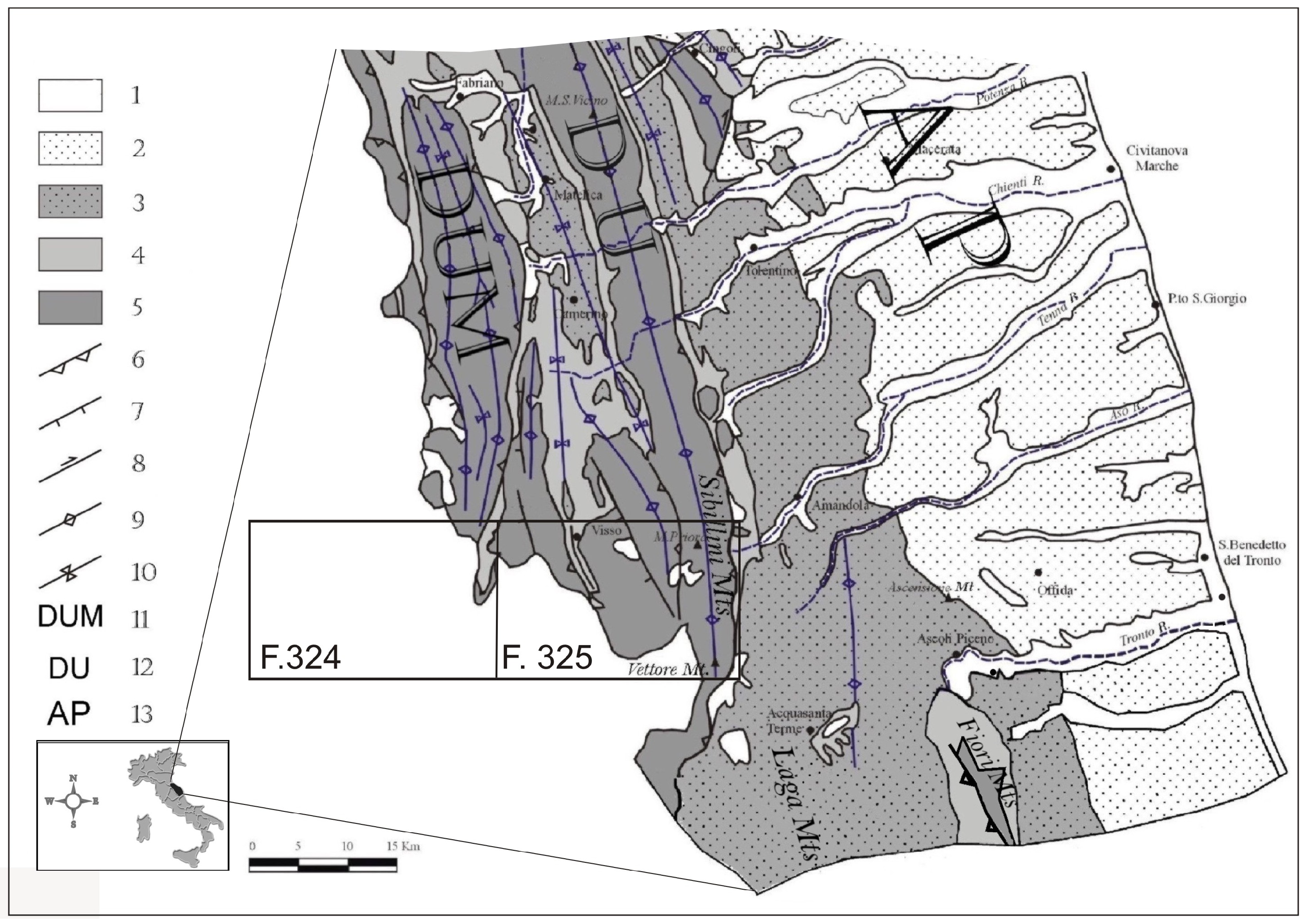
In sum, the Sibillini Mountain Range, where the highest elevation of the Umbria–Marche Apennines is reached (Figure 1), was investigated with the goal of describing certain parameters driving the occurrence of fast landslides or mass rapid processes. Historical research was also conducted in order to define the space and time framework of these phenomena, and geolithological analysis was performed to define the contribution of the tectonic arrangement [15,16].
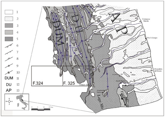
Figure 1.
Geological framework of the Marche–Abruzzi region. 1—Sands and gravels (Quaternary); 2—clays with intercalated sandstones and conglomerates (Lower Pliocene–Lower Pleistocene); 3—sandstones with intercalated clay (Upper–Middle Miocene); 4—marls, clayey marls and marly limestones (Upper Eocene–Upper Miocene); 5—limestones, cherty limestones with minor marls and clayey marls (Upper Trias–Middle Eocene); 6—overthrust; 7—normal faults; 8—strike–slip faults; 9—anticlines; 10—synclines; 11—Umbria–Marche Ridge; 12—Marche Ridge; 13—Peri-Adriatic area. The boxes F.324 and F.325 represent the study area.
Additionally, climatic time trends were thoroughly investigated so that we could make recommendations on the adequate governance of these mountain areas against a backdrop of climatic changes, with the goal being a reduction in natural risks.
Preliminary considerations were the effects of anthropization on the analyzed territory. Anthropization started in the 16th century, mainly along the Adriatic side of central Italy, with the advent of intense agro–forestry–pastoral activity, which extended into the following centuries. The anthropic impact of that activity has morphogenetic implications. For instance, widespread deforestation in mountain areas has frequently promoted the activation of rapid and intense erosive processes. These processes, reaching the regolith level, have made agricultural or pastoral activity impracticable, forcing the farmers to move to other areas where the same practices have been replicated [17]. Additionally, Holocene climatic variations [18] constitute a further important morphodynamic factor, particularly the so-called “Little Ice Age”, which, at times, caused the triggering of very important gravitational processes, many of which involved debris flows [14,17].
3. Materials and Methods
3.1. Main Physiographic Features of the Studied Area
The Sibillini Mountains Massif formed through the combination of the southern sections of the Umbria–Marche and Marche Ridges (Figure 1). Elevations vary from approximately 350 m (the deepest valley bottoms) to the height of 2476 m above sea level of Mt. Vettore, with numerous peaks surpassing 2000 m above sea level.
The landscape is characterized by deep and narrow valleys delimitated by large watersheds, with mostly rounded and parallel ridges and peaks; the elevation is mostly higher than 1000 m a.s.l. with slope angles generally exceeding 40% (commonly sub-vertical). The bedrock is made up of members of the well-known Umbria–Marche Succession (Upper Trias—Aquitanian p.p.). At its base, we find limestones (Calcare Massiccio), overlain by stratified limestones containing chert, marly limestones and marls. The sedimentary stratigraphic succession continues with a micritic limestone unit (Maiolica), followed by marly clays and marly limestones (Marne a Fucoidi) and then by marly calcareous units (group of the Scaglia Formations) [19,20].
The tectonic setting is defined by a fold and thrust system with eastern vergence. The compressive structural tectonic lineament that acted most effectively was the Sibillini thrust, which caused the overlapping of calcareous units above the terrigenous Miocene sedimentary formations of the foredeep [21,22,23]. These tectonic lineaments took shape starting from the Upper Messinian, where, thanks to compressive movements, the basin floor started to corrugate. NNW–SSE- and ENE–WSW-trending normal faults, related to an extensional phase active from the end of the Lower Pleistocene, markedly dissected the previous structures [19,20]. The most important structural lineaments, with an NNW–SSE trend, displaced blocks at different heights, also giving origin to intra-mountain depressions along the Apennines ridge [24,25]. Some of these intra-Apennine basins clearly show recent subsidence activity, as evidenced by the frequent and intense seismic events in these areas [25].
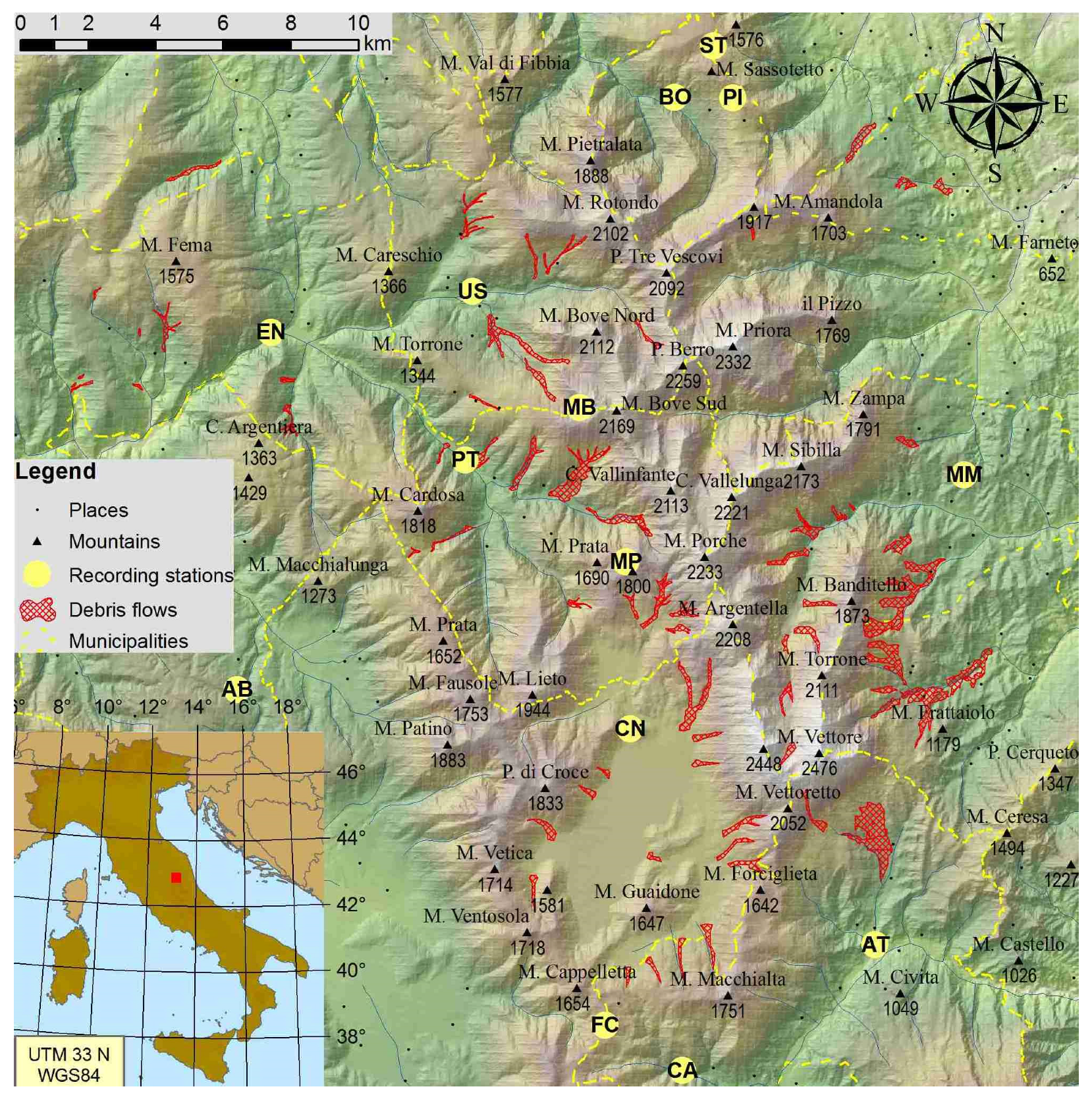
Superficial deposits of different genesis, thickness and extension (stratified or massive debris, moraines, fluvial–torrential deposits, landslide bodies and colluvial deposits) cover wide portions of the bedrock. Starting from the 16th century and progressively intensifying in the following centuries, deforestation and farming started to be practiced in the area. Anthropic actions led to significant impacts from a morphological point of view, in particular along the Adriatic side of the mountain massif. Extensive removal of trees on slopes led to rapid and intense erosion, often exposing the underlying soil and rendering the land unproductive. This, in turn, prompted farmers to clear more land for cultivation. The geomorphological changes in the landscape have also been influenced by the climate, especially during the period known as the Little Ice Age, which led to the initiation of large-scale gravity movements, specifically, debris flows [14,17]. Furthermore, current climate change is altering the temporal distribution of rainfall, creating an increase in extreme events in terms of frequency distribution and intensity. This trend suggests the need to start exploring different rainfall models to understand how and in what range the impact of climate change can influence the debris flow phenomenon. In Figure 2, the main and largest debris flows that have affected the Sibillini Mountain Range and the meteorological recording stations considered are illustrated.
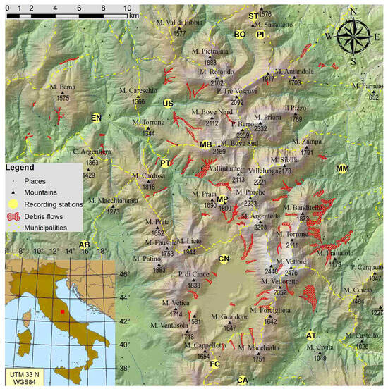
Figure 2.
Locations of the main debris flow phenomena considered in the Sibillini Mountains; in bold, the meteorological stations considered are indicated. BO: Bolognola; ST: Sassotetto; PI: Pintura; US: Ussita; EN: Endesa; PT: Ponte Tavola; MB: Monte Bove sud; MP: Monte Prata; AB: Abeto; CN: Castelluccio di Norcia; FC: Forca Canapine; CA: Capodacqua; AT: Arquata del Tronto; MM: Montemonaco.
3.2. Climate
In the study area, only a few acceptably long and continuous thermometric and pluviometric records are available: therefore, climate features cannot be accurately reconstructed. However, recently, the regional bodies of National Civil Protection have installed a few automatic recording stations, and some of those are located at high elevations (above 1500 m a.s.l.), where debris flows and snow avalanches are active.
For the climatic analyses, 14 recording stations were considered (Table 1 and Figure 2). Unfortunately, most had a very short recording timespan or had been relocated at least once (name in italics in Table 1), thus hampering our analyses of the time series [26].

Table 1.
Characterization of the available meteorological recording stations (for the locations, refer to Figure 2) (redrawn from [26]).
Statistical analysis of temperatures [26] resulted in the following values:
- Annual average temperatures ranged from 5.1 °C (Mount Bove Sud) to 12.3 °C (Ponte Tavola);
- Average temperatures in January ranged from −2.7 °C (Forca Canapine) to 3.5 °C (Montemonaco);
- Average temperatures in July ranged from 13.9 °C (M. Bove S.) to 20.3 °C (Montemonaco);
- Thermal amplitudes ranged between 15.5 °C (M. Bove S.) and 19.3 °C (Castelluccio di Norcia);
- Thermal excursions ranged between 7.7 °C and 12.8 °C.
The above results are fully compatible with the typical mountain climate of the central Apennines. Extrapolation of the climatic data using ESRI ArcGIS 11 allowed us to estimate an average annual temperature of 2.3 °C for the higher peaks, with a monthly average minimum and maximum of around −4 °C and 11 °C, respectively (thermal amplitude around 15 °C; thermal excursion about 6.7 °C).
The average annual precipitation showed relevant yearly fluctuations. Precipitation along ridges and peaks has likely often been severely underestimated due to the effect of wind: therefore, a correction factor was applied [26]. GIS-based interpolations (and extrapolations for higher elevations) allowed us to estimate the following [26]:
- Annual precipitation ranged between 850 mm along the valley bottoms and 1600 mm along ridges, where orographic precipitation frequently derived from both maritime temperate air masses (coming from the Atlantic/Mediterranean) and continental ones (coming from the NE);
- Rainy days varied from 90 along valleys to 130 at higher elevations.
The above precipitation regime, with an absolute seasonal maximum in autumn, a secondary maximum in spring and minimum values in summer and winter, is typical of the central Apennines [26,27,28]. While during winter, widespread and long-lasting frontal phenomena (often resulting in snowstorms) prevail, during summer, convective thunderstorms are more frequent, often deriving from the heating of intermountain basins. Therefore, unlike in the neighboring lower elevations, summer is not dry, since during the driest month (July), precipitation has always exceeded 50 mm. Moreover, there are generally no more than 20 consecutive dry days, even in the most protected valley bottoms, though during recent years, more long-lasting dry periods seem to have become more frequent.
Based on the above observations, according to the Köppen–Geiger classification in the study area, the climate varies from Cfc at lower elevations to H (similar to Dfc) above 2200 m.
Snowfalls are quite frequent and abundant, at least at elevations exceeding about 1200 m a.s.l. Records from snow fields collected since 1990 by the Meteomont service of the Corpo Forestale dello Stato at elevations ranging from 1000 to 1800 m a.s.l. [28] show that the average thickness of snow cover has varied from 150 cm to 270 cm, increasing with elevation. The number of snowy days (November to April) has varied from 10 to 35.
During the last decade, thunderstorms have become more frequent in autumn as a result of a significant increase in sea surface temperature in the Mediterranean [29]. Time series show a generalized increase in maximum snow thickness, while the persistence of snow cover has slightly decreased because of air warming during autumn and spring. Moreover, more frequent advection of sub-continental–tropical air increases the moistness of the snow; this, in turn, results in more recurring activation of both ground and surface avalanches in low-cohesion, wet snow, as well as faster ablation (causing more rapid saturation of the underlying permeable bodies) [30].
3.3. Technical Support
A recent study considered debris flows that have occurred in this study area (Figure 1), which were investigated via a detailed geomorphological survey of the phenomena paired with statistical analysis through GIS tools [14]. In this paper, we add to that work by providing further information to support an in-depth understanding of the phenomenology, as gained through an analysis of conditioning parameters characterizing different scenarios of debris flow and the related hazards. The collected data were compiled in an experimental inventory form containing each of the identified events. The completed form reports the various types of elements involved (i.e., geometric, morphological, dynamic, physical–mechanical characteristics), which are represented in different ways such as photos, evolutionary plans, geo-referenced maps and references to the local database.
The involved material was characterized through grain size analysis, conducted both in situ and, with greater precision, in the sedimentology and geotechnics laboratory. The sampling was performed in different portions of the debris flows.
In a recent detailed geomorphological survey of the study area, 180 debris flows were individuated and mapped at a 1:10,000 nominal scale (Figure 2). Moreover, more detailed elements were considered: the triggering factors of the debris flows, the areas of propagation of the events, the morphologies of catchment areas and the slopes potentially affected by the flows (including their slope angles), the thicknesses of potentially unstable deposits and, finally, the presence of avalanche channels and their interactions with debris flows.
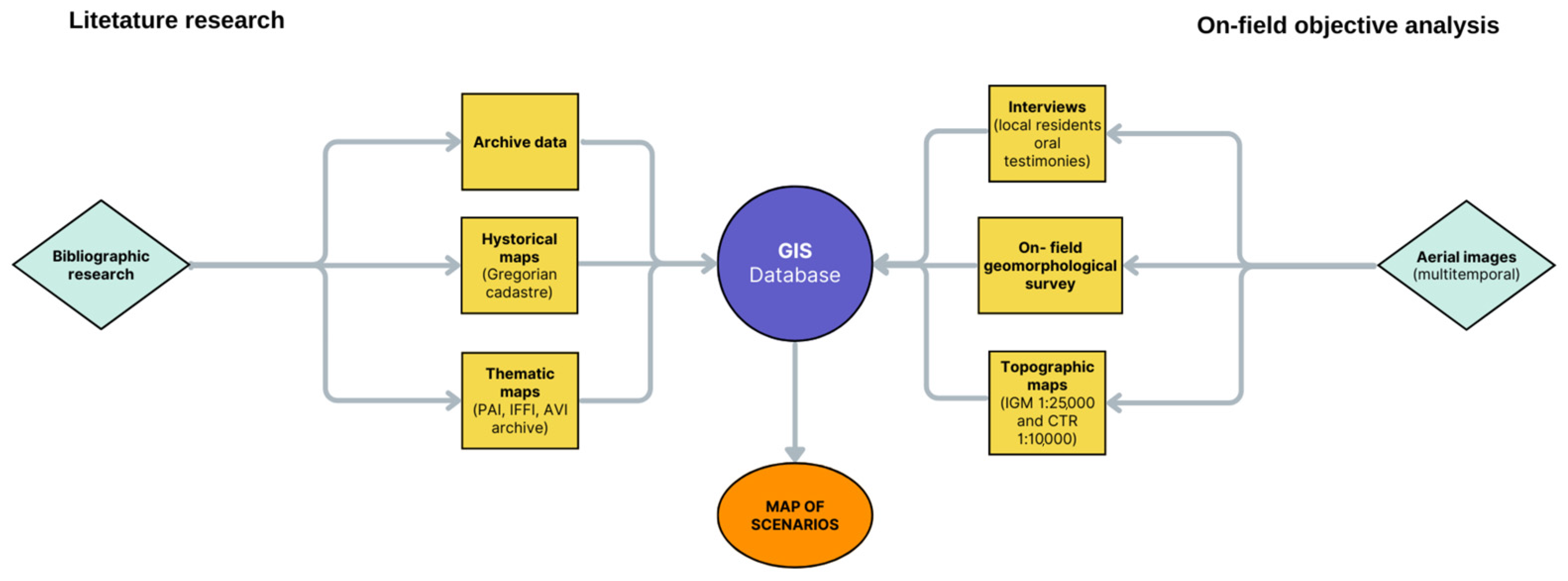
The methodology adopted was a multi-technique approach (Figure 3), combining literature research with in-field objective analysis that, at the end of this work, resulted in the production of a GIS database useful for scenario mapping. Our initial bibliographic search consisted of consulting archive data, historical maps (i.e., Gregorian cadaster) and thematic maps for the management of the hydrogeological and hydraulic risk (PAI “Hydrogeological Plan”, IFFI “Inventory of Italian Landslides Phenomena”, AVI archive “Vulnerated Areas Italian”). Based on this bibliographic and cartographic search and after a multitemporal study of aerial images, geomorphological field surveys were carried out. These were based on topographic technical maps at different scales and resolutions (also useful in recognizing major changes in the landscape and of the hydrographic network) and on interviews with residents. In relation to this work, it is necessary to specify that the collection of information from local elderly people was carried out quickly and intermittently because of the COVID-19 threat and lockdowns, which effectively prevented the regular and systematic conduct of interviews. An exception was the contact with some residents of the town of Rapegna, who recounted in detail the 1950 event that particularly affected the area of the municipalities of Castelsantangelo sul Nera and Visso (MC).
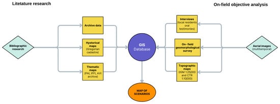
Figure 3.
Roadmap of this research.
This methodology led to the production of a GIS database in which all useful information is stored, and it allowed us to produce thematic maps of predicted scenarios, which are aimed at managing the hydrogeological risk from debris flows.
4. Analysis and Results
4.1. Geomorphological Characterization of Debris Flows
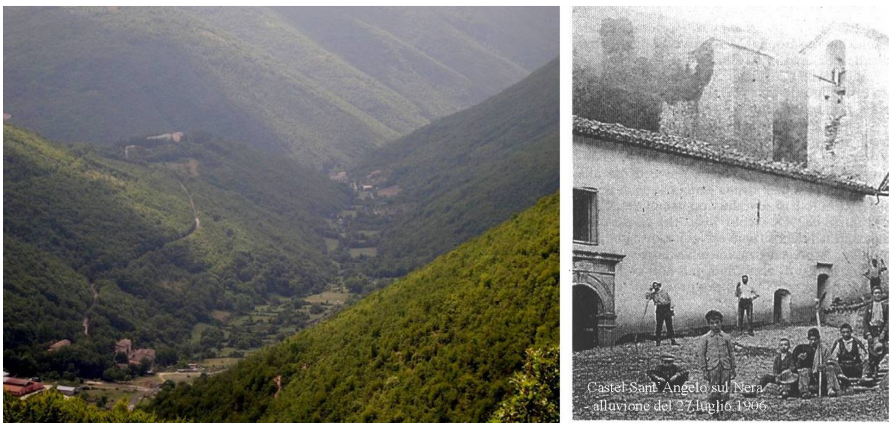
Debris flows usually develop along steep and deep channels or into incised valleys, cutting the bedrock or reactivating old avalanche channels [15,31]. They generally produce very large debris fans at the bases of the slopes or may flood valleys locally up to a few kilometers in length. The effects of the latter phenomenon are recognizable either by the creation of valleys with a typical flat-bottomed shape (Figure 4—left) or by detecting evidence of flooding recorded on the buildings built along the main valleys (e.g., Macchie, Rasiglia, Rapegna) (Figure 4—right). Water is the determining trigger factor for debris flows.

Figure 4.
Examples of local effects of the surveyed debris flow phenomena. Left: Panoramic view of the U-shaped Vallestretta Valley (Ussita municipality). Right: Frontal view of the overflooding of Macchie village.
Our investigations mostly revealed landforms deriving from materials making up isolated alluvial fans or debris flow deposits. These allowed us to recognize many events (Figure 2) and establish three main kinematic phases. Generally, the first stage is characterized by erosion of the detrital cover along the medium–low areas of slopes, causing planar slides over surfaces parallel to the slope and/or piping phenomena [15,17]. Both processes are related to high hydrostatic pressure connected to the hydrogeological setting. During the second stage, which mainly occurs along the valley floors, a convergent effect in the mobilizing of materials is exerted by debris flows on the areas affected by the previous mechanisms. Although much less intense, a similar action seems to have caused alluvial fans, in analogy with what is reported in [15,16,17]. The third phase relates to debris flows channelizing into steep and narrow valleys or avalanche gullies previously carved along slopes by removing previous detrital bodies or landslide bodies. These events are generally related to phenomena occurring as a result of heavy rainfall or following snow melt.
When a mass of loose granular material becomes saturated, the force of gravity together with increasing water pressure in the voids causes a decrease in friction between grains, resulting in fast movement downstream. The landslide body acts like a high-density fluid, incorporating the material present on the bottom and along the banks of the channel [3,4,8,32].
The area from which the debris material originates (source area) is indicatively classified as active. It is either devoid of vegetation and with erosive processes in place (Figure 5b), or it is temporarily stable, where incipient material movement is not discernible but the presence of removable material makes it possible to hypothesize its involvement. The field survey made it possible to verify that these debris bodies have rather large thicknesses and extensions (Figure 5a,c). In general, these bodies consist of coarse angular and subangular debris with recognizable large internal elements, of the order of boulders or fragments of cemented layered slope debris. In the field survey, we also identified fracturing and cracking processes related to the tectonic history of the rock mass and/or frost weathering processes (Figure 5a,b).
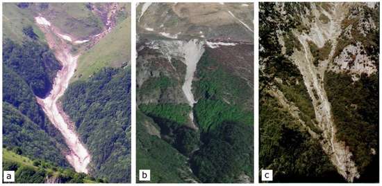
Figure 5.
Examples of different shapes of debris flow channels. (a) Acquasanta stream (Bolognola); (b) Valle dell’Acero (Ussita); (c) Infernaccio (Montefortino).
The investigated phenomena generally start along slopes with an angle greater than 30° and they flow along channels whose inclinations range from 13° to 45° (mostly from 15° to 25°), while accumulation areas have slopes that are less steep (from 2° to 7°). In particular, areas with slopes exceeding 30° correspond to an outcropping or sub-surfacing rock area in the basin, while areas with lower slope angles correspond to situations where debris flows have accumulated at the bases of slopes, constituting materials that can be easily mobilized. High slope angles, as well as the absence of vegetation and low permeability, facilitate abundant surface outflows in response to intense rainstorms, most frequent during spring and autumn. These features, together with heavy rain events, determine a very limited use of correction of the closing section to reduce the possibility of conveying large masses of water in a short time, thus resulting in debris flows where enough loose and saturated debris is present.
The basins studied were found to be generally characterized by elongated shapes (length-to-width ratio greater than 10:1-to-50:1), in analogy with what has been found in alpine and central and northwest European areas [33,34,35,36,37,38,39,40,41,42,43,44] and, less frequently, in other portions of the Apennines [9,10,13,14,15,45,46].
The transported material had varying sedimentological characteristics depending on numerous factors such as incision geometry, slope and shape of the channel, distance from the source area, genesis and thickness of the removable material.
In the sedimentation/accumulation area, alluvial fans were usually deposited [12,14,15,47,48], generally consisting of medium-to-coarse, poorly reworked and sorted gravels, with faint traces of stratification. We surmised that their deposition was due to intense flow processes, as supported by gully morphologies identified in the upper parts of the slopes and by the scarcely developed hydrographic network.
Other deposits presented a peculiar lobed shape, with heterogeneous granulometry, though mainly coarse as the finer solid load was washed away. Sometimes, deposits were sorted (in the front and the banks, characterized by coarser material) while sedimentary structures or stratification was not found. Most of the sediments, before reaching this area, temporarily accumulated along the channel, from where they were transported away later to the retention basin (Figure 5).
Debris flow deposits showed neither stratification nor sorting and their granulometric characteristics varied from clays to pebbles. They generally developed from the thick soil cover, mobilizing the most superficial levels (up to 2 m thick). They were usually located along steep slopes that gradually tended to decrease in slope along the valley until giving rise to flat or U-shaped valleys (Figure 4). The shapes of these valleys, formed by fluvio-glacial and fluvio-torrential processes, assumed a regular longitudinal profile (average slope around 10–15%) while, transversely, their section was characterized by a flat surface in the central portion bordered by very steep edges on the sides of the valleys.
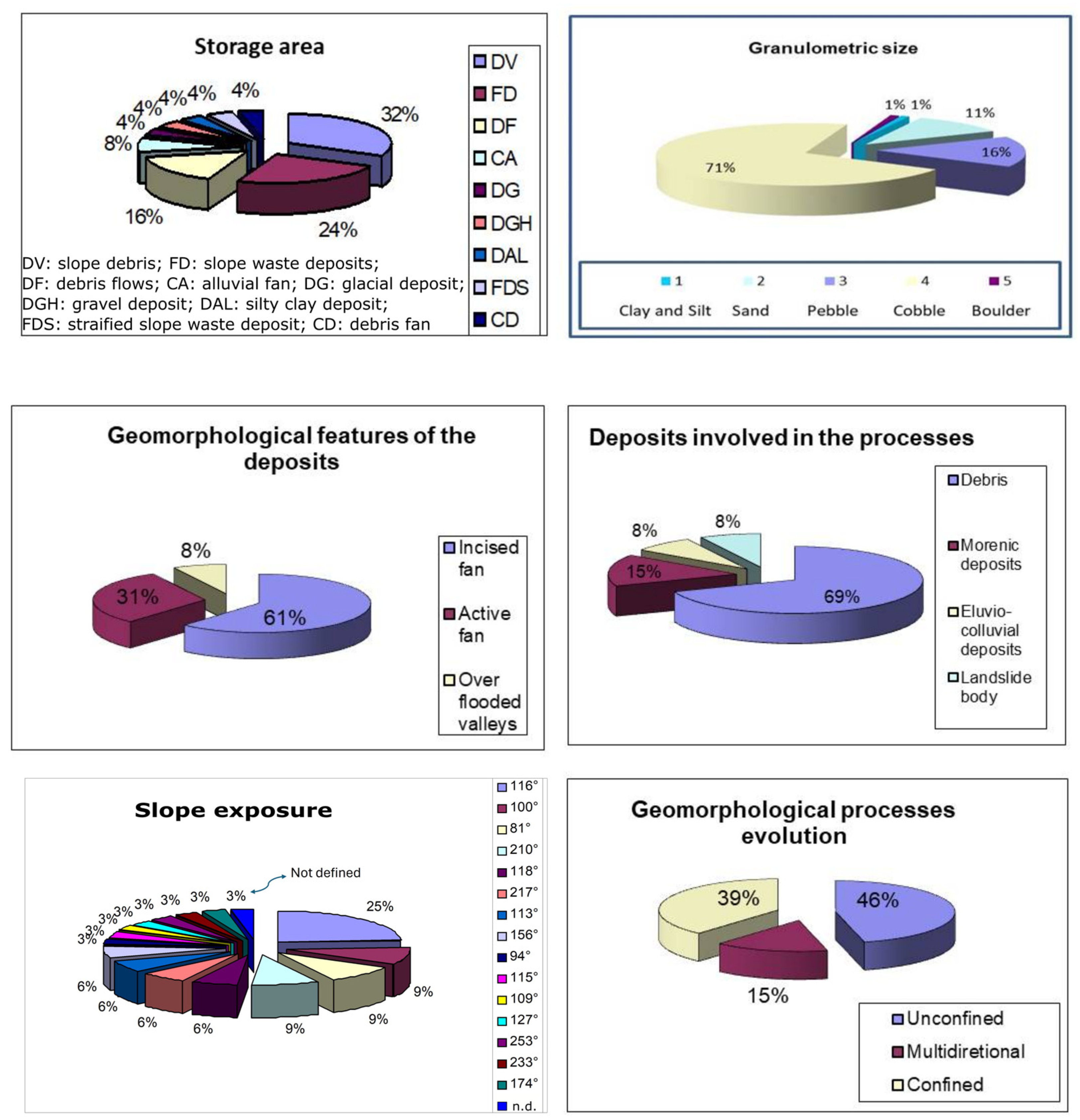
4.2. Statistical Analysis
Statistical analysis of the processes detected, both in the field and from multi-temporal aerial photos (Figure 3), enabled us to verify that about 70% of the recognized debris flows were still active (Figure 6) (using the meaning of “active” in the relevant literature [1,2,6,7]), while the remaining 30% showed no signs of recent activity and thus were considered “dormant”, manifesting as debris material at the bottom of channels with sharply beveled channel edges [12,14,25,32,33]. Debris flows originated where sediment removal prevailed over deposition, generally on slopes of 15° and 20°, sparsely vegetated and naturally characterized by the presence of abundant loose debris that could be mobilized by a relatively sudden water input.

Figure 6.
Geomorphological features of investigated debris flows and their statistical analysis.
The investigation also showed that debris flow occurrence was strongly conditioned by predisposing factors such as the slope of the source area (generally greater than 35–40%), the geo-mechanical characteristics of the rock mass (especially the stratification and fracturing of the substrate) due to the tectonic evolution of the area (evidenced especially by recent seismic activity) or due to frost weathering processes [49,50,51], the abundance of removable and poorly cemented debris material and the saturation of loose material in situ.
The trigger zone of these processes was distributed among a range of slopes of above 20° angles, while the propagation zone was distributed among a range of slopes of between 3° and 40° angles, with a concentration of transport events on slopes of between 5° and 20° angles. Finally, the stopping and deposition zones were concentrated on slopes of angles varying between 2° and 7°, in agreement with research carried out in other areas of the world [3,31,33,39,40,41].
Morphometrically, the debris flows generally showed a much greater length than their width; this ratio was between 10:1 and 50:1. In the upper parts of the slopes, the mobilized material tended to increase in volume due to erosion and abrasion of the materials on the bottom and sides of the channels, producing a self-feeding phenomenon similar to that of avalanches.
4.3. Chronology of the Processes
The Sibillini Mt. Range and, in particular, the upper Nera River Valley (Figure 1) have always been characterized by flood events accompanied by debris flows and debris avalanches, as reported in both oral testimonies and archive sources [9,10,12,14,45,46,52,53,54].
With the aim of highlighting the time succession of such events, starting from the above historical information, accurate geomorphological and sedimentological surveys were carried out, and we also performed a detailed multitemporal analysis of aerial photographs, both for the morphological evidence of the channels along which the debris flowed and of the deposits found there and at the bases of slopes [17,45,46].
This complex study allowed us to infer that, during the last five centuries, at least six catastrophic events occurred in different parts of the upper Nera R. Valley (Calcara, Vallazza, Vallinfante, Macchie and Renari di Capriglia).
By correlating Quaternary morphologies and sediments (such as terraced alluvial deposits and glacial, nivo-glacial and fluvio-glacial deposits) individuated in the study area, it was possible to date the debris flow deposits to the end of the Upper Pleistocene–Lower Holocene [17,49]. In particular, the debris fans located along the northwestern slope of Mt. Vettore (Figure 2) were attributed to phenomena active during the Upper Pleistocene, successively incised by more recent (early Holocene) debris flows (Figure 7).
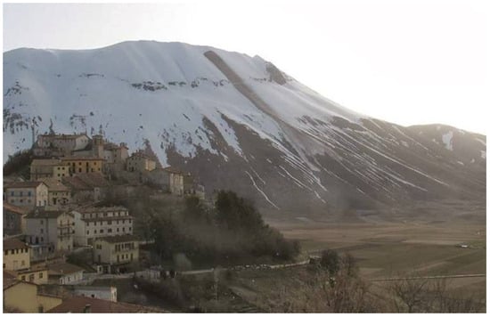
Figure 7.
Mt. Vettore: in the foreground, recent debris flow phenomena involving debris deposits attributed to the Upper Pleistocene, displaced due to reactivation along a snow avalanche channel.
The deposit located at Foce, featuring a flat-bottomed valley with an average dip of around 13%, could be ascribed to the same typology of phenomena. This valley has a smooth U-shaped transversal profile, and it is about 200 m wide and 3 km long. It originates from the glacial valley located at the head of the Aso River, where Würm moraines are present [12,49,50,51].
At Castro, in the upper portion along the Tenna R. Valley, we individuated an old debris flow deposit [15], deeply cut by fluvial erosion. In its upper portion, the deposit shows features typical of a mixed origin (i.e., debris flows and fluvial processes), while downstream, it becomes purely fluvial. The shape of the valley, whose slopes show terraced surfaces of the third order of fluvial terraces, allows us to hypothesize that the above deposit, created by debris flows taking up moraine deposits from the glaciers whose cirques are well-evident in the top part of the valley [11,12,31], can be to be attributed to the final Upper Pleistocene.
When referring to historical studies, as previously mentioned, it is possible to attribute many of the debris flows present in the Sibillini Mt. Range to the Middle Ages or later, mostly to the so-called Little Ice Age [18].
The main destructive events took place in a period ranging from the 15th to the 19th centuries (1394, 1406, 1494, beginning of the 17th century, 1667, 1670, 1807, 1858 and 1906) [52,53,54]. The same documentary sources for events starting from the mid-15th century, supporting the above deduction, often underline the need to carry out hydraulic remediation works [9,12] after such events.
By comparing the morphologies of ancient and recent processes [9,10,12,14], it is possible to carry out at least a qualitative chronological assessment and classification. In this case, older phenomena show borders slightly rounded with a thin colluvial deposit, local partial incision of deposits by running water [39,40,41,43], well-developed vegetation cover and, often, remnants of old artifacts dating back from the Middle Ages [12,17]. The activation of these older phenomena can be related to the Upper Pleistocene–Lower Holocene deglaciation, when abundant flows of fusion water along slopes induced the activation of many gravitational phenomena.
As for Medieval processes, intense agricultural interventions and deforestation are the most probable predisposing factors, since anthropic interventions increased the production of widespread debris, creating the necessary conditions for the activation of debris flows. These included agricultural practices even in high mountainous areas, which favored the formation of debris material that was easily removed as a result of rainfall and snowfall [18,52,53,54].
In the period between the late Middle Ages and the mid-19th century, what is usually referred to as the Little Ice Age [18], the activation of debris flows and other mass movements was attributable to worsening climatic conditions and the consequent increase in precipitation. Cold temperatures with frequent and abundant snowfalls, even though not comparable with the Pleistocene ones, may have caused an increase in the piezometric level, thus destabilizing the debris located along slopes and valleys, as well as led to the abandonment of agricultural practices in much of the area.
From the 19th century to the middle of the 20th century, agricultural practices were carried out again in the previously abandoned sites, and now with more intensity due to technological innovations, inducing slope instability. In the study area, mitigation works were non-existent or poor. Accordingly, debris flow events occurred. In 1959, the town of Visso was completely submerged and the deposits left by the inundation were so thick that it took more than one year to remove them [54].
Elsewhere, mitigation works, where present, efficiently contributed to reducing the activation of debris flows, as did technological improvements introduced during the last two decades of the study period.
In recent times, new approaches to managing the rural landscape may be considered the main cause of the controlled debris flows recently activated.
5. Discussion
In many areas of the Apennine Ridge and, in particular, in the Sibillini Mountain Range, there have long been reported processes of hydrogeological instability involving more or less anthropized areas [11,12,16,19,25,45,46]. Of these, debris flow processes represent the most frequent type and, due to their extremely rapid nature, also the most dangerous. The historical record [9,10,14,52,53,54] shows that such phenomena have a sometimes-annual recurrence and are mainly related to liquid or solid meteoric precipitation.
During the recent seismic crisis in the central Apennines that occurred from 2016, although no newly activated rapid flow processes were found, small local reactivations occurred, mainly related to precipitation following the January 2017 earthquakes [55].
The presence of snow within avalanche gullies and the presence of coarse, chaotic debris material have been interpreted as signals of potential forthcoming avalanche processes. This is because melting snow, saturating the debris body, triggers run-off process by following the channel previously formed by a snow avalanche.
Similarly, a slope with poor vegetation, either because of deforestation processes due to human action or due to fire, favors the activation of debris flows. Reports of such events were found in the areas of Visso, Ussita and Castelsantangelo sul Nera (Figure 1) [12], although recently, as a result of interventions through fire lines on Apennine forest slopes, it has been possible to reduce the incidence of such phenomena.
Despite limitations in the study of hydrodynamic conditions such as analysis of sediment transport and evaluation of triggering thresholds of debris flow, the present work represents a first step in the analysis of these phenomena, which although frequent, typical of this area of the Umbria–Marche Apennines and potentially very dangerous, so far, have never been exhaustively studied. The assumptions and results of the present study, therefore, provide useful elements to support the planning and implementation of adequate mitigation and territorial safeguarding interventions, especially in areas not yet anthropized and characterized by a high level of debris flow hazard.
The methods, results and philosophy of this research, as explained in Figure 3, were intended to be shared with the public in an open workshop, mostly aimed at local communities. In this workshop, we planned to explain the territorial resources and fragilities, and we wished to share testimonials from the mediatic world, and some geo-tourism proposals, as well, to make the proposed topics more appealing and the suggested risk-prevention initiatives more impressive [47,55]. Unfortunately, the COVID-19 emergency made the event impossible. Furthermore, when the pandemic hit the headlines, it moved these themes to the background of people’s priorities.
Events that have recently affected the entire society in recent decades have highlighted the difficulty of bringing in new ways of thinking and new behaviors, which, in this case, requires promoting greater knowledge of natural hazards and the perception of risk associated with them, both of which are necessary to spur on efforts to prevent them [55].
A potential way to increase awareness of the possible consequences of extreme hydrogeological events for the territory and society is to raise awareness of the natural history of the territory and the mechanisms that have determined its evolution.
Furthermore, information sharing and initiatives to raise understanding among the public of natural events are certainly obligatory steps that may take on strong social growth after certain initial progress is made. In these regards, it is becoming easier to read the natural landscape and note its continuous transformations thanks, in particular, to the use of GIS computerized mapping. Tools such as GIS, which are fundamental to the collection and processing of a large amount of data, are currently seeing great development in knowledge and prevention. However, despite the availability of GIS tools for some years, their dissemination does not yet seem to have been particularly effective in inducing greater social consciousness, nor has it helped with inspiring virtuous behavior at an extended social level.
The publicly held geographic information system (PPGIS) [56,57] was conceived as a means for GIS technology to support public participation, especially among local or marginalized populations, in planning and decision processes [58]. The PPGIS can be considered a natural evolution of GIS as a tool in participatory democracy, supporting a community-based approach to participating in public affairs. The concept of a community-based approach was originally aimed at giving people targeted for humanitarian assistance “the right to participate in making decisions that affect their lives” as well as “a right to information and transparency” from those responsible for assisting them [59,60,61,62,63,64,65,66]. This idea becomes particularly important in the context of processes where unpredictability and recurrence mean that the hazard and risk are high [67,68,69].
Additionally, we can consider the scenario from a wider perspective, and look to how debris flows occur not only in Italy. When neighboring countries are part of the picture, it is relevant to note that European institutions wish to bring citizens closer together and enable them to be active protagonists in the EU policy system, as well as make participatory tools more user-friendly [69].
Lastly, the right of participation for all takes on vast significance when we consider the relationship between humanity and Earth, alluding to the broader concept of participatory democracy impacting the fate or our planet.
6. Conclusions
The assessment of the hydrogeological hazard associated with debris flows requires identification and quantitative evaluation of the factors linked to the triggering, propagation and deposition of the material involved. These issues are not easy to explore, however, due to the very definition of a “debris flow”, which can include a large spectrum of slope instability phenomena, which are significantly variable in terms of mechanical properties of the materials, geomorphological characteristics of the processes and hydrological and permeability conditions of the soil.
In general, however, their high destructive power—linked to the near-impossibility of predicting them at present—has led to growing interest, in recent years, in the risk of debris flows. In previous years, the risk-management approach used has not always been able to satisfy the needs of a society whose development proceeds rapidly, effectively preventing the achievement of an adequate level of knowledge in society of the phenomena. Technical issues have long been central to the theme of rapid events, while technical developments have led to a reduction in relative hazard and risk. However, the collective opinion of many of those working on natural hazard mitigation, especially in developing countries, is that socio-cultural issues are at least as important as technical choices when we consider how best to improve the effectiveness of the interventions themselves.
Because of the difficulty in predicting and controlling debris flows, it is beneficial for mitigation systems to employ multiple elements in order to increase their chances of success. These must include the education of local people; knowledge and awareness of the hazard and poor predictability of events; adequate warning modes; interim interventions such as channelization and debris interception; and remedial interventions such as weirs or structural interventions. Furthermore, in upland areas that are now uncultivated or abandoned, the restoration of slope maintenance activities can be added to the mitigation methods to reduce water flow and sediment transport.
Author Contributions
Conceptualization, P.F.; methodology, P.F.; data curation, P.F.; writing—original draft preparation, P.F.; writing—review and editing, F.B. All authors have read and agreed to the published version of the manuscript.
Funding
This research received no external funding.
Institutional Review Board Statement
Not applicable.
Informed Consent Statement
Not applicable.
Data Availability Statement
The dataset is available on request from the authors.
Acknowledgments
The authors would like to thank Carlo Bisci of the Geology Section of the University of Camerino for his insights and constant support during the writing phase and Raul Menichelli for English revisions.
Conflicts of Interest
The authors declare no conflicts of interest.
References
- Costa, J.E. Physical geomorphology of debris flows. In Developments and Applications on Geomorphology; Costa, J.E., Fleisher, P.J., Eds.; Springer: Berlin, Germany, 1984; pp. 268–317. [Google Scholar]
- Johnson, A.; Rodine, J.R. Debris flows. In Slope Instability; Wiley & Sons: Hoboken, NJ, USA, 1984; pp. 257–361. [Google Scholar]
- Takahashi, T. Debris flows. In IAHR Monograph; Balkema: Rotterdam, The Netherlands, 1991; 165p. [Google Scholar]
- Innes, J.L. Debris flows. Progr. Phys. Geogr. 1983, 7, 469–501. [Google Scholar] [CrossRef]
- Seminara, G.; Tubino, M. Debris Flows: Meccanica, Controllo e Previsione; Presidenza del Consiglio dei ministri, Dipartimento della Protezione Civile: Roma, Italy, 1993. [Google Scholar]
- Coussot, P.; Meunier, M. Recognition, classification and mechanical description of debris flows. Earth Sci. Rev. 1996, 40, 209–227. [Google Scholar] [CrossRef]
- Cheng, L.C. Debris Flow Hazards Mitigation: Mechanics, Prediction and Assessment; ASCE: Reston, VA, USA, 1997; 394p. [Google Scholar]
- Iverson, R.M. The physics of debris flows. Rev. Geophys. 1997, 35, 245–296. [Google Scholar] [CrossRef]
- Buccolini, M.; Gentili, B.; Marchetti, P.; Pambianchi, G. II sovralluvionamento olocenico nell’alto bacino del fiume Nera (Marche). Mem. Della Soc. Geol. Ital. 1989, 42, 343–349. [Google Scholar]
- Guzzetti, F.; Cardinali, M. Debris flows phenomena in the Central Apennines of Italy. Terra Nova 1991, 3, 619–627. [Google Scholar] [CrossRef]
- Dramis, F.; Gentili, B.; Pambianchi, G.; Aringoli, D. La morfogenesi gravitativa nel versante adriatico marchigiano. Studi Geol. Camerti Nuova Ser. 2002, 1, 103–125. [Google Scholar]
- Gentili, B. Note di Geomorfologia del Parco Nazionale dei Monti Sibillini. In Quaderni Scientifico-Divulgativi, Parco Naz. dei Monti Sibillini; n° 6; Aniballi: Ancona, Italy, 2002; 50p. [Google Scholar]
- Conversini, P.; Salciarini, D.; Felicioni, G.; Boscherini, A. The debris flow hazard in the Lagarelle Creek in the eastern Umbria region, central Italy. NHESS 2005, 5, 275–283. [Google Scholar] [CrossRef]
- Farabollini, P.; Spurio, E. Applicazione dei GIS nello studio dei fenomeni di debris flows dell’appennino umbro-marchigiano (regione Marche, Italia). Rend. SGI Online 2008, 8, 50–58. [Google Scholar]
- Farabollini, P.; De Pari, P.; Discenza, M.E.; Minnillo, M.; Carabella, C.; Paglia, G.; Miccadei, E. Geomorphological evidence of debris flows and landslides in the Pescara del Tronto area (Sibillini Mts, Marche Region, Central Italy). J. Maps 2020, 17, 90–99. [Google Scholar] [CrossRef]
- Aringoli, D.; Farabollini, P.; Pambianchi, G.; Materazzi, M.; Bufalini, M.; Fuffa, E.; Gentilucci, M.; Scalella, G. Geomorphological Hazard in Active Tectonics Area: Study Cases from Sibillini Mountains Thrust System (Central Apennines). Land 2021, 10, 510. [Google Scholar] [CrossRef]
- Materazzi, M.; Gentili, B.; Aringoli, D.; Farabollini, P.; Pambianchi, G. Elements of slope and fluvial dynamics as evidence of late Holocene climatic fluctuations in the central Adriatic sector, Italy. Geogr. Fis. Din. Quat. 2010, 33, 193–204. [Google Scholar]
- Pinna, M. La storia del clima: Variazioni climatiche e rapporto clima-uomo in età post-glaciale. Mem. Della Soc. Geogr. Ital. 1984, 36, 1–264. [Google Scholar]
- Centamore, E.; Deiana, G. (Eds.) La Geologia delle Marche; Special publ.; Università di Camerino, Dipartimento di Scienze della Terra: Camerino, Italy, 1986; 145p. [Google Scholar]
- Calamita, F.; Deiana, G. The arcuate shape of the Umbria-Marche Apennines (Central Italy). Tectonophysics 1988, 146, 139–147. [Google Scholar] [CrossRef]
- Lavecchia, G. II sovrasconimento dei Monti Sibillini; analisi cinematica e strutturale. Boll. Della Soc. Geol. Ital. 1985, 104, 161–194. [Google Scholar]
- Festa, A. Evoluzione strutturale del settore meridionale del sovrascorrimento dei Monti Sibillini (Appennino centrale). Mem. Soc. Geol. It. 2002, 57, 369–377. [Google Scholar]
- Calamita, F.; Esestime, P.; Paltrinieri, W.; Scisciani, V.; Tavarnelli, E. Structural inheritance of pre-and syn-orogenic normal faults on the arcuate geometry of Pliocene-Quaternary thrusts: Examples from the Central and Southern Apennine Chain. Ital. J. Geosci. 2009, 128, 381–394. [Google Scholar]
- Cello, G.; Mazzoli, S.; Tondi, E.; Turco, E. Active tectonics in the central Apennines and possible implications for seismic hazard analysis in peninsular Italy. Tectonophysics 1997, 272, 43–68. [Google Scholar] [CrossRef]
- Coltorti, M.; Farabollini, P. Quaternary evolution of the “Castelluccio di Norcia” basin (Umbro-Marchean Apennines, central Italy). II Quat. J. Quat. Sci. 1995, 8, 149–166. [Google Scholar]
- Bisci, C.; Fazzini, M. Climatic features of the central southern marches (Central Italy). In Proceedings of the “Natural Hazard on Built-Up Areas”; CERG, 2000; pp. 45–47. [Google Scholar]
- Bisci, C.; Fazzini, M.; Rapetti, F. Gli afflussi idrometeorici. In Atlante Tematico delle Acque d’Italia; Brigati: Genova, Italy, 2008; pp. 21–28. [Google Scholar]
- Fazzini, M.; Romeo, V. L’enneigement dans les Apennins durant les derniers 30 ans. In Proceedings of the Actes XXIV Colloque AIC “Climat Montagnard et Risques”; Stamperia Romana: Roma, Italy, 2011; pp. 249–254. [Google Scholar]
- Pisano, A.; Marullo, S.; Artale, V.; Falcini, F.; Yang, C.; Leonelli, F.E.; Santoleri, R.; Buongiorno Nardelli, B. New Evidence of Mediterranean Climate Change and Variability from Sea Surface Temperature Observations. Remote Sens. 2020, 12, 132. [Google Scholar] [CrossRef]
- Nevini, R. Carta di Localizzazione Probabile delle Valanghe dei Monti Sibillini; Regione Marche-Protezione Civile: Ancona, Italy, 1998. [Google Scholar]
- Takahashi, T. Evaluation of the factors relevant to the initiation of debris flow. New Delhi India 1980, 3, 136140. [Google Scholar]
- Crosta, G.; Guzzetti, F.; Marchetti, M.; Reichenbach, P. Morphological classification of debris flow processes in South-Central Alps (Italy). In Proceedings of the 6th International IAEG Congress, Amsterdam, The Netherlands, 6–10 August 1990; pp. 1565–1572. [Google Scholar]
- Nieuweinhuijzen, M.E.; van Steijn, H. Alpine debris flows and their sedimentary properties. A case study from French Alps. Permafr. Periglac. Process. 1990, 1, 111–128. [Google Scholar] [CrossRef]
- Rikenmann, D.; Zimmerman, M. The 1987 debris flows in Switzerland: Documentation and analysis. Geomorphology 1993, 8, 175–189. [Google Scholar] [CrossRef]
- Govi, M.; Marchi, L.; Mortara, G.; Turitto, O. Ricerche Sulle Colate Detritiche Torrentizie (Debris Flow) in Ambiente Alpino; Rapporto 1990/91; CNR-GNDCI: Roma, Italy, 1992; pp. 405, 420. [Google Scholar]
- Marchi, L.; Tecca Pia, R.; Liu, X. Recent developments in debris flow research in Italy. Chin. Geogr. Sci. 1995, 5, 275–287. [Google Scholar] [CrossRef]
- Deangeli, C.; Giani, G.P. Studi sperimentali sulle colate di detrito. In La Prevenzione delle Catastrofi Idrogeologiche: Il Contributo della Ricerca Scientifica; Consiglio Nazionale delle ricerche: Roma, Italy, 1996; Vol. 2, pp. 169–174. [Google Scholar]
- Van Steijn, H. Debris-flow magnitude-frequency relationship for mountainous regions of Central and Northwest Europe. Geomorphology 1996, 15, 259–273. [Google Scholar] [CrossRef]
- Tropeano, D.; Turconi, L. Colate detritiche del 12, 15 e 16 agosto 1998 in alta valle di Susa (Piemonte). GEAM 94 1998, 35, 177–188. [Google Scholar]
- Tropeano, D.; Turconi, L. Sediment budget for a high-mountain catchment in the western Italian Alps. GEAM 95 1998, 293–302. [Google Scholar]
- Berti, M.; Genevois, R.; Simoni, A.; Tecca, P.R. Field observations of a debris flow event in the Dolomites. Geomorphology 1999, 29, 265–274. [Google Scholar] [CrossRef]
- Tropeano, D.; Turconi, L. Valutazione del Potenziale Detritico in Piccoli Bacini delle Alpi Orientali, Pubbl. n. 2058. 1999; 151p.
- Deganutti, A.M.; Pasuto, A.; Silvano, S.; Tecca, P.R. Colate detritiche in ambiente alpino. In Proceedings of the Previsione e Prevenzione di Movimenti Franosi Rapidi, Trento, Italy, 1–19 June 1999; pp. 123–131. [Google Scholar]
- Fioraso, G. Indagini geologico-morfologiche su aste torrentizie della Valtellina e della Valle di Susa ricorrentemente soggette a colate detritiche torrentizie (debris flow). Quad. Studi Doc. Suppl. GEAM 2000, 37, 1–59. [Google Scholar]
- Cardinali, M.; Guzzetti, F.; Reichenbach, P. Progetto AVI—Relazione di sintesi. In Consiglio Nazionale delle Ricerche—Gruppo Nazionale per la Difesa dalle Catastrofi Idrogeologiche; 1993; 39p. [Google Scholar]
- Cipolla, F.; Lolli, O.; Pagliacci, S.; Russo, D.; Sebastiani, C. Rapporto di sintesi [20 regioni italiane]. CNR-GNDCI, Progetto AVI, Pubblicazioni n. 1441–1448 e 1452–1462, 1994–1995. 1995. [Google Scholar]
- Kellerhals, R.; Church, M. Hazard management on fans, with examples from British Columbia. In Alluvial Fan: A Field Approach; Rachocki, C., Ed.; Wiley & Sons: Hoboken, NJ, USA, 1990; pp. 335–354. [Google Scholar]
- Whipple, K.; Dunne, T. The influence of debris flow rheology on fan morphology, Owen valley, California. Geol. Soc. Bull. 1992, 104, 887–900. [Google Scholar] [CrossRef]
- Dramis, F.; Coltorti, M.; Gentili, B. Glacial and periglacial morphogenesis in the Umbria-Marche Apennines. In Proceedings of the 24th International Geographical Congress, Tokyo, Japan, 1–5 September 1980; pp. 114–115. [Google Scholar]
- Jaurand, E. Les héritages glaciares de l’Apennin. In Thèse de Doctorat, Université Paris 1—PanthéonSorbonne; 2 tomes; 1994; 601p. [Google Scholar]
- Coltorti, M.; Dramis, F. Geologia e Geomorfologia dei M. Sibillini; Tecnoprint: Ancona, Italy, 1990. [Google Scholar]
- Chienti e Potenza. Anno XX, n.31 del 05.08. 1906.
- Pirri, D.P. Ussita. In Notizie Storiche; Tip. Poliglotta Vaticana: Roma, Italy, 1920. [Google Scholar]
- Fabbi, A. Visso e le Sue Valli; Ed. Panetti e Petrillo: Spoleto, Italy, 1977. [Google Scholar]
- Di Bucci, D.; Casarotti, C.; Morsut, C.; Polese, M.; Rebora, N.; Giuliani, F.; Rodrigues, T.; Viegas, D.X.; Fagà, G.; Centoducati, C.; et al. Shared basic elements for a ‘European Doctrine on Disaster Risk and Crisis Management’—The RODMAP Vision Paper. ROADMAP Proj. 2022, 1–32. [Google Scholar] [CrossRef]
- Brown, G. Public Participation GIS (PPGIS) for regional and environmental planning: Reflections on a decade of empirical research. URISA J. 2012, 25, 5–16. [Google Scholar]
- Lugeri, F.R.; Farabollini PLugeri, F.; Farabollini, P.; De Pascale, F.; Lugeri, N. PPGIS applied to environmental communication and hazards for a community-based approach: A dualism in the Southern Italy “calanchi” landscape. AIMS Geosci. 2021, 7, 490–506. [Google Scholar] [CrossRef]
- Mori, T.; Tanaka, H.; Kurihara, J.; Mori, K.; Tsuzuki, N. Dissemination of Information on Debris Flow Hazard Areas Using GIS Technology; Sabo Frontier Foundation: Tokyo, Japan, 2008. [Google Scholar]
- Maskrey, A. Disaster Mitigation: A Community-Based Approach; Oxfam: Oxford, UK, 1989. [Google Scholar]
- Bankoff, G.; Frerks, G.; Hilhorst, T.; Hilhorst, D. (Eds.) Mapping Vulnerability: Disasters, Development, and People; Routledge: London, UK, 2004. [Google Scholar]
- Batista, F.; Baas, S. The Role of Local Institutions in Reducing Vulnerability to Recurrent Natural Disasters and in Sustainable Livelihoods Development: Consolidated Report; FAO Rural Institutions and Participation Service: Rome, Italy, 2004. [Google Scholar]
- Santi, P.M.; Higgins, J.D.; Cannon, S.H.; DeGraff, J.V. Evaluation of Post-Wildfire Debris Flow Mitigation Methods and Development of Decision-Support Tools. Joint Fire Science Program, JFSP Contract 03-1-4-14, 2006, 50p. Available online: http://www.firescience.gov/ (accessed on 13 November 2009).
- Hewitt, K. Preventable disasters: Addressing social vulnerability, institutional risk and civil ethics. Geogr. Rundsch. 2008, 3, 43–52. [Google Scholar]
- Miceli, R.; Sotgiu, I.; Settanni, M. Disaster preparedness and perception of flood risk: A study in an alpine valley in Italy. J. Environ. Psychol. 2008, 28, 164–173. [Google Scholar] [CrossRef]
- Keim, M.E. Building human resilience the role of public health preparedness and response as an adaptation to climate change. Am. J. Prev. Med. 2008, 35, 508–516. [Google Scholar] [CrossRef] [PubMed]
- Hewitt, K. Culture and risk: Understanding the sociocultural settings that influence risk from natural hazards: Synthesis report from a global e-conference. In ICIMOD and the Mountain Forum; International Centre for Integrated Mountain Development (ICIMOD): Kathmandu, Nepal, 2009. [Google Scholar]
- Santi, P.M.; Hewitt, K.; VanDine, D.F. (Eds.) Debris-flow impact, vulnerability, and response. Nat. Hazards 2012, 56, 371–402. [Google Scholar] [CrossRef]
- Huang, J.; Li, X.; Zhang, L.; Li, Y.; Wang, P. Risk perception and management of debris flow hazards in the upper salween valley region: Implications for disaster risk reduction in marginalized mountain communities. Int. J. Disaster Risk Reduct. 2020, 51, 101856. [Google Scholar] [CrossRef]
- European Citizen’s Initiative Forum. Available online: https://europa.eu/citizens-initiative-forum/blog/partecipatory-democracy-citizen-based-europe-challenges-and-perspectives_en (accessed on 20 September 2023).


Disclaimer/Publisher’s Note: The statements, opinions and data contained in all publications are solely those of the individual author(s) and contributor(s) and not of MDPI and/or the editor(s). MDPI and/or the editor(s) disclaim responsibility for any injury to people or property resulting from any ideas, methods, instructions or products referred to in the content. |
© 2024 by the authors. Licensee MDPI, Basel, Switzerland. This article is an open access article distributed under the terms and conditions of the Creative Commons Attribution (CC BY) license (https://creativecommons.org/licenses/by/4.0/).