1. Introduction
Commercial pedestrian streets, as a street form of frequent contact with city residents, pedestrians, and tourists in the walking process, are the spaces with the highest degree of crowd gathering. Good street spatial visual quality significantly influences visits by local residents, pedestrians, and tourists. Street visual quality is considered in the evaluation of street spatial quality, according to the Landscape Visual Environment Assessment, which explores the suitability of each element of the street to the main users and the development of the street from the perspective of human vision both qualitatively and quantitively. Street businesses show a high degree of correlation with the degree of crowd concentration. In reality, different commercial streets have different development purposes, functional combinations, and degrees of completion of construction, leading to differences in visual–spatial quality between different commercial streets and between different parts of the same commercial street. In the face of the actual needs of the development of commercial pedestrian streets, the quantitative evaluation of the visual quality of street space can systematically assess the strengths and weaknesses of street space as a whole, which can help to clarify the direction of the sustainable optimization of the visual quality of street space and the efficiency of the optimization work [
1], and also play an important role in optimizing the distribution of the functions of the commercial pedestrian street and enhancing the experience of tourists. As consumer needs and expectations increasingly favor social and experiential shopping street functions, the need for a sustainable evaluation of the visual–spatial quality of streets is becoming more and more important [
2]. This study proposes a method and index system applicable to the evaluation of the visual–spatial quality of commercial pedestrian streets from an objective perspective and conducts an empirical study on the example of the commercial pedestrian street on Binjiang Road in Tianjin. The findings will inform the further exploration of the impact of commercial pedestrian street visual–spatial quality on pedestrian behavioral decision making and aggregation and will be used to guide the generation of optimized strategies for commercial pedestrian street spatial design, management, and sustainable regeneration.
At present, domestic and international research on the spatial quality of urban commercial pedestrian streets mainly focuses on the assessment of characteristics and the innovation of research perspectives and methods on this basis. As commercial pedestrian streets are block types with generally long pedestrian dwell times, both macro and micro perspectives have been used in the assessment of characteristics. On the one hand, the overall environmental characteristics and walking mechanisms [
3] of walking behavior in commercial pedestrian streets are studied at the macro level, such as walking safety [
4,
5,
6], accessibility [
7], density of the blocks [
5], density of functions [
8], and degree of connectivity of the pedestrian system [
9]. On the other hand, attention is paid to the experience of walking at the micro level, such as walking evaluation [
10], related recreational walking, the green vision level [
11], the street environment [
12], the business negativity index [
13], and color coordination [
14]. The research perspectives are divided into subjective and objective perspectives. The subjective research perspective is mainly through the interaction with pedestrians to obtain the evaluation of the spatial perception of the commercial pedestrian street, usually using the interview method [
15,
16], questionnaire surveys [
17], empirical evaluations [
18], etc. The objective research perspective involves comprehensively evaluating the quality of the space itself by quantitatively extracting different features of the space itself, which is usually carried out using data sources such as street-view images, photographic images [
19], wearable sensors [
20], and web-based open-source APIs [
21,
22], and by using research techniques such as machine learning [
23] and statistical modeling [
24,
25].
In the construction of a street space quality evaluation system, street space is a part of the urban built environment; in recent years, many scholars, regarding streets, combined urban design quality models with different quantitative index systems for quality measurement, from the density, diversity, and design as the core of the 3D concept, extended to supplement the “Destination Accessibility and Distance to Transit” of the 5D concept [
26]. Many studies have constructed indicator systems for evaluation and measurement based on this concept. For example, Ye Yu et al. [
27] constructed a streetscape evaluation index from the index system framework by using six dimensions, including the “green vision index, sky visibility index, building interface, motorization rate, walkability, and diversity”. Chen, L. et al., using the 5D framework including density, diversity, design, destination accessibility, and distance to transit, explored the associations with pedestrian volume [
28]. More scholars have quantitatively evaluated the street environment through the remaining characteristics of the street, such as visual entropy [
29], pedestrian presence percentage [
30], walkable area size [
31], and other index systems on this basis. The indicator evaluation systems of related studies are summarized in
Table 1.
To sum up, the works of the scholars listed above were from the street objective perspective. As for the research data, they have mostly chosen the street-view images provided by Baidu Map, Google Map, and Tencent Map as data to support their studies of street spatial visual quality. Usually, the street-view images are taken by vehicle-mounted cameras, which better cover the overall urban street space and comprehensively reflect the characteristics of the urban street space environment [
34]. However, there are differences between what the vehicle-mounted camera is shooting and what the pedestrians are seeing. Furthermore, due to the collection of street view data in different cities to collect the season, time, and frequency, there is a big difference, and due to the scenic spots and commercial pedestrian streets for the motor vehicle restrictions on access, the vehicle-mounted camera cannot carry out the corresponding street-view image data collection. So, this type of data source has some limitations when it comes to spatial quality assessment studies for specific streets. Therefore, in this type of research, the object can be used to simulate the visual perception of pedestrians through the experimental simulation in a way closer to the pedestrian’s perspective of the street scene image data acquisition [
35]. On this basis, it is necessary to quantify the street features in the captured street-view images using image semantic segmentation techniques for subsequent research. Currently, commonly used semantic segmentation techniques include FCN, U-Net, SegNet, Deeplab, and PSPNet. Among them, the Deeplab V3+ model is able to process input images with different scale sizes and performs well in terms of computational time and computational memory, which provides technical support for large-volume, high-precision, and high-efficiency recognition and extraction of street scene images.
Overall, there has been a considerable accumulation of research results from a subjective research perspective. Based on the extensive use of big data, the focus of current research has gradually shifted to quantitative research on the visual–spatial quality of streets from an objective perspective. Determining the perception of street users by combining visual indicators of multiple street components is gradually becoming the dominant research paradigm [
36,
37]. Therefore, this study proposes a method and index system applicable to the evaluation of the visual–spatial quality of commercial pedestrian streets from an objective perspective and conducts an empirical study with the commercial pedestrian street on Binjiang Road in Tianjin. The conclusions will provide more information about the impact of commercial pedestrian street spatial visual quality and business formats on pedestrian behavioral decisions and aggregation and will be used to guide the generation of optimization strategies for commercial pedestrian street spatial design, management, and sustainable regeneration.
3. Results and Analyses
3.1. Analysis of Visual Elements of Street Space
Based on the above metrics, the visual element data are aggregated to each intersection sampling point, and the results of visual element extraction and calculation are visualized.
As shown in
Figure 7, the visual elements in the overall spatial distribution of the commercial pedestrian street on Riverside Road present different characteristics and differences, especially in the east–west direction along the main street and the north–south direction along the main street contrast is more significant. (1) Road elements: The overall percentages of road elements along the east–west direction of Heping Road and the north–south direction of Binjiang Road are both higher, but the percentage of road elements along Heping Road is higher than that along Binjiang Road, and the main street shows the characteristic of “high east–west and low north–south” directions. The main street is characterized as “high in the east–west direction and low in the north–south direction”. This reflects the phenomenon that there is more walkable space along Heping Road than along Binjiang Road, but less amenities and greenery along the road. (2) Facility elements: in terms of the distribution of facilities, Binjiang Road, Heping Road, and Henan Road are street areas with a higher percentage of facilities, which reflecting the fact that the Binjiang Road and Heping Road main streets are more complete in terms of facility configurations. Although the facility elements in the sampling points of the two main streets show a staggered pattern, the Binjiang Road main street has higher facility elements and a more complete facility configuration than the Heping Road main street. The main street shows the characteristic of “low east–west and high north–south”. The difference between the two main streets in terms of facility elements is the opposite of how the roadway element behaves, corroborating the previous conjecture and reflecting the lesser placement of facilities along Peace Road. (3) Greening elements: The streets along Binjiang Road and the road sections connected to it have a lower proportion of greenery; the southern part of Binjiang Road and the southern road sections intersecting with it have a higher proportion of greenery, showing the characteristic distribution of “low in the north and high in the south”. The difference between the two main streets in terms of greenery elements is also opposite to that of the road elements, and a comparison between the two also confirms that there are fewer greenery elements along Heping Road compared to those along Riverside Drive. (4) Building elements: The distribution of building elements along Heping Road and Binjiang Road is relatively concentrated, and the values of the building elements are relatively close to each other, and the distribution of the building elements in the whole area shows a smooth characteristic. (5) Pedestrian element: The most intensively distributed areas are along Binjiang Road, Shandong Road and the eastern half of Heping Road, where the distribution of pedestrians along Binjiang Road is the most concentrated and continuous, and the pedestrian element shows a high and smooth distribution, while the distribution of pedestrians in the western half of Heping Road sampling points is less. The main street shows a “high north–south direction and low east–west direction”. This is roughly the same as the distribution of the road element and the greenery element, from which it can be inferred that the facilities element and the greenery element can have a positive effect on the gathering of pedestrians. (6) Sky element: the overall sky element along Heping Road is high; the sky element along Binjiang Road is low; although some sampling points have high sky element values, the overall area is still low. The main street shows the distribution characteristics of “high east–west and low north–south” directions. This is the same as the road element and the opposite of the pedestrian element. The characteristics of the road elements are the same as those of the pedestrian elements, facilities and greenery elements. It shows that compared to the sky, the arrangement of greenery and the completion of facilities, the shopping street is more attractive for people to stop and rest.
The above results show that the Binjiang Road Pedestrian Street shows a clear “north–south-east–west” distinction between the road, facilities, greenery, pedestrians, sky, and other elements on the main street. The main street in the north– direction, Binjiang Road, has more green vegetation areas in the street space, relatively well-equipped facilities, high pedestrian density and more homogeneous distribution, poor sky view, and narrower roads. The east–west main street, Peace Road, has a street space character that is roughly opposite to it. The two main streets, on the other hand, show an overall homogeneity in terms of architectural elements, indicating that the building heights and street widths of the neighborhoods are more uniformly constrained and that the distribution of architectural elements in the two areas is roughly the same and does not show significant differentiation. It shows that although there are more long-established shopping malls, such as Persuasions, within the commercial street, there is a conscious effort to unify the planning and design in the later stages of construction, resulting in a unified control of the building heights.
3.2. Street Space Visual Quality and Business Analysis
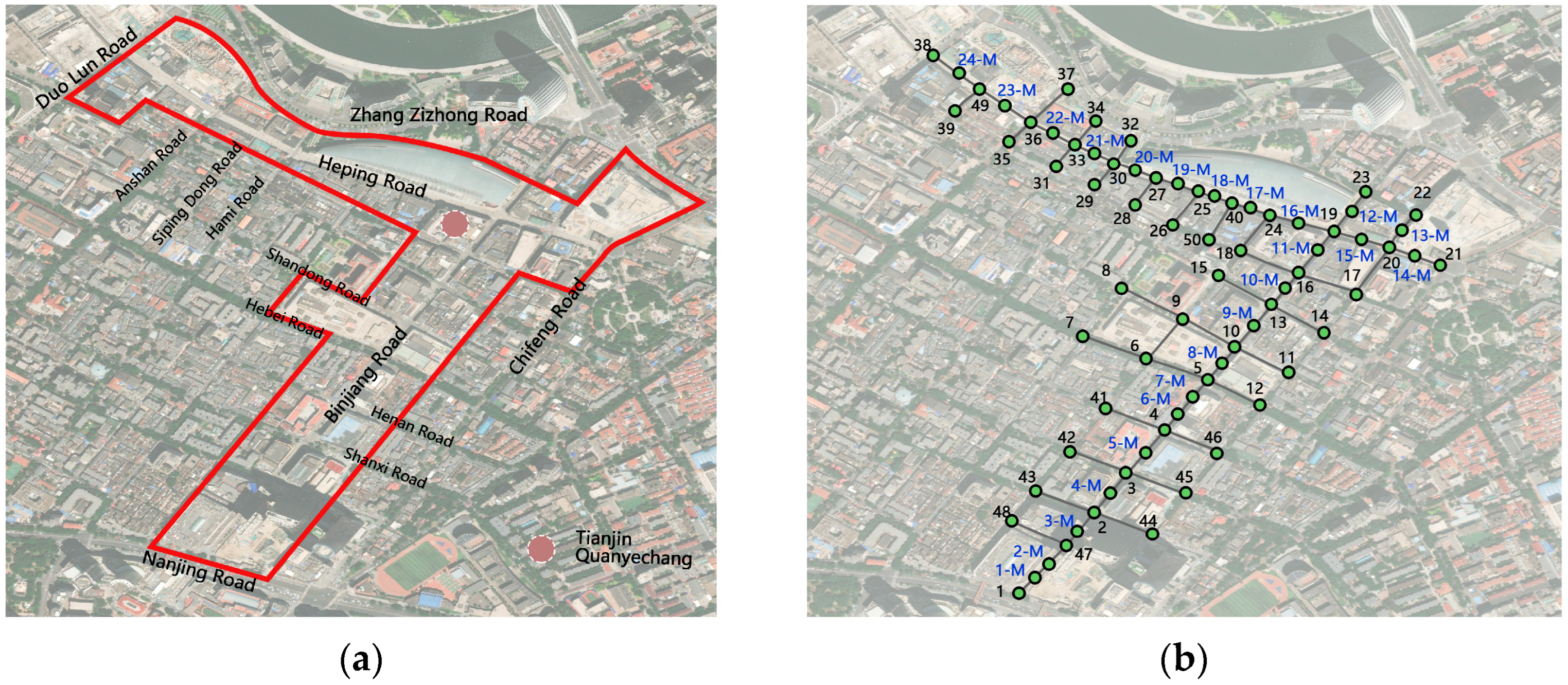
Considering that road intersections contain visual elements from all road direction views, the average value of the proportion of visual elements can only indicate the perception of the street environment at the intersection and cannot represent the situation faced and felt by pedestrians walking in the street space in the corresponding direction. The visual element information collected by pedestrians at the sampling points of road intersections is a synthesis of all the visual elements on the street space connected to the road intersections, which can provide pedestrians with the basis for their behavioral decision-making for the next direction of travel, and therefore the line features corresponding to the roads in different directions need to be further taken as the basic unit for quantitative evaluation analysis of the visual quality on the street space.
According to the geographic location of the two ends of the road line features, the street scene images collected at each sampling point of the Binjiang Road Commercial Street are matched correspondingly. The visual quality quantification results of each street are shown in the figure (
Figure 8). The quantitative results of the evaluation indicators show significant spatial differentiation, specifically: (1) The street walkability index: the overall walking index of the Binjiang Road Commercial Walking Street is relatively moderate, and only Binjiang Road along Hebei Road has the highest walking index, while the two small roads along Heping Road has the lowest walking index. It can be seen from these that Binjiang Road and Heping Road main street road width are more appropriate, showing an overall more homogeneous distribution. (2) The walking safety index: The walking safety index along Heping Road from Siping Dong Road to Chifeng Road is the highest, followed by the overall walking safety index along Binjiang Road, which is also high. However, the pedestrian safety index is generally low along most of the side streets connected to the two main streets, which is related to the reality that the main streets do not allow motorized vehicles except for ferries on the streets themselves, while the side streets are only pedestrian-vehicle segmented but still allow motorized traffic to cross the streets. It shows that as the main street of the commercial pedestrian street is the main place for people to gather and disperse, the implementation of pedestrian-vehicle segregation can play a more positive role for the personal safety of pedestrians. (3) The street enclosure index: the lowest street enclosure indices are found on Hebei Road and Anshan Road, and the enclosure indices are also lower on the east part of Hami Road, the main street of Heping Road; the overall enclosure indices of the Binjiang Road main street and the remaining main street part of Heping Road are more balanced, but the enclosure indices of the side streets along Heping Road are higher. Index are higher. This is consistent with the high road widths of the Binjiang Road and Heping Road main streets and the low road widths of their side streets. (4) The facility richness index: It can be seen that the main street of Binjiang Road and the side streets along it have the highest facility richness index, while the main street along Heping Road is on the low side, and the side streets connected to Heping Road have the lowest facility richness index. This is due to Binjiang Road itself, as Tianjin is known as a traditional commercial pedestrian street of the overall construction and maintenance of a longer period of time due to Heping Road along the east–west side of the main street is the construction of the later so worse. It also suggests that the overall amenities on main street at Riverside Drive are better laid out and more visually appealing to the crowd. (5) The street greenness index: the street greenness index is higher in the southern half of Hebei Road and Binjiang Road, but decreases the further north you go, and is lower along the east–west main street of Heping Road. This corresponds to the distribution of the facility richness index. The overall reflection is a richer visual quality of greenery and amenities along the main street of Binjaing Road. (6) The sky openness index: The sky openness indices along Binjiang Road are relatively homogeneous, except for the lower sky openness indices along Hebei Road, which is generally higher along Heping Road and is highest in the eastern section of the road. This reflects the fact that both main streets are wider in terms of street width and that there is a unified plan. (7) The positive business index: positive businesses are mainly concentrated in the north–south direction of Binjiang Road and along the street, the distribution of positive businesses along the north side of the east–west direction of Heping Road is less, and the proportion of positive businesses is higher in the western middle section, which is in line with the situation of the crowd gathering, forming a mutual corroboration. It shows that shops with an active business format have a positive effect on people visiting and stopping by, and are more likely to attract crowds. (8) The negative business index: Negative businesses are scattered along Binjiang Road, but the number is high, mainly on Shandong Road, Henan Road, and Shanxi Road, and more widely distributed along Heping Road, but the value is lower, which is in line with the situation that the overall crowd along Heping Road is less concentrated. (9) The crowd gathering index: Streets with a high crowd gathering index are concentrated on the Binjiang Road main street and its connected feeder roads, while streets with a low gathering index gradually decrease from east to west along the Heping Road main street, which is in line with the distribution of the facility richness index, positive business index, green looking index, the pedestrian safety index. It shows that the level of amenities, active commercial shops, and pedestrian and vehicle segregation measures have a positive effect on the visual perception of the crowd and are more appealing to them.
In summary, the Binjiang Road Commercial Pedestrian Street in the north–south direction of Binjiang Road and the east–west direction of the main street of Heping Road have some consistent characteristics in the overall distribution, but there are obvious differences in the indicators of differences. There is a high degree of consistency between the two main streets in terms of the street walking index, the walking safety index, and sky openness, suggesting that uniform standards are set for road widths and that restrictions on motorized vehicle access increase the level of safety for walking on the streets and the level of crowd concentration. The main street of Binjiang Road has a high facility richness index, indicating that it is well equipped with amenities. The street is also popular, with more active businesses, a significant concentration of people, and a high street green vision index. The Heping Road main street shows the opposite characterization of these elements, with the side streets intersecting along the two main streets generally having low road widths, a low facility richness index, low distribution of active businesses, low crowd gathering indices, and low pedestrian safety indices for all of them. The overall greening level of the entire commercial pedestrian street is at a low level, which is related to the fact that street builders usually build commercial complexes in pursuit of economic benefits, resulting in the need for more crowd dispersal and a large amount of walking space. The Binjiang Road Commercial Street is also only provided with shrubs and some trees in the centre of the street to contribute to the low overall greening level of the street. In summary, the higher the spatial distribution of the pedestrian index, the pedestrian safety index, the richness of facilities, the active industry index, and the street greenness index, the higher the corresponding concentration of people, and the street enclosure index and the sky openness index reflect the coordination between the road width and the building height of each section of the commercial pedestrian street. On balance, the north–south-orientated main street of Binjiang Road has a higher spatial quality than the east–west-orientated main street of Heping Road.
It can be seen that the width of the street, the density of the buildings, and the level of amenity provision are the basic elements of the pedestrian perception of the spatial quality of the street. In contrast, the distribution of commercial facilities and the arrangement of green spaces along the street will have a significant impact on the spatial quality of the street. The design, sustainable regeneration, and management and maintenance of characteristic commercial streets and general pedestrianized commercial streets should maintain a focus on these elements and improve them.
4. Discussion
From the results of this study, it can be seen that the Binjiang Road Commercial Pedestrian Street shows obvious spatial differentiation in different streets, and forms the same and obvious “centralized-discrete” pattern with the positive and negative businesses in each street. (1) The greenness index, crowd concentration, facility richness, and the index of active businesses of the street space also differ between the “north–south and east–west” main streets, but there is a high degree of consistency between the two main streets in terms of the pedestrian index, the pedestrian safety index, the sky openness index, and the index of street enclosure. (2) There is an obvious spatial clustering effect in the street greenness index, the facility richness index and the crowd gathering index of the street space, and the clustering points are mainly on the Binjiang Road main street and the subsidiary streets in the north–south direction, where the layout of active industries is rich. (3) It can be judged that the building height, street width and the vegetation, facilities and landscape vignettes placed in the street are the basic visual elements that shape the spatial quality of the commercial pedestrian street. (4) The distribution of major commercial facilities and the distribution of active businesses have a significant impact on the level of congregation of people in the street space as well as the spatial quality of the street space.
The higher the spatial distribution of the street walking index, the walking safety index, the facility richness index, the positive business index, and the street greening index, the higher the corresponding concentration of people, which echoes the S-O-R (stimuli–organism–response) theory, which focuses on people’s perception and behaviors in environmental stimuli and argues that the environmental stimuli affect the state of the individual’s organism and then stimulate behaviors and responses [
42,
43]. The theory has been introduced to the study of pedestrian behavior in recent years, and the S-O-R theory provides a suitable theoretical tool for exploring the effects of microscale environmental stimuli on individual psychology and behavior and for exploring the human–environment relationship in pedestrian behavior. However, the existing research mainly reveals the crowd’s behavioral willingness from the perspective of pedestrians’ subjective perception through questionnaires and interviews, and fewer quantitative studies on the spatial approach to feature extraction corresponding to crowd aggregation. This paper carries out the evaluation of the visual–spatial quality of commercial pedestrian streets based on streetscape images, which is an active exploration of the quantification of spatial structural differences of commercial pedestrian streets from the perspective of street feature extraction and at the same time, it provides a richer connotation explanation of the microcosmic human–land relationship of commercial pedestrian streets from the comparative view of street spatial visual quality and business distribution. On the one hand, the unique visual elements of the commercial pedestrian street and the spatial distribution of commercial business form the “aggregation–disaggregation” difference pattern of the street space around the commercial business. On the other hand, the spatial concentration of visual elements is also subject to spatial constraints to a certain extent, limiting the overall development of commercial pedestrian streets. Streets with inconsistent positioning, slightly poorer degree of construction, or those constructed at a later stage will gradually deteriorate in terms of quality and vitality if they fail to break through the constraints. On the one hand, it also reveals the uneven distribution of the street space pattern of Binjiang Road Commercial Pedestrian Street, and on the other hand, it points out the direction of the sustainable optimization of the street space of Commercial Pedestrian Street.
Based on the findings of this paper and the above discussion, the core elements influencing the spatial visual quality of commercial pedestrian streets and the potential spatial correlations between each element are further refined. (1) The high congestion and abundance of amenities in areas with a concentration of businesses that exhibit a concentration of people reflects the high correlation between the degree of business concentration and accessibility to amenities on pedestrian travel choices that has been widely demonstrated in existing research [
36,
40]. (2) The selective browsing and sustainable interaction of pedestrians walking in the commercial pedestrian street are the key prerequisites for pedestrians to have a deep experience with the local humanities. Therefore, the type and spatial distribution of businesses should be in line with the actual role played by the local commercial street and the situation, so as to carry out the sustainable continuation and optimization of the type of business, which is an issue that should be taken seriously by the managers and planners of the commercial pedestrian street. (3) The characteristic commercial pedestrian street should fully integrate commercial and cultural resources, strengthen the interaction between local culture and pedestrians in the visual space, provide pedestrians with a richer visual feeling of progression and sustainable evolution between scenes, and avoid the overall sense of incoherence and emptiness. (4) Different streets within the commercial pedestrian street have the characteristic of unbalanced gathering of people. The large difference in the gathering of people and the distribution is easy to cause spatial stickiness in the gathering area, not only will reduce the mobility of people in the crowded area, but also further affect the mobility of people in the other surrounding areas, resulting in the overall spatial hot and cold difference in the commercial pedestrian street. It is not conducive to the overall stability of the street and the sustainable development of the street. Therefore, commercial pedestrian streets should make reasonable use of visual elements and commercial elements to optimize the visual spatial pattern, and articulate and optimize the spatial structure through the distribution of commercial types, etc., so as to balance the differences in visual quality between different streets or use these differences to reclassify the correspondence of commercial types, and enhance the order, hierarchy and sustainable ornamental properties of the streets. (5) There is a potential correlation between the visual quality of a street space and the its function As a gathering place of commercial functions, the commercial pedestrian street itself is also consisted of different functional business, and different functional clusters of the street in space and time experience is also different. These elements together constitute the commercial pedestrian street of the multiple spatial experience. Therefore, while improving the visual quality of the commercial pedestrian space, it also provides space for the continuous development of economy, for the inheritance of local culture and for the continuous display of the regional landscape.
Limited by the object, purpose and methodology of this study, there are also some shortcomings in this study: (1) This paper only evaluates the spatial quality of commercial pedestrian streets by objectively analyzing and quantifying the streetscape images and POI data, but does not continue to be explored from the subjective perspective of the street user when they walks. Therefore, the subsequent studies can combine questionnaire surveys and other ways of representing pedestrians’ subjective decisions and perceptions to supplement the assessment of the visual–spatial quality of commercial pedestrian streets from the subject’s perspective and further explore the effects of different commercial pedestrian street scenes on pedestrian attractiveness and aggregation. (2) Considering the important impact of behavioral decisions on pedestrians’ senses during walking, this paper selects street intersections and intermediate or equidistant points inside the street for street-view image acquisition. However, this covers a limited continuous field of view for shops on both sides of the street as well as the perception of the street during pedestrian walking. Subsequent studies could supplement the street view data collection perspective by taking video footage of walks from the street median to both sides of the street. (3) Since the image acquisition from the pedestrian’s point of view does not adequately represent the spatial distribution of facilities, greenery and other features in the street, it is recommended to consider how to incorporate the spatial distribution of features into it for more accurate quantification and visualization in future research. (4) In the collection and shooting of street-view images, there may be a situation where the crowd gathering degree is high in different streets due to the large number of people on holidays, etc., and the values do not differ much, which is not conducive to reflecting the differences in the distribution of crowds on the streets. Therefore, it is suggested to add the use of heat map and aerial drone photography for more detailed calculation and quantification of crowd distribution and pedestrian flow in the subsequent research. (5) As a stage-by-stage exploration of commercial pedestrian street spatial quality evaluation research, this paper mainly extracts the main types of visual elements based on pedestrians’ visual perception of the overall street environment at each sampling point and considers the combination of multiple elements in the quantitative assessment. However, in the actual assessment, pedestrians may pay more attention to microdetail elements, such as the continuity and consistency of visual elements on the street that form a smooth landscape line. Whether the art form of the building is unique and attractive, and whether the colors on the street are harmonious and consistent with the overall style and cultural characteristics of the environment. Whether the guide signs, directional signs, and landmarks on the streets are clear and unambiguous, and can provide pedestrians with a good sense of navigation and direction. Therefore, it is suggested that subsequent studies could use the attraction of elements from the subjective perspective of pedestrians to further refine and screen the microelements that influence pedestrians’ perception of the spatial quality of commercial pedestrian streets and to conduct further evaluation studies. Such experiments can more accurately capture the subjective feelings and preferences of pedestrians towards different types of commercial walkways and provide more specific guidance and recommendations for sustainable design and improvement of commercial walkways.
5. Conclusions
This paper focuses on the spatial visual quality of commercial pedestrian streets and proposes a workflow and research methodology for evaluating the quality of streets from two perspectives: visual quality and commercial quality, using a combination of streetscape images and commercial pedestrian street POI data. (1) A quantitative model of visual quality in parallel with commercial quality is developed by examining existing research with the characteristics of commercial pedestrian streets. (2) Street-view images were captured from various street intersections and sampling points in equidistant streets within the commercial pedestrian street using manual simulation of pedestrian walks. Subsequently, we used Deeplab V3+ structure to semantically segment the captured street-view images, extract the parameters of the visual elements in them, and verify their accuracy. (3) A geographic information database was created in a Geographic Information System (GIS) for visualizing the visual element field of view occupancy at each sampling point and analyzing the spatial characteristics of the visual elements. This provides a basis for further evaluating the spatial qualities of commercial walkways. (4) Taking the streets represented by linear elements in GIS as the smallest unit of road data integration, we calculated and visualized the spatial quality indicators of each street according to the selected index system, and evaluated the visual spatial quality of commercial pedestrian streets in a quantitative and sustainable assessment way.
In this study, streetscape images are used to characterize the objective environment, and a database of streetscape images of different types of commercial pedestrian street intersections and equidistant mid-street sampling points and a system of evaluation indices to quantify the spatial quality of commercial pedestrian streets are established. This study removes the limitations of previous ways of obtaining streetscape from non-pedestrian perspectives, such as relying on vehicles, surveillance cameras, and remote sensing images, and adopts artificial simulation of pedestrians walking and browsing to collect streetscape images so that the collection of streetscape images is closer to the real perceptions of the scene in the process of pedestrian walking. In terms of research methodology, Deeplab V3+ is used in this paper for semantic segmentation and visual element recognition of street scene images, and the method can provide a reference for street scene images and other types of image data analysis. In terms of planning, design, and management of commercial pedestrianized streets, the findings of this paper have some analogous application value and can provide some valuable reference for the sustainable planning and management of other pedestrianized commercial and pedestrian–vehicle–mixed commercial streets, e.g., the layout of active and passive businesses, the agreement on the abundance of facilities, and the control of the width of the street.


