1. Introduction
The main contribution of this research is to specify and obtain a clearer picture of the management structure of geoparks from the point of view of defining the functional areas that need to be paid attention to. Within the definition of the management model, the authors did not encounter a concrete definition of the parts of management in terms of types and areas of management. This is the reason why our research tries to outline the means of the key management structure, which is the method of multi-criteria decision-making. This current question is essential, precisely because of the need to protect nature and raise people’s awareness due to the increase in demand in the field of tourist activities. Currently, tourism represents a rapidly developing area [
1] that demands diverse recreational, educational, sports and other activities of a similar nature, and is associated with secondary offerings to ensure and support these activities. Reduced airline prices have allowed adventurous travellers to explore more unique sites with geological heritage and rich history. As a result, exotic destinations are now within reach for those seeking new and exciting experiences. Improved accessibility also provides opportunities for tourism and industry [
2,
3,
4]. Geotourism, which primarily focuses on the geological and geomorphological features of the landscape, has been one of the fastest-growing market segments within the tourism industry during the last decade [
5,
6,
7]. It is assumed that geotourism will continue to proliferate on a global scale. At the same time, it is necessary to highlight the importance of increasing the quality of knowledge, awareness and understanding of the need for protection and geoconservation. Geotourism generally deals with the theories and practical aspects of managing geotourism sites with high geological value [
8].
A geopark represents geographical territories that include sites representing geological heritage, and are part of a holistic concept involving conservation, education and sustainable development [
9]. UNESCO defines a geopark as “an area containing one or more places of scientific importance from a geological point of view, but also from the point of view of its archaeological, economic or cultural distinctiveness of European or global importance”. A differently worded definition speaks of an area with a significant geological heritage, with a comprehensive and robust management structure, and with an established strategy for sustainable economic development [
10]. Another definition presented by the Global Geopark Network (GGN) states that “a geopark must include a certain number of phenomena of uniform importance due to their scientific value, rarity, artistic and educational value, which can be part of archaeological, ecological, historical or cultural potential” [
11].
Geoparks, as a sustainable tourism product with their values and functions, are the answer to minimizing the negative impacts of tourism. The growing tendency to create and support geoparks requires a clearly defined management structure to reflect its needs.
The basic idea is to implement sustainable strategies for geoparks in each territory. This implies protecting natural and cultural resources in a specific location. The main benefits of geoparks, according to Pásková (2009), are the following: an increase in the interest of residents and visitors in the values of inanimate nature; an increase in the quality of life of residents of rural locations; a combination of landscape diversity protection; and the preservation of territory uniqueness with an appropriate presentation and interpretation of (not only) inanimate nature. She further points to the sustainable use of geological heritage for regional development; the role of the local community in sustainable tourism; the certification of geoguides and the marking of tourist trails; the connection of geology with the ecological and cultural values of the territory; and mentions supporting the local identity. She further emphasizes that the region’s economic development is directly proportional to the development of these activities, which have a tradition in the given territory and are adapted to local conditions. She argues that preserving local traditions, culture and crafts can be achieved through this approach [
12]. Geoparks serve as a tool for the sustainability of tourism. Defined by the principles of sustainability, it is possible to easily define the pillars upon which the sustainable development of geoparks stands, such as the protection of geological heritage, economic development and community development. This effect is mainly achieved through geotourism and educational activities [
13]. The EGN defines a geopark as “a territory with clearly defined boundaries, with a sufficient size to enable economic development primarily through tourism. Geological sites must be of special importance regarding their scientific quality, rarity, aesthetics, and educational value. The individual locations are related to geology and archaeology, ecology, history and culture and form a theme park” [
14]. UNESCO (2017) summarizes the essential criteria and assumptions that member and candidate global geoparks must meet. These criteria should be met by all geoparks if we modify some of the formulations according to the level of the given geoparks. The concept of geoparks still arouses misunderstanding and inconsistencies among the public. A geopark is often considered to be only a geological park or a new category of legislatively protected territory, which speaks of a misconception. Geoparks in most countries are not defined by legislation; they are created based on the voluntariness of local actors, and only cooperate with state-protected territories. It also follows that, although geological heritage is the basis for the establishment of a geopark, it is not an ordinary geological park; rather, it is a platform connecting nature and people, which also confirms the motto of the UNESCO global geoparks program: “Celebrating the Earth’s heritage, preserving local communities” [
10]. Geoparks should create development strategies that make full use of their possibilities and, at the same time, do not disturb the geological and other heritage. However, Hose and Vasiljević (2012, p. 31) point out that “the interplay between the use of geological resources, geoscientific research, geoconservation and geotourism can be considered more complex than many authors acknowledge” [
15]. A geopark cannot succeed without the support of the local community, since it depends on local actors’ initiatives and voluntary declaration [
16,
17]. Pásková (2009, p. 15) aptly describes the geopark as “a creative link between the landscape and its inhabitants and visitors, between its ancient past and distant future, between science and play” [
12]. A geopark is a special place where natural heritage is interpreted through socio-cultural means, bringing geoscience and sustainable development closer to people [
18]. This definition distinguishes it from world heritage monuments, whose goal is to preserve the monument in its current state with minimal possible changes [
19]. Farsani, Coelho and Costa (2011) highlight the contradiction of global geoparks, which are established internationally but managed locally [
20]. On the contrary, Henriques and Brilha (2017) consider this their essence, and state that individual geoparks can best fulfill global sustainability goals by linking global challenges and local actions [
18]. However, the declaration of a global geopark must not cause the local community to be left out of decision making because of increasing the territory’s attractiveness. Halim and Ishak (2017) state that geoparks should be exclusively rural regions. Although this is true in most cases, several functioning geoparks exist in urban environments, e.g., the Hong Kong Geopark or the English Riviera Geopark [
16].
Destination management focuses on the development of the destination, considering the needs of all stakeholders, and the main task is to promote cooperation and coordination between them [
21]. The diversity of tourism services, especially the competitive structure in destinations and the need to share resources and cooperate with others, have prompted the study of cooperation in tourism destinations. Service providers must cooperate to offer integrated solutions for tourists. Doing so increases the value and integration in the destination and the exchange of experiences to generate interest [
22,
23]. Destination management prefers the development of a rational mindset that favors cooperation over competition, and sees this as the overall success of the destination.
2. Materials and Methods
Precious sources of information were articles from foreign professional sources that discussed the functioning of geoparks in the EGN and GGN networks around the world. The way geoparks work in these networks represented much inspiration, and was the basis for creating four functional management areas and their activities. Considering the functions of the geopark, it was necessary to select appropriate management (management areas) strategies according to the subject of management or management area. Each management area has its specifics, which must be considered for management to be effective.
The management selection method for geoparks, the essence of which is the multi-criteria analysis method, represents a suitable way to work towards specific results. This method is also described by various authors, e.g., Kubišová in the field of operational research, as well as authors dealing with management and decision-making processes in management, such as Fiala and the collective, Žáček, Fotr J. and Dědina J. in the book
Managerial Decisions from 1993 [
24]. Specifically, Fiala [
25] and the collective stated the theoretical basis of multi-criteria decision making: “multi-criteria decision-making tasks are those decision-making tasks whose consequences of the decision are assessed according to several criteria. If the set of admissible variants is finite, then we speak of the task of multi-criteria evaluation of variants. However, if the set of admissible variants is defined by a set of conditions that the decision alternatives must meet, it is a task of multi-criteria programming” [
25] (p. 16).
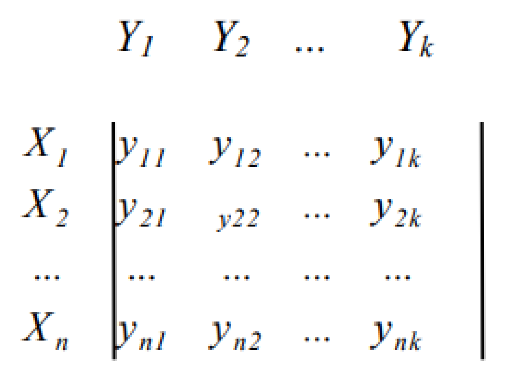
In cases of multi-criteria negotiation, a set X is determined, representing the decision variants Y = {Y
1, Y
2, …, Y
n}. These variants are evaluated according to established criteria X
1, X
2, …, X
k. Each variant Y
i, i = 1, 2, …, n is described by a vector named according to the determined criteria of criterion values (x
i1, x
i2, …, x
ik). The mathematical model of multi-criteria decision-making shows the so-called criterion matrix, it is displayed in
Figure 1. In this matrix, in the i-th column is the vector of the variant Y
i criterion values, and the individual criteria are displayed horizontally [
26].
The matrix of multi-criteria decision making in mathematical expression is shown as follows:
Figure 1.
Multi-criteria decision matrix [
26].
Figure 1.
Multi-criteria decision matrix [
26].
The method applies to various research areas, and is very suitable for the qualitative nature of research in management and decision-making processes in general. The essence is the creation of a management selection matrix that will point out the suitability of the specified variants for specific established criteria. This analysis required the following procedure:
Determination of evaluation criteria that are based on the essential functions of the geopark and represent the points of view used in decision making;
Defining the quantification of the evaluation criteria;
Determining the scales of measuring individual criteria according to the geopark’s functional areas;
Determination of criteria variants;
Evaluation of the decision matrix by the method of selecting the dominant variant/dominant variants.
When building a multi-criteria matrix, three types of values are available, which are hereby described.
Nominal scales divide a set of variants into two or more groups, the usefulness of which are expressed simply from the point of view of a specific criterion (e.g., 1—meets, 0—does not meet).
Ordinal scales represent the number of points or scale intervals corresponding to the number of assessed variants. The numbers assigned to the individual variants only determine the order of the variants according to some criterion, but do not express their mutual ratio (size of preference). The resulting order of the variants is determined according to the total or average number of points obtained.
Cardinal scales make it possible to express not only the order of variants, but also the mutual ratio of their usefulness (we consider the most favorable value for each criterion to be 100%, and the usefulness of the others is expressed as a proportionally lower percentage) [
26,
27].
The essence of the evaluation process is the section of the suitable variant for the established criteria. The classification of variants aims to divide the variants into several classes, which Jablonský stated as follows, and at the same time, he states that when comparing two variants, the following variants can occur:
An ideal variant (achieves all the best possible values);
A basal variant (reaches the minimum values, is the opposite of the ideal variant);
A dominated variant is when one can find a variant that is better or at least equally good in all criteria;
A non-dominated variant for which the previous statement does not apply is the so-called non-dominated, a variant for which no variant dominates it according to all criteria; there are usually several non-dominated variants [
26,
27].
Compiling criteria into individual management areas was necessary during the selection method. The categories of these areas are based on the functions that the geopark must fulfill. The basis for determining specific criteria was the study of foreign professional and scientific articles that dealt with the functioning of geoparks in the EGN and GGN (UGG) networks. They depicted how important geoparks function, their activities and functions, the description of which was contributed by influential experts and authors in the field of geoparks, such as José Brilha, N.T. Farsani, R.K. Dowling, D. Newsome, C. Coelho, C. Costa, P.J. Mc Keever, N. Zouros, I. Valiakos and others [
3,
6,
7,
9,
18,
28,
29,
30,
31,
32,
33,
34,
35,
36,
37,
38,
39,
40,
41]. The supporting element in the analysis, but also the determination of criteria for the creation of a new management model, was the form used in the process of accepting and evaluating geoparks into the Global Geoparks Network, currently called the UNESCO Global Geopark, entitled “Self-Evaluation Checklist for aspiring UNESCO Global Geoparks (aUGGp)” [
42], based on which the criteria were adopted.
Four criterion-based areas consisting of partial criteria were chosen. These four areas were based on essential functions, and depicted four areas of activities and activities requiring effective management. They represented the area of protection and geoconservation, which includes creating a protection strategy, specific activities ensuring protection and geoconservation, and activities related to research and creating valuable educational materials. The second field of criteria was geotourism, which includes the creation of geotourism sites and routes; the creation of geotourism infrastructure; the operation of information points; the design and implementation of projects in this area; and the creation of modern geotourism programs for various target groups. The third group consisted of activities aimed at education, the creation of educational goals, educational programs, cooperation with educational institutions, and offering educational activities for geopark residents. The fourth criterion, the development of the territory, consisted of activities such as promoting the territory; cooperation and coordination with local entrepreneurs, developing the territory through projects; and increasing employment and improving the territory’s infrastructure. The choice of criteria was conditioned by the creation of suitable variants, where different types of management were grouped. After the criterion-based evaluation of the geopark activities, it was necessary to define the quantification of the criteria, that is, to express it numerically for better processability.
In the selection method of suitable management for geoparks, it is necessary to create two matching matrices; the task of the first matrix is to search for an ideal and dedicated type of usable management for geoparks. In this case, we do not assign a degree of importance to the criteria, but only choose the nominal values 0 and 1, thus, assigning whether the given management meets or does not meet the set criteria. Suppose it is impossible to find an ideal variant suitable for managing the geopark. In that case, we will subsequently create an identical selection matrix, which, based on assigning weights to individual criteria, will determine which type of management or which combination of management suits the geopark and its management environment. For the evaluation process, values 0 and 1 were chosen (confirming the suitability for the given criterion and rejecting it for the given criterion); the value 0 means that the given variant of management is not suitable, and the value 1 means that the type of management is suitable for the criterion. The group of criteria in individual areas was determined during the research in no order of importance; the authoritative information for us was whether a specific management variant was suitable for a given criterion. Determining the variants represented the determination of different types of management. The essence consisted of obtaining points for individual management variants; the maximum possible number obtained represented the total sum of the criteria established for the evaluation selection matrix. The essence of this method is to determine the most suitable variant of management for a given area, or a combination of management for different areas of management. There is also the possibility that several variants are suitable for one criterion; one variant does not exclude the other. The task of this matrix is to find the ideal variant of suitable management for the geopark. The ideal variant confirms values in all criteria, i.e., values.
Suppose the first matrix needs to show us the ideal variant suitable for managing the environment of the geopark. In that case, it is necessary to continue creating a second identical matrix by expanding it through adding the weights of individual criteria, which will help identify a unique management model suitable for the given environment. The scales express the importance of individual criteria according to the system of evaluating geoparks in the Global Geoparks Network. The first selection matrix with a nominal expression of values was the basis for recalculating the weights for criteria and variants. Adding weights to the second matrix helps display the most suitable management types for the geopark. The weights were determined based on a point evaluation process that was adapted to the established criteria of this selection method, inspired by the geoparks evaluation process in the EGN and GGN networks. The method of selecting the dominant variant or dominant variants was used to evaluate the matrix, which represents the filtering of variants and, subsequently, the selection of variants, which can be a grouping of different types of management. The result is the selection of management that subsequently creates a suitable management model for the geopark.
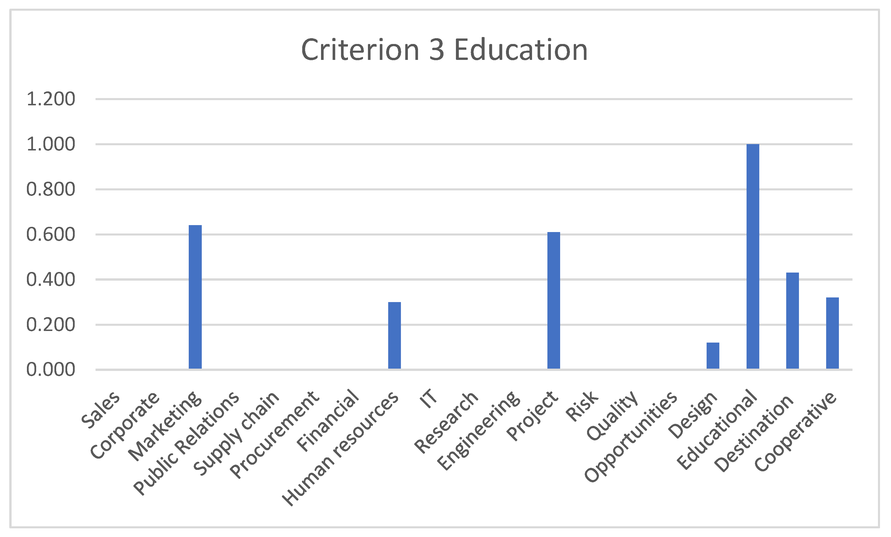
When creating the matrix, four criterion areas were determined in a vertical line, namely the following:
Criterion decision area 1—Protection and geoconservation, contains eight criteria ranging from 1A to 1H;
Criterion decision area 2—Geotourism, contains nine criteria ranging from 2A to 2I;
Criterion decision area 3—Education, contains eight criteria ranging from 3A to 3H;
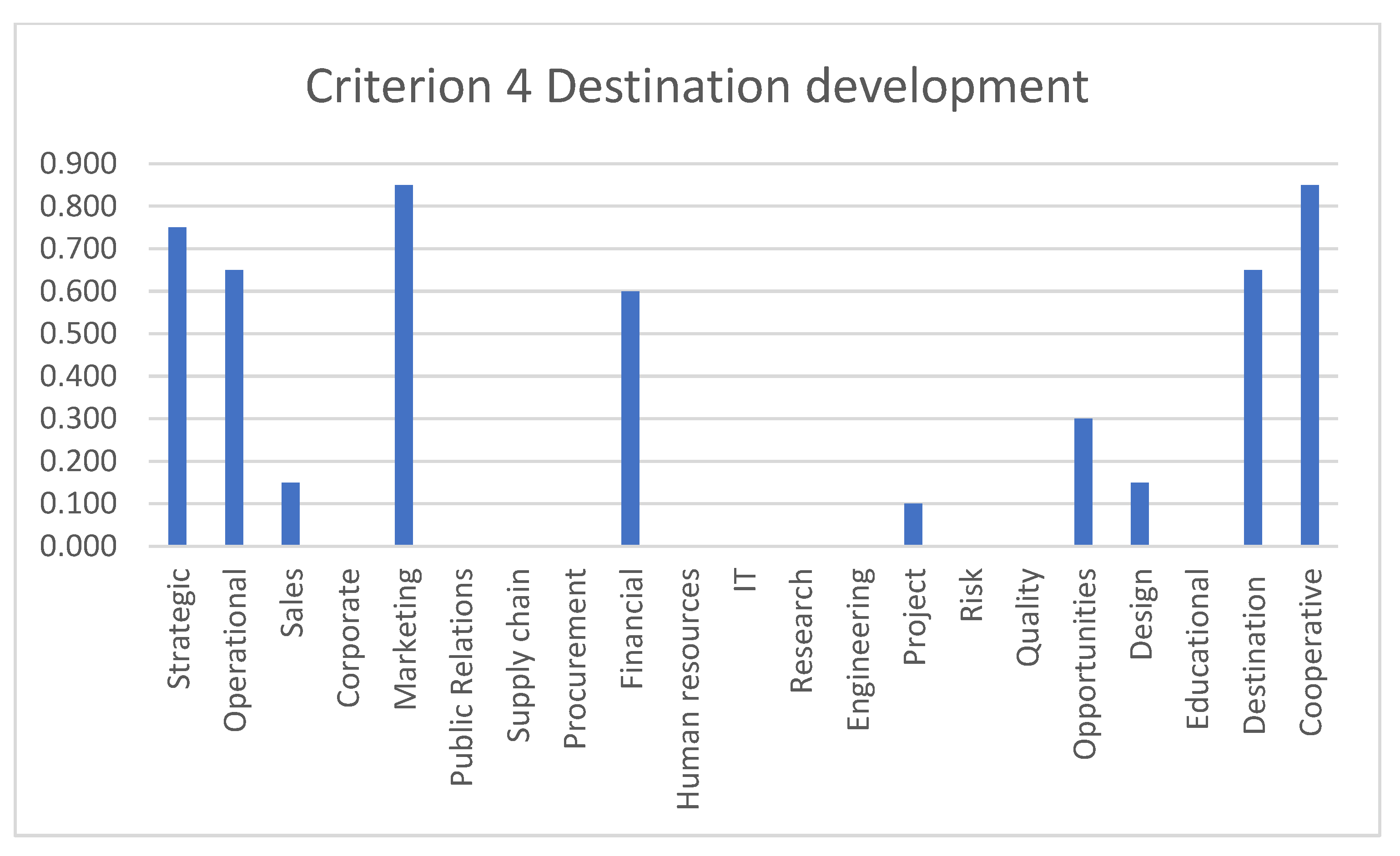
Criterion decision area 4—Territorial development, contains six criteria ranging from 4A to 4F.
When choosing the variants, 21 management variants were determined in the matrix indicated by the designation V1 to V21 in a horizontal line. The types of management were chosen according to whether they were related to the activity of the geoparks, or at least partially affected it.
The selection matrix effectively deals with choosing variants evaluated according to several criteria. A significant positive of this method is the multi-criteria nature of decision-making problems, the non-additivity of the criteria, the suitability of use for a mixed set of criteria and its usability in evaluating qualitative data. It is necessary to point out the fact that although the creation of the selection method was based on professional articles in the field of geoparks functioning, the sources still need to indicate a specific management model or management structure in the geopark. The authors analysed activity, activities and case studies, but none specified a management model that was generally suitable for geoparks. It is desirable to deal with the issue of management from this point of view and to define the model and structure of management, which is also the goal of this method and article.
The primary purpose of a geopark is to safeguard the environment and natural features of the area, which involves promoting geoconservation and protection and facilitating scientific research within the geopark. Scientific research cannot be excluded from the function of a geopark because it is necessary to know what values the given territory offers, in what way they need to be protected, and, at the same time, presented to preserve their original value as much as possible. Another critical function is education and raising society’s awareness of the need for nature protection. Education is understood for all age categories of visitors; the lower the age category that is addressed, the more effectively the information will be processed. Education in early childhood fundamentally influences a person, and affects his future behavior in adulthood. This fact is crucial for raising awareness of society in any field. Marketing is an integral part of geopark functions, due to the presentation of the territory and visibility. Even in the case of the functioning of all other areas in a geopark, which would fulfill their functions, effective marketing and promotion are necessary to ensure the overall prosperity of the geopark. Considerable attention must be paid to fundraising, since it affects the geopark’s plans, functioning and existence. The goal of every creative activity is to achieve efficiency and fulfill goals. In this case, achieving such an outcome depends solely on having a skilled workforce. Since personnel coverage and partnerships participate in achieving the goals, the selection of workers and people involved in the activity of the geopark influence the overall result of functioning with their personality, experience, qualities, enthusiasm and status.
2.1. Determination of Criteria According to Functional Areas in Geopark Management
Definitions of partial activities (areas) in the decision-making process of the geopark according to the functions that the geopark must fulfill (individual criteria were chosen based on the activities resulting from the four essential functions of the geopark) areas described in the following sections.
2.1.1. Protection and Geoconservation
The following table (
Table 1) describes the main attributes (activities) from the functional area of protection and geoconservation of the natural environment, which contains scientifically or otherwise significant locations and territories from the point of view of geology, geomorphology, archaeology, history and culture. These characteristics are specific to the given territory, and represent values that need to be protected and preserved in the most original state possible for future generations. However, the protection of geolocations is also related to the protection of associated values that are related to the geolocation, such as historical and cultural values of the environment. Of course, part of protection also involves the area of research, which should constantly be carried out in the locality; this ensures and proposes methods and conservation values that would be sustainable in the given environment.
2.1.2. Geotourism
The presentation of the geopark territory in the form of geotouristic activities repre-sents an acceptable and sustainable way to combine rest, recreation, education and nature protection. It is a soft form of tourism, which primarily ensures an acceptable way of using the territory in the spirit of sustainability. The management of geotouristic activities and geotouristic infrastructure represents a wide range of activities, which are shown in the main lines in
Table 2. From the point of view of geopark management, we understand the provision of geotouristically attractive locations for potential visitors. This means creating geotouristic routes, and geotouristic infrastructure. Infrastructure in this sense needs to be divided into general and geopark infrastructure (tourist infrastructure). One of the key planning and management activities in this area should be cooperation with service providers, in order to increase the level of geotourism offered. The geopark’s cooperation with external entities represent secondary tourism offerings in the area, which helps the overall development of the area and improves the quality of services.
2.1.3. Education
The key area for securing the idea for which geoparks are founded is education. It represents a factor without which is not possible to carry out full-fledged other func-tions in the geopark. A geopark, as an educational element in education, should occupy a stable place and present the geological heritage in a modern, interesting and engaging way.
Table 3 shows a view of the activities from the point of view of the education function. For geoparks, this represents not only specific educational products for educational facilities, but also provides the task of educating society. To fulfill this task, it is necessary to organize various educational and presentation programs, seminars, excursions and games for a wide range of target groups, from preschool children to the general public. They emphasize the education of visitors, residents of the territory of the territory, including programs for schools, and offer guide services. As in all functional areas of the geopark, cooperation with educational institutions for the creation of modern teaching methods and contemporary geological heritage is important. Cooperation needs to be clearly defined; it addresses who the geopark will address, and what it can say to them.
2.1.4. Development of the Territory
One of the functions of a geopark and its management is the development of the geopark’s territory. We understand this development as regional development, increasing the economic level of the inhabitants of the territory. Geoparks are an important representative of the given region, and in addition to their own activity, they should stimulate the creation of subsequent activities in the secondary sphere (services). Activities from the point of view of the development of the territory as a functional area are shown in
Table 4. The cooperation of local entrepreneurs, self-government, residents and surrounding spheres is an essential part of the successful functioning of the geopark, and raises the socio-economic level of the given location. The role of the geopark in this target area is to ensure such management increases the employment; supports the regional products; creates and implements projects for the development of the territory; creates conditions for cooperation between the actors of the geopark and the actors of catering and accommodation establishments; and also aims to create partnerships within the territory and outside it to support the further development of the territory (networking). All of these tasks would not be possible without effective marketing support, not only for local products, but also for the entire territory.
Considering the diverse structure of activities, the following variants of standard types of management were determined, which are commonly used in companies and organizations (the types of management, that is, the variants, were chosen according to whether they were related to the activities of geoparks, or at least partially affected them):
V1 Strategic management;
V2 Operational (operational) management;
V3 Sales management;
V4 Business management;
V5 Marketing management;
V6 PR management (public relations);
V7 Supplier management;
V8 Procurement management;
V9 Financial management;
V10 Personnel management;
V11 Information technology management;
V12 Scientific and research management;
V13 Engineering management;
V14 Project management;
V15 Risk management;
V16 Quality management;
V17 Management of opportunities;
V18 Design management;
V19 Educational management;
V20 Destination management;
V21 Cooperative management.
The process for creating the methodology for the article is shown in
Figure 2.
4. Discussion
The results of the selection matrix with nominal values and the selection matrix with determination of weights show us that there is no single type of management that would be optimal for managing a geopark.
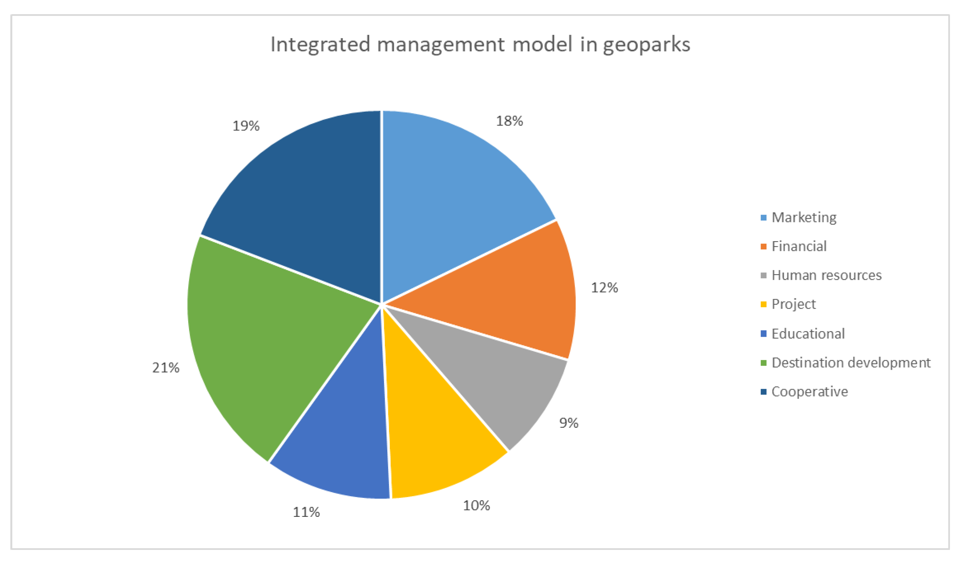
The conclusions resulting from the selection method were the basis for creating a suitable management model applicable to the management environment of geoparks. Defining the criteria of functional areas and management variants created a selection of suitable variants. For geopark management in the selection matrix, several types of management were suitable in different degrees. Therefore, it is desirable for a clear structure to select the most dominant types that represent the means of management. The management structure and its requirements are guided by the following model, compiled from the most dominant management. When we talk about geoparks, geotourism or sustainability, there is integration. This concept will also describe the created model, the essence of which is the connection of parts into a single whole, with consolidation, wholeness, unification and grouping of individual types of management into one functional unit. For a geopark, this means focusing on more types of management for individual activities. The theoretical basis is the so-called integrated management model. In practice, a geopark requires quality professionals who would apply these management methods depending on needs which currently need to be addressed. Quality and well-founded staff means quality and efficient management. The specific results of the selection matrix are shown in the following pie chart, which combines key management aspects into an extended, integrated whole.
Values were selected from the final values of the second selection matrix, where variants were selected that had values higher than ¼ of the total value of the sum of weights in all criterion areas. Variants with a value higher than 1 were chosen for the resulting integrated model of the management structure in
Figure 8, because these represent a dominance that is higher than 25%.
The model shows the following management structure in the composition of variants related to marketing management, finance, project management, destination management, education and personnel issues. The management structure reflects the needs of the geopark. It shows the areas in which management should focus to achieve the desired goals—underestimating any area of management results in a reduction in the quality of activity, inefficiency, or even the inability to achieve any of the goals.
In short, this model shows the three most dominant variants in
Figure 9. These management ratios were balanced, almost identical and with minor deviations. The geopark management needs to be ensured, 36% by destination management, 33% by cooperative management and 31% by marketing management. The following graph shows the management model, cleared of previous sub-management aspects.
Even though the nature and behavior of a geopark is in some ways similar to business and corporate management, with the difference that the business generates profit and thus prospers, the geopark, on the other hand, shows prosperity in the form of cooperation, not competition, by creating purposeful partnerships that ensure the protection and development of the territory. This model confirmed the need to manage geoparks as destinations that bring profit to a territory in the form of increasing the standard of living and awareness of the population; improving and protecting the environment; and a strategy of sustainability and overall added value of a geopark for the territory where it is located. From the confirmed conclusions and the created model, geoparks can draw knowledge and create directions in management. The positive aspect of the model is its universality, which means that it can be used by changing and adapting the criteria to different forms of tourism, considering their specificities.
It is difficult to compare this research with others, because there are no existing studies that focus on the research of suitable and comprehensive management approaches for geoparks. Many studies describe existing management practices [
43,
44,
45], analyze the management of geosites in geoparks [
46] or analyze the certification and revalidation schemes of UNESCO [
47,
48], but they do not examine it from a management theory perspective. We aim to highlight the results and, based on them, propose suitable management approaches for geoparks. Additionally, we propose an integrated management model, which represents a hybrid form. This management model includes the so-called “management mix”, which allows for the selection of management strategies that are suitable for specific areas of a geopark.
5. Conclusions
Geoparks, with their concept and functioning, represent a modern approach to protecting natural heritage; it is essential to pay considerable attention to their management. Although each geopark has a unique structure, operation and activities, their functions remain the same. This article points out that the diversity of the environment as an organizational unit and its goals require constant adaptation of the management method and the use of different types of management. There is no geopark for which only one type of management is suitable, so it was necessary to show what the management structure should be, which applies to all geoparks. An essential step of the research involved determining the method of selecting the appropriate types of management for the geopark. The method can be applied to any decision-making area related to geoparks, which provides added value. Another positive is the topicality and complexity of the topic. It should be added that there currently needs to be a model for managing geoparks defined in such a way. None of the authors dealing with geoparks has created a similar model describing the management in the way presented in this article. The structure’s design can be used in creating plans, strategies and sub-activities.
The management structures shown create a comprehensive picture of geopark management, based on which geopark stakeholders can draw inspiration when defining and creating management plans and areas. At the same time, it is possible to use the method of the decision-making process in any aspect of the management process. This research offers a diagram of relationships and attributes in which the geopark is located, in order to understand the management environment. Based on this, it is possible to establish a communication and cooperation strategy for effective results. Defining individual types of relationships and involved aspects helps to understand this control unit’s specifics. It is necessary to move towards planning an effective process and a detailed knowledge of its properties, a prerequisite for successful management. This article also revealed an important finding that, even though a geopark often resembles corporate management in its organization and activities, it is necessary to apply destination management in combination with cooperative management to achieve goals in all four functional areas. Suppose the geopark uses destination management as a form of management. In that case, it is necessary to ensure strong ties to the private sector through cooperative management, which, in this case, is a key supporting component. The proposed model represents a hybrid and integrated form of management, consisting of key types of management that analyses proved to be the most beneficial and important. It is necessary to realize that the initiative to create geoparks, which primarily originates from local communities, needs support and a helping hand in building this modern and unique product of geotourism.
This research aimed to create a valuable whole that comprehensively presents the management of geoparks, and the benefits in both theoretical and practical terms include the following:
Analysis of management areas in geoparks—defines geopark functions and categorizes them into four functional areas. It defines the essence and goals of these areas, and highlights what is crucial for management.
Defining the management environment in which the geopark is located and the attributes related to it defines the components of the management environment of the geopark, defines the properties of the environment in which the geopark is located, and names the entities entering into relations with the geopark, as well as their position and purpose in this environment.
Creation of a selection method for the decision-making process in geoparks: defining activities in the geopark from the point of view of functional areas in the form of criteria and their relationships to individual types of management, depicting possible variants of management in the geopark.
Creation of a general model of the management structure for geoparks: defining key management variants and their relative positions.
The categorization of functional areas and the analysis of individual activities for creating operational plans and sub-goals that can be used.
It is possible to use the established criterion areas and their criteria in creating sub-plans according to the criteria in the selection matrix.
It is possible to use the selection method and its universal model in decision-making processes in any field.
The conclusions of the selection method and the direction of a suitable management method in individual areas can be used further.
The selection method may be used in other tourism sectors (e.g., mining tourism) by choosing adequately adapted criteria that are specific to the given area.


 ,
, 


