Article

Stormwater Quality and Long-Term Efficiency Capturing Potential Toxic Elements in Sustainable Urban Drainage Systems—Is the Soil Quality of Bio-Swales after 10–20 Years Still Acceptable?

by
Floris Cornelis Boogaard
1,2,*,
Guri Venvik
3 and
Allard Hans Roest
1
1
Research Centre for Built Environment NoorderRuimte, Hanze University of Applied Sciences Groningen, Zernikeplein 7, P.O. Box 30030, 9747 AS Groningen, The Netherlands
2
Deltares, Daltonlaan 600, P.O. Box 85467, 3508 AL Utrecht, The Netherlands
3
Geological Survey of Norway, P.O. Box 6315 Torgarden, 7491 Trondheim, Norway
*
Author to whom correspondence should be addressed.
Sustainability 2024, 16(7), 2618; https://doi.org/10.3390/su16072618
Submission received: 3 January 2024 / Revised: 13 March 2024 / Accepted: 17 March 2024 / Published: 22 March 2024

Abstract

:
Sustainable urban drainage systems (SuDS) or nature-based solutions (NBSs) are widely implemented to collect, store and infiltrate stormwater. The buildup of pollutants is expected in NBSs, and Dutch guidelines advise monitoring the topsoil of bio-swales every 5 years. In the Netherlands, almost every municipality has implemented bio-swales. Some municipalities have over 300 bio-swales, and monitoring all their NBSs is challenging due to cost and capacity. In this study, 20 locations where bio-swales with ages ranging between 10 and 20 years old were selected for a field investigation to answer the following question: is the soil quality of bio-swales after 10 years still acceptable? Portable XRF instruments were used to detect potential toxic elements (PTEs) for in situ measurements. The results showed that for copper (Cu), zinc (Zn) and lead (Pb), 30%, 40% and 25% of the locations show values above the threshold and 5%, 20% and 0% above the intervention threshold, meaning immediate action should be taken. The results are of importance for stakeholders in (inter)national cities that implement, maintain, and monitor NBS. Knowledge of stormwater and soil quality related to long-term health risks from NBS enables urban planners to implement the most appropriate stormwater management strategies. With these research results, the Dutch guidelines for design, construction, and maintenance can be updated, and stakeholders are reminded that the monitoring of green infrastructure should be planned and executed every 5 years.

1. Introduction

Urban watercourse degradation, increase in runoff volumes, peak flows and nutrient and element pollution to urban stormwater are just some of the results of climate change [1] and the rapid urbanisation on our water systems. Urban stormwater contains pollutants emitted from several sources such as traffic-related emissions (engine, tire wear, vehicle bodywear, and brake linings), the leaching of building materials and activities such as industry, commerce and construction [2,3,4,5]. Aside from the water, stormwater has been found to include sediment, litter, oxygen-demanding substances, bacteria, viruses, (in)organic pollutants, including polycyclic aromatic hydrocarbons (PAHs), and potential toxic elements (PTE) [3,6] at levels that often exceed national and international environmental quality standards [7,8,9]. Of all these pollutants, elements such as lead (Pb), copper (Cu), and zinc (Zn) are considered to be of great concern in urban waterways around the world [10]. These elements are all primarily sourced from uncoated roofs, infrastructure and carparks [11,12,13]. Summarizing, material use in our built environment and transportation systems can directly impact the quality of urban soils and waterways.
The widespread implementation of bio-infiltration, such as raingardens and bio-swales, comes with concerns that green infrastructure may pose a risk of pollution to the underlying groundwaters or nearby waterbodies [12]. Topsoil quality in bio-infiltration can be degraded by the accumulation of pollutants, causing the mobility of substances to deeper groundwater layers that are used for drinking water. The reduction in risk is dependent on the efficiency of the bio-filtration, the stormwater quality and pollutant removal efficiencies. Filtration and sedimentation within the grass layer are the primary mechanisms of pollutant treatment [9,14], where particle-bound pollutants show the highest removal efficiency via bio-swales [6].
In the Netherlands, potential toxic elements in runoff water may either be dissolved in the water or particle-bound, with binding percentages of the following elements: copper 65%, lead 70% and zinc 80% [15]. Infiltration and vegetative filtering will remove dissolved elements and elements bound to particles in addition to sedimentation in the bio-swale [16]. Adsorption to soil particles takes place predominantly in the upper 0–30 cm. The highest concentrations of toxic elements are commonly found in the upper 5 cm of the soil and decrease rapidly with depths [17,18]. Factors like the embankment age and density have been shown to contribute to the concentrations of pollutants [17,19,20]. Bio-swales are the recipient of runoff water with high concentrations of pollutants, such as nitrate and chloride, potential toxic elements (cadmium (Cd), Cu, Pb, Zn) and polyaromatic hydrocarbons (PAHs) [21]. The ability of bio-swales to provide water quality treatment is documented worldwide [6,7,22]. Previous studies have identified the removal efficiency to be between 62 and 76%, 58 and 92% and 71 and 94% for Cu, Pb and Zn, respectively, though studies from a variety of regions [21,23,24].
Bio-swales have a higher efficiency of retaining PTE and PAHs by 20% and 29%, while for chlorides and nitrates, the efficiency is lower by 4% and 16%. The constant receiver of pollutants may saturate the surface soil layers in the green infrastructure and thereby make it less efficient as removal media with time. This may contribute to the pollution of underlaying groundwater or surrounding waterbodies [25]. Elements associated with particles are generally trapped in topsoil sediments, bonding to organic matter in the soil or soil clays [26,27]. Immobilized metals can be released through chemical and biochemical dissolution reactions in the infiltration water, and these dissolved metals can be partly assimilated by plants and microorganisms [7,26].
In this study, the locations of 2000 bio-swales in the Netherlands are reviewed with the open-source NBS platform climatescan.org. Among the information about the NBS is the year of implementation, where the oldest bio-swales were selected for further monitoring. Out of the 2000, 20 locations, all implemented in the early 2000s, are measured with a portable X-ray fluorescence spectrometer (pXRF) to evaluate the concentration of the most critical potential toxic elements copper, zinc and lead. The measured values are further compared to national threshold values. The pXRF mapping is executed systematically which gives an insight into the distributions of elements and concentration according to the flow path of water in each bio-swale [28,29,30].
The returning question regarding green infrastructure is as follows: ‘Is the soil quality of bio-swales after 10–20 years still acceptable?’. This is an important question to be answered for organisations who are responsible for the maintenance of green infrastructure and relates to cost-effective monitoring and maintenance to keep health risks as low as possible.
The answer to this question can depend on the local situation and legislation. For this reason, we give insight into the typical bio-swale implementation in the Netherlands and also present the stormwater quality database where concentrations are compared with Dutch stormwater quality levels and the maximum allowed concentrations (MACs) for potential toxic elements [31].

Typical Bio-Swales in The Netherlands

Dutch bio-swales are often vegetated channels designed to store and infiltrate stormwater runoff with the removal of pollutants. They are used as retention basins that treat runoff stormwater via sedimentation and infiltration where soil and groundwater conditions allow infiltration. Note that the Netherlands is in a unique position on a delta, with nearly two-thirds of the land lying below mean sea level. The level of the groundwater in these areas often lies just a few decimetres below roads, and the soil often consists of low-permeable soil such as clay.
The main type of bio-swale used in the Netherlands is the ‘standard conveyance swales’, which is a ‘dry swale’ [32] as illustrated in Figure 1. Dry swales are equipped with a filter layer of high-permeable soil overlaying an underground drain system. Dutch bio-swales can have a combination of two main goals: (1) a transportation channel for excess water and (2) infiltration retention basins.
Some typical facts and figures of Dutch swales can be derived from the Dutch guidelines in Table 1, which are related to five primary factors that affect the performance of bio-swales such as the vegetation type, percentage of vegetation cover, treatment length of bio-swales, slope and soil type [14,33]. All monitored bio-swales in this study are designed after these national guidelines.

2. Materials and Methods

2.1. Mapping Bio-Swales

ClimateScan is an open-source toolbox giving the exact location of green infrastructure with the possibility to upload website links, downloadable photos and film material, established in 2014 [34]. As of 2024, the database has close to 10,000 unique visitors yearly, and over 3000 Dutch locations with green infrastructure (bio-swales and raingardens) are mapped providing not only information on the location but also their age supported with photos and videos. The 20 locations selected for the monitoring of their long-term efficiency are shown in Figure 2. All selected research locations are verified with the municipalities. More information on the selected bio-swales is accessible on www.climatescan.org with the exact location.

2.2. Database of Stormwater Quality

Stormwater quality data are gathered in a Dutch national database, reachable for all interested parties [31]. Most of the samples are grab samples analysed in certified laboratories according to Dutch standard quality control procedures. Each entry in the database includes information such as site descriptions, (land use components, municipality), sampling information (sample type, date, season, sampling method) and the aim of research with links to the original research articles and reports. The stormwater quality database is focused on urban areas, structured after areal use such as areas of trade/commerce or residential areas.
The database presents stormwater pollution levels at 191 locations throughout the Netherlands, recording monitoring data of 1742 individual events after 1999. Different water quality parameters were characterized through the calculation of median, minimum, mean, maximum and 90th percentile values. Additional information and recommendations for improving the quality of monitoring are also part of the report presented with the stormwater database. Each individual monitoring event has gone through a quality control review based on sampling methods, a review of the analytical methods, extreme values and relationships among parameters [15]. A comparison is made between the Dutch quality standards’ maximum acceptable concentration (MAC) for receiving waters [31] and the recorded concentrations of the pollutants from the database.

2.3. Selection of Bio-Swale Locations

The criteria for the selection of localities were firstly based on the age of construction, with the hypothesis that the oldest bio-swales would be the most polluted. The criteria of areal use were recorded during the field investigation. The field investigation was executed in May 2018. The 20 selected locations are listed in Table 2 which presents the year of construction, type of area for location and geographical location. In addition to this information, for each location, an online link to ClimateScan has been added that provides more information on the measures (e.g., videographic material, dimensions, additional monitoring data etc.).
In addition to the data of the individual bio-swales, desk research was used to determine the land use around each location. In this, analyses, aerial photographs and national registries on building ages and usages were used to evaluate potential sources of pollutants in the direct vicinity of the measures, these values being (1) traffic intensity and parking, (2) building ages and (3) roofing type. This information is included in the results of this study.

2.4. In Situ Measurements of Potential Toxic Elements (PETs) with Portable XRF

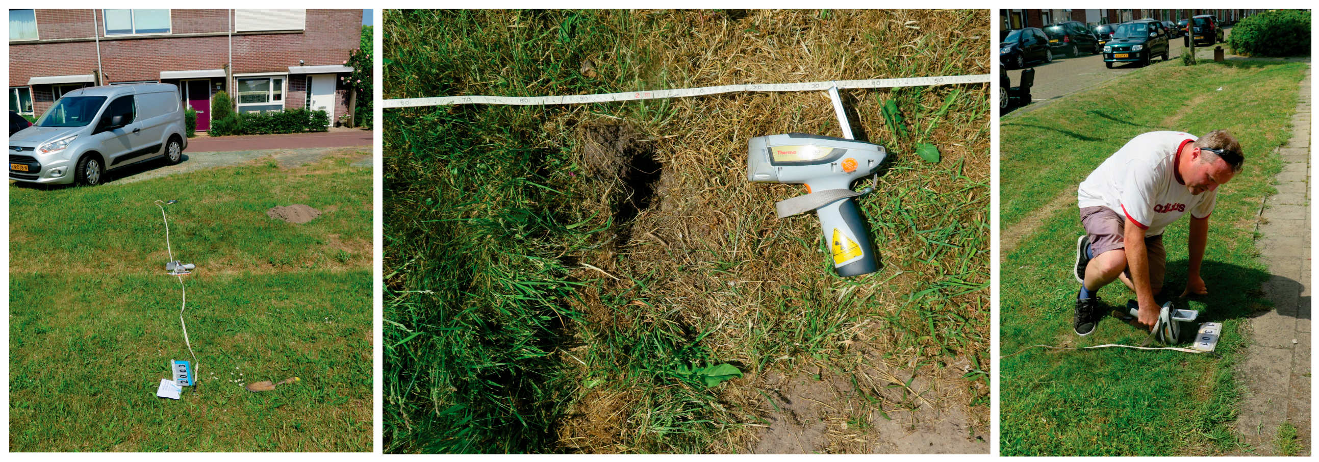
Portable fluorescence spectroscopy (pXRF) is a handheld instrument with a technique for chemical composition measurements. pXRF analyses cover the element content in the periodic table from magnesium (Mg, 12) to uranium (U, 92) (ThermoFisher, and www.thermofisher.com). Measurements with pXRF were executed on the topsoil (0–3 cm) along profiles with 1-metre interval measurements of 60 s. Two instruments, Thermo Scientific Niton XL3t GOLDD XRF and Thermo Scienctific™ Niton™ XL3t GOLDD+ XRF Analysers (#SN67136), were applied in the field. Soil samples were collected for quality control of the pXRF measurement at the same location and depth (also 0–3 cm) for lab analysis. The in situ pXRF method has been published [35], and the principle is visualised in Figure 3 at the bio-swale in Lieven de Keystraat in Almelo, site 8 in Table 2.
To evaluate the environmental and health risk for the potential accumulation of PTE in the bio-swales, the measured concentrations are compared by Dutch threshold values [36] (Table 3).

3. Results and Discussion

3.1. ClimateScan as a Toolbox

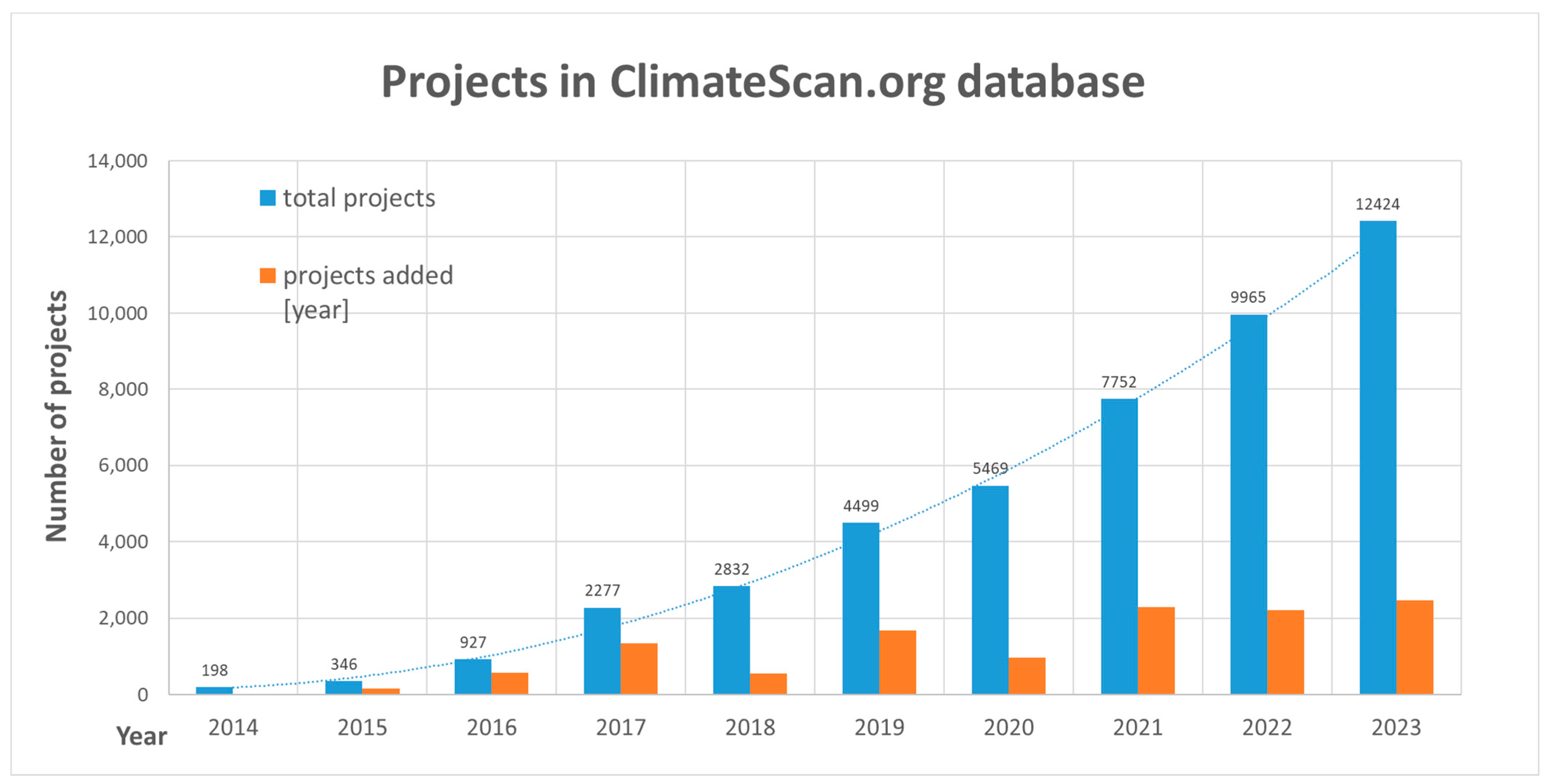
Since the establishment of the open-source toolbox ClimateScan in 2014, the number of mapped NBSs and green infrastructure has increased rapidly. At present, the toolbox has over 2000 contributors from various countries, growing each year, as shown in Figure 4.
Most municipalities have no overview of bio-infiltration locations with essential information (dimensions, age, footage). The lack of overview explains the lack of monitoring and maintenance according to the Dutch guidelines. The involvement of municipalities in mapping or updating their NBS projects on the open-source platform has been very useful in selecting and monitoring bio-swales in this research and will be used in future research. Since ClimateScan is based on ‘citizen science’, verifying the locations and additional information with municipalities is essential before monitoring.

3.2. The Stormwater Database

The contaminant concentration levels are summarized in Table 4. Potential toxic elements such as copper (Cu), zinc (Zn) and lead (Pb) have been identified as pollutants of great concern in urban waterways globally [10] and specifically in the Netherlands since these three metals exceed water quality standards frequently. The measured stormwater runoff quality (from roofs and roads in residential areas) is compared with international research in Table 4 and shows high variation in concentrations of pollutants with high values of potential toxic elements.
An analysis of the stormwater quality, collected in the database, found that the pollution levels of potential toxic elements at many of the Dutch test sites did not meet the requirements of the European Water Framework Directive (WFD) and Dutch Water Quality Standards [31]. Table 4 shows that the stormwater quality measurements exceeded the MAC for nutrients (TKN and TP) and for copper and zinc compared to the national threshold levels [31].

3.3. Are the Oldest Bio-Swales Most Polluted?

As with most studies, this one starts with a hypothesis, and our hypothesis was that the oldest NBS must have the highest buildup of pollutions due to its time of receiving stormwater. When selecting the locations for detailed mapping, age or year of implementation was a selection criterion. Before choosing locations, other factors were not considerate such as the use of the area (residential vs. industrial), if the catchment area contains any specific contamination or any other influences that can affect the quality of stormwater and buildup of pollutants in the bio-swale.
For the bio-swales to be polluted, it must have a source of pollution. The concept from “source to sink” is applied widely within geology, especially sedimentology [39]. Finding and understanding the source of pollution is the key for keeping the soil quality of bio-swales acceptable.

3.4. pXRF Mapping

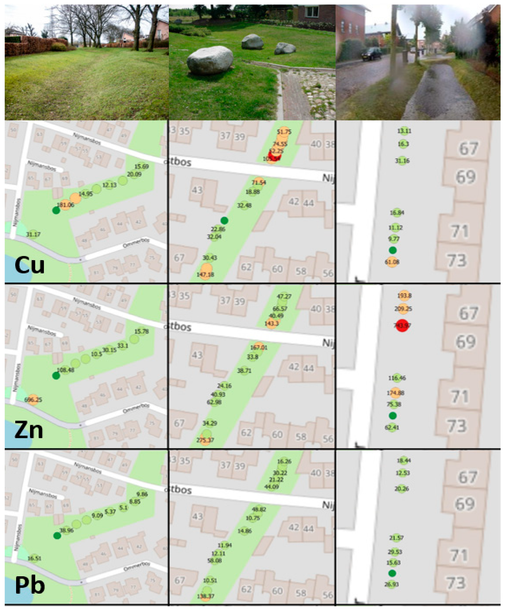
The results from the measurements with pXRF for copper, zinc and lead are compared with the national threshold values for all sites and discussed with municipalities. To answer the main research question ‘Is the soil quality of bio-swales after 10–20 years still acceptable?’, a visual answer has been made for every individual municipality as for Enschede visualised in Figure 5. It shows a picture of the sampling point and the individual concentrations of potential toxic elements with a traffic light signalling function from green ‘no action’ to red ‘action needed’ (concentration above intervention value from Table 3).
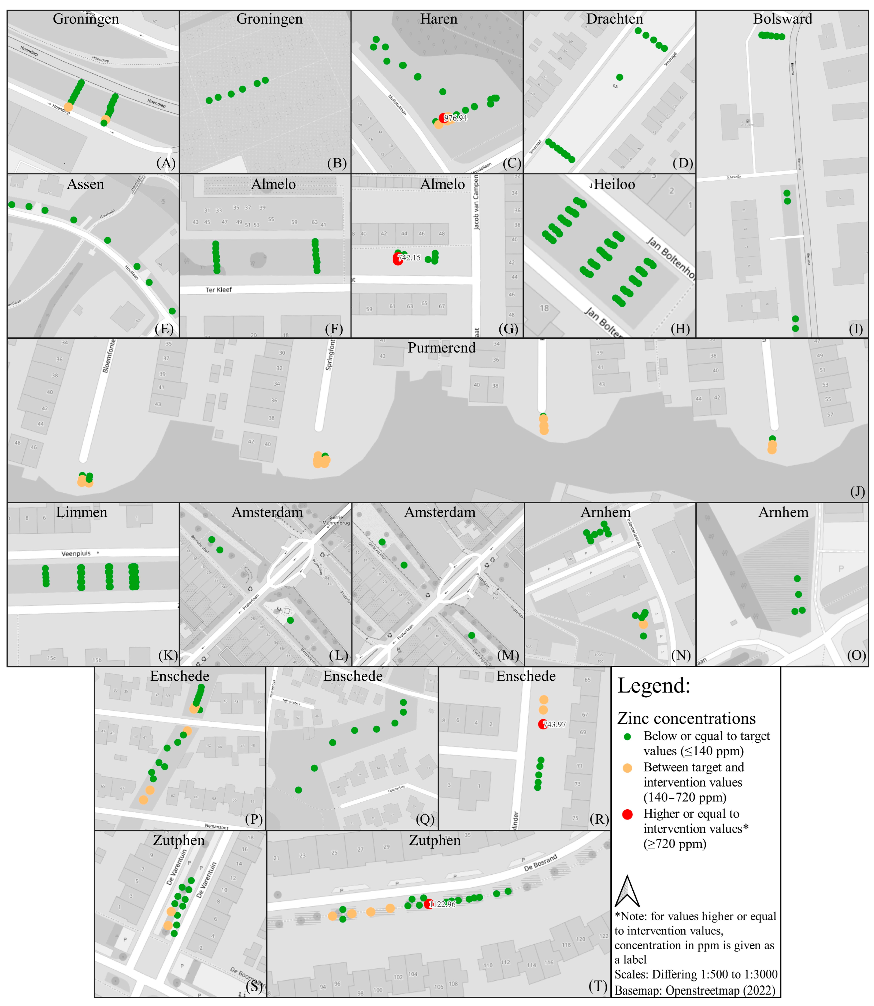
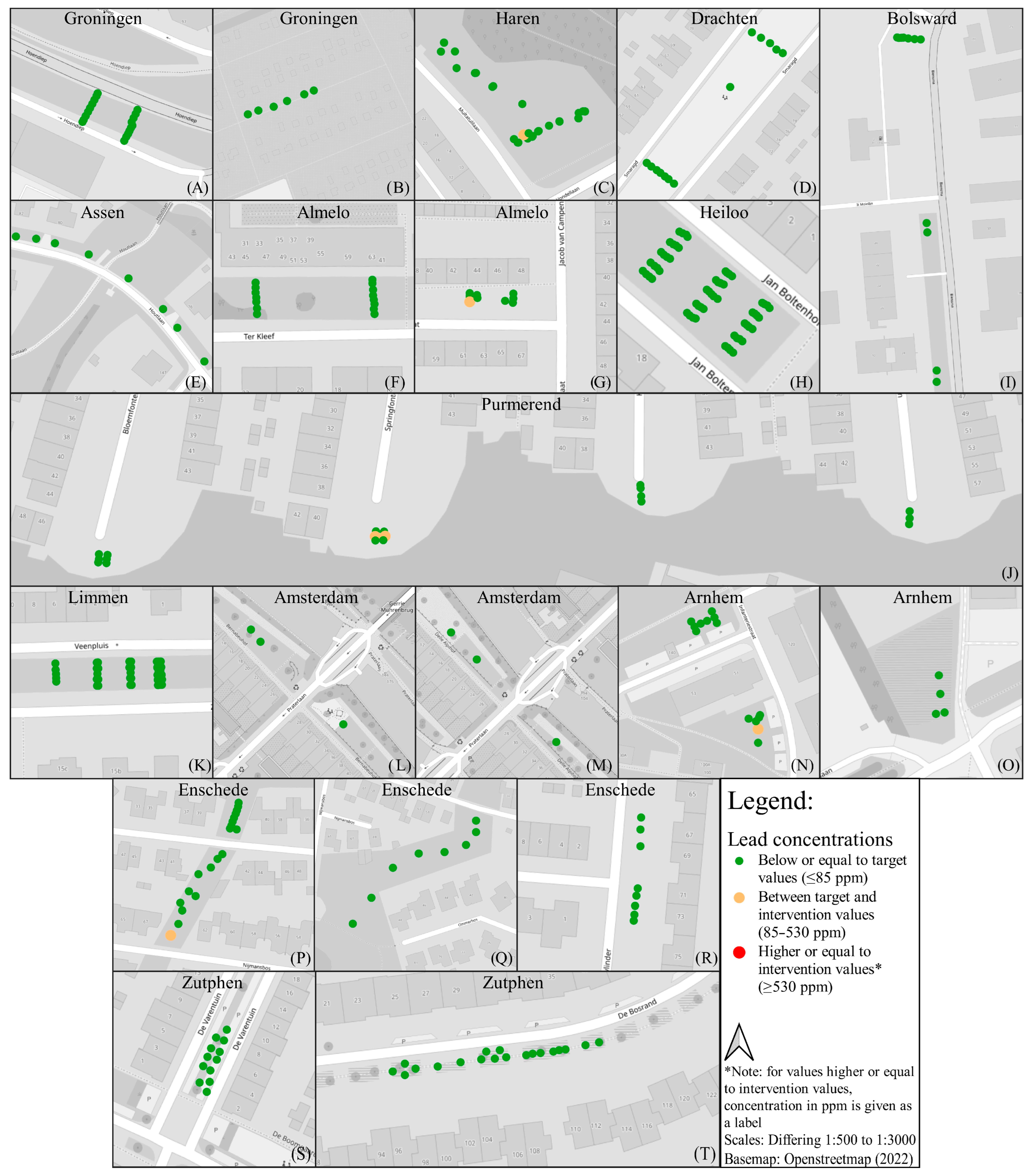
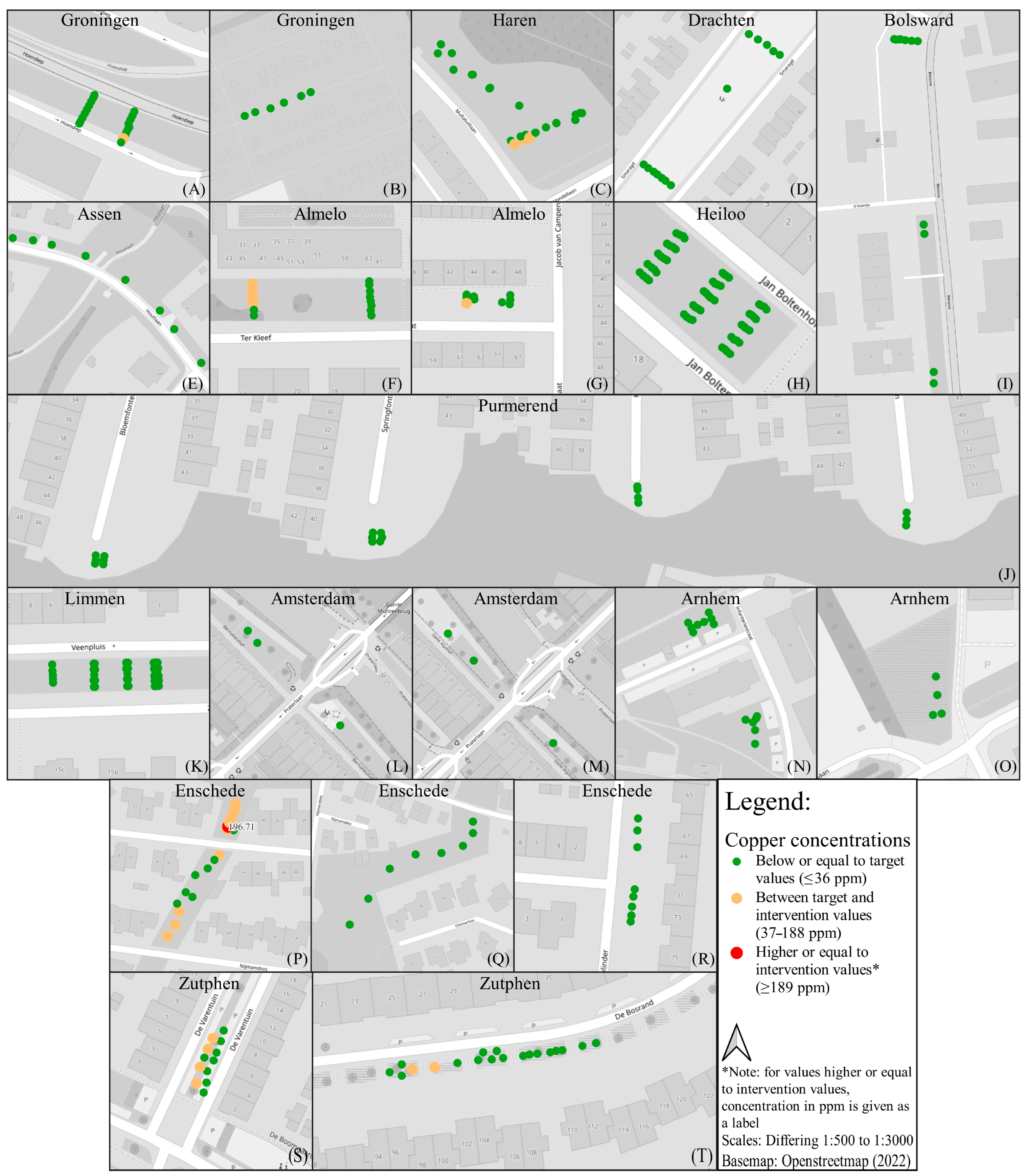
For all locations, the concentrations of zinc, lead and copper are compared to the national threshold values. In Figure 6, Figure 7 and Figure 8 the measured concentrations exceeding the national intervention values are indicated in a red colour. Green values are concentrations below the national threshold values. Yellow colours show concentrations between the target and intervention values (Table 3). The spatial distribution of the pollutants often shows a pattern with higher concentrations at the inlet from the road to lower concentrations further down the bio-swale (where less water is infiltrating).
Figure 6 shows zinc (Zn) concentrations measured in the bio-swales. The threshold value for the target value is 140 ppm (mg/kg), while the intervention value is 720 ppm (mg/kg). For zinc, 9 locations out of 20 show concentrations above the national target threshold values (yellow colour) and 4 above the intervention threshold values (red colour).
Figure 7 shows lead (Pb) concentrations measured in the bio-swales mapped. The threshold value for the target value is 85 ppm (mg/kg), while the intervention value is 530 ppm (mg/kg). For lead, 5 locations out of 20 show concentrations above the national target threshold values (yellow colour), where none (0) are above the intervention threshold values (red colour).
Figure 8 shows copper (Cu) concentrations measured in the bio-swales mapped. The threshold value for the target value is 36 ppm (mg/kg), while the intervention value is 190 ppm (mg/kg). For copper, 7 locations out of 20 show concentrations above the national target threshold values (yellow colour), where only 1 is above the intervention threshold values (red colour).
A summary of all locations where concentrations are higher than the national threshold levels for the target value and intervention value are found in Table 5. This table also shows whether there are potential sources of pollution in the vicinity of the measure such as the building age (majority of adjacent buildings), usage of buildings, roof type, adjacent road type and other relevant adjacencies. This information is derived from Google Maps, 8 cm Aerial Photographs, the Dutch National Road Registry and Dutch Registry of Buildings and Addresses.
Summarized per element, for 30% of locations (six), the target value for copper exceeded the intervention values at one location. For Zinc, 40% (eight locations) exceeded the target values, and 20% (four locations) had values exceeding the intervention values. Lastly, for lead, 25% (five locations) exceeded the target values, and no location exceeded the intervention values.
The results of the in situ pXRF mapping and potential sources of pollution in the vicinity of the measurement are discussed in a workshop with stakeholders (municipalities, water authorities, consultants and NGOs). In the workshop members, are asked for their opinion and stated the following:
(i) Interview 1 (water authority at Vechtstromen): “The conclusions from this study broadly confirm the assumptions we had 20 years ago when we started with bio-swales for water storage, groundwater recharge and purification of rainwater runoff. Bio-swales were implemented as a solution to the negative effects of sewer overflows and discharges from separate sewer systems. Not everyone is familiar with these ‘historical’ choices and effects on water management. The result of this study proves the intention of the bio-swales”.
(ii) Interview 2 (program director at STOWA): “The results of this study are in line with our expectations. In recent years, much knowledge of the quality of runoff and infiltrating rainwater in urban areas, for example rainwater from roads has been collected and made available. Many elements, such as copper and zinc, in rainwater are filtered by the topsoil. This filtering effect can be used in a controlled manner, especially in a landscaped facility such as a wadi (bio-swale). The monitoring results support the correct design and management”.
(iii) Interview 3 (CEO at Rioned): “This research using the pXRF method indicates that the loading of pollutants in bio-swales mainly takes place at inflow points. Possible measures, such as fencing or excavation, are therefore limited and easy to determine. This gives the recommendation to monitor wadis in a practical and manageable way. The RIONED Foundation will include the research results in updating the guidelines for the design, construction, and management of bio-swales in the Urban Water Knowledge Bank (Kennisbank riolering, 2024)”.
The opinions of the interviewed stakeholders were published in a national magazine (after the workshop to raise awareness among water managers) [40].
The bio-swales included in this study were implemented between 1999 and 2006 in either existing neighbourhoods or new developments (Table 2). The result from this study shows some buildup of zinc, lead and copper in bio-swales. Given the results and potential sources of pollution in the vicinity of the measurements in Table 5, where, for copper, 6 out of the 20 locations exceed the target value of 36 ppm, and 1 out of the 20 locations exceed the intervention level of 190 ppm. For lead, only five locations exceed 85 ppm as the target level, and zero locations are above the intervention level of 530 ppm. As for zinc, 8 out of 20 locations exceed the target value of 140 ppm, while 4 locations exceed the intervention level of 720 ppm.
No clear relation is found in these limited data to verified potential sources of pollution in the vicinity of the measurement such as the building age (majority of adjacent buildings), usage of buildings, roof type, adjacent road type and other relevant adjacencies.
Knowing that the soil was clean at construction (according to municipalities and some available measurements in Enschede [41]), these results indicate that the bio-swales do have an efficiency in retaining particle-bound potential toxic elements transported by stormwater. It also shows that zinc is the element causing the highest health risk for Dutch standards for the areas mapped.
From the 20 locations mapped with pXRF, the oldest bio-swales did not show extreme values of pollutants as expected. However, compared to other research with relatively younger Dutch bio-swales [38], higher concentrations are found in these bio-swales with an age of up to 20 years. In retrospect, other selection criteria for the locations could have been considered, such as the land use of location areas or scans for specific roof and road materials. In general, the results might indicate that residential areas with lower traffic have lower contamination. Areas closer to industry, areas of commerce or close to a high degree of traffic seem to have the highest values of the selected PTEs.
Measurements are needed for the calibration of models and location specific maintenance requirements. Data regarding the PTE accumulation of systems with operational times >15 years currently are limited. Kluge et al. [18] have taken soil samples from 22 diverse designed systems that were collected across the surface and at intervals up to a depth of 65 cm to determine the spatial accumulation of Zn, Cu, Pb and Cd. Considerable PTE accumulation occurred in the topsoil (0–20 cm). The study concluded that most of the metal accumulation is concentrated in the top 20 cm; concentrations decrease rapidly and mostly reach background/initial concentrations after depths of 30 cm. The water-soluble metals are all below the trigger values of the German Soil Act. Similar studies in Paris (France) were executed by Tedoldi et al. [17,42] with comparable results to Kluge et al. [18]. This underlines the strong retention capacity of long-term bioretention systems after long-term operational times. Our study has only sampled and measured the topsoil (0–3 cm), but our results are comparable to those of Tedoldi et al. [17,42] and Kluge et al. [18].
A study by Reimann et al. (2018) pointed out that the biosphere accumulates chemical elements, and some plants may have higher concentrations of PTE than the topsoil (0–3 cm) [43]. There are several factors that influence the process of the uptake and accumulation of elements, which has been studied in more detail [31,32,33,34,35,37]. However, the nature-based solutions implemented must function according to national regulations for health risks [36]. The database for stormwater quality show that stormwater in the Netherlands does not meet the requirements of the European Water Framework Directive (WFD) and Dutch Water Quality Standards [31], exceeding the MAC for nutrients (TKN and TP) and for copper and zinc compared to the national threshold levels (Table 3). This study shows that by mapping in situ with the pXRF, a cost- and time-efficient as well as easily managed method gives water authorities the possibility to take measurements before health risks occur. By preventing the buildup of PTE in nature-based solutions, the stormwater quality can meet the WFD and Dutch requirements. This work has initiated further action and cleanup in the locations exceeding the national thresholds values. It is our aim to further influence nature-based solutions regarding management routines by mapping PTE with following cleanups. This will prevent the buildup of pollutants and reduce costs, according to the national guidelines [5]. Further, the design of nature-based solutions can be improved with the means to intentionally collect pollutants, thereby restricting the areal distribution of PTEs. The challenge, amongst others, is that nature-based solutions and water management are a multidisciplinary field. This study is an attempt to implement research results into water management and nudge the development of nature-based solutions in a sustainable direction.
There is a need to monitor and document the function of NBSs to show the impact the NBSs have in handling stormwater, especially in a changing climate [44]. This study is a contribution to such documentation. The importance of maintenance is one of the key results in this study and a major outcome towards the water authority improving Dutch guidelines.

4. Conclusions

NBSs and especially bio-swales are increasingly implemented in The Netherlands as a measure to handle stormwater. Over 2000 nature-based solutions (bio-swales and raingardens) have been mapped in the open-source ClimateScan tool since 2014 in the Netherlands, with 12,424 worldwide. ClimateScan gives the municipalities a tool to map NBS and document changes over time, keeping track of the need for maintenance.
In this study, in situ measurement of potential toxic element pollutants are presented using a portable XRF instruments in 20 selected locations with bio-swales that were implemented between 1999 and 2006. The results confirm a substantial variation in the spatial distribution of potential toxic element pollutants at the different locations, with relative higher concentrations at the inlet of the bio-swales. The pXRF mapping of topsoil indicates that half of the locations had values between target and intervention values, and at five locations (25% of all locations), the topsoil had zinc or copper concentrations exceeding the intervention standards, calling for immediate action. At the five locations where pollutant values were found above the threshold values, the municipality was consulted and a follow-up investigation with more detailed monitoring was executed.
Long-term insights into the ability of the topsoil in green infrastructure to act as a filter for runoff contaminants is important to perform effective maintenance practices to enhance contaminant retention in nature-based solutions. This study shows that bio-swales are efficient in retaining potential toxic elements, further indicating the need for clean-ups. The results of the pXRF mapping also show that the high buildup of pollutants is concentrated in and around the inlets, constraining the area that needs to be upgraded. Such an insight can be used to update guidelines for foremost the maintenance and further design and construction of nature-based solutions.
The results show that the age indicator in the monitoring guideline is not sufficient, and more relevant factors should be taken into consideration: the quality and quantity of stormwater and quality of the materials of the connected surface. Knowledge of the stormwater quality and long-term pollution of nature-based solutions enables planners to incorporate the most appropriate stormwater management strategies to mitigate the effects of stormwater pollution in urban areas. The new insights further enable water managers to incorporate the most appropriate strategies to mitigate the effects of stormwater pollution. The results are of importance for stakeholders in (inter)national cities that implement ecosystem services. Further, the field data will be used to calibrate models.
This study contributed to the national awareness of the long-term efficiency of bio-swales according to several stakeholders. To quote one interviewed stakeholder: “This research gives the recommendation to monitor bio-swales in a practical and manageable way. The national RIONED Foundation will include the research results in updating the guidelines for the design, construction and management of bio-swales”.
With these results, the Dutch guidelines for design, construction and maintenance can be updated, and stakeholders are reminded that the monitoring of topsoil of green infrastructure should be planned and executed every 5 years.

Author Contributions

Conceptualization, F.C.B. and G.V.; methodology, F.C.B. and G.V.; validation, F.C.B., G.V. and A.H.R.; formal analysis, F.C.B. and G.V.; investigation, F.C.B. and G.V.; resources, F.C.B. and G.V.; data curation, F.C.B. and G.V.; writing—original draft preparation, F.C.B. and G.V.; writing—review and editing, F.C.B., G.V. and A.H.R.; visualization, F.C.B., G.V. and A.H.R.; supervision, F.C.B.; project administration, F.C.B.; funding acquisition, F.C.B. All authors have read and agreed to the published version of the manuscript.

Funding

This research was funded by SIA, grant number SVB/RAAK.PUB07.015 project ‘Groenblauwe oplossingen, kansen en risico’s’ (Green Infrastructure: changes and challenges).

Institutional Review Board Statement

Ethical review and approval were waived for this study since the statements of participants in the workshop have been published in Dutch before (referenced in this study) with consent.

Informed Consent Statement

Informed consent was obtained from all subjects involved in the study.

Data Availability Statement

Data are contained within the article, and additional information can be found in the open-source platform climatescan.org.

Acknowledgments

We thank the following organizations for their contribution to the field collection of the data and for hosting our field experiments: all municipalities, STOWA and RIONED. We thank the Hanze University of Applied Sciences Groningen and the Geological Survey of Norway for supporting this work.

Conflicts of Interest

The authors declare no conflicts of interest.

References

  1. Calvin, K.; Dasgupta, D.; Krinner, G.; Mukherji, A.; Thorne, P.W.; Trisos, C.; Romero, J.; Aldunce, P.; Barrett, K.; Blanco, G.; et al. IPCC, 2023: Climate Change 2023: Synthesis Report. Contribution of Working Groups I, II and III to the Sixth Assessment Report of the Intergovernmental Panel on Climate Change; Core Writing Team, Lee, H., Romero, J., Eds.; IPCC: Geneva, Switzerland, 2023. [Google Scholar]
  2. Rahman, Z.; Singh, V.P. The Relative Impact of Toxic Heavy Metals (THMs) (Arsenic (As), Cadmium (Cd), Chromium (Cr) (VI), Mercury (Hg), and Lead (Pb)) on the Total Environment: An Overview. Environ. Monit. Assess. 2019, 191, 419. [Google Scholar] [CrossRef] [PubMed]
  3. Huber, M.; Welker, A.; Helmreich, B. Critical Review of Heavy Metal Pollution of Traffic Area Runoff: Occurrence, Influencing Factors, and Partitioning. Sci. Total Environ. 2016, 541, 895–919. [Google Scholar] [CrossRef] [PubMed]
  4. McKenzie, E.R.; Money, J.E.; Green, P.G.; Young, T.M. Metals Associated with Stormwater-Relevant Brake and Tire Samples. Sci. Total Environ. 2009, 407, 5855–5860. [Google Scholar] [CrossRef] [PubMed]
  5. Folkeson, L.; Bækken, T.; Brenčič, M.; Dawson, A.; Frančois, D.; Kuřímská, P.; Leitão, T.; Ličbinský, R.; Vojtěšek, M. Sources and Fate of Water Contaminants in Roads. In Water in Road Structures. Geotechnical, Geological and Earthquake Engineering; Springer: Dordrecht, The Netherlands, 2009; pp. 107–146. [Google Scholar]
  6. Stagge, J.H.; Davis, A.P.; Jamil, E.; Kim, H. Performance of Grass Swales for Improving Water Quality from Highway Runoff. Water Res. 2012, 46, 6731–6742. [Google Scholar] [CrossRef]
  7. Kong, Z.; Shao, Z.; Shen, Y.; Zhang, X.; Chen, M.; Yuan, Y.; Li, G.; Wei, Y.; Hu, X.; Huang, Y.; et al. Comprehensive Evaluation of Stormwater Pollutants Characteristics, Purification Process and Environmental Impact after Low Impact Development Practices. J. Clean. Prod. 2021, 278, 123509. [Google Scholar] [CrossRef]
  8. Boogaard, F. Stormwater Characteristics and New Testing Methods for Certain Sustainable Urban Drainage Systems in The Netherlands; TU Delft: Delft, The Netherlands, 2015; ISBN 978-94-6259-745-7. [Google Scholar]
  9. Davis, A.P.; Traver, R.G.; Hunt, W.F.; Lee, R.; Brown, R.A.; Olszewski, J.M. Hydrologic Performance of Bioretention Storm-Water Control Measures. J. Hydrol. Eng. 2012, 17, 604–614. [Google Scholar] [CrossRef]
  10. Brown, J.N.; Peake, B.M. Sources of Heavy Metals and Polycyclic Aromatic Hydrocarbons in Urban Stormwater Runoff. Sci. Total Environ. 2006, 359, 145–155. [Google Scholar] [CrossRef] [PubMed]
  11. Charters, F.J.; Cochrane, T.A.; O’Sullivan, A.D. The Influence of Urban Surface Type and Characteristics on Runoff Water Quality. Sci. Total Environ. 2021, 755, 142470. [Google Scholar] [CrossRef]
  12. Balderas Guzman, C.; Wang, R.; Muellerklein, O.; Smith, M.; Eger, C.G. Comparing Stormwater Quality and Watershed Typologies across the United States: A Machine Learning Approach. Water Res. 2022, 216, 118283. [Google Scholar] [CrossRef]
  13. UNEP Partnership for Clean Fuels and Vehicles. 2022. Available online: https://www.unep.org/topics/transport/partnership-clean-fuels-and-vehicles/lead-campaign (accessed on 16 March 2024).
  14. Chen, T.; Wang, M.; Su, J.; Li, J. Unlocking the Positive Impact of Bio-Swales on Hydrology, Water Quality, and Biodiversity: A Bibliometric Review. Sustainability 2023, 15, 8141. [Google Scholar] [CrossRef]
  15. Boogaard, F.; van de Ven, F.; Langeveld, J.; van de Giesen, N. Stormwater Quality Characteristics in (Dutch) Urban Areas and Performance of Settlement Basins. Challenges 2014, 5, 112–122. [Google Scholar] [CrossRef]
  16. Leroy, M.C.; Marcotte, S.; Legras, M.; Moncond’huy, V.; Le Derf, F.; Portet-Koltalo, F. Influence of the Vegetative Cover on the Fate of Trace Metals in Retention Systems Simulating Roadside Infiltration Swales. Sci. Total Environ. 2017, 580, 482–490. [Google Scholar] [CrossRef]
  17. Tedoldi, D.; Chebbo, G.; Pierlot, D.; Kovacs, Y.; Gromaire, M.-C. Impact of Runoff Infiltration on Contaminant Accumulation and Transport in the Soil/Filter Media of Sustainable Urban Drainage Systems: A Literature Review. Sci. Total Environ. 2016, 569–570, 904–926. [Google Scholar] [CrossRef]
  18. Kluge, B.; Markert, A.; Facklam, M.; Sommer, H.; Kaiser, M.; Pallasch, M.; Wessolek, G. Metal Accumulation and Hydraulic Performance of Bioretention Systems after Long-Term Operation. J. Soils Sediments 2018, 18, 431–441. [Google Scholar] [CrossRef]
  19. Dechesne, M.; Barraud, S.; Bardin, J.-P. Spatial Distribution of Pollution in an Urban Stormwater Infiltration Basin. J. Contam. Hydrol. 2004, 72, 189–205. [Google Scholar] [CrossRef]
  20. Dierkes, C.; Geiger, W. Pollution Retention Capabilities of Roadside Soils. Water Sci. Technol. 1999, 39, 201–208. [Google Scholar] [CrossRef]
  21. Revitt, D.M.; Ellis, J.B.; Lundy, L. Assessing the Impact of Swales on Receiving Water Quality. Urban Water J. 2017, 14, 839–845. [Google Scholar] [CrossRef]
  22. Gavrić, S.; Leonhardt, G.; Österlund, H.; Marsalek, J.; Viklander, M. Metal Enrichment of Soils in Three Urban Drainage Grass Swales Used for Seasonal Snow Storage. Sci. Total Environ. 2021, 760, 144136. [Google Scholar] [CrossRef] [PubMed]
  23. Jiang, Y.; Yuan, Y.; Piza, H. A Review of Applicability and Effectiveness of Low Impact Development/Green Infrastructure Practices in Arid/Semi-Arid United States. Environments 2015, 2, 221–249. [Google Scholar] [CrossRef]
  24. Davis, A.P. Field Performance of Bioretention: Water Quality. Environ. Eng. Sci. 2007, 24, 1048–1064. [Google Scholar] [CrossRef]
  25. Kabir, M.I.; Daly, E.; Maggi, F. A Review of Ion and Metal Pollutants in Urban Green Water Infrastructures. Sci. Total Environ. 2014, 470–471, 695–706. [Google Scholar] [CrossRef] [PubMed]
  26. Horstmeyer, N.; Huber, M.; Drewes, J.E.; Helmreich, B. Evaluation of Site-Specific Factors Influencing Heavy Metal Contents in the Topsoil of Vegetated Infiltration Swales. Sci. Total Environ. 2016, 560–561, 19–28. [Google Scholar] [CrossRef] [PubMed]
  27. Li, H.; Davis, A.P. Heavy Metal Capture and Accumulation in Bioretention Media. Environ. Sci. Technol. 2008, 42, 5247–5253. [Google Scholar] [CrossRef] [PubMed]
  28. Tedoldi, D.; Chebbo, G.; Pierlot, D.; Kovacs, Y.; Gromaire, M.-C. Assessment of Metal and PAH Profiles in SUDS Soil Based on an Improved Experimental Procedure. J. Environ. Manag. 2017, 202, 151–166. [Google Scholar] [CrossRef] [PubMed]
  29. Kalnicky, D.J.; Singhvi, R. Field Portable XRF Analysis of Environmental Samples. J. Hazard. Mater. 2001, 83, 93–122. [Google Scholar] [CrossRef] [PubMed]
  30. Simmons, K.; Deatrick, J.; Johnson, H. Field X-ray Fluorescence Measuring. SESD Operating Procedure SESDPROC-107-R3; U.S. Environmental Protection Agency: Washington, DC, USA, 2015.
  31. STOWA Stormwater Quality in The Netherlands (in Dutch: Kwaliteit Afstromend Hemelwater in Nederland. Database Kwaliteit Afstromend Hemelwater). 2020. Drukkerij Modern: Bennekom, The Netherlands, 2020; ISBN 9789057738845. Available online: https://www.stowa.nl/publicaties/kwaliteit-afstromend-hemelwater-nederland-database-kwaliteit-afstromend-hemelwater (accessed on 16 March 2024).
  32. Ballard, B.W.; Wilson, S.; Udale-Clarke, H.; Illman, S.; Scott, T.; Ashley, R.; Kellagher, R. The SUDS Manual; CIRIA: London, UK, 2017; ISBN 978-0-86017-697-8. [Google Scholar]
  33. Beral, H.; Dagenais, D.; Brisson, J.; Kõiv-Vainik, M. Plant Species Contribution to Bioretention Performance under a Temperate Climate. Sci. Total Environ. 2023, 858, 160122. [Google Scholar] [CrossRef]
  34. Restemeyer, B.; Boogaard, F.C. Potentials and Pitfalls of Mapping Nature-Based Solutions with the Online Citizen Science Platform Climatescan. Land 2021, 10, 5. [Google Scholar] [CrossRef]
  35. Venvik, G.; Boogaard, F.C. Portable XRF Quick-Scan Mapping for Potential Toxic Elements Pollutants in Sustainable Urban Drainage Systems: A Methodological Approach. Sci 2020, 2, 64. [Google Scholar] [CrossRef]
  36. NMHSPE 2000 Circular on Target Values and Intervention Values for Soil Remediation. The Netherlands Ministry of Housing, Spatial Planning and the Environment, Amsterdam. 2000. Available online: https://www.esdat.net/Environmental%20Standards/Dutch/annexS_I2000Dutch%20Environmental%20Standards.pdf (accessed on 5 March 2024).
  37. Maestre, A.; Pitt, R.E. Stormwater Databases: NURP, USGS, International BMP Database and NSQD. J. Water Manag. Model. 2007, 15, R227-20. [Google Scholar] [CrossRef]
  38. Brombach, H.; Weiss, G.; Fuchs, S. A New Database on Urban Runoff Pollution: Comparison of Separate and Combined Sewer Systems. Water Sci. Technol. 2005, 51, 119–128. [Google Scholar] [CrossRef]
  39. Allen, P.A. Sediment Routing Systems; Cambridge University Press: Cambridge, UK, 2017; ISBN 9781107091993. [Google Scholar]
  40. Boogaard, F.; Liefting, E.; Langeveld, J.; Palsma, B. Dutch Stormwater Quality (in Dutch: De Kwaliteit van Afstromend Hemelwater in Nederland). H20 2020, 4. Available online: https://www.h2owaternetwerk.nl/vakartikelen/de-kwaliteit-van-afstromend-hemelwater-in-nederland (accessed on 5 March 2024).
  41. Boogaard, F.C. RIONED Swales: Recommendations for Design, Implementation and Maintenance (in Dutch: Wadi’s: Aanbevelingen Voor Ontwerp, Aanleg En Beheer); RIONED: Ede, The Netherlands, 2016; ISBN 9073645220. [Google Scholar]
  42. Tedoldi, D.; Chebbo, G.; Pierlot, D.; Branchu, P.; Kovacs, Y.; Gromaire, M.-C. Spatial Distribution of Heavy Metals in the Surface Soil of Source-Control Stormwater Infiltration Devices—Inter-Site Comparison. Sci. Total Environ. 2017, 579, 881–892. [Google Scholar] [CrossRef] [PubMed]
  43. Reimann, C.; Fabian, K.; Flem, B. Cadmium Enrichment in Topsoil: Separating Diffuse Contamination from Biosphere-Circulation Signals. Sci. Total Environ. 2019, 651, 1344–1355. [Google Scholar] [CrossRef] [PubMed]
  44. Langeveld, J.G.; Cherqui, F.; Tscheikner-Gratl, F.; Muthanna, T.M.; Juarez, M.F.-D.; Leitão, J.P.; Roghani, B.; Kerres, K.; do Céu Almeida, M.; Werey, C.; et al. Asset Management for Blue-Green Infrastructures: A Scoping Review. Blue-Green Syst. 2022, 4, 272–290. [Google Scholar] [CrossRef]
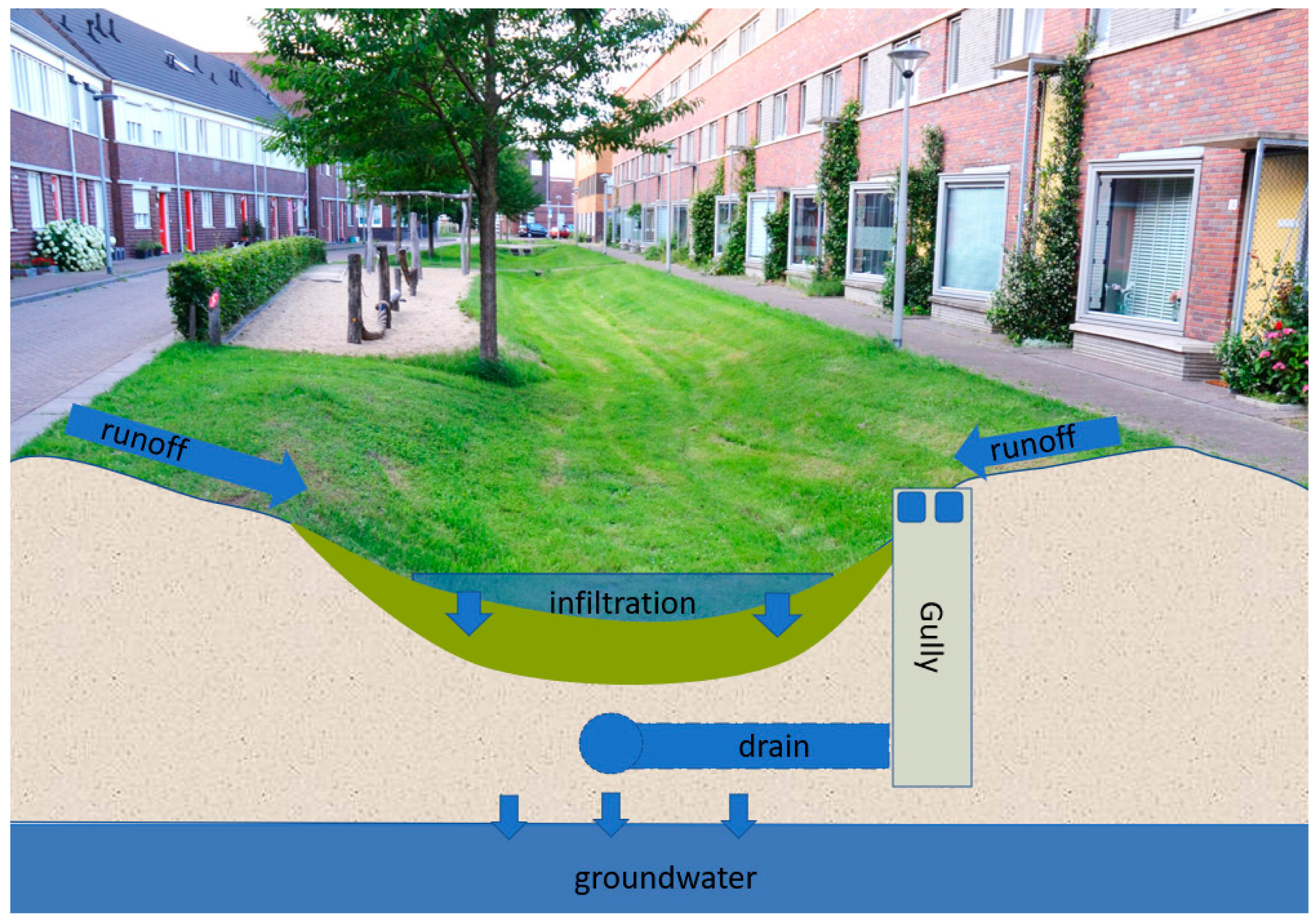
Figure 1. A typical Dutch bio-swale, the ‘standard conveyance swales’ also called a ‘dry swale’.
Sustainability 16 02618 g001
Figure 2. Selected locations for field measurements of potential toxic elements, marked in blue circles. All bio-swales in the study are mapped in the online toolbox ClimateScan (https://www.climatescan.nl/map#filter-1-1, accessed on 16 March 2024).
Sustainability 16 02618 g002
Figure 3. Collecting field measurements along a profile with intervals of 1 metre, with measuring time of 60 s. The instrument is pressed against the surface, topsoil, and values of elements are directly shown on the display as well as stored in the instrument [35].
Sustainability 16 02618 g003
Figure 4. Increasing number of nature-based project mapped in climatescan.org since the launch in 2014. Around 50% of the registrations in the database are bio-infiltration.
Sustainability 16 02618 g004
Figure 5. Example of pXRF results for three bio-swales in the municipality of Enschede using a traffic light signalling function, related to threshold values for each element copper (Cu), zinc (Zn) and lead (Pb). Red colour means action needed with concentration above intervention value. Green values are concentrations below the national threshold values. Yellow colours show concentrations between the target and intervention values.
Sustainability 16 02618 g005
Figure 6. Concentrations of zinc (Zn) compared to national standards. The sub-figures (AT) correspond with the locations in Table 2.
Sustainability 16 02618 g006
Figure 7. Concentrations of lead (Pb) compared to national standards. The sub-figures (AT) correspond with the locations in Table 2.
Sustainability 16 02618 g007
Figure 8. Concentrations of copper (Cu) compared to national standards. The sub-figures (AT) correspond with the locations in Table 2.
Sustainability 16 02618 g008
Table 1. Dutch national guidelines for bio-swales [8].
Design ParameterUnitValue
Water depth m0.3–0.5
Width bottomm>0.5
Slope1:n1:3
Thickness of top layer (for filtration)m>0.3
Humus in top layer% 3–5
Infiltration capacity Kdm/day>0.5
Time to empty h<48
Vegetation-Grass with high vegetation cover
Table 2. Locations of bio-swales included in the pXRF study. Map of the locations is shown in Figure 2.
No.MunicipalityStreet Name/
Location
Year of NBSAreal UseClimateScan Link
with Exact Location, Accessed on 16 March 2024
1GroningenHoendiep2006Industry/urbanhttps://climatescan.nl/projects/1054/detail
2GroningenSnip2002Residentialhttps://www.climatescan.nl/projects/11/detail
3HarenVondellaan2013Residentialhttps://climatescan.nl/projects/201/detail
4DrachtenSmaragd-Residentialhttps://climatescan.nl/projects/2495/detail
5GrouBiensma-Industrialhttps://www.climatescan.nl/projects/2496/detail
6AssenHoutlaan2000Residentialhttps://climatescan.nl/projects/2478/detail
7AlmeloTer Kleef2002Residentialhttps://climatescan.nl/projects/941/detail
8AlmeloLieven de Keystraat2004Residentialhttps://climatescan.nl/projects/951/detail
9HeilooJan Boltenhof Egelshoek2000Residentialhttps://climatescan.nl/projects/135/detail
10PurmerendBloemfontein2004–2005Residentialhttps://www.climatescan.nl/projects/1/detail
PurmerendSpringfontein2004–2005Residentialhttps://www.climatescan.nl/projects/1/detail
PurmerendKransfontein2004–2005Residentialhttps://www.climatescan.nl/projects/1/detail
PurmerendOranjefontein2004–2005Residentialhttps://www.climatescan.nl/projects/1/detail
11LimmenZonnendauw1999Residentialhttps://climatescan.nl/projects/3/detail
12AmsterdamBernabeuhof2000–2002Residentialhttps://climatescan.nl/projects/113/detail
13AmsterdamDelle Alpihof2002Residentialhttps://climatescan.nl/projects/6869/detail
14ArnhemIntanterie straat-Residentialhttps://www.climatescan.nl/projects/4/detail
15ArnhemBeukenlaan-Residentialhttps://climatescan.nl/projects/2489/detail
16EnschedeOikos2000Residentialhttps://climatescan.nl/projects/210/detail
17EnschedeMastbos Green1998–1999Residentialhttps://www.climatescan.nl/projects/5420/detail
18EnschedeMastbos Red1998–1999Residentialhttps://www.climatescan.nl/projects/211/detail
19ZutphenDe Bosrand-Residentialhttps://climatescan.nl/projects/2498/detail
20ZutphenDe Boomgard-Residential areahttps://climatescan.nl/projects/2499/detail
Table 3. Dutch threshold values for pollutants lead (Pb), zinc (Zn) and copper (Cu) in soil [35].
PT ElementsTarget Value ppm (mg/kg)Intervention Value ppm (mg/kg)
Lead (Pb)85530
Zinc (Zn)140720
Copper (Cu)36190
Table 4. Concentrations of pollutants in stormwater runoff from Dutch residential areas roofs and roads.
ParameterThe Netherlands (Rural) Stormwater Quality RIVM: 2012–2018The Netherlands (Stormwater Database)USA
NSQD
Overall
USA NSQD
Residential
Germany ATV Database
Literature[31][31][37][37][38]
Average
(D10–D90) *
Average
(D10–D90) *
Median
n = number
Median
n = number
Median
Copper (Cu) [μg/L]
MAC = maximum allowed concentration available (dissolved concentration)
Average 2.1
50–90%
1.1–4.5
N = 603
Average 28
50–90%
18–60
N = 183
16
n = 2724
12
n = 799
48
Lead (Pb) [μg/L]
MAC = 14
Average 0.93
50–90%
0.6–1.9
N = 619
Average 12
50–90%
4.6–32
N = 183
17
n = 2950
12
n = 788
118
Zinc (Zn) [μg/L]
MAC = 15.6
Average 8.2
50–90%
4.8–17
N = 617
Average 183
50–90%
74–256
N = 183
117
n = 3008
73
n = 810
275
TSS [mg/L] Average 56
50–90%
20–181
N = 114
58
n = 3390
49
n = 991
141
* The statistical parameters D10 and D90 are percentile values which indicate concentrations below 10 or 90% of all concentrations.
Table 5. An overview of the relation between adjacent buildings and infrastructure and pollutant concentrations using pXRF compared to the national standards.
LocationBuilding Age (Majority of Adjacent Buildings)Usage of BuildingsRoof TypeAdjacent Road TypeOther Relevant AdjacenciesTotal Number of
Measurements (xrf)
Zn > 140 ppm Zn > 720 ppm
(Highest ppm)
Cu > 36 ppmCu > 190 ppm
(Highest ppm)
Pb > 85 ppmPb > 530 ppm
Lieven de Keystraat1959HousingTilesBrickParking next to measurement1022 (742)1010
Ter Kleef1975HousingFlat roof, bitumen, gritBrickGardens on boundary of measurement15004000
Delle Alpihof2002HousingFlat roofs with bitumen and GritPavingN.A.3000000
Bernabeuhof2002HousingFlat roof, bitumen, gritPavingN.A.3000000
Beukenlaan1935–1952Housing, sport facility, greenhouseTiles, flat roofs, bitumenBrickParking next to measurement4000000
Infanteriestraat1939–2016Mixed used, housing, officesTilesBrickParking next to measurement14200010
Houtlaan2001–2004HousingTilesBrickN.A.8000000
Smaragd2005–2006HousingFlat roof, corrugated metal, bitumenBrickN.A.13000000
Mastbos Red1997HousingTilesBrickGardens on boundary of measurement8000000
Mastbos Green1998HousingTilesBrickGardens on boundary of measurement1940101 (197)10
Oikos2005HousingTilesBrickN.A.831 (742)0000
Hoendiep1970–1991IndustryFlat roof, bitumenAsphaltNext to a main road19201000
SnipN.A.Garden houses and shedsTiles and flat roofs with bitumenDirtGardens on boundary of measurement10000000
Bolsward2001–2003IndustryFlat roofs with bitumenAsphaltNext to a main road11000000
Vondellaan1969–1968HousingFlat roofs with bitumen and gritAsphaltNext to a main road2152 (977)2010
Jan Boltenhof Egelshoek2000HousingFlat roofs with bitumen and gritBrickParking next to measurement61000000
Zonnedauw2001HousingTilesBrickN.A.45000000
Bloemfontein2005HousingTilesBrickParking next to measurement6300000
Springfontein2005HousingTilesBrickParking next to measurement6500020
Oranjefontein2005HousingTilesBrickParking next to measurement3200000
Kransfontein2005HousingTilesBrickParking next to measurement4300000
De Varentuin1999HousingTilesBrickParking next to measurement12204000
De Bosrand1999HousingBitumen and gritBrickParking next to measurement19512000
Disclaimer/Publisher’s Note: The statements, opinions and data contained in all publications are solely those of the individual author(s) and contributor(s) and not of MDPI and/or the editor(s). MDPI and/or the editor(s) disclaim responsibility for any injury to people or property resulting from any ideas, methods, instructions or products referred to in the content.