
Geoheritage and Geoconservation, from Theory to Practice: The Ghost Town of Craco (Matera District, Basilicata Region, Southern Italy)

 ,
,  ,
,  ,
,  ,
,  and
and 
Abstract
1. Introduction
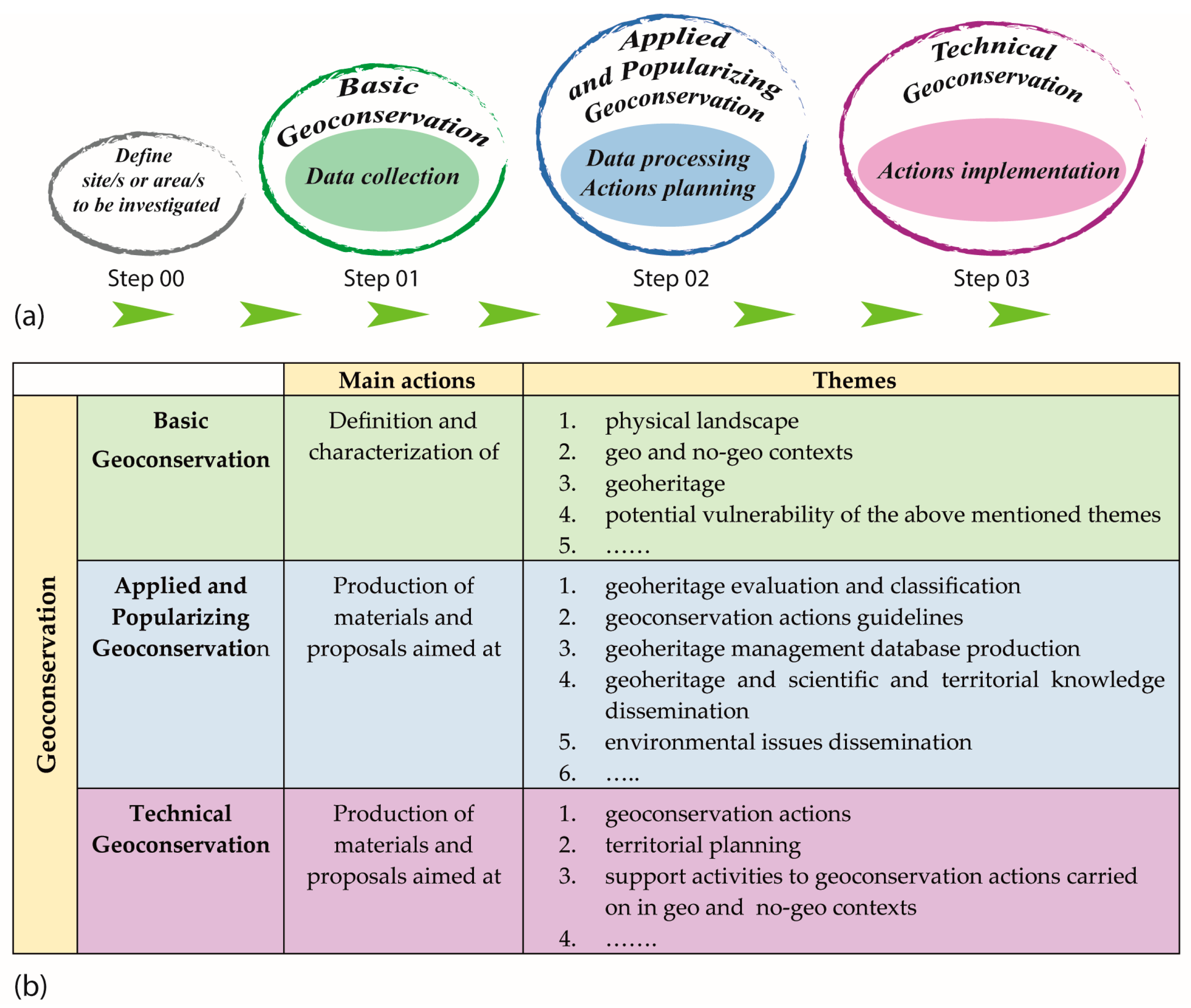
2. Materials and Methods
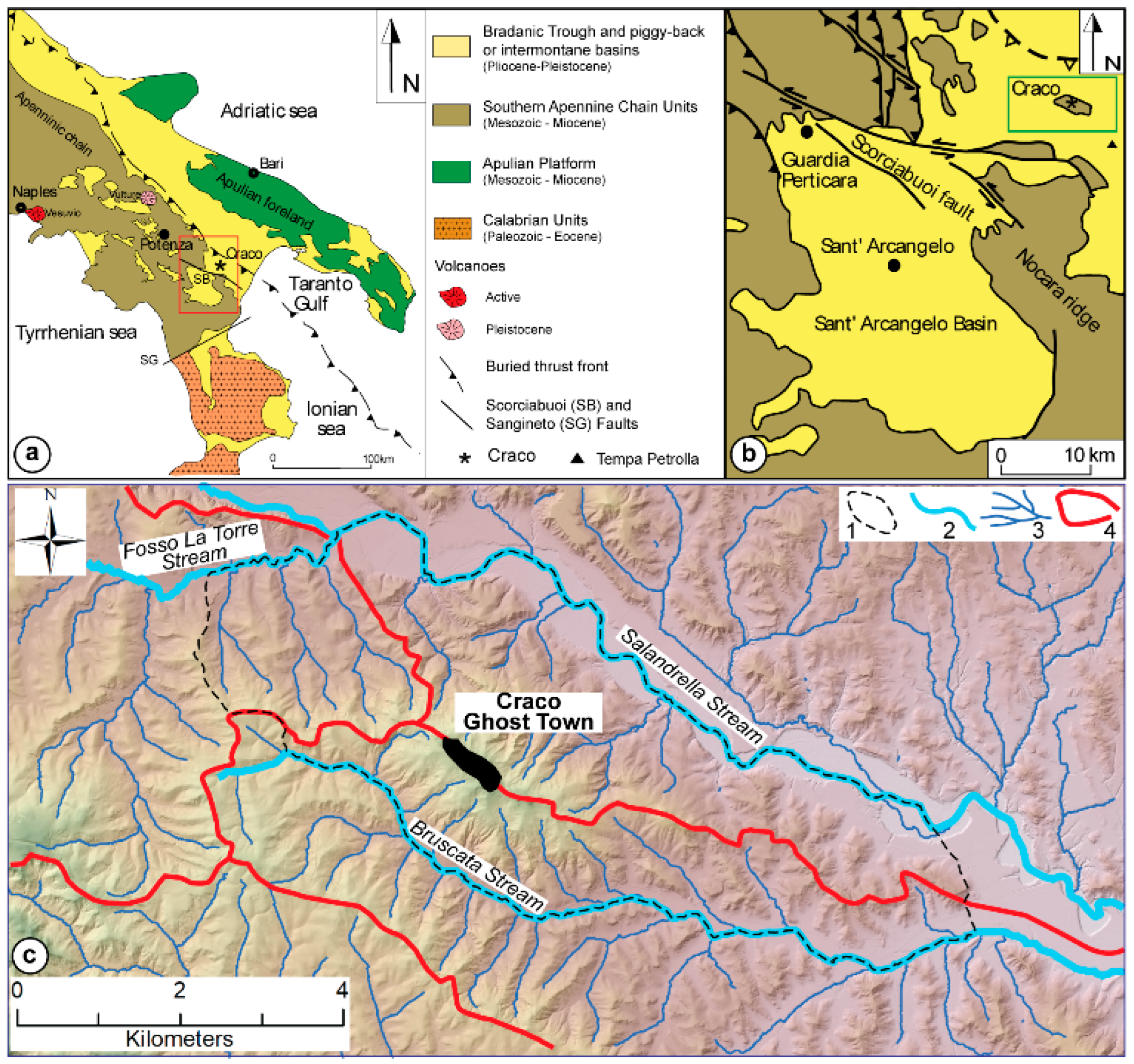
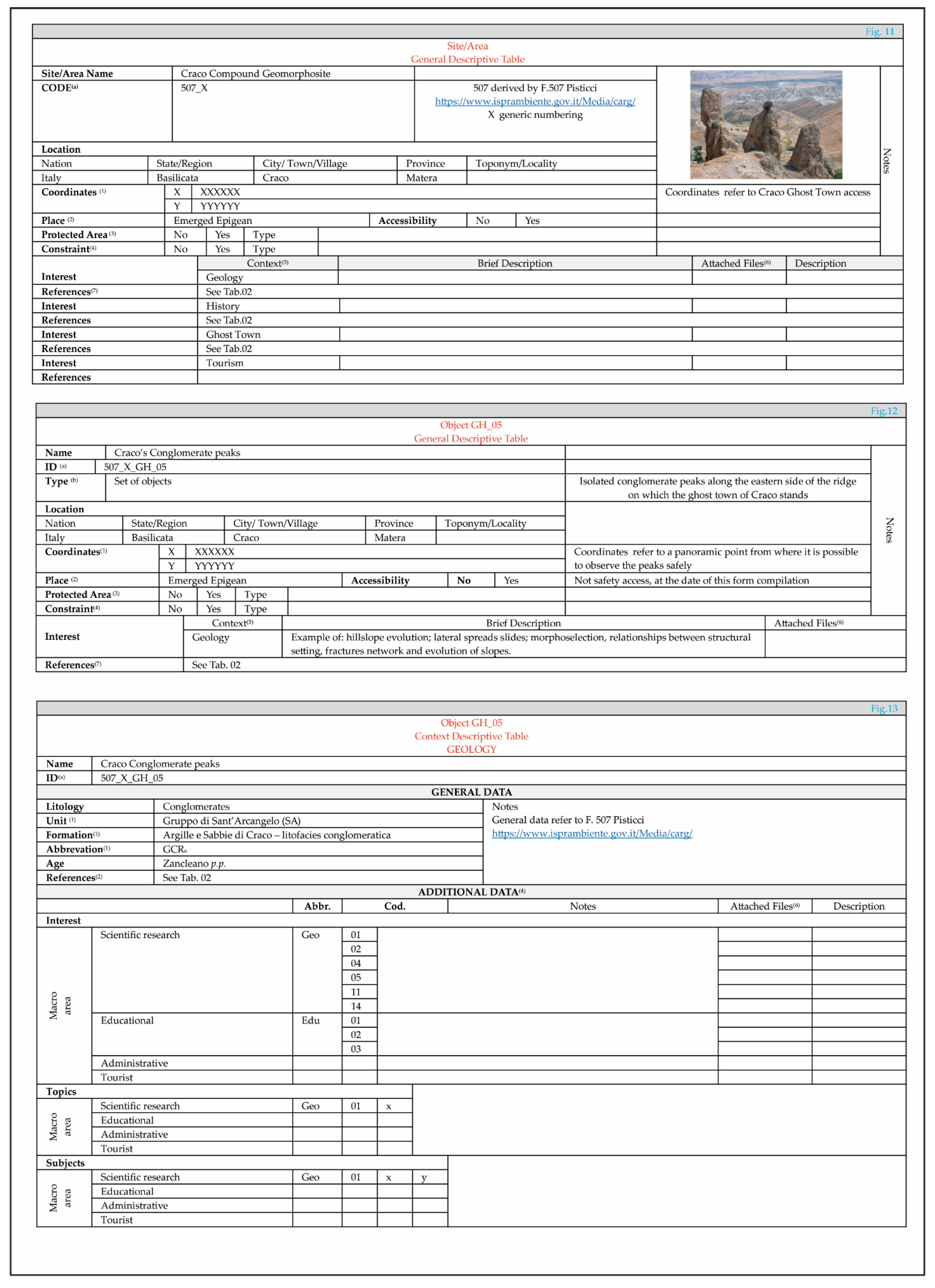
3. Step 00 Area Description and Choice Reasons
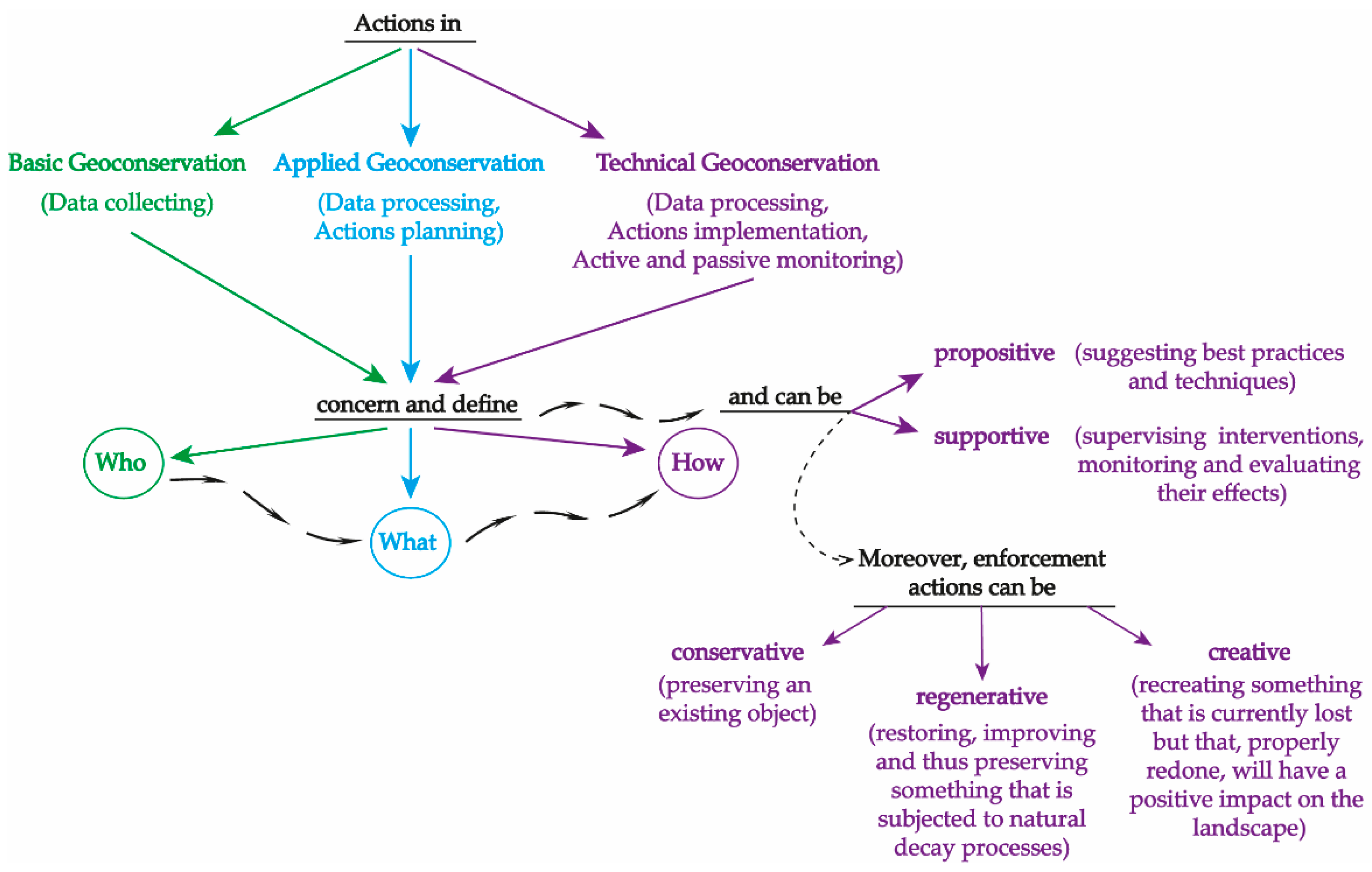
4. Step 01 Basic Geoconservation
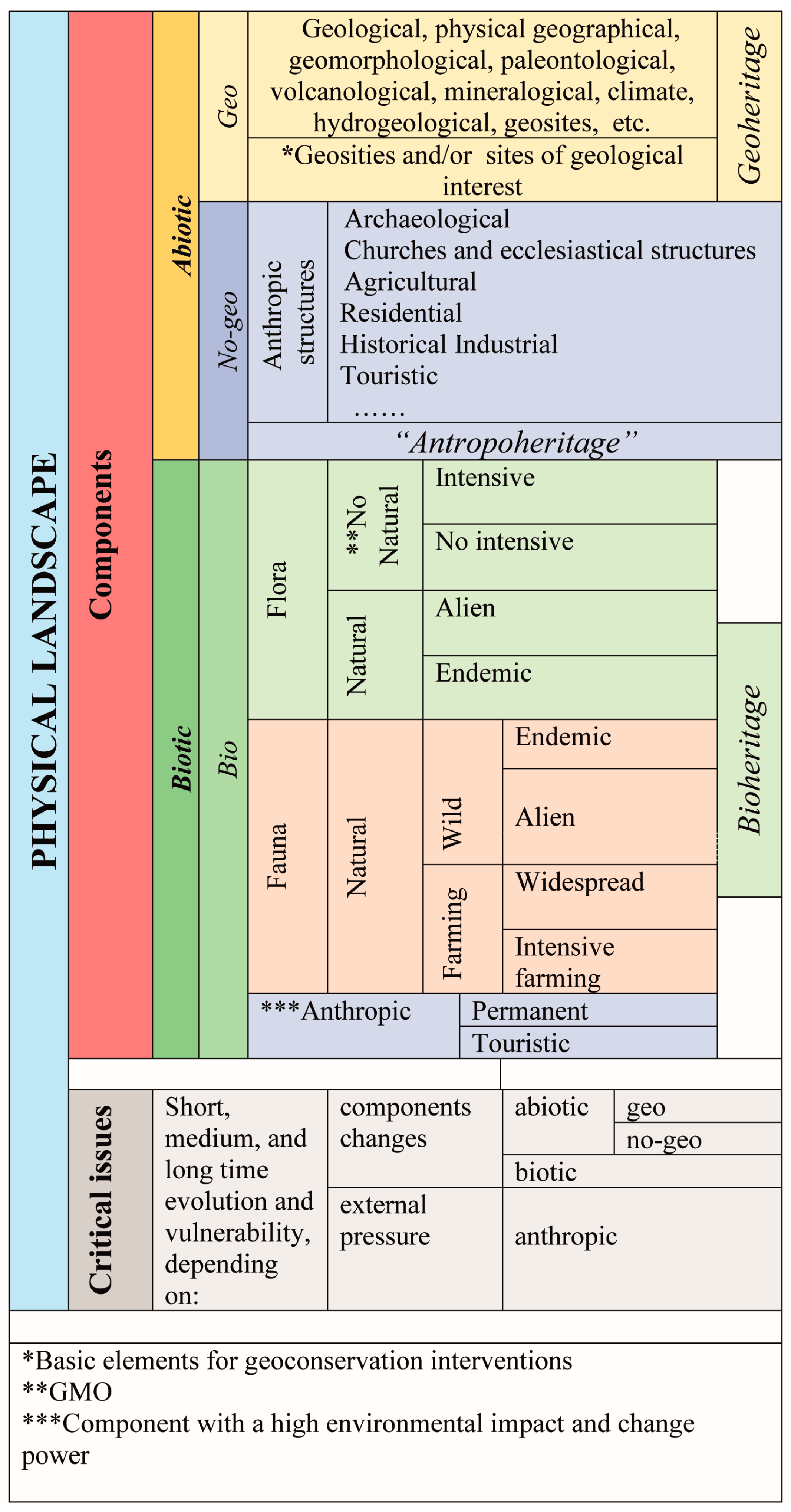
4.1. Physical Landscape: Abiotic Components
4.1.1. Geo Context
- Available bibliography
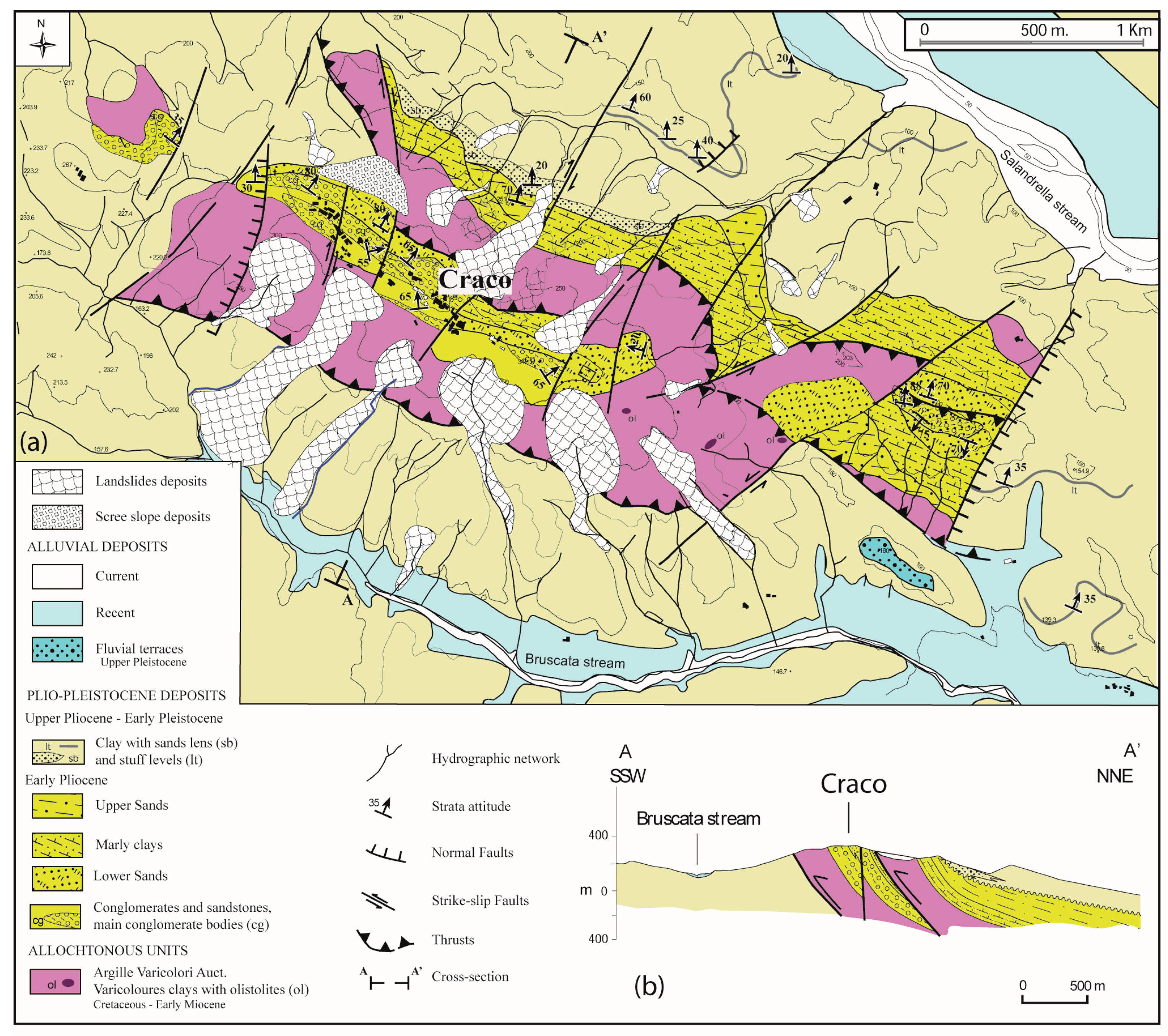
- Geology
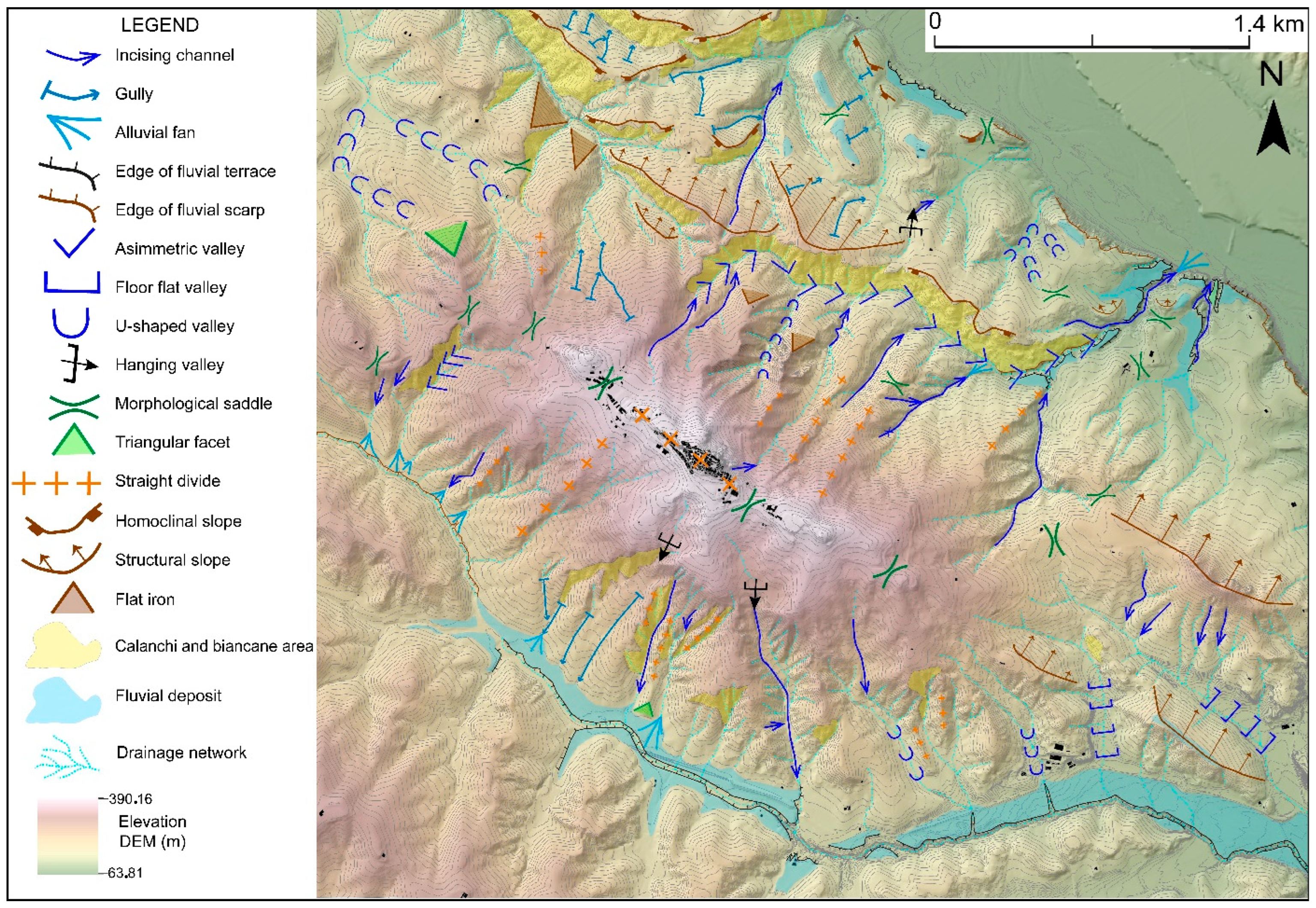
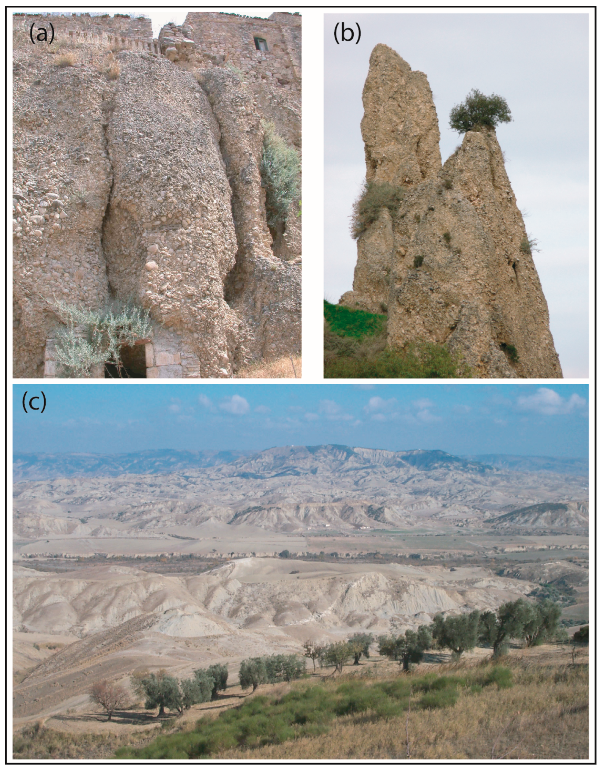
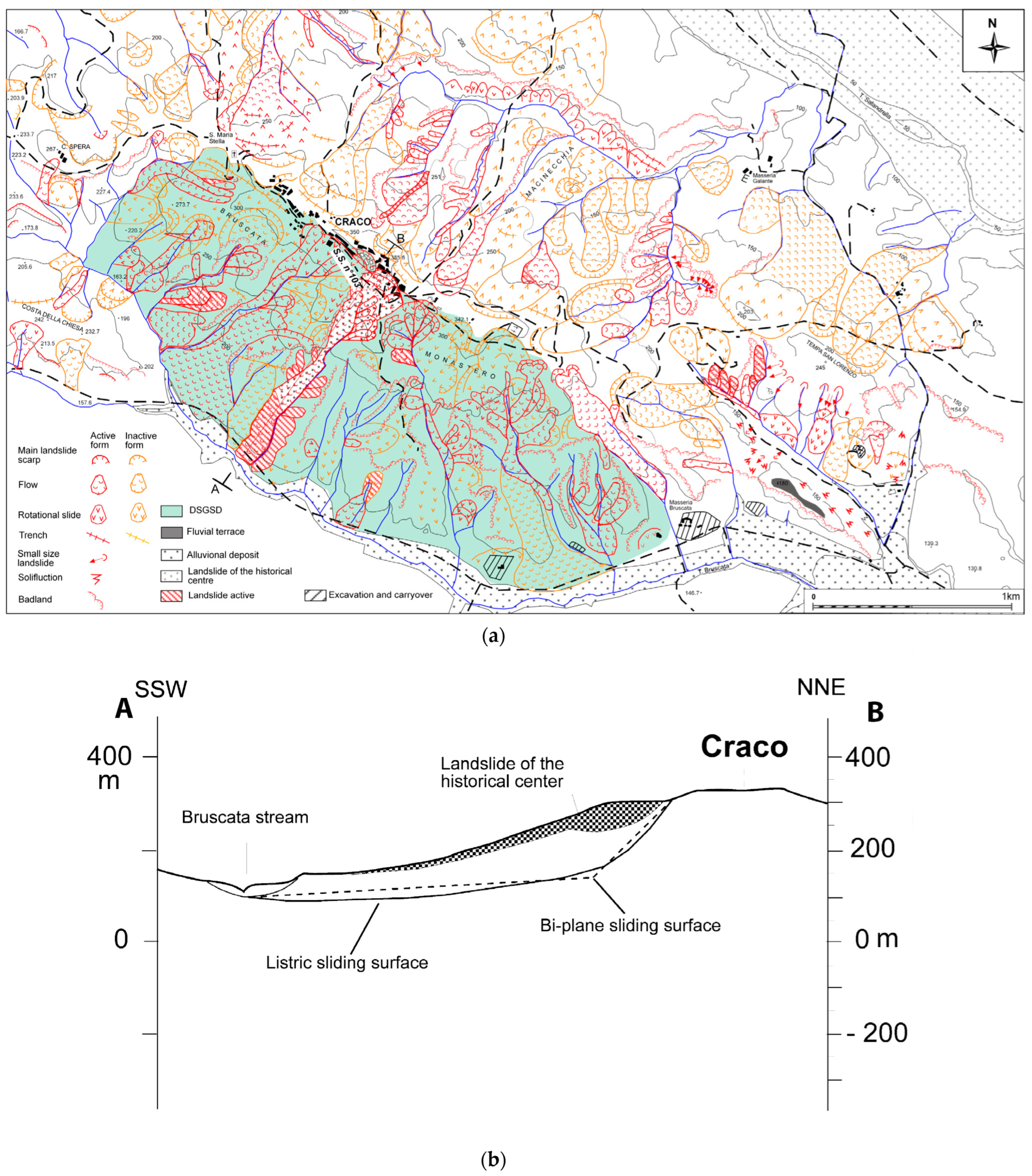
- Geomorphology and slope evolution
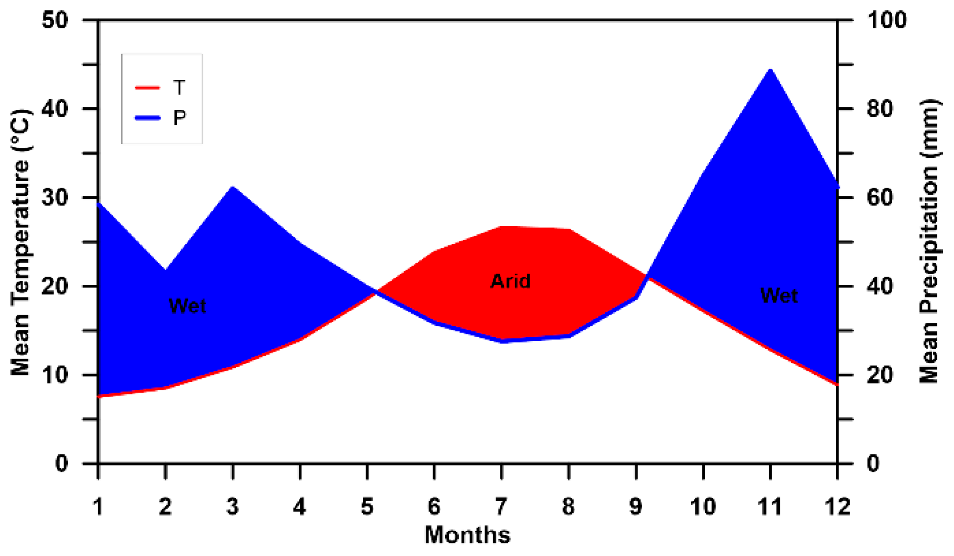
- Climate
- Geosites
4.1.2. No-Geo Context
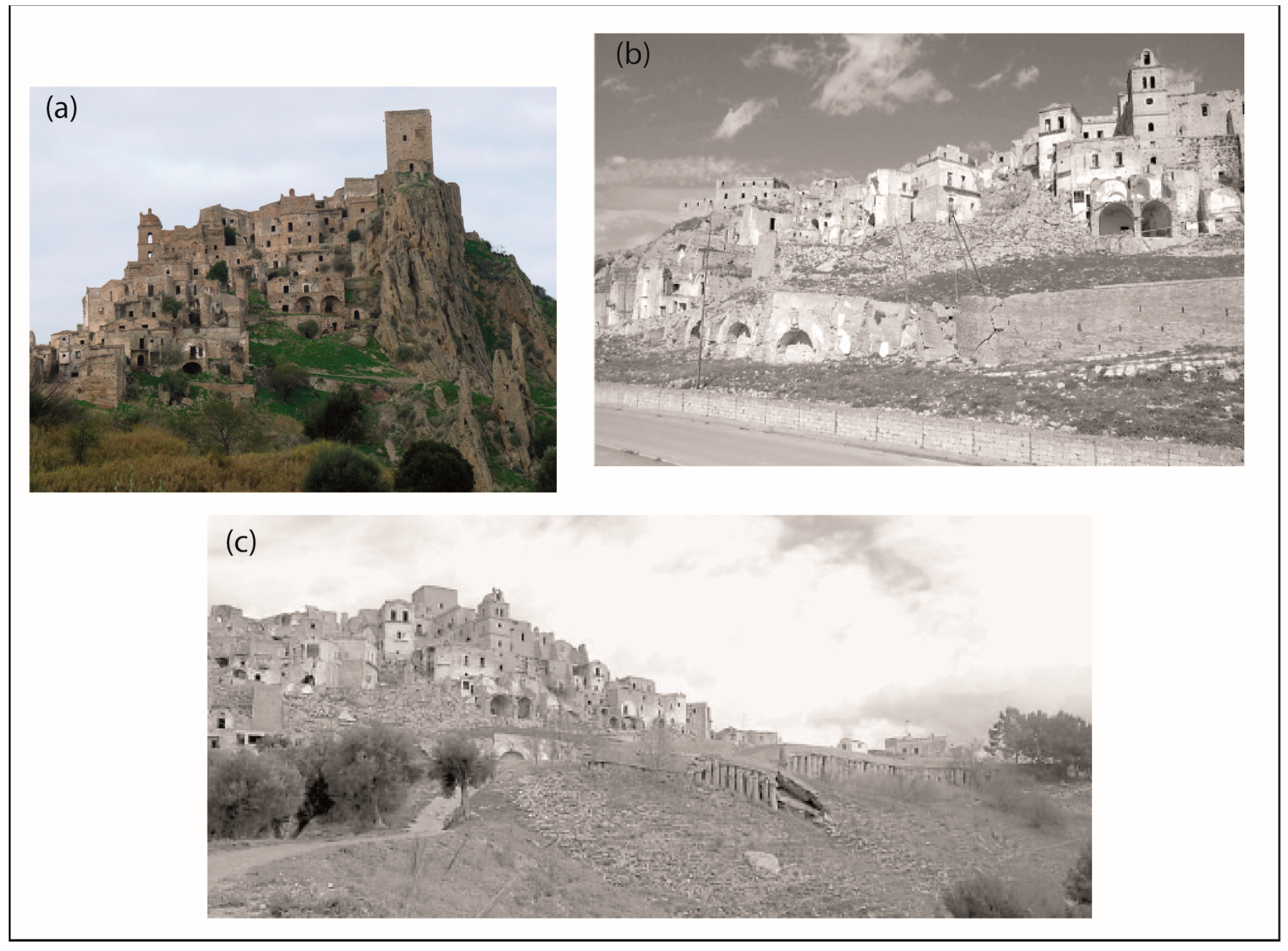
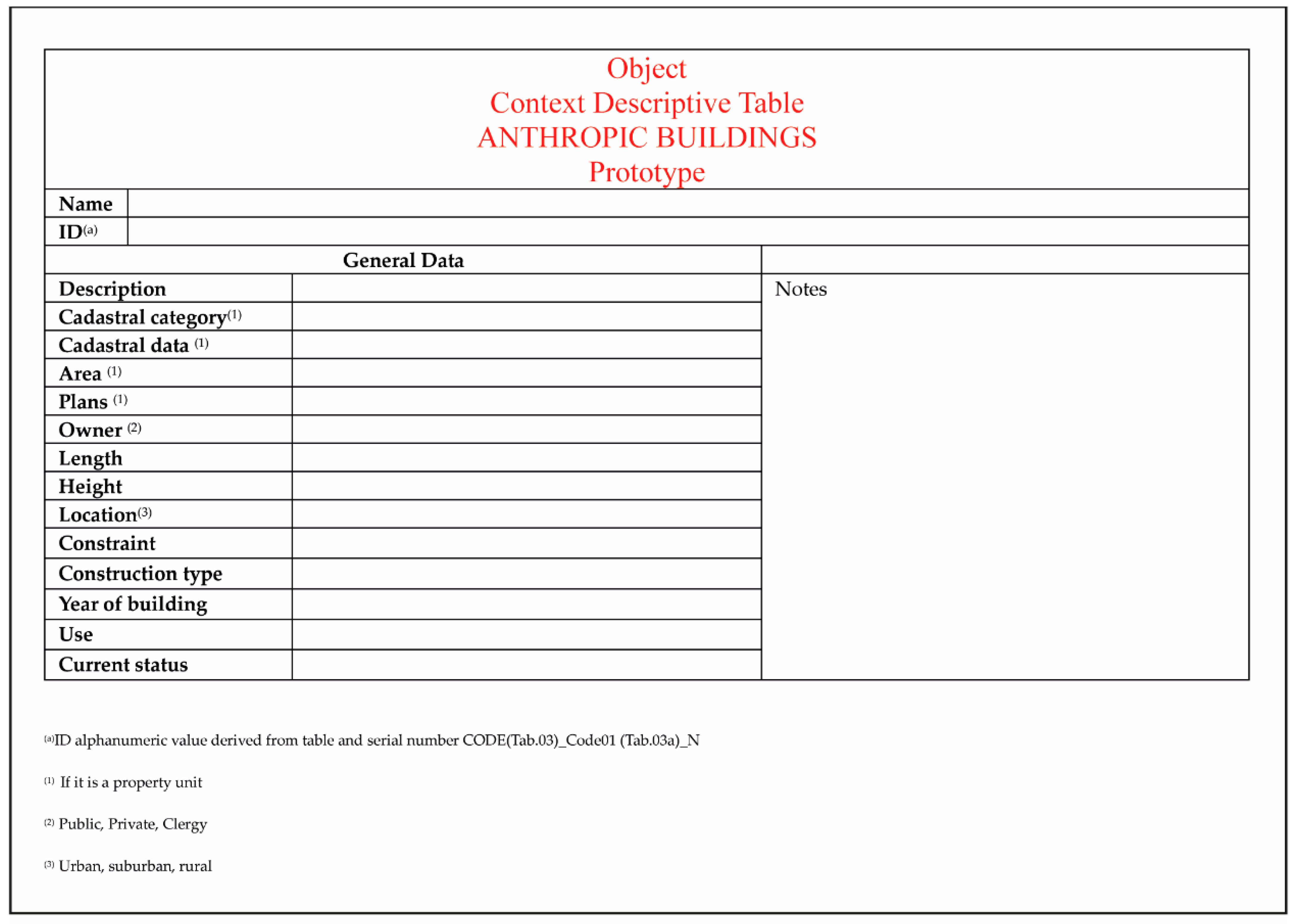
- Anthropic structures
4.2. Physical Landscape: Biotic Components
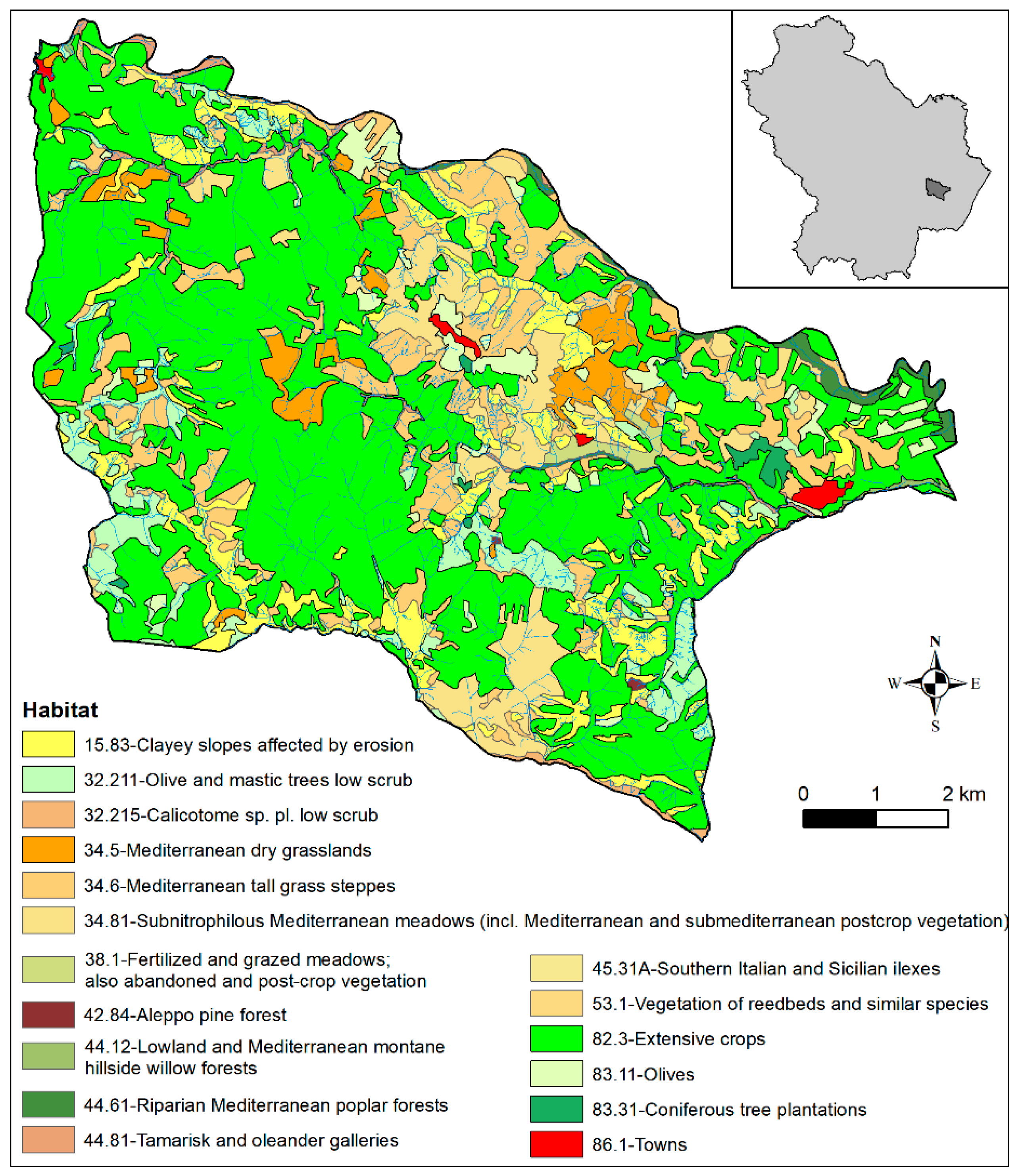
- Habitat
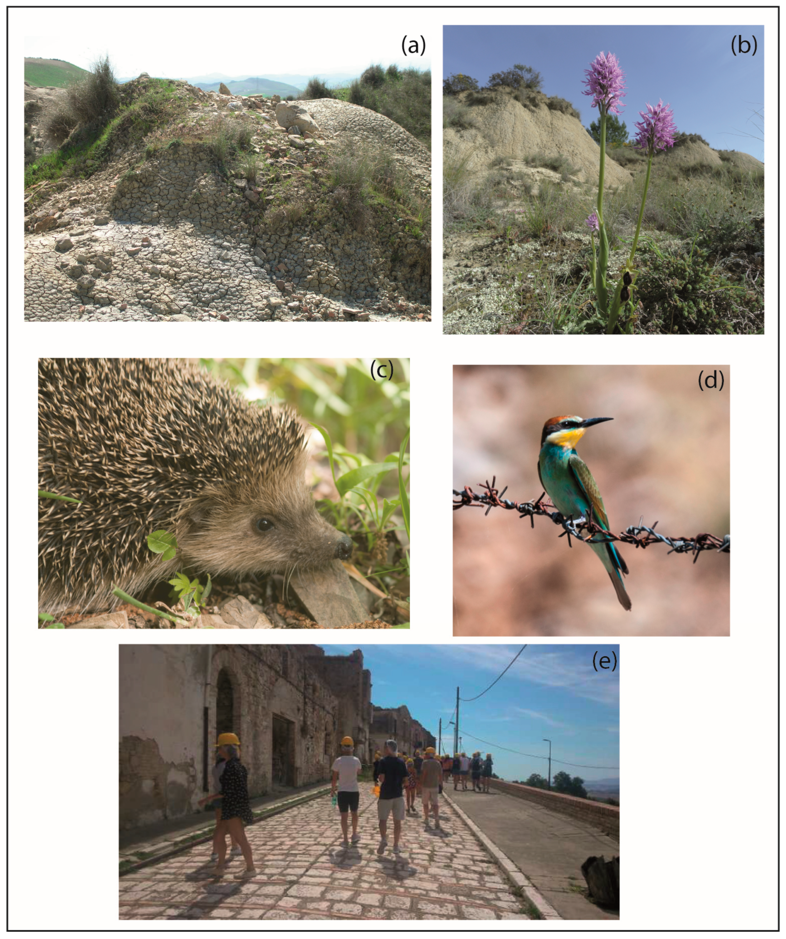
- Flora
- Fauna
- Anthropic
4.3. Physical Landscape: Critical Issues
- Natural critical issues
- Human-induced critical issues
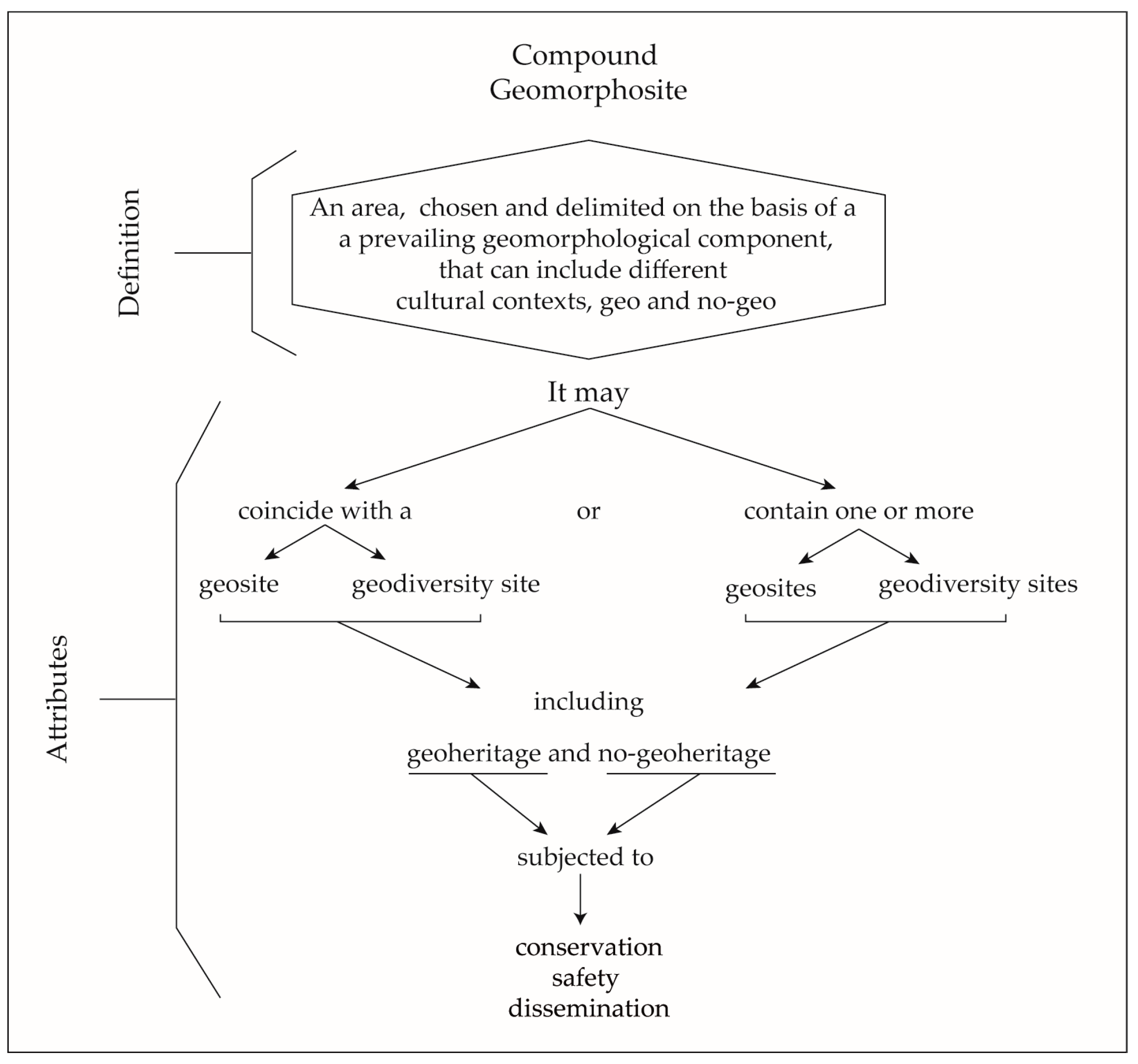
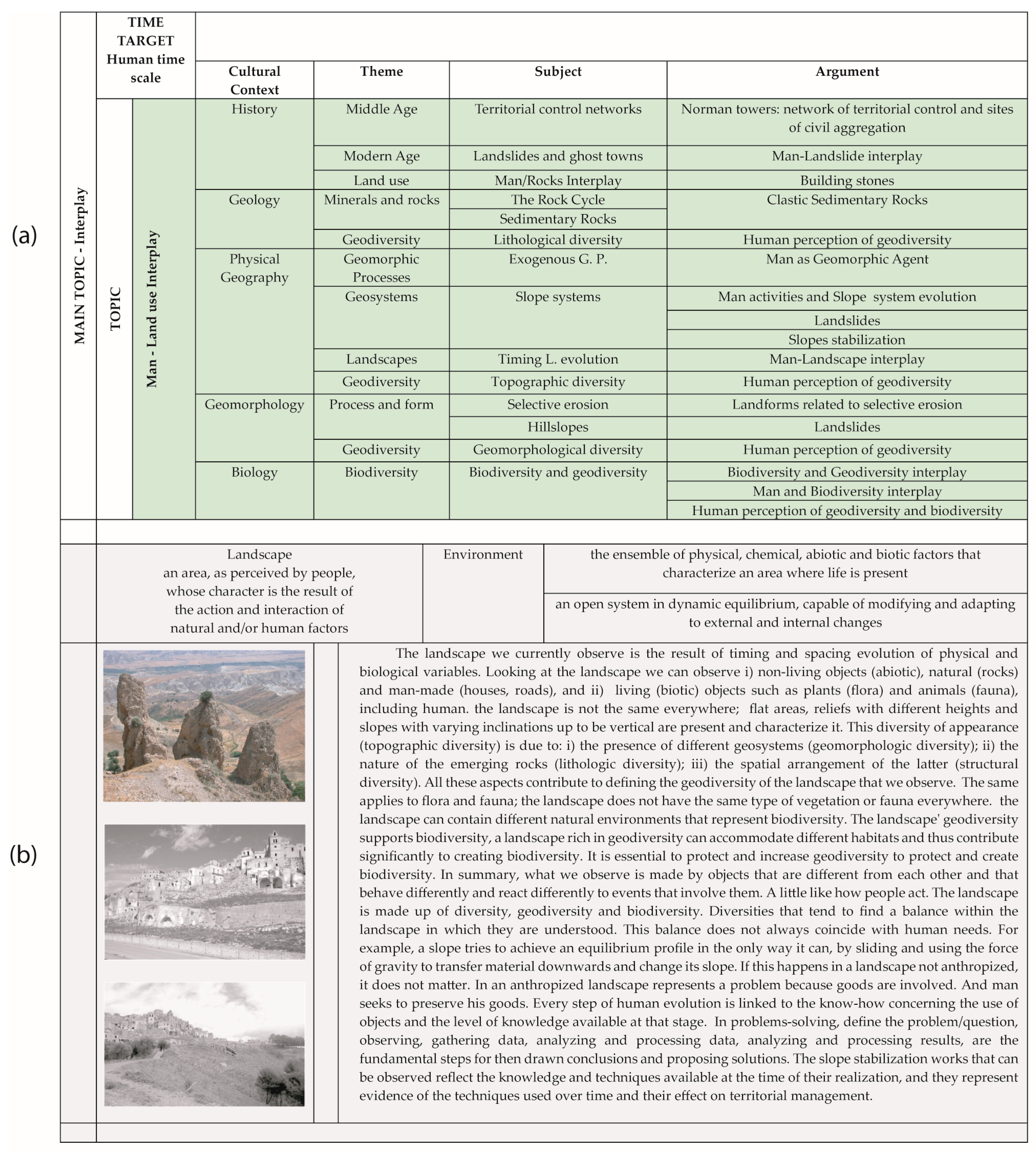
5. Step 02 Applied and Popularizing Geoconservation
5.1. Scientific Research Macro-Area
- Available references
- Geology and Geomorphology
- Geoheritage and AnthropoGeoheritage.
- Geoconservation actions
5.2. Administrative Macro-Area
- Geoconservation actions
5.3. Educational Macro-Area
- Geoconservation actions
5.4. Tourist Macro-Area
- Geoconservation actions
6. Step 03 Technical Geoconservation
7. Discussion and Conclusions
Author Contributions
Funding
Institutional Review Board Statement
Informed Consent Statement
Data Availability Statement
Conflicts of Interest
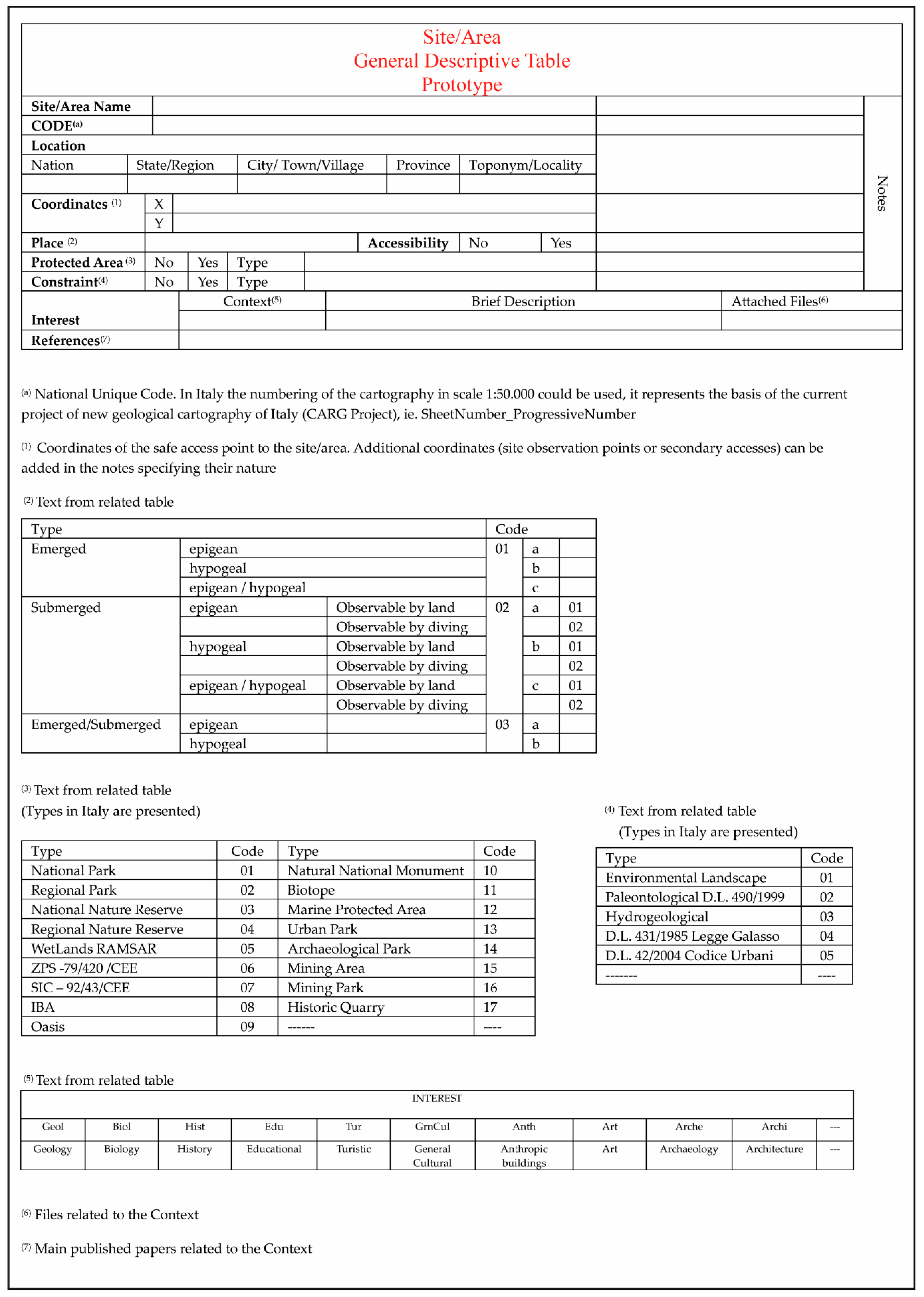
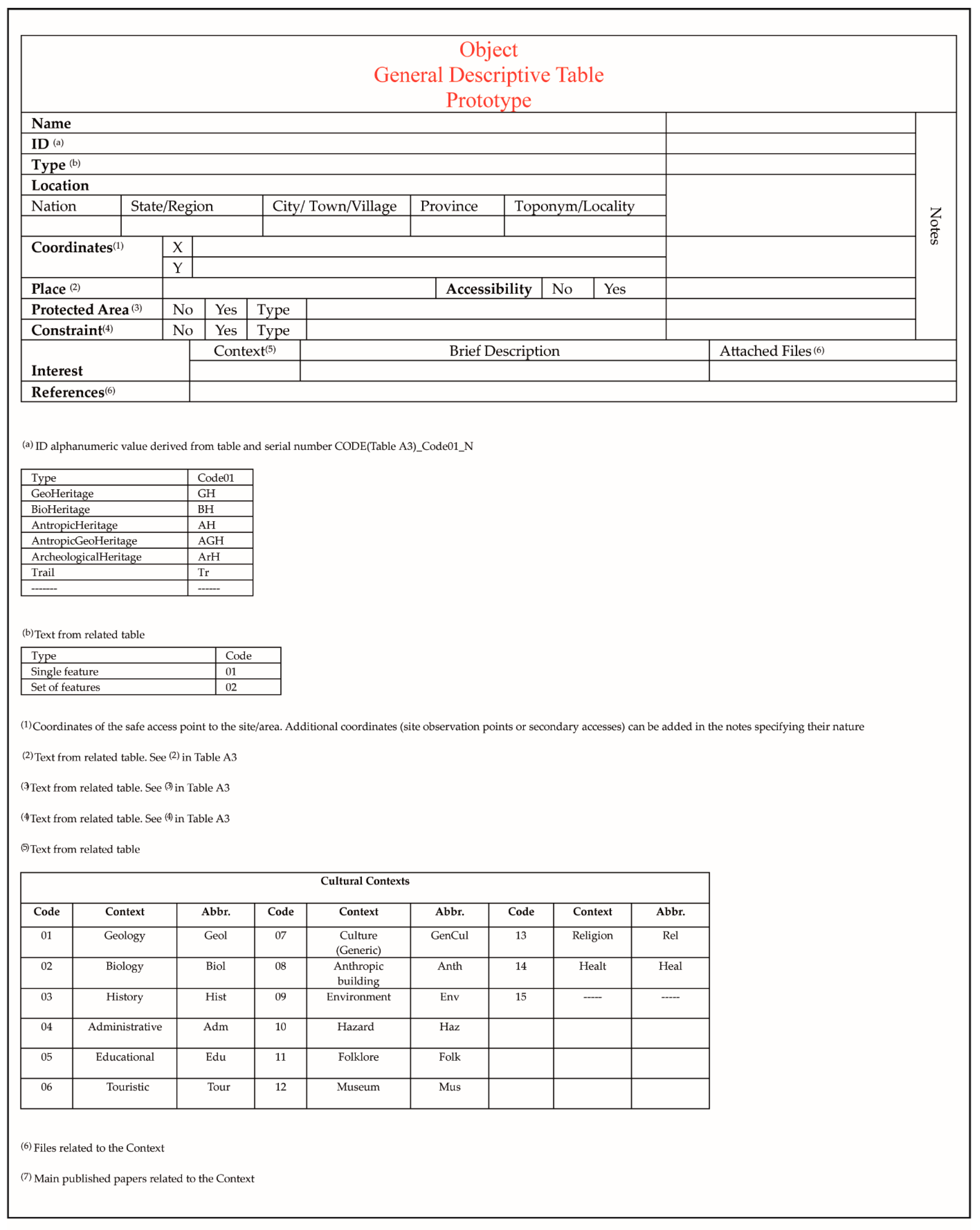
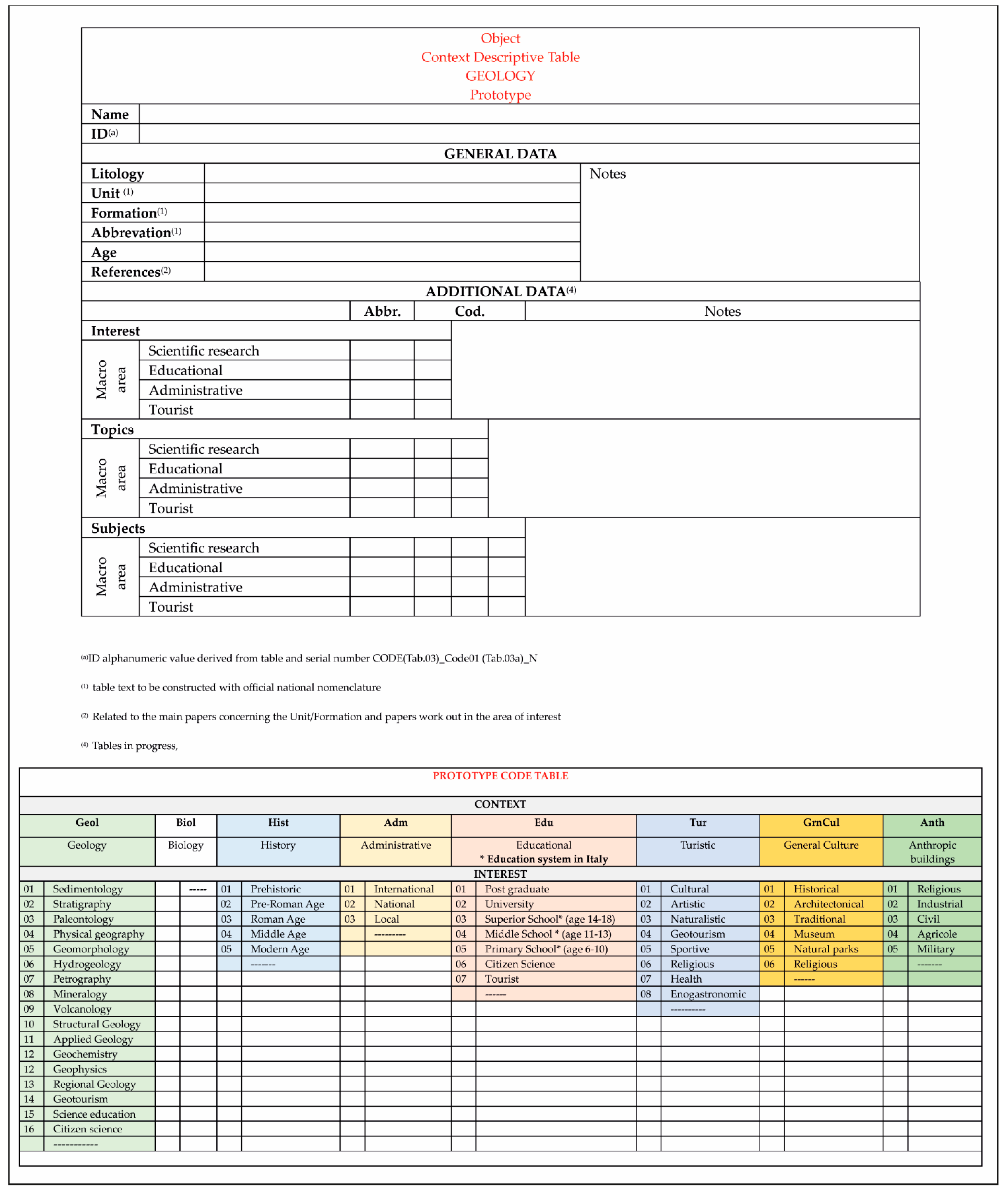
Appendix A

| Cultural Contexts | ||||||||
|---|---|---|---|---|---|---|---|---|
| Code | Context | Acronym | Code | Context | Acronym | Code | Context | Acronym |
| 01 | Geology | Geol | 07 | Culture (Generic) | GenCul | 13 | Religion | Rel |
| 02 | Biology | Biol | 08 | Anthropic building | Anth | 14 | Health | Heal |
| 03 | History | Hist | 09 | Environment | Env | 15 | ----- | ----- |
| 04 | Administrative | Adm | 10 | Hazard | Haz | |||
| 05 | Educational | Edu | 11 | Folklore | Folk | |||
| 06 | Touristic | Tur | 12 | Museum | Mus | |||
| 1 | Cotecchia V. (1959) Il dissesto idrogeologico nella Provincia di Matera. Annali della Facoltà di Ingegneria (Bari) 3:363–388. |
| 2 | Brugner W. (1964)—Sulle condizioni di stabilità dell’abitato di Craco (Provincia di Matera). Servizio Geologico d’Italia, Largo S. Susanna, 13, Roma |
| 3 | Servizio Geologico d’Italia (1968)—Carta Geologica d’Italia F. 200 Tricarico della carta 1:100.000 dell’ IGM, Poligrafica & Cartevalori Ercolano (Napoli), avaiable on line at < http://sgi.isprambiente.it/geologia100k/mostra_foglio.aspx?numero_foglio=200> |
| 4 | Servizio Geologico d’Italia (1969)—Carta Geologica d’Italia F. 201 Matera della carta 1:100.000 dell’ IGM, Litografia Artistica Cartogafica Firenze, avaiable on line at < http://sgi.isprambiente.it/geologia100k/mostra_foglio.aspx?numero_foglio=201> |
| 5 | Ogniben L. (1969)—Schema introduttivo della geologia del confine calabro-lucano, Mem. Soc. Geol. It, 8, 453–763 |
| 6 | Lentini, F. (1969). Facies e stratigrafia dei depositi pliocenici affioranti fra il F. Agri e la zona di Craco.(Matera). Atti Acc. Gioenia Sc. Nat. Catania, s. 7(1), 529–556. |
| 7 | Lentini F. (1971)—La sezione plio-pleistocenica di Pisticci sul bordo appenninico della Fossa Bradanica. Atti Acc. Gioenia Sc. Nat. Catania, s.7, 3: 109–192. |
| 8 | Boenzi F., Palmentola G. & Valduca A. (1971)—Note Illustrative della Carta Geologica d’Italia alla Scala 1:100.000 Foglio 200 Tricarico, Nuova Tecnica Grafica Roma, avaiable on line at<http://sgi.isprambiente.it/geologia100k/mostra_pdf.aspx?pdffile=200.pdf> |
| 9 | Boenzi F., Radina B., Ricchetti G. & Valduga A. (1971)—Note Illustrative della Carta Geologica d’Italia alla Scala 1:100.000 Foglio 201 Matera, Nuova Tecnica Grafica Roma, avaiable on line at < http://sgi.isprambiente.it/geologia100k/mostra_pdf.aspx?pdffile=201.pdf> |
| 10 | Pellegrino M (1972) Descrizione della frana di Craco in Lucania. Il frantoio, pp 34–41 |
| 11 | Pellegrino M, Priore E (1973) Descrizione di alcuni dissesti verificatisi in Lucania durante le recenti precipitazioni. Il frantoio XI 6:10–14 |
| 12 | Del Prete M, Petley DJ (1982) Case history of the main landslide at Craco, Basilicata, South Italy. Geol Appl Idrogeol 17:291–304 |
| 13 | Del Prete M (1990) La difesa dei Centri Storici minacciati dalle frane: Craco un’esperienza da non ripetere. Sc Dir. Econ. Amb. 7–8:39–41 |
| 14 | Pedio T (1990) Centri scomparsi in Basilicata. Osanna Edizioni, Venosa |
| 15 | Lazzari S. & Lentini F. (1991)—Carta Geologica del Bacino del Fiume Agri. Scala 1:50.000, S.EL.CA. (Ed.),Firenze. |
| 16 | Pieri P., Sabato L., Loiacono F. & Marino M. (1994)—Il bacino di piggyback di Sant’Arcangelo: evoluzione tettonico-sedimentaria. Boll. Soc. Geol. It., 113: 465–481. |
| 17 | Rescio P. F., 1998, Storia e architettura di Craco, in Basilicata Regione Notizie, XI/3, 93–96. |
| 18 | Bentivenga M, Coltorti M, Prosser G (2004) Il movimento gravitativo profondo di Craco (Basilicata Ionica). Il Quaternario, Italian Journal of Quaternary Sciences 17(2/2):613–625 |
| 19 | Del Monaco G, Falconi L, Margottini C, Puglisi C, Spizzichino D (2004) Integrated approach for landslide risk assessment of Craco village (Italy). In: (a cura di): Lacerda, Ehrlich, Fontoura, Sayao, Landslides: evaluation andstabilisation. Taylor & Francis, London ISBN: 9780415356657 |
| 20 | Bentivenga M, Foresi LM, Prestera A, Prosser G, Sabia M (2005) Structures located at the front of a thrust and fold belt: the Craco area (Southern Apennines, Italy). Boll Soc Geol Ital 124(2):367–376 |
| 21 | Delmonaco, G., Falconi, L., Leoni, G., Margottini, C., Puglisi, C., & Spizzichino, D. (2005). Multi-temporal and quantitative geomorphological analysis on the large landslide of Craco Village. In K. Sassa, H. ter management (vol. 2. pp. 113–117). Berlin Heidelberg: Springer-Verlag. ISBN/ISSN: 978-3-540-28664-6, 10.1007/3-540-28680-2_13. |
| 22 | Masini N. (2006). Dai Normanni agli Angioini: castelli e fortificazioni della Basilicata. In: Storia della Basilicata. Il Medioevo, a cura di Fonseca C. D., 689–753, Editori Laterza |
| 23 | Prosser, G., Bentivenga, M., Laurenzi, M., Caggianelli, A., Dellino, P., & Doronzo, D. (2008). Late Pliocene volcaniclastic products from Southern Apennines: Distal witness of early explosive volcanism in the central Tyrrhenian Sea. Geological Magazine, 145(4), 521–536. doi:10.1017/S0016756808004512 |
| 24 | Papallo O., Bianco P.M., 2012. Carta della Natura della Regione Basilicata: Carta degli habitat alla scala 1:50.000. ISPRA, <https://www.isprambiente.gov.it/it/servizi/sistema-carta-della-natura/cartografia/carta-della-natura-alla-scala-1-50.000/basilicata> |
| 25 | Angelucci F, Domenici F, Ricci S (2013) Prime acquisizioni sull’abitato e la torre normanna di Craco (Matera). In E. De Minicis (a cura di) Case e torri medievali IV—Indagini sui centri dell’Italia Meridionale e insulare (sec. XI-XV) Campania, Basilicata, Puglia, Calabria, Sicilia e Sardegna. Atti del V Convegno Nazionale di Studi (Orte, 15–16 Marzo 2013), 81–106 |
| 26 | ISPRA (2014)—Progetto CARG Nuova Cartografia Geologica alla scala 1:50.000 F 507 Pisticci https://www.isprambiente.gov.it/Media/carg/507_PISTICCI/Foglio.html |
| 27 | De Cadilhac, R. (2014) The Norman tower in the abandoned village of Craco (MT). Meaning and reasons of the restoration. Key Engineering Materials, Volume 628, Pages 34—392014 International Conference on Historical Centres among Culture, Art and Techniques: A New Paradigma for Risks Prevention Through Structural Monitoring, SMART BUILT 201427 March 2014through 29 March 2014Code 107497. DOI: 10.4028/www.scientific.net/KEM.628.34. |
| 28 | ISPRA (2015)—Progetto CARG Nuova Cartografia Geologica alla scala 1:50.000 Note Illustrative del F 507 Pisticci, a cura di Carbone S., Lentini F., https://www.isprambiente.gov.it/Media/carg/note_illustrative/507_Pisticci.pdf |
| 29 | Bentivenga, M., Capolongo, D., Palladino, G., & Piccarreta, M. (2015). Geomorphological map of the area between Craco and Pisticci (Basilicata, Italy). Journal of Maps, 11 (2), 267–277. doi:10.1080/17445647.2014,935501 |
| 30 | Pirlone F (2016) I borghi antichi abbandonati. Patrimonio da riscoprire e mettere in sicurezza. Franco Angeli Editore, Milan ISBN 9788891740588 |
| 31 | Doronzo, D.M., Caggianelli, A. & Dellino, P. A ghost eruption behind “Le vulcanoclastiti di Craco” ghost town, Basilicata, Italy. Int J Earth Sci (Geol Rundsch) 108, 545–546 (2019). https://doi.org/10.1007/s00531-018-1665-z |
| 32 | Gizzi F.T., Bentivenga M., Lasaponara R., Danese M., Potenza M.R., Sileo M. & Masini N. (2019)—Natural Hazards, Human Factors, and “Ghost Towns”: a Multi-Level Approach, Geoheritage, 11, 1533–1565. |
| 33 | Lerna, M., Sabbà, M. F. Diaferio, M.; Carnimeo, L., Ivorra, S.; Foti, D. (2020) Seismic risk assessment of a medieval tower: The case study of Craco Proceedings of the International Conference on Structural Dynamic, EURODYNVolume 2, Pages 4911—4921202011th International Conference on Structural Dynamics, EURODYN 2020Virtual, Athens 23 November 2020through 26 November 2020Code 165382 |
| 34 | D’Agostino, A.; Cerreta, M.; Vannelli, G.; Zizzania, P. (2020) A way for the italian inner area montagna materana rethink the abandonment from craco. Sustainable Mediterranean Construction, Volume 2020, Issue 4 Special Issue, Pages 69—732020 |
| 35 | De Cadilhac, R., Catella, M.A. (2020) Craco, a medieval village. The re-invention of places throughout new forms of anthropization and museum display | Il borgo medievale di Craco: la reinvenzione dei luoghi tra nuove forme di antropizzazione e musealizzazione. ArcHistoR, 2020, 13(7), pp. 1243–1267 |
| 36 | De Cadilhac, R, Catella, M.A. (2022) Il borgo medievale di Craco: la “reinvenzione dei luoghi” tra nuove forme di antropizzazione e musealizzazione. ARCHISTOR-ARCHITECTURE HISTORY RESTORATION (13), pp. 1242–1267 |


| ID | KW01 | KW02 | KW03 | KW04 | KW05 |
|---|---|---|---|---|---|
| 1 | Geo | Applied Geology | Hydrogeological disturbance | ITA_S | L |
| 2 | Geo | Applied Geology | Hydrogeological disturbance | ITA_S | L |
| 3 | Geo | Geological map | Geological Map of Italy at 1:100.000 scale | ITA_S | R |
| 4 | Geo | Geological map | Geological Map of Italy at 1:100.000 scale | ITA_S | R |
| 5 | Geo | Regional geology | Stratigraphy | ITA_S | R |
| 6 | Geo | Stratigraphy | Pliocene deposits | ITA_S | R |
| 7 | Geo | Stratigraphy | Pliocene and Pleistocene deposits | ITA_S | R |
| 8 | Geo | Text related to Geological map | Geological Map of Italy at 1:100.000 scale | ITA_S | R |
| 9 | Geo | Text related to Geological map | Geological Map of Italy at 1:100.000 scale | ITA_S | R |
| 10 | Geo | Applied Geology | Hydrogeological instability | ITA_S | L |
| 11 | Geo | Applied Geology | Hydrogeological instability | ITA_S | R |
| 12 | Geo | Applied Geology | Hydrogeological instability | ITA_S | L |
| 13 | Geo | Applied Geology | Hydrogeological instability | ITA_S | L |
| 14 | Hist | Ghost Town | ITA_S | R | |
| 15 | Geo | Geological mapping | Geological Map at 1:50.000 scale | ITA_S | R |
| 16 | Geo | Regional geology | Pliocene and Pleistocene deposits | ITA_S | R |
| 17 | Hist | Ghost Town | Southern Italy | ITA_S | L |
| 18 | Geo | Applied Geology | Hydrogeological instability | ITA_S | L |
| 19 | Geo | Applied Geology | Hydrogeological instability | ITA_S | L |
| 20 | Geo | Structural Geology | Regional geology | ITA_S | L |
| Topic | Subject | |
|---|---|---|
| Geology | Pliocene to Pleistocene basins | Depositional sequences |
| in the southern Apennine area | Tectonics and sedimentation | |
| Evolution and possible correlation between different Pliocene to Pleistocene basins in southern Apennines | ||
| Structural analysis and definition of palaeostress in Pliocene and Pleistocene conglomerate deposits | ||
| Evolution, comparison, and correlation between analogous basins in central/northern Italy | ||
| Evolution, comparison, and correlation between analogous basins in extra Italy contexts | ||
| Evolution and comparison between basins in different geodynamic contexts in the Pliocene–Pleistocene interval | ||
| ------ | ||
| Geomorphology | Morphometry | Evolution of the main river basin and sub-basins |
| Estimation of uplift rates | ||
| Genesis and evolution of river terraces | ||
| Automatic extraction of shapes and comparison with theoretical evolutionary models | ||
| ------ | ||
| Slopes evolution | Differential erosion | |
| Rockslide | ||
| Lateral spread | ||
| DGSD | ||
| Badlands | ||
| Soil erosion rates and modes | ||
| ------ | ||
| Applied geology | Stabilization techniques of slopes |

References
- Sharples, C. Concepts and Principles of Geoconservation; Park and Wildlife Service, Department of Environment and Land Management: Tasmania, Australia, 1998; p. 86.
- Brilha, J. Geoconservation and protected areas. Environ. Conserv. 2002, 29, 273–276. [Google Scholar] [CrossRef]
- Brocx, M.; Semeniuk, V. Geoheritage and geoconservation: History, definition, scope and scale. J. R. Soc. West. Aust. 2007, 90, 53–87. [Google Scholar]
- Brocx, M.; Semeniuk, V. The “8Gs”—A blueprint for Geoheritage, Geoconservation, Geo-education and Geotourism. Aust. J. Earth Sci. 2019, 66, 803–821. [Google Scholar] [CrossRef]
- Burek, C.V.; Prosser, C.D. (Eds.) The History of Geoconservation; The Geological Society of London: London, UK, 2008; Volume 300, pp. 1–312. [Google Scholar]
- Brocx, M. Geoheritage: From Global Perspectives to Local Principles for Conservation and Planning; Western Australian Museum: Perth, WA, Australia, 2008; p. 175. ISBN 9781920843359. [Google Scholar]
- ProGEO. Conserving Our Shared Geoheritage: A Protocol on Geoconservation Principles, Sustainable Site Use, Management, Fieldwork, Fossil and Mineral Collecting 2011. pp. 1–10. Available online: http://www.progeo.se/progeo-protocol-definitions-20110915 (accessed on 30 January 2023).
- Brilha, J.; Gray, M.; Pereira, D.I.; Pereira, P. Geodiversity: An integrative review as a contribution to the sustainable management of the whole of nature. Environ. Sci. Policy 2018, 86, 19–28. [Google Scholar] [CrossRef]
- Reynard, E.; Brilha, J. (Eds.) Geoheritage: Assessment, Protection, and Management; Elsevier: Amsterdam, The Netherland, 2018. [Google Scholar]
- Crofts, R.; Gordon, J.E.; Brilha, J.; Gray, M.; Gunn, J.; Larwood, J.; Santucci, V.L.; Tormey, D.; Worboys, G.L. Guidelines for Geoconservation in Protected and Conserved Areas; Series No. 31; Best Practice Protected Area Guidelines, IUCN: Gland, Switzerland, 2020. [Google Scholar]
- Sharples, C. A Methodology for the Identification of Significant Landforms and Geological Sites for Geoconservation Purposes; Report to Forestry Commision: Tasmania, Australia, 1993; pp. 1–31.
- Wilson, C. (Ed.) Earth Heritage Conservation; Geological Society London & Open University: Milton Keynes, UK, 1994; pp. 1–272. [Google Scholar]
- Cowie, J.W.; Wimbledon, W.A.P. The World Heritage list and its relevance to geology. In Geological and Landscape Conservation; O’Halloran, D., Green, C., Harley, M., Stanley, M., Knill, J., Eds.; Geological Society of London: London, UK, 1994; pp. 71–73. [Google Scholar]
- Duff, K.L. Natural Areas: An holistic approach to conservation based on geology. In Geological and Landscape Conservation, London; O’Halloran, D., Green, C., Harley, M., Stanley, M., Knill, J., Eds.; Geological Society of London: London, UK, 1994; pp. 121–126. [Google Scholar]
- Dixon, G. Geoconservation: An International Review and Strategy for Tasmania; Occasional Paper No. 35; Parks & Wildlife Service: Tasmania, Australia, 1996; pp. 1–126.
- Wimbledon, W.A.P. Geosites—A new conservation initiative. Episodes 1996, 19, 87–88. [Google Scholar] [CrossRef]
- Benvenuti, M.; Boni, M.; Brancucci, G.; Bortolami, G.; Burlando, M.; Costantini, E.; D’Andrea, M.; Gisotti, G.; Guado, G.; Marchetti, M.; et al. The conservation of geological heritage in Italy: State of the art and future perspectives of the “GEOSITES” project. Geol. Balc. 1998, 28, 117–123. [Google Scholar]
- Cleal, C.J.; Thomas, B.A.; Bevins, R.E.; Wimbledon, W.A.P. GEOSITES: An international geoconservation initiative. Geol. Today 1999, 15, 64–68. [Google Scholar] [CrossRef]
- Stanley, M. Geodiversity. Earth Herit. 2000, 14, 15–18. [Google Scholar]
- Stanley, M. Geodiversity—Linking People, Landscapes and Their Culture. Abstract for Natural And Cultural Landscapes Conference; Royal Irish Academy: Dublin, Ireland, 2002; pp. 45–52. [Google Scholar]
- Reynard, E. Geosite. In Encyclopedia of Geomorphology; Goudie, A., Ed.; Routledge: London, UK, 2004; p. 440. [Google Scholar]
- Gray, M. Geodiversity Valuing and Conserving Abiotic Nature; John Wiley & Sons Ltd.: Chichester, UK, 2004; pp. 1–434. [Google Scholar]
- Bruschi, V.M.; Cendrero, A. Geosite evaluation; can we measure intangible values? Il Quat. 2005, 18, 293–306. [Google Scholar]
- Carton, A.; Coratza, P.; Marchetti, M. Guidelines for geomorphological sites mapping: Examples from Italy. Géomorphologie Relief Process. Environ. 2005, 11, 209–218. [Google Scholar] [CrossRef]
- Carton, A.; Seppi, A.; Zucca, F.; Pellgrini, L.; Boni, P. “Pre-geosite” bibliography: A proposal of exploitation. Il Quat. 2005, 18, 15–21. [Google Scholar]
- Coratza, P.; Giusti, C. Methodological proposal for the assessment of the scientific quality of geomorphosites. Il Quat. 2005, 18, 307–313. [Google Scholar]
- Piacente, S. Geosites and Geodiversity for a cultural approach to Geology. Il Quat. 2005, 18, 11–14. [Google Scholar]
- Reynard, E.; Panizza, M. Géomorphosites: Définition, évaluation et cartographie. Une introduction. Géomorphologie Relief Process. Environ. 2005, 11, 177–180. [Google Scholar] [CrossRef]
- Reynard, E. Geomorphosites: Definitions and characteristics. In Geomorphosites; Reynard, E., Coratza, P., Regolini-Bissig, G., Eds.; Verlag Dr. Friedrich Pfeil: München, Germany, 2009; pp. 9–20. [Google Scholar]
- Bollati, I.; Coratza, P.; Giardino, M.; Laureti, L.; Leonelli, G.; Panizza, M.; Panizza, V.; Pelfini, M.; Piacente, S.; Pica, A.; et al. Directions in Geoheritage Studies: Suggestions from the Italian Geomorphological Community. In Engineering Geology for Society and Territory; Lollino, G., Giordan, D., Marunteanu, C., Christaras, B., Yoshinori, I., Margottini, C., Eds.; Springer: Berlin/Heidelberg, Germany, 2015; Volume 8, pp. 213–217. [Google Scholar] [CrossRef]
- Crofts, R.; Gordon, J.E. Geoconservation in protected areas. In Protected Area Governance and Management; Worboys, G.L., Lockwood, M., Kothari, A., Feary, S., Pulsford, I., Eds.; ANU Press: Canberra, Australia, 2015; pp. 531–568. [Google Scholar]
- Brilha, J. Inventory and Quantitative Assessment of Geosites and Geodiversity Sites: A Review. Geoheritage 2016, 8, 119–134. [Google Scholar] [CrossRef]
- Brilha, J.; Reynard, E. Geoheritage and Geoconservation: The Challenges. In Geoheritage: Assessment, Protection, and Management; Reynard, E., Brilha, J., Eds.; Elsevier: Amsterdam, The Netherlands, 2018; pp. 433–438. [Google Scholar]
- Gray, M. Geodiversity: The backbone of geoheritage and geo-conservation. In Geoheritage: Assessment, Protection, and Management; Reynard, E., Brilha, J., Eds.; Elsevier: Amsterdam, The Netherlands, 2018; pp. 13–25. [Google Scholar]
- Boukhchim, N.; Fraj, T.B.; Reynard, E. Lateral and “Vertico-Lateral” Cave Dwellings in Haddej and Guermessa: Characteristic Geocultural Heritage of Southeast Tunisia. Geoheritage 2018, 10, 575–590. [Google Scholar] [CrossRef]
- Gordon, J.E. Geoconservation principles and protected area management. Int. J. Geoheritage Parks 2019, 7, 199–210. [Google Scholar] [CrossRef]
- Pasquaré Mariotto, F.; Drymoni, K.; Bonali, F.; Tibaldi, A.; Corti, N.; Oppizzi, P. Geosite Assessment and Communication: A Review. Resources 2023, 12, 29. [Google Scholar] [CrossRef]
- Pasquaré Mariotto, F.; Bonali, F.L. Virtual Geosites as Innovative Tools for Geoheritage Popularization: A Case Study from Eastern Iceland. Geosciences 2012, 11, 149. [Google Scholar] [CrossRef]
- Pescatore, E.; Bentivenga, M.; Giano, S.I. Geoheritage and Geoconservation: Some Remarks and Considerations. Sustainability 2023, 15, 5823. [Google Scholar] [CrossRef]
- Hose, T. Selling the Story of Britain’s Stone. Environ. Interpret. 1995, 10, 16–17. [Google Scholar]
- Hose, T.A. Geotourism—Selling the earth to Europe. In Engineering Geology and the Environment; Marinos, P.G., Koukis, G.C., Tsiambaos, G.C., Stournas, G.C., Eds.; A.A. Balkema: Rotterdam, Netherlands, 1997; Volume 3, pp. 2955–2960. [Google Scholar]
- Hose, T.A. Geo-tourism appreciating the deep time of landscapes. In Niche Tourism: Contemporary Issues, Trends and Cases; Novelli, M., Ed.; Elsevier: London, UK, 2005; pp. 27–37. [Google Scholar]
- Hose, T.A. Towards a history of geotourism: Definitions, antecedents and the future. In The History of Geoconservation; Burek, C.V., Prosser, C.D., Eds.; Geological Society Special Publication No. 300; Geological Society: London, UK, 2008; pp. 37–60. [Google Scholar]
- Pica, A.; Vergari, F.; Fredi, P.; Del Monte, M. The Aeterna Urbs geomorphological heritage (Rome, Italy). Geoheritage 2015, 8, 31–42. [Google Scholar] [CrossRef]
- Brocx, M.; Semeniuk, V. Building Stones Can Be of Geoheritage Significance. Geoheritage 2019, 11, 133–149. [Google Scholar] [CrossRef]
- Kubalíková, L.; Drápela, E.; Kirchner, K.; Bajer, A.; Balková, M.; Kuda, F. Urban geotourism development and geoconservation: Is it possible to find a balance? Environ. Sci. Policy 2021, 121, 1–10. [Google Scholar] [CrossRef]
- Gray, M. Geodiversity, geoheritage and geoconservation for society. Int. J. Geoheritage Parks 2018, 7, 226–236. [Google Scholar] [CrossRef]
- Dowling, R.K.; Newsome, D. (Eds.) Geotourism; Elsevier Butterworth-Heinemann: Amsterdam, The Netherland, 2006; p. 260. [Google Scholar]
- Newsome, D.; Dowling, R.K. Geotourism: The Tourism of Geology and Landscape; Goodfellow Publishers: Oxford, UK, 2010. [Google Scholar] [CrossRef]
- Taylor, K.; Lennon, J. Cultural landscapes: A bridge between culture and nature. Int. J. Herit. Stud. 2011, 17, 537–554. [Google Scholar] [CrossRef]
- Reynard, E.; Pica, A.; Coratza, P. Urban geomorphological heritage. An Overview. Quaest. Geogr. 2017, 36, 7–20. [Google Scholar] [CrossRef]
- Gordon, J.E. Geoheritage, geotourism and the cultural landscape: Enhancing the visitor experience and promoting geoconservation. Geosciences 2018, 8, 136. [Google Scholar] [CrossRef]
- Reynard, E.; Giusti, C. The landscape and the cultural value of geoheritage. In Geoheritage: Assessment, Protection, and Management; Reynard, E., Brilha, J., Eds.; Elsevier: Amsterdam, The Netherlands, 2018; pp. 147–166. [Google Scholar]
- Olson, K.; Dowling, R. Geotourism and cultural heritage. Geoconserv. Res. 2018, 1, 37–41. [Google Scholar]
- Pijet-Migon, E.; Migon, P. Geoheritage and Cultural Heritage A Review of Recurrent and Interlinked Themes. Geosciences 2022, 12, 98. [Google Scholar] [CrossRef]
- Hooke, R. On the history of human as geomorphic agents. Geology 2000, 28, 843–846. [Google Scholar] [CrossRef]
- Panizza, M.; Piacente, S. Geomorfologia Culturale; Pitagora Editrice Bologna: Bologna, Italy, 2003; p. 350. [Google Scholar]
- Wilkinson, B.H. Humans as geologic agents: A deep-time perspective. Geology 2005, 33, 161–164. [Google Scholar] [CrossRef]
- Goudie, A. The Human Impact on the Environment, 6th ed.; Blackwell: Oxford, UK, 2007. [Google Scholar]
- Pescatore, E.; Bentivenga, M.; Giano, S.I.; Siervo, V. Geomorphosites: Versatile Tools in Geoheritage Cultural Dissemination. Geoheritage 2019, 11, 1583–1601. [Google Scholar] [CrossRef]
- Coratza, P.; Bollati, I.M.; Panizza, V.; Brandolini, P.; Castaldini, D.; Cucchi, F.; Deiana, G.; Del Monte, M.; Faccini, F.; Finocchiaro, F.; et al. Advances in Geoheritage Mapping: Application to Iconic Geomorphological Examples from the Italian Landscape. Sustainability 2021, 13, 11538. [Google Scholar] [CrossRef]
- Angelucci, F.; Domenici, F.; Ricci, S. Prime acquisizioni sull’abitato e la torre normanna di Craco (Matera). In Case e torri Medievali IV—Indagini Sui Centri dell’Italia Meridionale e Insulare (sec. XI-XV) Campania, Basilicata, Puglia, Calabria, Sicilia e Sardegna; De Minicis, E., Ed.; Atti del V Convegno Nazionale di Studi: Orte, Italy, 2013; pp. 81–106. [Google Scholar]
- Rescio, P.F. Storia e architettura di Craco. In Basilicata Regione Notizie; Consiglio Regionale della Basilicata: Potenza, Italy, 1998; Volume 3, pp. 93–96. [Google Scholar]
- Masini, N. Dai Normanni agli Angioini: Castelli e fortificazioni della Basilicata. In Storia della Basilicata. Il Medioevo; Fonseca, C.D., Ed.; Editori Laterza: Roma-Bari, Italy, 2006; pp. 689–753. [Google Scholar]
- Gizzi, F.T.; Bentivenga, M.; Lasaponara, R.; Danese, M.; Potenza, M.R.; Sileo, M.; Masini, N. Natural Hazards, Human Factors, and “Ghost Towns”: A Multi-Level Approach. Geoheritage 2019, 433–464. [Google Scholar] [CrossRef]
- Balduzzi, A.; Casnedi, R.; Crescenti, U.; Tonna, M. Il Plio-Pleistocene nel sottosuolo del bacino pugliese (Avanfossa Appenninica). Geol. Romana 1982, 21, 1–28. [Google Scholar]
- Sella, M.; Turci, C.; Riva, A. Sintesi geopetrolifera della Fossa Bradanica (Avanfossa della catena Appenninica). Mem. Soc. Geol. It. 1988, 41, 87–107. [Google Scholar]
- Beneduce, P.; Giano, S.I. Osservazioni preliminari sull’assetto morfostrutturale dell’edificio vulcanico del Monte Vulture (Basilicata). Il Quat. 1996, 9, 325–330. [Google Scholar]
- Pieri, P.; Sabato, L.; Tropeano, M. Significato geodinamico dei caratteri deposizionali e strutturali della Fossa Bradanica nel Pleistocene. Mem. Soc. Geol. It. 1996, 51, 501–515. [Google Scholar]
- Bentivenga, M.; Foresi, L.M.; Prestera, A.; Prosser, G.; Sabia, M. Structures located at the front of a thrust and fold belt: The Craco area (Southern Apennines, Italy). Boll. Soc. Geol. Ital. 2005, 124, 367–376. [Google Scholar]
- Pescatore, T.S. La sedimentazione miocenica nell’Appennino Campano Lucano. Mem. Soc. Geol. It. 1988, 41, 37–46. [Google Scholar]
- Lazzari, S.; Lentini, F. Carta Geologica del Bacino dell’Agri alla scala 1:50.000. Note illustrative del F. 507 Pisticci. Reg. Basilicata 1980, 55. [Google Scholar]
- Carbone, S.; Catalano, S.; Lazzari, S.; Lentini, F.; Monaco, C. Presentazione della carta geologica del bacino del Fiume Agri (Basilicata). Mem. Soc. Geol. It. 1991, 47, 129–143. [Google Scholar]
- Patacca, E.; Scandone, P. Late thrust propagation and sedimentary response in the thrust-belt-foredeep system of the Southern Apennines (Pliocene-Pleistocene). In Anatomy of an Orogen: The Apennines and Adjacent Mediterranean Basins; Vai, G.B., Martini, I.P., Eds.; Springer: Dordrecht, The Netherlands, 2001; pp. 401–440. [Google Scholar] [CrossRef]
- ISPRA Progetto CARG Nuova Cartografia Geologica Alla Scala 1:50.000 F 507 Pisticci. 2014. Available online: https://www.isprambiente.gov.it/Media/carg/507_PISTICCI/Foglio.html (accessed on 30 January 2023).
- Casero, P.; Roure, F.; Endignoux, L.; Moretti, I.; Müller, C.; Sage, L.; Vially, R. Neogene geodynamic evolution of the Southern Apennines. Mem. Soc. Geol. It. 1988, 41, 109–120. [Google Scholar]
- Roure, F.; Casero, P.; Vially, R. Growth processes and mélange formation in the Southern Apennines accretionary wedge. Earth Planet. Sci. Lett. 1991, 102, 395–412. [Google Scholar] [CrossRef]
- Prosser, G.; Bentivenga, M.; Laurenzi, M.; Caggianelli, A.; Dellino, P.; Doronzo, D. Late Pliocene volcaniclastic products from Southern Apennines: Distal witness of early explosive volcanism in the central Tyrrhenian Sea. Geol. Mag. 2008, 145, 521–536. [Google Scholar] [CrossRef]
- Papallo, O.; Bianco, P.M. Carta della Natura Della Regione Basilicata: Carta Degli Habitat Scala 1:50.000; ISPRA: Roma, Italy, 2012.
- APAT Il Progetto Carta della Natura Alla Scala 1:250.000, Metodologia di Realizzazione, Serie Manuali e Linee Guida, 17/2003. Available online: https://www.isprambiente.gov.it/contentfiles/00003500/3552-manuali-2003-17.pdf/ (accessed on 30 January 2023).
- APAT Il Progetto Carta della Natura Alla Scala 1:50.000: Metodologia di Realizzazione. Serie Manuali e Linee Guida 30/2004. Available online: https://www.isprambiente.gov.it/contentfiles/00003400/3490-mlg-30-2004-carta-della-natura.pdf (accessed on 16 March 2023).
- ISPRA l Progetto Carta della Natura Alla Scala 1:50.000—Linee Guida per la Cartografia e la Valutazione Degli Habitat. Serie Manuali e Linee Guida N. 48/2009a. Available online: https://www.isprambiente.gov.it/files/pubblicazioni/manuali-lineeguida/cartanatura_manuale_2009_48_50mila.pdf (accessed on 16 March 2023).
- ISPRA “Gli habitat in Carta Della Natura—Schede Descrittive Degli Habitat per la Cartografia Alla Scala 1:50.000”, Serie Manuali e Linee Guida N. 49/2009b. Available online: https://www.isprambiente.gov.it/files/pubblicazioni/manuali-lineeguida/cartanatura_manuale_2009_49_schedehabitat.pdf (accessed on 16 March 2023).
- Chapman, D.H. Diagnostic Criteria for Plants and Soils. BioScience 1966, 16, 365. [Google Scholar]
- Rossi, G.; Montagnani, C.; Gargano, D.; Peruzzi, L.; Abeli, T.; Ravera, S.; Cogoni, A.; Fenu, G.; Magrini, S.; Gennai, M.; et al. (Eds.) Lista Rossa della Flora Italiana. 1. Policy Species e Altre Specie Minacciate; Comitato Italiano IUCN e Ministero dell’Ambiente e della Tutela del Territorio e del Mare: Stamperia, Romana, 2013; p. 58.
- Nardi, E.; Raffaelli, M. A misknown Italian endemic species: « Polygonum tenoreanum » nom. nov. (≡P. elegans Ten.). Webbia 1977, 31, 513–527. [Google Scholar] [CrossRef]
- IRST, International Recommendations for Tourism Statistics. 2010. Available online: https://unstats.un.org/unsd/publication/Seriesm/SeriesM_83rev1e.pdf (accessed on 16 March 2023).
- IRST, International Recommendations for Tourism Statistics, Draft Compilation Guide. 2011. Available online: https://unstats.un.org/unsd/tradeserv/egts/CG/IRTS%20compilation%20guide%207%20march%202011%20-%20final.pdf (accessed on 16 March 2023).
- EUROSTAT Methodological Manual for Tourism Statistics. Version 3.1. 2014. Available online: https://ec.europa.eu/eurostat/documents/3859598/6454997/KS-GQ-14-013-EN-N.pdf/166605aa-c990-40c4-b9f7-59c297154277?t=1420557603000 (accessed on 16 March 2023).
- García-Ortiz, E.; Fuertes-Gutiérrez, I.; Fernández-Martínez, E. Concepts and terminology for the risk of degradation of geological heritage sites: Fragility and natural vulnerability, a case study. Proc. Geol. Assoc. 2014, 125, 463–479. [Google Scholar] [CrossRef]
- Selmi, L.; Canesin, T.S.; Gauci, R.; Pereira, P.; Coratza, P. Degradation Risk Assessment: Understanding the Impacts of Climate Change on Geoheritage. Sustainability 2022, 14, 4262. [Google Scholar] [CrossRef]
- Kubalikova, Lucie and Balkova, Marie, Two-Level Assessment of Threats to Geodiversity and Geoheritage: A Case Study from Hády Quarries (Brno, Czech Republic). Available online: https://ssrn.com/abstract=4066217 (accessed on 16 March 2023).
- Giano, S.I.; Pescatore, E.; Biscione, M.; Masini, N.; Bentivenga, M. Geo- and Archaeo-heritage in the Mount Vulture Area: List, Data Management, Communication, and Dissemination. A Preliminary note. Geoheritage 2022, 14, 10. [Google Scholar] [CrossRef]
- Pescatore, E.; Bentivenga, M.; Giano, S.I. Geoheritage Management in Areas with Multicultural Interest Contexts. Sustainability 2022, 14, 15911. [Google Scholar] [CrossRef]
- Gibbard, P.L.; Head, M.J.; Walker, M.J.C. The Subcommission on Quaternary Stratigraphy. Formal ratification of the Quaternary System/Period and the Pleistocene Series/Epoch with a base at 2.58 Ma. J. Quat. Sci. 2010, 25, 96–102. [Google Scholar] [CrossRef]
- Calvani, A.; Trinchero, R.; Vivanet, G. Nuovi orizzonti della ricerca scientifica in educazione. Raccordare ricerca e decisione didattica. Il Manifesto S.Ap.I.E. ECPS, 18/2018. pp. 311–339. Available online: https://www.researchgate.net/publication/329603194_Nuovi_orizzonti_della_ricerca_scientifica_in_educazione_Raccordare_ricerca_e_decisione_didattica_il_Manifesto_SApIE (accessed on 21 April 2023).
- Perrazzone, A. La costruzione della conoscenza scientifica e le sue fratture. In Educazione e Natura Fondamenti, Prospettive, Possibilità; Antonietti, M., Bertolino, F., Guerra, M., Schenetti, M., Eds.; FrancoAngeli: Milano, Italy, 2022; pp. 177–190. ISBN 9788835134695. Available online: https://www.researchgate.net/publication/359051355_La_costruzione_della_conoscenza_scientifica_e_le_sue_fratture (accessed on 21 April 2023).
- Ólafsdóttir, R.; Tverijonaite, E. Geotourism: A Systematic Literature Review. Geosciences 2018, 8, 234. [Google Scholar] [CrossRef]
- Piacentini, T.; Castaldini, D.; Coratza, P.; Farabollini, P.; Miccadei, E. Geotourism: Some examples in northern-central Italy. GeoJ. Tour. Geosites 2011, 8, 240–262. [Google Scholar]
- Pica, A.; Fredi, P.; Del Monte, M. The ernici mountains Geoheritage (Central Apennines, Italy): Assessment of the Geosites for Geotourism development. GeoJ. Tour. Geosites 2014, 2, 193–206. [Google Scholar]
- Filocamo, F.; Rosskopf, C.M.; Amato, V.; Cesarano, M. A Step towards a Sustainable Tourism in Apennine Mountain Areas: A Proposal of Geoitinerary across the Matese Mountains (Central-Southern Italy). Geosciences 2022, 12, 100. [Google Scholar] [CrossRef]
- Ladu, M.; Battino, S.; Balletto, G.; Amaro García, A. Green Infrastructure and Slow Tourism: A Methodological Approach for Mining Heritage Accessibility in the Sulcis-Iglesiente Bioregion (Sardinia, Italy). Sustainability 2023, 15, 4665. [Google Scholar] [CrossRef]
- Zoboli, D.; Pistis, M.; Afrasinei, G.M.; Nonnoi, G.; Pillola, G.L. Crocodiles, sharks and turtles: The urban geo-palaeontological heritage of Cagliari (Italy). Geoheritage 2021, 13, 52. [Google Scholar] [CrossRef]
- Zoboli, D. The Rich Palaeontological Heritage of SW Sardinia (Italy), a Possible Resource for a Geotourism Development. Geoheritage 2023, 15, 41. [Google Scholar] [CrossRef]
- Ruggiero, E.; Amore, F.O.; Anzalone, E.; Barbera, C.; Cavallo, S.; Conte, M.; Fiano, V.; Massa, B.; Raia, P.; Sgrosso, I. I Geositi del Parco Regionale del Matese: Itinerario da Pesco Rosito a Cerreto Sannita. Geol. Dell’ambiente 2003, 1, 110–120. [Google Scholar]
- Burlando, M.; Firpo, M.; Queirolo, C.; Rovere, A.; Vacchi, M. From geoheritage to sustainable development: Strategies and perspectives in the Beigua Geopark (Italy). Geoheritage 2011, 3, 63–72. [Google Scholar] [CrossRef]
- Miccadei, E.; Piacentini, T.; Esposito, G. Geomorphosites and Geotourism in the Parks of the Abruzzo Region (Central Italy). Geoheritage 2011, 3, 233–251. [Google Scholar] [CrossRef]
- Santangelo, N.; Amato, V.; Ascione, A.; Ermolli, E.R.; Valente, E. Geotourism as a tool for learning: A geoitinerary in the Cilento, Vallo di Diano and Alburni Geopark (Southern Italy). Resources 2020, 9, 67. [Google Scholar] [CrossRef]
- Perotti, L.; Bollati, I.M.; Viani, C.; Zanoletti, E.; Caironi, V.; Pelfini, M.; Giardino, M. Fieldtrips and virtual tours as geotourismresources: Examples from the Sesia Val Grande UNESCO Global Geopark (NW Italy). Resources 2020, 9, 63. [Google Scholar] [CrossRef]
- Valente, E.; Santo, A.; Guida, D.; Santangelo, N. Geotourism in the Cilento, Vallo di Diano and Alburni UNESCO Global Geopark (Southern Italy): The Middle Bussento Karst System. Resources 2020, 9, 52. [Google Scholar] [CrossRef]
- Guerini, M.; Khoso, R.B.; Negri, A.; Mantovani, A.; Storta, E. Integrating Cultural Sites into the Sesia Val Grande UNESCO GlobalGeopark (North-West Italy): Methodologies for Monitoring and Enhancing Cultural Heritage. Heritage 2023, 6, 6132–6152. [Google Scholar] [CrossRef]


| ID | Year | Author | Title | Journal | Volume | Pages | Editor | KW01 | KW02 | KW03 | KW04 | KW05 | KW06 | KW07 |
| GeoHeritage | AntropoGeoHeritage | ||||||||||
| Conglomerates | Clays | Panoramic point | |||||||||
| Outcrops | Vertical wall | Peaks | Badlands | Landslides | Old Town | Arched wall | Retaining Wall on piles | ||||
| ID | GH01 | GH02 | GH03 | GH04 | GH05 | GH06 | GH07 | GH08 | AGH01 | AGH02 | AGH03 |
Disclaimer/Publisher’s Note: The statements, opinions and data contained in all publications are solely those of the individual author(s) and contributor(s) and not of MDPI and/or the editor(s). MDPI and/or the editor(s) disclaim responsibility for any injury to people or property resulting from any ideas, methods, instructions or products referred to in the content. |
© 2024 by the authors. Licensee MDPI, Basel, Switzerland. This article is an open access article distributed under the terms and conditions of the Creative Commons Attribution (CC BY) license (https://creativecommons.org/licenses/by/4.0/).
Share and Cite
Bentivenga, M.; Pescatore, E.; Piccarreta, M.; Gizzi, F.T.; Masini, N.; Giano, S.I. Geoheritage and Geoconservation, from Theory to Practice: The Ghost Town of Craco (Matera District, Basilicata Region, Southern Italy). Sustainability 2024, 16, 2761. https://doi.org/10.3390/su16072761
Bentivenga M, Pescatore E, Piccarreta M, Gizzi FT, Masini N, Giano SI. Geoheritage and Geoconservation, from Theory to Practice: The Ghost Town of Craco (Matera District, Basilicata Region, Southern Italy). Sustainability. 2024; 16(7):2761. https://doi.org/10.3390/su16072761
Chicago/Turabian StyleBentivenga, Mario, Eva Pescatore, Marco Piccarreta, Fabrizio Terenzio Gizzi, Nicola Masini, and Salvatore Ivo Giano. 2024. "Geoheritage and Geoconservation, from Theory to Practice: The Ghost Town of Craco (Matera District, Basilicata Region, Southern Italy)" Sustainability 16, no. 7: 2761. https://doi.org/10.3390/su16072761
APA StyleBentivenga, M., Pescatore, E., Piccarreta, M., Gizzi, F. T., Masini, N., & Giano, S. I. (2024). Geoheritage and Geoconservation, from Theory to Practice: The Ghost Town of Craco (Matera District, Basilicata Region, Southern Italy). Sustainability, 16(7), 2761. https://doi.org/10.3390/su16072761