1. Introduction and Objective
The inscription of a World Heritage title comes with positive and negative implications [
1,
2]. The inscription has brought many benefits in terms of social development, economic development, and international recognition. Tourism plays an important role in generating employment and reducing poverty in a World Heritage Site. However, cultural heritage sites in less developed countries in Asia are facing an acute situation from having the fastest tourism growth rate in the world [
3]. Moreover, the tourism is still in its developing stages, and it is difficult to sustain heritage tourism. Tourism demands without proper planning can trigger uncontrolled development and degrade the state of the heritage site [
2]. Development needs often contradict conservation needs [
4]. Lessons learned from the devastating effects of unplanned development and overly strict conservation have shown that a historic city needs both continuity and change [
5,
6]. Historic cities need to thrive and develop socio-economically [
7]. As such, change is inevitable. Rather than halting change, flexibility to cope with and react to change is vital for sustainability of the city. Therefore, it is imperative that the dynamics of change in heritage cities be understood and change managed without undermining the outstanding universal value (OUV) [
4].
The heritage conservation approach has evolved from isolated individual monuments to include the surrounding landscape [
6,
8]. This greatly expanded the scale and scope of conservation. The paradigm shift in the heritage conservation approach has introduced use of mapping tools, especially geographical information systems (GIS), for the purpose of urban preservation and historic morphology [
9,
10]. The use of GIS is resourceful, as it facilitates digitizing historical maps and comparing the changes over time. GIS serves as a common platform to converge urban planners, heritage managers, and policy makers and thereby facilitate decision making in drawing sound development and management plans for heritage sites.
This study looks into the case of Luang Prabang, Lao PDR, which is facing similar challenges from intense development pressure. The urban landscape is undergoing tremendous change in a relatively short period of time. An urgent warning was issued that the site is on the verge of becoming a world heritage in danger [
11]. One of the recommendations given by the World Heritage Committee (WHC) was to prepare an updated map to show the full extent of the changes that occurred. The maps are expected to provide information that is critical to drawing urgent urban planning strategies that rectify negative changes. In the guideline for monitoring World Heritage Sites, the baseline used to measure change needs to reflect the original state of the World Heritage Site [
12]. Therefore, it is important to use indicators related to authenticity and integrity that convey the OUV, as the baseline.
Given this background, the objective of this study is to identify the state of preservation of the landscape of Luang Prabang and clarify the extent to which the site has changed since its inscription as a heritage site. This study aims to visualize significant changes in the built environment of Luang Prabang by using GIS. GIS is applied while taking into consideration the local constraints and conditions. Thematic mappings of Luang Prabang in 1999 and 2009 are compared and analyzed based on the seven indicators identified in the Safeguarding and Preservation Plan (Plan de Sauvegard et de Mise en Valeur (PSMV)) [
13,
14]. The analysis is also supported by interpretation of the changes and investigation of the factors that led to these changes from the local perspective.
3. Literature Review
Luang Prabang has changed rapidly due to an unprecedented increase in tourists and touristic accommodations. Existing literature has attempted to analyze the changes affecting the heritage site and have presented mixed findings. Three major reports have shown growing concern that the sharp tourism growth has negatively transformed Luang Prabang’s landscape. The reports are namely: the UNESCO tourism impact report [
22], the Japan Bank International Corporation (JBIC) evaluation of tourism development report [
23], and the reactive monitoring report from the World Heritage Committee [
11]. Five negative impacts highlighted are as follows: (1) rapid construction using inappropriate styles, techniques, and materials [
11,
22]; (2) over-densification of buildings [
11]; (3) excessive concentration of tourists and tourism businesses [
11,
23]; (4) loss of Lao traditional houses in favor of modern houses [
11]; and (5) migration of local residents to outside the heritage site [
11]. They also noted that the locals tend to use modern building materials [
11,
22] and roof materials [
22] for varying reasons, such as low durability, cost, vulnerability to climate, influence of media, and others. Effective implementation of preservation regulations could overcome the challenges of preservation and revive traditional materials [
22]. On the other hand, the Asian Development Bank (ADB) report [
24] on good practices of urbanization in Asia has credited Luang Prabang for its good coordination between urban development and preservation. Strict physical intervention has helped to preserve the site. The DPL has implemented the strictest building regulations ever observed in the country.
Sitthivan [
25], Dearborn and Stallmeyer [
26,
27], and Vonvilay [
28] have attempted different methods to assess change in the built environment of Luang Prabang. Sitthivan tried to evaluate the implementation of the PSMV and identify problems in conservation by analyzing authorized and unauthorized constructions from 2002 until 2003 [
25]. He found that the locals violated regulations regarding building size, roof shape, and building materials because they lacked knowledge of said regulations and constructed the buildings by themselves without the help of experts [
25]. Dearborn and Stallmeyer [
26,
27] made their observations by walking around in villages of the core heritage area. They examined a sample of 19 buildings and compared them with the PSMV. Their study supported the observations made by the reactive monitoring mission report [
11]. They further claimed that the PSMV has valorized particular heritage and that the local authorities have removed heritage elements that were inconvenient to political interests and the heritage title.
On the other hand, Vonvilay [
28] has revealed different findings indicating that the Lao houses have maintained their aesthetic because of regulations. He analyzed the transformation of five cases of Lao traditional architecture by comparing the original and transformed floor plans in terms of spatial formation, components, and elements. The locals have changed the interior use of space and integrated the old traditional building with modern construction techniques based on their current lifestyle and local conditions. Although globalization and economic factors do influence the transformation of Lao houses, preservation regulations were able to make Lao houses transform in a way that still preserves the heritage values.
Moreover, Staiff and Bushell [
29] questioned the analysis and conclusions derived by Dearborn and Stallmeyer [
26,
27] and the authors of the WHC mission report, Boccardi and Logan [
11]. They pointed out the lack of analysis used to understand the dynamic relationship between tourism and heritage. The two studies oversimplified the complexity of the problems faced, and the observations made were Western critiques towards the modernity and change in Luang Prabang. Staiff and Bushell [
29] tried to use mobility theory, which treats modernity as a fluid state rather than static. Interestingly, they felt that the change in Luang Prabang should not be feared but treated as a process that could be negotiated.
In summary, a majority of the literature is critical of the impacts of development and tourism growth in Luang Prabang. However, some have revealed different findings and perceptions. The previous studies on built environment lacked in-depth analysis and a sample size significant enough to provide a holistic view and clearly discern the changes occurring in Luang Prabang. Since the change in the built environment of Luang Prabang remained unclear, it was difficult to define the limits of acceptable change. Poor understanding of change makes it difficult to formulate effective strategies to manage change. Moreover, the full implication of changes in Luang Prabang requires a comparison with the original state of the landscape documented at the time of inscription [
12]. So far, GIS has only been applied to the wetlands [
30,
31] and not to the built environment of Luang Prabang.
4. Methodology
The application of GIS had long been demanded by the DPL for heritage management. However, the sustainable use of GIS in the local environment was identified as an issue. Therefore, it is crucial to deploy GIS in a sustainable manner by addressing local constraints and adapting its use to the local environment. Comparative case studies of GIS application in World Heritage Sites and urban cities in Asia and on-site assessment of GIS use in Luang Prabang were carried out as preparation to guide the application [
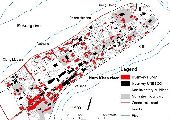
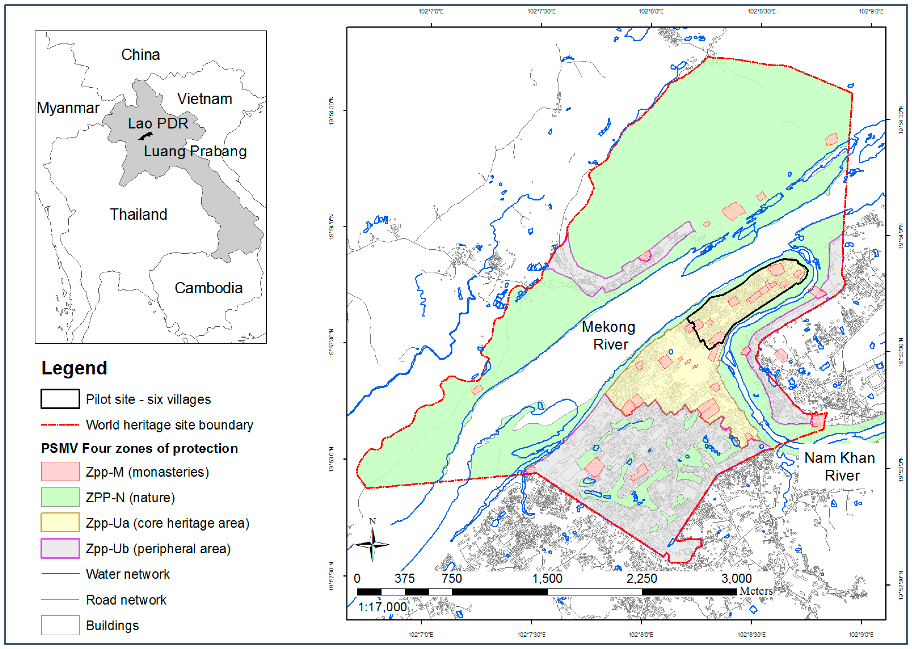
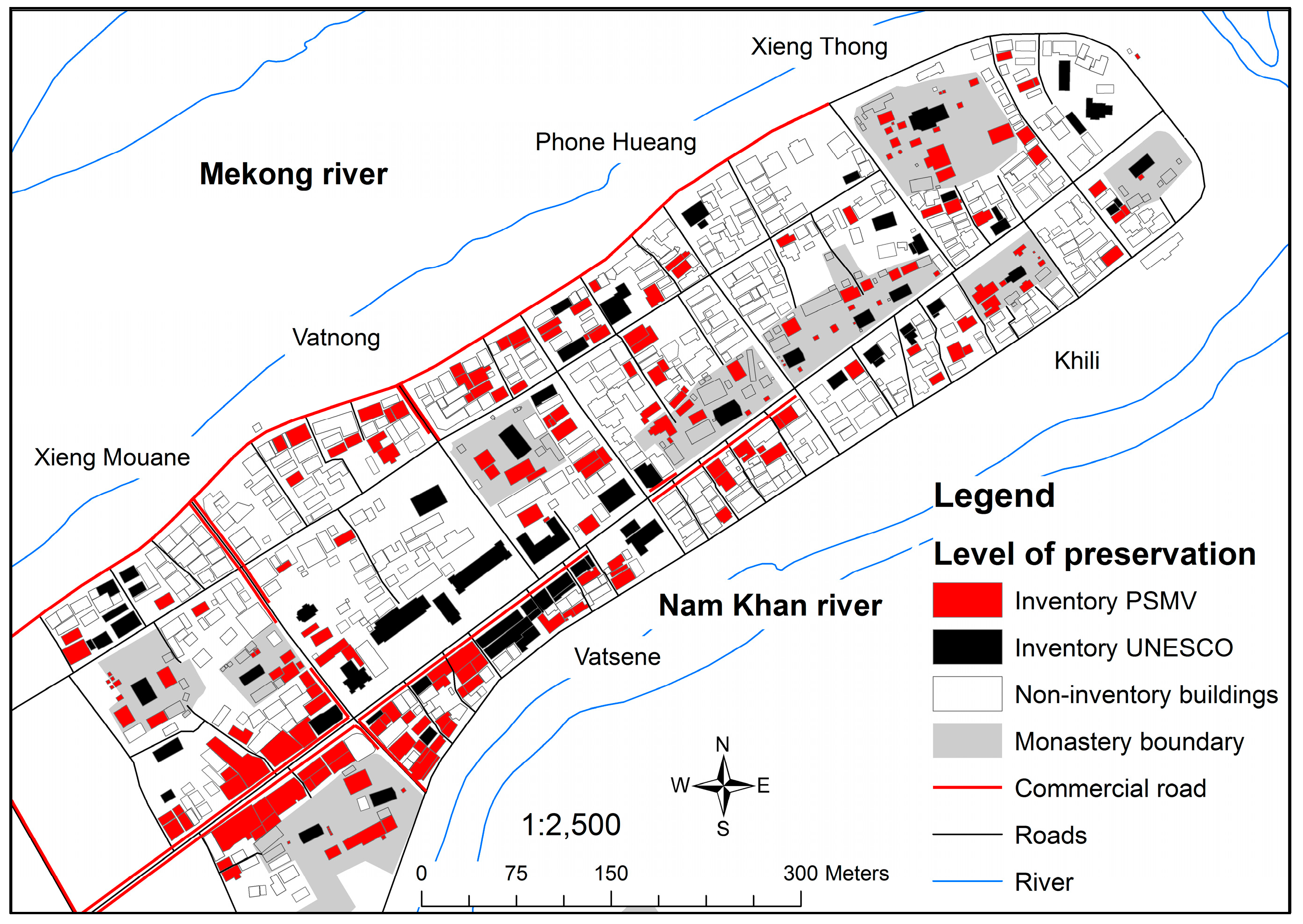
32]. There are four components of GIS application: (1) data collection; (2) development of an appropriate geospatial database; (3) development of a reliable base map; and (4) spatial analysis of the landscape. A pilot site of six villages in the core heritage area, Zpp-Ua, was identified based on significant representation of inventory buildings (206 out of 611, or 34%).
Figure 1 also displays the location of the pilot site in the core heritage area, which is enclosed by a black line.
4.1. Data Collection
It is important to identify the essential data required for spatial analysis. During the development of the PSMV, indicators that were prone to change over time were identified [
13] (
Table 1). In 1999, the DPL and the Chinon Development and City Planning Agency (ADUC) collected the indicators for the urban morphology study, architectural study, and land survey. They were documented in the PSMV maps. It was considered the closest to the original state since the inscription of the heritage site. In order to update the indicators, authors and the Construction and Restoration Unit of the DPL conducted an extensive field survey of each building in the pilot site. Indicators were verified by local architects during the survey. All indicators and terminologies used in this study follow the definitions in the PSMV.
4.2. Development of an Appropriate Geospatial Database
Building attributes are stored and managed in the free and open source software (FOSS) database management system PostgreSQL on Linux. PostgreSQL is a database server, and any clients on other machines can access the data. PostgreSQL was used to create a heritage database in the past to manage information on heritage buildings and wetlands [
33]. The user interface was redesigned, and the database was expanded to include the updated building attributes. Commercial software ArcGIS version 9.3.1 (ESRI, Redlands, CA, United States) was selected for the spatial analysis because it was widely used and made available by other conservation projects in the DPL. Although PostgreSQL and ArcGIS run on different platforms, they are connected through a network by installing the plug-in Object Linking and Embedding Database (OLE DB) in ArcGIS. Data were converted using another FOSS PostGIS that can handle compatible data formats with ArcGIS. PostGIS provides support for geographic objects to the PostgreSQL database by specifying the type of geometry, dimension, and geographic projection.
4.3. Development of a Reliable Base Map
A base map functions as a spatial reference to identify objects in the surrounding terrain and supports advanced cartography and analysis. Hence, it is vital to identify good mapping sources if one is to develop a reliable base map for buildings. The existing base maps available at the national and local levels cannot be directly used because of inaccurate building shape, size, and location. Therefore, six mapping resources were identified [
34]: (1) scanned topographic maps; (2) a CAD drawn map for the PSMV; (3) Lao national base map; (4) Google Earth image; (5) high resolution satellite image; and (6) building polygons delineated from high resolution satellite images. The maps were re-projected or georeferenced to find the accurate building position, alignment, and polygon shapes.
4.4. Spatial Analysis
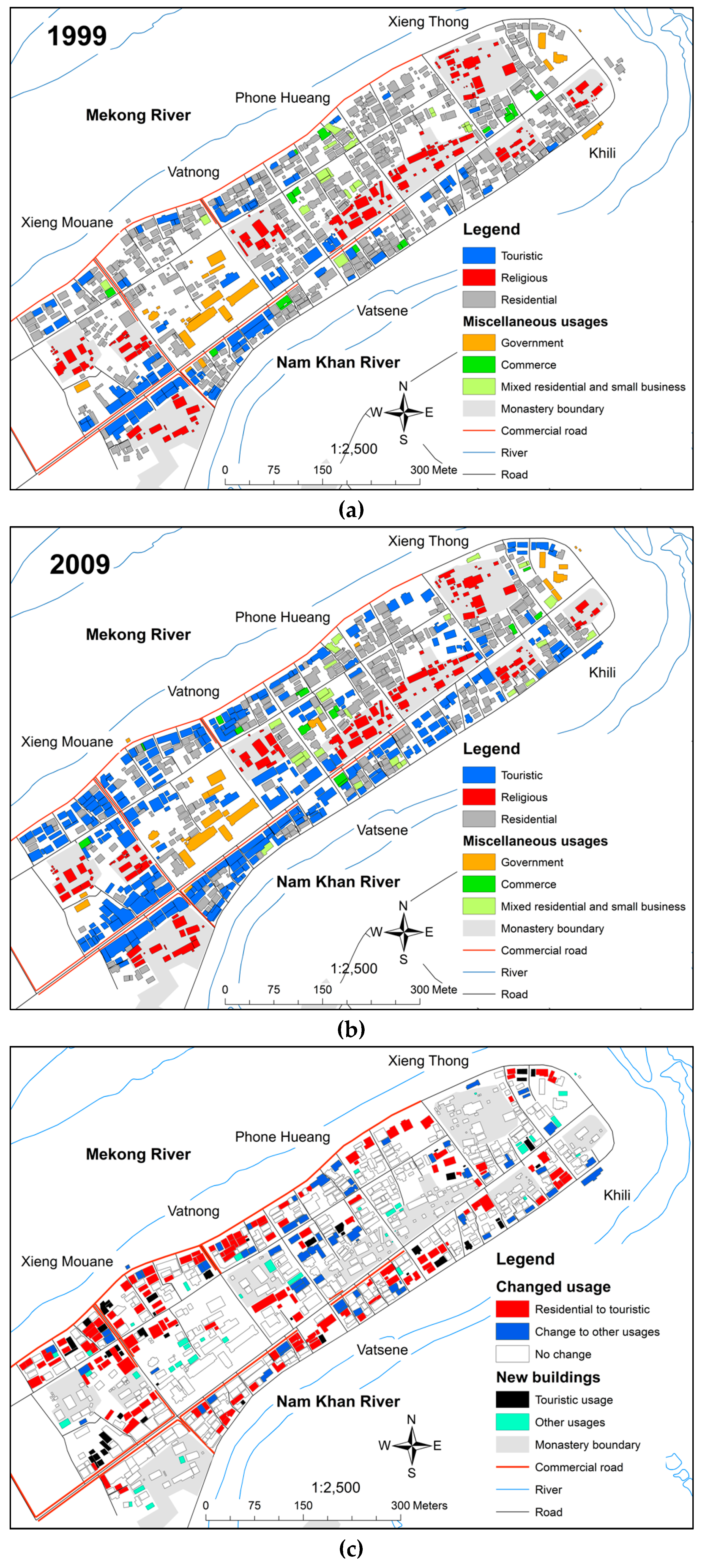
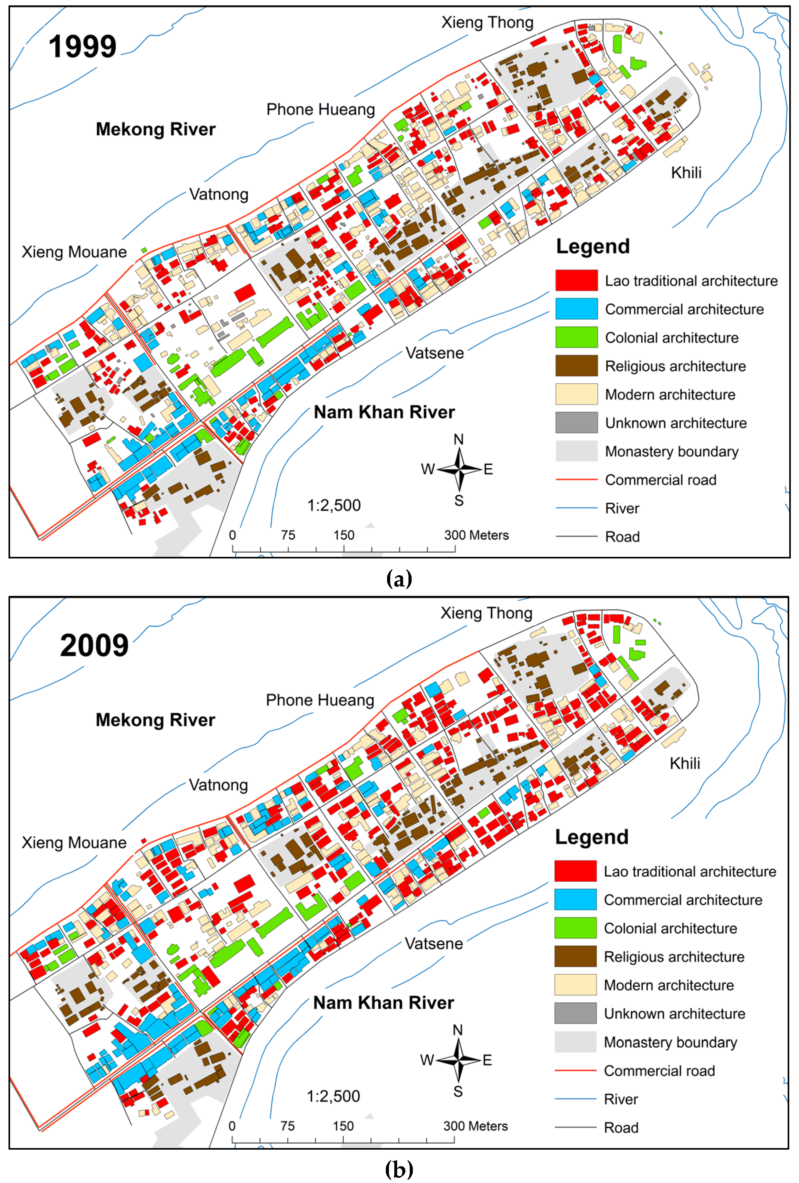
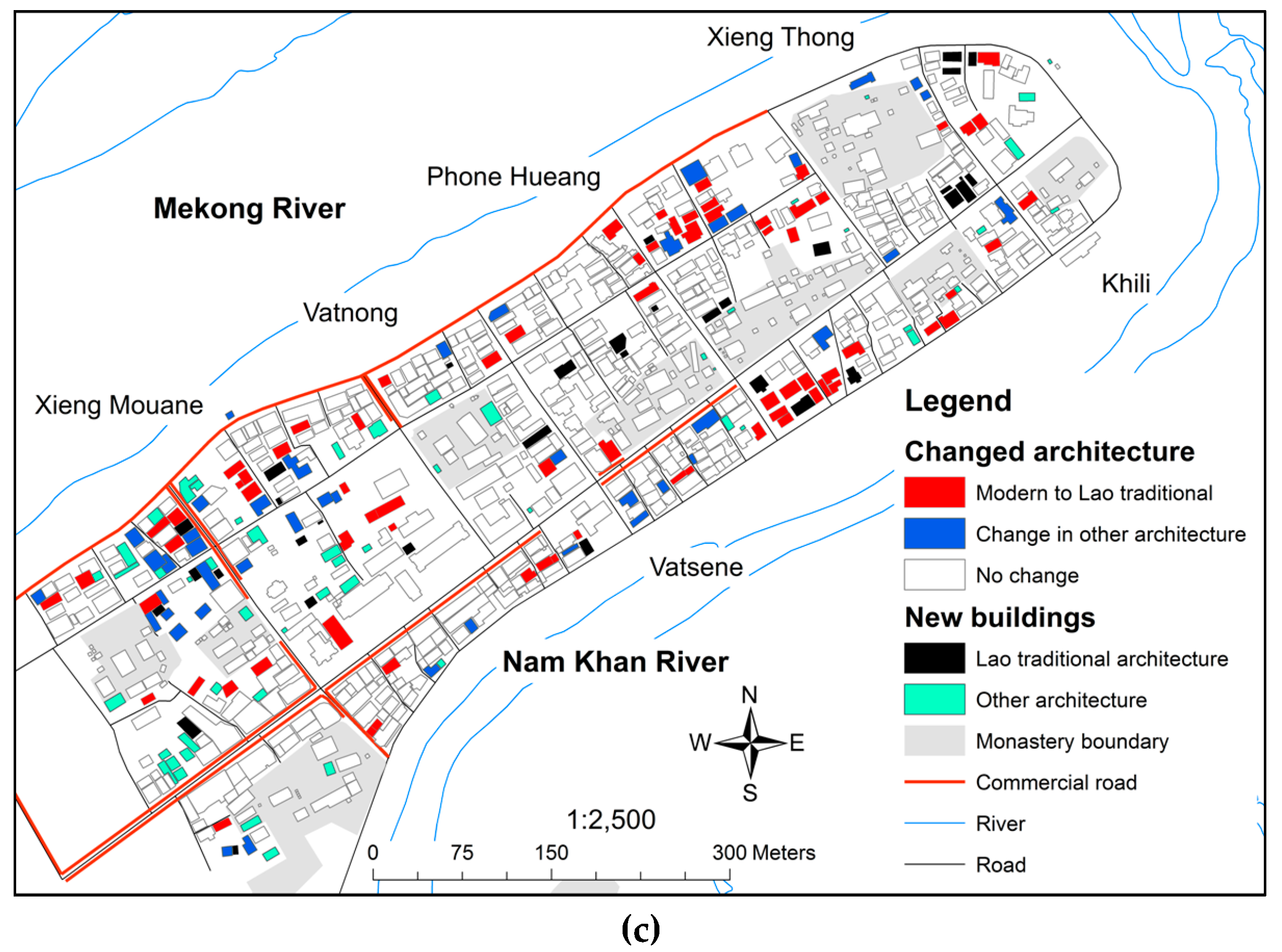
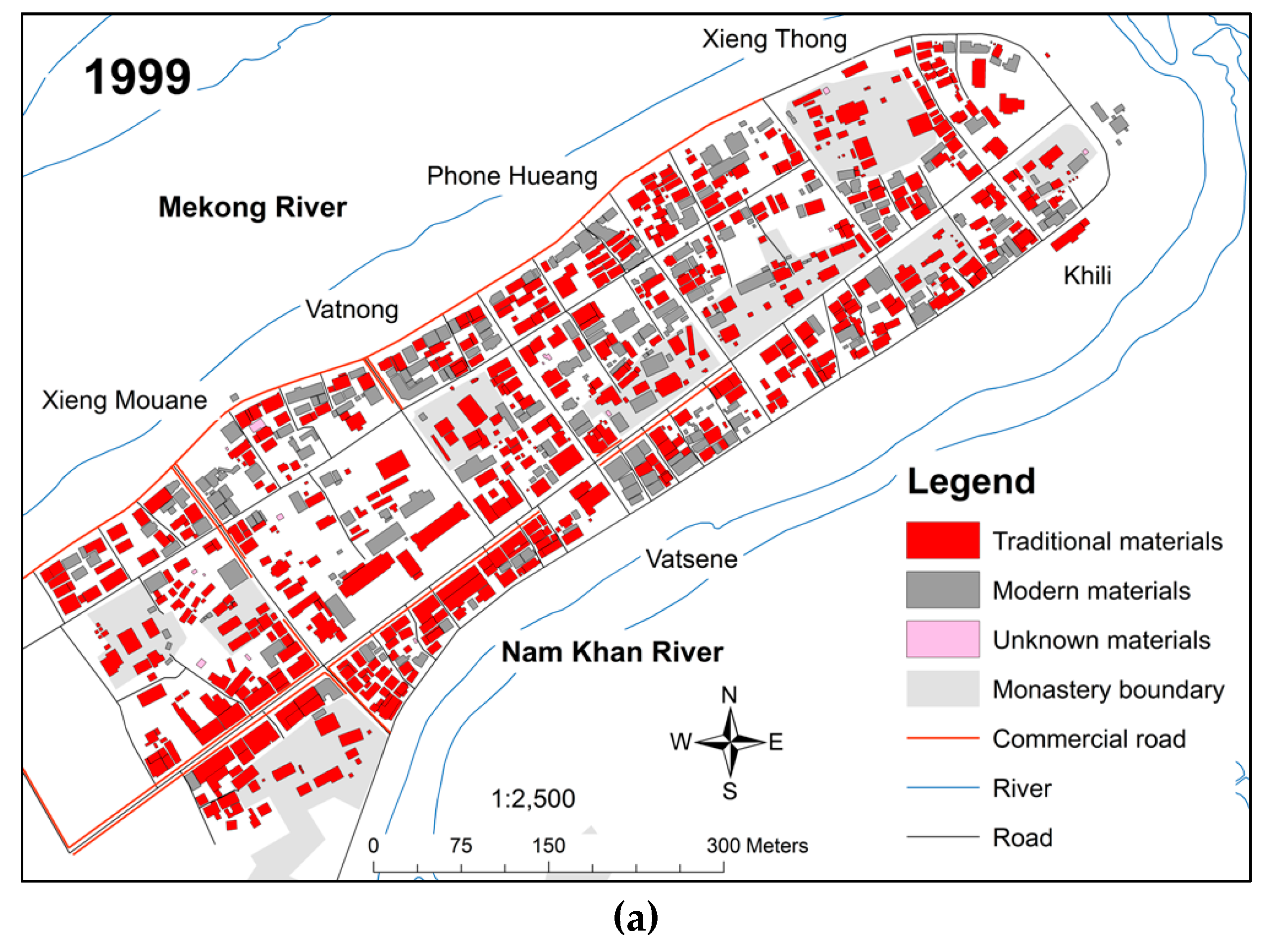
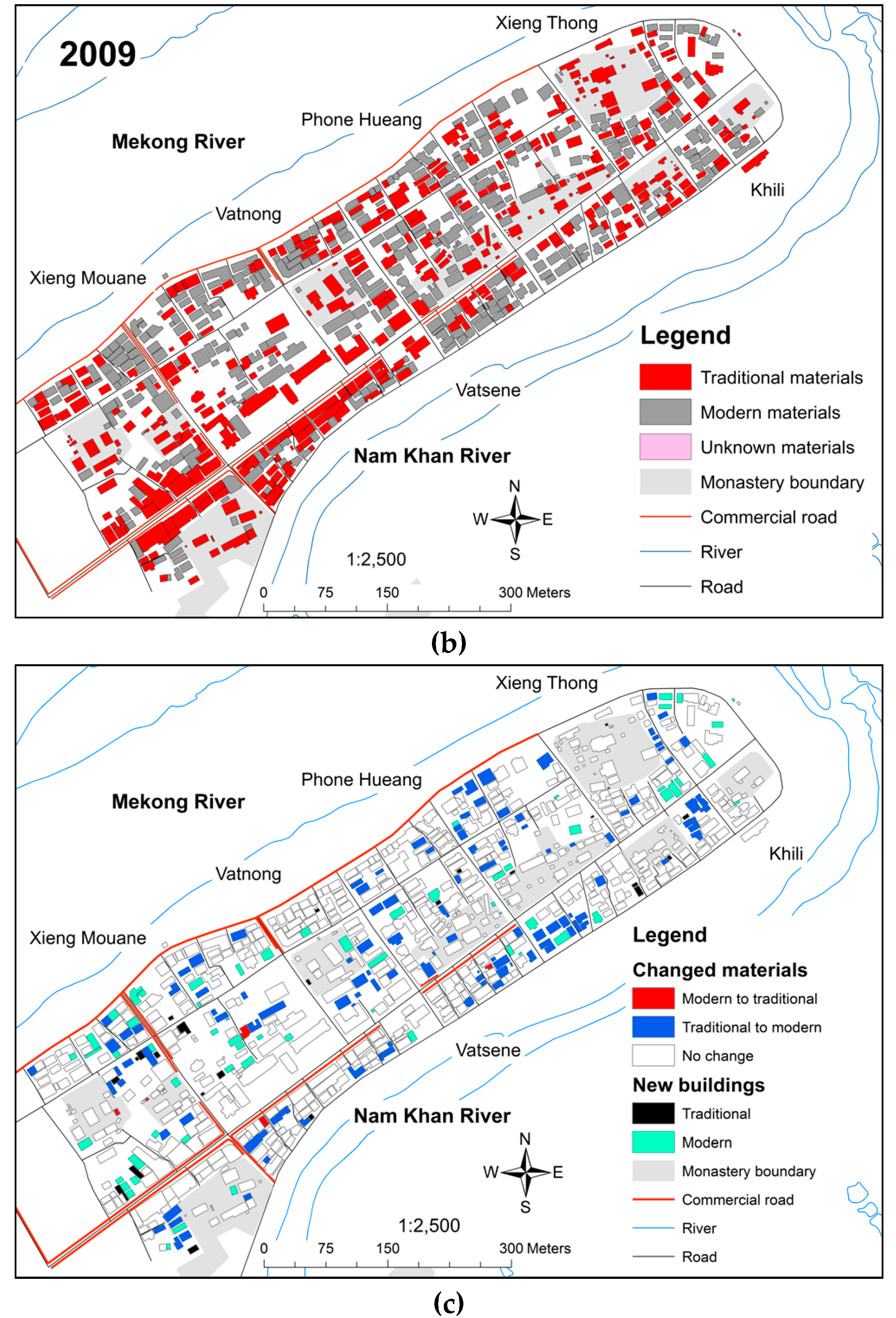
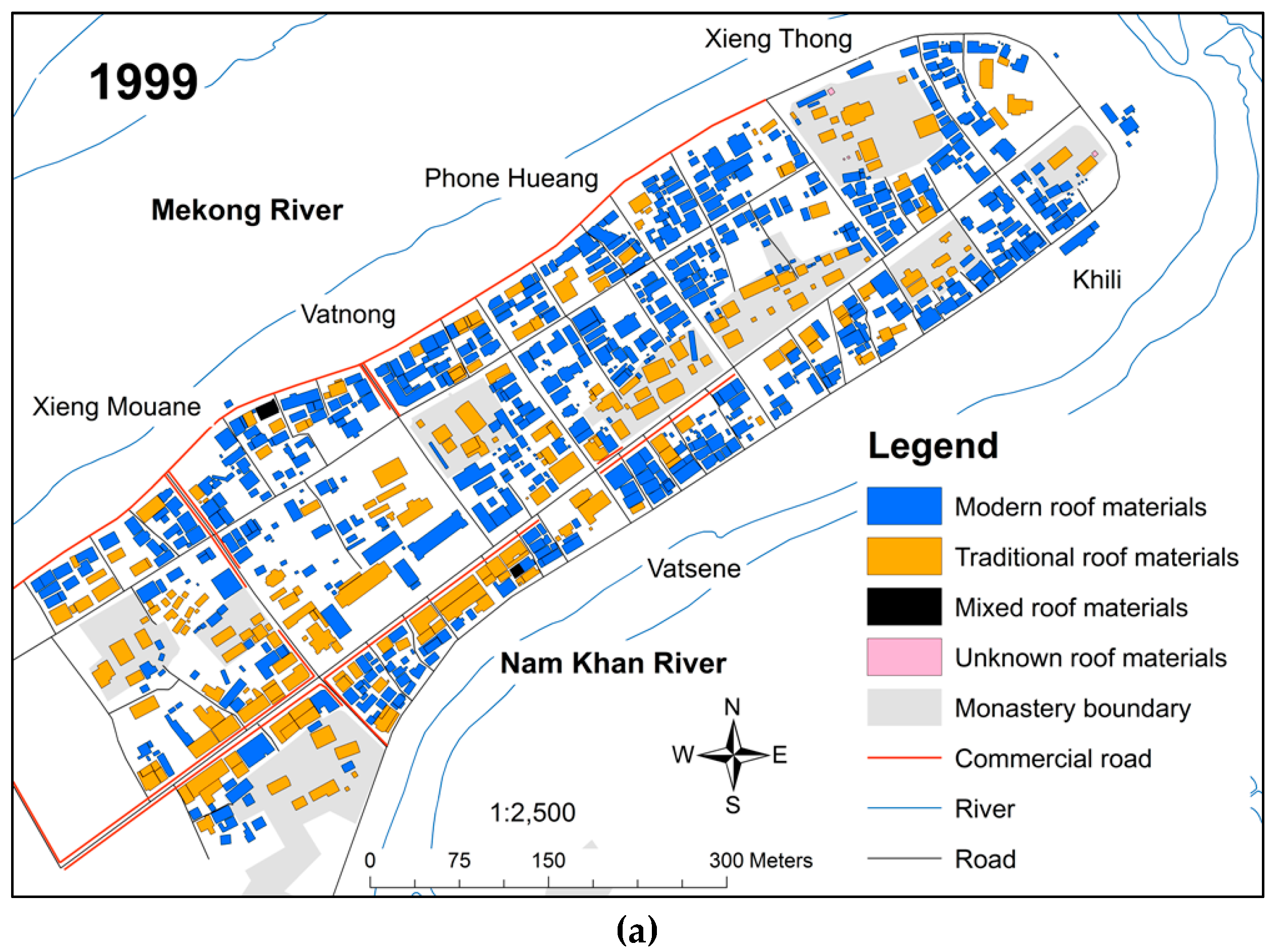
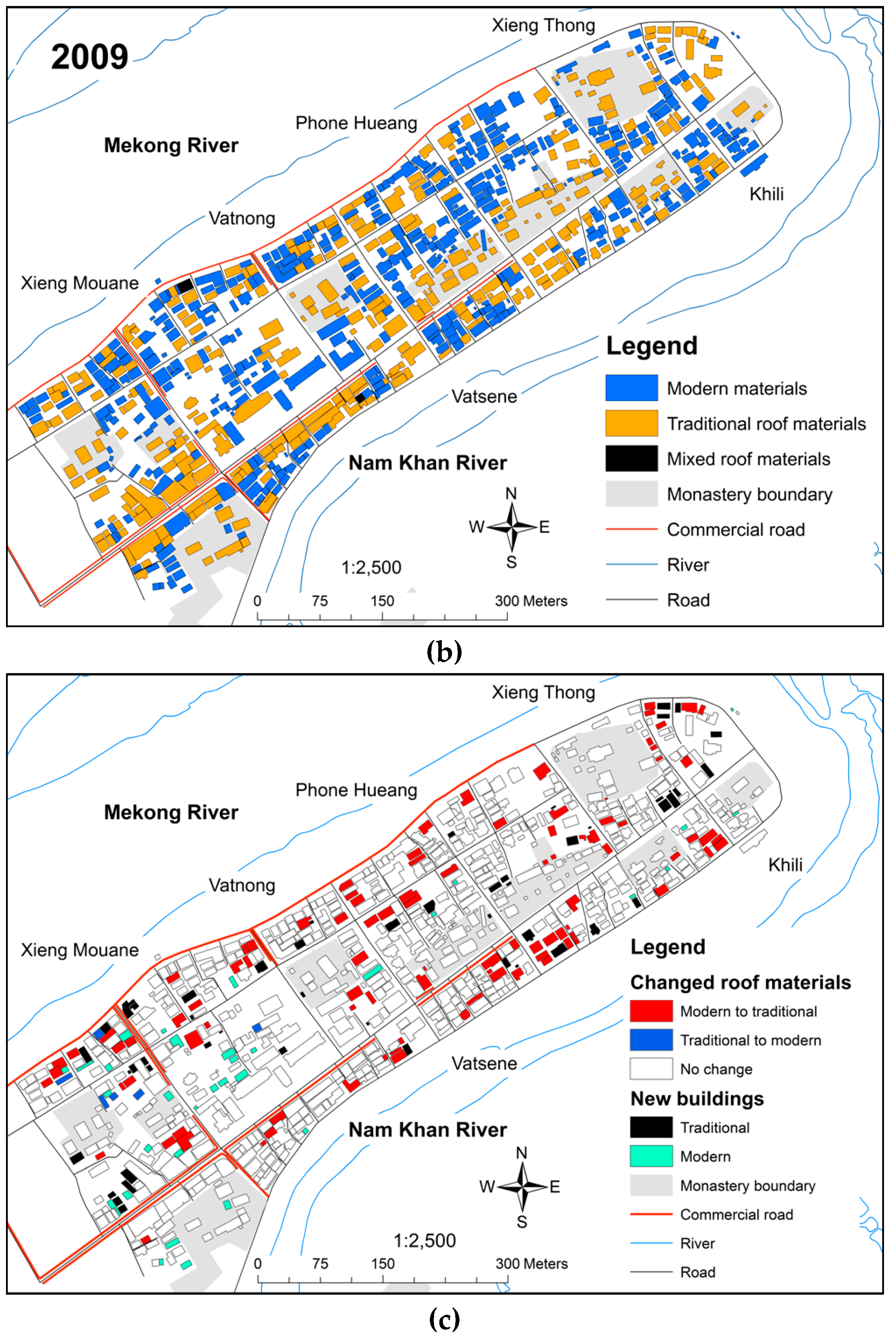
Thematic mappings in 1999 and 2009 were analyzed based on visual comparison [
35] and tracking transition in change [
36]. The constraint of spatial data and small study area faced by this study is similar to Stewart’s case study in Cairo, Egypt [
35]. This study adopted Stewart’s approach in using visual comparison to conduct discrete analysis of a rapidly changing urban landscape at the parcel level. Detail change can be examined building by building, which is crucial for heritage preservation. Each indicator has a range of different categories. It is important to track the transition from the original category to different categories [
36]. The locations of changed and unchanged areas are mapped for easier visualization and to avoid overcrowding of diverse changes.
Significant changes were interpreted through a workshop with local experts of the DPL. The results of the spatial analysis were presented before the DPL and discussed. Seven local experts from the Construction and Restoration Unit, Urban Planning Unit, and Environmental Unit participated.
4.5. Investigation with Local Residents
The workshop with local experts of the DPL helped to identify major changes that were worthwhile to investigate further with local residents. The investigation aimed to find the reason behind change in the built environment from the local residents’ perspective. The use of GIS is instrumental in identifying buildings that have changed significantly. The whole cohort, which refers to all local residents living in the changed buildings, was interviewed. The list of plausible factors were derived from literature [
22] and identified through workshop. Face to face interviews were conducted based on the list of factors, which was derived using a close-ended questionnaire. The interview was translated into the Lao language and conducted with the help of the Construction and Restoration Unit of the DPL.
6. Conclusions
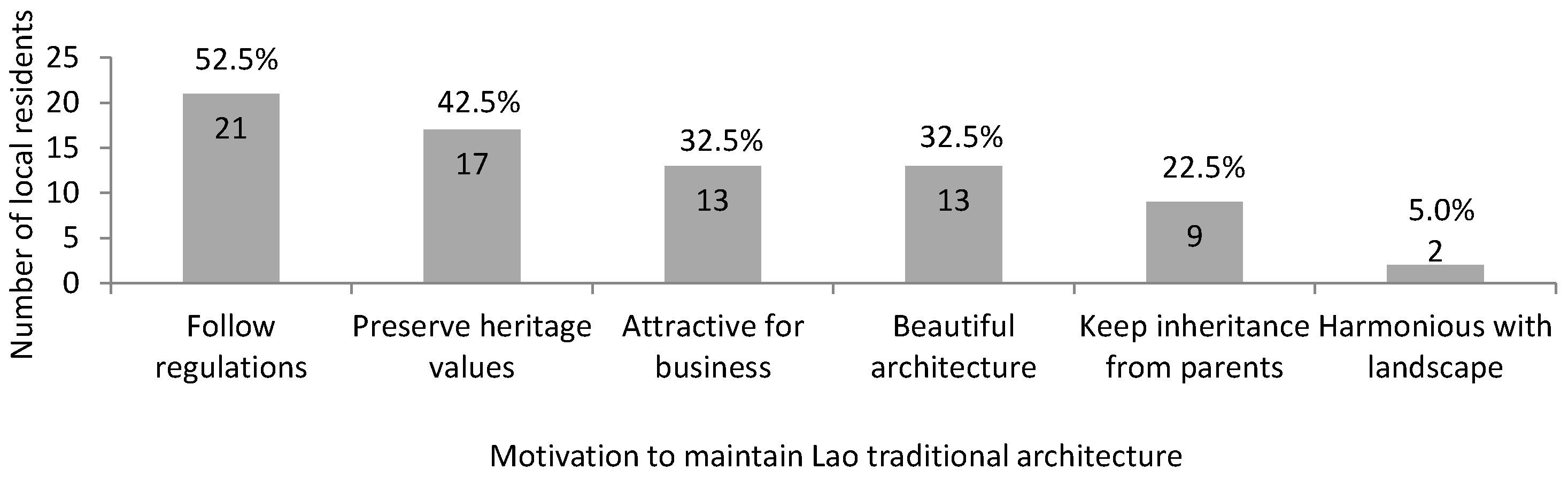
This study was able to deploy a localized GIS application with the aim of visualizing significant changes in the built environment of a pilot site in a core heritage area. Visualization using GIS and supported by the reasons behind the changes extracted from local residents was instrumental to clarifying and comprehending change in Luang Prabang. Four significant changes were identified between 1999 and 2009. First, an evident shift in building usage from residential to touristic use occurred along the riverbanks and main roads due to the demand for touristic accommodations. Second, Lao traditional architecture has replaced modern architecture due to strict regulations. In addition, residents have maintained existing Lao traditional architecture despite changing from residential to touristic use because respecting the regulations is the prerequisite to obtaining a business license. Third, modern building materials have replaced traditional building materials because modern materials have desirable qualities, are more practical to use, and locals are not restricted by regulations. Fourth, traditional roof materials have replaced modern roof materials because of strict regulations, the importance of the sharp-angled roof design, good accessibility, and durability. The main, prevalent reason behind the significant changes was the need to respect the PSMV. The PSMV has influenced the local residents’ decisions in changing their buildings. The empirical evidence has shown that although touristic buildings have increased, important building characteristics have changed within the limits of preservation regulations.
Learning from the case of Luang Prabang, visualization of urban landscape characteristics and analysis of its changes are important for policy makers because it is difficult to perceive the entire landscape and its evolution without mapping its layout. The local authorities implemented preservation regulations to ensure that development occurs without compromising the outstanding universal value. The PSMV, the current regulatory tool enforced, is applicable and functioning to preserve the heritage site. Effective enforcement of the regulatory tool requires the commitment of local authorities and the cooperation of the local community. Therefore, the physical intervention has effectively revived the traditional characteristics and shaped the current built environment.


