3.3.1. Global Spatial Autocorrelation Analysis
To analyze the spatial distribution between types of mountain area and land use degree in Guizhou province at the county level, the Global Moran’s I index values of the proportion of mountainous land area, proportion of construction land, cultivation coefficient, and integrated index of land use degree of 88 county-level administrative units were calculated as 0.4880, 0.6140, 0.5908, and 0.7210, respectively (
Table 5). The results suggested that the four variables mentioned above have a marked autocorrelation and clear aggregation characteristics, i.e., both high and low values for counties/districts that neighbor each other. Both satisfied the significance test at
= 0.05. The Global Moran’s I index of the proportion of mountainous land area was low, suggesting a low degree of spatial aggregation and a relative evenness of mountainous land in Guizhou province. It also suggests that the degree of spatial aggregation of the natural elements of the mountainous land area in Guizhou province was lower than for the humanistic elements.
The Global Moran’s I index of land use degree was highest for the integrated index of land use degree, followed by the proportion of construction land and cultivation coefficient. This suggests that the cultivation coefficient has a relatively even spatial distribution and low degree of spatial aggregation. In contrast, the degree of autocorrelation of the proportion of construction land and the integrated index of land use degree were high, suggesting a remarkable spatial aggregation.
3.3.2. Local Spatial Autocorrelation Analysis
The Local Moran’s I index was used to analyze the local spatial aggregation characteristics of the types of mountain area and index of land use degree in Guizhou province at the county level (
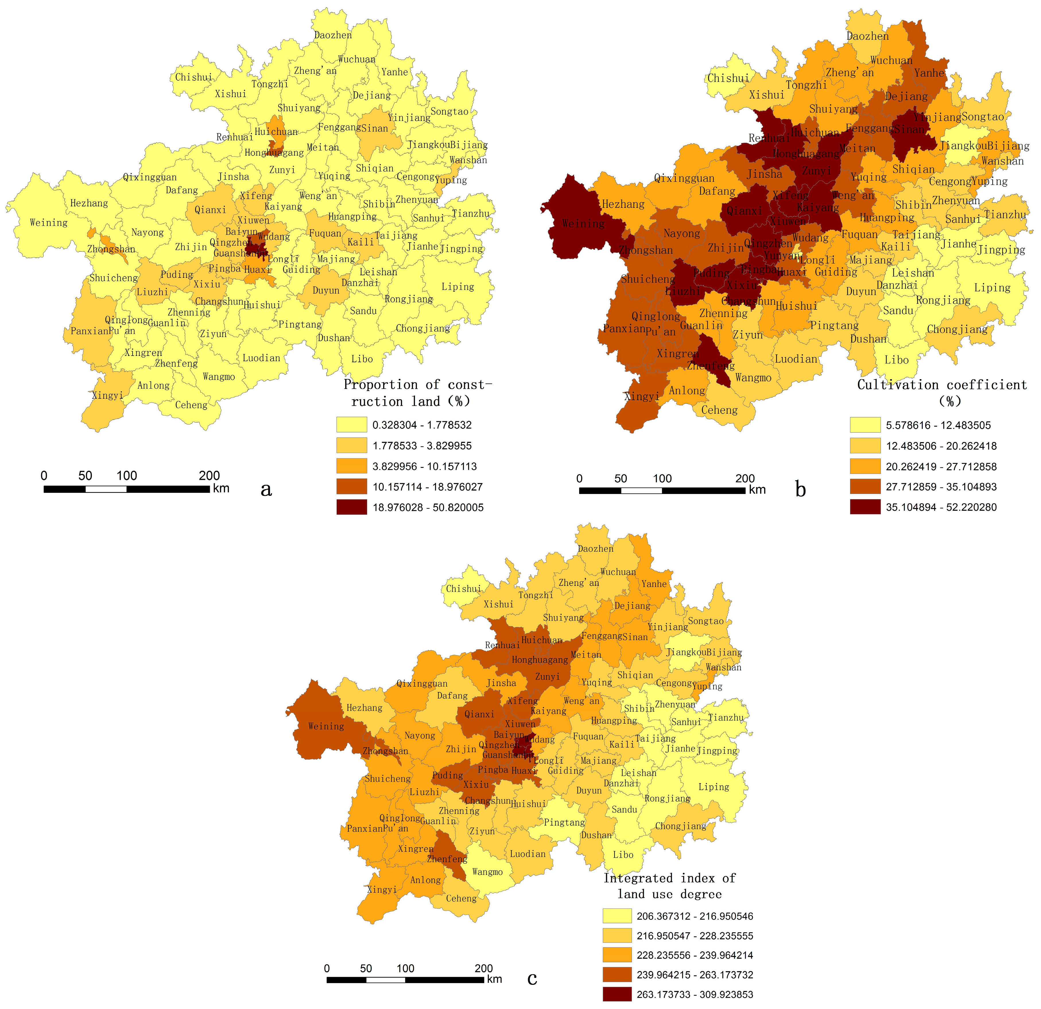
Table 6). In terms of the proportion of mountainous land area in each county, the Local Moran’s I index value ranged from −0.6542 to 4.2146. The magnitude of the range was 4.8688 and the mean value was 0.4825. The mean values of the Local Moran’s I for the proportion of construction land, cultivation coefficient, and integrated index of land use degree were 0.6071, 0.5841, and 0.7128, respectively. All three values were higher than the mean value of the Local Moran’s I of the mountainous land area, suggesting a high degree of spatial aggregation of the land use degree in Guizhou province at the county level. The county-level administrative unit with the highest Local Moran’s I value for the proportion of construction land was Nanming district, Guiyang city, with a local Moran’s I of 17.0227. Longli county in Qian’nan state had the lowest Local Moran’s I of −0.6672. The magnitude of the range between Nanming district and Longli county was 17.6899. The county-level administrative unit with the highest local Moran’s I value for the cultivation coefficient was Puding county, Anshun city, with a value of 2.5650. Chishui city had the lowest Local Moran’s I value of −0.8764. The range between Puding county Chishui city was the lowest, with a value of 3.4414.
To visually determine the types and characteristics of the spatial distribution of the proportion of mountainous land area and the index of land use degree in Guizhou province at the county level, GeoDa software was used to produce the Local Indicator of Spatial Association (LISA) aggregation graph of the proportion of mountainous land and index of land use degree (
Figure 6).
- (1)
Local spatial autocorrelation analysis of the index of the proportion of mountainous land
Twenty-two county-level administrative units were locally positively correlated in terms of the index of the proportion of mountainous land area (
Figure 6a), with 11 H-H types and 11 L-L types. The H-H type counties (districts/cities) were mainly located in: (1) the Wumeng mountain area in the west of Guizhou province; (2) the Dalou, Wuling, and Miaoling mountain areas in the north of Guizhou province, including the Weining, Hezhang, and Nayong counties of Bijie city, Zhongshan district, and the Shuicheng and Pan counties of Liupanshui city; (3) Pu’an county in the southwest of Guizhou province; and (4) Zheng’an and Tongzi counties of Zunyi city, Yanhe county of Tongren city, and Nantaijiang county in the southeast of Guizhou province. The counties mentioned above, and their surrounding counties, had a high proportion of mountainous land area and aggregating characteristics were identified. The L-L type counties were mainly located in the economically developed area of central Guizhou province, including the Yunyan, Nanming, Guanshanhu, Baiyun, Huaxi, and Wudang districts, Xiuwen county, and Qingzhen city of Guiyang city, Pingba county of Anshun city, and Sandu and Libo counties of Qiannan state. The H-L type counties (regions/cities) were located in Xifeng county and Huichuan district.
- (2)
Local spatial autocorrelation analysis of the index of land use degree
Fifteen county-level administrative units were locally positively correlated in terms of the proportion of construction land (
Figure 6b), with 6 H-H types and 9 L-L types. The H-H type counties (districts/cities) were mainly located in the economically developed area of central Guizhou province, including the economically advanced city of Guiyang and its Yunyan, Nanming, Guanshanhu, Baiyun, and Huaxi districts, as well as Qingzhen city. The L-L type counties (districts/cities) were mainly located in the region administrated by the minority, including Qiandongnan State, Qian’nan State, Shibin, Zhenyuan, Jingping, Liping, and Congjian counties of Qiandongnan State, Sandu, Luodian, and Wangmo counties of Qian’nan State, and Yuqing county of Zunyi city. The L-H type counties (districts/cities) were mainly located in Wudang district and Longli county.
Thirty-one counties (districts/cities) were locally positively correlated in terms of the index of cultivation coefficient (
Figure 6c), with 15 H-H types and 16 L-L types. The H-H type counties (districts/cities) were mainly located in densely populated counties (districts/cities) in West Guizhou province, including Qixingguan district, Dafang, Jinsha, Qianxi, and Zhijing counties of Bijie city, Qingzhen city, Xifeng, and Kaiyang counties of Guiyang city, Xixiu district, Puding and Pingba counties of Anshun city, Liuzhi district and Shuicheng county of Liupanshui city, and Huagang district and Zunyi county of Zunyi city. The L-L type counties (districts/cities) were mainly located in sparsely populated regions in southeast Guizhou province, including Kaili city, Zhenyuan, Sanhui, Tianzhu, Taijiang, Leishan, Jianhe, Jingping, Chongjiang, and Rongjiangg counties in Qiandongnan State, Danzai, Sandu, Dushan, and Libo counties in Qiannan State, and Yuping county in Tongren city.
Twenty-five counties (districts/cities) were locally positively correlated in terms of the index of integrated land use degree (
Figure 6d), with 11 H-H and 14 L-L types. The H-H type counties (districts/cities) were located in the economically developed area of central Guizhou province, including the economically advanced city of Guiyang and the surrounding districts/counties, including Yunyan, Nanming, Guanshanhu, Baiyun, and Huaxi districts, Qingzhen city, Xiuwen county, Wudang district, Xifeng county, Zhijin county of Bijie city, and Pingba county of Anshun city. The L-L type counties (districts/cities) were mainly distributed in southeast Guizhou province, including Kaili city, Zhenyuan, Taijiang, Leishan, Jianhe, Jingping, Liping, Chongjiang and Rongjiangg counties of Qiandongnan State, Duyun city, and Sandu, Dushan, and Libo counties of Qiannan State. Two counties (districts/cities) were locally negatively correlated in terms of the index of integrated land use degree. The L-H type counties (districts/cities) were located in Longli county of Qiannan State. The only H-L type county was Yuping county of Tongren city.


