1. Introduction
Settlement refers to a place where people concentrate and settle down for living and production purpose. It can also be called residential settlement. According to their characteristics and sizes, settlements can be classified into two categories: urban settlements and rural settlements. Currently, there are about 590 million permanent population living in more than 2 million villages in China, so rural settlements are the main form of settlement for Chinese population [
1].
In the world, research on rural settlement geography began in the 19th century. J. G. Kohl, as the originator of rural settlement research, systematically discussed the relationship between settlement location and population concentration in his book
The Relationship between Human Traffic and Terrain in 1841 [
2]. Since then, many researchers have begun to explore the relationship between settlements and environment. For example, Dohme, Matlakowski, Hunziker et al. analyzed house forms in different regions and their adaptability to the geographical environment [
2]. Ratzel, the main representative of environmental determinism, explored the dependence of settlement distribution on the natural environment [
2]. Lugeon illustrated in detail the relationship between settlement location and environmental factors such as terrain and sunlight [
2]. Brunhes comprehensively studied the relationship between rural settlements and the environment in his book
Principles of Human Geography [
3]. Blache, the representative of environmental possibilism, analyzed the relationship between residential buildings and the environment, building materials, house forms [
4]. From 1920s to 1960s, there was more and more research on rural settlements. Demangeon in France, Kovalev in the Soviet Union and Doxiadis in Greece et al. qualitatively analyzed the formation, development, type and function of rural settlements [
5,
6,
7]. After 1960s, metrology concept was introduced in rural settlement research which then entered a qualitative and quantitative stage.
Rural Settlement in an Urban World (Bunce) [
8],
Rural Settlement and Land Use (Chisholm) [
9] and
Determination of Settlement Patterns in Rapidly Growing Rural Areas (Goodwin) [
10] were such examples. Since 2000, research on rural settlements has been focused on their spatial layout and influencing factors [
11], their spatial form and type [
12,
13,
14], the evolution and reconstruction of rural settlement patterns [
15,
16,
17], land use and landscape ecology [
18,
19] and the social perspective [
20,
21].
In China, the research on rural settlements appeared relatively later. Influenced by Western research on this topic, some researchers began to study rural settlements in 1930s. Lin published his paper
Discussion on Settlement Classification on the
Journal of Geography, Chen published his paper
Settlement near Zunyi on the
Journal of Acta Geographica Sinica and Yan published his paper
Xikang Living Geography on the
Journal of Acta Geographica Sinica [
22,
23,
24]. These researchers preliminarily analyzed the relationship between settlements and geographical environment. From 1950s to 1960s, some researchers extensively studied settlement geography according to the actual situation of village and town planning in China. In 1950, Wu published his paper
How to Do Urban Survey, in which he classified settlements and proposed to use urban degree to determine whether a settlement had reached the development level of urban areas [
25]. In 1959, Zhang and Song published their paper
Basic Experience of Planning of People’s Commune Economy in Rural Areas. They put forward three principles for the layout of residential settlements [
26]. First, it should be closely related to the overall planning of commune and be conducive to further development and production. Second, it should adapt to river network. Third, it should consider the influences of various natural conditions, the original residential settlements, major traffic lines and their relationship to residential settlements. From 1970s to 1990s, Ye, Zheng, Chen et al. extensively studied rural settlements in China [
2]. Rural settlement geography and urban geography were thus developed rapidly. Jin systematically studied the formation, classification and regional differences between Chinese rural settlements in his book
Rural Settlement Geography published in 1988 and his book
Chinese Rural Settlement Geography published in 1989 [
27]. Recently, rural areas have entered a new developmental stage as the rapid progression of New Urbanization in China and the proposal and implementation of national policies such as Three Rural Issues, New Countryside, Coordination of Urban and Rural Development, Beautiful Countryside [
28]. The spatial density and form of rural settlements in China have changed significantly. A series of research on rural settlements including their form and structure [
29,
30,
31,
32], their function [
33,
34], their evolution and driving mechanism and the hollowing and arrangement of rural settlements [
35,
36,
37] has been conducted. The research areas mainly include the southwest Karst mountain area, the hilly area of the Loess Plateau, the Huang-Huai-Hai plain, the Bohai rim region and the Chang-Zhu-Tan area [
30,
35,
38]. Integrated application of GIS, RS and landscape methods for rural settlement research is increasing and macro-scale research is changing to micro-scale research.
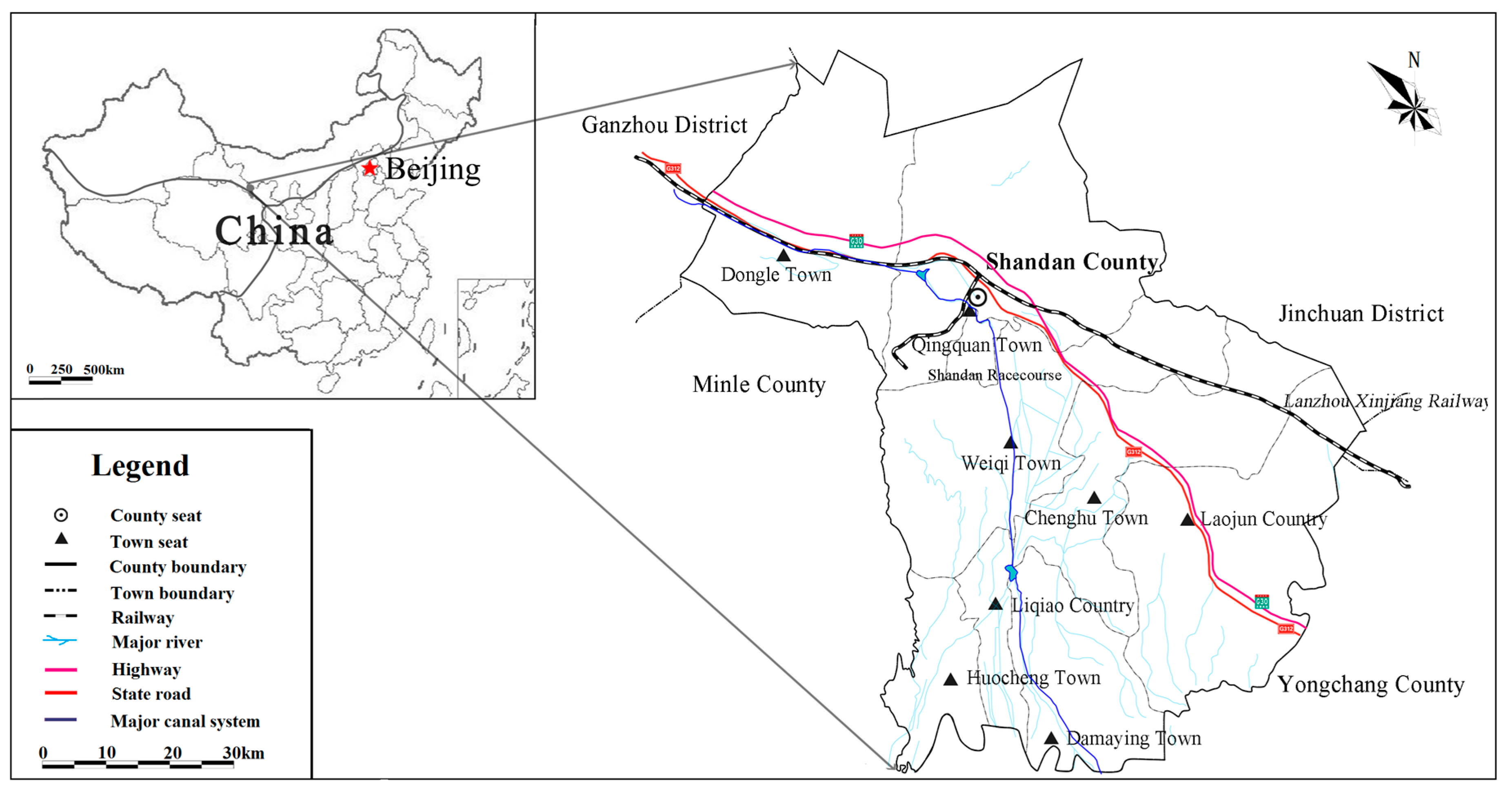
In China, oasis area accounts for 3–5% of the total area of arid region but it can provide resources supporting more than 90% of the population and create more than 95% of industrial and agricultural output value. Shandan County is a typical arid oasis region. Rural settlements are distributed in this area and human activities such as agricultural production and processing also occur in this area. Rural settlement is the main form of spatial agglomeration of rural population in Shandan County. Water and land resources are the most basic constituents of oasis and the existence and development of rural settlements are restricted by these two factors, which eventually determine the scale and carrying capacity of rural settlements [
39]. Restricted by agricultural production technology, water and land resource endowment as well as rural population in Shandan County are closely related to the formation, scale, structure and change of rural settlements and the exploitation and utilization of water and land resources will be reflected in the settlements in oasis [
40]. With the integrated development of urban and rural areas, the residents’ quality of life in Shandan County is greatly improved. The flow of people, resources and information between urban and rural areas is being strengthened. On the one hand, rural labor force is transferred to urban areas and some rural land is converted into urban land (with urbanization rate increasing from 14% in 1998 to 42.44% in 2015). Because of large-scale population transfer, rural areas tend to “Hollowed”. On the other hand, the change of rural residents’ living standard and lifestyle lead to new requirements of production and life in rural areas. This causes the number of rural settlements to grow, the cultivated area to expand and the density of the hydrographic network to increase. The structure and form of rural land use have changed greatly, so the relationships between population and water and land resources have changed adaptively, which will affect regional sustainable development.
Water and land resources are the most basic constituents of oasis. In fact, oasis can be simply defined as a place with water in desert. The abundance of water resources determines irrigated land area, which further affects the oasis’s carrying capacity for social economy. Settlement is a place of oasis population aggregation and it is also the concentrated expression of human economic activities. The spatial layout of oasis settlements is determined by the long-term interaction between settlements and the environment. The spatial association between oasis settlements and water and land resources is an important factor influencing the adaptability of the relations among population, land and water. Shandan County, located in the middle of Hexi Corridor, has special geographical location, where water and land resources are scarce, the economy is relatively weak and the ecological environment is fragile. Shandan Country is a typical arid oasis region and the relationships between population and land resources and between population and water resources are complex and sensitive, which will affect regional sustainable development by different allocation of resource [
40]. Therefore, we explored the temporal-spatial differentiation of the rural settlement patterns in Shandan County from 1998 to 2015. Further, we studied the spatial association between rural settlements and water and land resources. Finally, we revealed the general pattern of the temporal-spatial change of rural settlements. The results might provide a theoretical basis for the reasonable utilization of water and land resources in Shandan County, help provide decision-making basis for the government and achieve regional sustainable development. Meanwhile, this study is important for deepening and expanding the theory of research on oasis settlements, guiding the construction of new socialist countryside, scientifically planning and building rural settlements and promoting the integrated development of urban and rural oases.
5. Conclusions
We analyzed the temporal-spatial differentiation of the rural settlement patterns in Shandan County using 1 km × 1 km sq. grids, GIS quantitative analysis, grid analysis, spatial hotspot detection and spatial association model. Further, we studied the spatial association between rural settlements and water and land resources. The conclusions are as follows.
- (1)
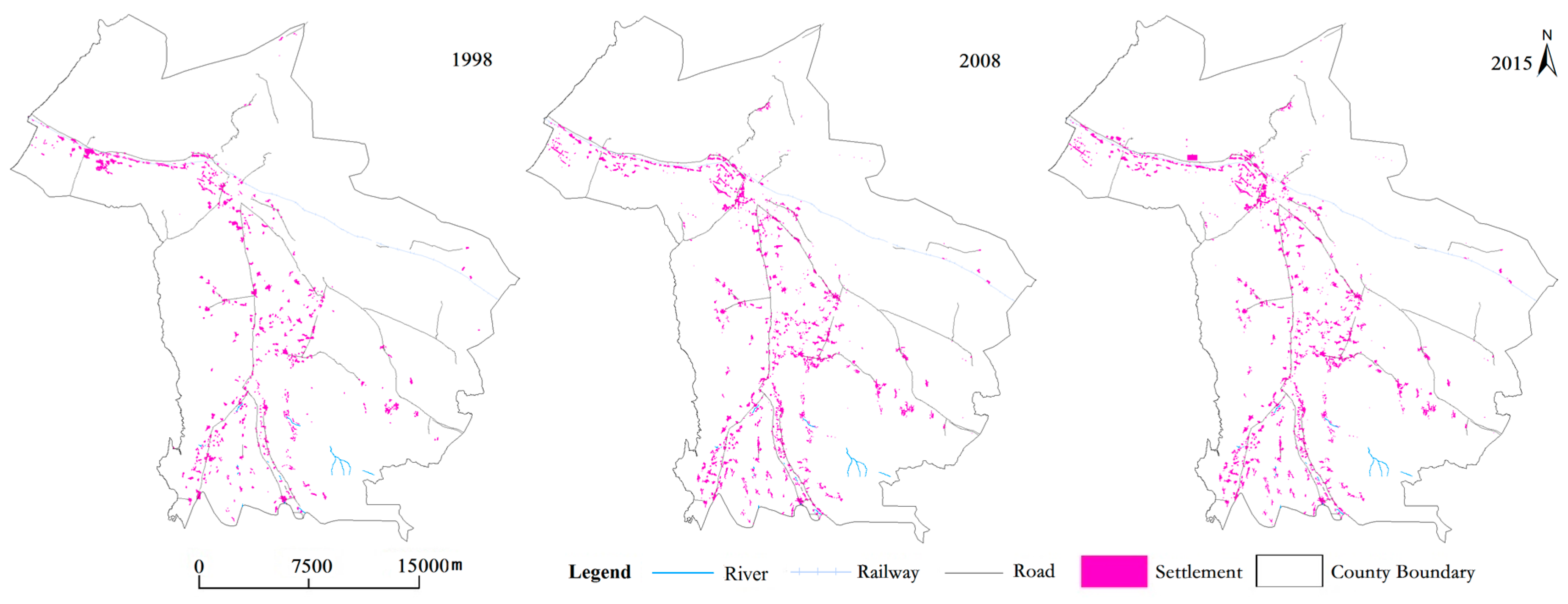
On the time scale, the total area of rural settlements in Shandan County expanded rapidly and the rural settlements tended to be more dispersed from 1998 to 2015. The increase in the number of rural settlement patches led to a higher density and a smaller average area of rural settlement patches. The CA, NP, MPS, MAXP, MINP and PD changed more rapidly from 1998 to 2008 than from 2008 to 2015. In the second period, the indices mentioned before did not change significantly. The formation of new small settlements and the division of large settlements contributed to the increase in the number of solo and small settlements.
- (2)
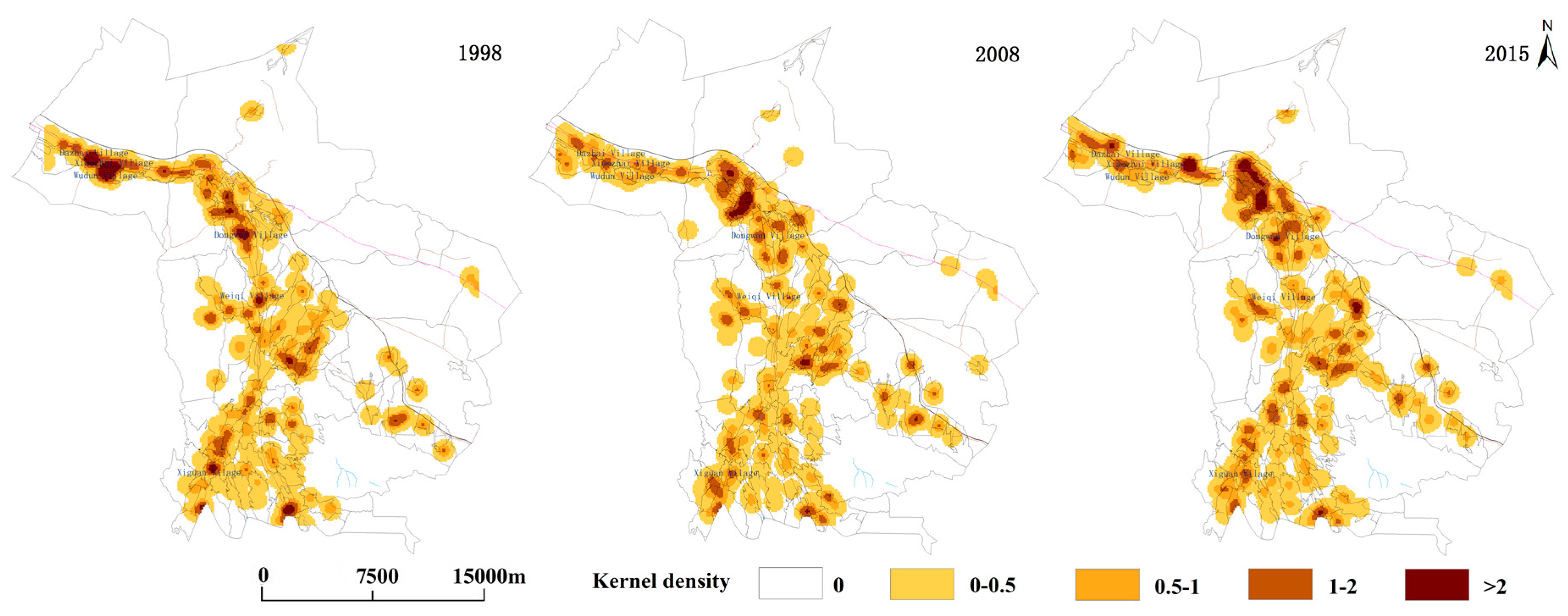
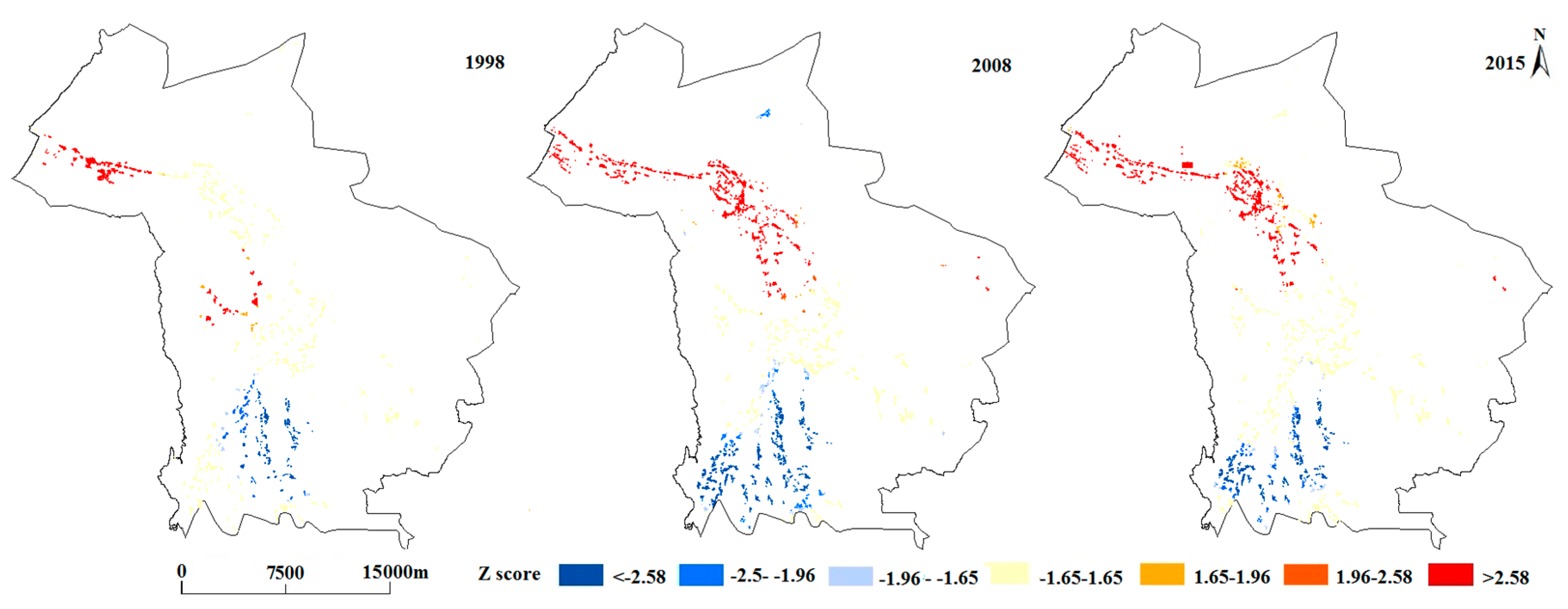
On the spatial scale, the kernel density of rural settlements in 1998, 2008 and 2015 are basically consistent. Rural settlements mainly distribute along major roads and the hydrographic network and then the kernel density of rural settlements decreases in the direction away from these roads and the hydrographic network. In 1998, the settlement-intensive regions were relatively dispersed. The number of such regions was large but the area of each was small. In 2008 and 2015, the settlement-intensive regions were more concentrated. Their number decreased but the area of each increased. In addition, there is spatial difference in the distribution of hotspots and coldspots. In other words, large-scale rural settlements densely distribute in some regions and small-scale rural settlements sparsely distribute in other regions of Shandan County. From 1998 to 2008, the hotspot zone and coldspot zone expanded. From 2008 to 2015, the hotspot zone did not change significantly, whereas the area of coldspot zone decreased significantly.
- (3)
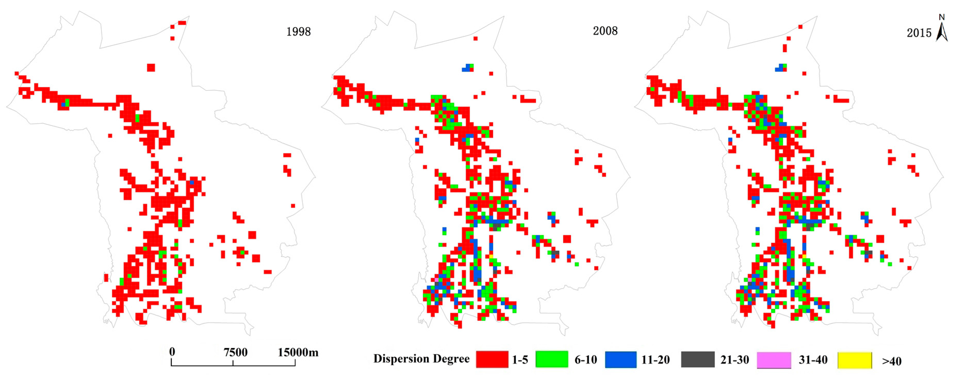
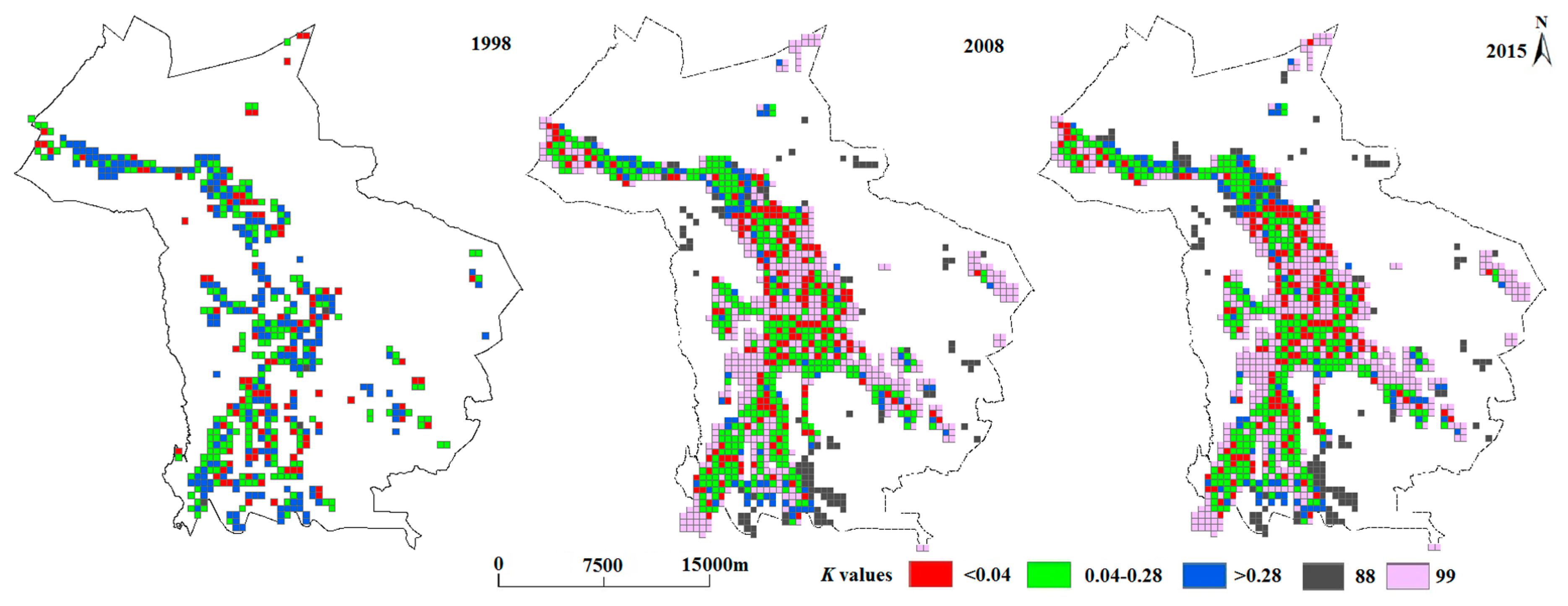
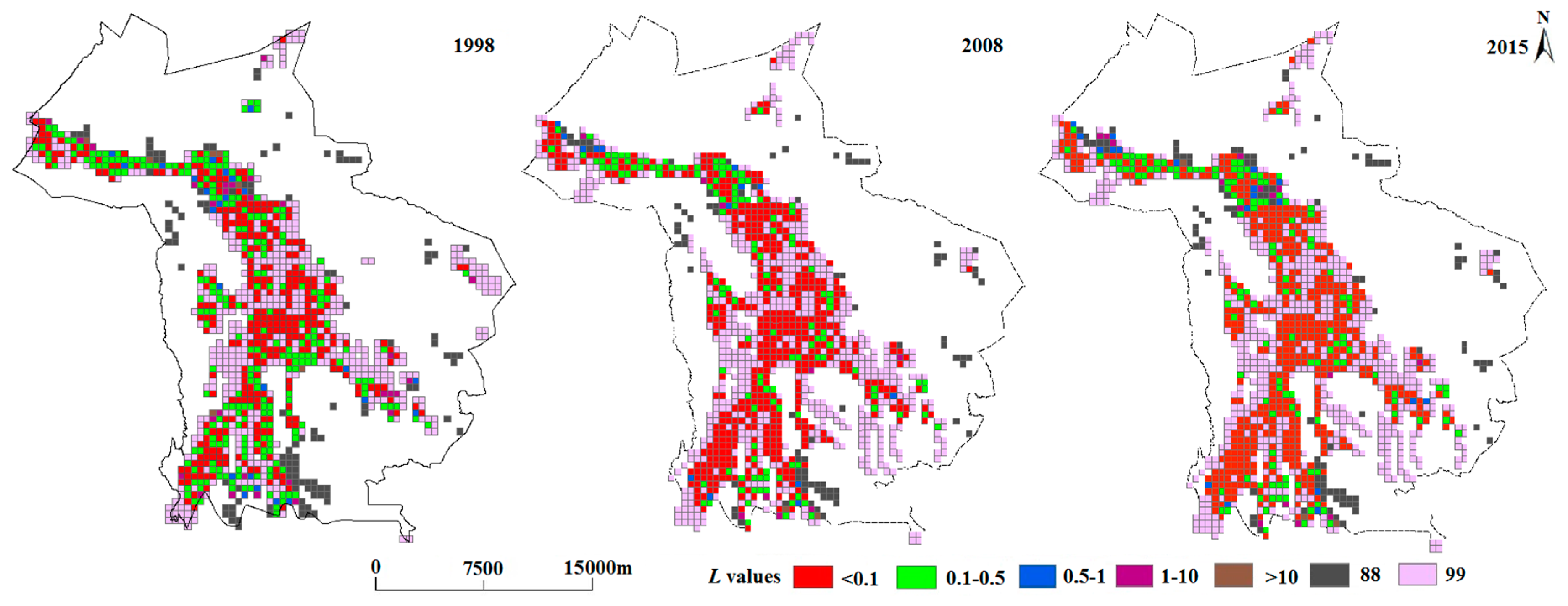
From 1998 to 2008, the dispersion degree of rural settlements increased. After 2008, the dispersion degree of rural settlements tended to be stable. In 1998, rural settlements in Shandan County were relatively concentrated and there were 95.35% grids in which the dispersion degree of rural settlements was below 5.0. In 2008 and 2015, rural settlements tended to be more dispersed and the proportion of grids in which the dispersion degree was above 6.0 increased to 27.68% and 29.3%, respectively. There were even grids in which the dispersion degree was above 21 and they accounted for 1.52% in 2008 and 1.59% in 2015. These lead to the dispersion, hollowing and disorder of rural settlements in Shandan County.
- (4)
The spatial distribution of rural settlements in Shandan County is closely related to that of cultivated land and the hydrographic network from 1998 to 2015. It can be expressed in three kinds of spatial relationships: conflict, balance and no conflict. There is a conflict between rural settlement and land resources and the conflict in 2008 and 2015 has weakened compared with 1998. In contrast, there is almost no conflict or a balance between rural settlements and water resources from 1998 to 2015.After 2000, the expansion of cultivated land led to the expansion of the hydrographic network. The expansion rates of cultivated land and the hydrographic network were higher than that of rural settlements. Thus, there were 37.33% grids with cultivated land but without settlements and 43.86% grids with the hydrographic network but without settlements in 2008, this is the main reason for the conflict decreased between rural settlement and land and water resources.
This paper can provide a systematic framework for the theoretical and empirical research on the rural settlements in oasis at a micro scale. Different from the conventional comprehensive evaluation of the temporal-spatial distribution of rural settlements, we choose water and land resources, which are the most basic constituents of oasis, as the controlling factors for the development of rural settlements. We then explored the spatial association between rural settlements and water and land resources. Finally, we revealed the driving force of the spatial-temporal evolution of rural settlement patterns at a micro scale. This study can help guide the rural planning in oasis, promote intensive land utilization and lessen the conflict between rural settlements and water and land resources. Then, sustainable development and rural revitalization in China can be achieved. However, the study has not thoroughly and systematically discussed the essence of the spatial-temporal evolution of rural settlements in different periods and has not pointed out a direction for the spatial reconstruction of rural settlements in the future. Therefore, we will systematically analyze the evolution and driving mechanism of rural settlements under the background of rural economic and social transformation in future study. In addition, we will try to explore the spatial reconstruction of rural settlements in oasis so that a balance between land resources and population in oasis can be achieved.


