
Study of the Simulated Expansion Boundary of Construction Land in Shanghai Based on a SLEUTH Model


Abstract
:1. Introduction
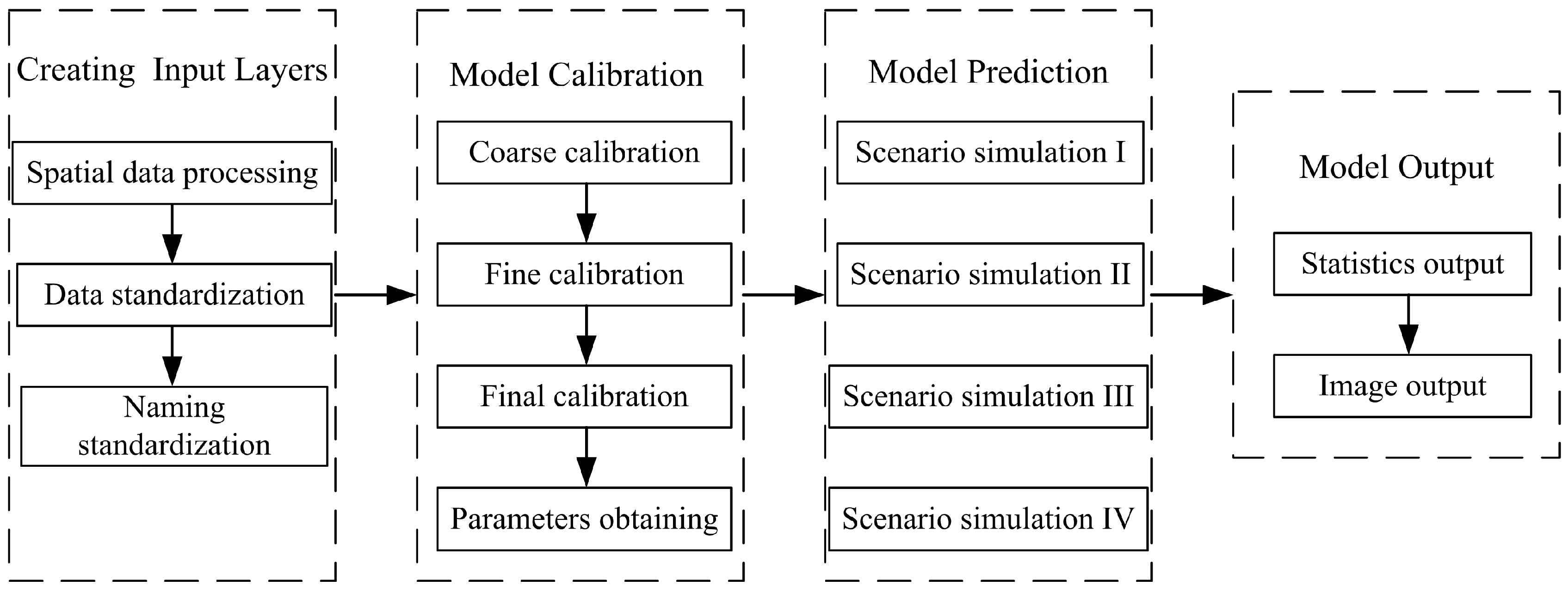
2. Materials and Methods
2.1. Research Method
2.2. Data Sources
- 1)
- The construction land area of Shanghai increased dramatically during 1990–2008. After 2008, the urbanization of Shanghai has reached a high level and the expansion of construction land has started to slow down;
- 2)
- In recent years, land use planning and urban planning in Shanghai set the goal of strictly controlling the total scale of construction land explicitly, so the expansion mode of construction land in the future will be closer to recent years;
- 3)
- In this study, the forecast of the expansion boundaries of construction land in Shanghai is considered under two scenario modes, and is constrained by economic development and the natural environment, rather than just simply relying on historical data to produce the simulations.
- (1)
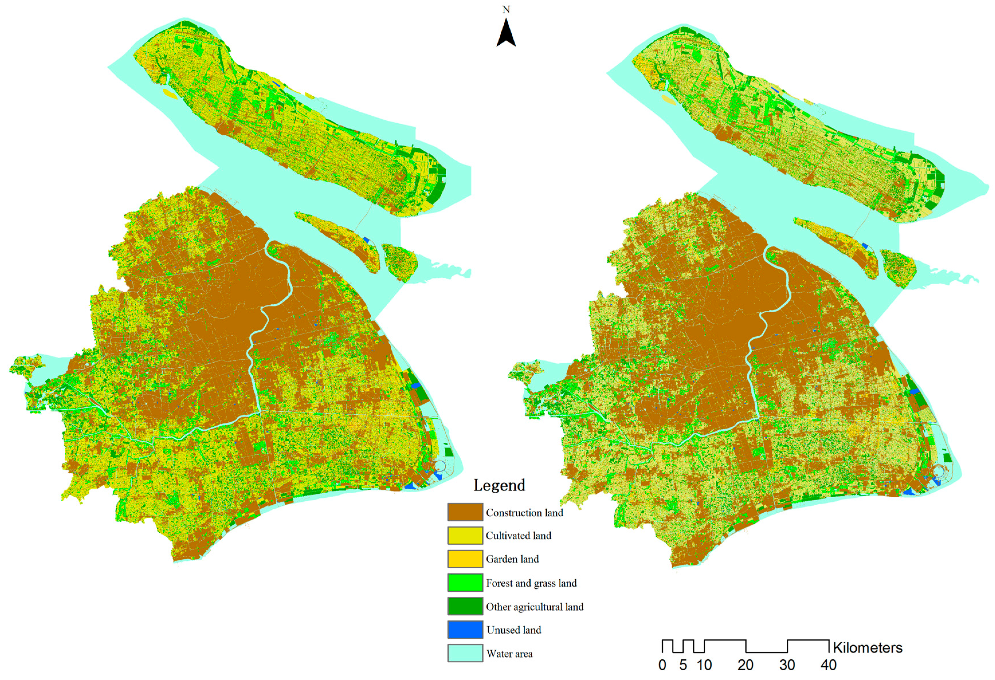
- The land use layer is generated using the land use database, and their land use types are adjusted and classified to fit the model land use types. The gray-scale values corresponding to specific land use types are shown in Table 1. To facilitate the display, land use types are still identified by color (Figure 2).
- (2)
- The urban layer, which is the layer demonstrating the existence and expansion of construction land, is generated using the land use database. Non-construction land is defined as a zero gray-scale value, while construction land is defined as a 255 gray-scale value.
- (3)
- The excluded layer is generated using the land use database. According to the requirements of urban development, restrictions on the expansion of construction land can be achieved by setting different excluded probabilities. For example, if waters are set to 100% exclusion, they can be reclassified in ArcGIS (Esri, CA, USA) and their gray-scale value can be set to 100 (i.e., if the gray-scale value is greater than or equal to 100, 100% is excluded; if the value is set between 0 and 100, the excluded probability is 0% to 100%).
- (4)
- The transportation layer is also generated by the land use database. The different road types may be given different relative weights and a greater gray-scale value corresponds to a greater weight. Non-road data are assigned a value of zero. Here, the gray-scale value of traffic land is set to 100, and the gray-scale value of non-traffic land is set to 0.
- (5)
- The slope layer is generated from the DEM data. Because Shanghai is flat, the slope values are close to 0; therefore, the slope values of the entire layer are assigned a value of 0.
- (6)
- The mountain shadow layer (i.e., hillshade layer) is only used as the background layer of the model image output and is not included in the model computation.
2.3. Scenario Modes Setting
- (1)
- Natural growth mode (Mode I): This scenario sets water (rivers, lakes, reservoirs, ponds, etc.) and wetlands as the excluded layers (100% probability is not urbanized), and other factors do not restrict urban development and construction.
- (2)
- Ecological priority mode (Mode II): This scenario considers ecological environment protection, wherein water regions and wetlands are set to 100% and are excluded from urban expansion; the cultivated lands are set to 80% and are excluded from urban expansion; park land, forests, and grassland are set to 60% and are excluded from urban expansion.
3. Results and Discussion
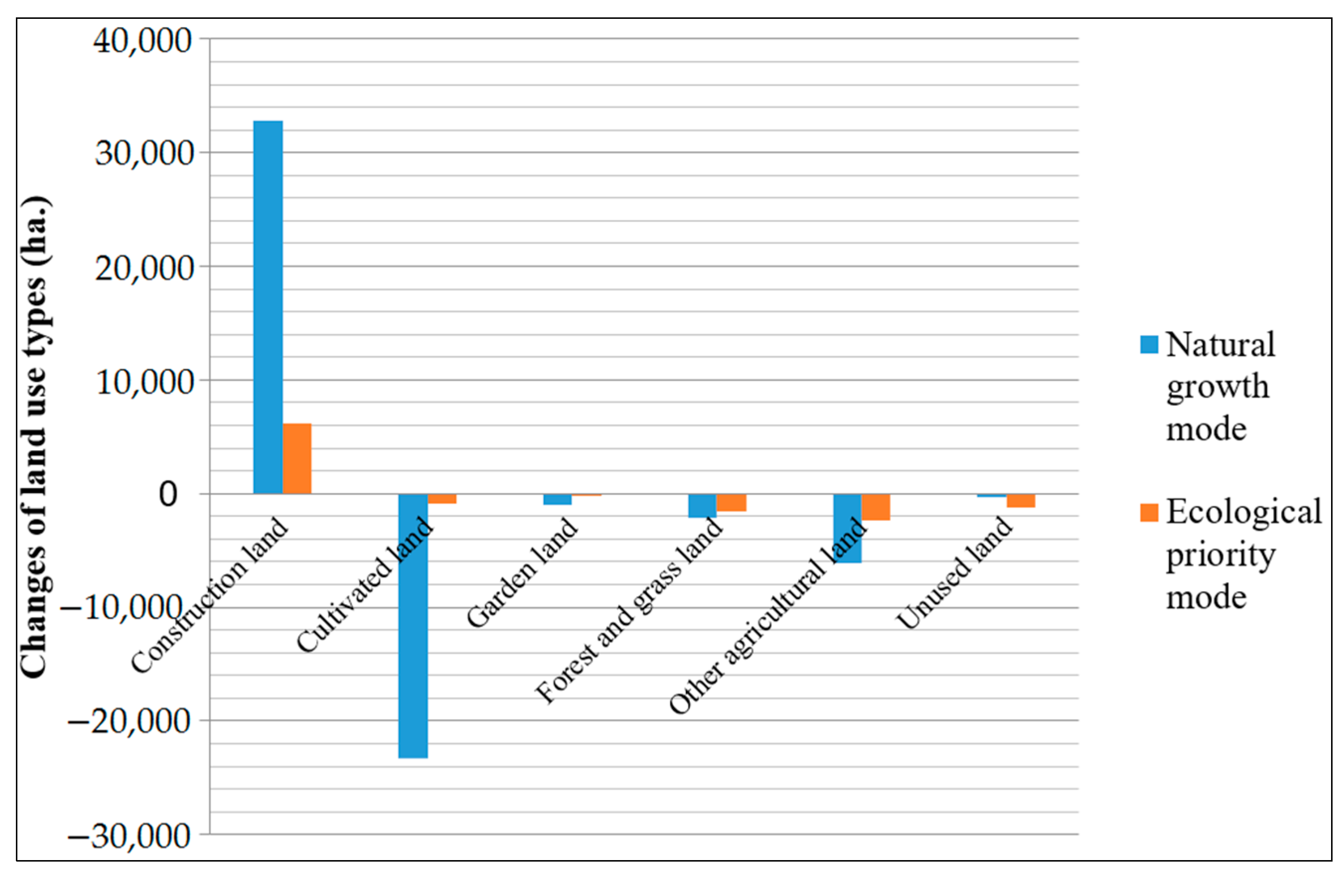
3.1. Results
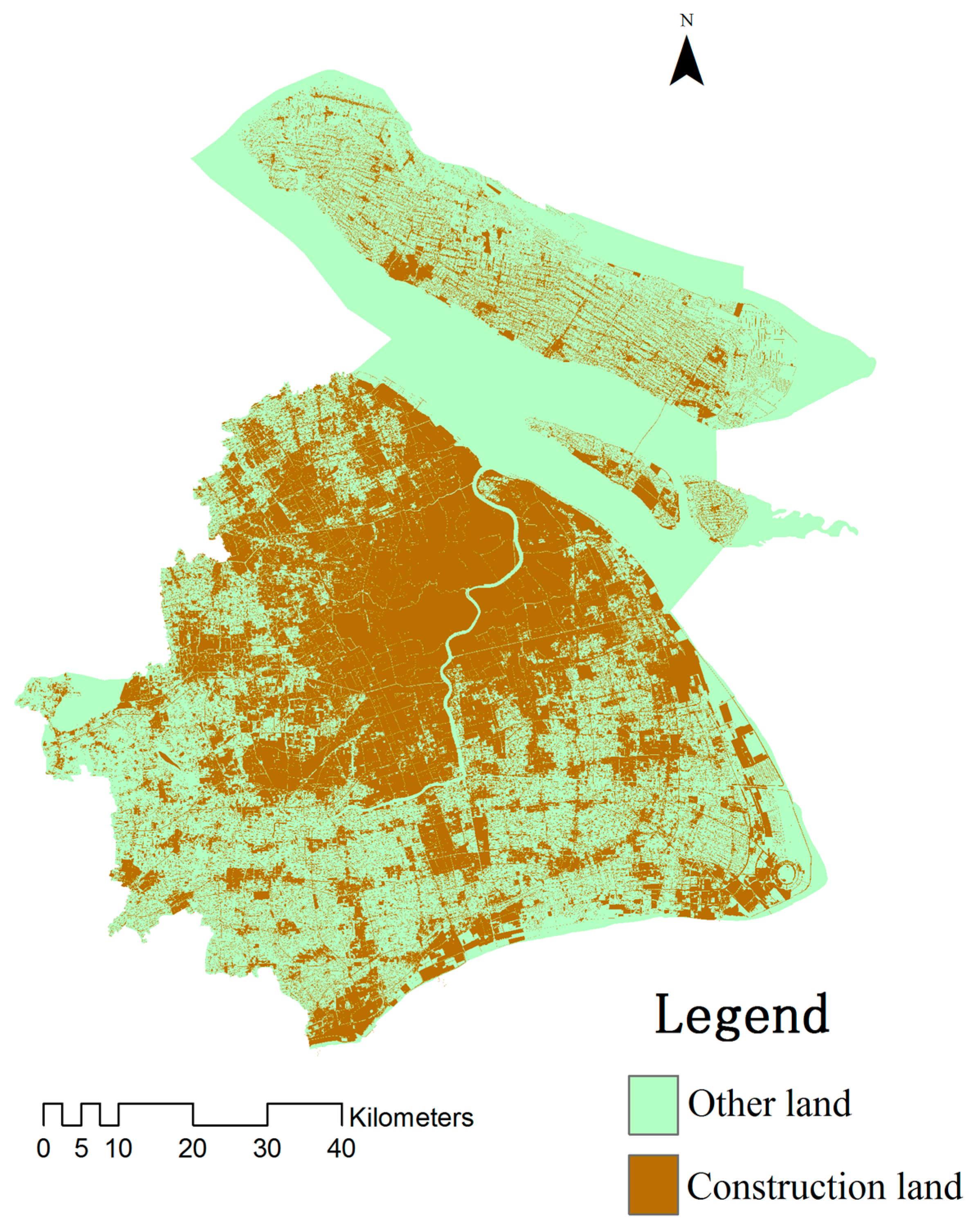
- (1)
- Natural growth mode (Mode I)
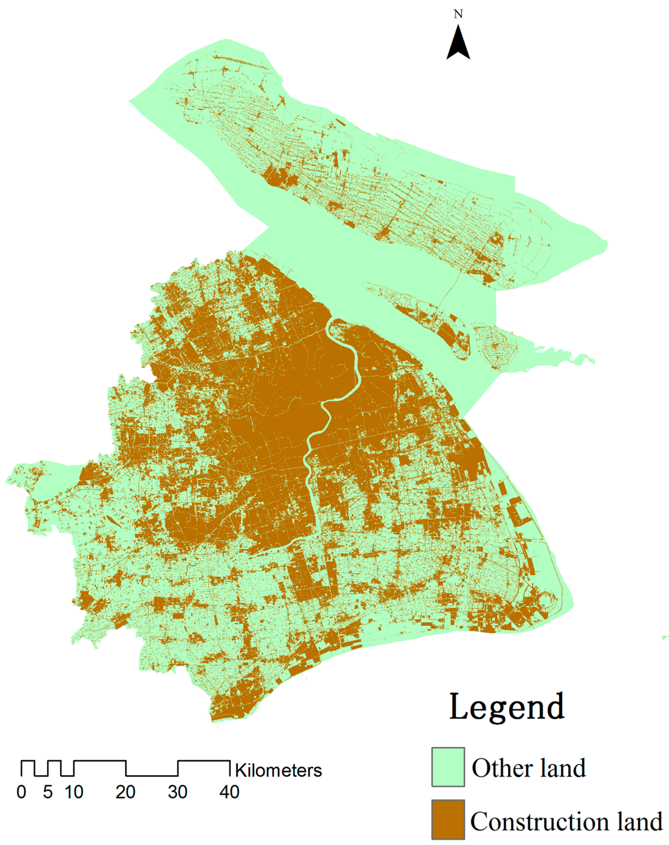
- (2)
- Ecological priority mode (Mode II)
3.2. Discussion
4. Conclusions and Suggestions
Acknowledgments
Author Contributions
Conflicts of Interest
References
- Clarke, K.C.; Hoppen, S.; Gaydos, L. A self-modifying Cellular Automaton Model of historical urbanization in the San Francisco Bay area. Environ. Plan. B 1997, 24, 247–261. [Google Scholar] [CrossRef]
- Solecki, W.D. Downscaling climate change scenarios in an urban land use change model. J. Environ. Manag. 2004, 72, 105–115. [Google Scholar] [CrossRef] [PubMed]
- Batisani, N.; Yarnal, B. Urban expansion in Centre County, Pennsylvania: Spatial dynamics and landscape transformations. Appl. Geogr. 2009, 29, 235–249. [Google Scholar] [CrossRef]
- Hua, L.; Tang, L.; Cui, S.; Yin, K. Simulating urban growth using the Sleuth Model in a coastal peri-urban district in China. Sustainability 2014, 6, 3899–3914. [Google Scholar] [CrossRef]
- Lu, S.; Guan, X.; He, C.; Zhang, J. Spatio-temporal patterns and policy implications of urban land expansion in metropolitan areas: A case study of Wuhan urban agglomeration, central China. Sustainability 2014, 6, 4723–4748. [Google Scholar] [CrossRef]
- Li, H.; Wei, Y.; Huang, Z. Urban land expansion and spatial dynamics in globalizing Shanghai. Sustainability 2014, 6, 8856–8875. [Google Scholar] [CrossRef]
- Alexander, P.; Rounsevella, M.D.A.; Dislich, C.; Dodson, J.R.; Engström, K.; Moran, D. Drivers for global agricultural land use change: The nexus of diet, population, yield and bioenergy. Glob. Environ. Chang. 2015, 35, 138–147. [Google Scholar] [CrossRef]
- Han, H.; Yang, C.; Song, J. Scenario simulation and the prediction of land use and land cover change in Beijing, China. Sustainability 2015, 7, 4260–4279. [Google Scholar] [CrossRef]
- Gao, J.; Wei, Y.; Chen, W.; Yenneti, K. Urban land expansion and structural change in the Yangtze River Delta, China. Sustainability 2015, 7, 10281–10307. [Google Scholar] [CrossRef]
- Bryan, B.A.; Nolan, M.; McKellar, L.; Connor, J.D.; Newth, D.; Harwood, T.; King, D.; Navarro, J.; Cai, Y.; Gao, L.; et al. Land-use and sustainability under intersecting global change and domestic policy scenarios: Trajectories for Australia to 2050. Glob. Environ. Chang. 2016, 38, 130–152. [Google Scholar] [CrossRef]
- Eitelberg, D.A.; Vlieta, J.; Doelmanb, J.C.; Stehfest, E.; Verburg, P.H. Demand for biodiversity protection and carbon storage as drivers of global land change scenarios. Glob. Environ. Chang. 2016, 40, 101–111. [Google Scholar] [CrossRef]
- Lavy, B.L.; Julian, J.P.; Jawarneh, R.N. The impact of past and future urban expansion on soil resources in central Arkansas, 1994–2030. Pap. Appl. Geogr. 2016, 2, 25–39. [Google Scholar] [CrossRef]
- Zhou, R.; Zhang, H.; Ye, X.; Wang, X.; Su, H. The delimitation of urban growth boundaries using the CLUE-S land-use change model: Study on Xinzhuang Town, Changshu City, China. Sustainability 2016, 8, 1182. [Google Scholar] [CrossRef]
- Liu, Y.; Hu, Y.; Long, S.; Liu, L.; Liu, X. Analysis of the effectiveness of urban land-use-change models based on the measurement of spatio-temporal, dynamic urban growth: A cellular automata case study. Sustainability 2017, 9, 796. [Google Scholar] [CrossRef]
- Liu, J.Y.; Deng, X.Z. Progress of the research methodologies on the temporal and spatial process of LUCC. Chin. Sci. Bull. 2009, 54, 3251–3258. (In Chinese) [Google Scholar] [CrossRef]
- Lu, N.C.; Huang, X.J.; Zuo, T.H.; Xiao, S.S.; Zhao, X.F.; Zhang, X.Y. Land use scenarios simulation based on CLUE-S and Markov composite model-A case study of Taihu Lake Rim in Jiangsu Province. Sci. Geogr. Sin. 2009, 29, 577–581. (In Chinese) [Google Scholar]
- Ren, Z.Y.; Li, J.; Zhou, Z.X.; Li, D.Y. Evaluation and Impacting Factors Analysis of the Effect of Land Use Change in southern Loess Plateau; Science Press: Beijing, China, 2013. (In Chinese) [Google Scholar]
- Xu, X.L.; Pang, Z.G.; Yu, X.F. Method and Application in Temporal and Spatial Information Analysis of Land Use Cover Change; Science and Technology Literature Press: Beijing, China, 2014. (In Chinese) [Google Scholar]
- Cai, Y.M.; Liu, Y.S.; Yu, Z.R.; Verburg, P.H. Progress in spatial simulation of land use change-CLUE-S model and its application. Prog. Geogr. 2004, 23, 63–71. (In Chinese) [Google Scholar]
- Couclelis, H. From cellular automata to urban models: New principles for model development and implementation. Environ. Plan. B 1997, 24, 165–174. [Google Scholar] [CrossRef]
- Clarke, K.C.; Gaydos, L.J. Loose-coupling a cellular automaton model and GIS: Long-term urban growth prediction for San Francisco and Washington/Baltimore. Int. J. Geogr. Inf. Sci. 1998, 12, 699–714. [Google Scholar] [CrossRef] [PubMed]
- Leao, S.; Bishop, I.; Evans, D. Simulating urban growth in a developing nation’s region using a cellular automata-based model. J. Urban Plan. Dev. 2004, 130, 145–158. [Google Scholar] [CrossRef]
- Castiglione, F. Agent based modeling. Scholarpedia 2006, 1, 1562. [Google Scholar] [CrossRef]
- Evans, T.P.; Kelley, H. Multi-scale analyses of a household level agent-based model of land cover change. J. Environ. Manag. 2004, 72, 57–72. [Google Scholar] [CrossRef] [PubMed]
- Parker, D.C.; Manson, S.M.; Janssen, M.A.; Hoffmann, M.J.; Deadman, P. Multi-agent systems for the simulation of land-use and land cover change: A review. Ann. Assoc. Am. Geogr. 2003, 93, 314–337. [Google Scholar] [CrossRef]
- Brown, D.G.; Page, S.; Riolo, R.; Zellner, M.; Rand, W. Path dependence and the validation of agent-based spatial models of land use. Int. J. Geogr. Inf. Sci. 2005, 19, 153–174. [Google Scholar] [CrossRef]
- Yeh, A.G.O.; Li, X. Simulation of development alternatives using neural networks, cellular automata, and GIS for urban planning. Photogramm. Eng. Remote Sens. 2003, 69, 1043–1052. [Google Scholar] [CrossRef]
- Xiang, W.N.; Clarke, K.C. The use of scenarios in land-use planning. Environ. Plan. B Plan. Des. 2003, 30, 885–909. [Google Scholar] [CrossRef]
- Foley, J.A.; DeFries, R.; Asner, G.P.; Barford, C.; Bonan, G.; Carpenter, S.R.; Chapin, F.S.; Coe, M.T.; Daily, G.C.; Gibbs, H.K.; et al. Global consequences of land use. Science 2005, 309, 570–574. [Google Scholar] [CrossRef] [PubMed]
- Foley, J.A.; Ramankutty, N.; Brauman, K.A.; Cassidy, E.S.; Gerber, G.S.; Johnston, M.; Mueller, N.D.; Connell, C.; Ray, D.K.; West, P.C.; et al. Solutions for a cultivated planet. Nature 2011, 478, 337–342. [Google Scholar] [CrossRef] [PubMed]
- Ramankutty, N.; Foley, J.A. Estimating historical changes in global land cover: Croplands from 1700 to 1992. Glob. Biogeochem. Cycles 1999, 13, 997–1027. [Google Scholar] [CrossRef]
- Amato, F.; Maimone, B.A.; Martellozzo, F.; Nolè, G.; Murgante, B. The effects of urban policies on the development of-urban areas. Sustainability 2016, 8, 297. [Google Scholar] [CrossRef]
- Amato, F.; Pontrandolfi, P.; Murgante, B. Supporting planning activities with the assessment and the prediction of urban sprawl using spatio-temporal analysis. Ecol. Inform. 2015, 30, 365–378. [Google Scholar] [CrossRef]
- Schroth, G.; da Fonseca, G.A.B.; Harvey, C.A.; Gaston, C.; Vasconcelos, H.L.; Izac, A.-M.N. Agroforestry and Biodiversity Conservation in Tropical Landscapes; Island Press: Washington, DC, USA, 2004. [Google Scholar]
- Becu, N.; Perez, P.; Walker, A.; Barreteau, O.; Le Page, C. Agent-based simulation of a small catchment water management in northern Thailand: Description of the CATCHSCAPE model. Ecol. Model. 2003, 170, 319–331. [Google Scholar] [CrossRef]
- Congedo, L.; Munafò, M.; Macchi, S. Investigating the Relationship between Land Cover and Vulnerability to Climate Change in Dar es Salaam. Working Paper, 4 April 2013; Sapienza University: Rome, Italy; Available online: http://www.planning4adaptation.eu (accessed on 4 April 2013).
- Silva, E.A.; Clarke, K.C. Calibration of the SLEUTH urban growth model for Lisbon and Porto, Portugal. Comput. Environ. Urban Syst. 2002, 26, 525–552. [Google Scholar] [CrossRef]
- Jantz, C.A.; Goetz, S.J.; Shelley, M.K. Using the SLEUTH urban growth model to simulate the impacts of future policy scenarios on urban land use in the Baltimore-Washington metropolitan area. Environ. Plan. B 2004, 31, 251–271. [Google Scholar] [CrossRef]
- Wu, X.Q.; Hu, Y.M.; He, H.S.; Bu, R.C.; Onsted, J.; Xi, F.M. Performance evaluation of the SLEUTH Model in the Shenyang Metropolitan Area of Northeastern China. Environ. Model. Assess. 2009, 14, 221–230. [Google Scholar] [CrossRef]
- Li, M.J.; Qian, L.X.; Wu, Z.F.; Cui, H.S.; Hou, X.Y. The SLEUTH model simulation of high density urban sprawl in Haizhu district of Guangzhou city. Act. Geogr. Sin. 2010, 65, 1163–1172. (In Chinese) [Google Scholar]
- Feng, W.W.; Xia, B.; Wu, X.Q.; Yang, B.L.; Feng, L.T.; Chen, H.S. Study on urban growth simulation of Dongguan city based on SLEUTH model. Geogr. Geo-Inf. Sci. 2008, 24, 76–79. (In Chinese) [Google Scholar]
- Zhang, Y.; Li, J.; Chen, Y.H. Simulation of Beijing urbanization using SLEUTH. Remote Sens. Appl. 2007, 2, 50–54. (In Chinese) [Google Scholar]
- Zhu, F.G.; Hu, H.W.; Shen, X.H.; Li, J.X. SLEUTH model-based prediction of urban growth of Shanghai. Chin. J. Ecol. 2011, 30, 2107–2114. (In Chinese) [Google Scholar]
- Cui, F.Q.; Xu, X.L.; Sun, X.H. Simulation and prediction of urban spatial expansion in Shanghai: A comparison of multiple models. Chin. J. Ecol. 2012, 31, 2703–2708. (In Chinese) [Google Scholar]
- Liu, Y. Using SLEUTH model to simulate and assess future scenarios of urban expansion. Econ. Geogr. 2009, 29, 1661–1664. (In Chinese) [Google Scholar]
- Tu, X.S.; Pu, L.J.; Wu, J.; Zhu, M. Using SLEUTH model to simulate land use change scenarios in Wuxi district. Resour. Environ. Yangtze Basin 2008, 17, 860–865. (In Chinese) [Google Scholar]
- Wu, W.; Zhou, S.L.; Wei, Y.H.; Liu, K.H.; Chen, J.L.; Guan, W.H. Scenario simulation and changes of urban growth patterns in central cities: A case study of Quanzhou, China. Geogr. Res. 2013, 32, 2041–2054. (In Chinese) [Google Scholar]
- Xu, J.; Luo, Z.D.; Yin, H.W.; Geng, L. Simulation of urban Expansion of Kunshan city based on SLEUTH model. Geogr. Geo-Inf. Sci. 2016, 32, 59–64. (In Chinese) [Google Scholar]
- Li, J.; Li, C.; Zhu, F.; Song, C.; Wu, J. Spatio-temporal pattern of urbanization in Shanghai, China between 1989 and 2005. Landsc. Ecol. 2013, 28, 1545–1565. [Google Scholar] [CrossRef]
- Yin, J.; Yin, Z.; Zhong, H.; Xu, S.; Hu, X.; Wang, J.; Wu, J. Monitoring urban expansion and land use/land cover changes of Shanghai metropolitan area during the transitional economy (1979–2009) in China. Environ. Monit. Assess. 2011, 177, 609–621. [Google Scholar] [CrossRef] [PubMed]
- Dai, X.; Guo, Z.; Zhang, L.; Wu, J. Spatio-temporal pattern of urban land cover evolvement with urban renewal and expansion in Shanghai based on mixed-pixel classification for remote sensing imagery. Int. J. Remote Sens. 2010, 31, 6095–6114. [Google Scholar] [CrossRef]
- Shi, L.J.; Wang, S.Y.; Yao, X.J.; Niu J, J.; Yu, L.Z. Spatial and temporal variation characteristics of land use and its driving force in Shanghai city from 1994 to 2006. Resour. Environ. Yangtze Basin 2012, 21, 1468–1479. (In Chinese) [Google Scholar]
- Yue, W.; Fan, P.; Wei, Y.D.; Qi, J. Economic development, urban expansion, and sustainable development in Shanghai. Stoch. Environ. Res. Risk Assess. 2014, 28, 783–799. [Google Scholar] [CrossRef]
- Zhang, Y.; Chen, Z.; Cheng, Q.; Zhou, C.; Jiang, P.; Li, M.; Chen, D. Quota Restrictions on Land Use for Decelerating Urban Sprawl of Mega City: A Case Study of Shanghai, China. Sustainability 2016, 8, 968. [Google Scholar] [CrossRef]
- Zeng, C.; Yang, L.; Dong, J. Management of urban land expansion in China through intensity assessment: A big data perspective. J. Clean. Prod. 2017, 153, 637–647. [Google Scholar] [CrossRef]
- Shi, L.; Shao, G.; Cui, S.; Li, X.; Lin, T.; Yin, K.; Zhao, J. Urban three-dimensional expansion and its driving forces—A case study of Shanghai, China. Chin. Geogr. Sci. 2009, 19, 291–298. [Google Scholar] [CrossRef]
- Lin, Y.; Wu, M. Urbanization, land development, and land financing: Evidence from Chinese cities. J. Urban Aff. 2014, 36, 354–368. [Google Scholar]
- Li, H.; Wei, Y.; Liao, H.; Huang, Z. Administrative hierarchy and urban land expansion in transitional China. Appl. Geogr. 2015, 56, 177–186. [Google Scholar] [CrossRef]
- Cheng, L.; Li, F.; Deng, H.F. Dynamics of land use and its ecosystem services in China’s megacities. Acta Ecol. Sin. 2011, 31, 6194–6203. (In Chinese) [Google Scholar]
- Zhou, Y.; Huang, X.J.; Xu, G.L.; Li, J.B. The coupling and driving forces between urban land expansion and population growth in Yangtze River Delta. Geogr. Res. 2016, 35, 313–324. (In Chinese) [Google Scholar]
- Quan, Q.; Tian, G.J.; Sha, M.Q. Dynamic simulation of Shanghai urban expansion based on multi-agent system and cellular automata models. Acta Ecologica Sinica 2011, 31, 2875–2887. (In Chinese) [Google Scholar]
- Zhao, S.; Da, L.; Tang, Z.; Fang, H.; Song, K.; Fang, J. Ecological consequences of rapid urban expansion: Shanghai, China. Front. Ecol. Environ. 2006, 4, 341–347. [Google Scholar] [CrossRef]
- Wei, Y.; Ye, X. Urbanization, urban land expansion and environmental change in China. Stoch. Environ. Res. Risk Assess. 2014, 28, 757–765. [Google Scholar] [CrossRef]
- Wang, J.; Gao, W.; Gao, Z.; Yin, J.; Xu, S. Urban Expansion and Landscape Diversity Change of Shanghai City, China. In Remote Sensing and Modeling of Ecosystems for Sustainability VII; Gao, W., Jackson, T.J., Wang, J., Eds.; Society of Photo-Optical Instrumentation Engineers: Bellingham, WA, USA, 2010. [Google Scholar]
- Li, Y.; Ye, J.; Chen, X.; Abdel-Atype, M.A; Cen, M. Transportation characteristics change under rapid urban expansion: A case study of Shanghai. Chin. Geogr. Sci. 2010, 20, 554–561. [Google Scholar] [CrossRef]
- Peng, B.F.; Shi, Y.S.; Wang, H.F.; Wang, Y.L. The impacting mechanism and laws of function of urban heat islands effect: A case study of Shanghai. Acta Geogr. Sin. 2013, 68, 1461–1471. (In Chinese) [Google Scholar]
- Hua, W.; Zhao, F. Metropolitan expansion and intensification of land use—Study on the model of urban development for Shanghai. Res. Environ. Yangtze Basin 1998, 7, 193–197. (In Chinese) [Google Scholar]
- Liang, S.M.; Le, T.T. Research on built up area expansion in major cities and suburban cultivated land protection. Environ. Prot. 2005, 11, 59–63. (In Chinese) [Google Scholar]
- Guo, J.X.; Hu, X.M. The study on the LUCC of Shanghai from 1987 to 2007. J. Shanghai Norm. Univ. 2010, 39, 105–110. (In Chinese) [Google Scholar]
- He, J. From concentrated construction area to urban development boundary: A study of spatial administration of land planning in Shanghai. Shanghai City Plan. 2015, 5, 81–86. (In Chinese) [Google Scholar]
- Costanza, R.; d’Arge, R.; de Groot, R.; Farber, S.; Grasso, M.; Hannon, B.; Limburg, K.; Naeem, S.; O’Neill, R.V.; Paruelo, J.; et al. The value of the world’s ecosystem services and natural capital. Nature 1997, 387, 253–260. [Google Scholar] [CrossRef]
- Batabyal, A.A.; Kahn, J.R.; O’Neill, R.V. On the scarcity value of ecosystem services. J. Environ. Econ. Manag. 2003, 46, 334–352. [Google Scholar] [CrossRef]
- Cao, Y.G.; Zhou, W.; Yuan, C. Regional ecosystem service value based on land use change. Bull. Soil Water Conserv. 2010, 30, 241–246. (In Chinese) [Google Scholar]
- Daily, G.C. Nature’s Services: Societal Dependence on Natural Ecosystems; Island Press: Washington, DC, USA, 1997. [Google Scholar]
- Daisy, N.; Nahuelhual, L.; Oyarzún, C. Forests and water: The value of native temperate forests in supplying water for human consumption. Ecol. Econ. 2006, 58, 606–616. [Google Scholar]
- Li, W.H. Theory, Method and Application of Value Assessment of Ecosystem Services; China People’s University Press: Beijing, China, 2008. (In Chinese) [Google Scholar]
- Millennium Ecosystem Assessment. Ecosystems and Human Wellbeing: Biodiversity Synthesis; Island Press: Washington, DC, USA, 2005. [Google Scholar]
- Per, B.; Sven, H. Ecosystem services in urban areas. Ecol. Econ. 1999, 29, 293–301. [Google Scholar]
- Xie, G.D.; Zhen, L.; Lu, C.X.; Xiao, Y.; Chen, C. Expert knowledge based valuation method of ecosystem services in China. Resour. Sci. 2008, 30, 911–919. (In Chinese) [Google Scholar]
- Jiang, J.; Tian, G.J. Response of ecosystem service value to land use change in Beijing from 1998 to 2005. Resour. Sci. 2010, 32, 1407–1416. (In Chinese) [Google Scholar]


| Land Use Types | Unused Land | Construction Land | Cultivated Land | Garden Plot | Forest and Grassland | Water Area | Other Agricultural Land |
|---|---|---|---|---|---|---|---|
| Input gray-scale value | 0 | 1 | 2 | 3 | 4 | 5 | 6 |
| Growth Coefficient of Model | Coarse Calibration | Fine Calibration | Final Calibration | Optimal Coefficient | |||
| Number of Monte Carlo iterations = 4 | Number of Monte Carlo iterations = 6 | Number of Monte Carlo iterations = 10 | |||||
| Number of iteration cycle = 3250 | Number of iteration cycle = 7765 | Number of iteration cycle = 3756 | |||||
| Lee-Sallee index = 0.62836 | Lee-Sallee index = 0.64530 | Lee-Sallee index = 0.61244 | |||||
| Range | Step | Range | Step | Range | Step | ||
| Dispersion coefficient | 0–100 | 25 | 25–75 | 10 | 55–75 | 4 | 22 |
| Breed coefficient | 0–100 | 25 | 25–70 | 9 | 25–43 | 4 | 41 |
| Spread coefficient | 0–100 | 25 | 25–75 | 10 | 55–70 | 4 | 19 |
| Slope coefficient | 0–100 | 25 | 0–20 | 5 | 0–5 | 1 | 1 |
| Road gravity coefficient | 0–100 | 25 | 25–70 | 9 | 25–40 | 4 | 34 |
| 2013 | 2020 | ||
|---|---|---|---|
| Mode I | Mode II | ||
| Cultivated land | 231,170.9 | 207,839.5 | 230,290.5 |
| Garden plot | 10,326.3 | 9284.1 | 10,247.6 |
| Forestry and grassland | 20,645.9 | 18,562.2 | 19,039.6 |
| Other agricultural land | 60,509.2 | 54,402.2 | 58,143.8 |
| Construction land | 295,066.4 | 327,898 | 301,260.9 |
| Unused land | 2647.9 | 2380.6 | 1384.2 |
| Water area | 192,981.4 | 192,981.4 | 19,2981.4 |
© 2017 by the authors. Licensee MDPI, Basel, Switzerland. This article is an open access article distributed under the terms and conditions of the Creative Commons Attribution (CC BY) license (http://creativecommons.org/licenses/by/4.0/).
Share and Cite
Shi, Y.; Wu, J.; Shi, S. Study of the Simulated Expansion Boundary of Construction Land in Shanghai Based on a SLEUTH Model. Sustainability 2017, 9, 876. https://doi.org/10.3390/su9060876
Shi Y, Wu J, Shi S. Study of the Simulated Expansion Boundary of Construction Land in Shanghai Based on a SLEUTH Model. Sustainability. 2017; 9(6):876. https://doi.org/10.3390/su9060876
Chicago/Turabian StyleShi, Yishao, Jie Wu, and Shouzheng Shi. 2017. "Study of the Simulated Expansion Boundary of Construction Land in Shanghai Based on a SLEUTH Model" Sustainability 9, no. 6: 876. https://doi.org/10.3390/su9060876