
Meteorological Drought Analysis in the Lower Mekong Basin Using Satellite-Based Long-Term CHIRPS Product

 ,
,  , , and
Abstract
:1. Introduction
2. Study Region, Datasets and Methods
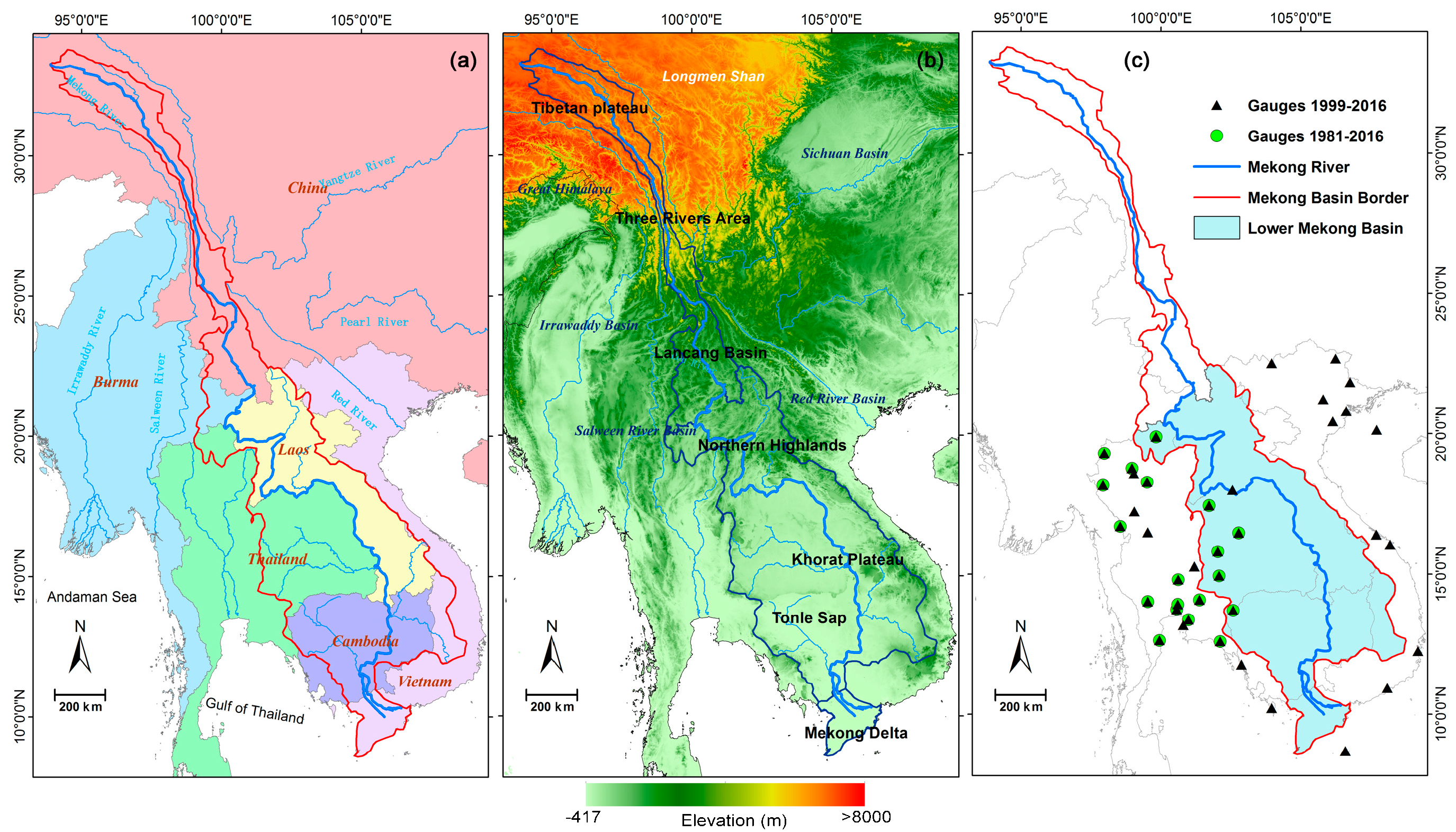
2.1. Study Area
2.2. Datasets
2.2.1. The Observed Precipitation Gauge
2.2.2. CHIRPS Satellite Precipitation Dataset
2.2.3. AVHRR Vegetation Health Product
2.2.4. Soil Moisture Dataset
2.3. Methods
2.3.1. Statistical Evaluation Metrics
2.3.2. The Standardized Precipitation Index (SPI)
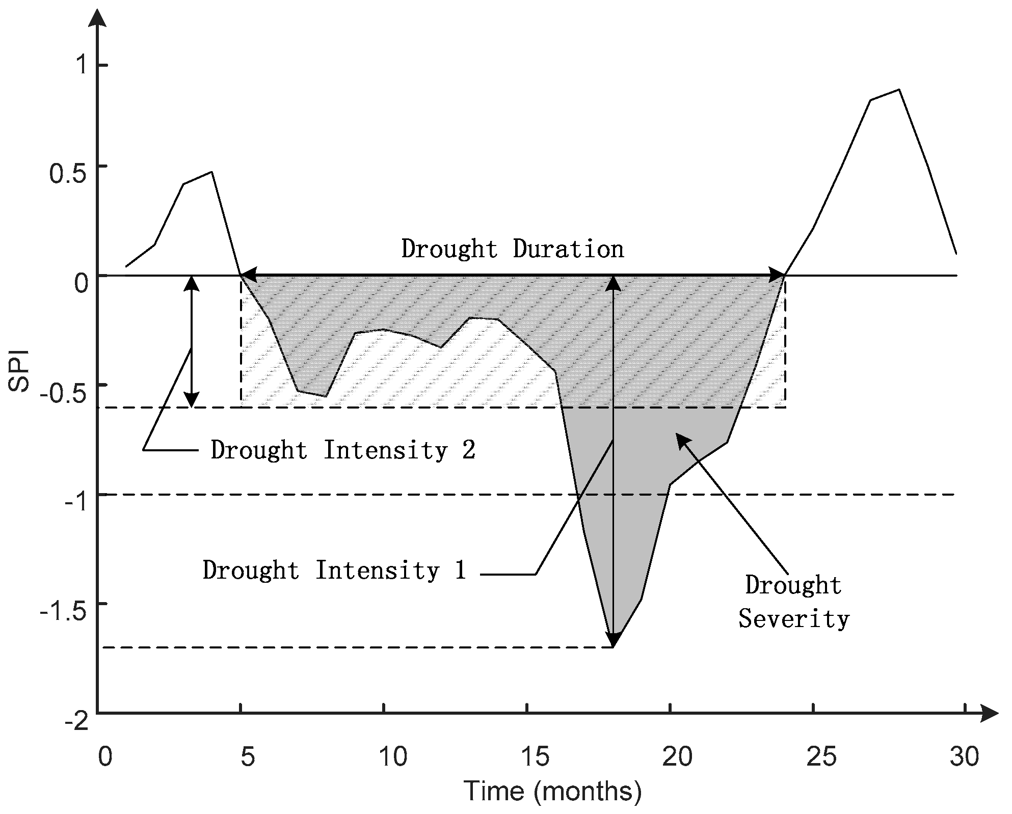
2.3.3. Drought Identification and Characteristics
3. Results
3.1. Evaluation of CHIRPS Using Rain Gauges
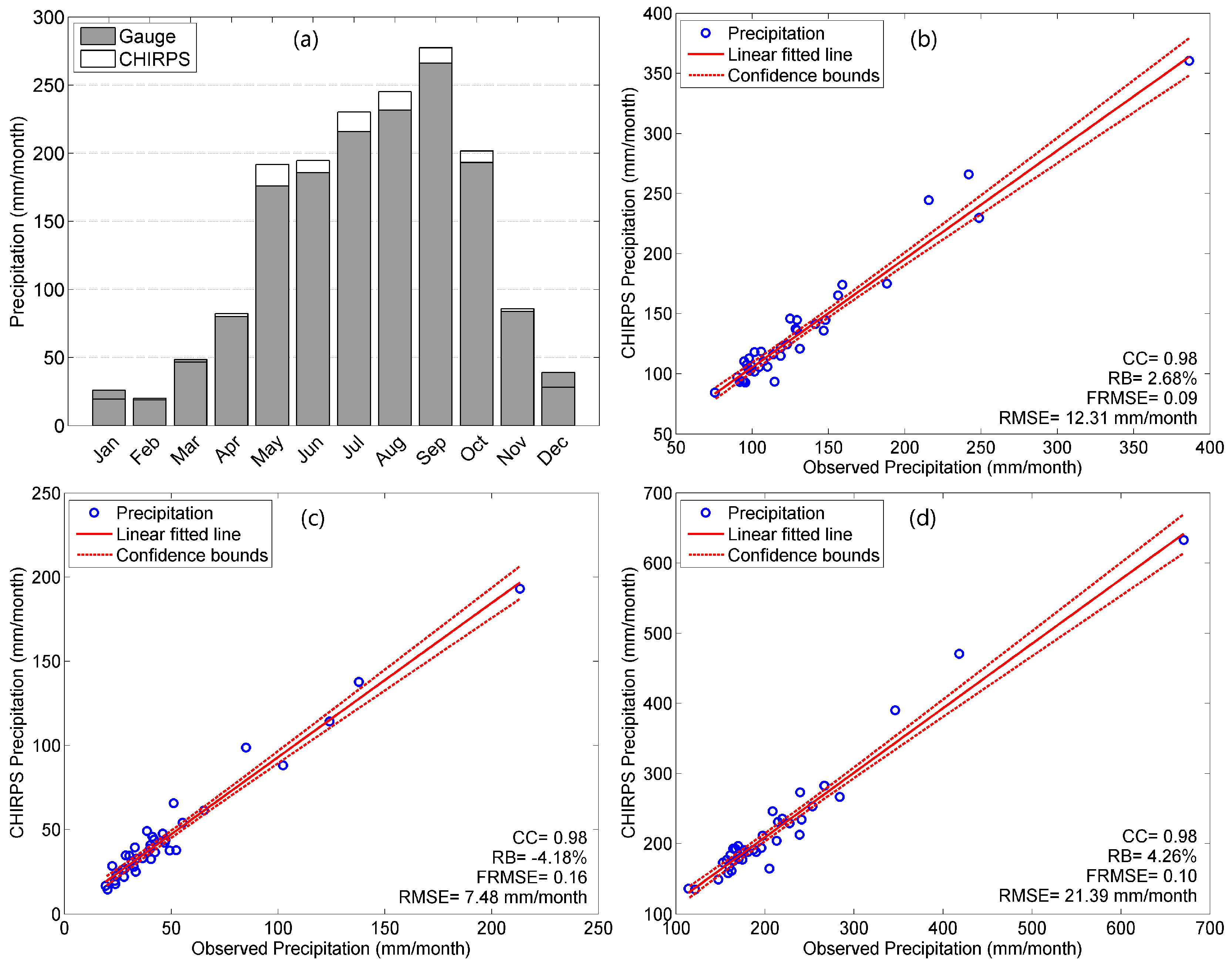
3.1.1. Precipitation Comparison
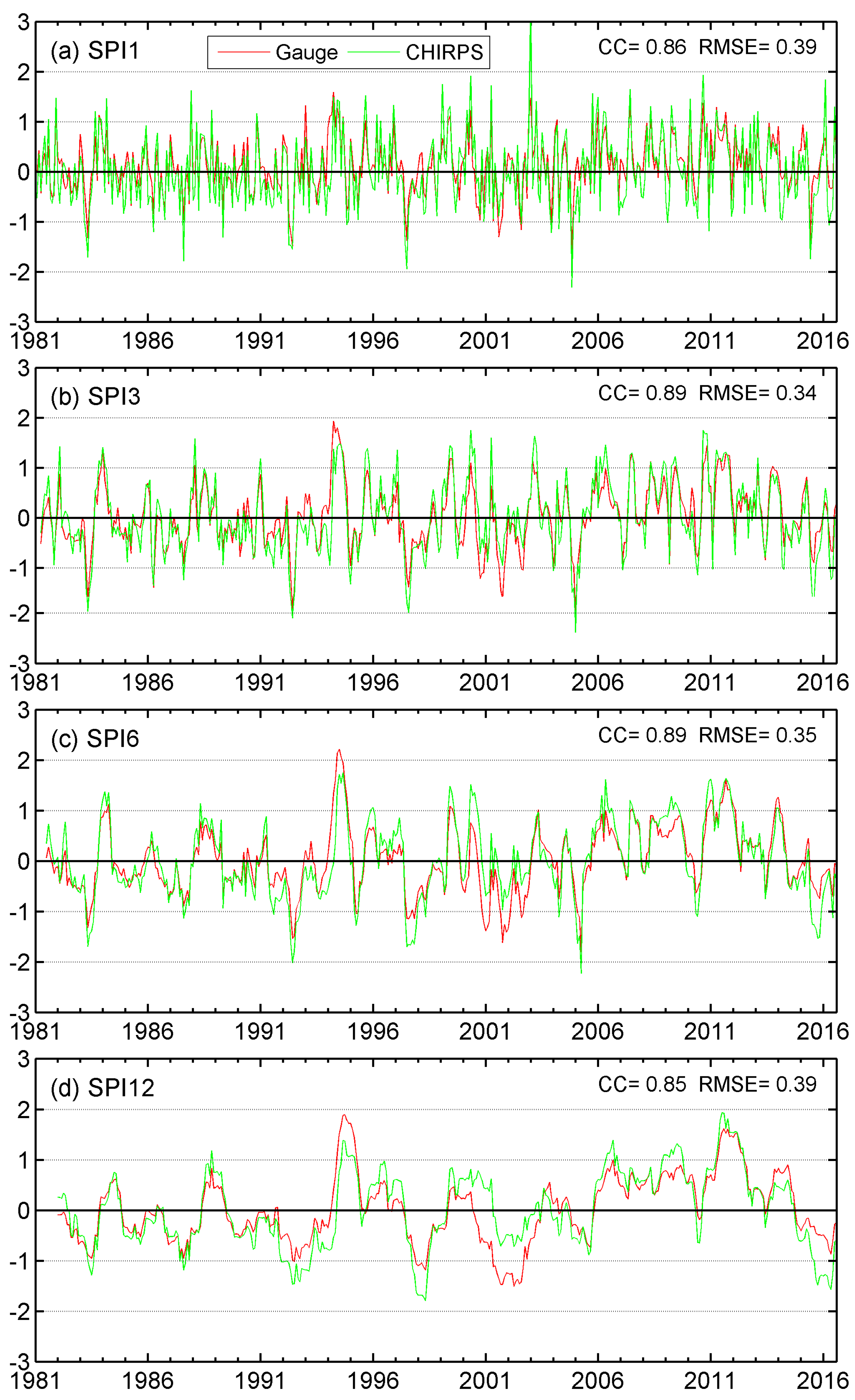
3.1.2. SPI Comparison
3.1.3. Cross Validation of CHIRPS
3.2. Drought Monitoring Based on CHIRPS
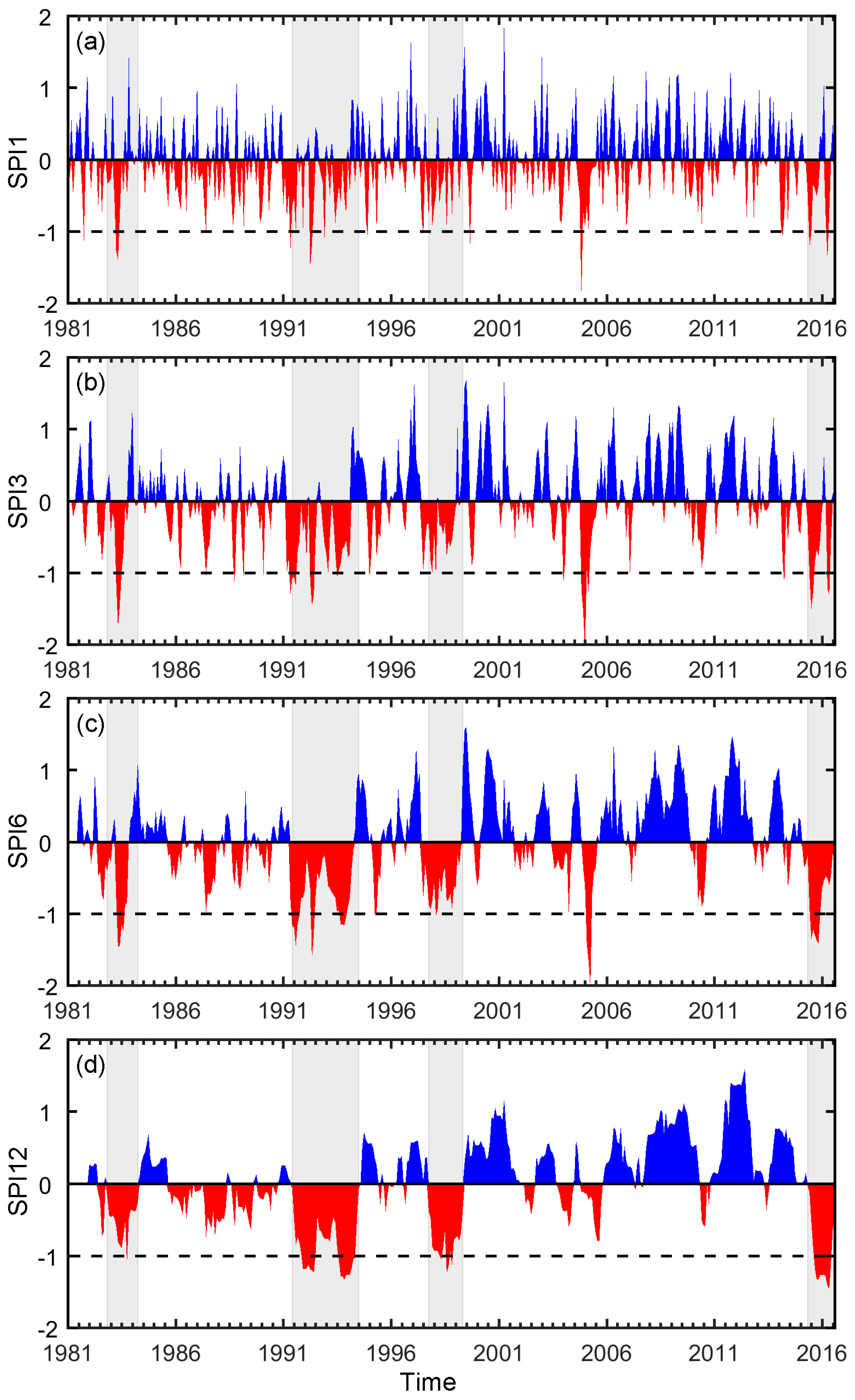
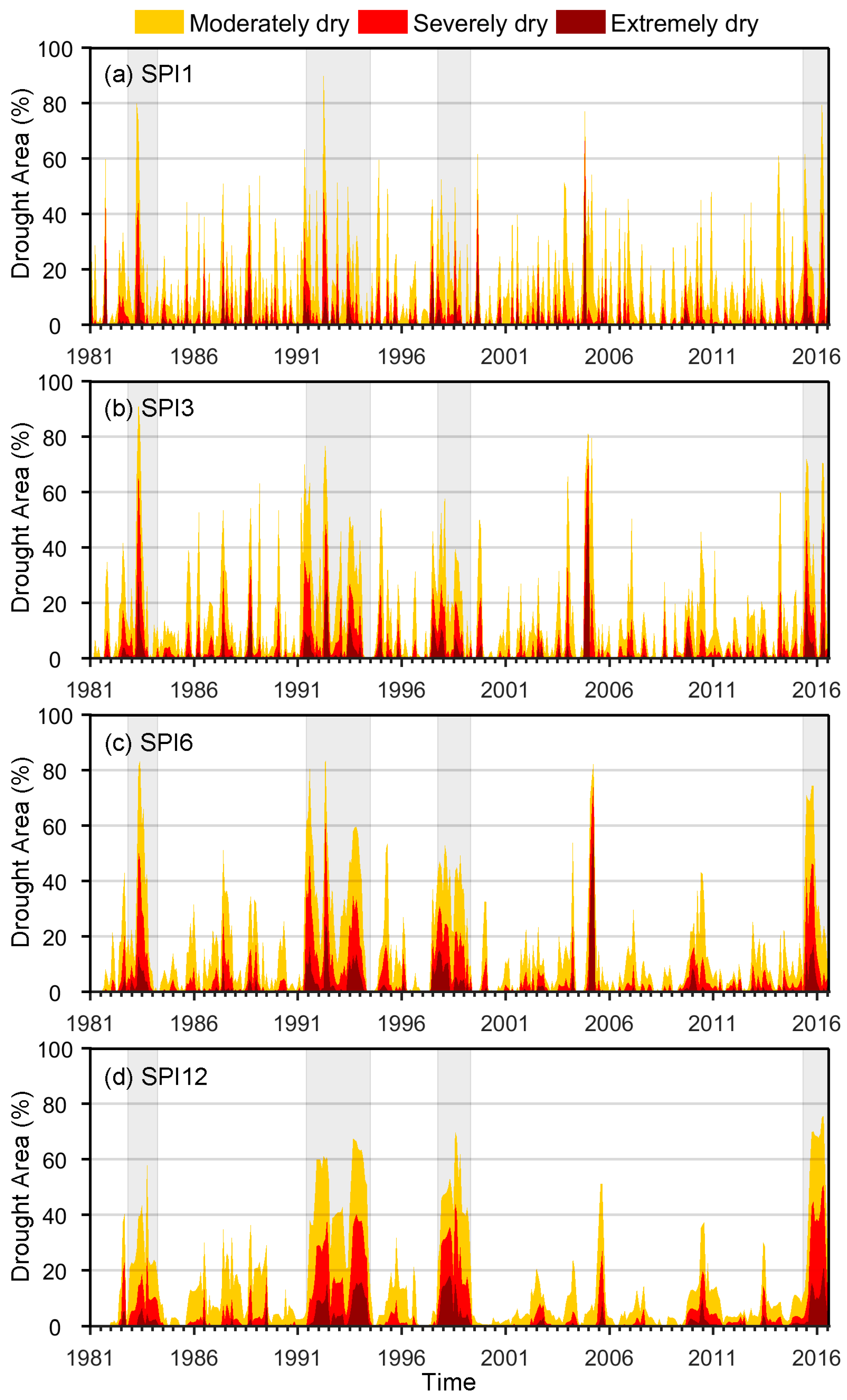
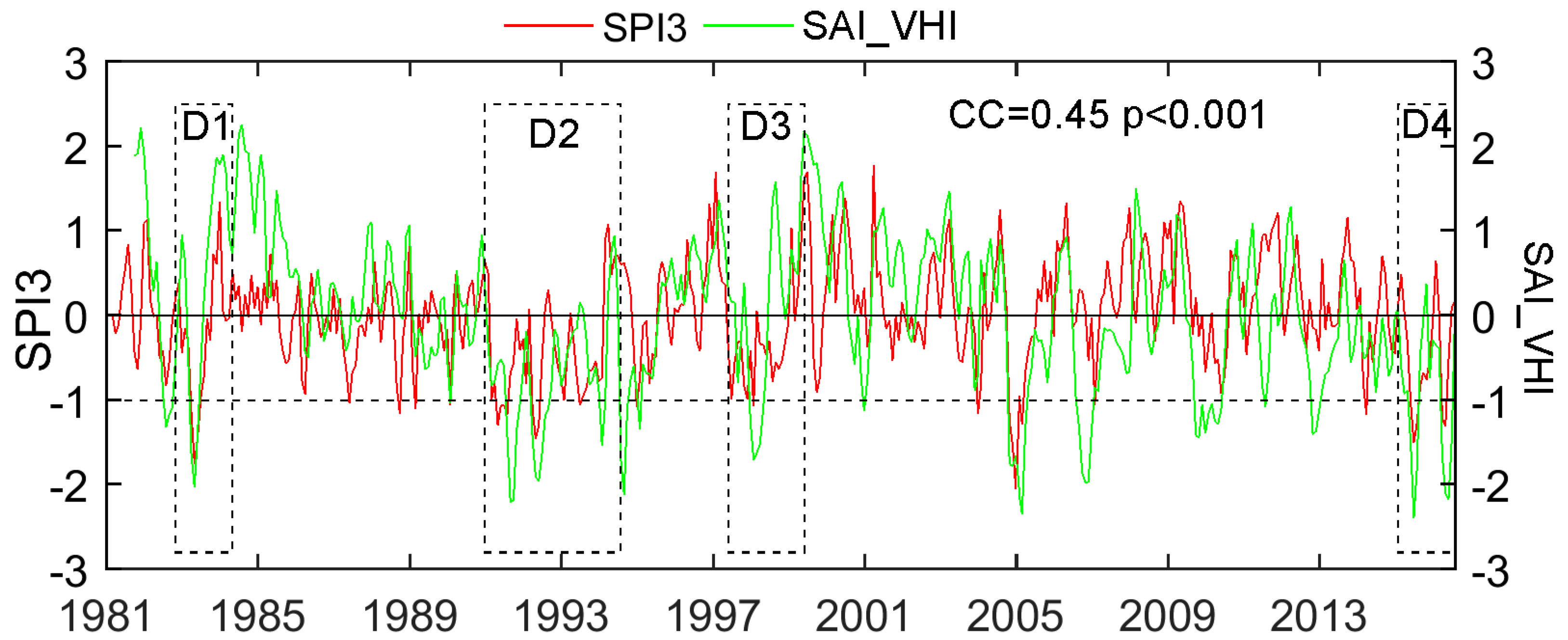
3.2.1. Temporal Analysis
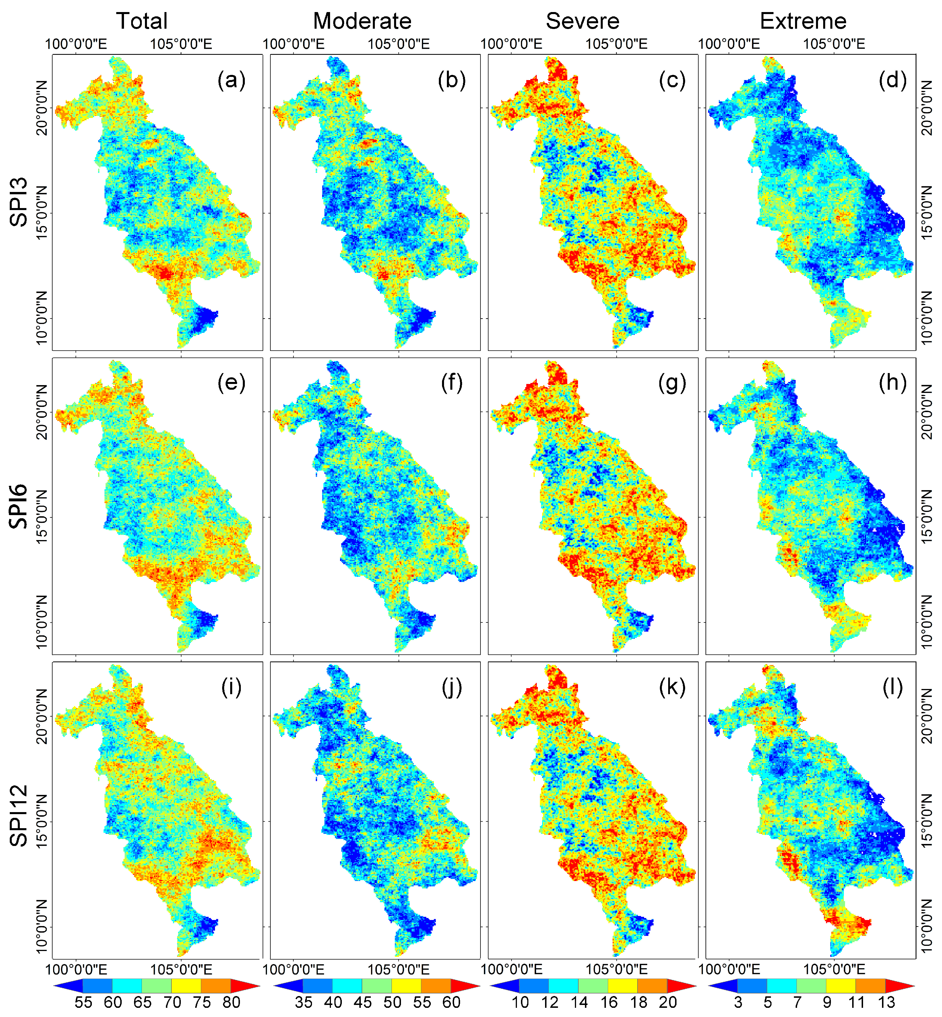
3.2.2. Total Drought Duration Analysis
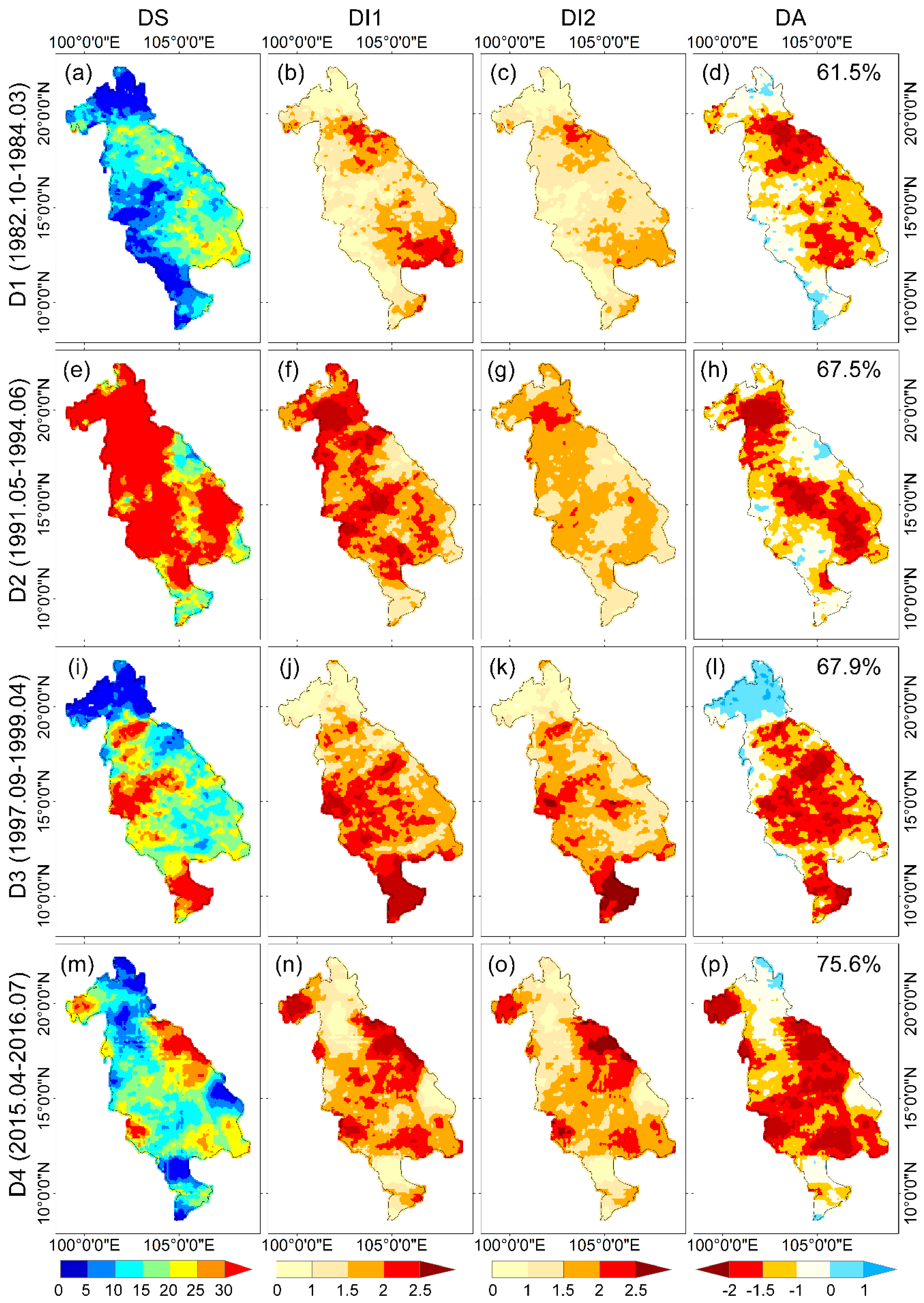
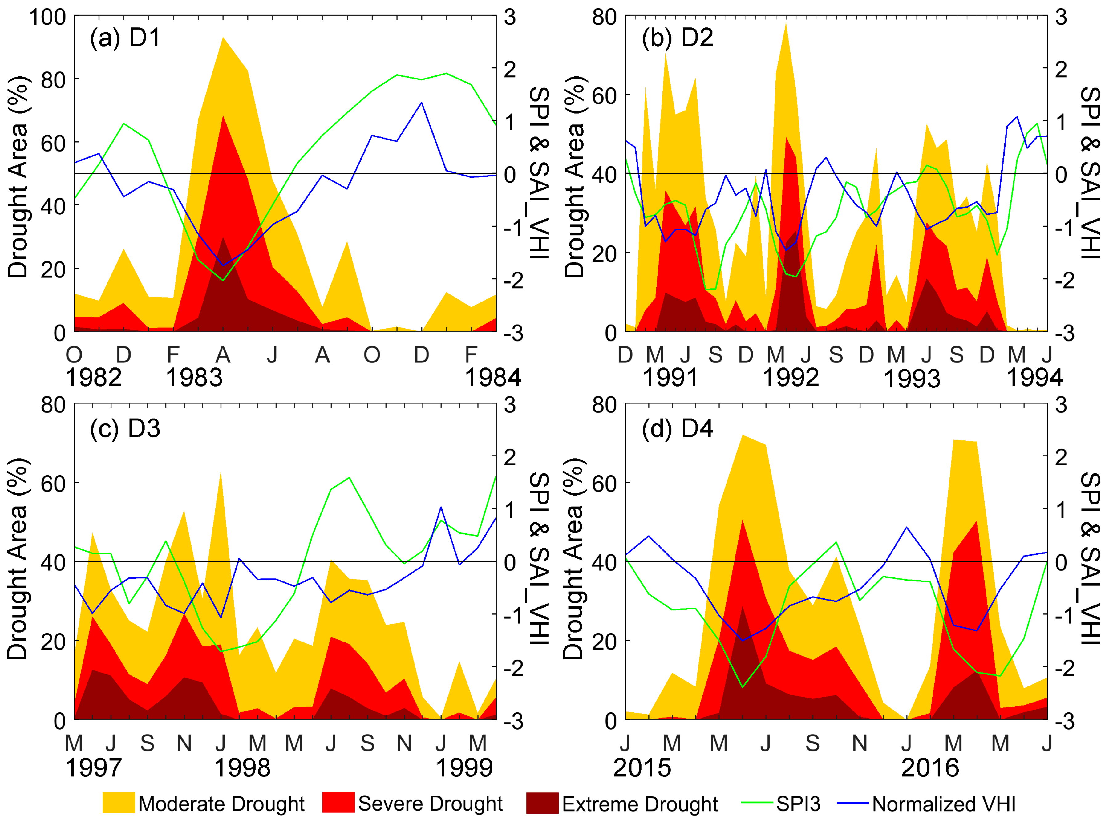
3.2.3. Specific Drought Events Analysis
3.3. Drought Impacts on Vegetation
4. Conclusions
- (1)
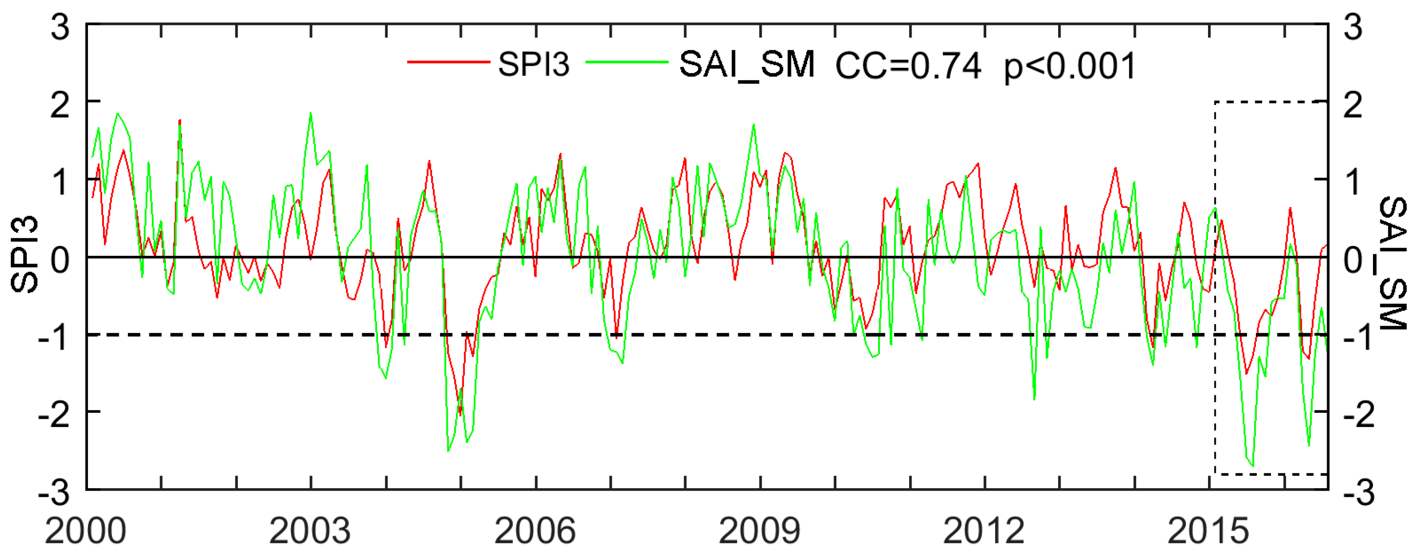
- CHIRPS shows reasonable ability to identify and characterize drought events. In comparison to rain gauges, CHIRPS performs well in estimating both monthly precipitation with high CC (0.98) and low RMSE (<13 mm/month) and SPI at different timescales. The results of three-month SPI (SPI3) have the best agreements while the relatively worse performance was detected at 12-month (SPI12) with slight overestimation in comparison with gauges. The SPI values at three-month timescale also exhibit high consistency with the variation of SAI_SM for the drought evolution.
- (2)
- In the period of January 1981–July 2016, LMB experienced several severe drought events such as November 1982–February 1984, June 1991–May 1994, September 1997–April 1999, and April 2015—July 2016. The drought event from May 1991 to June 1994 is found as the longest one with drought duration of 38 months, and the drought of 2015–2016 is the most intense one with the lowest SPI value (−1.45), the highest averaged drought severity (0.97) and the largest drought affected area (75.6%).
- (3)
- The total drought duration analysis further reveals that droughts occurred more frequently in the northern and southern LMB. Southwestern part of LMB and Mekong Delta region are more susceptible to severe drought events with long-term durations.
- (4)
- The comparison between SAI_VHI and SPI3 shows that vegetation health is greatly influenced by droughts in LMB.
Acknowledgments
Author Contributions
Conflicts of Interest
References
- Wilhite, D.A. Drought as a natural hazard: Concepts and definitions. Drought A Glob. Assess. 2000, 1, 3–18. [Google Scholar]
- Heim, R.R. A review of twentieth-century drought indices used in the united states. Bull. Am. Meteorol. Soc. 2002, 83, 1149–1165. [Google Scholar]
- Kao, S.C.; Govindaraju, R.S. A copula-based joint deficit index for droughts. J. Hydrol. 2010, 380, 121–134. [Google Scholar] [CrossRef]
- Keyantash, J.; Dracup, J.A. The quantification of drought: An evaluation of drought indices. Bull. Am. Meteorol. Soc. 2002, 83, 1167–1180. [Google Scholar]
- Adamson, P.; Bird, J. The mekong: A drought-prone tropical environment? Water Resour. Dev. 2010, 26, 579–594. [Google Scholar] [CrossRef]
- McKee, T.B.; Doesken, N.J.; Kleist, J. The relationship of drought frequency and duration to time scales. In Proceedings of the Eighth Conference on Applied Climatology, Anaheim, CA, USA, 17–22 January 1993. [Google Scholar]
- Edwards, D.C. Characteristics of 20th Century Drought in the United States at Multiple Time Scales; DTIC Document; Colorado State University: Fort Collins, CO, USA, 1997; No. 634. [Google Scholar]
- Hayes, M.; Svoboda, M.; Wall, N.; Widhalm, M. The lincoln declaration on drought indices: Universal meteorological drought index recommended. Bull. Am. Meteorol. Soc. 2011, 92, 485–488. [Google Scholar] [CrossRef]
- Seiler, R.A.; Hayes, M.; Bressan, L. Using the standardized precipitation index for flood risk monitoring. Int. J. Climatol. 2002, 22, 1365–1376. [Google Scholar] [CrossRef]
- Lu, E. Determining the start, duration, and strength of flood and drought with daily precipitation: Rationale. Geophys. Res. Lett. 2009, 36, L12707. [Google Scholar] [CrossRef]
- Hao, Z.; AghaKouchak, A. A nonparametric multivariate multi-index drought monitoring framework. J. Hydrometeorol. 2014, 15, 89–101. [Google Scholar] [CrossRef]
- Cancelliere, A.; Di Mauro, G.; Bonaccorso, B.; Rossi, G. Drought forecasting using the standardized precipitation index. Water Resour. Manag. 2007, 21, 801–819. [Google Scholar] [CrossRef]
- Thomas, T.; Nayak, P.C.; Ghosh, N.C. Spatiotemporal analysis of drought characteristics in the bundelkhand region of central india using the standardized precipitation index. J. Hydrol. Eng. 2015, 20, 05015004. [Google Scholar] [CrossRef]
- Joshi, N.; Gupta, D.; Suryavanshi, S.; Adamowski, J.; Madramootoo, C.A. Analysis of trends and dominant periodicities in drought variables in india: A wavelet transform based approach. Atmos. Res. 2016, 182, 200–220. [Google Scholar] [CrossRef]
- De Jesús, A.; Breña-Naranjo, J.A.; Pedrozo-Acuña, A.; Alcocer Yamanaka, V.H. The use of trmm 3b42 product for drought monitoring in mexico. Water 2016, 8, 325. [Google Scholar] [CrossRef]
- He, Y.; Ye, J.Y.; Yang, X.Y. Analysis of the spatio-temporal patterns of dry and wet conditions in the huai river basin using the standardized precipitation index. Atmos. Res. 2015, 166, 120–128. [Google Scholar] [CrossRef]
- Guo, H.; Bao, A.M.; Liu, T.; Chen, S.; Ndayisaba, F. Evaluation of persiann-cdr for meteorological drought monitoring over china. Remote Sens. 2016, 8, 379. [Google Scholar] [CrossRef]
- Lloyd-Hughes, B.; Saunders, M.A. A drought climatology for europe. Int. J. Climatol. 2002, 22, 1571–1592. [Google Scholar] [CrossRef]
- Miao, C.Y.; Ashouri, H.; Hsu, K.L.; Sorooshian, S.; Duan, Q.Y. Evaluation of the persiann-cdr daily rainfall estimates in capturing the behavior of extreme precipitation events over china. J. Hydrometeorol. 2015, 16, 1387–1396. [Google Scholar] [CrossRef]
- Kaptue, A.T.; Hanan, N.P.; Prihodko, L.; Ramirez, J.A. Spatial and temporal characteristics of rainfall in africa: Summary statistics for temporal downscaling. Water Resour. Res. 2015, 51, 2668–2679. [Google Scholar] [CrossRef]
- Naumann, G.; Barbosa, P.; Carrao, H.; Singleton, A.; Vogt, J. Monitoring drought conditions and their uncertainties in africa using trmm data. J. Appl. Meteorol. Climatol. 2012, 51, 1867–1874. [Google Scholar] [CrossRef]
- Huffman, G.J.; Adler, R.F.; Bolvin, D.T.; Gu, G.J.; Nelkin, E.J.; Bowman, K.P.; Hong, Y.; Stocker, E.F.; Wolff, D.B. The trmm multisatellite precipitation analysis (tmpa): Quasi-global, multiyear, combined-sensor precipitation estimates at fine scales. J. Hydrometeorol. 2007, 8, 38–55. [Google Scholar] [CrossRef]
- Joyce, R.J.; Janowiak, J.E.; Arkin, P.A.; Xie, P.P. Cmorph: A method that produces global precipitation estimates from passive microwave and infrared data at high spatial and temporal resolution. J. Hydrometeorol. 2004, 5, 487–503. [Google Scholar] [CrossRef]
- Ushio, T.; Sasashige, K.; Kubota, T.; Shige, S.; Okamoto, K.; Aonashi, K.; Inoue, T.; Takahashi, N.; Iguchi, T.; Kachi, M.; et al. A kalman filter approach to the global satellite mapping of precipitation (gsmap) from combined passive microwave and infrared radiometric data. J. Meteorol. Soc. Jpn. 2009, 87, 137–151. [Google Scholar] [CrossRef]
- Turk, J.; Mostovoy, G.; Anantharaj, V. The nrl-blend high resolution precipitation product and its application to land surface hydrology. In Satellite Rainfall Applications for Surface Hydrology; Gebremichael, M., Hossain, F., Eds.; Springer: Dordrecht, The Netherlands, 2010; pp. 85–104. [Google Scholar]
- Hsu, K.L.; Gao, X.G.; Sorooshian, S.; Gupta, H.V. Precipitation estimation from remotely sensed information using artificial neural networks. J. Appl. Meteorol. 1997, 36, 1176–1190. [Google Scholar] [CrossRef]
- Sorooshian, S.; Hsu, K.-L.; Gao, X.; Gupta, H.V.; Imam, B.; Braithwaite, D. Evaluation of persiann system satellite–based estimates of tropical rainfall. Bull. Am. Meteorol. Soc. 2000, 81, 2035–2046. [Google Scholar] [CrossRef]
- Yong, B.; Chen, B.; Gourley, J.J.; Ren, L.; Hong, Y.; Chen, X.; Wang, W.; Chen, S.; Gong, L. Intercomparison of the version-6 and version-7 tmpa precipitation products over high and low latitudes basins with independent gauge networks: Is the newer version better in both real-time and post-real-time analysis for water resources and hydrologic extremes? J. Hydrol. 2014, 508, 77–87. [Google Scholar]
- Xue, X.; Hong, Y.; Limaye, A.S.; Gourley, J.J.; Huffman, G.J.; Khan, S.I.; Dorji, C.; Chen, S. Statistical and hydrological evaluation of trmm-based multi-satellite precipitation analysis over the wangchu basin of bhutan: Are the latest satellite precipitation products 3b42v7 ready for use in ungauged basins? J. Hydrol. 2013, 499, 91–99. [Google Scholar] [CrossRef]
- Stisen, S.; Sandholt, I. Evaluation of remote-sensing-based rainfall products through predictive capability in hydrological runoff modelling. Hydrol. Process. 2010, 24, 879–891. [Google Scholar] [CrossRef]
- Tan, M.; Tan, K.; Chua, V.; Chan, N. Evaluation of trmm product for monitoring drought in the kelantan river basin, malaysia. Water 2017, 9, 57. [Google Scholar] [CrossRef]
- Tao, H.; Fischer, T.; Zeng, Y.; Fraedrich, K. Evaluation of trmm 3b43 precipitation data for drought monitoring in jiangsu province, china. Water 2016, 8, 221. [Google Scholar] [CrossRef]
- Burroughs, W. Climate: Into the 21st Century; Cambridge University Press: Cambridge, UK, 2003. [Google Scholar]
- WMO. Standardized precipitation index user guide. In WMO-No. 1090; Svoboda, M., Ed.; WMO: Geneva, Switzerland, 2012. [Google Scholar]
- Ashouri, H.; Hsu, K.L.; Sorooshian, S.; Braithwaite, D.K.; Knapp, K.R.; Cecil, L.D.; Nelson, B.R.; Prat, O.P. Persiann-cdr daily precipitation climate data record from multisatellite observations for hydrological and climate studies. Bull. Am. Meteorol. Soc. 2015, 96, 69–83. [Google Scholar] [CrossRef]
- Funk, C.C.; Peterson, P.J.; Landsfeld, M.F.; Pedreros, D.H.; Verdin, J.P.; Rowland, J.D.; Romero, B.E.; Husak, G.J.; Michaelsen, J.C.; Verdin, A.P. A quasi-global precipitation time series for drought monitoring. U.S. Geol. Surv. Data Ser. 2014, 832. [Google Scholar]
- Katsanos, D.; Retalis, A.; Michaelides, S. Validation of a high-resolution precipitation database (chirps) over cyprus for a 30-year period. Atmos. Res. 2016, 169, 459–464. [Google Scholar] [CrossRef]
- Katsanos, D.; Retalis, A.; Tymvios, F.; Michaelides, S. Analysis of precipitation extremes based on satellite (chirps) and in situ dataset over cyprus. Nat. Hazards 2016, 83, 53–63. [Google Scholar] [CrossRef]
- Tuo, Y.; Duan, Z.; Disse, M.; Chiogna, G. Evaluation of precipitation input for swat modeling in alpine catchment: A case study in the adige river basin (Italy). Sci. Total Environ. 2016, 573, 66–82. [Google Scholar] [CrossRef] [PubMed]
- Zambrano, F.; Wardlow, B.; Tadesse, T.; Lillo-Saavedra, M.; Lagos, O. Evaluating satellite-derived long-term historical precipitation datasets for drought monitoring in chile. Atmos. Res. 2017, 186, 26–42. [Google Scholar] [CrossRef]
- Hoang, L.; Lauri, H.; Kummu, M.; Koponen, J.; van Vliet, M.; Supit, I.; Leemans, R.; Kabat, P.; Ludwig, F. Mekong river flow and hydrological extremes under climate change. Hydrol. Earth Syst. Sci. 2015, 12, 11651–11687. [Google Scholar] [CrossRef]
- Son, N.T.; Chen, C.F.; Chen, C.R.; Chang, L.Y.; Minh, V.Q. Monitoring agricultural drought in the lower mekong basin using modis ndvi and land surface temperature data. Int. J. Appl. Earth Obs. 2012, 18, 417–427. [Google Scholar] [CrossRef]
- Zhang, B.H.; Zhang, L.; Guo, H.D.; Leinenkugel, P.; Zhou, Y.; Li, L.; Shen, Q. Drought impact on vegetation productivity in the lower mekong basin. Int. J. Remote Sens. 2014, 35, 2835–2856. [Google Scholar] [CrossRef]
- Hundertmark, W. Building drought management capacity in the mekong river basin. Irrig. Drain. 2008, 57, 279–287. [Google Scholar] [CrossRef]
- Gupta, A.; Liew, S.C. The mekong from satellite imagery: A quick look at a large river. Geomorphology 2007, 85, 259–274. [Google Scholar] [CrossRef]
- Leinenkugel, P.; Kuenzer, C.; Dech, S. Comparison and enhancement of modis cloud mask products for southeast asia. Int. J. Remote Sens. 2013, 34, 2730–2748. [Google Scholar] [CrossRef]
- National Climatic Data Center; National Oceanic and Atmospheric Administration. Department of Commerce Global Surface Summary of the Day; GSOD National Climatic Data Center: Asheville, NC, USA, 2011.
- Rizzoli, A.; Hauffe, H.C.; Tagliapietra, V.; Neteler, M.; Rosa, R. Forest structure and roe deer abundance predict tick-borne encephalitis risk in italy. PLoS ONE 2009, 4, e4336. [Google Scholar] [CrossRef] [PubMed]
- Dingman, S.L. Normal radio method. In Physical Hydrology; Waveland Press: Long Grove, IL, USA, 2015; p. 115. [Google Scholar]
- Funk, C.; Peterson, P.; Landsfeld, M.; Pedreros, D.; Verdin, J.; Shukla, S.; Husak, G.; Rowland, J.; Harrison, L.; Hoell, A.; et al. The climate hazards infrared precipitation with stations—A new environmental record for monitoring extremes. Sci. Data 2015, 2, 150066. [Google Scholar] [CrossRef] [PubMed]
- NOAA. Avhrr Vegetation Health Product. Available online: https://www.star.nesdis.noaa.gov/smcd/emb/vci/VH/vh_ftp.php (accessed on 20 September 2016).
- Bokusheva, R.; Kogan, F.; Vitkovskaya, I.; Conradt, S.; Batyrbayeva, M. Satellite-based vegetation health indices as a criteria for insuring against drought-related yield losses. Agric. For. Meteorol. 2016, 220, 200–206. [Google Scholar] [CrossRef]
- Sholihah, R.I.; Trisasongko, B.H.; Shiddiq, D.; Iman, L.O.S.; Kusdaryanto, S.; Manijo; Panuju, D.R. Identification of agricultural drought extent based on vegetation health indices of landsat data: Case of subang and karawang, indonesia. Proced. Environ. Sci. 2016, 33, 14–20. [Google Scholar] [CrossRef]
- Kogan, F.; Salazar, L.; Roytman, L. Forecasting crop production using satellite-based vegetation health indices in kansas, USA. Int. J. Remote Sens. 2012, 33, 2798–2814. [Google Scholar] [CrossRef]
- Choi, M.; Jacobs, J.M.; Anderson, M.C.; Bosch, D.D. Evaluation of drought indices via remotely sensed data with hydrological variables. J. Hydrol. 2013, 476, 265–273. [Google Scholar] [CrossRef]
- Mukherjee, T.; Mukherjee, S.; Mukhopadhaya, A.; Roy, A.K.; Dutta, S. Drought monitoring of chhattisgarh using different indices based on remote sensing data. In Climate Change and Biodiversity: Proceedings of IGU Rohtak Conference, Vol. 1; Singh, M., Singh, R.B., Hassan, M.I., Eds.; Springer: Tokyo, Japan, 2014; pp. 85–101. [Google Scholar]
- DISC, G. Goddard Earth Sciences Data and Information Services Center. Available online: https://disc.sci.gsfc.nasa.gov (accessed on 21 September 2016).
- Bordi, I.; Sutera, A. Drought monitoring and forecasting at large scale. In Methods and Tools for Drought Analysis and Management; Rossi, G., Vega, T., Bonaccorso, B., Eds.; Springer: Dordrecht, The Netherlands, 2007; Volume 62, pp. 3–27. [Google Scholar]
- Sternberg, T.; Thomas, D.; Middleton, N. Drought dynamics on the mongolian steppe, 1970–2006. Int. J. Climatol. 2011, 31, 1823–1830. [Google Scholar] [CrossRef]
- Ashraf, M.; Routray, J.K. Spatio-temporal characteristics of precipitation and drought in balochistan province, pakistan. Nat. Hazards 2015, 77, 229–254. [Google Scholar] [CrossRef]
- Program to Calculate Standardized Precipitation Index. Available online: http://drought.unl.edu/MonitoringTools/DownloadableSPIProgram.aspx (accessed on 21 September 2016).
- Yevjevich, V.M. An Objective Approach to Definitions and Investigations of Continental Hydrologic Droughts; Hydrology Papers; Colorado State University: Fort Collins, CO, USA, 1967. [Google Scholar]
- Spinoni, J.; Naumann, G.; Carrao, H.; Barbosa, P.; Vogt, J. World drought frequency, duration, and severity for 1951–2010. Int. J. Climatol. 2014, 34, 2792–2804. [Google Scholar] [CrossRef]
- Tan, C.; Yang, J.; Li, M. Temporal-spatial variation of drought indicated by spi and spei in ningxia hui autonomous region, china. Atmosphere 2015, 6, 1399–1421. [Google Scholar] [CrossRef]
- Guo, H.; Chen, S.; Bao, A.M.; Hu, J.J.; Gebregiorgis, A.S.; Xue, X.W.; Zhang, X.H. Inter-comparison of high-resolution satellite precipitation products over central asia. Remote Sens. 2015, 7, 7181–7211. [Google Scholar] [CrossRef]
- Tian, Y.D.; Peters-Lidard, C.D.; Choudhury, B.J.; Garcia, M. Multitemporal analysis of trmm-based satellite precipitation products for land data assimilation applications. J. Hydrometeorol. 2007, 8, 1165–1183. [Google Scholar] [CrossRef]
- Sonmez, F.K.; Komuscu, A.U.; Erkan, A.; Turgu, E. An analysis of spatial and temporal dimension of drought vulnerability in turkey using the standardized precipitation index. Nat. Hazards 2005, 35, 243–264. [Google Scholar] [CrossRef]
- Andreadis, K.M.; Clark, E.A.; Wood, A.W.; Hamlet, A.F.; Lettenmaier, D.P. Twentieth-century drought in the conterminous united states. J. Hydrometeorol. 2005, 6, 985–1001. [Google Scholar] [CrossRef]


| Statistical Metric | Equation | Optimal Value |
|---|---|---|
| Relative Bias (RB) 1 | 0 | |
| Pearson linear correlation coefficient (CC) 1 | 1 | |
| Root Mean Square Error (RMSE) 1 | 0 | |
| Fractional RMSE (FRMSE) 1 | 0 |
| SPI Value | Category |
|---|---|
| 2.0 and above | Extremely wet |
| 1.5 to 1.99 | Severely wet |
| 1.0 to 1.49 | Moderately wet |
| −0.99 to 0.99 | Near normal |
| −1.0 to −1.49 | Moderately dry |
| −1.5 to −1.99 | Severely dry |
| −2.0 and less | Extremely dry |
| Index | Start-End | DD | DS | DI1 | DI2 | DA (%) |
|---|---|---|---|---|---|---|
| D1 | October 1982–March 1984 | 18 | 9.62 | 1.09 | 0.53 | 61.5 |
| D2 | May 1991–June 1994 | 38 | 33.61 | 1.33 | 0.88 | 67.5 |
| D3 | September 1997–April 1999 | 20 | 16.55 | 1.23 | 0.83 | 67.9 |
| D4 | April 2015–July 2016 | 16 | 15.50 | 1.45 | 0.97 | 75.6 |
© 2017 by the authors. Licensee MDPI, Basel, Switzerland. This article is an open access article distributed under the terms and conditions of the Creative Commons Attribution (CC BY) license (http://creativecommons.org/licenses/by/4.0/).
Share and Cite
Guo, H.; Bao, A.; Liu, T.; Ndayisaba, F.; He, D.; Kurban, A.; De Maeyer, P. Meteorological Drought Analysis in the Lower Mekong Basin Using Satellite-Based Long-Term CHIRPS Product. Sustainability 2017, 9, 901. https://doi.org/10.3390/su9060901
Guo H, Bao A, Liu T, Ndayisaba F, He D, Kurban A, De Maeyer P. Meteorological Drought Analysis in the Lower Mekong Basin Using Satellite-Based Long-Term CHIRPS Product. Sustainability. 2017; 9(6):901. https://doi.org/10.3390/su9060901
Chicago/Turabian StyleGuo, Hao, Anming Bao, Tie Liu, Felix Ndayisaba, Daming He, Alishir Kurban, and Philippe De Maeyer. 2017. "Meteorological Drought Analysis in the Lower Mekong Basin Using Satellite-Based Long-Term CHIRPS Product" Sustainability 9, no. 6: 901. https://doi.org/10.3390/su9060901
APA StyleGuo, H., Bao, A., Liu, T., Ndayisaba, F., He, D., Kurban, A., & De Maeyer, P. (2017). Meteorological Drought Analysis in the Lower Mekong Basin Using Satellite-Based Long-Term CHIRPS Product. Sustainability, 9(6), 901. https://doi.org/10.3390/su9060901