1. Introduction
In the latter half of the 20th Century, a progressive decline in the overall health of downtown areas in North America has occurred [
1,
2]. There are numerous causes for this decline including but not limited to the decentralization of many traditional downtown functions to surrounding suburban areas and overall changes in the economic activity of a city or metropolitan area. With respect to the latter, larger cities in eastern North America have seen major declines in central cities or Central Business Districts (e.g., Detroit, Buffalo, Montreal) which can be attributed to declines in the manufacturing sector and coincidental rise of tertiary economic activities in the emerging high-tech economy and financial services industry [
3]. However, deindustrialization and the growth of new economic activities do not necessarily occur in the same city or region. For smaller cities, situated in the resource-rich hinterland areas of Canada or the United States, changes in technology and global markets have affected employment in traditional job-rich sectors such as forestry, mining, fishing and agriculture. Some of these communities are now faced with real population decline requiring municipal governments to adjust their traditional planning mindset focused on economic and population growth [
4]. With respect to the impact of suburbanization, residents began early in the 20th Century to migrate away from downtown areas [
5] and this migration and explosion of housing in suburban rings is well documented for cities of a variety of scales [
6]. Other traditional central city functions, such as commercial or retail activities followed in due course with the introduction of the regional shopping centre model in North America (in the 1960’s and 1970’s) and proliferation of the ‘Big Box’ retail sector since the late 1980s. Not all cities or metropolitan areas experienced these declines in their downtowns due to the combined effects of suburbanization and shifting economic functions. Examples such as New York or San Francisco in the United States and Toronto and Vancouver in Canada have, in general, maintained a healthy central city or downtown core even with substantial suburban growth, due to having enough overall investment and population growth [
7].
Municipal governments were very much aware of the decline of downtowns and have experimented with a variety of renewal and revitalization strategies over the past half-century to maintain their function and viability. Such downtown renewal strategies fall into one of three categories, according to [
6]: (1) adaptation for automobile accessibility; (2) head-on competition with suburbs, and (3) the accentuation of a distinct core area identity. The creation of downtown mall projects during the 1970s—probably the most well-known revitalization tool—is generally viewed as a failed attempt at revitalization, particularly in mid-sized cities [
8], as are projects which prioritized automobile access to the core over accommodation of pedestrians, as a means for downtowns to compete with suburban areas [
9]. More successful downtown renewal projects have been the creation of recreational facilities, stimulating residential (re-)occupancy in downtowns and construction of cultural facilities such as downtown sports arenas and convention centres [
10,
11]. An increasing area of urban renewal has been that of ‘waterfront renewal’, in which former industrial waterfront (or riverfronts) have been reclaimed and redeveloped as a means of city renewal [
12,
13]. As many of these waterfronts are adjacent to downtowns, they too provide significant potential to act as a catalyst of downtown revitalization.
2. Project Objectives and Study Area
This article presents a case study of the City of Thunder Bay’s recent history with revitalization and renewal. Thunder Bay is a small to medium-sized city with a metropolitan population of approximately 121,600 [
14], located in Northwestern Ontario. It has a total land area of 2556 km
2 and an average population density of 47.6 persons/km
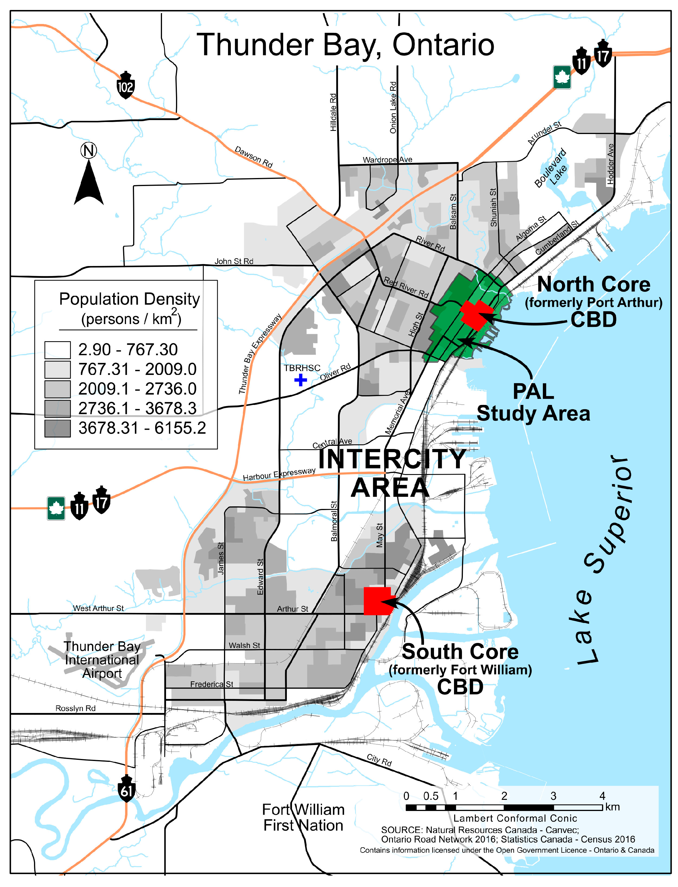
2. Thunder Bay was created in 1970 through the amalgamation of the two former cities of Port Arthur and Fort William, whose former Central Business Districts (CBDs) are now commonly referred to as the North Core and South Core, respectively (see
Figure 1). At the time of amalgamation in 1970, the combined city’s population was approximately 112,000 [
15] and was forecast to grow considerably. However, during the 1970s and continuing, Thunder Bay faced many of the same challenges as other urban centers in Canada and the U.S., such as urban sprawl, declining industrial activity, and the decay of downtown and inner city neighbourhoods. Unique to Thunder Bay is the existence of two struggling downtown cores (rather than one in most cities), amidst the backdrop of a loss of well-paying blue collar employment in the forestry and grain-handling sectors since the 1990s.
Recognizing the challenge of managing two downtown cores in difficult economic times (the two former cities are only approximately 7 km apart), the City opted to better differentiate the roles of the two former CBDs through a process of ‘urban specialization’; mentioned by [
6] as one of 3 categories of downtown renewal strategies. The North Core has been re-branded as the City’s ‘Entertainment District’ and, in addition to the location for the Waterfront renewal project, is home to a charity casino, Marina Park (which hosts several concerts and festivals annually), a playhouse, a growing diversity of bars and restaurants as well as other downtown functions like shopping and office employment. The South Core has been re-branded as the City’s ‘Business District’ and houses City Hall and most of the city departments and divisions (i.e., planning, engineering, parks, etc.), federal government regional offices, a newly constructed Provincial courthouse (in 2014), an aging but valued arena (Fort William Gardens) and other downtown functions. The area between the two cores is known as the ‘Intercity Area’ and has been the location for much of the suburban commercial and light industrial development seen in the City since 1970. Growth of the Intercity Area was meant to unite the two cities both politically and economically [
16,
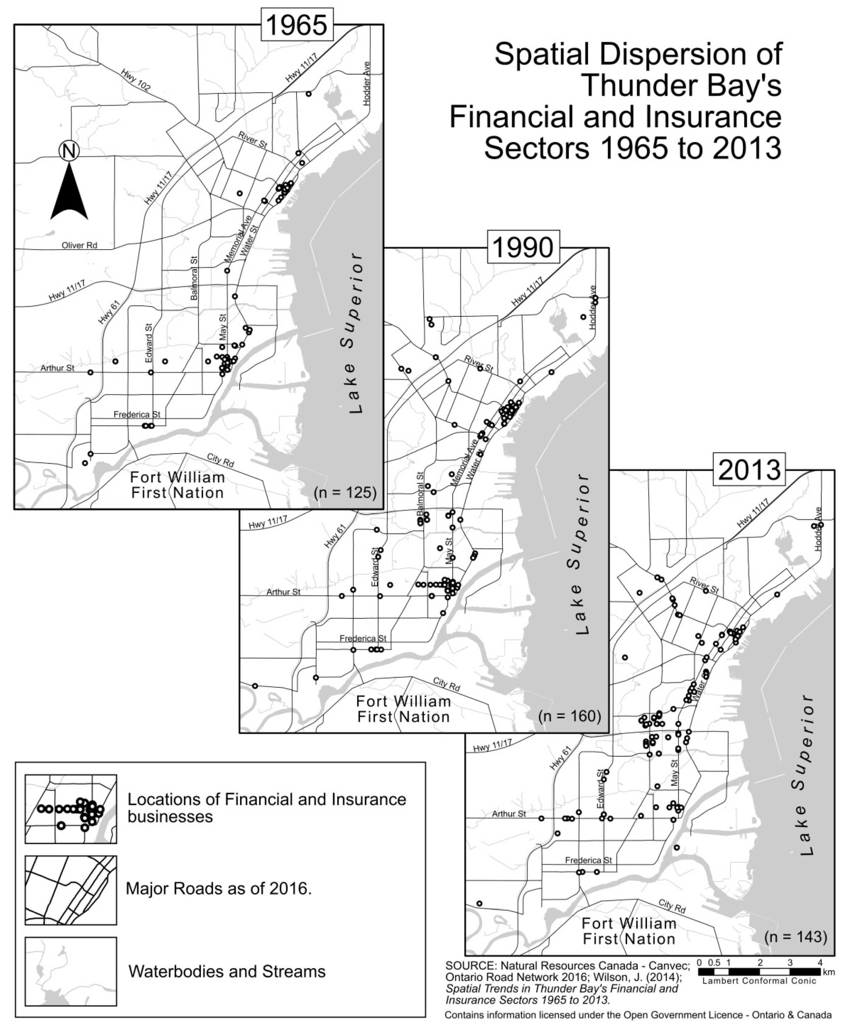
17]. Unfortunately, due to the above-mentioned economic challenges, investments in the Intercity—while practical in a spatial sense—have resulted in dis-investment in the older north and south cores. Two key sectors in which this trend has been noted are the insurance and financial sectors (see [
18]). Traditionally and in many current cities these are core employment sectors located within the downtown core. Wilson’s study in 2014 demonstrated a continued suburbanization of the insurance and financial services sectors to Thunder Bay’s Intercity area over the past half-century (
Figure 2). While these sectors were almost exclusively downtown in 1965 through to 1990 (e.g., 89% in North and South cores in 1965;
Table 1), slightly less than one-quarter of these functions are retained in the two downtowns as of 2013. This trend, like that observed in downtowns across North America further explains the downturn in the economic health and/or vibrancy of the two downtowns and challenges faced for revitalizing these areas.
It is important to acknowledge that downtown revitalization is not an attempt to return a city to the conditions of a previous period with a dominant downtown core. Rather, these are attempts to ‘modernize’ and ‘retool’ the downtown so it can remain an integral component of its overall metropolitan area in the context of more sustainable land use patterns in cities. Moreover, revitalization of downtown core areas should result in creating downtown environments that are enticing and walkable [
19]. There is an increasing number of innovative planning concepts aimed at creating more sustainable metropolitan areas [
20], including pedestrian-oriented and mixed-used development models of the New Urbanism [
21,
22], transit-oriented developments such as those now found in Portland and San Diego and other US cities [
23,
24,
25], and the suburban downtown and regional town centre models found in Toronto and Vancouver, respectively (as discussed in [
26,
27]). Such ‘new’ strategies are largely replicating earlier models of urban form in North America and borrow heavily from European examples [
28]. Whatever is planned and built in downtowns to achieve their revitalization, they are planned in the context of creating more sustainable communities in both the environmental and socio-economic interpretations of sustainability. In essence, good planning would result in greater vibrancy of core areas and be part of an integrated effort to lessen the overall negative effect of cities on the environment. Borrowing from Jane Jacobs’ concept of ‘exuberant diversity’ [
29], she wrote that four conditions are indispensable for a downtown core to be considered vibrant in the social and economic senses: (1) mixed primary uses; (2) small blocks; (3) aged buildings; and (4) concentration. Downtown cores are fortunate that they typically have both small blocks and aged buildings, something that is difficult to replicate in the postwar North American suburb. The other two conditions (mixed primary uses and concentration) are both core concepts of sustainable urban development in that residential neighbourhoods, downtown cores, suburban downtowns or even an ‘edge city’ (see [
30]) need a mix of primary uses—so that people are drawn to these locations at a variety of times during the day and week—and these activities (residential, commercial, etc.) need sufficient concentration to make them ‘work’. For example, there are density threshold requirements to sustain economically viable public transit [
31]. Similarly, school boards need a certain number of students within a school’s catchment zone to make its operation viable. Typical indicators of healthy and vibrant urban forms are therefore residential land-use metrics like density and dwelling type mix, and commercial measures such as business diversity, investment and business stability, which will be discussed later in the article.
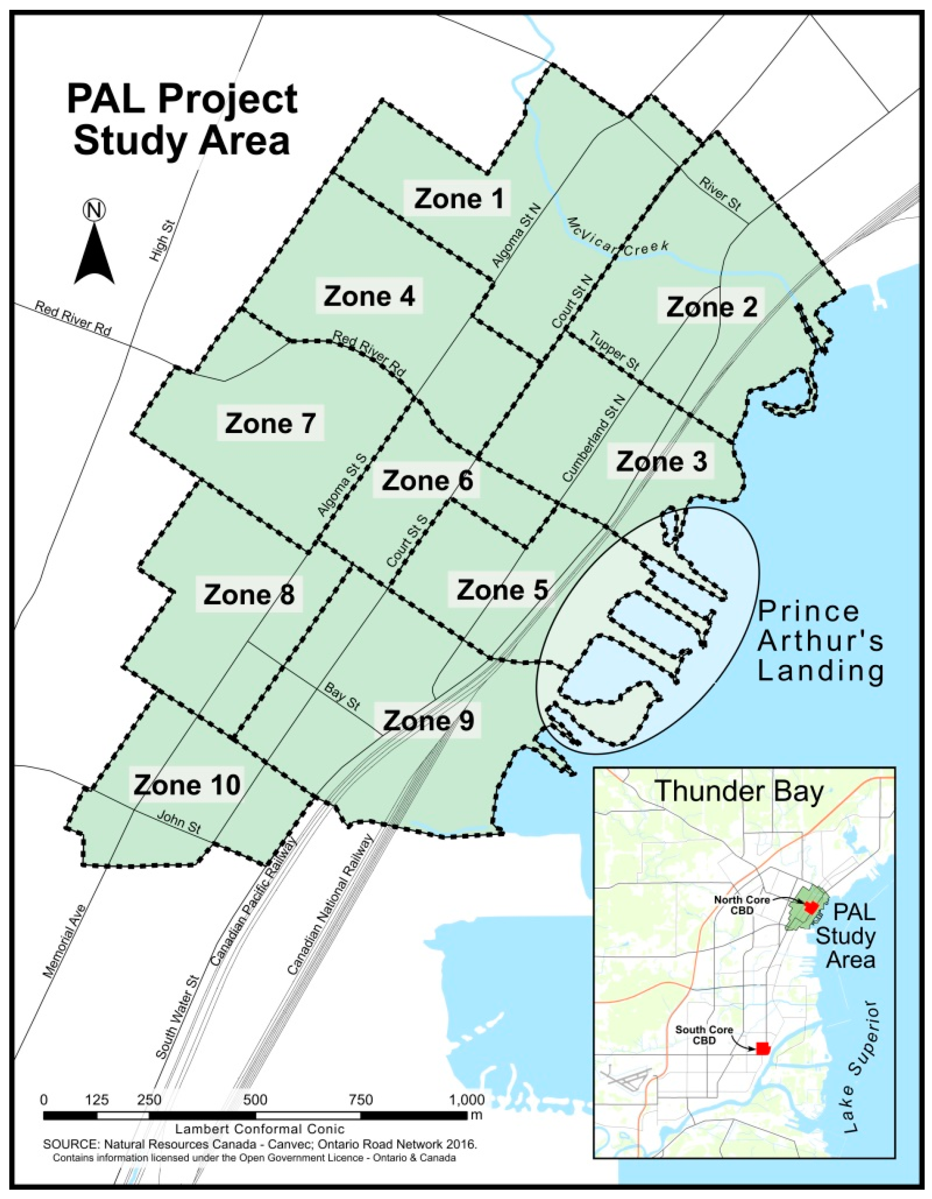
Revitalization efforts as a means to offset the economic decline of its downtown cores are not new to Thunder Bay. There have been a number of revitalization projects over the years including, but not limited to: the Keskus Mall (built: 1974; demolished: 1999) and Ontario Lottery and Gaming Corporation Charity Casino (opened: 2000) and the various efforts of the Waterfront District (The Waterfront District BIA is also known as the City’s Entertainment District (
http://www.lakesuperior.travel/TravelOntario/ThunderBay/WaterfrontBIA.aspx, accessed on 26 March 2017)) Business Improvement Area (BIA) committee. Since 2008, the City of Thunder Bay has been championing the redevelopment of a portion of the north core waterfront in the vicinity of the pre-existing Marina Park—an area known as Prince Arthur’s Landing (or PAL). The waterfront area at PAL, adjacent to the downtown North Core, has long been used for a variety of purposes including recreational use, for special events such as the City’s annual Blues Festival, as well as mooring for vessels and personal watercraft for tourists and local boaters. Marina Park was originally conceptualized within the 1967 Port Arthur Downtown Renewal Scheme (actual construction of the park was in 1979). While there were major investments in the downtown North Core prior to 2008, the major capital investments by the City and the private sector in Phase I of the waterfront project beginning in 2009 do appear to have much greater potential impact (economic spinoffs) than earlier unsuccessful attempts to stem the decline of the downtown core. Phase I of the project saw the addition of a restaurant, arts and multi-use facility, splash-pad and skating rink, two 6-story condominium buildings, a hotel, as well as updated landscaping and increased and updated mooring facilities for personal watercraft [
32]. Phase I started in summer 2009 and was largely completed by the summer of 2014 when the condominium buildings were ready for occupancy. The construction of the hotel at the waterfront has been delayed due to financial uncertainties but the foundation and footings are in place with an advertised completion of late 2018.
The overall purpose of the project discussed in this article is to track the changes in land use and business activity in the first five years since initiation and completion of Phase I of the PAL waterfront redevelopment project. A key outcome was to develop metrics of urban sustainability that capture the changes in the functional uses of the North Core downtown area. These metrics could then be applied in longer-term studies of urban changes occurring in Thunder Bay and in other jurisdictions. With the improvements to the waterfront at PAL, positive economic impacts observed in the adjacent downtown core, particularly influencing the viability and number of commercial and retail business functions, were expected. Moreover, with a residential component and a hotel to draw more tourists as part of the waterfront renewal, the project aimed to diversify the reasons for being at the waterfront beyond special events or festivals. Having people on site at a variety of times of day and for various reasons is one of the key criteria of Jacobs’ term ‘exuberant diversity’ [
29]. In anticipation of any of these potential positive impacts, data were collected to determine the building function and occupancy as well as residential occupancy within the downtown North Core. This data set is considered the baseline from which to assess temporal changes in residential and/or commercial activity coincident with investments by the City in the waterfront (PAL) and other downtown revitalization initiatives, and is in alignment with the City’s goals towards urban sustainability [
16,
33]. The database collected in this study presents a unique opportunity to track the short- and long-term response of the downtown to this major capital investment by the City. A set of three metrics are presented that have been used to track residential occupancy and the commercial activity in the downtown core between 2010 and 2015.
4. Discussion and Conclusions
This study has presented three metrics as urban sustainability indicators to capture the changes in functional land-use (i.e., residential occupancy and business activities) in Thunder Bay’s North Core between 2010 and 2015. These metrics are: (1) residential capacity; (2) business composition; and (3) business turnovers. Together they provide a means to track progress in the City’s North Core downtown in response to the City-led initiative on waterfront renewal at Prince Arthur’s Landing (PAL). Broadly stated, the objective of the PAL waterfront project is the creation of a mixed-use area “that is people-friendly, visually inviting and diverse in building forms and functions” [
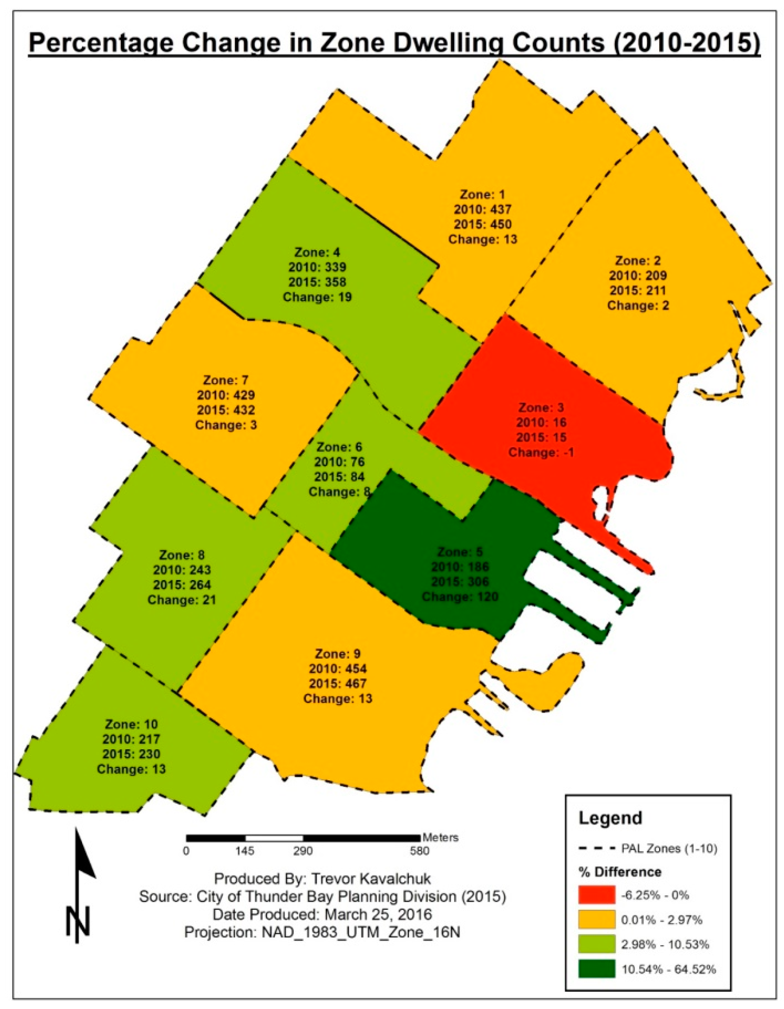
32] (p. 2) with the hope it would have a positive economic impact on the immediately-adjacent downtown. The above-mentioned metrics speak very directly to the measurement of economic impacts (with a focus on urban sustainability), such as business composition (or diversity) present in the core and business stability. Moreover, the residential capacity metric has captured both an increase in residential occupancy directly as part of the waterfront project (i.e., 2 condominium buildings added in PAL zone 5,
Figure 3) as well as other increases in residential occupancy across the downtown core. Various intensification strategies such as loft conversions of aged buildings, construction of small apartments and other multi-unit residential buildings, as well as the conversion of a notable number of single family dwellings to apartment duplex dwellings, were noted in this study (
Table 3;
Figure 4). Facilitating the addition of more multi-unit residential buildings were the 2010 changes to the City’s zoning with the re-introduction of mixed-use zones (MU1 and MU2; [
34]), which have been assigned to areas surrounding the downtown core and elsewhere across the City previously zoned as exclusively single family detached (R1) or mixed housing detached and semi-detached (R2) housing. These intensification projects, some directly the result of the PAL waterfront project (i.e., condo buildings) and others in response from private investors and a change in city permissions (i.e., zoning) have led to a notable increase in gross residential density in the North Core from 12.7 du/ha (in 2010) to 13.7 du/ha (in 2015). Having an increased number of residents living downtown provides direct benefits to downtown businesses and is clearly in alignment with city goals of creating vibrant and diverse mixed-use communities [
33], and has allowed the City to realize measurable action towards intensification and a better mixing of mixed primary land uses as articulated in the Provincial Policy Statement [
42].
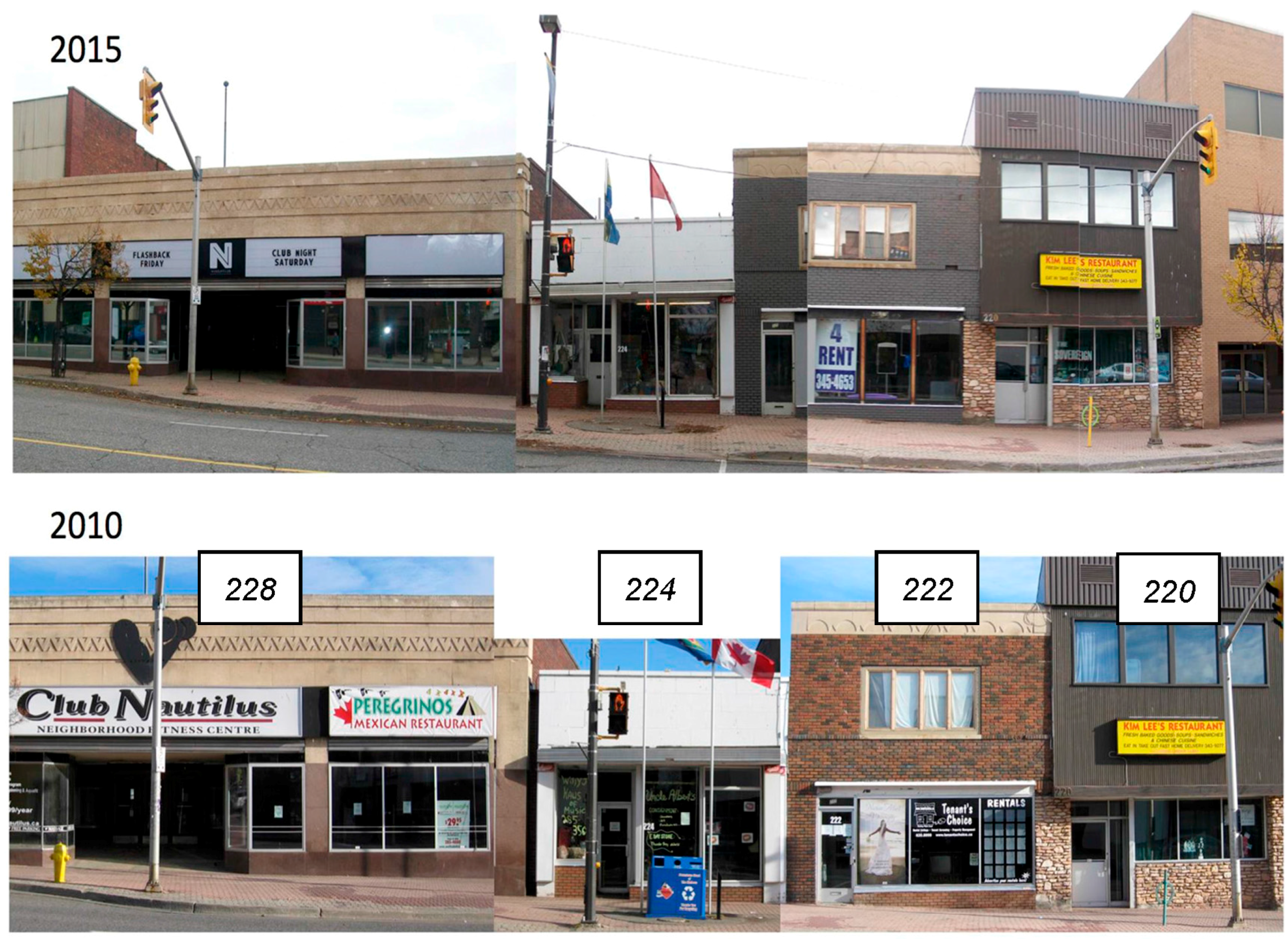
While the residential capacity metric has shown a positive trend from 2010 to 2015, the same cannot be said for the other two business-themed sustainability metrics. The overall trend in business composition over the five year period shows an increase in building vacancy and no new commercial buildings built during the period. Most business sectors have seen small changes during the period and the overall rate vacancy rate is 13.2% as of 2015 (58 of 441 storefronts vacant;
Table 5), an increase from 10.6% in 2010. The food retail and restaurant business sector is the only one seeing a modest increase during the period and reflective of a growing recognition of a downtown bar and restaurant scene as part of the North Core’s branding as the City’s ‘Entertainment District’. However, the loss of traditional downtown functions such as clothing retailers, financial services (such as banks), insurance companies and other professional services has continued, which are relocating to the City’s Intercity area and more suburban locales. This loss of business diversity in the downtown North Core—a move away from the traditional downtown functions—is interpreted as a negative trend with respect to urban sustainability and has a net negative effect on the vibrancy of the downtown core.
Despite the current state of the commercial sector in Thunder Bay, the longer-term prospects in the North Core are encouraging with the City’s continued focus on strengthening and revitalizing its two downtown cores. Important in such revitalizations efforts is the differentiation of the North and South cores, as the ‘Entertainment District’ and ‘Business District’ respectively, so that they can both flourish in the current economic reality in which they are situated. The metrics developed in this initial five year period following the initiation of the waterfront renewal project at Prince Arthur’s Landing will be part of a long-term assessment of this and other efforts by the City over the coming years. These metrics capture data not typically well-documented in downtown cores, yet are accessible and easy-to-understand metrics by which the community can track progress on its goals towards economic well-being and other sustainability goals liked mixed-used, pedestrian-oriented and socially-vibrant districts with sufficient density to support local amenities such as schools and public transit. This study has presented a novel dataset and conceptualized three metrics, which together represents a new approach to assessment of urban sustainability in a downtown core. The approach presented here could be adopted by any jurisdiction interested in tracking changes in residential capacity and/or commercial activities in response to revitalization strategies they may be undertaking. The frequency of database sampling (five years in this study) would need to be shortened in places experiencing a greater rapidity of urban growth than has been observed in the current study.


