Remote Sensing of Hydrological Changes in Tian-e-Zhou Oxbow Lake, an Ungauged Area of the Yangtze River Basin

Abstract
:1. Introduction
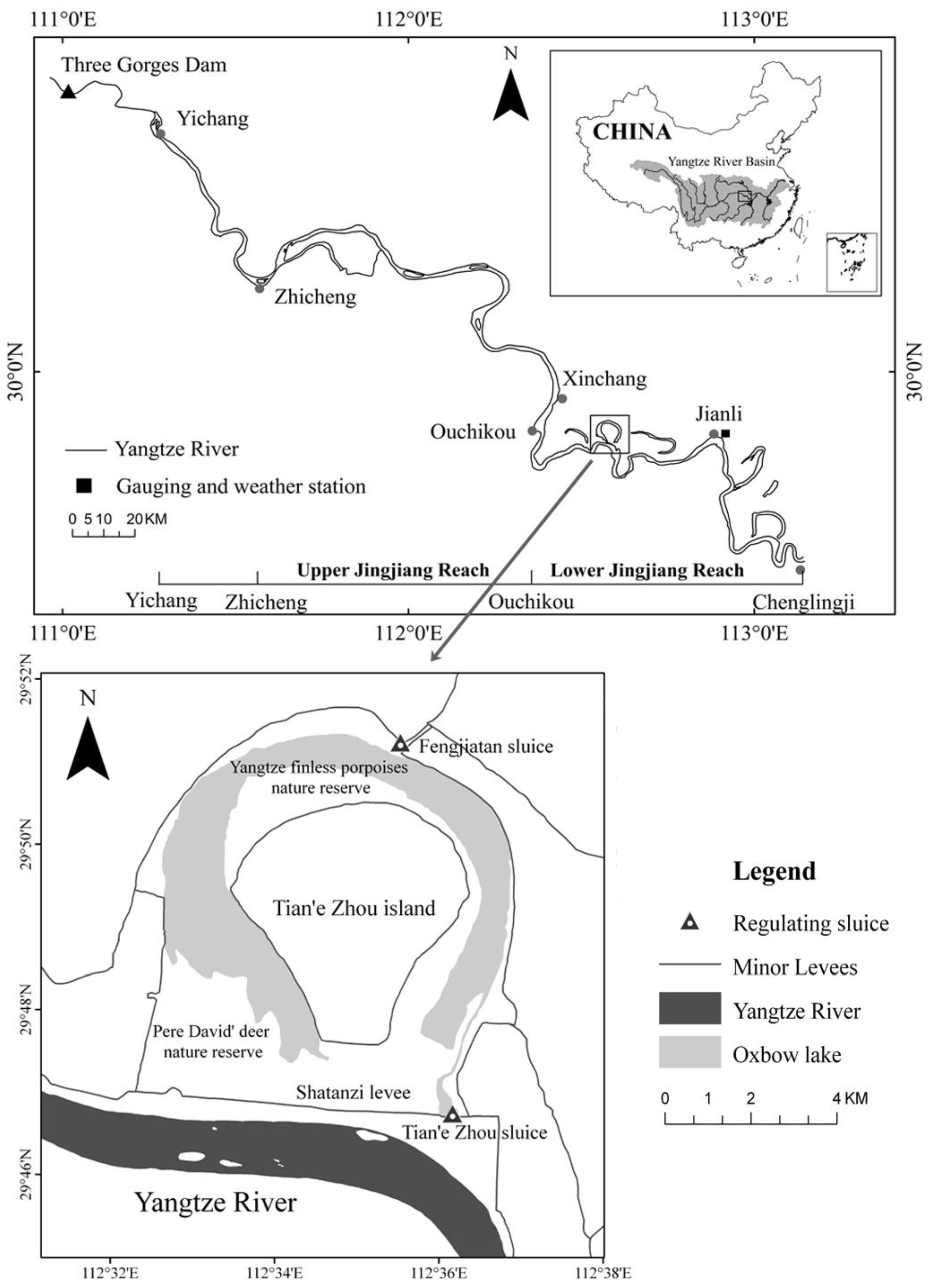
2. Study Area
3. Data and Methods
3.1. Data Collection and Processing
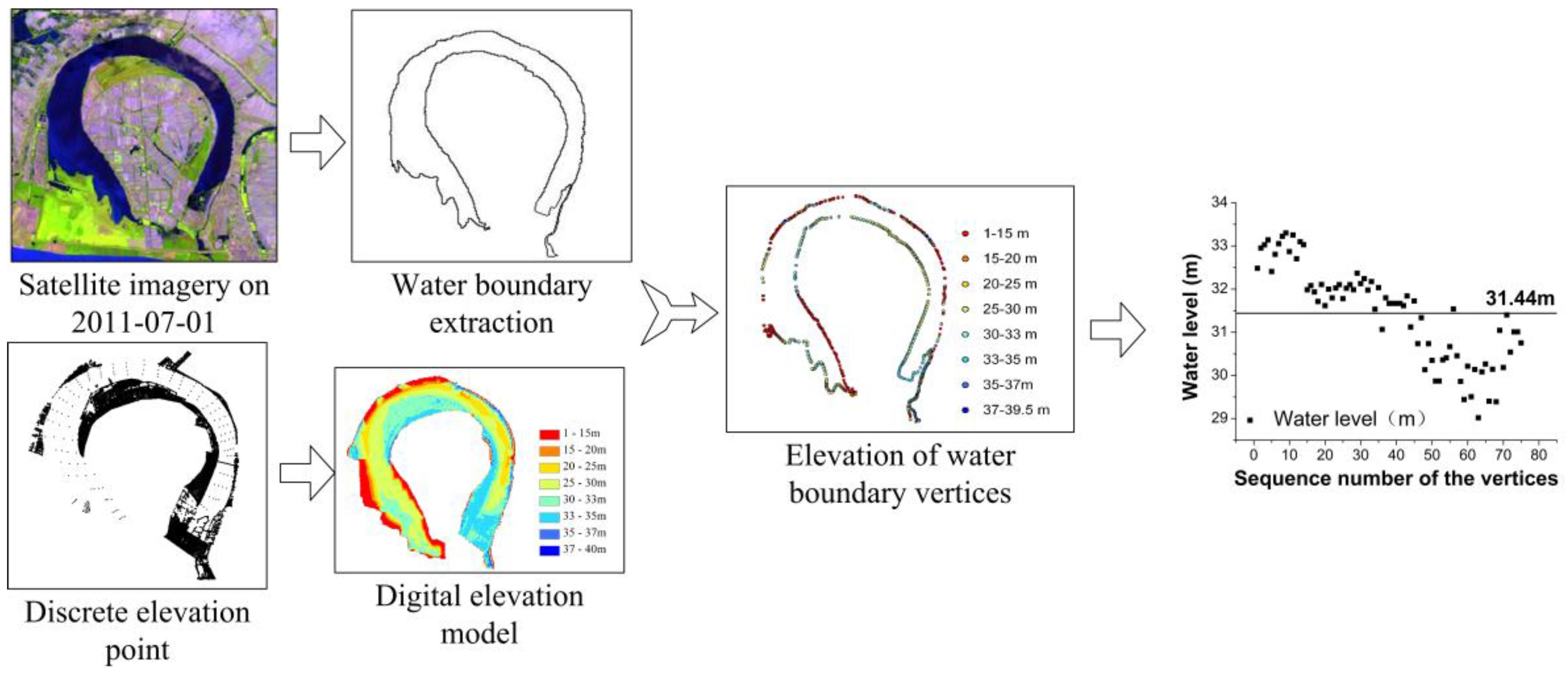
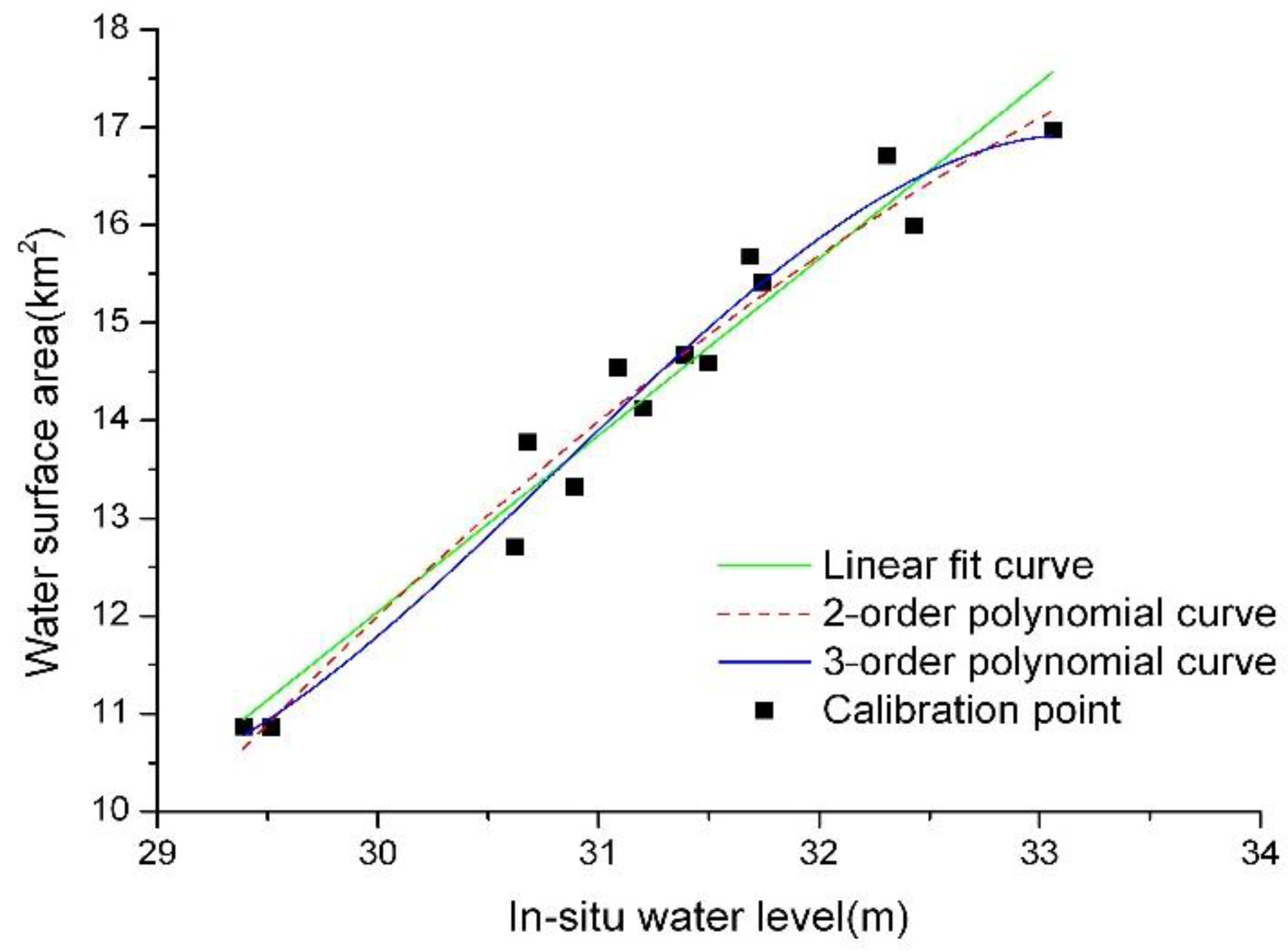
3.2. Water Level Data Extraction and Results Validation
4. Results
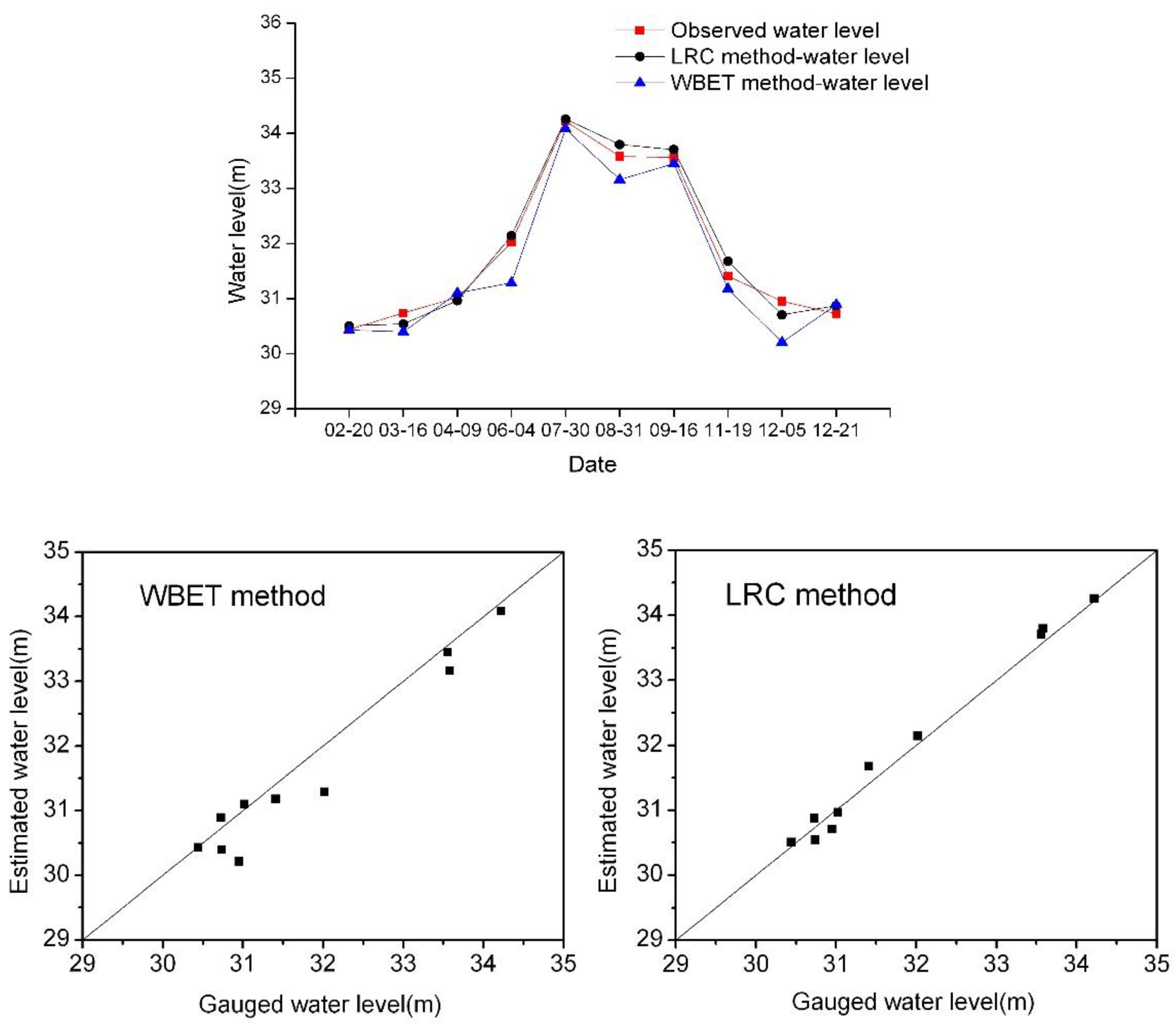
4.1. Water Level Data Extracted from the Two Methods and Their Comparison
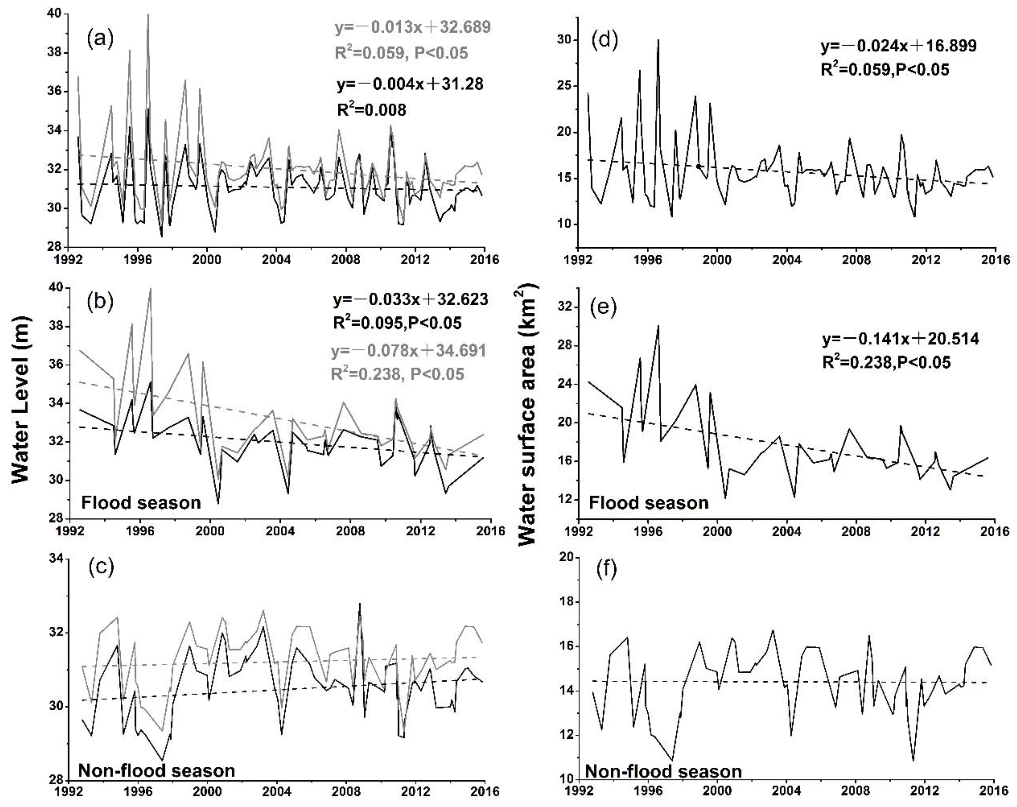
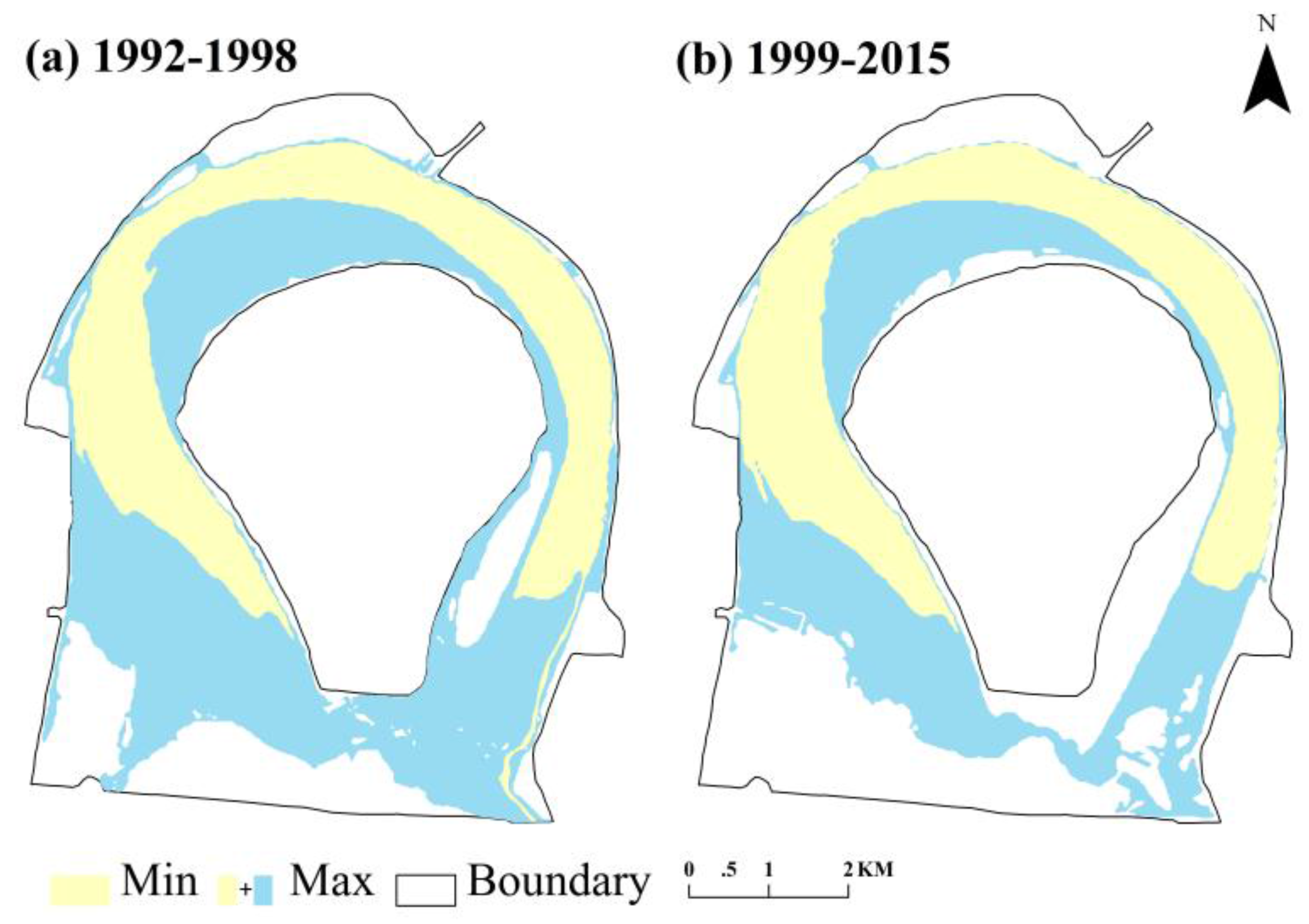
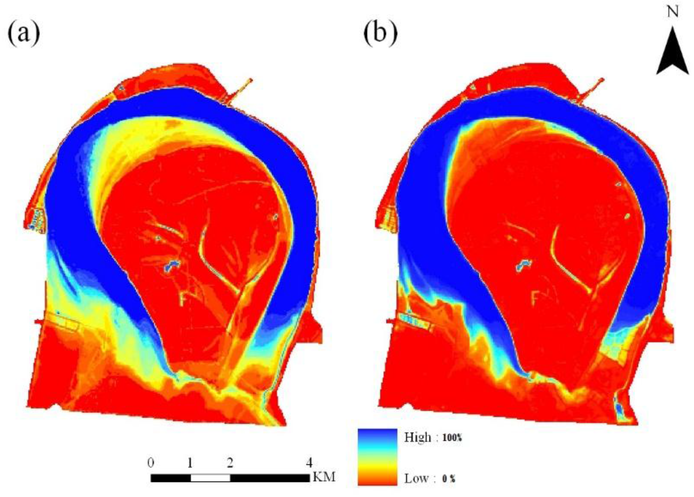
4.2. Hydrologic Pattern Changes in the Oxbow Lake
5. Discussion
5.1. Uncertainty Analysis of the Water Level Estimation
5.2. Reason and Influence Analysis of Hydrologic Pattern Changes
6. Conclusions
Acknowledgments
Author Contributions
Conflicts of Interest
References
- Wang, S.; Chen, Z.; Smith, D.G. Anastomosing river system along the subsiding middle Yangtze River Basin, southern China. Catena 2005, 60, 147–163. [Google Scholar] [CrossRef]
- Shao, X.; Wang, H.; Wang, Z. Fluvial processes in the Lower Jingjiang River: Impact of the Three Gorges Reservoir impoundment. Int. J. Sediment Res. 2005, 20, 102. [Google Scholar]
- Wang, Z.; Chen, Z.; Li, M.; Chen, J.; Zhao, Y. Variations in downstream grain-sizes to interpret sediment transport in the middle-lower Yangtze River, China: A pre-study of Three-Gorges Dam. Geomorphology 2009, 113, 217–229. [Google Scholar] [CrossRef]
- Yang, C.; Cai, X.; Wang, X.; Yan, R.; Zhang, T.; Zhang, Q.; Lu, X. Remotely sensed trajectory analysis of channel migration in lower Jingjiang reach during the period of 1983–2013. Remote Sens. 2015, 7, 16241–16256. [Google Scholar] [CrossRef]
- Jiang, L.; Ban, X.; Wang, X.; Cai, X. Assessment of hydrologic alterations caused by the Three Gorges Dam in the middle and lower reaches of Yangtze River, China. Water 2014, 6, 1419–1434. [Google Scholar] [CrossRef]
- Li, Q.; Yu, M.; Lu, G.; Cai, T.; Bai, X.; Xia, Z. Impacts of the Gezhouba and Three gorges Reservoirs on the sediment regime in the Yangtze River, China. J. Hydrol. 2011, 403, 224–233. [Google Scholar] [CrossRef]
- Yin, H.; Liu, G.; Pi, J.; Chen, G.; Li, C. On the river–lake relationship of the middle Yangtze Reaches. Geomorphology 2007, 85, 197–207. [Google Scholar] [CrossRef]
- Chuntian, C. Fuzzy optimal model for the flood control system of the upper and middle reaches of the Yangtze River. Hydrol. Sci. J. 1999, 44, 573–582. [Google Scholar] [CrossRef]
- Ibrahim, B.; Wisser, D.; Barry, B.; Fowe, T.; Aduna, A. Hydrological predictions for small ungauged watersheds in the Sudanian zone of the Volta Basin in west Africa. J. Hydrol. Reg. Stud. 2015, 4 Pt B, 386–397. [Google Scholar] [CrossRef]
- Dai, S.B.; Lu, X.X. Sediment deposition and erosion during the extreme flood events in the middle and lower reaches of the Yangtze River. Quat. Int. 2010, 226, 4–11. [Google Scholar] [CrossRef]
- Zhou, Y.; Jeppesen, E.; Li, J.; Zhang, Y.; Zhang, X.; Li, X. Impacts of Three Gorges Reservoir on the sedimentation regimes in the downstream-linked two largest Chinese freshwater lakes. Sci. Rep. 2016, 6, 35396. [Google Scholar] [CrossRef] [PubMed]
- Lakshmi, V. The role of satellite remote sensing in the prediction of ungauged basins. Hydrol. Process. 2004, 18, 1029–1034. [Google Scholar] [CrossRef]
- Smith, L.C. Satellite remote sensing of river inundation area, stage, and discharge: A review. Hydrol. Process. 1997, 11, 1427–1439. [Google Scholar] [CrossRef]
- Alsdorf, D.E.; Rodríguez, E.; Lettenmaier, D.P. Measuring surface water from space. Rev. Geophys. 2007, 45, 2637–2655. [Google Scholar] [CrossRef]
- Chu, Y.; Li, J.; Jiang, W.; Zou, X.; Fan, C.; Xu, X.; Dadzie, I. Monitoring level fluctuations of the lakes in the Yangtze River Basin from radar altimetry. Terr. Atmos. Ocean. Sci. 2008, 19, 63–70. [Google Scholar] [CrossRef]
- Schumann, G.; Bates, P.D.; Horritt, M.S.; Matgen, P.; Pappenberger, F. Progress in integration of remote sensing-derived flood extent and stage data and hydraulic models. Rev. Geophys. 2009, 47, RG4001. [Google Scholar] [CrossRef]
- Tseng, K.H.; Shum, C.K.; Kim, J.W.; Wang, X. Integrating landsat imageries and digital elevation models to infer water level change in Hoover Dam. IEEE J. Sel. Top. Appl. Earth Obs. Remote Sens. 2016, 9, 1696–1709. [Google Scholar] [CrossRef]
- Brakenridge, G.R.; Knox, J.C.; Paylor, E.D., II; Magilligan, F.J. Radar remote sensing aids study of the great flood of 1993. Earth Space Sci. News 1994, 75, 521–527. [Google Scholar] [CrossRef]
- Cai, X.; Gan, W.; Ji, W.; Zhao, X. Optimizing remote sensing-based level—Area modeling of large lake wetlands: Case study of Poyang Lake. IEEE J. Sel. Top. Appl. Earth Obs. Remote Sens. 2015, 8, 471–479. [Google Scholar] [CrossRef]
- Pan, F.; Liao, J.; Li, X.; Guo, H. Application of the inundation area—Lake level rating curves constructed from the SRTM DEM to retrieving lake levels from satellite measured inundation areas. Comput. Geosci. 2013, 52, 168–176. [Google Scholar] [CrossRef]
- Wang, T.; Wang, H.S.; Sun, G.W.; Huang, D.; Shen, J.H. Length-weight and length-length relationships for some Yangtze river fishes in Tian-e-zhou oxbow, China. J. Appl. Ichthyol. 2012, 28, 660–662. [Google Scholar] [CrossRef]
- Jiang, Z.; Yu, C.; Feng, Z.; Zhang, L.; Xia, J.; Ding, Y.; Lindsay, N. Reintroduction and recovery of Père David’s deer in China. Wildl. Soc. Bull. 2000, 28, 681–687. [Google Scholar]
- Wang, D. Population status, threats and conservation of the Yangtze finless porpoise. Chin. Sci. Bull. 2009, 54, 3473–3484. [Google Scholar] [CrossRef]
- Mei, Z.; Zhang, X.; Huang, S.L.; Zhao, X.; Hao, Y.; Zhang, L.; Qian, Z.; Zheng, J.; Wang, K.; Wang, D. The Yangtze finless porpoise: On an accelerating path to extinction? Biol. Conserv. 2014, 172, 117–123. [Google Scholar] [CrossRef]
- Jiang, Z.; Li, C.W.; Yang, D.D.; Zeng, Y.; Fang, H.X. Père david deer in China: Current status and conservation strategies. In Proceedings of the 20th Annuversary of Milu Returning Dafeng; Nanjing Normal University Press: Nanjing, China, 2008; pp. 1–14. [Google Scholar]
- Chen, J.; Zhu, X.; Vogelmann, J.E.; Gao, F.; Jin, S. A simple and effective method for filling gaps in Landsat ETM+ SLC-off images. Remote Sens. Environ. 2011, 115, 1053–1064. [Google Scholar] [CrossRef]
- Scaramuzza, P.; Micijevic, E.; Chander, G. Slc Gap-Filled Products Phase One Methodology. Available online: http://landsat.usgs.gov/documents/L7SLCGapFilledMethod.pdf (accessed on 12 January 2017).
- Hui, F.; Xu, B.; Huang, H.; Yu, Q.; Gong, P. Modelling spatial-temporal change of Poyang lake using multitemporal Landsat imagery. Int. J. Remote Sens. 2008, 29, 5767–5784. [Google Scholar] [CrossRef]
- Jain, S.K.; Singh, R.; Jain, M.; Lohani, A. Delineation of flood-prone areas using remote sensing techniques. Water Resour. Manag. 2005, 19, 333–347. [Google Scholar] [CrossRef]
- McFeeters, S. The use of the normalized difference water index (NDWI) in the delineation of open water features. Int. J. Remote Sens. 1996, 17, 1425–1432. [Google Scholar] [CrossRef]
- Guo, B.M.; Wang, T.; Zhao, R. Research on extracting skeleton line of polygon. In Proceedings of the 2nd IEEE International Conference on Information Management and Engineering (ICIME), Chengdu, China, 16–18 April 2010; pp. 514–517. [Google Scholar]
- Shen, B.; Zhang, S.; Yang, H.; Wang, K.; Feng, G. Analysis of characteristics of a sharp turn from drought to flood in the middle and lower reaches of the Yangtze River in spring and summer in 2011. Acta Phys. Sin. 2012, 61, 109202. [Google Scholar]
- Ling, F.; Cai, X.; Li, W.; Xiao, F.; Li, X.; Du, Y. Monitoring river discharge with remotely sensed imagery using river island area as an indicator. J. Appl. Remote Sens. 2012, 6, 063564. [Google Scholar] [CrossRef]
- Wise, S.M. The effect of GIS interpolation errors on the use of digital elevation models in geomorphology. Landf. Monit. Model. Anal. 1998, 99, 139–164. [Google Scholar]
- Sakamoto, T.; Van Nguyen, N.; Kotera, A.; Ohno, H.; Ishitsuka, N.; Yokozawa, M. Detecting temporal changes in the extent of annual flooding within the Cambodia and the Vietnamese Mekong delta from modis time-series imagery. Remote Sens. Environ. 2007, 109, 295–313. [Google Scholar] [CrossRef]
- Brivio, P.; Colombo, R.; Maggi, M.; Tomasoni, R. Integration of remote sensing data and GIS for accurate mapping of flooded areas. Int. J. Remote Sens. 2002, 23, 429–441. [Google Scholar] [CrossRef]
- Han, J.; Sun, Z.; Huang, Y.; Li, Y. Features and causes of sediment deposition and erosion in Jingjiang reach after impoundment of the Three Gorges Project. J. Hydraul. Eng. 2014, 45, 277–295. [Google Scholar]
- Yin, H.; Li, C. Human impact on floods and flood disasters on the Yangtze River. Geomorphology 2001, 41, 105–109. [Google Scholar] [CrossRef]
- Yin, R.L. Effect of lower-Jingjiang river evolution on Tianezhou natural protect area and countermeasures. J. Yangtze River Sci. Res. Inst. 2006, 23, 1–4. [Google Scholar]
- Zhu, Y.; Liao, W.; Feng, S. Study on the physical habitat characteristics of Yangtze finless porpoise in Tian-e-zhou oxbow of Yangtze river. J. China Inst. Water Resour. Hydropower Res. 2012, 10, 158–191. [Google Scholar]
- Zhang, Y.; Wang, M.; Xiao, Z.; Tang, Y.; Fang, F.; Li, P.; Liu, S. Land use dynamic change analysis based on “3s” technology in Shishou David’s deer national nature reserve. For. Inventory Plan. 2013, 38, 16–20. [Google Scholar]
- Yang, D.; Li, M.; Cheng, Y.; Wen, H.; Li, P.; Xu, F.; Li, W. Quantitative classification and ordination of wetland vegetations in oxbows, Yangtze River. Plant Sci. J. 2011, 29, 467–473. [Google Scholar]
- Li, P.; Yang, T.; Zhang, Y.; Cai, J.; Sha, P.; Wang, J. Habitats of edible plants for wild Milu population in Shishou and its restoration approach. J. Yangtze Univ. 2015, 12, 48–50. [Google Scholar]
- Ni, Z. Environmental and Ecological Impact Assessment of Rivers and Lakes Connection; Yangtze River Fisheries Research Institute, Chinese Academy Of Fishery Sciences: Wuhan, China, 2006. [Google Scholar]


| Fitting Equations | R-Squared | RMSE (m) |
|---|---|---|
| y = 1.80538x − 42.1172 | 0.949 | 0.219 |
| y = −0.14654x2 + 10.9308x − 184.035 | 0.956 | 0.209 |
| y = −0.12991x3 + 12.00946x2 − 367.90225x + 3747.8398 | 0.959 | 0.215 |
| Methods | RMSE (m) | MRE | R |
|---|---|---|---|
| WBET method | 0.386 | 0.9% | 0.975 |
| LRC method | 0.168 | 0.4% | 0.994 |
| Flood Season (June–September) | Non-Flood Season (October–May) | ||||||||
|---|---|---|---|---|---|---|---|---|---|
| 1992–1998 | 1999–2015 | 1992–1998 | 1999–2015 | ||||||
| WBET | LRC | WBET | LRC | WBET | LRC | WBET | LRC | ||
| Mean annual water level (m) | 33.06 | 35.51 | 31.59 | 32.3 | 29.65 | 30.72 | 30.77 | 31.47 | |
| Mean annual water surface area (km2) | 21.99 | 16.19 | 13.35 | 14.70 | |||||
© 2017 by the authors. Licensee MDPI, Basel, Switzerland. This article is an open access article distributed under the terms and conditions of the Creative Commons Attribution (CC BY) license (http://creativecommons.org/licenses/by/4.0/).
Share and Cite
Yang, C.; Cai, X.; Wang, X. Remote Sensing of Hydrological Changes in Tian-e-Zhou Oxbow Lake, an Ungauged Area of the Yangtze River Basin. Remote Sens. 2018, 10, 27. https://doi.org/10.3390/rs10010027
Yang C, Cai X, Wang X. Remote Sensing of Hydrological Changes in Tian-e-Zhou Oxbow Lake, an Ungauged Area of the Yangtze River Basin. Remote Sensing. 2018; 10(1):27. https://doi.org/10.3390/rs10010027
Chicago/Turabian StyleYang, Chao, Xiaobin Cai, and Xuelei Wang. 2018. "Remote Sensing of Hydrological Changes in Tian-e-Zhou Oxbow Lake, an Ungauged Area of the Yangtze River Basin" Remote Sensing 10, no. 1: 27. https://doi.org/10.3390/rs10010027
APA StyleYang, C., Cai, X., & Wang, X. (2018). Remote Sensing of Hydrological Changes in Tian-e-Zhou Oxbow Lake, an Ungauged Area of the Yangtze River Basin. Remote Sensing, 10(1), 27. https://doi.org/10.3390/rs10010027