1. Introduction
Land cover change is one of the most important factors profoundly affecting the earth’s ecological systems [
1,
2]. Land cover changes can be related to natural processes (e.g., flooding, wildfire) and anthropogenic activities (e.g., urbanization, agriculture). The rate of change and the nature of land cover changes can also differ in time and space [
3]. Some regions are relatively stable (e.g., permanent forest), whereas other areas are subject to rapid and persistent transformation (e.g., urban expansion of previously vegetated areas). Previous studies showed that land cover change can lead to either increases or decreases in vegetation greenness [
4,
5,
6]. For example, the changes from agricultural land or forests to developed land usually result in a decrease in vegetation greenness [
4]. Conversely, returning agricultural land to forest and grassland, reforestation, and afforestation can lead to increases in greenness [
5]. As a key component of terrestrial ecosystems, vegetation has an irreplaceable role in regulating material and energy cycles [
7,
8]. The associations between vegetation dynamics and land cover change have attracted great attention in recent decades [
5,
6,
8,
9,
10,
11]. However, most research was conducted at coarse spatial resolution by analyzing time series of satellite data (such as Advanced Very High Resolution Radiometer (AVHRR) and Moderate Resolution Imaging Spectroradiometer (MODIS)) at global and national levels [
6,
12,
13]. It is hard to accurately detect land cover changes occurring at finer spatial scales, and difficult to provide specific guidance for local land management. Additionally, much of the research used limited land cover data in specific years to analyze the impact of land cover change on long-time vegetation dynamics [
4,
5,
6,
12]. This may not introduce large errors in more stable areas, but could be problematic for places that exhibit high rates of land cover change. Thus it is necessary to produce more dense land cover maps to minimize potential omission errors from bi-temporal data [
3,
4].
Coastal land cover across the globe has experienced remarkable change in recent decades due to extraordinary anthropogenic pressure, technological development, and climate change [
14,
15]. Coastal reclamation is capable of creating abundant land to alleviate the pressure from land shortages. However, it significantly changes the land cover pattern with landscape fragmentation and modification to vegetation distribution and type [
16,
17,
18]. Compared to climatic factors, human activity-dominant reclamations affect vegetation growth more directly and efficiently [
5]. Positive human activities, such as establishment of wetland parks, can promote local vegetation restoration. Negative human activities, such as urban expansion, may exert pressure on the natural environment and contribute significantly to vegetative degradation [
6,
19]. Assessing the location, extent, type, and frequency of land cover changes at finer spatial scale is critical for thoroughly understanding the consequences of reclamations.
Reclamation projects such as industrial and agricultural construction, aquaculture, maritime transport, and energy exploitation in the coastal zones have resulted in a sharp increase in the human demand for marine and coastal resources, and significant reduction of wetland areas. Reclamation activities provide large socioeconomic benefits and construction lands but jeopardize the coastal wetland ecosystems and services [
16,
20]. Vegetation is one of the most important indicators of wetland ecosystem services, as it provides habitat, food, carbon storage, coastal erosion prevention, etc. [
16,
18,
21], and reclamations greatly change the environment of plant growth. The rapid development of large-scale construction lands in coastal areas lead to the disappearance of plants, while barrier, aquaculture, and herbaceous marsh influence vegetation types and their regrowth ability [
21]. Quantifying the land cover changes and their impacts on vegetation growth are critical for evaluation of services and protection of coastal wetland ecosystems [
22].
The coastal wetland is a complex ecosystem composed of water, sand, mud flat, and numerous vegetation species [
23]. Previous studies mostly focused on examining the coastal line or reclaimed area dynamics [
24]. The wetland changes and their impacts on wetland vegetation growth are rarely investigated, making it difficult to conduct a comprehensive assessment of the ecological changes in these strongly disturbed coastal areas. The limited data coverage from traditional field surveys makes it a challenge to monitor large-scale changes and their responses to these intense reclamation activities. Time-series satellite data provide the opportunity to analyze land cover change and vegetation greenness trends over large areas [
25]. Currently, analysis of trends in vegetation greenness is generally focused on very large areas [
13], or at local and regional scales in forest [
26], drylands [
27], urban [
4], and tundra areas [
28], but the coastal reclaimed areas have not received much attention.
Remote sensing is one of the most important ways to monitor wetland dynamics [
24], and many change detection techniques such as principal component analysis, image differencing, and post-classification comparison can be used [
29,
30,
31]. However, the wetland hydroperiod, the tidal level, and the acquisition time of remote sensing data may considerably affect wetland monitoring results. It is not easy to determine the optimal time to detect wetland change, especially for those areas influenced strongly by precipitation and tidal level [
32], resulting in substantial uncertainty of wetland monitoring results and inconsistency among different studies. The dense Landsat time-series data can provide more characteristics of land cover [
25], and will be helpful for wetland changes monitoring. By using all available observations and considering each pixel separately, the limitations like the failure of the Scan Line Corrector (SLC) in Landsat 7, clouds and shadows, and snow can be overcome. Another advantage is that relative normalization for each image is not needed because the time-series model already takes into account the effects of phenology and sun angle differences [
25,
33,
34]. However, most previous studies using dense Landsat data focused on detection of forest cover change (e.g., disturbance/regrowth) [
33,
34,
35]; rarely has that type of research been used to investigate coastal areas exhibiting intense land cover change [
24].
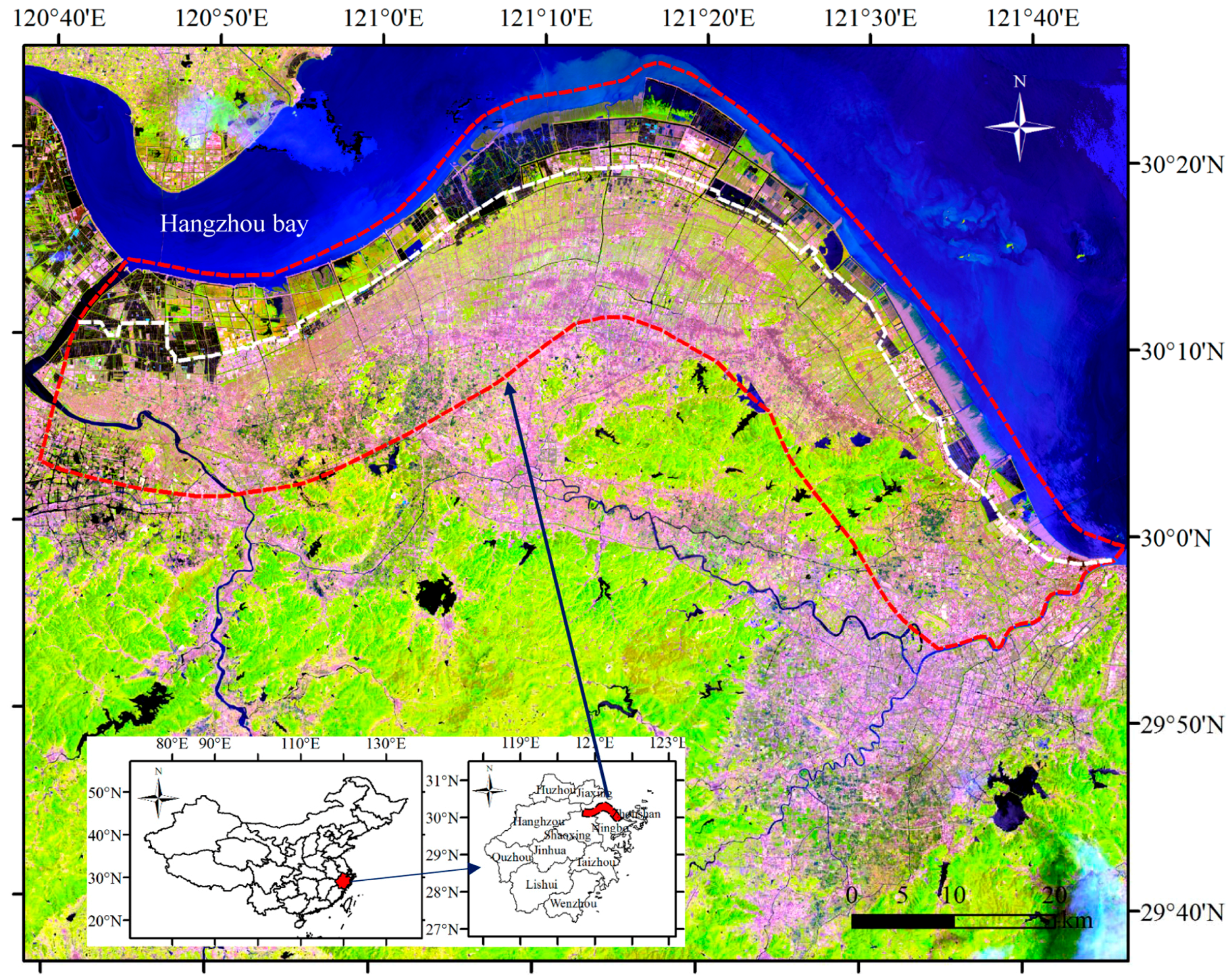
To meet the increasing demand of new lands for city expansion, agricultural purposes, industrial use, or port expansions, large areas of coastal zones in China have been reclaimed since the 1980s [
36]. For example, during the past 30 years, more than 400,000 ha of tidelands have been reclaimed in Zhejiang Province. It is equivalent to 4.1% of the total area of Zhejiang Province. Hangzhou Bay in Zhejiang Province is one of the coastal reclamation hotspots in China [
37]. Large-area reclamation promoted the local marine economy and guaranteed the construction land demand but caused a series of resource and ecological problems due to partial and complete land cover changes [
37]. How did these reclamations and land cover changes influence the vegetation growth? Did the changing trend of vegetation growth significantly differ from the non-reclamation area? Clarifying these questions is fundamental for government and managers to establish scientific and sustainable policies for coastal reclamation and wetland utilization.
This research attempts to answer the following questions: (1) Do the dense Landsat time-series data perform well for land cover change detection in coastal areas? (2) What major land cover changes occurred in Hangzhou Bay in the past three decades? (3) Do the coastal wetland reclamations provide sufficient areas for construction lands and alleviate the local cropland occupation? (4) How do the land cover changes influence the vegetation greenness trends in newly reclaimed area and what are the differences with the inland region? To answer these questions, dense Landsat time-series data from 1984 to 2016 were used to detect the land cover change and assess its influence on vegetation greenness in Hangzhou Bay, Zhejiang Province.
5. Conclusions
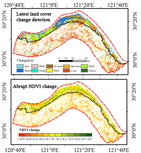
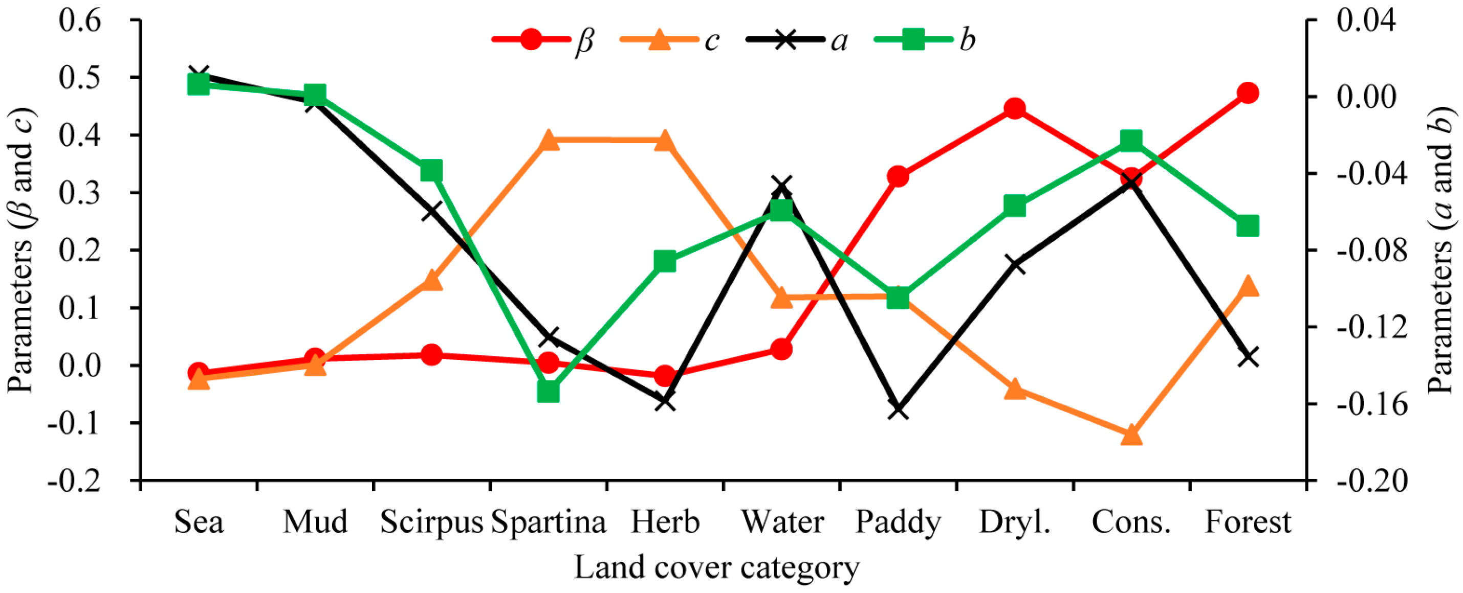
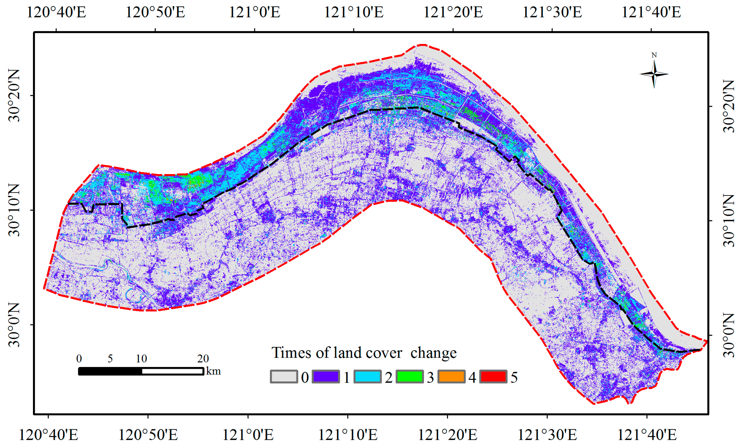
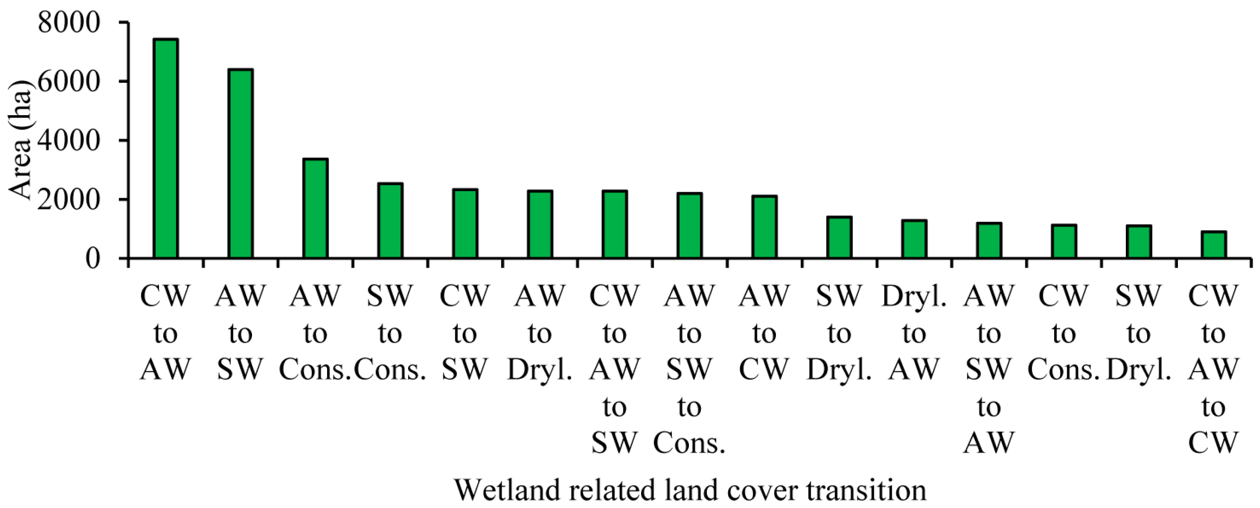
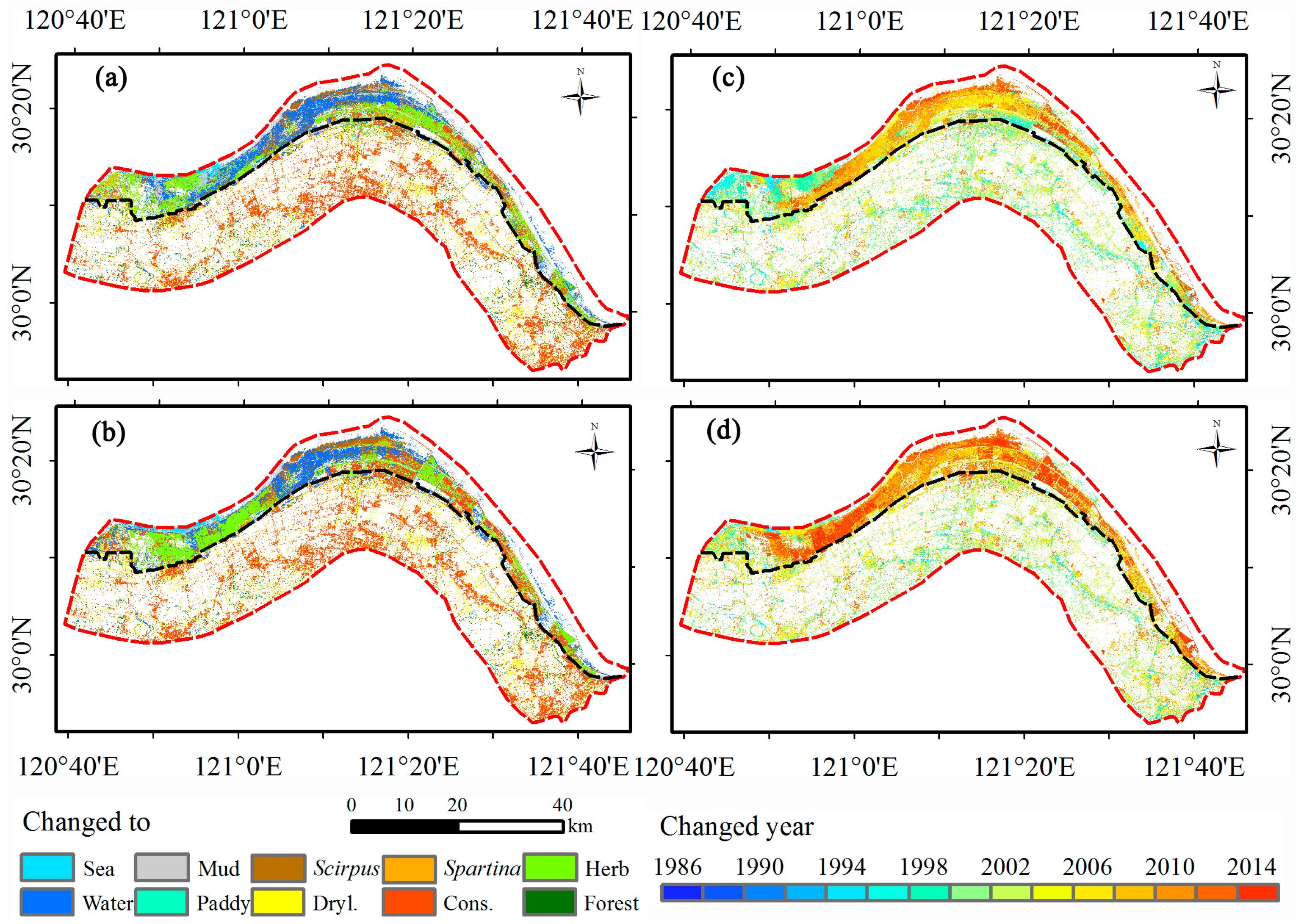
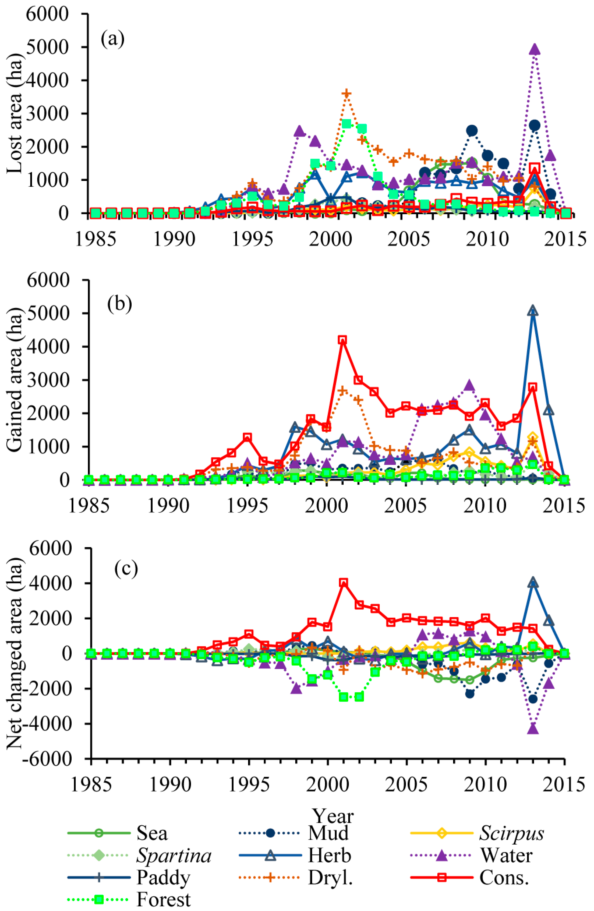
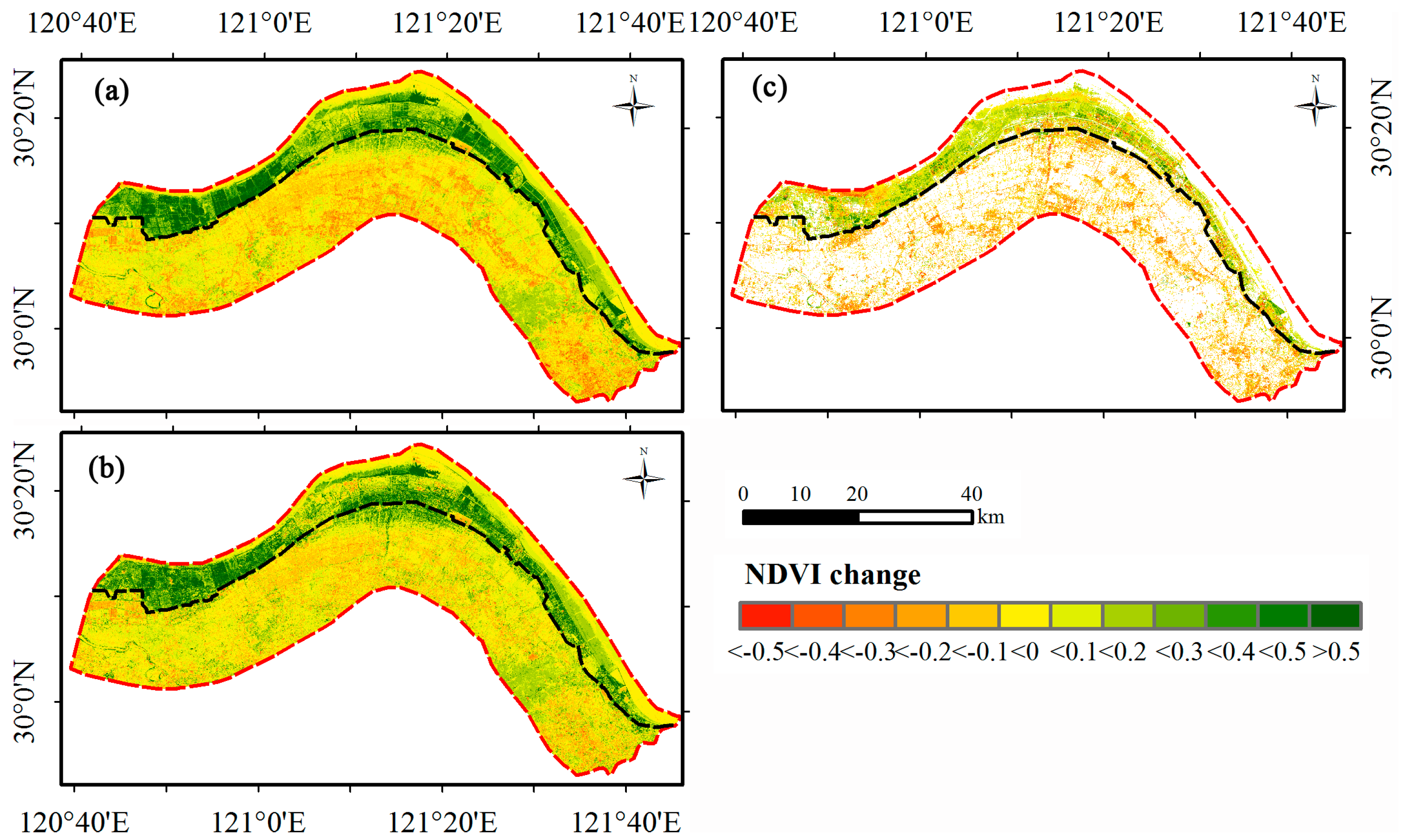
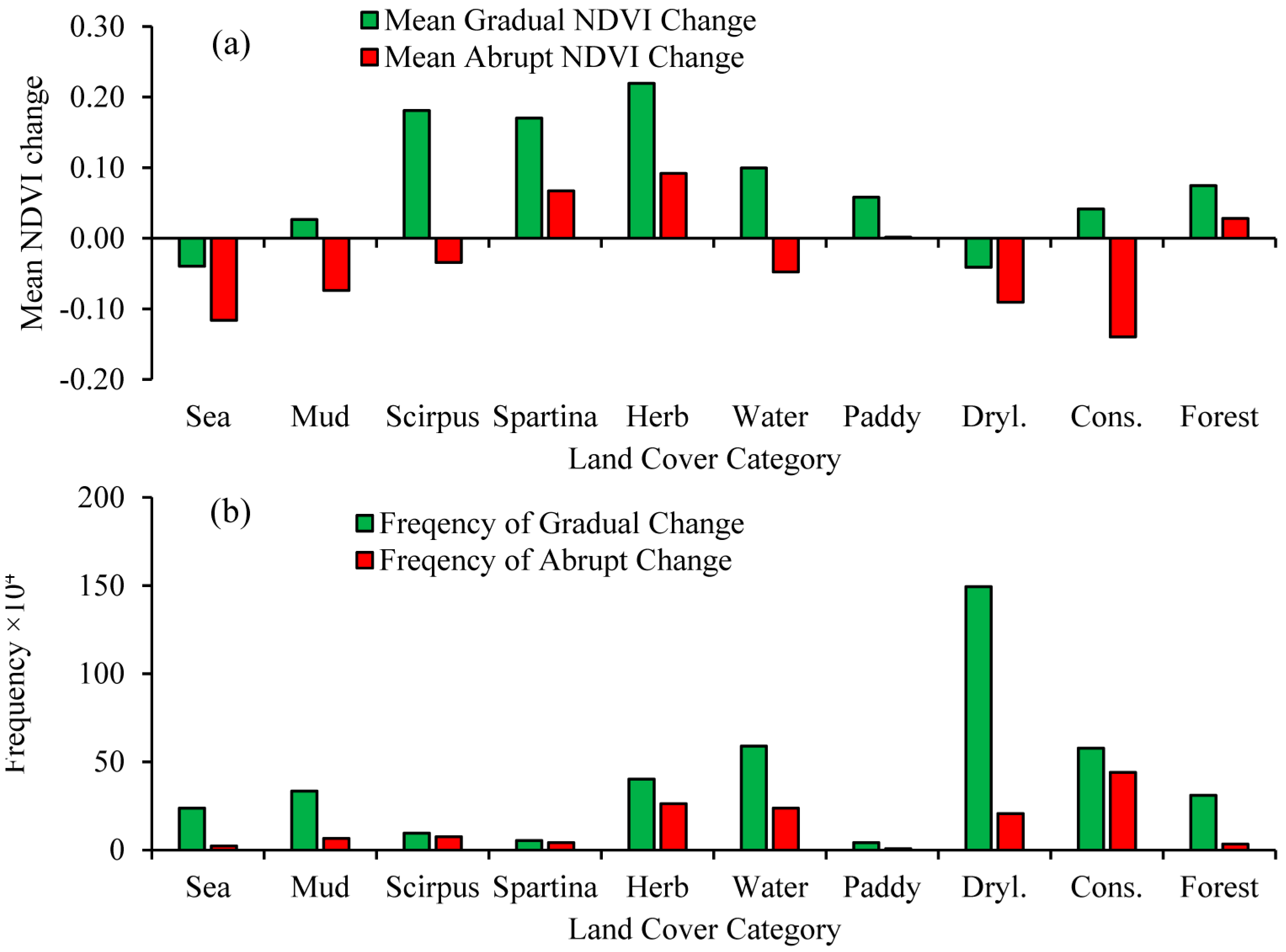
This study integrated dense Landsat time-series data, BFAST algorithm, and the Random Forest classification method to study the land cover change and vegetation greenness variations of Hangzhou Bay during 1987–2015. The overall accuracies of 88.7% for land cover change and 91.0% for ten land cover classifications were obtained. The area experienced land cover change amounts to 39% of the study area, and showed spatial‒temporal dynamics. The intense changes mainly occurred in 1995, 2001, and 2013, coincident with the local policy and the establishment of Hangzhou Bay New Zone and Hangzhou Bay National Wetland Park. For the inland area, urbanization was the main driver of the land cover change and mostly occurred before 2005. The land cover change reduced mean vegetation greenness because the conversions from construction land to dryland and from forest to dryland were the dominant land cover changes. In the reclaimed area, the land cover was mainly changed to herb, water, and construction land. Land cover change has led to the increase of the mean vegetation greenness of the reclaimed area, benefitting from the increased area of herb, water, and Spartina. In summary, construction land and water were the most important contributors to the overall negative abrupt NDVI change trend. Herb and water were the main contributors to the overall increase of NDVI in terms of gradual change.
Using all available Landsat data can provide detailed information about land cover change and vegetation growth in the frequently changed coastal area. This method can take full advantage of vegetation phenology information, avoid the hydroperiod effects, and quantify the abrupt and gradual NDVI changes. Such information of land cover change and impacts on coastal vegetation greenness will help the research and natural resource management communities to generate better understanding of coastal ecosystems and make better management decisions. However, further studies are still ongoing to thoroughly understand the impacts of reclamation and coastal wetland reduction on environmental functions, including biodiversity, rising sea level, and carbon cycle.


