Residuals of Tropospheric Delays from GNSS Data and Ray-Tracing as a Potential Indicator of Rain and Clouds


Abstract
:
1. Introduction
2. Ray-Path Model
3. GNSS Slant Delays Estimation
4. Meteorological Observations
- SYNOP observations,
- radiosonde observations,
- Multisensor Precipitation Estimate (MPE) from European Organisation for the Exploitation of Meteorological Satellites (EUMETSAT),
- Cloud Type (CT) product from Satellite Application Facility on support to Nowcasting (SAFNWC).
5. WRF Model
- Mean Error (ME)—describing the tendency of the model for over (ME ) or underestimation of the given meteorological variable. ME is calculated as a mean difference between the modeled and observed values for all the stations (domain wide statistics). The units are the same as for the analyzed meteorological variable.
- Root Mean Squared Error (RMSE)—calculated as a root of the squared differences between the modeled and observed values for all stations. The units are the same as for the analyzed meteorological variable.
- Pearson correlation coefficient (cor)—takes the values from −1 to +1 and the expected value is 1. Cor is unitless.
- Index of Agreement (IOA; [52]) is a standardized measure of the degree of model prediction error. IOA is unitless, and values vary between 0 and 1 (1 indicates a perfect match).
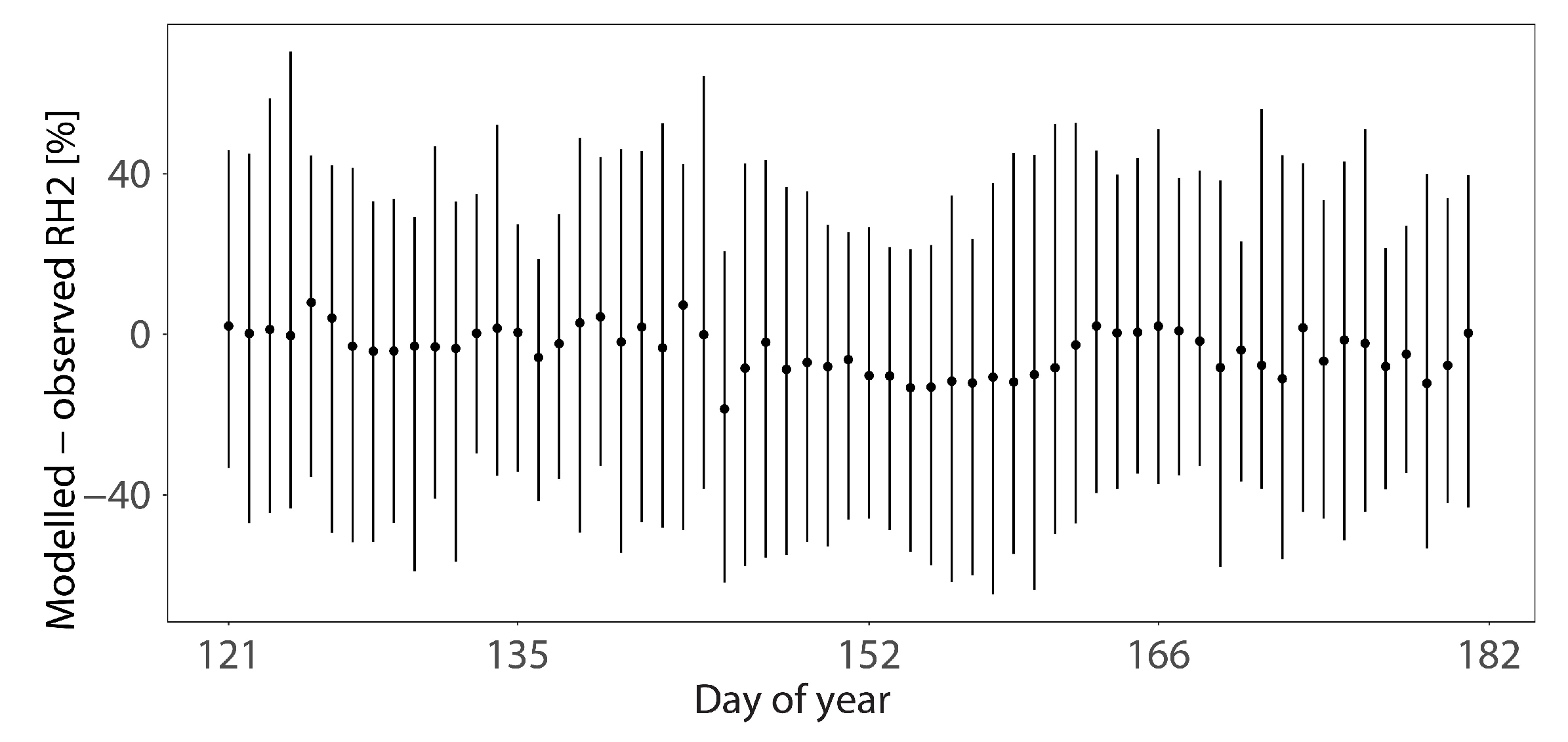
6. WRF Model Evaluation
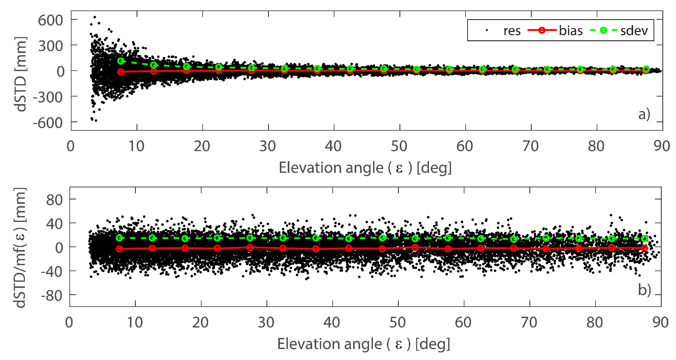
7. Cross-Validation of Ray-Traced and GNSS Slant Delays
8. Uncertainties of Tropospheric Delays
8.1. Uncertainties of Ray-Traced Delays
8.2. GNSS Delays Errors
9. Applications in Weather Monitoring
10. Discussion
11. Conclusions
Author Contributions
Funding
Acknowledgments
Conflicts of Interest
Abbreviations
| CODE | Center for Orbit Determination in Europe |
| COST | European Cooperation in Science and Technology (organization) |
| CT | Cloud Type |
| DCB | Differential Code Biases |
| DOY | Day Of Year |
| GNSS | Global Navigation Satellite System |
| GNSS4SWEC | Advanced Global Navigation Satellite Systems tropospheric products for monitoring severe weather events and climate |
| EGM | Earth Gravitational Model |
| EIG EUMETNET | European Meteorological Services Network |
| ERP | Earth Rotation Parameters |
| EUMETSAT | European Organization for the Exploitation of Meteorological Satellites |
| ESRL | Earth System Research Laboratory |
| E-GVAP | The EUMETNET EIG GNSS Water Vapour Programme |
| ESSEM | Earth System Science and Environmental Management |
| FES | Finite Element Solution |
| HIRLAM | High Resolution Limited Area Model |
| IWV | Integrated Water Vapor |
| MPE | Multisensor Precipitation Estimate |
| NOAA | National Oceanic and Atmospheric Administration |
| NWP | Numerical Weather Prediction |
| PPP | Precise Point Positioning |
| SAFNWC | Satellite Application Facility on Support to Nowcasting |
| STD | Slant Total Delay (of GNSS signal towards satellite, in neutral atmosphere) |
| UTC | Coordinated Universal Time |
| VMF | Vienna Mapping Functions |
| WGS | World Geodetic System |
| WMO | World Meteorologic Organization |
| WRF | Weather Research and Forecasting (model) |
| ZAMG | Zentralanstalt für Meteorologie und Geodynamik |
| ZHD | Zenith Hydrostatic Delay (of GNSS signal in neutral atmosphere) |
| ZTD | Zenith Total Delay (of GNSS signal in neutral atmosphere) |
| ZWD | Zenith Wet Delay (of GNSS signal in neutral atmosphere) |
Appendix A. Computation of Tropospheric Delays from the Ray-Path Model

Appendix B. Modeling of Cloud and Rain Effect on Tropospheric Delays

Appendix C. List of GNSS and Radiosonde Stations

| ID | Latitude [deg] | Longitude [deg] | Altitude [m] | |
|---|---|---|---|---|
| GNSS Stations | ||||
| BOR1 | 52.2769547 | 17.0734520 | 88.855 | |
| GLOG | 51.6652565 | 16.0742817 | 104.529 | |
| GNIE | 52.5329437 | 17.5838547 | 138.839 | |
| JLGR | 50.9194603 | 15.7332487 | 365.712 | |
| KALI | 51.7538757 | 18.0951633 | 111.766 | |
| KLDZ | 50.4355774 | 16.6518860 | 316.457 | |
| LEGN | 51.2000084 | 16.1549683 | 140.163 | |
| LESZ | 51.8403893 | 16.5784855 | 111.106 | |
| OPLE | 50.6676140 | 17.9193401 | 185.575 | |
| WLBR | 50.7679672 | 16.2800694 | 467.014 | |
| WROC | 51.1132584 | 17.0620365 | 140.565 | |
| ZARY | 51.6399193 | 15.1461058 | 163.124 | |
| ZIGR | 51.9403114 | 15.5142927 | 186.068 | |
| Radiosonde Stations | ||||
| 12120 | 54.75 | 17.53 | 6.0 | |
| 12374 | 52.40 | 20.97 | 96.0 | |
| 12425 | 51.13 | 16.98 | 116.0 | |
References
- Brewster, K.; Thomas, K.W.; Gao, J.; Brotzge, J.; Xue, M.; Wang, Y. A nowcasting system using full physics numerical weather prediction initialized with CASA and NEXRAD radar data. In Proceedings of the 25th Conference on Severe Local Storms, Denver, CO, USA, 11–14 October 2010. [Google Scholar]
- Stanešić, A.; Brewster, K.A. Impact of Radar Data Assimilation on the Numerical Simulation of a Severe Storm in Croatia. Meteorol. Z. 2016, 25, 37–53. [Google Scholar] [CrossRef]
- Novak, P. The Czech Hydrometeorological Institute’s severe storm nowcasting system. Atmos. Res. 2007, 83, 450–457. [Google Scholar] [CrossRef]
- Ruzanski, E.; Chandrasekar, V.; Wang, Y. The CASA nowcasting system. J. Atmos. Ocean. Technol. 2011, 28, 640–655. [Google Scholar] [CrossRef]
- Meischner, P. Weather Radar: Principles and Advanced Applications; Springer: Berlin/Heidelberg, Germany, 2005; ISBN 978-3-662-05202-0. [Google Scholar]
- Bevis, M.; Businger, S.; Herring, T.A.; Rocken, C.; Anthes, R.A.; Ware, R.H. GPS meteorology: Remote sensing of atmospheric water vapor using the Global Positioning System. J. Geophys. Res. Atmos. 1992, 97, 15787–15801. [Google Scholar] [CrossRef]
- Davis, J.; Herring, T.; Shapiro, I.; Rogers, A.; Elgered, G. Geodesy by radio interferometry: Effects of atmosphere modeling errors on estimates of baseline lenghts. Radio Sci. 1985, 20, 1593–1607. [Google Scholar] [CrossRef]
- Bennitt, G.V.; Jupp, A. Operational assimilation of GPS zenith total delay observations into the Met Office numerical weather prediction models. Mon. Weather Rev. 2012, 140, 2706–2719. [Google Scholar] [CrossRef]
- Karabatić, A.; Weber, R.; Haiden, T. Near real-time estimation of tropospheric water vapour content from ground based GNSS data and its potential contribution to weather now-casting in Austria. Adv. Space Res. 2011, 47, 1691–1703. [Google Scholar] [CrossRef]
- Vedel, H.; Huang, X.-Y. Impact of ground based GPS data on numerical weather prediction. J. Meteorol. Soc. Jpn. Ser. II 2004, 82, 459–472. [Google Scholar] [CrossRef]
- Bender, M.; Dick, G.; Ge, M.; Deng, Z.; Wickert, J.; Kahle, H.-G.; Raabe, A.; Tetzlaff, G. Development of a GNSS water vapour tomography system using algebraic reconstruction techniques. Adv. Space Res. 2011, 47, 1704–1720. [Google Scholar] [CrossRef] [Green Version]
- Järvinen, H.; Eresmaa, R.; Vedel, H.; Salonen, K.; Niemelä, S.; de Vries, J. A variational data assimilation system for ground-based GPS slant delays. Q. J. R. Meteorol. Soc. 2007, 133, 969–980. [Google Scholar] [CrossRef] [Green Version]
- Hobiger, T.; Ichikawa, R.; Koyama, Y.; Kondo, T. Fast and accurate ray-tracing algorithms for real-time space geodetic applications using numerical weather models. J. Geophys. Res. Atmos. 2008, 113, 1–14. [Google Scholar] [CrossRef]
- Zus, F.; Bender, M.; Deng, Z.; Dick, G.; Heise, S.; Shang-Guan, M.; Wickert, J. A methodology to compute GPS slant total delays in a numerical weather model. Radio Sci. 2012, 47, 1–15. [Google Scholar] [CrossRef]
- Bosy, J.; Kaplon, J.; Rohm, W.; Sierny, J.; Hadas, T. Near real-time estimation of water vapour in the troposphere using ground GNSS and the meteorological data. Ann. Geophys. 2012, 30, 1379–1391. [Google Scholar] [CrossRef] [Green Version]
- Eresmaa, R.; Järvinen, H. An observation operator for ground-based GPS slant delays. Tellus A Dyn. Meteorol. Oceanogr. 2006, 58, 131–140. [Google Scholar] [CrossRef] [Green Version]
- Kačmařík, M.; Douša, J.; Dick, G.; Zus, F.; Brenot, H.; Möller, G.; Pottiaux, E.; Kapłon, J.; Hordyniec, P.; Václavovic, P.; et al. Inter-technique validation of tropospheric slant total delays. Atmos. Meas. Tech. 2017, 10, 2183–2208. [Google Scholar] [CrossRef] [Green Version]
- Solheim, F.S.; Vivekanandan, J.; Ware, R.H.; Rocken, C. Propagation delays induced in GPS signals by dry air, water vapor, hydrometeors, and other particulates. J. Geophys. Res. 1999, 104, 9663–9670. [Google Scholar] [CrossRef] [Green Version]
- Douša, J.; Dick, G.; Kačmařík, M.; Brožková, R.; Zus, F.; Brenot, H.; Stoycheva, A.; Möller, G.; Kaplon, J. Benchmark campaign and case study episode in central Europe for development and assessment of advanced GNSS tropospheric models and products. Atmos. Meas. Tech. 2016, 9, 2989–3008. [Google Scholar] [CrossRef] [Green Version]
- De Haan, S.; Van Der Marel, H.; Barlag, S. Comparison of GPS slant delay measurements to a numerical model: case study of a cold front passage. Phys. Chem. Earth Parts A/B/C 2002, 27, 317–322. [Google Scholar] [CrossRef]
- Brenot, H.; Ducrocq, V.; Walpersdorf, A.; Champollion, C.; Caumont, O. GPS zenith delay sensitivity evaluated from high-resolution numerical weather prediction simulations of the 8–9 September 2002 flash flood overnsoutheastern France. J. Geophys. Res. Atmos. 2006, 111, 1–20. [Google Scholar] [CrossRef]
- Saastamoinen, J. Contributions to the theory of atmospheric refraction. Bull. Géodésique (1946–1975) 1973, 107, 13–34. [Google Scholar] [CrossRef]
- Brenot, H.; Neméghaire, J.; Delobbe, L.; Clerbaux, N.; De Meutter, P.; Deckmyn, A.; Delcloo, A.; Frappez, L.; Van Roozendael, M. Preliminary signs of the initiation of deep convection by GNSS. Atmos. Chem. Phys. 2013, 13, 5425. [Google Scholar] [CrossRef] [Green Version]
- Shoji, Y.; Yamauchi, H.; Mashiko, W.; Sato, E. Estimation of local-scale precipitable water vapor distribution around each GNSS station using slant path delay. SOLA 2014, 10, 29–33. [Google Scholar] [CrossRef]
- Masoumi, S.; McClusky, S.; Koulali, A.; Tregoning, P. A directional model of tropospheric horizontal gradients in Global Positioning System and its application for particular weather scenarios. J. Geophys. Res. Atmos. 2017, 122, 4401–4425. [Google Scholar] [CrossRef]
- Chen, G.; Herring, T.A. Effects of atmospheric azimuthal asymmetry on the analysis of space geodetic data. J. Geophys. Res. 1997, 102, 20489–20502. [Google Scholar] [CrossRef] [Green Version]
- Böhm, J.; Werl, B.; Schuh, H. Troposphere mapping functions for GPS and very long baseline interferometry from European Centre for Medium-Range Weather Forecasts operational analysis data. J. Geophys. Res. Solid Earth 2006, 111, 1–9. [Google Scholar] [CrossRef]
- Wilgan, K.; Hadas, T.; Hordyniec, P.; Bosy, J. Real-time precise point positioning augmented with high-resolution numerical weather prediction model. GPS Solut. 2017, 21, 1341–1353. [Google Scholar] [CrossRef]
- Böhm, J.; Kouba, J.; Schuh, H. Forecast Vienna Mapping Functions 1 for real-time analysis of space geodetic observations. J. Geod. 2009, 83, 397–401. [Google Scholar] [CrossRef]
- Norman, R.; Le Marshall, J.; Rohm, W.; Carter, B.; Kirchengast, G.; Alexander, S.; Liu, C.; Zhang, K. Simulating the impact of refractive transverse gradients resulting from a severe troposphere weather event on GPS signal propagation. IEEE J. Sel. Top. Appl. Earth Obs. Remote Sens. 2015, 8, 418–424. [Google Scholar] [CrossRef]
- Hofmann-Wellenhof, B.; Lichtenegger, H.; Wasle, E. GNSS—Global Navigation Satellite Systems: GPS, GLONASS, Galileo, and More; Springer: Berlin/Heidelberg, Germany, 2007; ISBN 978-3-211-73017-1. [Google Scholar]
- Bevis, M.; Businger, S.; Chiswell, S.; Herring, T.A.; Anthes, R.A.; Rocken, C.; Ware, R.H. GPS meteorology: Mapping zenith wet delays onto precipitable water. J. Appl. Meteorol. 1994, 33, 379–386. [Google Scholar] [CrossRef]
- Kryza, M.; Werner, M.; Wałszek, K.; Dore, A.J. Application and evaluation of the WRF model for high-resolution forecasting of rainfall—A case study of SW Poland. Meteorol. Z. 2013, 22, 595–601. [Google Scholar] [CrossRef]
- Dach, R.; Lutz, S.; Walser, P.; Fridez, P. (Eds.) Bernese GNSS Software Version 5.2. User Manual; Astronomical Institute, Universtiy of Bern, Bern Open Publishing: Bern, Switzerland, 2015; ISBN 978-3-906813-05-9. [Google Scholar]
- Zumberge, J.; Heflin, M.; Jefferson, D.; Watkins, M.; Webb, F.H. Precise point positioning for the efficient and robust analysis of GPS data from large networks. J. Geophys. Res. Solid Earth 1997, 102, 5005–5017. [Google Scholar] [CrossRef] [Green Version]
- Dach, R.; Schaer, S.; Arnold, D.; Prange, L.; Sidorov, D.; Susnik, A.; Villiger, A.; Jaeggi, A. CODE Final Product Series for the IGS; Astronomical Institute, University of Bern: Bern, Switzerland, 2017. [Google Scholar]
- Lyard, F.; Lefevre, F.; Letellier, T.; Francis, O. Modelling the global ocean tides: Insights from FES2004. Ocean Dyn. 2006, 56, 394–415. [Google Scholar] [CrossRef]
- Ray, R.D.; Ponte, R.M. Barometric tides from ECMWF operational analyses. Ann. Geophys. 2003, 21, 1897–1910. [Google Scholar] [CrossRef] [Green Version]
- Marini, J.W. Correction of satellite tracking data for an arbitrary tropospheric profile. Radio Sci. 1972, 7, 223–231. [Google Scholar] [CrossRef]
- Huisman, L.; van der Marel, H.; Teunissen, P. CORS local-site finger-printing using undifferenced least squares GNSS phase residuals. In Proceedings of the International Global Navigation Satellite Systems Society IGNSS Symposium 2009, Brisbane, Australia, 1–3 December 2009. [Google Scholar]
- Heinemann, T.; Latanzio, A.; Roveda, F. The Eumetsat multi-sensor precipitation estimate (MPE). In Proceedings of the Second International Precipitation Working group (IPWG) Meeting, Madrid, Spain, 23–27 September 2002. [Google Scholar]
- Levizzani, V.; Schmetz, J.; Lutz, H.; Kerkmann, J.; Alberoni, P.; Cervino, M.; Turk, F. Precipitation estimates using METEOSAT second generation (MSG): New perspectives from geostationary orbit. In Proceedings of the EUMETSAT Meteorological Satellite Data User’s Conference, Copenhagen, Denmark, 6–10 September 1999; pp. 121–128. [Google Scholar]
- Derrien, M.; Gléau, H. Product User Manual For “cloud Products” (cma-pge01 v3. 2, ct-pge02 v2. 2, ctth-pge03 v2. 2). 2014. Available online: http://www.nwcsaf.org/AemetWebContents/ScientificDocumentation/Documentation/MSG/SAF-NWC-CDOP2-MFL-SCI-PUM-01_v3.2.3.pdf (accessed on 30 November 2018).
- Gléau, H. Algorithm Theoretical Basis Document for the Cloud Product Processors of the NWC/GEO. 2016. Available online: http://www.nwcsaf.org/documents/20182/30662/NWC-CDOP2-GEO-MFL-SCI-ATBD-Cloud_v1.1.pdf/a5bb6eca-871b-4707-9c76-e0be09915d94 (accessed on 30 November 2018).
- Skamarock, W.C.; Klemp, J.B.; Dudhia, J.; Gill, D.O.; Barker, D.M.; Duda, M.G.; Huang, X.; Wang, W.; Powers, J.G. A Description of the Advanced Research WRF Version 3; NCAR/TN-475+STR NCAR Technical NOTE; National Center for Atmospheric Research: Boulder, CO, USA, 2008. [Google Scholar]
- Thompson, G.; Field, P.R.; Rasmussen, R.M.; Hall, W.D. Explicit Forecasts of Winter Precipitation Using an Improved Bulk Microphysics Scheme. Part II: Implementation of a New Snow Parameterization. Mon. Weather Rev. 2008, 136, 5095–5115. [Google Scholar] [CrossRef]
- Iacono, M.J.; Delamere, J.S.; Mlawer, E.J.; Shephard, M.W.; Clough, S.A.; Collins, W.D. Radiative forcing by long-lived greenhouse gases: Calculations with the AER radiative transfer models. J. Geophys. Res. 2008, 113, 1–8. [Google Scholar] [CrossRef]
- Dudhia, J. Numerical study of convection observed during the Winter Monsoon Experiment using a mesoscale two-dimensional model. J. Atmos. Sci. 1989, 46, 3077–3107. [Google Scholar] [CrossRef]
- Jimenez, P.A.; Dudhia, J.; Gonzalez-Rouco, J.F.; Navarro, J.; Montavez, J.P.; Garcia-Bustamante, E. A revised scheme for the WRF surface layer formulation. Mon. Weather Rev. 2012, 140, 898–918. [Google Scholar] [CrossRef]
- Niu, G.-Y.; Yang, Z.L.; Mitchell, K.E.; Chen, F.; Ek, M.B.; Barlage, M.; Kumar, A.; Manning, K.; Niyogi, D.; Rosero, E.; Tewari, M.; et al. The community Noah land surface model with multiparameterization options (Noah-MP): 1. Model description and evaluation with local-scale measurements. J. Geophys. Res. 2011, 116. [Google Scholar] [CrossRef] [Green Version]
- Hong, S.Y.; Noh, Y.; Dudhia, J. A new vertical diffusion package with an explicit treatment of entrainment processes. Mon. Weather Rev. 2006, 134, 2318–2341. [Google Scholar] [CrossRef]
- Willmott, C.J.; Ackleson, S.G.; Davis, R.E.; Feddema, J.J.; Klink, K.M.; Legates, D.R.; O’Donnell, J.; Rowe, C.M. Statistics for the Evaluation and Comparison of Models. J. Geophys. Res. 1985, 90, 8995–9005. [Google Scholar] [CrossRef]
- Roebber, P.J. Visualizing multiple measures of forecast quality. Weather Forecast. 2009, 24, 601–608. [Google Scholar] [CrossRef]
- Nafisi, V.; Urquhart, L.; Santos, M.C.; Nievinski, F.G.; Bohm, J.; Wijaya, D.D.; Schuh, H.; Ardalan, A.A.; Hobiger, T.; Ichikawa, R.; et al. Comparison of ray-tracing packages for troposphere delays. IEEE Trans. Geosci. Remote Sens. 2012, 50, 469–481. [Google Scholar] [CrossRef]
- Wilgan, K.; Hurter, F.; Geiger, A.; Rohm, W.; Bosy, J. Tropospheric refractivity and zenith path delays from least-squares collocation of meteorological and GNSS data. J. Geod. 2017, 91, 117–134. [Google Scholar] [CrossRef]
- Kouba, J. Implementation and testing of the gridded Vienna Mapping Function 1 (VMF1). J. Geod. 2008, 82, 193–205. [Google Scholar] [CrossRef]
- Dhib, S.; Mannaerts, C.M.; Bargaoui, Z.; Retsios, V.; Maathuis, B.H. Evaluating the MSG satellite Multi-Sensor Precipitation Estimate for extreme rainfall monitoring over northern Tunisia. Weather Clim. Extrem. 2017, 16, 14–22. [Google Scholar] [CrossRef]
- Hadas, T.; Bosy, J. IGS RTS precise orbits and clocks verification and quality degradation over time. GPS Solut. 2015, 19, 93–105. [Google Scholar] [CrossRef]
- Kazmierski, K.; Hadas, T.; Sośnica, K. Weighting of multi-GNSS observations in real-time precise point positioning. Remote Sens. 2018, 10, 84. [Google Scholar] [CrossRef]
- Rocken, C.; Sokolovskiy, S.; Johnson, J.M.; Hunt, D. Improved mapping of tropospheric delays. J. Atmos. Ocean. Technol. 2001, 18, 1205–1213. [Google Scholar] [CrossRef]
- Davis, J.L.; Elgered, G.; Niell, A.E.; Kuehn, C.E. Ground-based measurement of gradients in the “wet” radio refractivity of air. Radio Sci. 1993, 28, 1003–1018. [Google Scholar] [CrossRef] [Green Version]
- Somigliana, C. Teoria generale del campo gravitazionale dell’ellissoide di rotazione. Mem. Soc. Astron. Ital. 1929, 4, 425. [Google Scholar]
- Lemoine, F.G.; Kenyon, S.C.; Factor, J.K.; Trimmer, R.G.; Pavlis, N.K.; Chinn, D.S.; Cox, C.M.; Klosko, S.M.; Luthcke, S.B.; Torrence, M.H.; et al. The Development of the Joint NASA GSFC and the National Imagery and Mapping Agency (NIMA) Geopotential Model EGM96; NASA Goddard Space Flight Center: Greenbelt, MD, USA, 1998. [Google Scholar]
- Liebe, H.J. MPM-An atmospheric millimeter-wave propagation model. Int. J. Infrared Millim. Waves 1989, 10, 631–650. [Google Scholar] [CrossRef]
- Oguchi, T. Electromagnetic wave propagation and scattering in rain and other hydrometeors. Proc. IEEE 1983, 71, 1029–1078. [Google Scholar] [CrossRef]
Sample Availability: The data used are listed in the references and repository at URL: http://156.17.181.89:8080/share.cgi?ssid=0lPU69Q. |


| Description | Significance | Sample | |
|---|---|---|---|
| class 1 | no clouds | 1361 | |
| class 2 | high semi-transparent thin and meanly thick clouds | ||
| class 3 | high semi-transparent thick above low or medium clouds | 1052 | |
| class 4 | low clouds | ||
| class 5 | medium clouds | 499 | |
| class 6 | high opaque clouds | ||
| class 7 | very high opaque clouds |
| Physics Option | Name |
|---|---|
| Microphysics | New Thompson scheme [46] |
| Long wave radiation | RRTMG scheme [47] |
| Short wave radiation | Dudhia scheme [48] |
| Surface layer | MM5 similarity [49] |
| Land surface | Noah Land Surface Model [50] |
| Planetary boundary layer | Yonsey University scheme [51] |
| Cumulus parameterization | Explicitly resolved |
| Time step | 60 s for outer domain |
| 20 s for nested domain |
| N | ME | RMSE | Cor | IOA | |
|---|---|---|---|---|---|
| T2 | 77836 | −0.62 | 3.55 | 0.82 | 0.90 |
| RH2 | 77790 | −4.13 | 15.83 | 0.62 | 0.78 |
| WSPD | 76282 | 1.01 | 2.19 | 0.42 | 0.61 |
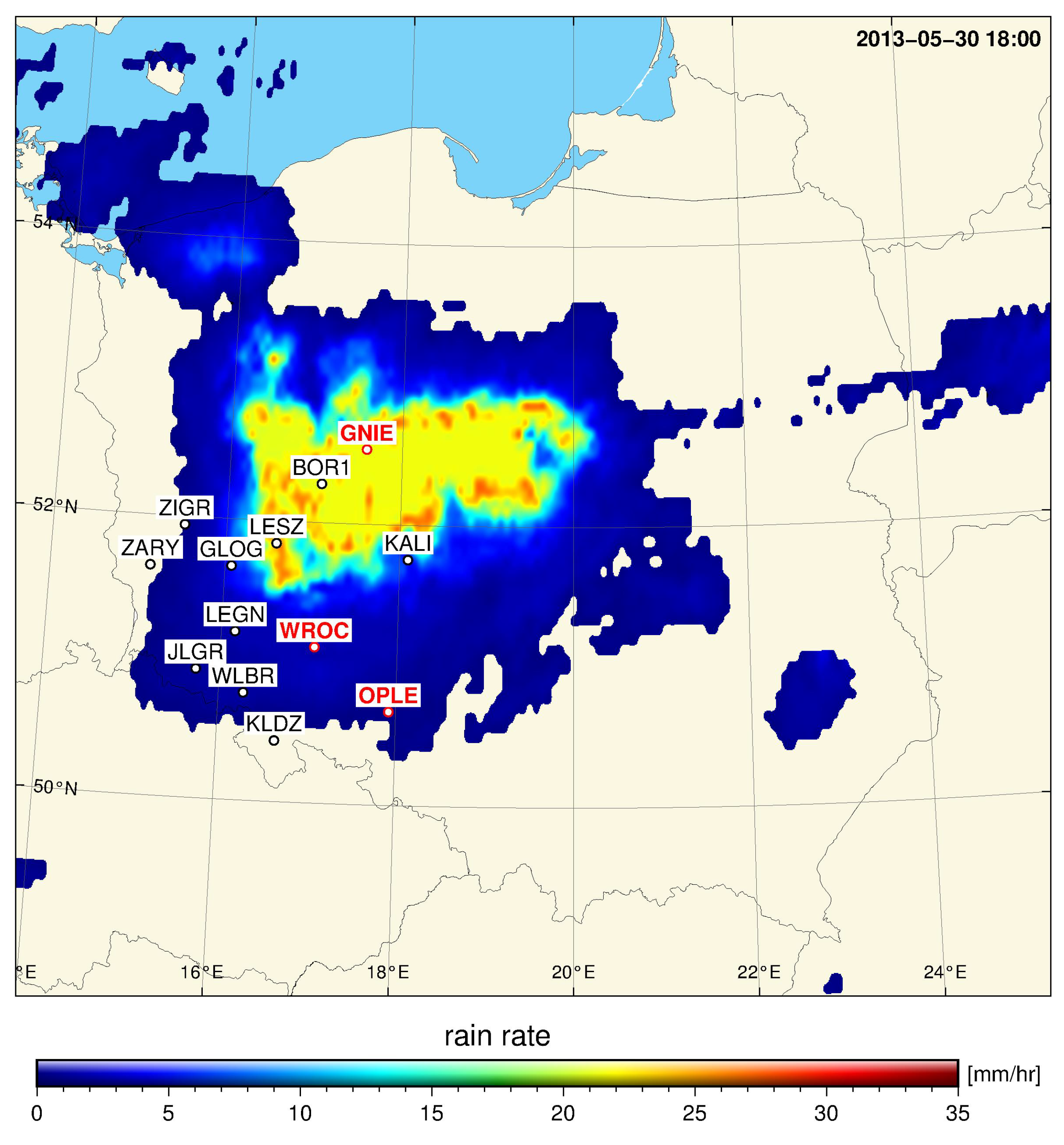
| OPLE | KALI | WROC | GNIE | ZARY | KLDZ | ZIGR | |
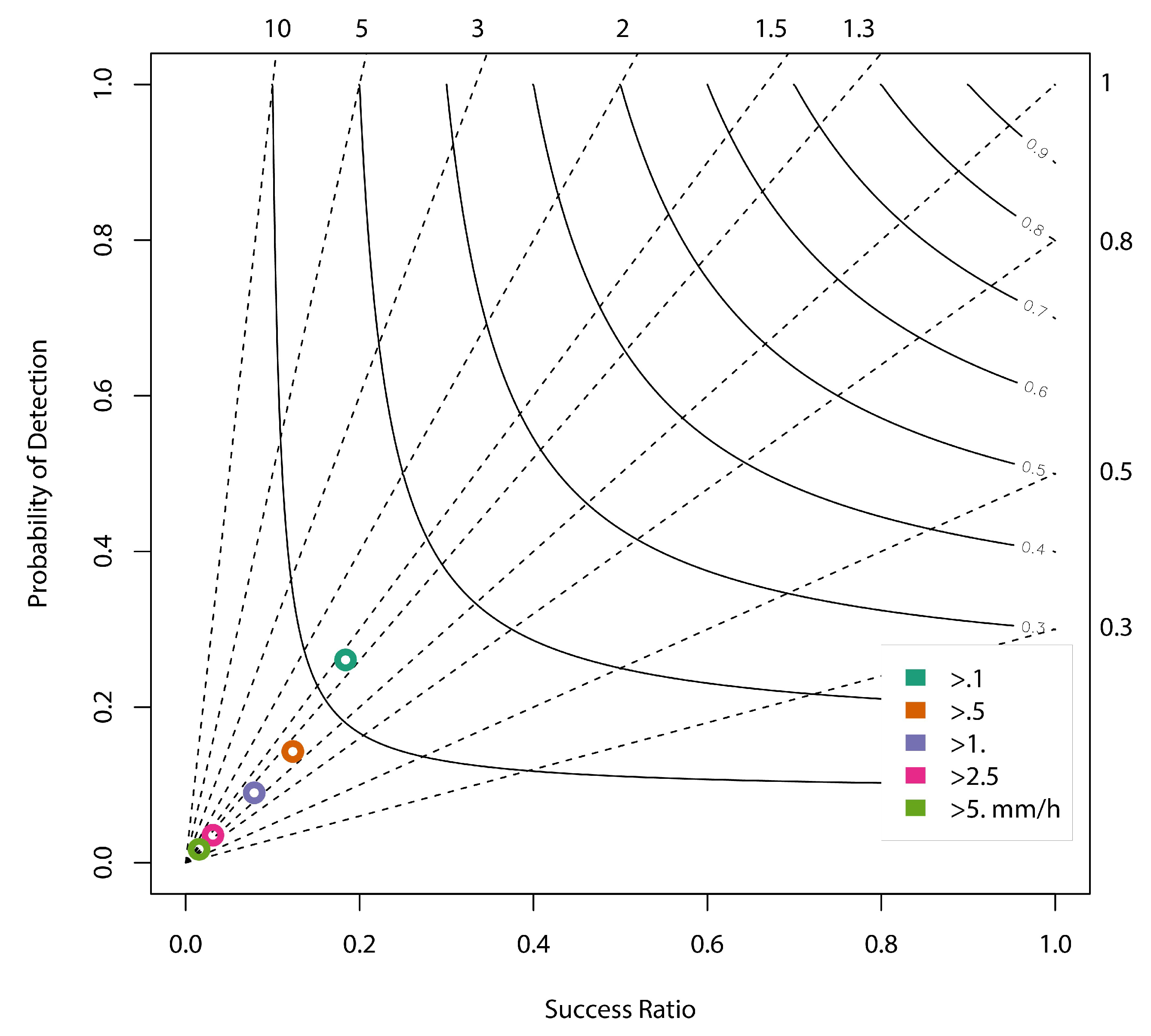
| CT | 0.25 | 0.31 | 0.37 | 0.37 | 0.38 | 0.39 | 0.40 |
| MPE > 0.01 | 0.35 | 0.05 | 0.07 | 0.10 | 0.02 | 0.46 | −0.03 |
| MPE > 2.50 | 0.68 | 0.36 | 0.20 | 0.19 | −0.48 | 0.84 | 0.22 |
| WLBR | GLOG | BOR1 | LESZ | LEGN | JLGR | ||
| CT | 0.40 | 0.41 | 0.41 | 0.41 | 0.42 | 0.43 | 0.38 |
| MPE > 0.01 | 0.12 | −0.05 | −0.19 | 0.08 | 0.49 | −0.23 | 0.10 |
| MPE > 2.50 | 0.01 | −0.21 | 0.13 | 0.07 | 0.70 | - | 0.28 |
© 2018 by the authors. Licensee MDPI, Basel, Switzerland. This article is an open access article distributed under the terms and conditions of the Creative Commons Attribution (CC BY) license (http://creativecommons.org/licenses/by/4.0/).
Share and Cite
Hordyniec, P.; Kapłon, J.; Rohm, W.; Kryza, M. Residuals of Tropospheric Delays from GNSS Data and Ray-Tracing as a Potential Indicator of Rain and Clouds. Remote Sens. 2018, 10, 1917. https://doi.org/10.3390/rs10121917
Hordyniec P, Kapłon J, Rohm W, Kryza M. Residuals of Tropospheric Delays from GNSS Data and Ray-Tracing as a Potential Indicator of Rain and Clouds. Remote Sensing. 2018; 10(12):1917. https://doi.org/10.3390/rs10121917
Chicago/Turabian StyleHordyniec, Paweł, Jan Kapłon, Witold Rohm, and Maciej Kryza. 2018. "Residuals of Tropospheric Delays from GNSS Data and Ray-Tracing as a Potential Indicator of Rain and Clouds" Remote Sensing 10, no. 12: 1917. https://doi.org/10.3390/rs10121917
APA StyleHordyniec, P., Kapłon, J., Rohm, W., & Kryza, M. (2018). Residuals of Tropospheric Delays from GNSS Data and Ray-Tracing as a Potential Indicator of Rain and Clouds. Remote Sensing, 10(12), 1917. https://doi.org/10.3390/rs10121917