Analysis of the Development of an Erosion Gully in an Open-Pit Coal Mine Dump During a Winter Freeze-Thaw Cycle by Using Low-Cost UAVs


Abstract
:
1. Introduction
2. Materials and Methods
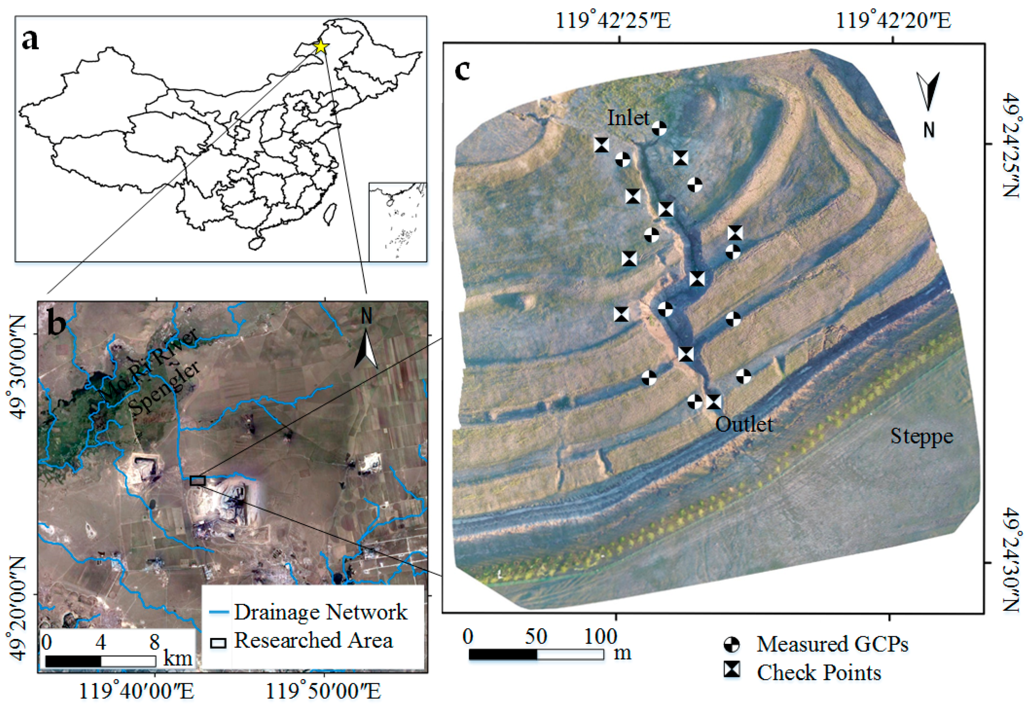
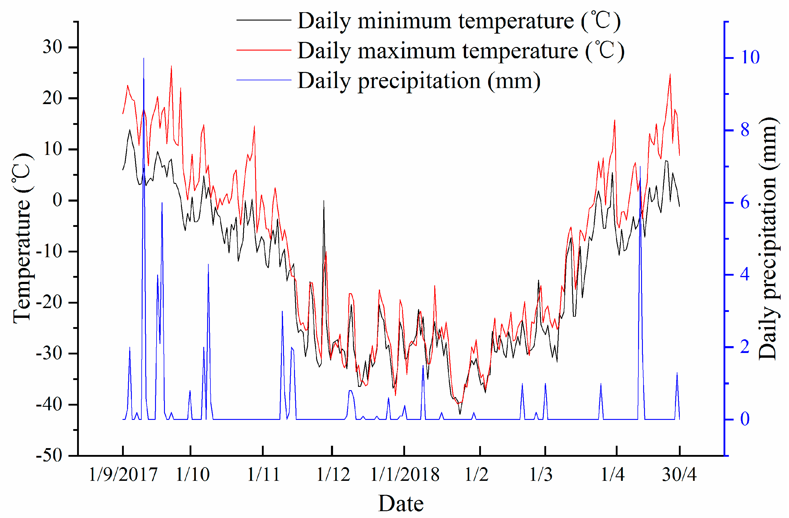
2.1. The Study Area
2.2. Data Acquisition and Processing
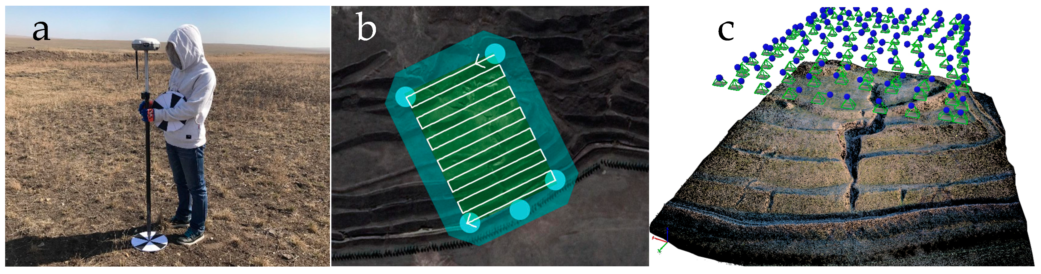
2.2.1. The Reference System
2.2.2. UAV Imaging Surveys
2.2.3. Photogrammetric Post-Processing
2.2.4. Computation of Soil Erosion and Deposition
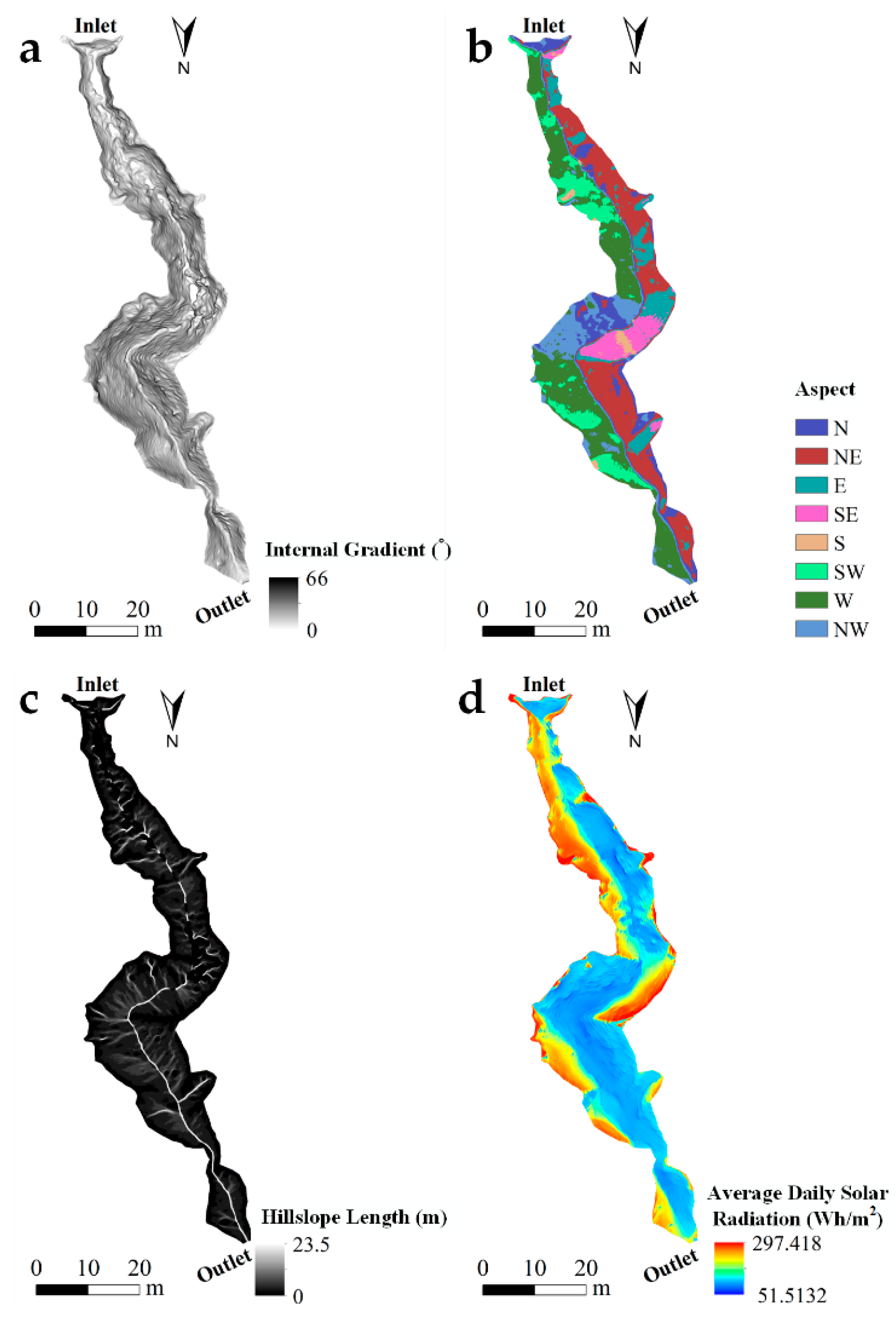
2.2.5. Geomorphometry
3. Results
3.1. Accuracy of the Techniques
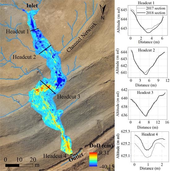
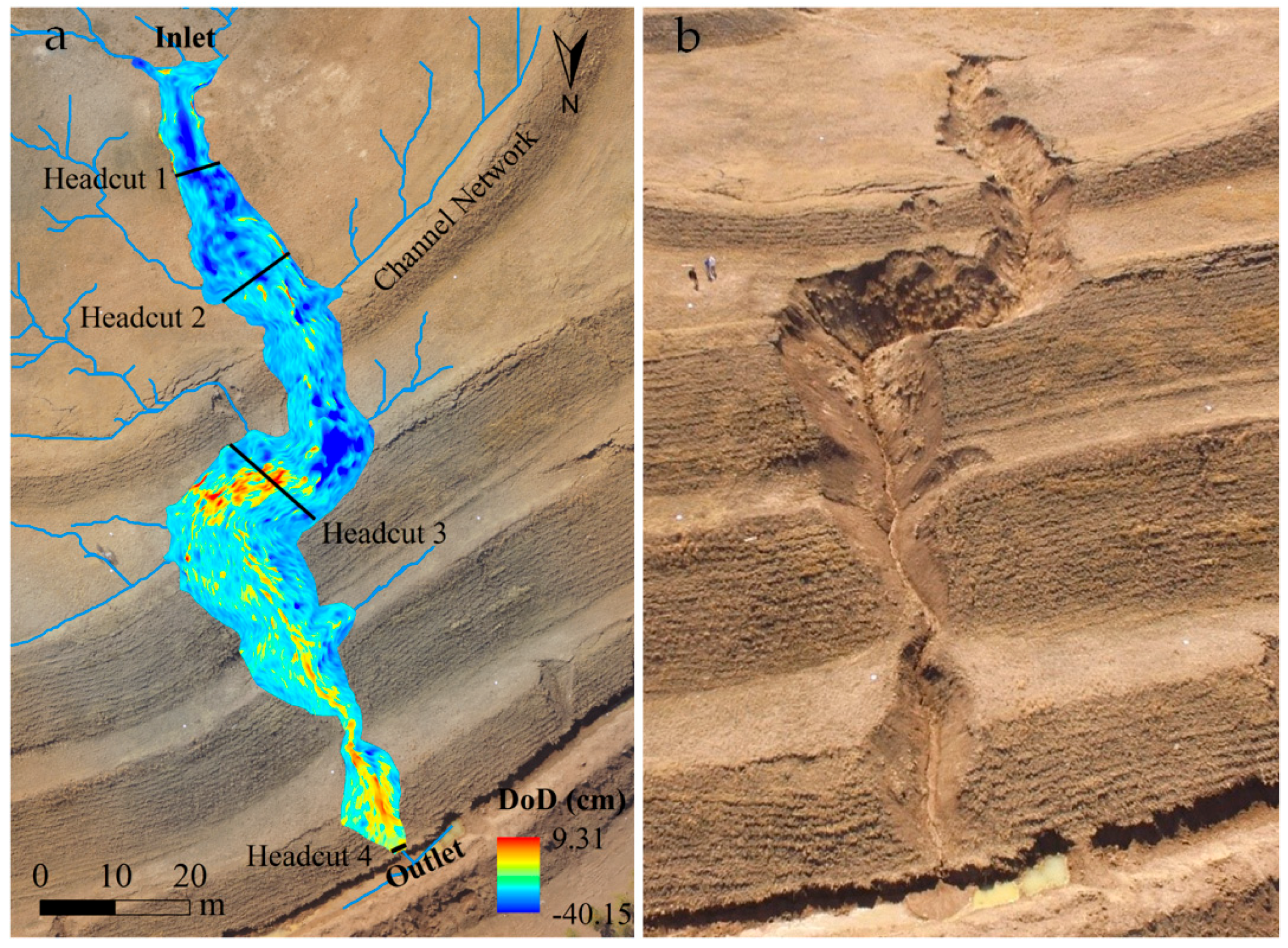
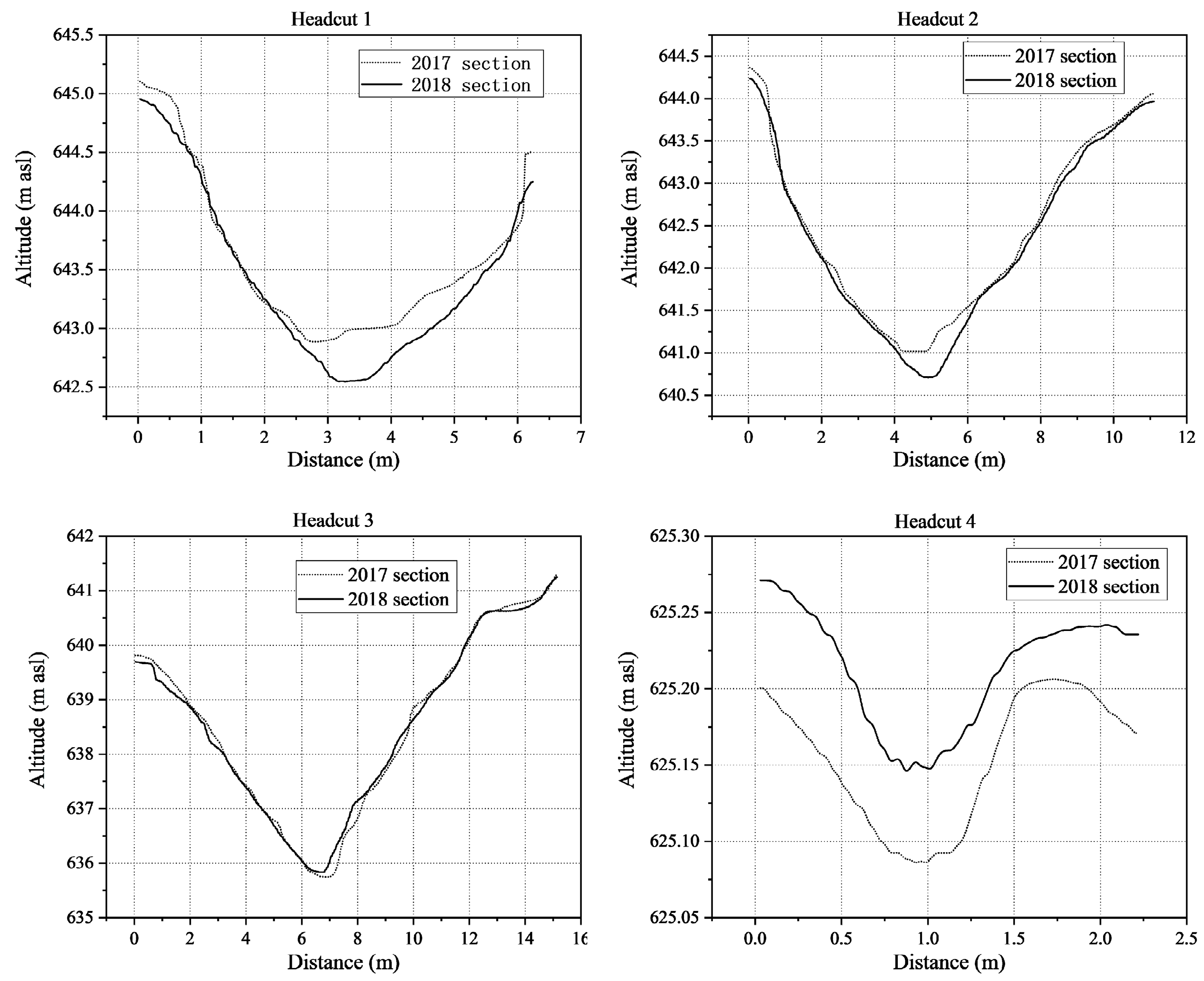
3.2. Characteristic Parameter Extraction
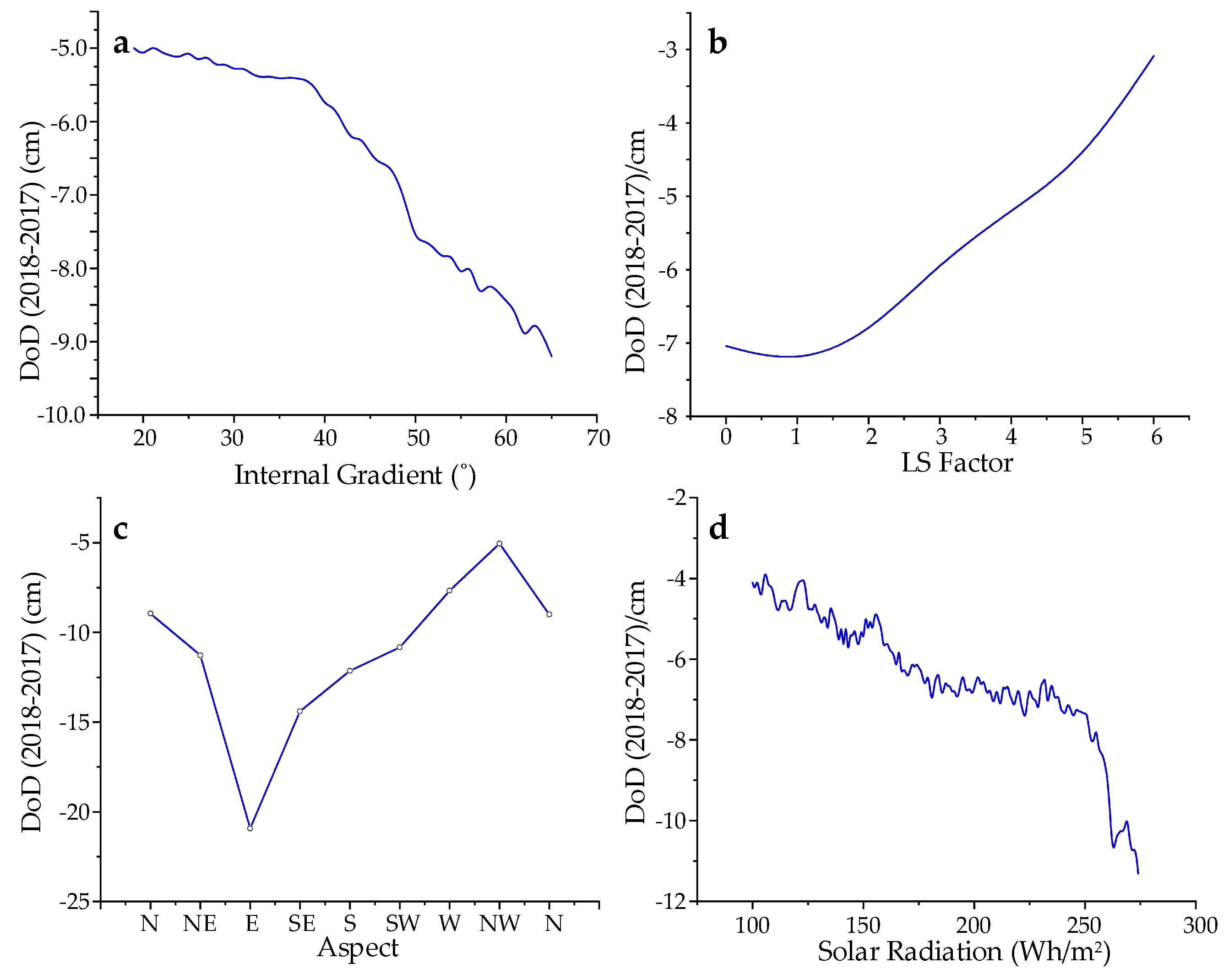
3.3. Relation between Geomorphometry and Geomorphic Changes
3.4. Correlations between Explanatory Factors
4. Discussion
4.1. The Quality of UAV-Based Topographic Surveys
4.2. Relationships between Topographic Changes and Geomorphometric Parameters
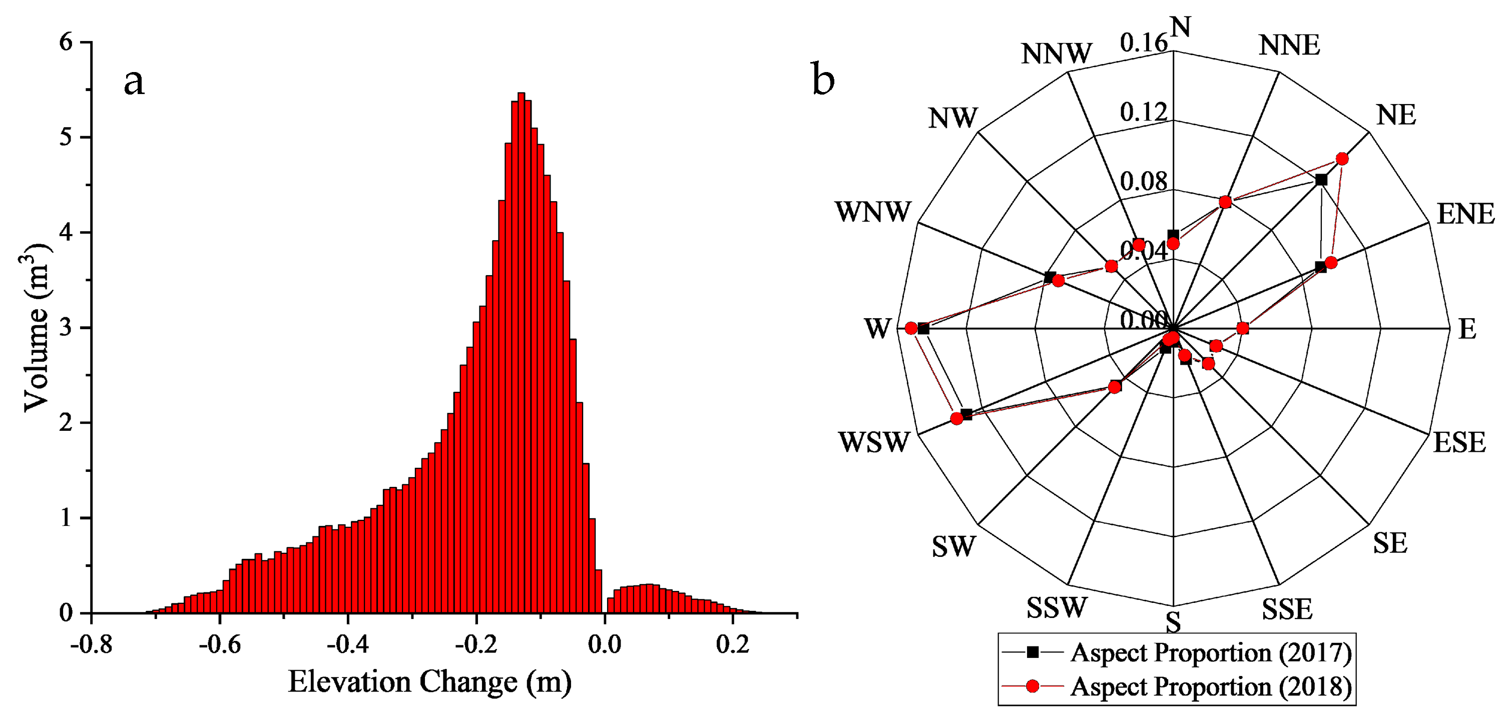
4.2.1. Distribution of Erosion/Deposition
4.2.2. Construction of the Erosion Rate Model for Different Slopes
5. Conclusions
Author Contributions
Funding
Acknowledgments
Conflicts of Interest
References
- Johnsson, H.; Lundin, L.-C. Surface runoff and soil water percolation as affected by snow and soil frost. J. Hydrol. 1991, 122, 141–159. [Google Scholar] [CrossRef]
- Wang, G.; Hu, H.; Li, T. The influence of freeze–thaw cycles of active soil layer on surface runoff in a permafrost watershed. J. Hydrol. 2009, 375, 438–449. [Google Scholar] [CrossRef]
- Valenzuela, A.M.; Polo, M.J.; Moñino, A.; Herrero, J.; Losada, M.Á. Bedload dynamics and associated snowmelt influence in mountainous and semiarid alluvial rivers. Geomorphology 2014, 206, 330–342. [Google Scholar]
- Ban, Y.; Lei, T.; Chen, C.; Yin, Z.; Qian, D. Meltwater erosion process of frozen soil as affected by thawed depth under concentrated flow in high altitude and cold regions. Earth Surf. Proc. Landf. 2017, 42, 2139–2146. [Google Scholar] [CrossRef]
- Kurylyk, B.L.; MacQuarrie, K.T.; McKenzie, J.M. Climate change impacts on groundwater and soil temperatures in cold and temperate regions: Implications, mathematical theory, and emerging simulation tools. Earth Sci. Rev. 2014, 138, 313–334. [Google Scholar] [CrossRef]
- Wu, Y.; Ouyang, W.; Hao, Z.; Yang, B.; Wang, L. Snowmelt water drives higher soil erosion than rainfall water in a mid-high latitude upland watershed. J. Hydrol. 2018, 556, 438–448. [Google Scholar] [CrossRef]
- Kværnø, S.H.; Øygarden, L. The influence of freeze–thaw cycles and soil moisture on aggregate stability of three soils in Norway. Catena 2006, 67, 175–182. [Google Scholar] [CrossRef]
- Xu, J.; Wang, Z.-Q.; Ren, J.-W.; Wang, S.-H.; Jin, L. Mechanism of slope failure in loess terrains during spring thawing. J. Mt. Sci. 2018, 15, 845–858. [Google Scholar] [CrossRef]
- Zegeye, A.D.; Langendoen, E.J.; Guzman, C.D.; Dagnew, D.C.; Amare, S.D.; Tilahun, S.A.; Steenhuis, T.S. Gullies, a critical link in landscape soil loss: A case study in the subhumid highlands of Ethiopia. Land Degrad. Dev. 2018, 29, 1222–1232. [Google Scholar] [CrossRef]
- Eltner, A.; Maas, H.-G.; Faust, D. Soil micro-topography change detection at hillslopes in fragile Mediterranean landscapes. Geoderma 2018, 313, 217–232. [Google Scholar] [CrossRef]
- Shi, X.S.; Herle, I.; Wood, D.M. A consolidation model for lumpy composite soils in open-pit mining. Géotechnique 2018, 68, 189–204. [Google Scholar] [CrossRef]
- Liu, X.; Cao, Y.; Bai, Z.; Wang, J.; Zhou, W. Evaluating relationships between soil chemical properties and vegetation cover at different slope aspects in a reclaimed dump. Environ. Earth Sci. 2017, 76, 805. [Google Scholar] [CrossRef]
- Sanchez, C.E.; Wood, M.K. Infiltration rates and erosion associated with reclaimed coal mine spoils in west central New Mexico. Landsc. Urban Plan. 1989, 17, 151–168. [Google Scholar] [CrossRef]
- Martín-Moreno, C.; Martín Duque, J.F.; Nicolau Ibarra, J.M.; Hernando Rodríguez, N.; Sanz Santos, M.Á.; Sánchez Castillo, L. Effects of Topography and Surface Soil Cover on Erosion for Mining Reclamation: The Experimental Spoil Heap at El Machorro Mine (Central Spain). Land Degrad. Dev. 2016, 27, 145–159. [Google Scholar] [CrossRef]
- Zapico, I.; Laronne, J.B.; Martín-Moreno, C.; Martín-Duque, J.F.; Ortega, A.; Sánchez-Castillo, L. Baseline to Evaluate Off-Site Suspended Sediment-Related Mining Effects in the Alto Tajo Natural Park, Spain. Land Degrad. Dev. 2017, 28, 232–242. [Google Scholar] [CrossRef]
- Haregeweyn, N.; Poesen, J.; Nyssen, J.; De Wit, J.; Haile, M.; Govers, G.; Deckers, S. Reservoirs in Tigray (Northern Ethiopia): Characteristics and sediment deposition problems. Land Degrad. Dev. 2006, 17, 211–230. [Google Scholar] [CrossRef]
- Poesen, J.; Nachtergaele, J.; Verstraeten, G.; Valentin, C. Gully erosion and environmental change: Importance and research needs. Catena 2003, 50, 91–133. [Google Scholar] [CrossRef]
- Tamene, L.; Park, S.; Dikau, R.; Vlek, P. Analysis of factors determining sediment yield variability in the highlands of northern Ethiopia. Geomorphology 2006, 76, 76–91. [Google Scholar] [CrossRef]
- Tian, P.; Xu, X.; Pan, C.; Hsu, K.; Yang, T. Impacts of rainfall and inflow on rill formation and erosion processes on steep hillslopes. J. Hydrol. 2017, 548, 24–39. [Google Scholar] [CrossRef]
- Rowntree, K. Morphological characteristics of gully networks and their relationship to host materials, Baringo District, Kenya. GeoJournal 1991, 23, 19–27. [Google Scholar] [CrossRef]
- Nadal-Romero, E.; Petrlic, K.; Verachtert, E.; Bochet, E.; Poesen, J.; Nadal-Romero, E. Effects of slope angle and aspect on plant cover and species richness in a humid Mediterranean badland. Earth Surf. Process. Landf. 2014, 39, 1705–1716. [Google Scholar] [CrossRef]
- Evans, R.; Collins, A.; Zhang, Y.; Foster, I.; Boardman, J.; Sint, H.; Lee, M.; Griffith, B. A comparison of conventional and 137 Cs-based estimates of soil erosion rates on arable and grassland across lowland England and Wales. Earth Sci. Rev. 2017, 173, 49–64. [Google Scholar] [CrossRef]
- Diwediga, B.; Le, Q.B.; Agodzo, S.K.; Tamene, L.D.; Wala, K. Modelling soil erosion response to sustainable landscape management scenarios in the Mo River Basin (Togo, West Africa). Sci. Total. Environ. 2018, 625, 1309–1320. [Google Scholar] [CrossRef] [PubMed]
- Wischmeier, W.H.; Smith, D.D. Predicting Rainfall Erosion Losses—A Guide to Conservation Planning; Agricultural Handbook No. 537; US Department of Agriculture: Washington, DC, USA, 1978.
- Renard, K.G.; Foster, G.R.; Weesies, G.A.; Mccool, D.K.; Yoder, D.C. Predicting Soil Erosion by Water: A Guide to Conservation Planning with the Revised Universal Soil Loss Equation (RUSLE); Agricultural Handbook No. 703; US Department of Agriculture: Washington, DC, USA, 1997.
- Tucker, G.E.; Hancock, G.R. Modelling landscape evolution. Earth Surf. Proc. Landf. 2010, 35, 28–50. [Google Scholar] [CrossRef]
- Glendell, M.; McShane, G.; Farrow, L.; James, M.R.; Quinton, J.; Anderson, K.; Evans, M.; Benaud, P.; Rawlins, B.; Morgan, D.; et al. Testing the utility of structure-from-motion photogrammetry reconstructions using small unmanned aerial vehicles and ground photography to estimate the extent of upland soil erosion. Earth Surf. Proc. Landf. 2017, 42, 1860–1871. [Google Scholar] [CrossRef]
- Di Stefano, C.; Ferro, V.; Palmeri, V.; Pampalone, V. Measuring rill erosion using structure from motion: A plot experiment. Catena 2017, 156, 383–392. [Google Scholar] [CrossRef]
- Gonzales-Inca, C.; Valkama, P.; Lill, J.-O.; Slotte, J.; Hietaharju, E.; Uusitalo, R. Spatial modeling of sediment transfer and identification of sediment sources during snowmelt in an agricultural watershed in boreal climate. Sci. Total. Environ. 2018, 612, 303–312. [Google Scholar] [CrossRef]
- Ragettli, S.; Pellicciotti, F.; Immerzeel, W.W.; Miles, E.S.; Petersen, L.; Heynen, M.; Shea, J.M.; Stumm, D.; Joshi, S.; Shrestha, A. Unraveling the hydrology of a Himalayan catchment through integration of high resolution in situ data and remote sensing with an advanced simulation model. Adv. Water Resour. 2015, 78, 94–111. [Google Scholar] [CrossRef]
- D’Oleire-Oltmanns, S.; Marzolff, I.; Peter, K.D.; Ries, J.B. Unmanned Aerial Vehicle (UAV) for Monitoring Soil Erosion in Morocco. Remote Sens. 2012, 4, 3390–3416. [Google Scholar] [CrossRef] [Green Version]
- Tonkin, T.; Midgley, N.; Graham, D.; Labadz, J.; Midgley, N.; Graham, D. The potential of small unmanned aircraft systems and structure-from-motion for topographic surveys: A test of emerging integrated approaches at Cwm Idwal, North Wales. Geomorphology 2014, 226, 35–43. [Google Scholar] [CrossRef] [Green Version]
- Doi, H.; Akamatsu, Y.; Watanabe, Y.; Goto, M.; Inui, R.; Katano, I.; Nagano, M.; Takahara, T.; Minamoto, T. Water sampling for environmental DNA surveys by using an unmanned aerial vehicle. Limnol. Oceanogr. Methods 2017, 15, 939–944. [Google Scholar] [CrossRef]
- Shang, S.; Lee, Z.; Lin, G.; Hu, C.; Shi, L. Sensing an intense phytoplankton bloom in the western Taiwan Strait from radiometric measurements on a UAV. Remote Sens. Environ. 2017, 198, 85–94. [Google Scholar] [CrossRef]
- Gonçalves, J.; Henriques, R. UAV photogrammetry for topographic monitoring of coastal areas. ISPRS J. Photogramm. Remote Sens. 2015, 104, 101–111. [Google Scholar] [CrossRef]
- Romboli, Y.; Di Gennaro, S.F.; Mangani, S.; Buscioni, G.; Matese, A.; Genesio, L.; Vincenzini, M. Vine vigour modulates bunch microclimate and affects the composition of grape and wine flavonoids: An unmanned aerial vehicle approach in a Sangiovese vineyard in Tuscany. Aust. J. Grape Wine Res. 2017, 23, 368–377. [Google Scholar] [CrossRef]
- Immerzeel, W.; Kraaijenbrink, P.; Shea, J.; Shrestha, A.; Pellicciotti, F.; Bierkens, M.; De Jong, S.; Immerzeel, W.; De Jong, S. High-resolution monitoring of Himalayan glacier dynamics using unmanned aerial vehicles. Remote Sens. Environ. 2014, 150, 93–103. [Google Scholar] [CrossRef]
- Hu, S.; Qiu, H.; Wang, X.; Gao, Y.; Wang, N.; Wu, J.; Yang, D.; Cao, M. Acquiring high-resolution topography and performing spatial analysis of loess landslides by using low-cost UAVs. Landslides 2018, 15, 593–612. [Google Scholar] [CrossRef]
- Martínez-Martínez, J.; Corbí, H.; Martin-Rojas, I.; Baeza-Carratalá, J.; Giannetti, A. Stratigraphy, petrophysical characterization and 3D geological modelling of the historical quarry of Nueva Tabarca island (western Mediterranean): Implications on heritage conservation. Eng. Geol. 2017, 231, 88–99. [Google Scholar] [CrossRef] [Green Version]
- Hackl, J.; Adey, B.T.; Woźniak, M.; Schümperlin, O. Use of Unmanned Aerial Vehicle Photogrammetry to Obtain Topographical Information to Improve Bridge Risk Assessment. J. Infrastruct. Syst. 2018, 24, 4017041. [Google Scholar] [CrossRef]
- Niethammer, U.; James, M.; Rothmund, S.; Travelletti, J.; Joswig, M. UAV-based remote sensing of the Super-Sauze landslide: Evaluation and results. Eng. Geol. 2012, 128, 2–11. [Google Scholar] [CrossRef]
- Hugenholtz, C.H.; Whitehead, K.; Brown, O.W.; Barchyn, T.E.; Moorman, B.J.; LeClair, A.; Riddell, K.; Hamilton, T. Geomorphological mapping with a small unmanned aircraft system (sUAS): Feature detection and accuracy assessment of a photogrammetrically-derived digital terrain model. Geomorphology 2013, 194, 16–24. [Google Scholar] [CrossRef] [Green Version]
- Giménez, R.; Marzolff, I.; Campo, M.A.; Seeger, M.; Ries, J.B.; Casalí, J.; Álvarez-Mozos, J. Accuracy of high-resolution photogrammetric measurements of gullies with contrasting morphology. Earth Surf. Proc. Landf. 2009, 34, 1915–1926. [Google Scholar] [CrossRef]
- Peter, K.D.; D’Oleire-Oltmanns, S.; Ries, J.B.; Marzolff, I.; Hssaine, A.A. Soil erosion in gully catchments affected by land-levelling measures in the Souss Basin, Morocco, analysed by rainfall simulation and UAV remote sensing data. Catena 2014, 113, 24–40. [Google Scholar] [CrossRef]
- Wang, R.; Zhang, S.; Pu, L.; Yang, J.; Yang, C.; Chen, J.; Guan, C.; Wang, Q.; Chen, D.; Fu, B.; et al. Gully Erosion Mapping and Monitoring at Multiple Scales Based on Multi-Source Remote Sensing Data of the Sancha River Catchment, Northeast China. ISPRS Int. J. Geo-Inf. 2016, 5, 200. [Google Scholar] [CrossRef]
- Li, J.; Zheng, Z.; Xie, H.; Zhao, N.; Gao, Y. Increased soil nutrition and decreased light intensity drive species loss after eight years grassland enclosures. Sci. Rep. 2017, 7, 44525. [Google Scholar] [CrossRef] [PubMed] [Green Version]
- Ban, Y.; Lei, T.; Liu, Z.; Chen, C. Comparative study of erosion processes of thawed and non-frozen soil by concentrated meltwater flow. Catena 2017, 148, 153–159. [Google Scholar] [CrossRef]
- James, M.R.; Robson, S. Mitigating systematic error in topographic models derived from UAV and ground-based image networks. Earth Surf. Process. Landf. 2014, 39, 1413–1420. [Google Scholar] [CrossRef] [Green Version]
- Ruzgiene, B.; Berteška, T.; Gečyte, S.; Jakubauskienė, E.; Aksamitauskas, V.Č. The surface modelling based on UAV Photogrammetry and qualitative estimation. Measurement 2015, 73, 619–627. [Google Scholar] [CrossRef]
- Zahawi, R.A.; Dandois, J.P.; Holl, K.D.; Nadwodny, D.; Reid, J.L.; Ellis, E.C. Using lightweight unmanned aerial vehicles to monitor tropical forest recovery. Boil. Conserv. 2015, 186, 287–295. [Google Scholar] [CrossRef] [Green Version]
- Eltner, A.; Schneider, D. Analysis of Different Methods for 3D Reconstruction of Natural Surfaces from Parallel-Axes UAV Images. Photogramm. Rec. 2015, 30, 279–299. [Google Scholar] [CrossRef]
- Taddia, Y.; Corbau, C.; Zambello, E.; Pellegrinelli, A. UAVs for Structure-From-Motion Coastal Monitoring: A Case Study to Assess the Evolution of Embryo Dunes over a Two-Year Time Frame in the Po River Delta, Italy. Sensors 2019, 19, 1717. [Google Scholar] [CrossRef]
- Taylor, J.R.; Semon, M.D.; Pribram, J.K. POST-USE REVIEW: An Introduction to Error Analysis: The Study of Uncertainties in Physical Measurements. Am. J. Phys. 1983, 51, 191–192. [Google Scholar] [CrossRef]
- Brasington, J.; Langham, J.; Rumsby, B. Methodological sensitivity of morphometric estimates of coarse fluvial sediment transport. Geomorphology 2003, 53, 299–316. [Google Scholar] [CrossRef]
- Brasington, J.; Rumsby, B.T.; McVey, R.A. Monitoring and modelling morphological change in a braided gravel-bed river using high resolution GPS-based survey. Earth Surf. Process. Landf. 2000, 25, 973–990. [Google Scholar] [CrossRef]
- Van Remortel, R.D.; Hamilton, M.E.; Hickey, R.J. Estimating the LS Factor for RUSLE through Iterative Slope Length Processing of Digital Elevation Data within Arclnfo Grid. Cartography 2001, 30, 27–35. [Google Scholar] [CrossRef]
- Fu, P.; Rich, P.M. A geometric solar radiation model with applications in agriculture and forestry. Comput. Electron. Agric. 2002, 37, 25–35. [Google Scholar] [CrossRef]
- Rich, P.M.; Dubayah, R.O.; Hetrick, W.A.; Saving, S.C. Using viewshed models to calculate intercepted solar radiation: Applications in ecology. Am. Soc. Photogramm. Remote Sens. Tech. Pap. 1994, 524–529. Available online: http://www.professorpaul.com/publications/rich_et_al_1994_asprs.pdf (accessed on 4 June 2019).
- Cook, K.L. An evaluation of the effectiveness of low-cost UAVs and structure from motion for geomorphic change detection. Geomorphology 2017, 278, 195–208. [Google Scholar] [CrossRef]
- Smith, M.W.; Vericat, D. From experimental plots to experimental landscapes: Topography, erosion and deposition in sub-humid badlands from Structure-from-Motion photogrammetry. Earth Surf. Proc. Landf. 2015, 40, 1656–1671. [Google Scholar] [CrossRef]
- Kaiser, A.; Neugirg, F.; Rock, G.; Muller, C.; Haas, F.; Ries, J.; Schmidt, J. Small-Scale Surface Reconstruction and Volume Calculation of Soil Erosion in Complex Moroccan Gully Morphology Using Structure from Motion. Remote Sens. 2014, 6, 7050–7080. [Google Scholar] [CrossRef] [Green Version]
- Cawood, A.J.; Howell, J.A.; Butler, R.W.; Totake, Y.; Bond, C.E. LiDAR, UAV or compass-clinometer? Accuracy, coverage and the effects on structural models. J. Struct. Geol. 2017, 98, 67–82. [Google Scholar] [CrossRef]
- James, L.A.; Hodgson, M.E.; Ghoshal, S.; Latiolais, M.M.; James, A. Geomorphic change detection using historic maps and DEM differencing: The temporal dimension of geospatial analysis. Geomorphology 2012, 137, 181–198. [Google Scholar] [CrossRef]
- Young, R.A.; Mutchler, C.K. Effect of slope shape on erosion and runoff. Trans. ASAE 1969, 12, 231–233. [Google Scholar]
- Young, R.A.; Mutchler, C.K. Soil movement on irregular slopes. Water Resour. Res. 1969, 5, 1084–1089. [Google Scholar] [CrossRef]
- Di Stefano, C.; Ferro, V.; Porto, P.; Tusa, G. Slope curvature influence on soil erosion and deposition processes. Water Resour. Res. 2000, 36, 607–617. [Google Scholar] [CrossRef]
- Li, Z.; Wei, X.L.; Wang, X.J.; Han, Q.H. Study of soil temperature and thaw depth during spring in Jilin Province. Chin. J. Soil Sci. 2016, 47, 334–338. [Google Scholar]
- King, C. The uniformitarian nature of hillslopes. Trans. Edinb. Geol. Soc. 1957, 17, 81–102. [Google Scholar] [CrossRef]
- Zachar, D. Soil Erosion: Developments in Soil Science; Elsivier Scientific: New York, NY, USA, 1982; pp. 281–300. [Google Scholar]


| Soil Type | Particle Size Distribution (%) | (I/S) (%) | Illit (%) | Kaolinite (%) | pH | Soil Moisture | ||
|---|---|---|---|---|---|---|---|---|
| 0.05~2 mm | 0.002~0.05 mm | <0.002 mm | ||||||
| clay | 11.5 ± 0.18 | 77.0 ± 0.31 | 4.5 ± 0.21 | 49.4 ± 0.47 | 2.7 ± 0.29 | 1.6 ± 0.20 | 8.28 ± 0.21 | 5.41 ± 0.35 |
| October 2017 | May 2018 | |
|---|---|---|
| Aircraft | DJI Phantom 3 Pro | |
| Weight | 1280 g | |
| Maximum Flight Speed | 16 m/s | |
| Operating Temperature | 0–40 °C | |
| Flight Time | ~25 min/sortie | |
| Sensor | FC300X_3.6_4000x3000 (RGB) f/2.8 | |
| Takeoff Height Ground Level (m) | ~30 m AGL | |
| Fly height ground level (m) | 19–42 m AGL | |
| Image Forward Overlap (%) | 85% | |
| Image Side Overlap (%) | 85% | |
| Number of Images Captured | 957 | 1132 |
| Image Overlap (Num. of Images) | >9 | |
| Number of GCPs | 10 | |
| Number of Validation Points | 10 | |
| Ground Sampling Distance (GSD, cm pix−1) | ~1.8 | |
| Acquisition Date | Difference (cm) | ||||||||||||
|---|---|---|---|---|---|---|---|---|---|---|---|---|---|
| Easting | Northing | Elevation | |||||||||||
| Max | Min | Mean | RMSE | Max | Min | Mean | RMSE | Max | Min | Mean | RMSE | ||
| GCPs | October 2017 | 1.8 | −0.7 | 0.3 | 0.8 | 0.8 | −1.8 | −0.4 | 0.9 | 1.6 | −1.2 | 0.2 | 1.1 |
| May 2018 | 1 | −0.8 | 0.2 | 0.5 | 1.2 | −0.9 | 0.3 | 0.7 | 2 | −2.1 | 0.3 | 1.7 | |
| Check Points | October 2017 | 1.9 | −1.2 | 0.4 | 1.1 | 2.6 | −1.6 | 0.8 | 1.5 | 2.2 | −2.1 | 0.3 | 1.6 |
| May 2018 | 2.1 | −1.1 | 0.4 | 1.3 | 1.8 | −2.8 | −0.6 | 1.6 | 2.1 | −1.9 | 0.5 | 1.5 | |
| Gully Year | Gully Length from Inlet to Outlet (m) | Width Range (m) | Depth Range (m) | Total Gully Area (m2) | Cumulative Soil Loss (m3) |
|---|---|---|---|---|---|
| 2017 | 125.91 | 2.20~18.43 | 0.87~8.24 | 950.3 | / |
| 2018 | 126.52 | 2.22~18.51 | 0.85~8.53 | 958.4 | 111.24 |
| Internal Gradient Ranges 0°–66° | Hillslope Length | High Solar Radiation (136–296 Wh/m2) | |
|---|---|---|---|
| Soil Erosion (cm) | 0.919 ** | 0.922 ** | 0.808 ** |
© 2019 by the authors. Licensee MDPI, Basel, Switzerland. This article is an open access article distributed under the terms and conditions of the Creative Commons Attribution (CC BY) license (http://creativecommons.org/licenses/by/4.0/).
Share and Cite
Gong, C.; Lei, S.; Bian, Z.; Liu, Y.; Zhang, Z.; Cheng, W. Analysis of the Development of an Erosion Gully in an Open-Pit Coal Mine Dump During a Winter Freeze-Thaw Cycle by Using Low-Cost UAVs. Remote Sens. 2019, 11, 1356. https://doi.org/10.3390/rs11111356
Gong C, Lei S, Bian Z, Liu Y, Zhang Z, Cheng W. Analysis of the Development of an Erosion Gully in an Open-Pit Coal Mine Dump During a Winter Freeze-Thaw Cycle by Using Low-Cost UAVs. Remote Sensing. 2019; 11(11):1356. https://doi.org/10.3390/rs11111356
Chicago/Turabian StyleGong, Chuangang, Shaogang Lei, Zhengfu Bian, Ying Liu, Zhouai Zhang, and Wei Cheng. 2019. "Analysis of the Development of an Erosion Gully in an Open-Pit Coal Mine Dump During a Winter Freeze-Thaw Cycle by Using Low-Cost UAVs" Remote Sensing 11, no. 11: 1356. https://doi.org/10.3390/rs11111356