Spatial Analysis of Surface Urban Heat Islands in Four Rapidly Growing African Cities


Abstract

1. Introduction
2. Data and Methods
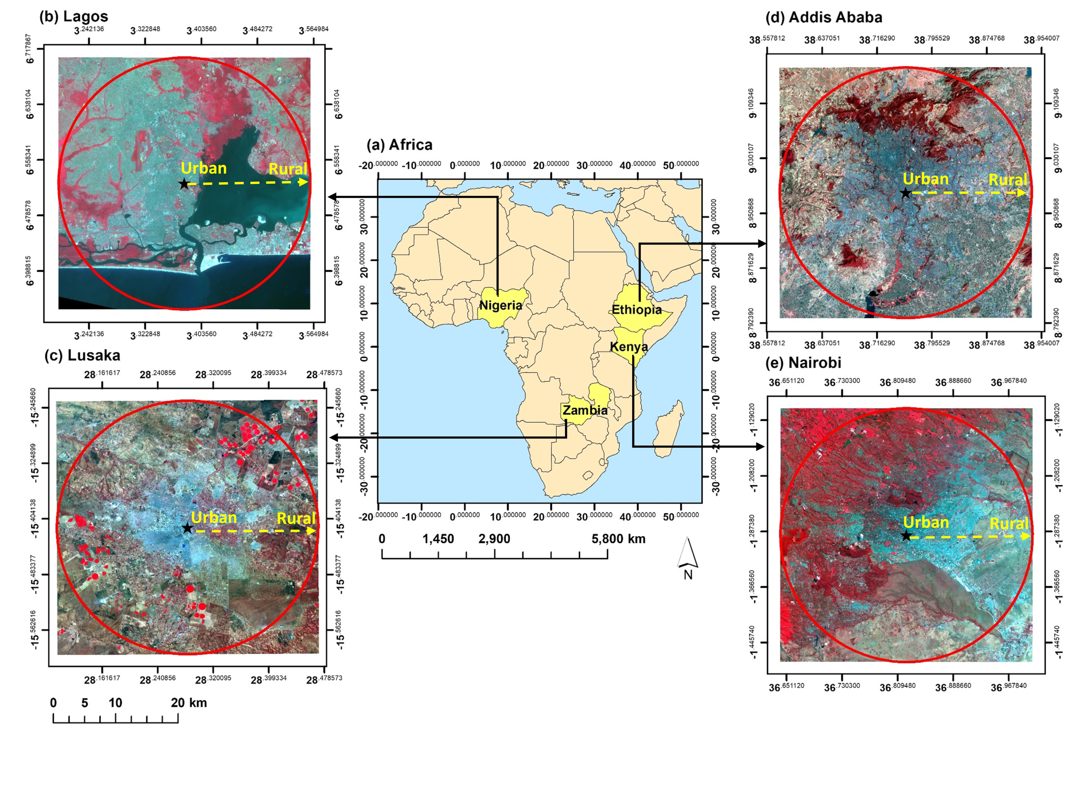
2.1. Study Areas
2.2. Satellite Data and Pre-Processing
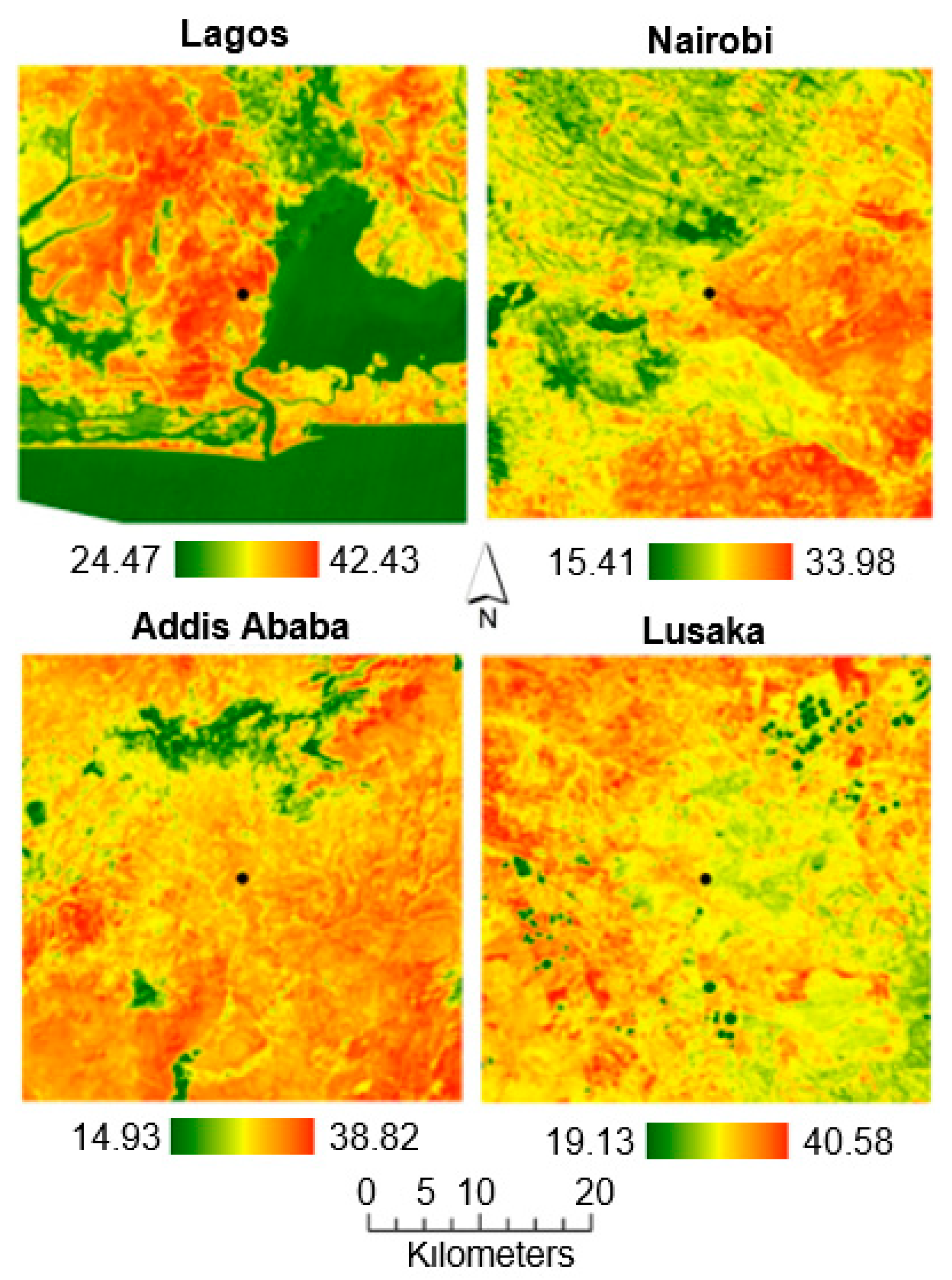
2.3. Retrieval of LST
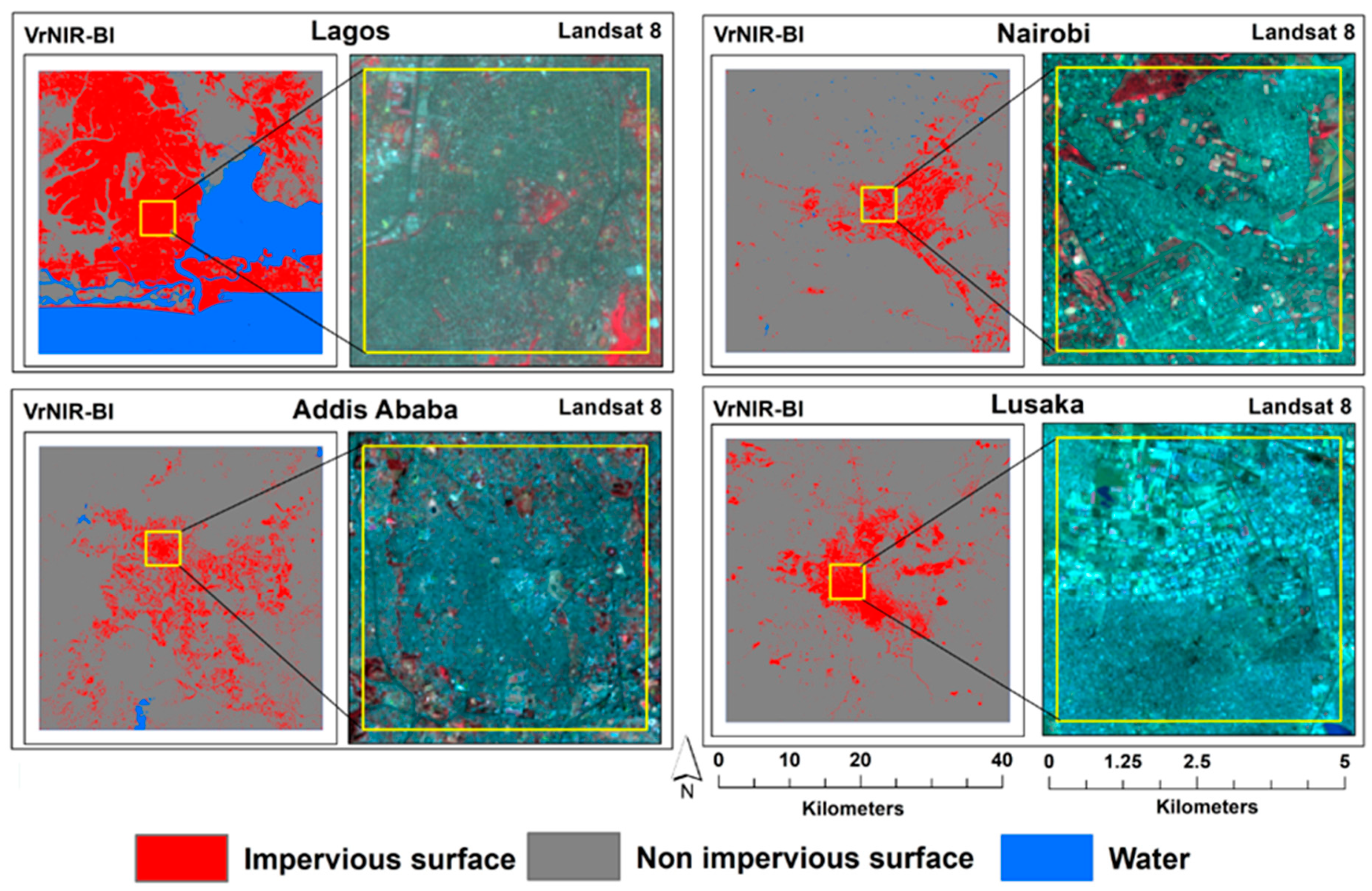
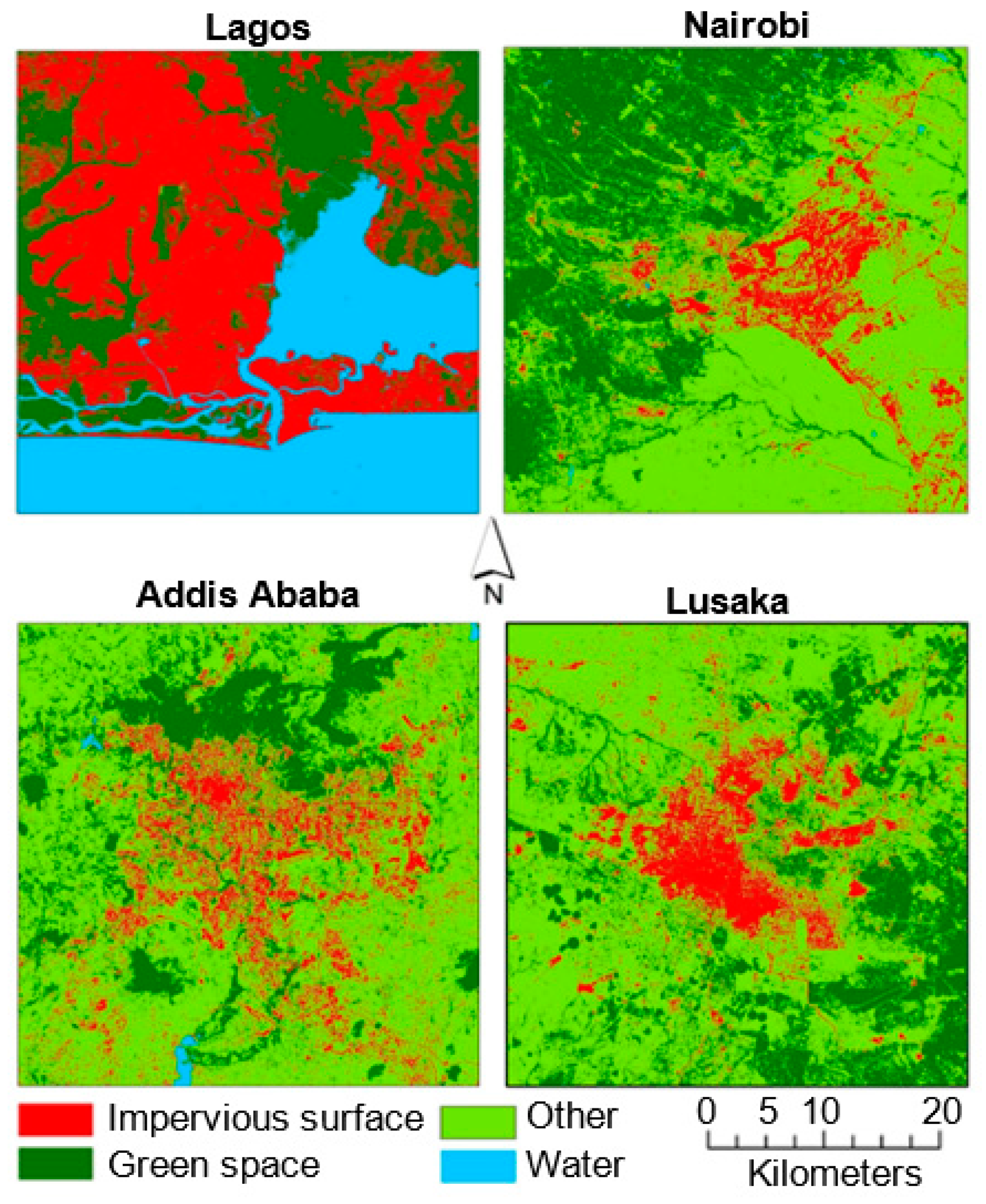
2.4. Extraction of Land Cover
2.5. Analysis of Spatial Patterns
2.5.1. Urban–Rural Gradient Analysis
2.5.2. SUHI Intensity Analysis
2.5.3. Urban Landscape Metrics Analysis
2.5.4. Statistical Analysis
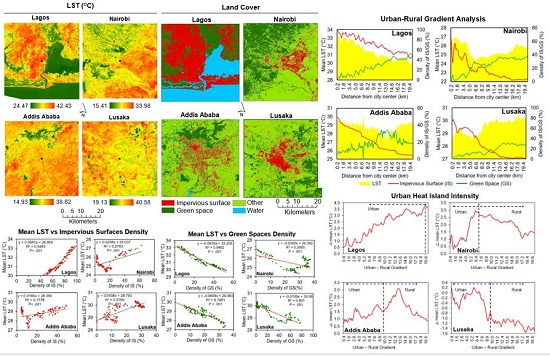
3. Results
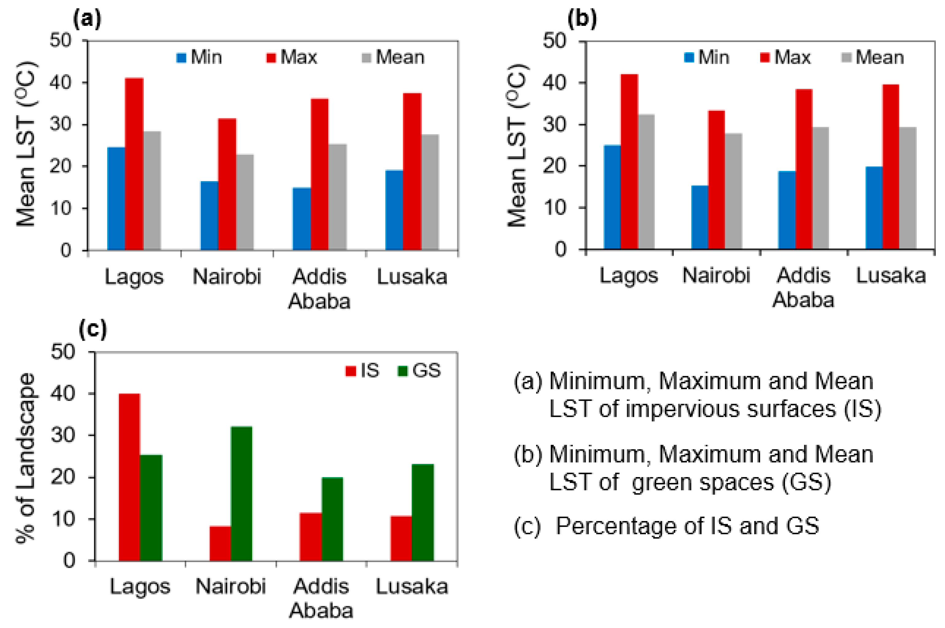
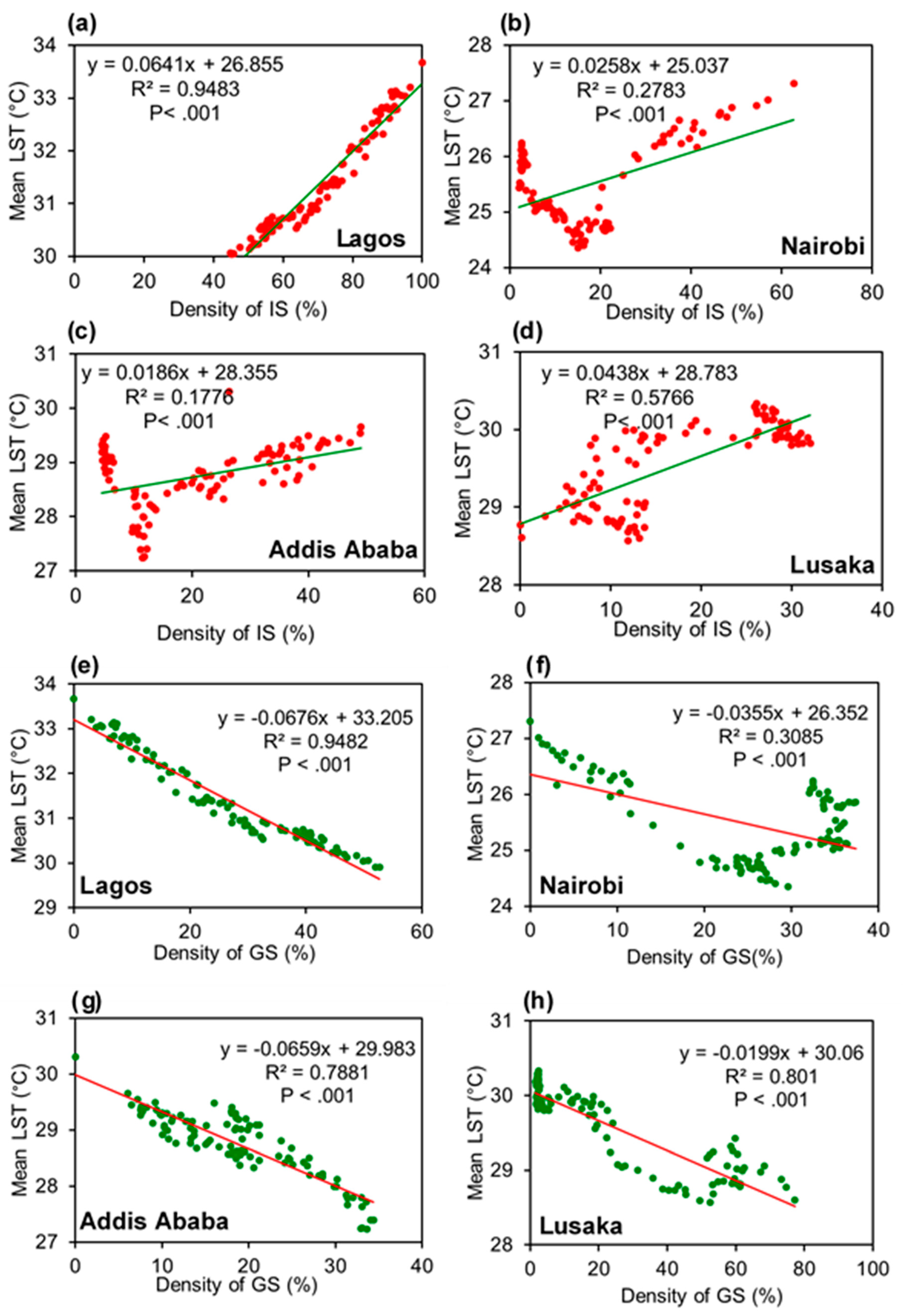
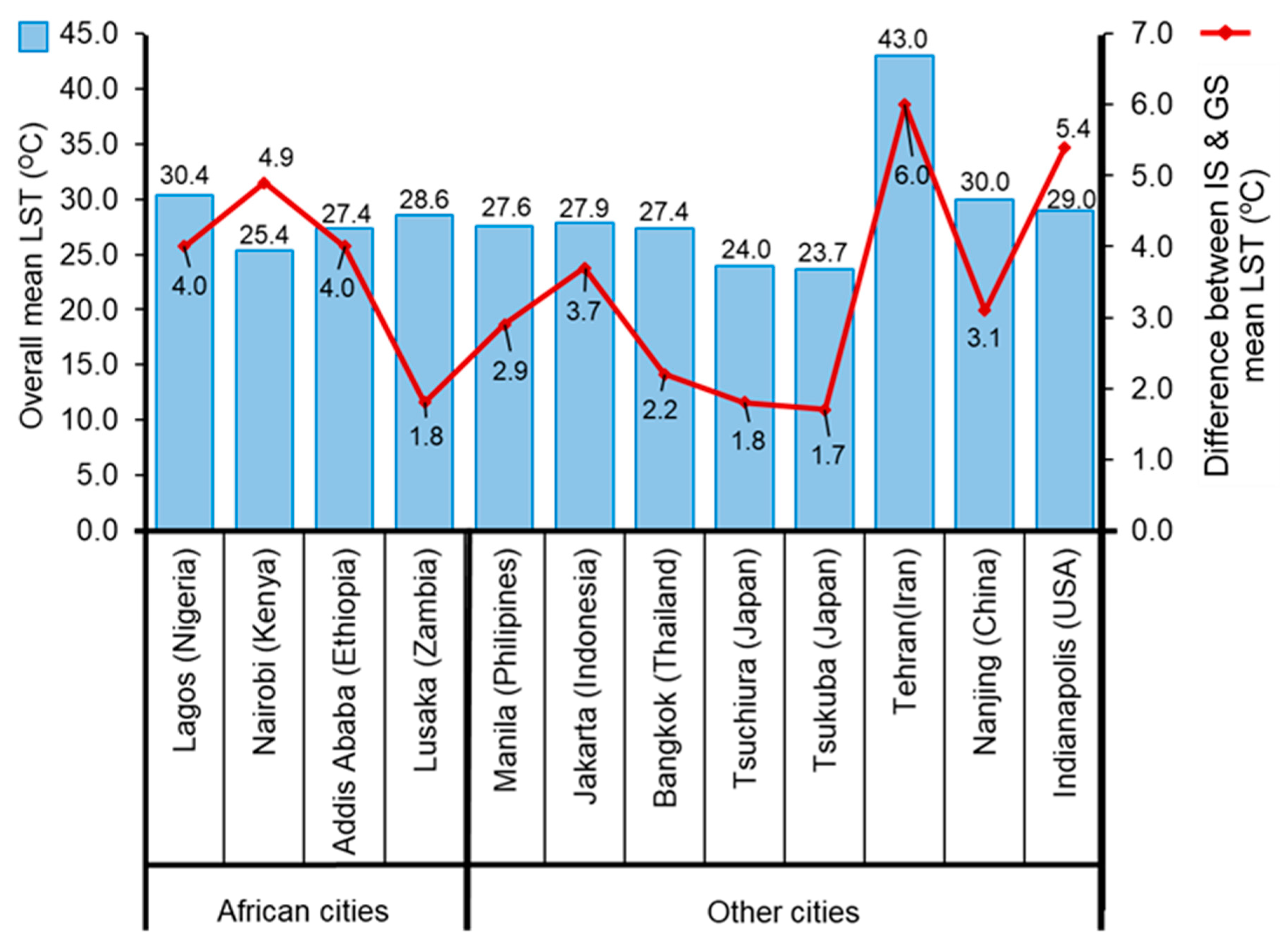
3.1. LST Relationship with Impervious Surfaces and Green Spaces
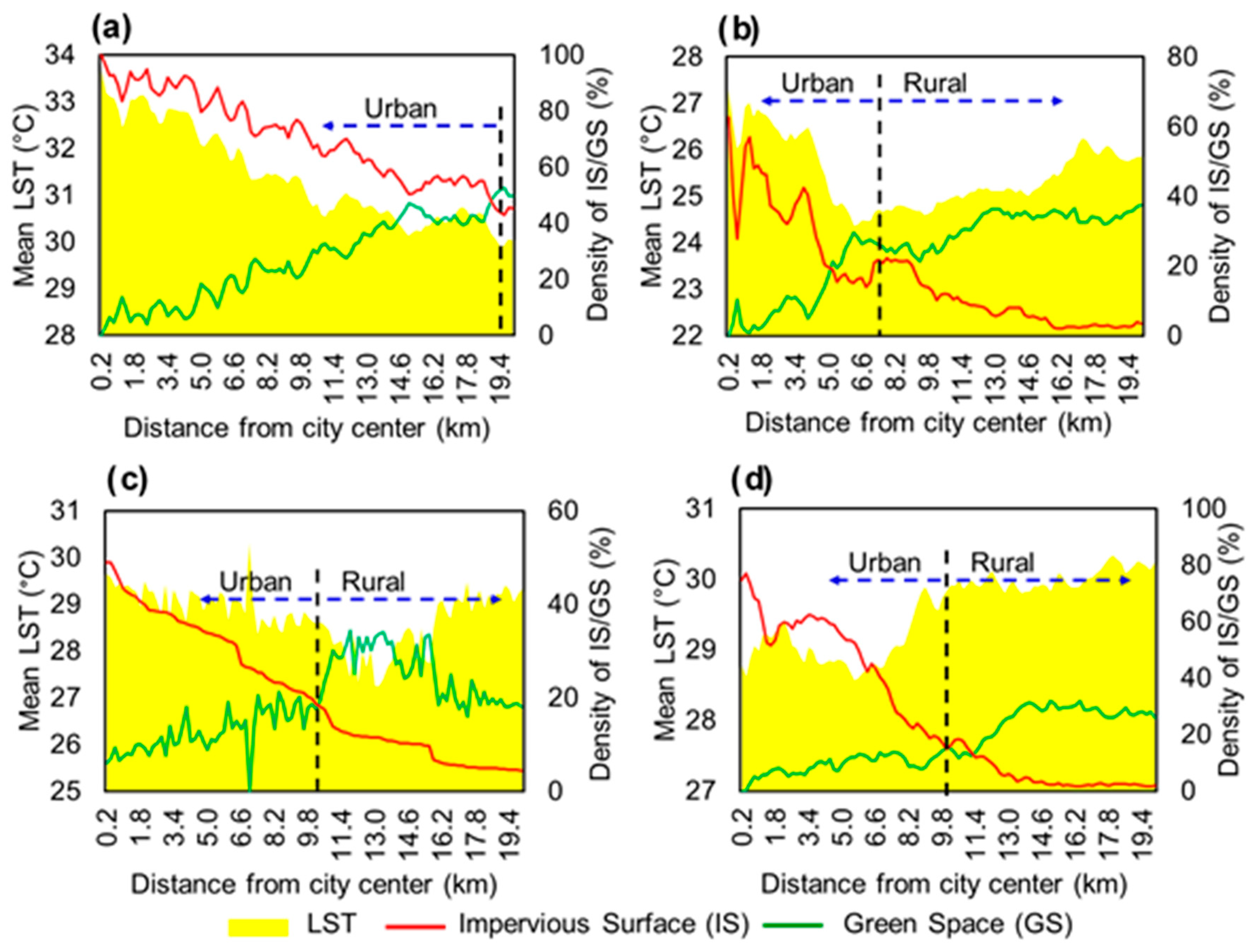
3.2. LST Relationship with Impervious Surfaces and Green Spaces along the Urban–Rural Gradient
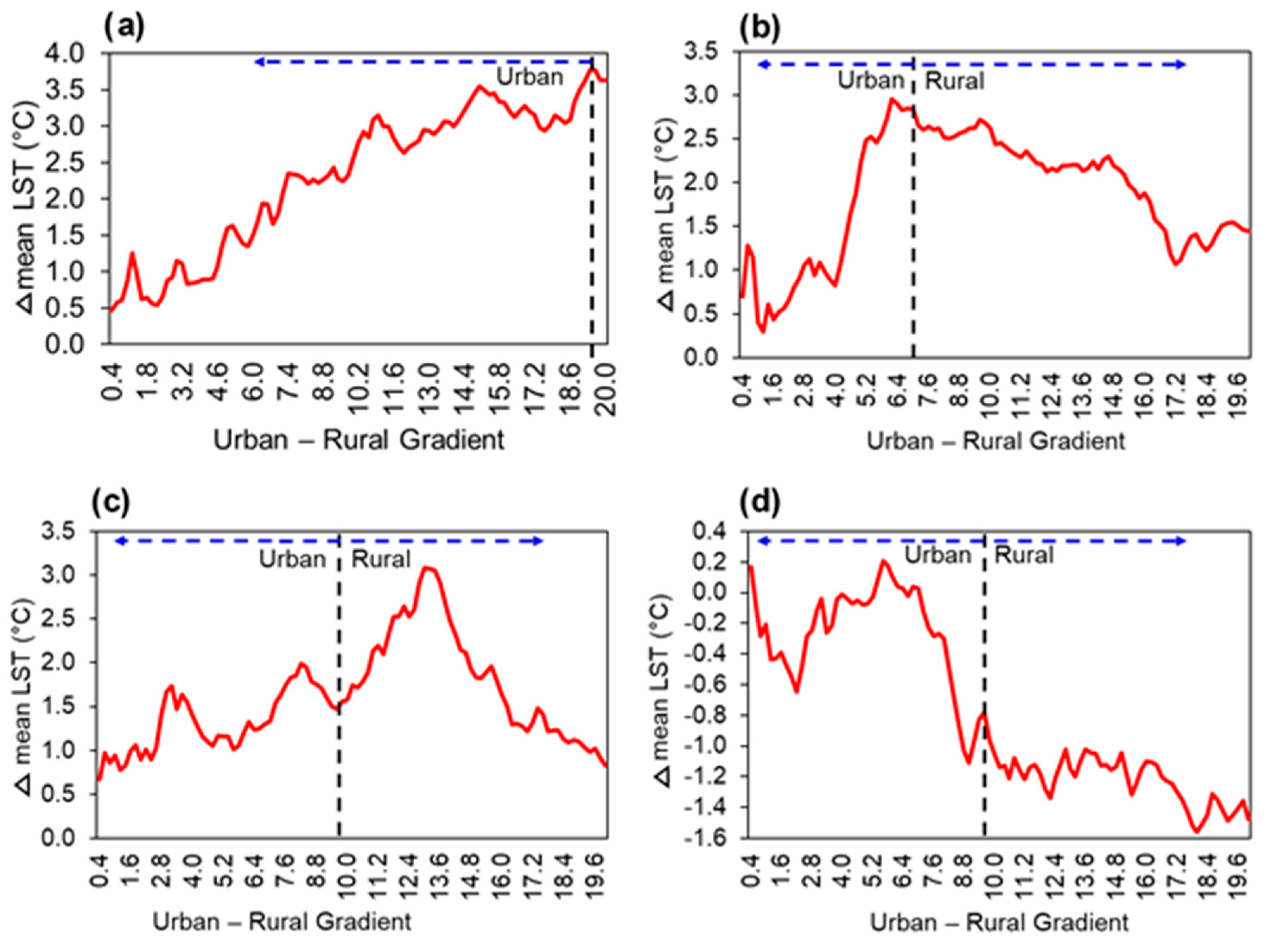
3.3. SUHI Intensity Patterns along the Urban–Rural Gradient
3.4. LST Relationship with Urban Landscape Metrics
4. Discussion
4.1. Influence of Impervious Surfaces and Green Spaces on LST
4.2. Influence of Impervious Surfaces and Green Spaces on LST and SUHI Intensity Patterns along the Urban–Rural Gradient
4.3. Influence of Spatial Landscape Configuration on LST
4.4. Implications for Mitigating SUHIs in African Cities
5. Conclusions
Author Contributions
Funding
Acknowledgments
Conflicts of Interest
References
- Guneralp, B.; Shuaib, L.; Hillary, M.; Parnell, S.; Seto, K.C. Urbanization in Africa: Challenges and opportunities for conservation Urbanization in Africa: Challenges and opportunities for conservation. Environ. Res. Lett. 2018, 13. [Google Scholar] [CrossRef]
- Roxburgh, C.; Dörr, N.; Leke, A.; Tazi-Riffi, A.; Van Wamelen, A.; Lund, S.; Zeino-Mahmalat, T. Lions on the Move: The Progress and Potential of African Economies; McKinsey Global Institute: New York, NY, USA, 2010. [Google Scholar]
- UN-DESA. World Urbanization Prospects: The 2018 Revision, Highlights; United Nations publication; United Nations, Department of Economic and Social Affairs (UN/DESA), Population Division: 2018. Available online: https://www.un.org/development/desa/publications/2018-revision-of-world-urbanization-prospects.html/ (accessed on 23 June 2019).
- Parnell, S.; Pieterse, E. Africa’s Urban Revolution; Parnell, S., Pieterse, E., Eds.; Zed Books Ltd.: London, UK; New York, NY, USA, 2014. [Google Scholar]
- Simwanda, M.; Murayama, Y. Spatiotemporal patterns of urban land use change in the rapidly growing city of Lusaka, Zambia: Implications for sustainable urban development. Sustain. Cities Soc. 2018, 39, 262–274. [Google Scholar] [CrossRef]
- Li, J.; Song, C.; Cao, L.; Zhu, F.; Meng, X.; Wu, J. Impacts of landscape structure on surface urban heat islands: A case study of Shanghai, China. Remote Sens. Environ. 2011, 115, 3249–3263. [Google Scholar] [CrossRef]
- Zhou, W.; Huang, G.; Cadenasso, M.L. Does spatial configuration matter? Understanding the effects of land cover pattern on land surface temperature in urban landscapes. Landsc. Urban Plan. 2011, 102, 54–63. [Google Scholar] [CrossRef]
- Estoque, R.C.; Murayama, Y.; Myint, S.W. Effects of landscape composition and pattern on land surface temperature: An urban heat island study in the megacities of Southeast Asia. Sci. Total Environ. 2017, 577, 349–359. [Google Scholar] [CrossRef] [PubMed]
- Zhang, X.; Estoque, R.C.; Murayama, Y. An urban heat island study in Nanchang City, China based on land surface temperature and social-ecological variables. Sustain. Cities Soc. 2017, 32, 557–568. [Google Scholar] [CrossRef]
- Ranagalage, M.; Estoque, R.; Zhang, X.; Murayama, Y. Spatial changes of urban heat island formation in the Colombo District, Sri Lanka: Implications for sustainability planning. Sustainability 2018, 10, 1367. [Google Scholar] [CrossRef]
- Buyantuyev, A.; Wu, J. Urban heat islands and landscape heterogeneity: Linking spatiotemporal variations in surface temperatures to land-cover and socioeconomic patterns. Landsc. Ecol. 2010, 25, 17–33. [Google Scholar] [CrossRef]
- Voogt, J.A. Urban Heat Islands: Hotter Cities. Available online: http://www.actionbioscience.org/environment/voogt.html (accessed on 29 April 2018).
- EPA (US Environmental Protection Agency). Reducing Urban Heat Islands: Compendium of Strategies; US Environmental Protection Agency: Washington, DC, USA, 2008.
- Li, X.; Zhou, W.; Ouyang, Z. Relationship between land surface temperature and spatial pattern of greenspace: What are the effects of spatial resolution? Landsc. Urban Plan. 2013, 114, 1–8. [Google Scholar] [CrossRef]
- Weng, Q. Thermal infrared remote sensing for urban climate and environmental studies: Methods, applications, and trends. ISPRS J. Photogramm. Remote Sens. 2009, 64, 335–344. [Google Scholar] [CrossRef]
- Liu, L.; Zhang, Y. Urban heat island analysis using the Landsat TM Data and ASTER Data: A Case Study in Hong Kong. Remote Sens. 2011, 3, 1535–1552. [Google Scholar] [CrossRef]
- Weng, Q.; Lu, D.; Schubring, J. Estimation of land surface temperature-vegetation abundance relationship for urban heat island studies. Remote Sens. Environ. 2004, 89, 467–483. [Google Scholar] [CrossRef]
- Sun, Q.; Wu, Z.; Tan, J. The relationship between land surface temperature and land use/land cover in Guangzhou, China. Environ. Earth Sci. 2012, 65, 1687–1694. [Google Scholar] [CrossRef]
- Ranagalage, M.; Estoque, R.C.; Handayani, H.H.; Zhang, X.; Morimoto, T.; Tadono, T.; Murayama, Y. Relation between urban volume and land surface temperature: A comparative study of planned and traditional cities in Japan. Sustainability 2018, 10, 2366. [Google Scholar] [CrossRef]
- Liu, H.; Zhan, Q.; Gao, S. Seasonal Variation of the Spatially Non-Stationary Association Between Land Surface Temperature and Urban Landscape. Remote Sens. 2019, 11, 1016. [Google Scholar] [CrossRef]
- Xiao, R.; Ouyang, Z.; Zheng, H.; Li, W.; Schienke, E.W.; Wang, X. Spatial pattern of impervious surfaces and their impacts on land surface temperature in Beijing, China. J. Environ. Sci. (China) 2007, 19, 250–256. [Google Scholar] [CrossRef]
- Ogashawara, I.; Brum, S. A Quantitative approach for analyzing the relationship between urban heat islands and land cover. Remote Sens. 2012, 4, 3596–3618. [Google Scholar] [CrossRef]
- Estoque, R.C.; Murayama, Y. Monitoring surface urban heat island formation in a tropical mountain city using Landsat data (1987–2015). ISPRS J. Photogramm. Remote Sens. 2017, 133, 18–29. [Google Scholar] [CrossRef]
- Maimaitiyiming, M.; Ghulam, A.; Tiyip, T.; Pla, F.; Latorre-Carmona, P.; Halik, Ü.; Sawut, M.; Caetano, M. Effects of green space spatial pattern on land surface temperature: Implications for sustainable urban planning and climate change adaptation. ISPRS J. Photogramm. Remote Sens. 2014, 89, 59–66. [Google Scholar] [CrossRef]
- Ranagalage, M.; Dissanayake, D.; Murayama, Y.; Zhang, X.; Estoque, R.C.; Perera, E.; Morimoto, T. Quantifying surface urban heat island formation in the world heritage tropical mountain city of Sri Lanka. Int. J. Geo-Inf. 2018, 7, 341. [Google Scholar] [CrossRef]
- Kong, F.; Yin, H.; James, P.; Hutyra, L.R.; He, H.S. Effects of spatial pattern of greenspace on urban cooling in a large metropolitan area of eastern China. Landsc. Urban Plan. 2014, 128, 35–47. [Google Scholar] [CrossRef]
- Bowler, D.E.; Buyung-ali, L.; Knight, T.M.; Pullin, A.S. Urban greening to cool towns and cities: A systematic review of the empirical evidence. Landsc. Urban Plan. 2010, 97, 147–155. [Google Scholar] [CrossRef]
- Ranagalage, M.; Estoque, R.C.; Murayama, Y. An urban heat island study of the Colombo Metropolitan Area, Sri Lanka, based on Landsat Data (1997–2017). ISPRS Int. J. Geo-Inf. 2017, 6, 189. [Google Scholar] [CrossRef]
- Rousta, I.; Sarif, O.; Gupta, R.D.; Olafsson, H.; Ranagalage, M.; Murayama, Y.; Zhang, H.; Mushore, T.D. Spatiotemporal analysis of land use / land cover and its effects on surface urban heat island using Landsat Data: A case study of Metropolitan City Tehran. Sustainability 2018, 10, 4433. [Google Scholar] [CrossRef]
- Memon, R.A.; Leung, D.Y.C.; Liu, C.H. An investigation of urban heat island intensity (UHII) as an indicator of urban heating. Atmos. Res. 2009, 94, 491–500. [Google Scholar] [CrossRef]
- Sheng, L.; Tang, X.; You, H.; Gu, Q.; Hu, H. Comparison of the urban heat island intensity quantified by using air temperature and Landsat land surface temperature in Hangzhou. Ecol. Indic. 2017, 72, 738–746. [Google Scholar] [CrossRef]
- Ngie, A.; Abutaleb, K.; Ahmed, F.; Taiwo, O.J.; Darwish, A.A.; Ahmed, M. An estimation of land surface temperatures from Landsat ETM + images for Durban, South Africa. Rwanda J. 2008, 1. [Google Scholar] [CrossRef]
- Dissanayake, D.; Morimoto, T.; Murayama, Y.; Ranagalage, M.; Handayani, H.H. Impact of urban surface characteristics and socio-economic variables on the spatial variation of land surface temperature in Lagos City, Nigeria. Sustainability 2018, 11, 25. [Google Scholar] [CrossRef]
- Dissanayake, D.; Morimoto, T.; Murayama, Y.; Ranagalage, M. Impact of landscape structure on the variation of land surface temperature in sub-saharan region: A case study of Addis Ababa using Landsat Data. Sustainability 2019, 11, 2257. [Google Scholar] [CrossRef]
- UN-DESA The World’s Cities in 2016—Data Booklet (ST/ESA/ SER.A/392); United Nations publication; United Nations, Department of Economic and Social Affairs (UN/DESA), Population Division: 2016. Available online: https://bit.ly/2JBQ2S6 (accessed on 23 June 2019).
- ClimaTemps World Climate and Temperature; Lagos, Addis Ababa, Nairobi and Lusaka. Available online: http://www.climatemps.com/ (accessed on 23 January 2019).
- Simwanda, M.; Murayama, Y. Integrating geospatial techniques for urban land use classification in the developing sub-saharan African City of Lusaka, Zambia. ISPRS Int. J. Geo-Inf. 2017, 6, 102. [Google Scholar] [CrossRef]
- Gong, H.; Simwanda, M.; Murayama, Y. An internet-based GIS platform providing data for visualization and spatial analysis of urbanization in major Asian and African Cities. ISPRS Int. J. Geo-Inf. 2017, 6, 257. [Google Scholar] [CrossRef]
- Tran, H.; Uchihama, D.; Ochi, S.; Yasuoka, Y. Assessment with satellite data of the urban heat island effects in Asian mega cities. Int. J. Appl. Earth Obs. Geoinf. 2006, 8, 34–48. [Google Scholar] [CrossRef]
- Chander, G.; Markham, B.L.; Helder, D.L. Summary of current radiometric calibration coefficients for Landsat MSS, TM, ETM+, and EO-1 ALI sensors. Remote Sens. Environ. 2009, 113, 893–903. [Google Scholar] [CrossRef]
- USGS (United States Geological Survey). Product Guide: Provisional Landsat 8 Surface Reflectance Product; Department of the Interior, U.S. Geological Survey: Reston, VA, USA, 2016.
- Sobrino, J.A.; Jiménez-Muñoz, J.C.; Paolini, L. Land surface temperature retrieval from LANDSAT TM 5. Remote Sens. Environ. 2004, 90, 434–440. [Google Scholar] [CrossRef]
- Artis, D.A.; Carnahan, W.H. Survey of emissivity variability in thennography of urban areas. Remote Sens. Environ. 1982, 12, 313–329. [Google Scholar] [CrossRef]
- Xu, H. Modification of normalised difference water index (NDWI) to enhance open water features in remotely sensed imagery. Int. J. Remote Sens. 2006, 27, 3025–3033. [Google Scholar] [CrossRef]
- Estoque, R.C.; Murayama, Y. Classification and change detection of built-up lands from Landsat-7 ETM + and Landsat-8 OLI / TIRS imageries: A comparative assessment of various spectral indices. Ecol. Indic. 2015, 56, 205–217. [Google Scholar] [CrossRef]
- Zha, Y.; Gao, J.; Ni, S. Use of normalized di ff erence built-up index in automatically mapping urban areas from TM imagery. Int. J. Remote Sens. 2003, 24, 583–594. [Google Scholar] [CrossRef]
- Zhang, L.; Wu, J.; Zhen, Y.; Shu, J. A GIS-based gradient analysis of urban landscape pattern of Shanghai metropolitan area, China. Landsc. Urban Plan. 2004, 69, 1–16. [Google Scholar] [CrossRef]
- Zhou, X.; Wang, Y. Spatial—Temporal dynamics of urban green space in response to rapid urbanization and greening policies. Landsc. Urban Plan. 2011, 100, 268–277. [Google Scholar] [CrossRef]
- Kroll, F.; Müller, F.; Haase, D.; Fohrer, N. Rural—Urban gradient analysis of ecosystem services supply and demand dynamics. Land Use Policy 2012, 29, 521–535. [Google Scholar] [CrossRef]
- Oke, T.R. City size and the urban heat island. Atmos. Environ. 1973, 7, 769–779. [Google Scholar] [CrossRef]
- Levermore, G.; Parkinson, J.; Lee, K.; Laycock, P.; Lindley, S. The increasing trend of the urban heat island intensity. Urban Clim. 2017, 24, 360–368. [Google Scholar] [CrossRef]
- Takebayashi, H.; Senoo, M. Analysis of the relationship between urban size and heat island intensity using WRF model. Urban Clim. 2016, 24, 287–298. [Google Scholar] [CrossRef]
- Martin-vide, J.; Sarricolea, P.; Moreno-garcía, M.C. On the definition of urban heat island intensity: The “rural” reference. Front. Earth Sci. 2015, 3, 24. [Google Scholar] [CrossRef]
- Montgomery, M.; Stren, R.; Cohen, B.; Reed, H. Cities Transformed: Demographic Change and Its Implications in the Developing World; National Academies Press: Washington, DC, USA, 2003. [Google Scholar]
- Potere, D.; Schneider, A.; Angel, S.; Civco, D.L. Mapping urban areas on a global scale: Which of the eight maps now available is more accurate? Int. J. Remote Sens. 2009, 30, 6531–6558. [Google Scholar] [CrossRef]
- Zlatanova, S.; Ledoux, H.; Fendel, E.M.; Rumor, M. Urban and regional data management: UDMS Annual 2011. In Urban Data Management Society Symposium, Delft, The Netherlands, 28-30 Septemebr 2011; CRC Press/Balkema: Leiden, The Netherlands, 2012. [Google Scholar]
- Taubenböck, H.; Esch, T.; Felbier, A.; Wiesner, M.; Roth, A.; Dech, S. Monitoring urbanization in mega cities from space. Remote Sens. Environ. 2012, 117, 162–176. [Google Scholar] [CrossRef]
- Herold, M.; Scepan, J.; Clarke, K.C. The use of remote sensing and landscape metrics to describe structures and changes in urban land uses. Environ. Plan. A 2002, 34, 1443–1458. [Google Scholar] [CrossRef]
- Van de Voorde, T.; Jacquet, W.; Canters, F. Mapping form and function in urban areas: An approach based on urban metrics and continuous impervious surface data. Landsc. Urban Plan. 2011, 102, 143–155. [Google Scholar] [CrossRef]
- Mcgarigal, K. FRAGSTATS v4.2: Spatial Pattern Analysis Program for Categorical and Continuous Maps. Computer Produced by the Authors. 2015, pp. 1–182. Available online: https://www.umass.edu/landeco/research/fragstats/downloads/fragstats_downloads.html/ (accessed on 23 January 2019).
- Forman, R.T.T. Land Mosaics, the Ecology of Landscapes and Regions; Cambridge University Press: Cambridge, UK, 1995. [Google Scholar]
- Bokaie, M.; Zarkesh, M.K.; Arasteh, P.D.; Hosseini, A. Assessment of urban heat island based on the relationship between land surface temperature and Land Use/Land Cover in Tehran. Sustain. Cities Soc. 2016, 23, 94–104. [Google Scholar] [CrossRef]
- Haylemariyam, M.B. Detection of land surface temperature in relation to land use land cover change: Dire Dawa City, Ethiopia. J. Remote Sens. GIS 2018, 7, 245. [Google Scholar] [CrossRef]
- Chang, C.; Li, M.; Chang, S. A preliminary study on the local cool-island intensity of Taipei city parks. Landsc. Urban Plan. 2007, 80, 386–395. [Google Scholar] [CrossRef]
- Zhang, X.; Zhong, T.; Feng, X.; Wang, K. Estimation of the relationship between vegetation patches and urban land surface temperature with remote sensing. Int. J. Remote 2009, 8, 2105–2118. [Google Scholar] [CrossRef]
- Elmqvist, T.; Setälä, H.; Handel, S.N.; van der Ploeg, S.; Aronson, J.; Blignaut, J.N.; Gómez-Baggethun, E.; Nowak, D.J.; Kronenberg, J.; de Groot, R. Benefits of restoring ecosystem services in urban areas. Curr. Opin. Environ. Sustain. 2015, 14, 101–108. [Google Scholar] [CrossRef]
- Galagoda, R.U.; Jayasinghe, G.Y.; Halwatura, R.U.; Rupasinghe, H.T. The impact of urban green infrastructure as a sustainable approach towards tropical micro-climatic changes and human thermal comfort. Urban For. Urban Green. 2018, 34, 1–9. [Google Scholar] [CrossRef]
- Lin, J.; Huang, B.; Chen, M.; Huang, Z. Modeling urban vertical growth using cellular automata d Guangzhou as a case study. Appl. Geogr. 2014, 53, 172–186. [Google Scholar] [CrossRef]


| City | Sensor | Scene ID | Acquisition Date | Time (GMT) | Season |
|---|---|---|---|---|---|
| Addis Ababa | Landsat-8 OLI/TIRS | LC81680542017026LGN00 | 26-January 2017 | 7:40:29 | Dry |
| Lagos | Landsat-8 OLI/TIRS | LC81910552015342LGN00 | 8-December 2015 | 10:03:03 | Dry |
| Nairobi | Landsat-8 OLI/TIRS | LC81680612016216LGN00 | 3-August 2016 | 7:43:12 | Dry |
| Lusaka | Landsat-8 OLI/TIRS | LC81720712016212LGN00 | 20-July 2016 | 8:11:54 | Dry |
| Metric (Abbreviation) | Description | Measure | Equation |
|---|---|---|---|
| Mean Patch Area (AREA_MN) | Average patch area—total impervious surface or green space area divided by number of their respective patches - (unit: km2) | Composition | |
| Patch Density (PD) | The number of patches per unit area of impervious surface or green space (unit: number per km2). | Composition and spatial arrangement | |
| Mean Shape Index (SHAPE_MN) | Mean value of shape index—it is the simplest and most straightforward measure of shape complexity. MSI is greater than one; MSI = 1 would result if all impervious surface or green space patches were circular or square grids (unit: none). | Shape and complexity | |
| Mean Fractal Dimension Index (FRAC_MN) | FRAC_MN also measures shape complexity. FRAC_MN approaches one for shapes with simple perimeters and approaches two when shapes are more complex (unit: none). | Shape and Complexity | |
| Aggregation Index (AI) | The tendency of impervious surface or green space patches to be spatially aggregated (unit: none). | Spatial arrangement |
| Study Area | PD | AREA_MN | SHAPE_MN | FRAC_MN | AI | |||||
|---|---|---|---|---|---|---|---|---|---|---|
| r | Sig. | r | Sig. | r | Sig. | r | Sig. | r | Sig. | |
| Impervious Surface Mean LST vs. Spatial Metrics | ||||||||||
| Lagos | 0.027 | 0.807 | 0.519 | 0.000 | 0.147 | 0.180 | 0.182 | 0.096 | 0.432 | 0.000 |
| Nairobi | 0.339 | 0.002 | 0.383 | 0.001 | 0.277 | 0.014 | 0.148 | 0.197 | 0.402 | 0.000 |
| Addis Ababa | 0.540 | 0.000 | 0.244 | 0.029 | 0.265 | 0.018 | 0.197 | 0.080 | 0.289 | 0.009 |
| Lusaka | 0.199 | 0.076 | 0.025 | 0.827 | 0.035 | 0.758 | 0.097 | 0.391 | 0.122 | 0.280 |
| Green Space Mean LST vs. Spatial Metrics | ||||||||||
| Lagos | −0.362 | 0.001 | −0.316 | 0.004 | −0.421 | 0.000 | −0.378 | 0.000 | −0.190 | 0.085 |
| Nairobi | −0.151 | 0.179 | −0.281 | 0.011 | −0.418 | 0.000 | −0.123 | 0.272 | −0.700 | 0.000 |
| Addis Ababa | −0.135 | 0.229 | −0.221 | 0.047 | −0.489 | 0.000 | −0.485 | 0.000 | −0.321 | 0.004 |
| Lusaka | −0.189 | 0.091 | −0.313 | 0.004 | −0.336 | 0.002 | −0.298 | 0.007 | −0.244 | 0.028 |
© 2019 by the authors. Licensee MDPI, Basel, Switzerland. This article is an open access article distributed under the terms and conditions of the Creative Commons Attribution (CC BY) license (http://creativecommons.org/licenses/by/4.0/).
Share and Cite
Simwanda, M.; Ranagalage, M.; Estoque, R.C.; Murayama, Y. Spatial Analysis of Surface Urban Heat Islands in Four Rapidly Growing African Cities. Remote Sens. 2019, 11, 1645. https://doi.org/10.3390/rs11141645
Simwanda M, Ranagalage M, Estoque RC, Murayama Y. Spatial Analysis of Surface Urban Heat Islands in Four Rapidly Growing African Cities. Remote Sensing. 2019; 11(14):1645. https://doi.org/10.3390/rs11141645
Chicago/Turabian StyleSimwanda, Matamyo, Manjula Ranagalage, Ronald C. Estoque, and Yuji Murayama. 2019. "Spatial Analysis of Surface Urban Heat Islands in Four Rapidly Growing African Cities" Remote Sensing 11, no. 14: 1645. https://doi.org/10.3390/rs11141645
APA StyleSimwanda, M., Ranagalage, M., Estoque, R. C., & Murayama, Y. (2019). Spatial Analysis of Surface Urban Heat Islands in Four Rapidly Growing African Cities. Remote Sensing, 11(14), 1645. https://doi.org/10.3390/rs11141645