Integrating Latent Heat Flux Products from MODIS and Landsat Data Using Multi-Resolution Kalman Filter Method in the Midstream of Heihe River Basin of Northwest China
Abstract
1. Introduction
2. Study Area and Data
2.1. Study Area and Ground Observations
2.2. Remotely Sensed Data
2.2.1. MODIS LE Product
2.2.2. Landsat-Based LE Product
3. Methodology
3.1. The MKF Method
3.2. Assessment Metrics
4. Results and Discussion
4.1. Integration of Satellite-Derived LE Products
4.2. Comparison before and after MKF
4.2.1. Spatial Assessment of the MKF Integration Performance
4.2.2. Evaluation of the MKF Performance Using Ground Observations
4.3. Discussion
4.3.1. Uncertainty Analysis
4.3.2. Superiority and Recommendation for the MKF integration
5. Conclusions
Author Contributions
Funding
Acknowledgments
Conflicts of Interest
Appendix A. Details of the MKF Method
Appendix A.1. Initialization
Appendix A.2. Fine-to Coarse Sweep
Appendix A.3. Coarse-to-Fine Sweep
Appendix B. Details of the MS-PT Algorithm Logic
References
- Liang, S.; Wang, K.; Zhang, X.; Wild, M. Review on Estimation of Land Surface Radiation and Energy Budgets From Ground Measurement, Remote Sensing and Model Simulations. IEEE J. Sel. Top. Appl. Earth Obs. Remote Sens. 2010, 3, 225–240. [Google Scholar] [CrossRef]
- Yao, Y.; Liang, S.; Yu, J.; Chen, J.; Liu, S.; Lin, Y.; Fisher, J.B.; McVicar, T.R.; Cheng, J.; Jia, K.; et al. A simple temperature domain two-source model for estimating agricultural field surface energy fluxes from Landsat images. J. Geophys. Res. Atmos. 2017, 122, 5211–5236. [Google Scholar] [CrossRef]
- Gao, G.; Chen, D.; Xu, C.Y.; Simelton, E. Trend of estimated actual evapotranspiration over China during 1960–2002. J. Geophys. Res. Atmos. 2007, 112, 8. [Google Scholar] [CrossRef]
- Wang, K.; Dickinson, R.E. A review of global terrestrial evapotranspiration: Observation, modeling, climatology, and climatic variability. Rev. Geophys. 2012, 50, RG2005. [Google Scholar] [CrossRef]
- Farahani, H.J.; Howell, T.A.; Shuttleworth, W.J.; Bausch, W.C. Evapotranspiration: Progress in Measurement and Modeling in Agriculture. Trans. ASABE 2007, 50, 1627–1638. [Google Scholar] [CrossRef]
- Cheng, J.; Kustas, W.P. Using Very High Resolution Thermal Infrared Imagery for More Accurate Determination of the Impact of Land Cover Differences on Evapotranspiration in an Irrigated Agricultural Area. Remote Sens. 2019, 11, 18. [Google Scholar] [CrossRef]
- Bastiaanssen, W.G.M.; Noordman, E.J.M.; Pelgrum, H.; Davids, G.; Allen, R.G. SEBAL Model with Remotely Sensed Data to Improve Water-Resources Management under Actual Field Conditions. J. Irrig. Drain. Eng. 2005, 131, 85–93. [Google Scholar] [CrossRef]
- Kool, D.; Agam, N.; Lazarovitch, N.; Heitman, J.L.; Sauer, T.J.; Ben-Gal, A. A review of approaches for evapotranspiration partitioning. Agric. For. Meteorol. 2014, 184, 56–70. [Google Scholar] [CrossRef]
- Yuan, W.P.; Liu, S.G.; Yu, G.R.; Bonnefond, J.M.; Chen, J.Q.; Davis, K.; Desai, A.R.; Goldstein, A.H.; Gianelle, D.; Rossi, F. Global estimates of evapotranspiration and gross primary production based on MODIS and global meteorology data. Remote Sens. Environ. 2010, 114, 1416–1431. [Google Scholar] [CrossRef]
- Mallick, K.; Bhattacharya, B.K.; Rao, V.U.M.; Reddy, D.R.; Banerjee, S.; Venkatesh, H.; Pandey, V.; Kar, G.; Mukherjee, J.; Vyas, S.P. Latent heat flux estimation in clear sky days over Indian agroecosystems using noontime satellite remote sensing data. Agric. For. Meteorol. 2015, 149, 1646–1665. [Google Scholar] [CrossRef]
- Liu, S.; Xu, Z.; Song, L.; Zhao, Q.; Yong, G.; Xu, T.; Ma, Y.; Zhu, Z.; Jia, Z.; Zhang, F. Upscaling evapotranspiration measurements from multi-site to the satellite pixel scale over heterogeneous land surfaces. Agric. For. Meteorol. 2016, 230–231, 97–113. [Google Scholar] [CrossRef]
- Jia, Z.; Liu, S.; Xu, Z.; Chen, Y.; Zhu, M. Validation of remotely sensed evapotranspiration over the Hai River Basin, China. J. Geophys. Res. Atmos. 2012, 117, 13113. [Google Scholar] [CrossRef]
- Yao, Y.; Liang, S.; Li, X.; Chen, J.; Liu, S.; Jia, K.; Zhang, X.; Xiao, Z.; Fisher, J.B.; Mu, Q.; et al. Improving global terrestrial evapotranspiration estimation using support vector machine by integrating three process-based algorithms. Agric. For. Meteorol. 2017, 242, 55–74. [Google Scholar] [CrossRef]
- Di, S.C.; Li, Z.L.; Tang, R.; Wu, H.; Tang, B.H.; Lu, J. Integrating two layers of soil moisture parameters into the MOD16 algorithm to improve evapotranspiration estimations. Int. J. Remote Sens. 2015, 36, 4953–4971. [Google Scholar] [CrossRef]
- Yang, Y.; Long, D.; Shang, S. Remote estimation of terrestrial evapotranspiration without using meteorological data. Geophys. Res. Lett. 2013, 40, 3026–3030. [Google Scholar] [CrossRef]
- Xiong, Y.J.; Zhao, S.H.; Tian, F.; Qiu, G.Y. An evapotranspiration product for arid regions based on the three-temperature model and thermal remote sensing. J. Hydrol. 2015, 530, 392–404. [Google Scholar] [CrossRef]
- Tongren, X.; Zhixia, G.; Shaomin, L.; Xinlei, H.; Yangfanyu, M.; Ziwei, X.; Youlong, X.; Jingfeng, X.; Yuan, Z.; Yanfei, M. Evaluating Different Machine Learning Methods for Upscaling Evapotranspiration from Flux Towers to the Regional Scale. J. Geophys. Res. Atmos. 2018, 123, 8674–8690. [Google Scholar] [CrossRef]
- Ma, Y.; Shaomin, L.; Song, L.; Xu, Z.; Zhu, Z. Estimation of daily evapotranspiration and irrigation water efficiency at a Landsat-like scale for an arid irrigation area using multi-source remote sensing data. Remote Sens. Environ. 2018, 216, 715–734. [Google Scholar] [CrossRef]
- Cheng, G.; Li, X.; Zhao, W.; Xu, Z.; Feng, Q.; Xiao, S.; Xiao, H. Integrated study of the water–ecosystem–economy in the Heihe River Basin. Natl. Sci. Rev. 2014, 1, 413–428. [Google Scholar] [CrossRef]
- Li, X.; Cheng, G.; Ge, Y.; Li, H.; Han, F.; Hu, X.; Tian, W.; Tian, Y.; Pan, X.; Nian, Y. Hydrological Cycle in the Heihe River Basin and Its Implication for Water Resource Management in Endorheic Basins. J. Geophys. Res. Atmos. 2018, 123, 890–914. [Google Scholar] [CrossRef]
- Yao, Y.; Liang, S.; Li, X.; Hong, Y.; Fisher, J.B.; Zhang, N.; Chen, J.; Cheng, J.; Zhao, S.; Zhang, X. Bayesian multimodel estimation of global terrestrial latent heat flux from eddy covariance, meteorological, and satellite observations. J. Geophys. Res. Atmos. 2014, 119, 4521–4545. [Google Scholar] [CrossRef]
- Feng, F.; Li, X.; Yao, Y.; Liang, S.; Chen, J.; Zhao, X.; Jia, K.; Pintér, K.; Mccaughey, J.H. An Empirical Orthogonal Function-Based Algorithm for Estimating Terrestrial Latent Heat Flux from Eddy Covariance, Meteorological and Satellite Observations. PLoS ONE 2016, 11, e0160150. [Google Scholar] [CrossRef]
- Fisher, J.B.; Tu, K.P.; Baldocchi, D.D. Global estimates of the land–atmosphere water flux based on monthly AVHRR and ISLSCP-II data, validated at 16 FLUXNET sites. Remote Sens. Environ. 2008, 112, 901–919. [Google Scholar] [CrossRef]
- Chou, K.C.; Willsky, A.S.; Nikoukhah, R. Multiscale systems, Kalman filters, and Riccati equations. Autom. Control. IEEE Trans. 1992, 39, 479–492. [Google Scholar] [CrossRef]
- He, T.; Liang, S.; Wang, D.; Shuai, Y.; Yu, Y. Fusion of Satellite Land Surface Albedo Products Across Scales Using a Multiresolution Tree Method in the North Central United States. IEEE Trans. Geosci. Remote Sens. 2014, 52, 3428–3439. [Google Scholar] [CrossRef]
- Wang, D.; Liang, S. Using multiresolution tree to integrate MODIS and MISR-L3 LAI products. IEEE Int. Geosci. Remote Sens. Symp. 2010, 38, 1027–1030. [Google Scholar] [CrossRef]
- Cheng, G.D.; Xiao, H.L.; Zhong-Min, X.U.; Jin-Xiu, L.I.; Ming-Feng, L.U. Water Issue and Its Countermeasure in the Inland River Basins of Northwest China—A Case Study in Heihe River Basin. J. Glaciol. Geocryol. 2006, 28, 406–413. [Google Scholar] [CrossRef]
- Mcvicar, T.; Roderick, M.L.; Donohue, R.J.; Li, J.; Thomas, G.V.N.; Paul, G.T.; Jürgen, G.; Deepak, J.; Youcef, H.; Natalie, M.; et al. Global review and synthesis of trends in observed terrestrial near-surface wind speeds: Implications for evaporation. J. Hydrol. 2012, 416, 182–205. [Google Scholar] [CrossRef]
- Li, X.; Liu, S.; Xiao, Q.; Ma, M.; Jin, R.; Che, T.; Wang, W.; Hu, X.; Xu, Z.; Wen, J. A multiscale dataset for understanding complex eco-hydrological processes in a heterogeneous oasis system. Sci. Data 2017, 4, 170083. [Google Scholar] [CrossRef]
- Xu, Z.; Liu, S.; Xin, L.; Shi, S.; Wang, J.; Zhu, Z.; Xu, T.; Wang, W.; Ma, M. Intercomparison of surface energy flux measurement systems used during the HiWATER-MUSOEXE. J. Geophys. Res. Atmos. 2013, 118, 13140–13157. [Google Scholar] [CrossRef]
- Li, X.; Cheng, G.; Liu, S.; Xiao, Q.; Ma, M.; Jin, R.; Che, T.; Liu, Q.; Wang, W.; Qi, Y. Heihe watershed allied telemetry experimental research (HiWater) scientific objectives and experimental design (EI). Bull. Am. Meteorol. Soc. 2013, 94, 1145–1160. [Google Scholar] [CrossRef]
- Twine, T.E.; Kustas, W.P.; Norman, J.M.; Cook, D.R.; Houser, P.R.; Meyers, T.P.; Prueger, J.H.; Starks, P.J.; Wesely, M.L. Correcting eddy-covariance flux underestimates over a grassland. Agric. For. Meteorol. 2000, 103, 279–300. [Google Scholar] [CrossRef]
- Liu, S.M.; Xu, Z.W.; Zhu, Z.L.; Jia, Z.Z.; Zhu, M.J. Measurements of evapotranspiration from eddy-covariance systems and large aperture scintillometers in the Hai River Basin, China. J. Hydrol. 2013, 487, 24–38. [Google Scholar] [CrossRef]
- Liu, S.; Li, X.; Xu, Z.; Che, T.; Xiao, Q.; Ma, M.; Liu, Q.; Jin, R.; Guo, J.; Wang, L.; et al. The Heihe Integrated Observatory Network: A Basin-Scale Land Surface Processes Observatory in China. Vadose Zone J. 2018, 17, 180072. [Google Scholar] [CrossRef]
- Mu, Q.; Heinsch, F.A.; Zhao, M.; Running, S.W. Development of a global evapotranspiration algorithm based on MODIS and global meteorology data. Remote Sens. Environ. 2007, 111, 519–536. [Google Scholar] [CrossRef]
- Mu, Q.; Zhao, M.; Running, S.W. Improvements to a MODIS global terrestrial evapotranspiration algorithm. Remote Sens. Environ. 2011, 115, 1781–1800. [Google Scholar] [CrossRef]
- Monteith, J.L. Evaporation and environment. Symp. Soc. Exp. Biol. 1965, 19, 205–234. [Google Scholar]
- Cleugh, H.A.; Leuning, R.; Mu, Q.; Running, S.W. Regional evaporation estimates from flux tower and MODIS satellite data. Remote Sens. Environ. 2007, 106, 285–304. [Google Scholar] [CrossRef]
- Running, S.; Mu, Q.; Zhao, M. MOD16A2 MODIS/Terra Net Evapotranspiration 8-Day L4 Global 500m SIN Grid V006. NASA EOSDIS Land Process. DAAC 2017. [Google Scholar] [CrossRef]
- Masek, J.G.; Vermote, E.F.; Saleous, N.E.; Wolfe, R.; Hall, F.G.; Huemmrich, K.F.; Gao, F.; Kutler, J.; Lim, T.K. A Landsat surface reflectance dataset for North America, 1990–2000. IEEE Geosci. Remote Sens. Lett. 2006, 3, 68–72. [Google Scholar] [CrossRef]
- Yao, Y.; Liang, S.; Cheng, J.; Liu, S.; Fisher, J.B.; Zhang, X.; Jia, K.; Zhao, X.; Qin, Q.; Zhao, B. MODIS-driven estimation of terrestrial latent heat flux in China based on a modified Priestley–Taylor algorithm. Agric. For. Meteorol. 2013, 171–172, 187–202. [Google Scholar] [CrossRef]
- Yang, K.; He, J.; Tang, W.; Qin, J.; Cheng, C.C.K. On downward shortwave and longwave radiations over high altitude regions: Observation and modeling in the Tibetan Plateau. Agric. For. Meteorol. 2010, 150, 38–46. [Google Scholar] [CrossRef]
- Chen, Y.; Yang, K.; Jie, H.; Qin, J.; Shi, J.; Du, J.; He, Q. Improving land surface temperature modeling for dry land of China. J. Geophys. Res. Atmos. 2011, 116, D20104. [Google Scholar] [CrossRef]
- Zhang, L.; Yao, Y.; Wang, Z.; Jia, K.; Chen, X. Satellite-Derived Spatiotemporal Variations in Evapotranspiration over Northeast China during 1982–2010. Remote Sens. 2017, 9, 1140. [Google Scholar] [CrossRef]
- Vyver, H.V.D.; Roulin, E. Scale-recursive estimation for merging precipitation data from radar and microwave cross-track scanners. J. Geophys. Res. Atmos. 2009, 114, D08104. [Google Scholar] [CrossRef]
- Gupta, R.; Venugopal, V.; Foufoula-Georgiou, E. A methodology for merging multisensor precipitation estimates based on expectation-maximization and scale-recursive estimation. J. Geophys. Res. Atmos. 2015, 111, D02102. [Google Scholar] [CrossRef]
- Luettgen, M.R.; Willsky, A.S. Likelihood calculation for a class of multiscale stochastic models, with application to texture discrimination. IEEE Trans. Image Process. 1995, 4, 194–207. [Google Scholar] [CrossRef]
- Chou, C.K. A Stochastic Modeling Approach to Multiscale Signal Processing. Mass. Inst. Technol. 1991. Available online: https://pdfs.semanticscholar.org/6350/caa3c42a2c12b0342706fe53197820d58ade.pdf (accessed on 30 July 2019).
- Tustison, B.; Foufoula-Georgiou, E.; Harris, D. Scale-recursive estimation for multisensor Quantitative Precipitation Forecast verification: A preliminary assessment. J. Geophys. Res. Atmos. 2002, 107. CIP-1-CIP 2–14. [Google Scholar] [CrossRef]
- Gorenburg, I.P.; Mclaughlin, D.; Entekhabi, D. Scale-recursive assimilation of precipitation data. Adv. Water Resour. 2001, 24, 941–953. [Google Scholar] [CrossRef]
- Yue, W.; Zhu, J. On estimation and prediction for multivariate multiresolution tree-structured spatial linear models. Stat. Sin. 2006, 16, 981–1020. [Google Scholar] [CrossRef]
- Shi, L.; Liang, S.; Cheng, J.; Zhang, Q. Integrating ASTER and GLASS broadband emissivity products using a multi-resolution Kalman filter. Int. J. Digit. Earth 2016, 9, 1098–1116. [Google Scholar] [CrossRef]
- Baldocchi, D. Breathing of the terrestrial biosphere: Lessons learned from a global network of carbon dioxide flux measurement systems. Aust. J. Bot. 2008, 56, 1–26. [Google Scholar] [CrossRef]
- Yao, Y.; Liang, S.; Zhao, S.; Zhang, Y.; Qin, Q.; Cheng, J.; Jia, K.; Xie, X.; Zhang, N.; Liu, M. Validation and Application of the Modified Satellite-Based Priestley-Taylor Algorithm for Mapping Terrestrial Evapotranspiration. Remote Sens. 2014, 6, 880–904. [Google Scholar] [CrossRef]
- Yao, Y.; Liang, S.; Li, X.; Chen, J.; Wang, K.; Jia, K.; Cheng, J.; Jiang, B.; Fisher, J.B.; Mu, Q.; et al. A satellite-based hybrid algorithm to determine the Priestley-Taylor parameter for global terrestrial latent heat flux estimation across multiple biomes. Remote Sens. Environ. 2015, 165, 216–233. [Google Scholar] [CrossRef]
- Anderson, M.C.; Norman, J.M.; Kustas, W.P.; Houborg, R.; Starks, P.J.; Agam, N. A thermal-based remote sensing technique for routine mapping of land-surface carbon, water and energy fluxes from field to regional scales. Remote Sens. Environ. 2008, 112, 4227–4241. [Google Scholar] [CrossRef]
- Hu, G.; Li, J. Monitoring of Evapotranspiration in a Semi-Arid Inland River Basin by Combining Microwave and Optical Remote Sensing Observations. Remote Sens. 2015, 7, 3056–3087. [Google Scholar] [CrossRef]
- Liu, Z.; Shao, Q.; Liu, J. The Performances of MODIS-GPP and -ET Products in China and Their Sensitivity to Input Data (FPAR/LAI). Remote Sens. 2014, 7, 135–152. [Google Scholar] [CrossRef]
- Velpuri, N.M.; Senay, G.B.; Singh, R.K.; Bohms, S.; Verdin, J.P. A comprehensive evaluation of two MODIS evapotranspiration products over the conterminous United States: Using point and gridded FLUXNET and water balance ET. Remote Sens. Environ. 2013, 139, 35–49. [Google Scholar] [CrossRef]
- Kim, H.W.; Hwang, K.; Mu, Q.; Lee, S.O.; Choi, M. Validation of MODIS 16 global terrestrial evapotranspiration products in various climates and land cover types in Asia. Ksce J. Civ. Eng. 2012, 16, 229–238. [Google Scholar] [CrossRef]
- Ruhoff, A.L.; Paz, A.R.; Aragao, L.E.O.C.; Mu, Q.; Malhi, Y.; Collischonn, W.; Rocha, H.R.; Running, S.W. Assessment of the MODIS global evapotranspiration algorithm using eddy covariance measurements and hydrological modelling in the Rio Grande basin. Int. Assoc. Sci. Hydrol. Bull. 2013, 58, 1658–1676. [Google Scholar] [CrossRef]
- Wang, J.; Zhuang, J.; Wang, W.; Liu, S.; Xu, Z. Assessment of uncertainties in eddy covariance flux measurement based on intensive flux matrix of HiWATER-MUSOEXE. IEEE Geosci. Remote Sens. Lett. 2015, 12, 259–263. [Google Scholar] [CrossRef]
- Wilson, K.; Goldstein, A.; Falge, E.; Aubinet, M.; Baldocchi, D.; Berbigier, P.; Bernhofer, C.; Ceulemans, R.; Han, D.; Field, C. Energy balance closure at FLUXNET sites. Agric. For. Meteorol. 2002, 113, 223–243. [Google Scholar] [CrossRef]
- Finnigan, J.J.; Clement, R.; Malhi, Y.; Leuning, R.; Cleugh, H.A. A Re-Evaluation of Long-Term Flux Measurement Techniques Part I: Averaging and Coordinate Rotation. Bound. Layer Meteorol. 2003, 107, 1–48. [Google Scholar] [CrossRef]
- Fieguth, P.W.; Karl, W.C.; Willsky, A.S.; Wunsch, C. Multiresolution optimal interpolation and statistical analysis of TOPEX/POSEIDON satellite altimetry. Geosci. Remote Sens. IEEE Trans. 1995, 33, 280–292. [Google Scholar] [CrossRef]
- Kannan, A.; Ostendorf, M.; Karl, W.C.; Castanon, D.A.; Fish, R.K. ML parameter estimation of a multiscale stochastic process using the EM algorithm. IEEE Trans. Signal. Process. 2002, 48, 1836–1840. [Google Scholar] [CrossRef]
- Zhang, K.; Kimball, J.S.; Mu, Q.; Jones, L.A.; Goetz, S.J.; Running, S.W. Satellite based analysis of northern ET trends and associated changes in the regional water balance from 1983 to 2005. J. Hydrol. 2009, 379, 92–110. [Google Scholar] [CrossRef]
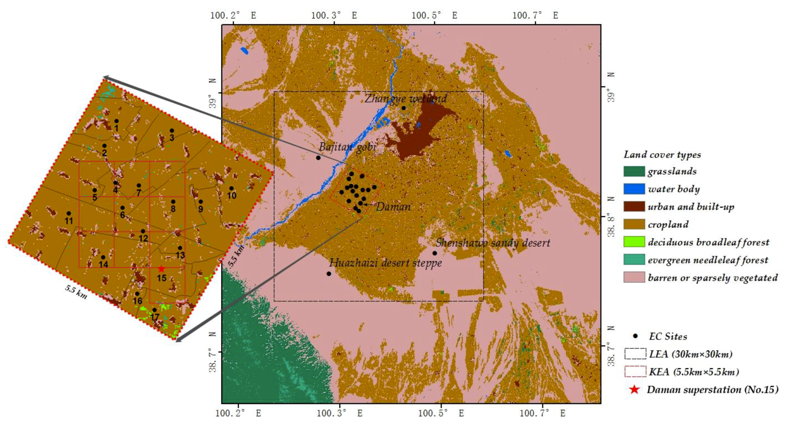
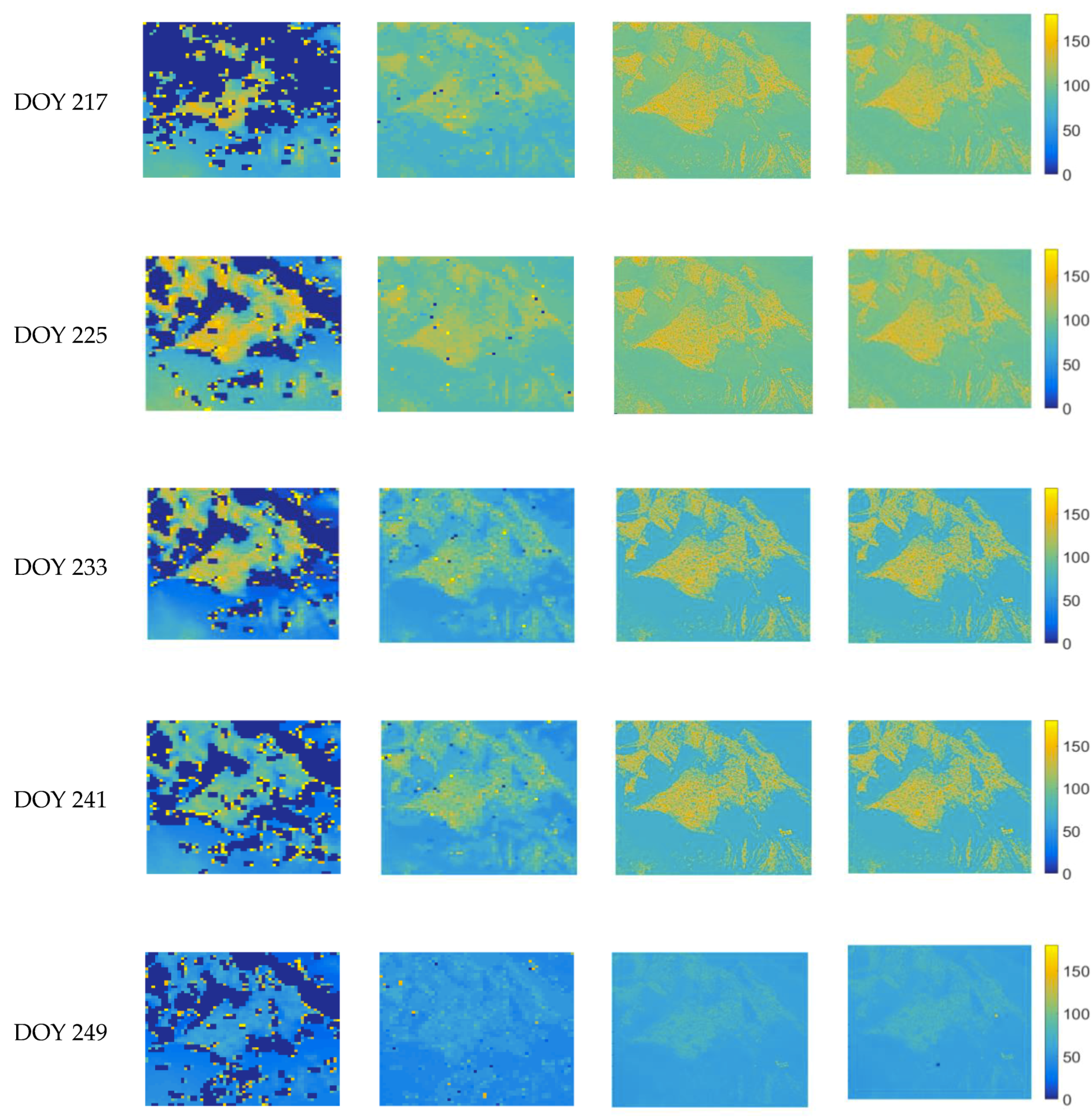
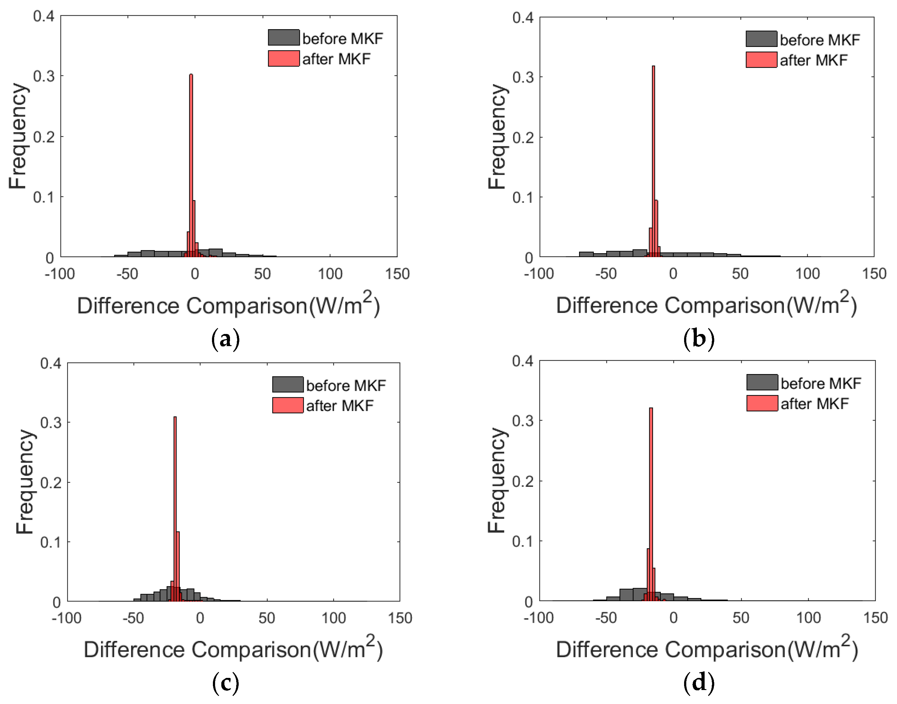
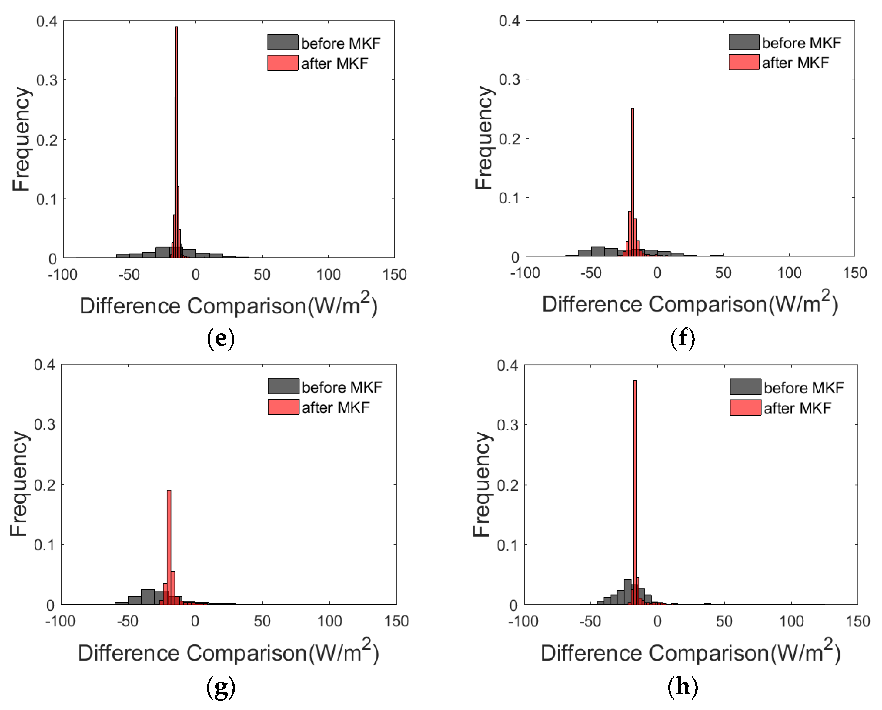
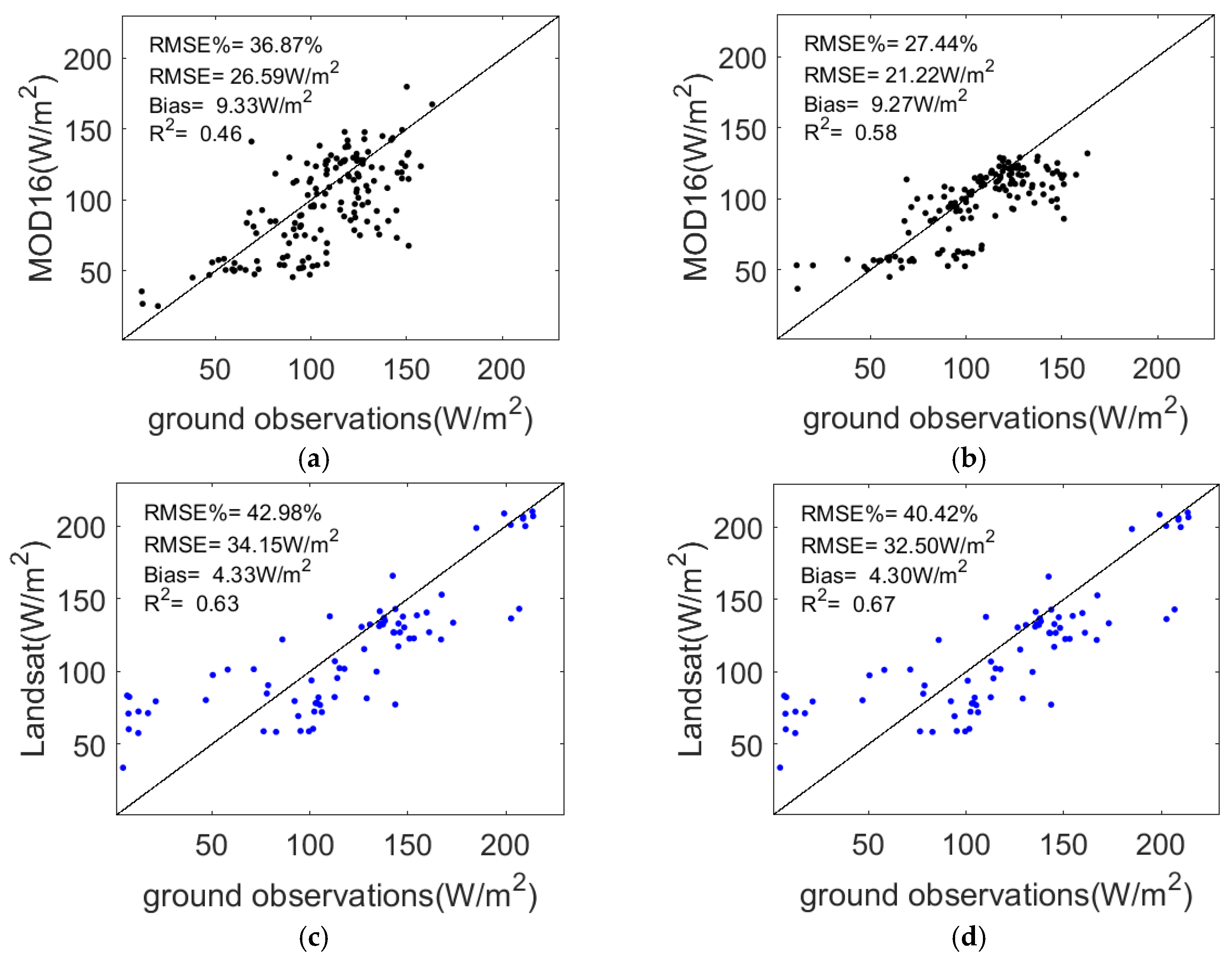

| Observed Sites | Longitude | Latitude | Land Cover | Duration 1 |
|---|---|---|---|---|
| Zhangye wetland | 100.45° | 38.98° | wetland | 6/2012–12/2016 |
| Shenshawo sandy desert | 100.49° | 38.79° | barren land | 6/2012–4/2015 |
| Huazhaizi desert steppe | 100.32° | 38.77° | barren land | 6/2012–12/2016 |
| Bajitan Gobi | 100.30° | 38.92° | barren land | 6/2012–4/2015 |
| 1 | 100.36° | 38.89° | cropland | 6/10/2012–9/17/2012 |
| 2 | 100.35° | 38.89° | cropland | 5/3/2012–9/21/2012 |
| 3 | 100.38° | 38.89° | cropland | 6/3/2012–9/18/2012 |
| 4 | 100.36° | 38.88° | cropland | 5/10/2012–9/17/2012 |
| 5 | 100.35° | 38.88° | cropland | 6/4/2012–9/18/2012 |
| 6 | 100.36° | 38.87° | cropland | 5/9/2012–9/21/2012 |
| 7 | 100.37° | 38.88° | cropland | 5/28/2012–9/18/2012 |
| 8 | 100.38° | 38.87° | cropland | 5/14/2012–9/21/2012 |
| 9 | 100.39° | 38.87° | cropland | 6/4/2012–9/17/2012 |
| 10 | 100.40° | 38.88° | cropland | 6/1/2012–9/17/2012 |
| 11 | 100.34° | 38.87° | cropland | 6/2/2012–9/18/2012 |
| 12 | 100.37° | 38.87° | cropland | 5/10/2012–9/21/2012 |
| 13 | 100.38° | 38.86° | cropland | 5/6/2012–9/20/2012 |
| 14 | 100.35° | 38.86° | cropland | 5/6/2012–9/21/2012 |
| Daman (15) | 100.37° | 38.86° | cropland | 9/2012–12/2016 |
| 16 | 100.36° | 38.85° | cropland | 6/1/2012–9/17/2012 |
| 17 | 100.37° | 38.85° | cropland | 5/12/2012–9/17/2012 |
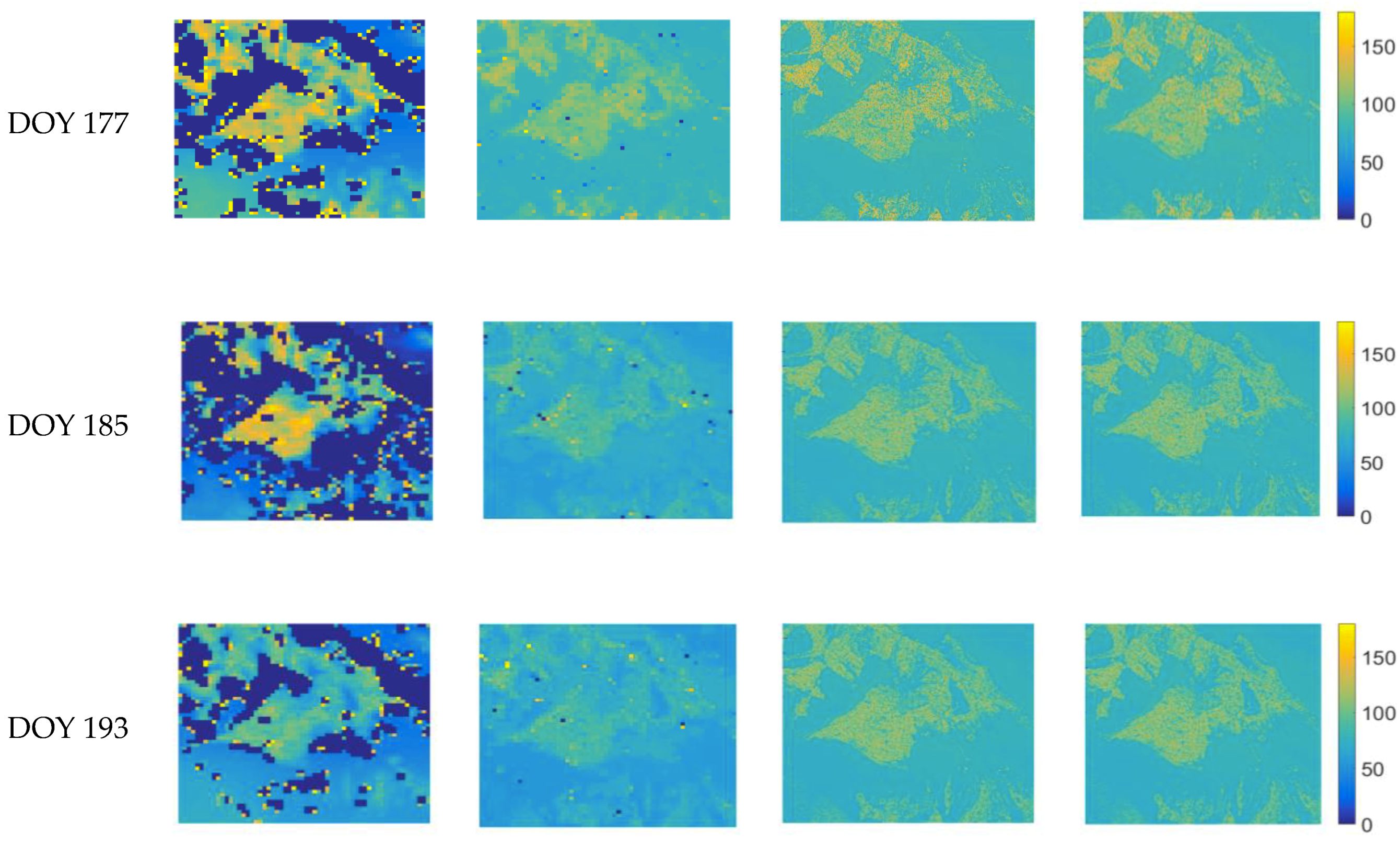
| DOY | MOD16 VS Aggregated Landsat | |||||
|---|---|---|---|---|---|---|
| Before MKF | After MKF | |||||
| Bias | RMSE | RMSE (%) | Bias | RMSE | RMSE (%) | |
| 177 | 1.13 | 32.99 | 38.60 | −1.22 | 5.37 | 6.29 |
| 185 | −4.83 | 28.57 | 39.53 | −7.49 | 11.35 | 15.70 |
| 193 | −11.06 | 24.05 | 35.18 | −13.12 | 16.25 | 23.77 |
| 217 | −8.42 | 24.77 | 28.09 | −11.52 | 17.17 | 19.48 |
| 225 | −8.20 | 29.64 | 31.97 | −10.51 | 13.50 | 14.57 |
| 233 | −11.93 | 35.58 | 49.92 | −13.10 | 17.60 | 24.69 |
| 241 | −10.32 | 35.92 | 49.81 | −11.30 | 17.16 | 23.79 |
| 249 | −9.16 | 24.56 | 52.83 | −10.33 | 14.46 | 31.11 |
© 2019 by the authors. Licensee MDPI, Basel, Switzerland. This article is an open access article distributed under the terms and conditions of the Creative Commons Attribution (CC BY) license (http://creativecommons.org/licenses/by/4.0/).
Share and Cite
Xu, J.; Yao, Y.; Tan, K.; Li, Y.; Liu, S.; Shang, K.; Jia, K.; Zhang, X.; Chen, X.; Bei, X. Integrating Latent Heat Flux Products from MODIS and Landsat Data Using Multi-Resolution Kalman Filter Method in the Midstream of Heihe River Basin of Northwest China. Remote Sens. 2019, 11, 1787. https://doi.org/10.3390/rs11151787
Xu J, Yao Y, Tan K, Li Y, Liu S, Shang K, Jia K, Zhang X, Chen X, Bei X. Integrating Latent Heat Flux Products from MODIS and Landsat Data Using Multi-Resolution Kalman Filter Method in the Midstream of Heihe River Basin of Northwest China. Remote Sensing. 2019; 11(15):1787. https://doi.org/10.3390/rs11151787
Chicago/Turabian StyleXu, Jia, Yunjun Yao, Kanran Tan, Yufu Li, Shaomin Liu, Ke Shang, Kun Jia, Xiaotong Zhang, Xiaowei Chen, and Xiangyi Bei. 2019. "Integrating Latent Heat Flux Products from MODIS and Landsat Data Using Multi-Resolution Kalman Filter Method in the Midstream of Heihe River Basin of Northwest China" Remote Sensing 11, no. 15: 1787. https://doi.org/10.3390/rs11151787
APA StyleXu, J., Yao, Y., Tan, K., Li, Y., Liu, S., Shang, K., Jia, K., Zhang, X., Chen, X., & Bei, X. (2019). Integrating Latent Heat Flux Products from MODIS and Landsat Data Using Multi-Resolution Kalman Filter Method in the Midstream of Heihe River Basin of Northwest China. Remote Sensing, 11(15), 1787. https://doi.org/10.3390/rs11151787


