1. Introduction
Cultivated land is a crucial resource and environmental factor for human survival and development. Cultivated land has multiple functions that include production, spatial bearing capacity, and environmental protection, and is a fundamental guarantee of national food security and social stability [
1,
2,
3,
4]. For a long time, with the rapid development of industrialization and urbanization and the impact of global climate change, the limited cultivated land resources have been under considerable pressure in China, which poses a great threat to food security and the ecological environment [
5,
6,
7,
8,
9,
10]. Food is the primarily need of people, and how to make use of limited cultivated land resources to guarantee food for nearly 1.4 billion people is a realistic problem in China. Food originates from cultivated land, and the core of food security is the safety of cultivated land resources. The National 13th five-year plan in China proposes adhering to the strictest systems for protecting cultivated land, adhering to the red line of cultivated land (i.e., the cultivated land minimum), implementing the strategy of rotation and fallow of cultivated land, improving the food production capacity, and ensuring basic grain self-sufficiency. Cultivated land is the basis of food and ensuring a certain area of cultivated land and steadily increasing the productivity of cultivated land is fundamental to ensure food security [
11,
12]. Therefore, the study of cultivated land productivity is of great significance for the rational use and protection of cultivated land and for ensuring national food security.
During recent years, progress has been made in the research of cultivated land productivity [
13,
14,
15,
16]. Internationally, research on cultivated land productivity has mainly focused on the potential of land productivity. During the 19th century, Liebig, a German scholar, put forward the law of the minimum factor, which began the study of the land productivity potential [
17]. Since the beginning of the 20th century, research studies on the land productivity potential have gradually shifted to a deeper level, focusing more on the impact of crop physiological mechanisms on the potential [
18]. From the 1960s to the 1970s, to establish a model between crop yield and ecological factors, the international biological program (IBP) conducted a large-scale measurement and survey of crop yield worldwide and developed an empirical and mechanistic mathematical model for estimating crop productivity based on the relationship between crop yield and environmental factors [
19]. At the same time, they initiated an upsurge in the study of crop mechanistic models which gradually led to the basic concept of estimating the crop productivity potential by using mechanistic models. Currently, with the rapid development of science and technology, research methods for studying the land productivity potential are continually improving, from simple computer calculations to the combination of 3S technology (RS, GIS, GPS) and models [
20]. Compared to international research, the research history of cultivated land productivity is relatively short and not sufficiently systematic in China. Research in China mainly centres on the macro and micro levels. Research at the microcosmic scale of cultivated land productivity is the same as that of international scholars and begins with the study of the land productivity potential [
21]. In 1950, Ren’s [
22] research on crop productivity in Sichuan marked the beginning of Chinese research on crop productivity. Subsequently, many scholars began to construct crop yield prediction models based on the crop productivity potential and to analyse crop productivity under different natural conditions such as light, temperature, soil, air, and water [
23,
24]. At the macro level, with the extensive development of agricultural land classification, many scholars have studied regional cultivated land productivity based on the results of agricultural land classification.
At present, the methods for monitoring and estimating cultivated land productivity include productivity estimations based on a statistical model, remote sensing, crop growth modelling, and combination of a crop growth model and remote sensing [
25,
26,
27]. With the rapid development of remote sensing technology, the spatial and temporal resolutions of remote sensing images have been greatly improved. Remote sensing images with high spatial and temporal resolutions can accurately and rapidly reflect a wide range of ground information and have been widely used in the estimation of crop productivity and growth monitoring [
28,
29]. The common practice of crop productivity estimation via remote sensing is to establish estimation models based on the relationship between the remote sensing vegetation index and productivity. Application of normalized difference vegetation index (NDVI) and enhanced vegetation index (EVI) in crop productivity estimation and monitoring is most extensive and practical; there is a significant correlation between NDVI and EVI, and agricultural productivity has been widely proven by scholars [
30,
31,
32]. Maselli et al. [
33] used MODIS NDVI data to estimate the wheat planting area and yield in Tuscany, Italy, and compared them with provincial statistics. The results showed that there was a high consistency between the estimated and reported values. Using MODIS NDVI and wheat yield data, BeckerReshef et al. [
34] established an empirical model for wheat yield prediction. David [
30] used MODIS NDVI data to monitor crop changes and estimate U.S. maize and soybean yields. The results showed that NDVI had a significant positive correlation with crop yields. Using EVI and wheat yield data, Wang et al. [
32] established a yield prediction and growth monitoring model for winter wheat in the U.S. and then verified the prediction results and showed that the model achieved excellent results. Compared to NDVI, EVI improves the sensitivity of estimating the canopy biomass of dense vegetation, reducing the impact of atmospheric and soil reflection, and avoiding the saturation problem of vegetation indexes based on a ratio. Previous studies have shown that EVI is more effective in crop monitoring and productivity estimations [
32,
35].
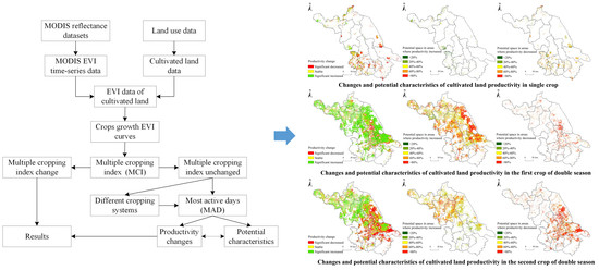
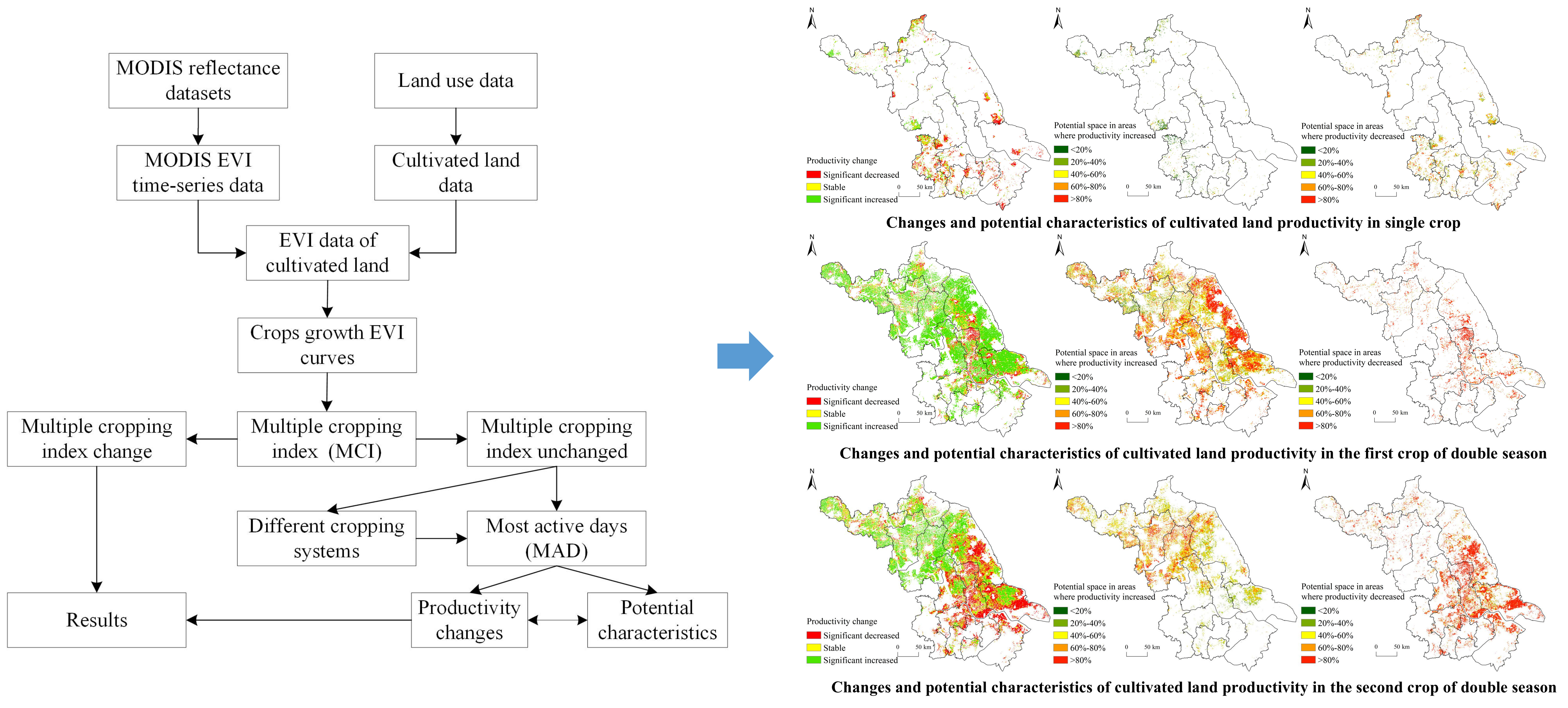
From the above summary, it is clear that abundant achievements and apparent effects have been obtained in monitoring and estimating cultivated land productivity via remote sensing. However, current estimations of cultivated productivity with remote sensing are mostly based on a specific region, and different regions have different environmental characteristics, which makes the established estimation model lack applicability and generalizability. Most current studies regarding the estimation and changes of cultivated land productivity are aimed at the whole production process of cultivated land, without considering the changes in cultivated land productivity in different cropping systems and during different production stages. Therefore, this study selected Jiangsu Province, the main grain-producing area in China, as the study area. Using MODIS EVI data and land use data to reconstruct crop growth EVI curves, based on the generated EVI curves, this study extracted the multiple cropping index (MCI) and calculated the most active days (MAD) to characterize the cultivated land productivity and explored the changes and potential characteristics of cultivated land productivity under different cropping systems. The study results have practical application value for protecting cultivated land, guiding agricultural production, and ensuring national food security.
4. Discussions
Cultivated land productivity refers to the productivity of crops under certain conditions. The relevant research indicates that cultivated land productivity is subject to the dual constraints of natural conditions and socioeconomic conditions [
43,
44]. Natural factors mainly include the quantity and quality of cultivated land, climate, water, topography, land degradation, etc., whose changes directly affect cultivated land productivity. Compared to other natural factors, climate and land degradation are considered to be important factors that affect changes in agricultural productivity [
45,
46]. Regarding climate, its influence on agricultural production can be divided into two categories: the effect of inter-annual climate variation on agriculture and the impact of extreme weather events (drought, floods, typhoons, etc.) on agricultural production. Notably, the impact of inter-annual climate change on agricultural production is uncertain and different regions have different responses to climate change. For example, research has indicated that a higher temperature can significantly increase the productivity of cultivated land in Northeast China, but reduces productivity in South China [
47,
48]. However, the negative impact of extreme climate conditions on cultivated land productivity has been unanimously recognized and agricultural disasters significantly reduce food production [
49].
In addition, land degradation is a global phenomenon causing a decrease in the productive capacity of the land. Approximately 25% of the world’s land surface is considered to be degraded; every year, 12 million hectares are added to the total area of degraded land [
50]. Land degradation results from unreasonable exploitation of natural resources, which causes the destruction of vegetation, a decrease in soil erosion resistance, and thinning of soil layers and the bedrock exposure in many areas, resulting in a reduction in cultivated land, a decrease in productivity, and a threat to food security [
46]. Land degradation is common in areas of intensive crops and would diminish potential increases in production in affected areas.
In addition to natural factors, cultivated land productivity is also affected by socioeconomic development. There developments affect productivity according the level of agricultural production inputs, such as land, labor, capital, and technology inputs [
51]. As previously mentioned, cultivated land productivity is affected by many factors, and the influences are comprehensive and complex. In this study, it is undeniable that the factors that influence cultivated land productivity, as previously mentioned, have a certain impact on the research results. However, because of the limitations of the data sources and research methods, the aforementioned factors are not included in the scope of this paper. Moreover, the purpose of our work was to provide new insight into studying cultivated land productivity and detecting potential productivity. Therefore, the causes of the changes in productivity are not an objective of this study and need to be explored in a follow-up study.
In addition to the issues previously mentioned, there are still some deficiencies in this study. First, the MAD of different crops cannot be simply compared; at the same time, there is a lack of large-scale and high-precision crop classification data. Therefore, the preconditions of this study are that the crop types remain unchanged during the study period and that only the crop productivity changes and potential characteristics in the invariant areas of MCI were explored, not all cultivated land. Second, only the MODIS grid cells which the cultivated areas accounted for over 75% of the entire areas were maintained for further analysis in this study. Hence, given the level of homogeneity in the valid grid cells, we supposed that MODIS had sufficient resolution. Third, MODIS EVI with a spatial resolution of 500 m was used as the basic data. Mixed pixels are unavoidable in medium resolution satellite remote sensing images. As a result, EVI extracted by pixel may be a mixture of multiple crops in multiple plots which will interfere with the reconstructed EVI growth curves and lead to errors in the extraction of the MCI and MAD. The aforementioned shortcomings are subject to further improvements and modification in subsequent research.
5. Conclusions
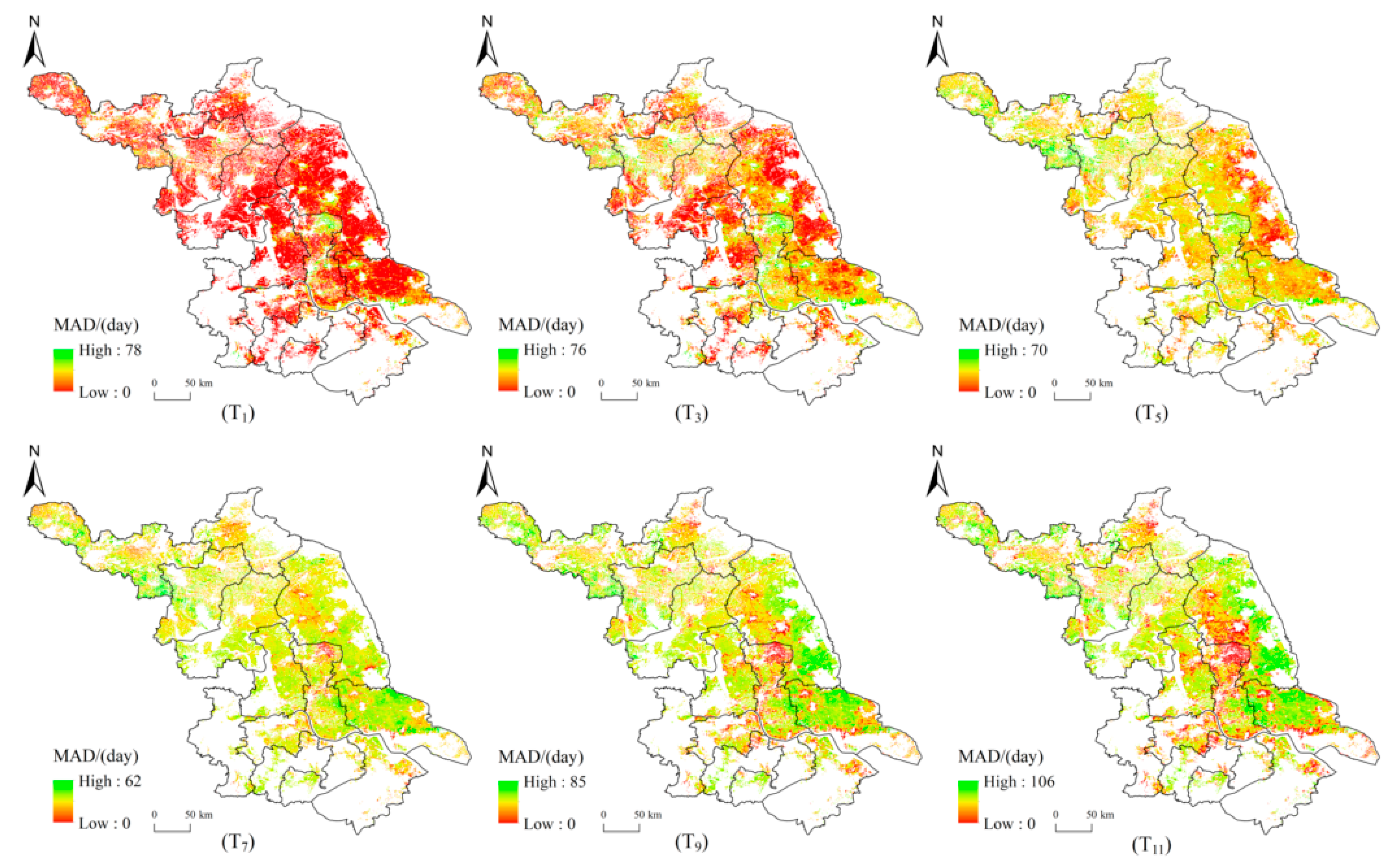
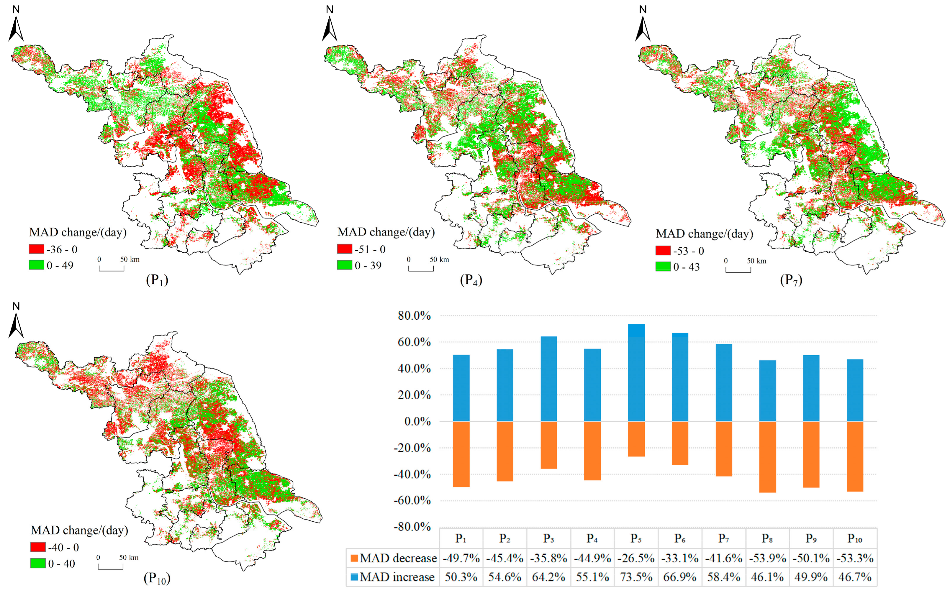
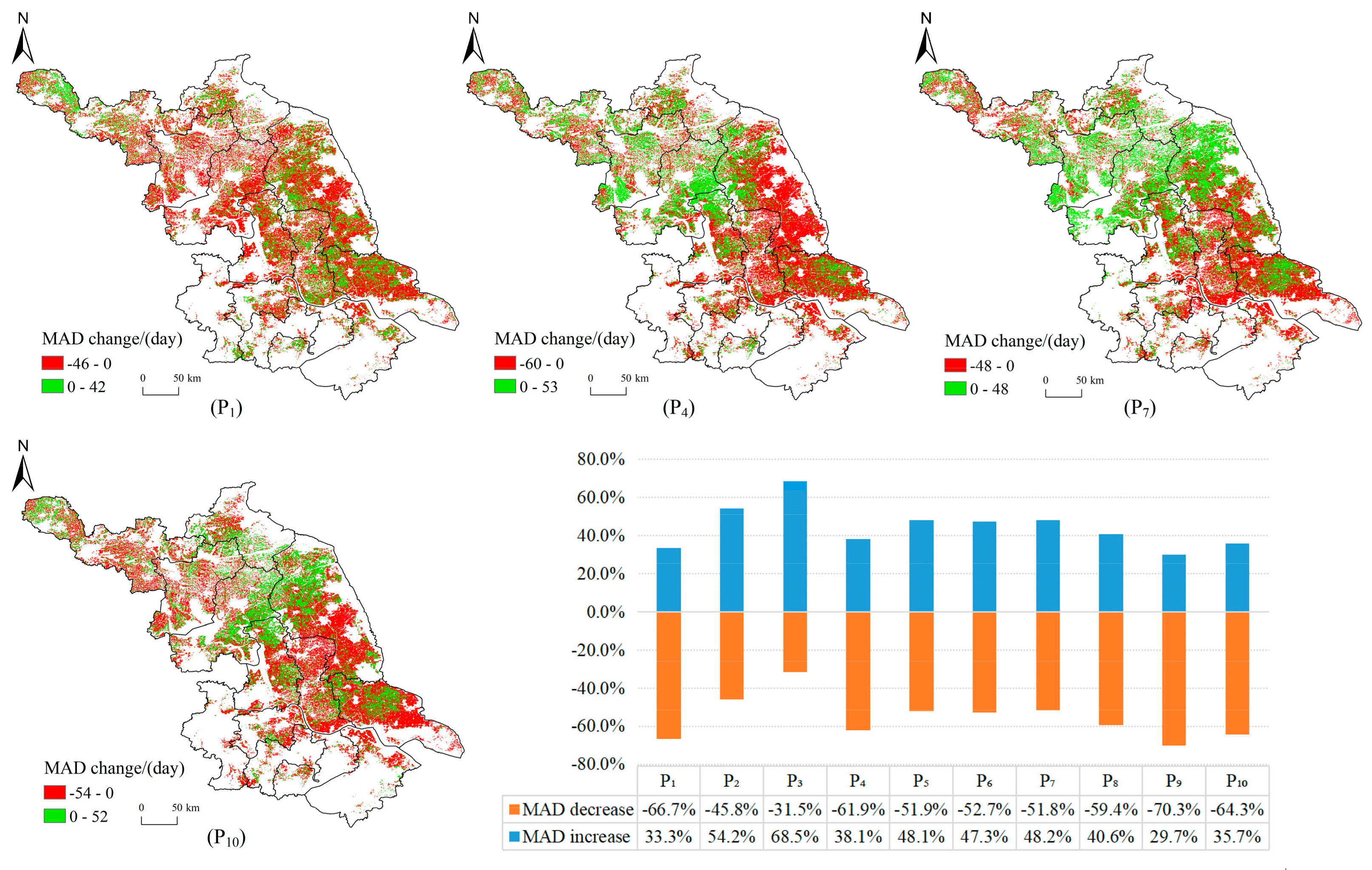
In this paper, the changes and potential characteristics of cultivated land productivity in Jiangsu Province during the period 2001–2017 were explored based on the multiple cropping index (MCI) and most active days (MAD), which were extracted using a difference algorithm and threshold method based on MODIS EVI.
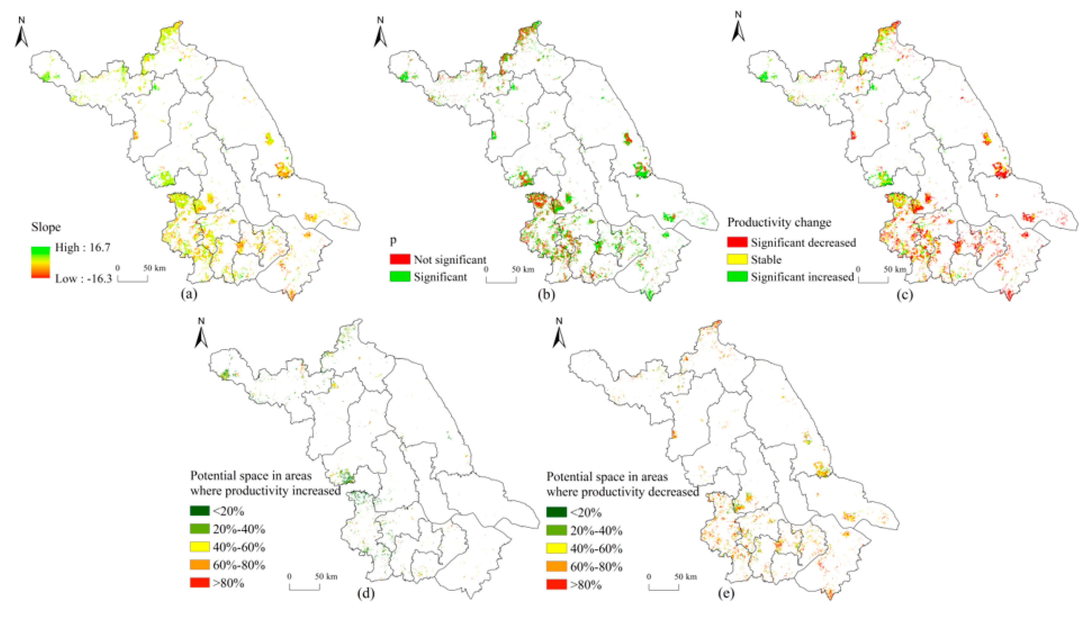
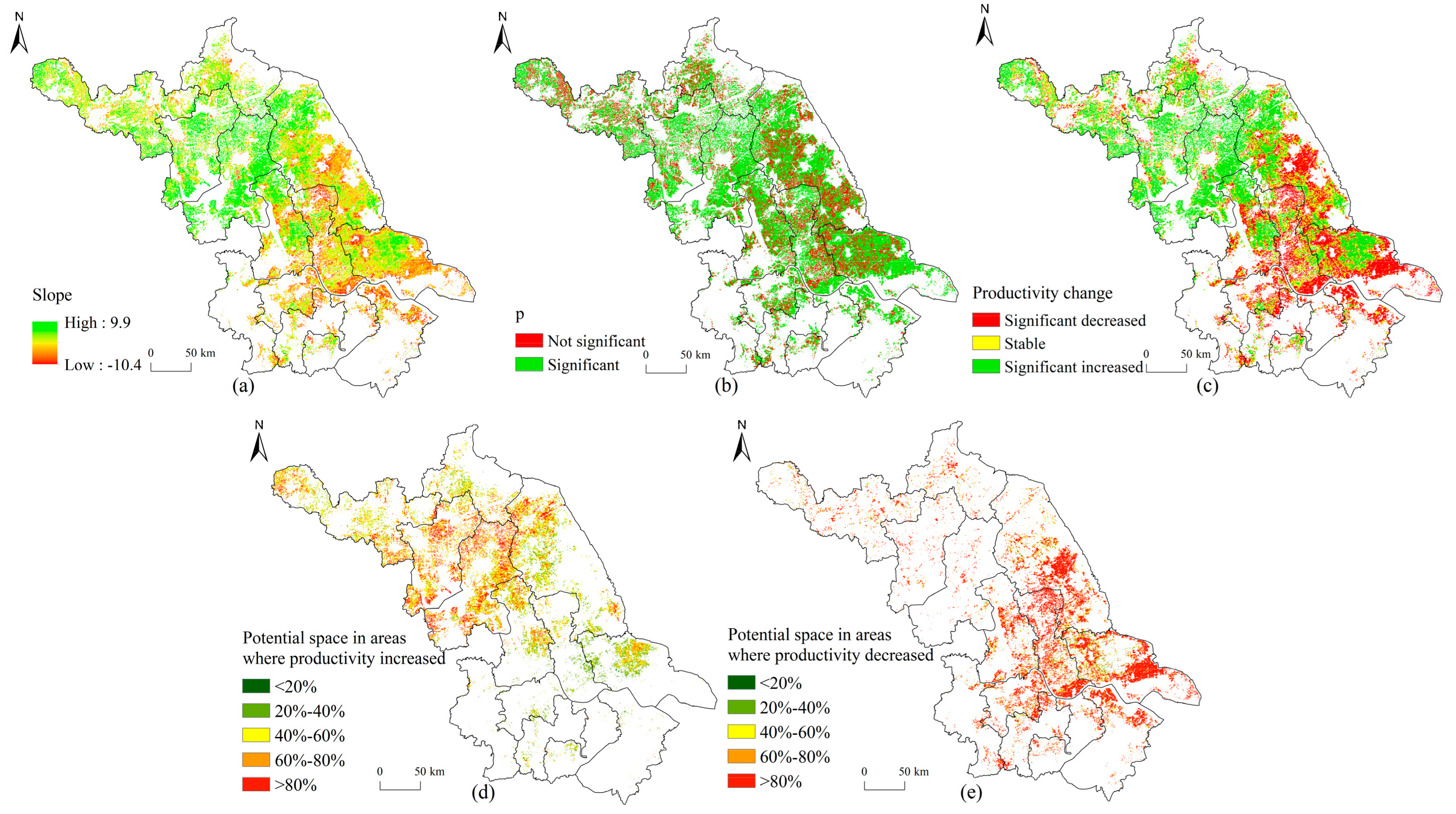
This study suggested that the cropping systems were dominated by single and double cropping systems in Jiangsu and that the changes in cultivated land productivity were obvious and had distinct spatial distribution features during the study period. The areas where productivity changed for single cropping system occupied 67.8% of the total cultivated land of single cropping system. The areas where productivity decreased accounted for 46.5% and were primarily concentrated in southern Jiangsu. The percentages of the areas where productivity increased and stable were 21.3% and 32.2% of cultivated land, respectively. For double cropping systems, the productivity of most cultivated land (82.7% and 73.3%) changed, and the decreased areas (10.7% and 32.5%) were distributed in central Jiangsu. In addition, the first crop was dominated by a productivity increase, and the areas where productivity increased (40.8%) for the second crop were largely in northern Jiangsu. Through estimation of the productivity potential space, we found that the cultivated land productivity had great potential space in Jiangsu. In areas where productivity increased, greater than 60% and 90% of cultivated land had potential space in more than 20% of the single and double cropping systems, respectively. Notably, the percentages of cultivated land with a productivity potential space more than 80% in the single and double cropping systems were greater than 25% and 75%, respectively, in areas where productivity decreased. This indicated that the cultivated land productivity still had a greater potential for improvement.
Based on a remote sensing vegetation index combined with the growing process of crops, this study used the MAD as an indicator of cultivated land productivity to study the changes and potential characteristics of productivity. Our work provides new insight into the study of cultivated land productivity and is significant for improving cultivated land productivity and agricultural production. Also, our work can serve as a reference to study cultivated land potential for food security. More importantly, as a large agricultural province with an economically developed area in eastern China, Jiangsu Province serves as a good example of regional development for other areas in China and developing countries throughout the world. Particularly, our work presents a typical case study for assessing cultivated land productivity and potential based on agricultural production and economic development. Therefore, we envision our work will be used to explore cultivated land productivity in broader areas and supply references for the study of cultivated land productivity in other areas.

 ,
, 


