Article

Re-Discovering Ancient Landscapes: Archaeological Survey of Mound Features from Historical Maps in Northwest India and Implications for Investigating the Large-Scale Distribution of Cultural Heritage Sites in South Asia

by
Adam S. Green
1,*,
Hector A. Orengo
2,
Aftab Alam
3,
Arnau Garcia-Molsosa
1,
Lillian M. Green
1,
Francesc Conesa
1,
Amit Ranjan
3,
Ravindra N. Singh
3 and
Cameron A. Petrie
4
1
McDonald Institute for Archaeological Research, University of Cambridge, Cambridge, CB2 3ER, UK
2
Catalan Institute of Classical Archaeology, Tarragona, 43003, Spain
3
Department of AIHC and Archaeology, Banaras Hindu University, Varanasi, 221005, India
4
Department of Archaeology, University of Cambridge Cambridge, CB2 3DZ, UK
*
Author to whom correspondence should be addressed.
Remote Sens. 2019, 11(18), 2089; https://doi.org/10.3390/rs11182089
Submission received: 8 August 2019 / Revised: 26 August 2019 / Accepted: 3 September 2019 / Published: 6 September 2019

Abstract

:
Incomplete datasets curtail the ability of archaeologists to investigate ancient landscapes, and there are archaeological sites whose locations remain unknown in many parts of the world. To address this problem, we need additional sources of site location data. While remote sensing data can often be used to address this challenge, it is enhanced when integrated with the spatial data found in old and sometimes forgotten sources. The Survey of India 1” to 1-mile maps from the early twentieth century are one such dataset. These maps documented the location of many cultural heritage sites throughout South Asia, including the locations of numerous mound features. An initial study georeferenced a sample of these maps covering northwest India and extracted the location of many potential archaeological sites—historical map mound features. Although numerous historical map mound features were recorded, it was unknown whether these locations corresponded to extant archaeological sites. This article presents the results of archaeological surveys that visited the locations of a sample of these historical map mound features. These surveys revealed which features are associated with extant archaeological sites, which were other kinds of landscape features, and which may represent archaeological mounds that have been destroyed since the maps were completed nearly a century ago. Their results suggest that there remain many unreported cultural heritage sites on the plains of northwest India and the mound features recorded on these maps best correlate with older archaeological sites. They also highlight other possible changes in the large-scale and long-term distribution of settlements in the region. The article concludes that northwest India has witnessed profound changes in its ancient settlement landscapes, creating in a long-term sequence of landscapes that link the past to the present and create a foundation for future research and preservation initiatives.

Graphical Abstract

1. Introduction

Archaeological site locations are an essential dataset for investigating the long-term and large-scale transformations of cultural and social landscapes. Wilkinson [1] argued that as social processes change, they materialize different ‘signature landscapes,’ the comparison of which can reveal the dynamics of past human societies. Past settlement landscapes associated with early cities and polities are particularly extensive by their nature. Investigating these landscapes therefore requires data from across large areas, but the process of locating ancient cultural heritage sites through archaeological survey is expensive in terms of both time and resources. Surveys are best employed in concert with other spatial research methods, which can be used to build up datasets that allow research over long periods of time and over extensive areas [2,3,4]. Historical maps are one such dataset, offering information from a range of periods that can complement remote sensing-based approaches to identifying cultural heritage sites [5]. This article presents the results of archaeological field surveys designed to ground truth a GIS-based analysis of 1” to 1-mile maps produced by the Survey of India from the early twentieth century, and reveals a sequence of ancient landscapes that have not previously been reported or recognized.
South Asia has been home to complex societies for over four millennia [6,7,8,9,10,11], but analysis of its signature landscapes remains in a preliminary state. One reason for this lacuna is that settlement distribution data from past societies in South Asia are incomplete [4,12,13,14]. In many parts of the world, remote sensing approaches have extended the spatial and temporal range of archaeological investigations, allowing researchers to examine larger areas and identify potential archaeological sites [1,15,16,17,18]. However, systematic remote sensing data are constrained to the last 40 years or so and early aerial photography that covers a longer time-span is not available for many study areas. This limitation is an acute problem, especially in regions that have undergone extensive development in the last century. Historical maps can therefore enhance remote sensing datasets. The colored Survey of India 1” to 1-mile maps, produced from the start of the twentieth century, are of high-quality and documented the location of towns, canals, roads, and topographic features, with the aim of improving military intelligence and increasing colonial control [5]. These maps advanced British imperial ambitions, but they also preserved a wealth of information about the landscapes these early surveyors encountered. They can be used to identify landscape transformations at particular points in the past, such as the historical transformations that unfolded as the city of Dera Ghazi Khan was destroyed by changes in the Indus River’s floodplain [19].
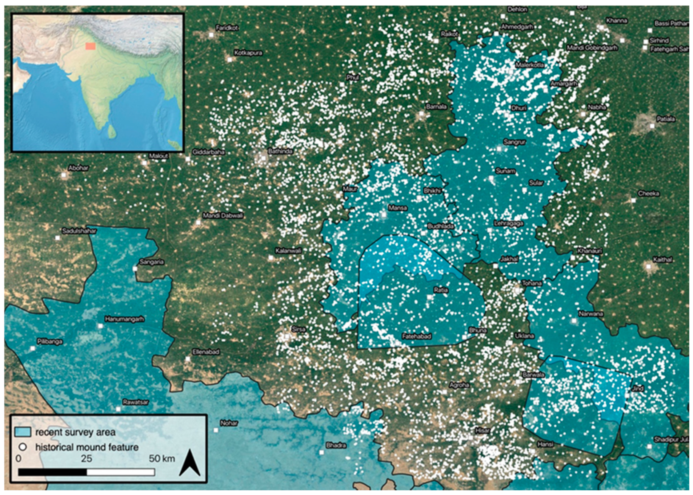
This article presents the results of archaeological surveys that were carried out as part of the TwoRains project, an integrated research project that considers the relationship between the Indus Civilization and climate change in northwest India. A previous study of a selection of these historical maps has revealed the location of nearly nine-thousand historical map mound features distributed across much of the modern Indian states of Haryana and Punjab (Figure 1) [5]. Given the early date at which these maps were composed, variability between individual maps, and ambiguity in their symbologies, some of the features they recorded may not have been archaeological sites or may no longer be present. The total number of reported archaeological sites located through archaeological surveys in the area covered by the Survey of India maps has grown steadily since the 1960s [4,20,21,22,23], but a generous count would yield only around two-thousand reported sites in northwest India. Many of these locations were recorded prior to the use of global positioning systems (GPS) devices, and a large proportion of the reported geographical coordinates could be inaccurate or duplicates [4]. These data are of high potential value for archaeological investigation and preservation initiatives, but it is unknown what proportion of the mound features seen in the 1” to 1-mile maps are extant archaeological sites, other kinds of landscape features, or sites and features that have since been destroyed. For those that are extant sites, it is unknown to which chronological period(s) they may belong. Before this important dataset can be integrated with remote-sensing approaches to contribute to debates about settlement distributions and signature landscapes in northwest India, it must be ground truthed strategically to ensure its accuracy and precision. Toward this end, two seasons of extensive archaeological survey were carried out to ground truth a sample of these historical map mound features. The results of these surveys reveal the location of numerous heritage sites, making them available for future study and preservation, and provide crucial insights into the scale and dynamism of the region’s archaeological landscapes. They also provide substantial corpus of location data that can be used to augment future remote sensing studies and provide important spectral signatures for specific types of archaeological sites for the implementation of ongoing automated site detection procedures.

1.1. Historical Maps, GIS and Remote Sensing

Historical maps have the potential to complement other spatial research techniques, such as remote-sensing, thereby facilitating holistic investigations of archaeological landscapes [5,24,25,26]. Geographical information systems (GIS)-based methods are essential to transforming old and sometimes forgotten documents into spatial data for multi-method analyses that include sources that are difficult to compare as discrete documents [27,28,29,30,31]. GIS allows maps, plans and other features to be transformed into digital vector data with spatial coordinates—points, lines and polygons that can store additional attribute values along with x, y and z coordinates. Vector data can be extracted from historical documents and integrated with those from other sources (e.g., [32]), such as remote sensing data (e.g., [19,26]), and importantly, can be combined with digital navigation tools to facilitate archaeological fieldwork. Many GIS tools are open source and open access, and can be combined with other accessible data sources such as Google Earth Imagery, dramatically improving the resolution of cultural heritage landscape data in many parts of the world [33,34,35].
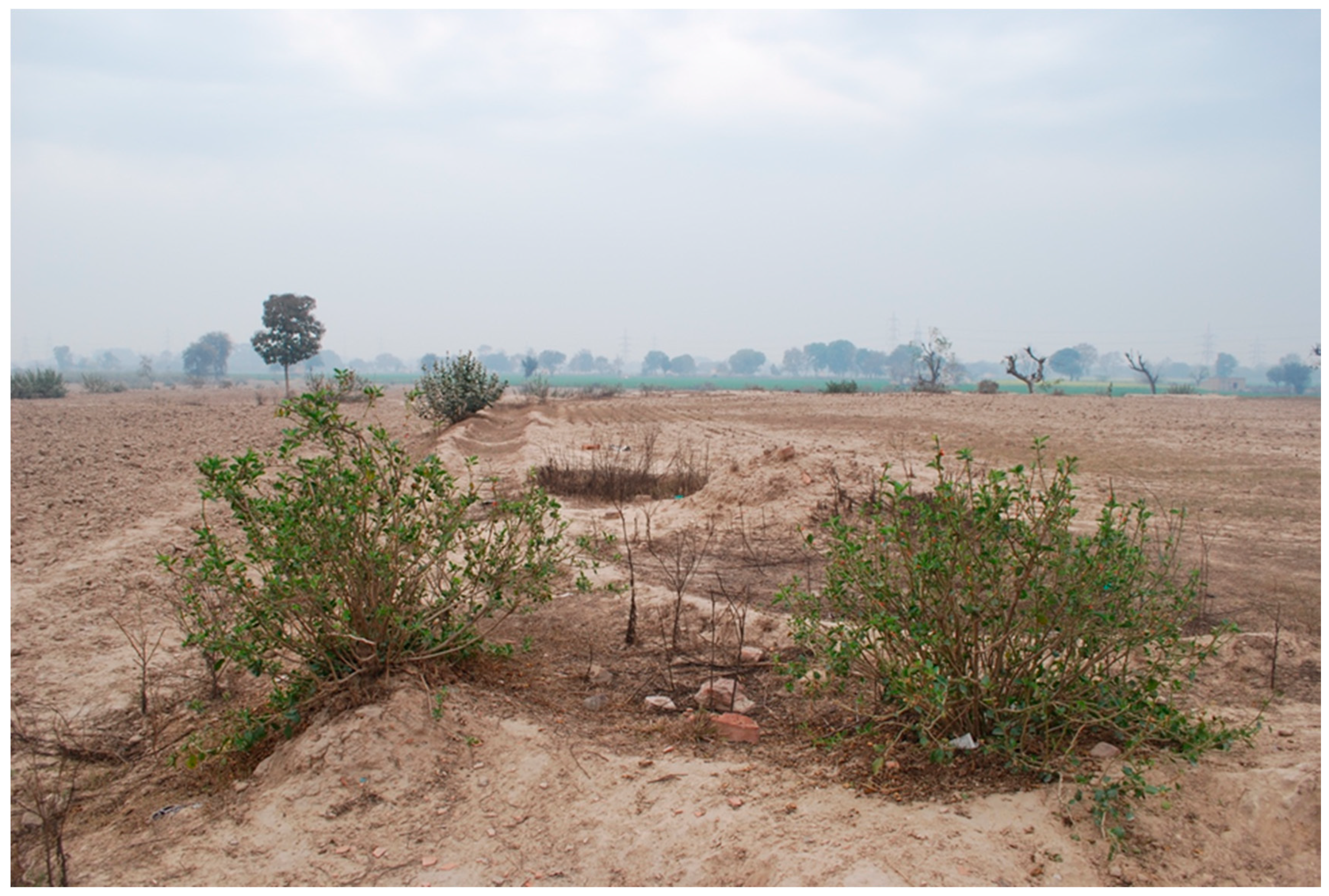
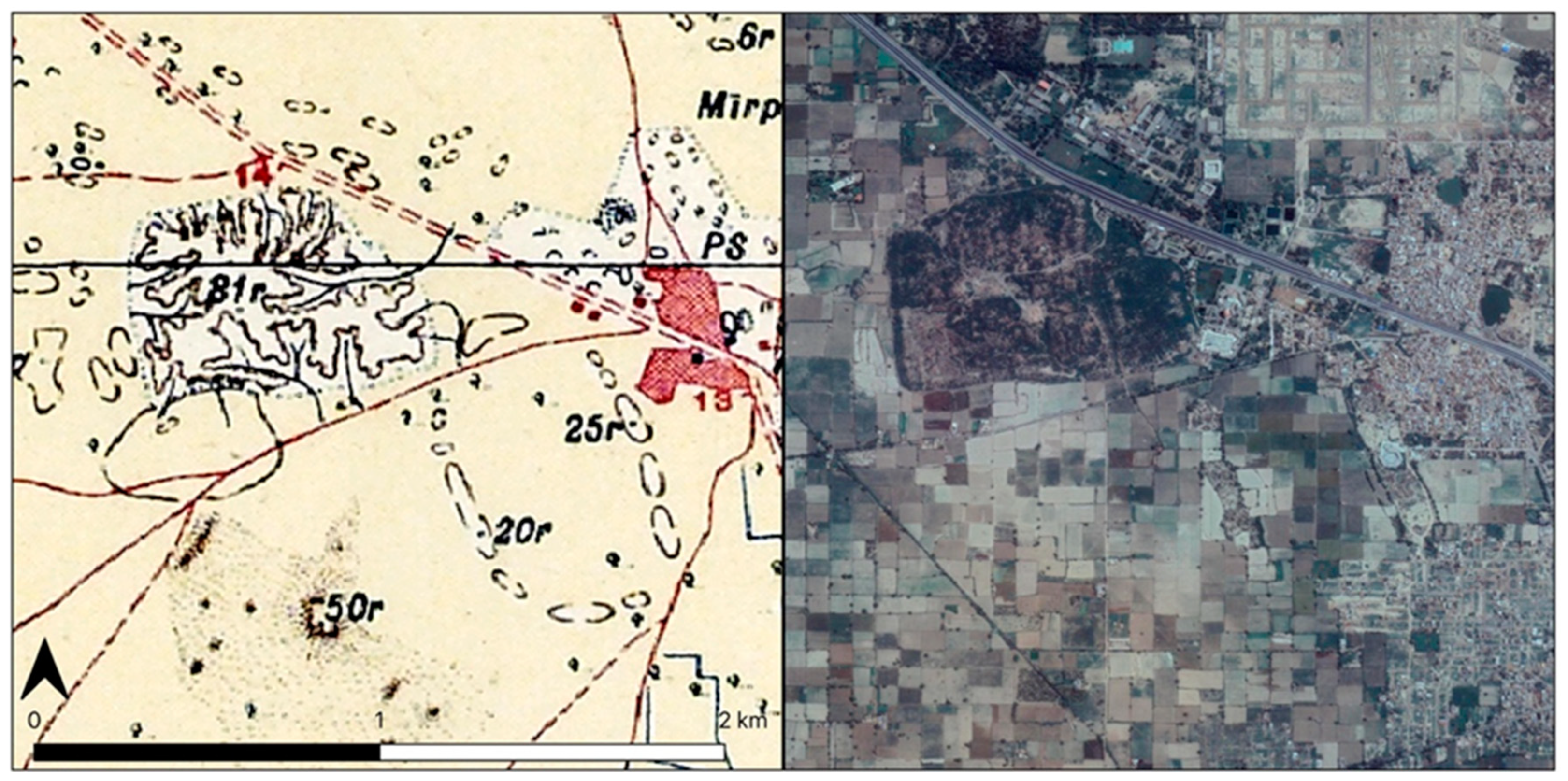
Unlocking the potential of the Survey of India 1” to 1-mile map series to facilitate landscape research in northwest India requires a multi-stage GIS-based approach. In an initial phase of research, 64 maps were geo-referenced (Figure 1), geo-rectified, and systematically searched for symbols that may refer to archaeological sites. This initial study provided the underlying data that was used in the present article, and is described at length in a separate article (e.g., [5]). In this foundational study, map scans were georeferenced using tools found in either ArcGIS or QGIS. A minimum of 20 ground control points were created by comparing mapped features such as canals, railroads and village blocks to world imagery sources. Second order polynomial and the “adjust” transformation in ArcMap were then used to transform the scans. Low root mean square errors were attained through these transformations. These georeferenced maps were then searched systematically for features of archaeological potential. Many archaeological sites in South Asia, especially those that were established following the emergence of its first sedentary agro-pastoral communities, take the form of elevated mounds that rise above the surrounding plains (Figure 2). These kinds of landscape features were typically denoted by Survey of India cartographers using shading, form-lines, hachures, or a combination of the three (Figure 3 and Figure 4) [5]. Systematic georeferencing and examination of these maps made it possible to extract the location of a large number of such features, which were tabulated along with the spot-height, symbol-type, and approximate size category of the feature in question (1: 0–200 meters, 2: 200–400 meters, 3: >400 meters). The resulting table included almost 9,000 of these historical map mound features, many of which could correspond to archaeological sites [5].
Once the utility of the historical map mound features has been established through ground truthing, these data can be integrated into studies that incorporate aerial imagery and remote sensing approaches to address some of the limitations of these techniques. Archaeologists have employed aerial imagery for archaeological prospection and documentation for over a century [36,37]. Satellite and aerial remote sensing approaches have revolutionized the search for archaeological sites in many areas [1,18,38]. These site discovery techniques greatly enhance researchers’ ability to locate archaeological sites that are associated with different periods in the past [1,15,16,17,18,39,40], particularly those located in remote or inaccessible regions [41,42,43,44,45]. While remote sensing approaches have been employed in South Asia [46,47,48,49], their applications remains limited, and the most popular sources of data for remote sensing analysis (e.g., Corona, Gambit and Hexagon Key Hole program, Landsat, ASTER, Ikonos, Copernicus) have a range of limitations, the most important being that they were only acquired from the 1950s onward and only specific areas were covered [5]. The potential of remote sensing approaches is also constrained in areas undergoing rapid large-scale development, which can bring about substantial transformations in the present landscape. In northwest India, the flattening of the landscape in service of irrigation agriculture can make it difficult to distinguish archaeological sites from other landscape features that have similar remote sensing signatures. Integrating historical maps into investigations of these landscapes can help address both limitations [5].

1.2. Archaeological Survey in Northwest India

The plains of northwest India stretch across the states of Rajasthan, Haryana and Punjab. The region played a key role in the formation of the Indus Civilization (c. 2600–1900 BC) [11,50], which emerged across the Indus River Basin and surrounding regions, and was one of the world’s earliest urban societies. The Indus Civilization was comparable in scale and complexity to contemporaneous polities in southern Mesopotamia and Egypt [9], though there is evidence that it encompassed a larger and more varied geographical area [21,50]. Five large sites have been located across the Indus Civilization’s extent, each of which has been identified as a city [6,7,10,51,52,53], and each city lies in a contrasting environmental setting, suggesting that environmental diversity played an important role in South Asia’s first urbanization [50]. The great majority of the Indus Civilization’s settlements appear to have been smaller than 20 hectares, indicating the importance of its rural communities [50,52,54,55,56].
The fact that northwest India continued to play an important role in the long-term social trajectory of South Asia long after Indus settlements had been abandoned has often been overlooked. Surveyors cannot (and should not try to) choose the chronological periods associated with the sites that they encounter. Investigations that have focused on Indus sites have also produced the locations of hundreds of sites from later periods, such as the historical Early Historic and Medieval periods. In some cases (e.g., [57,58]), the number of these later sites, which tend to be larger and better preserved than their protohistoric counterparts, far exceeds that of Indus-related sites reported. This pattern is not surprising, as the plains of northwest India have provided a rural hinterland to many of South Asia’s subsequent polities, states, and empires. The region formed an important geographical link between major population centers in the Gangetic Basin and the Indus plains in later phases. By the Early Historic period, large-scale cities had been re-established on the plains of northwest India, likely including Indraprastha, an early settlement that is argued to have become today’s Delhi [59]. A series of successive polities, including Ashoka’s Mauryan Empire (324–187 BC), extended their influence over increasingly extensive territories, bringing them under the political control of capitals based thousands of kilometers away [60]. At the start of the long Medieval period, major cities such as Agroha [61] were established in the region (Figure 3). Each of these societies materialized signature landscapes that built upon and transformed the landscape of its predecessors.
Though there has been a significant number of extensive archaeological surveys across the extent of the Indus Civilization [20,54,55,57,62,63,64], northwest India remains arguably the most surveyed part. The region marks the Indus Civilization’s easternmost extent, though there is no environmental boundary between the plains of northwest India and those of Pakistan’s Punjab province to the west, where Harappa is located along a major tributary of the Indus River. The distribution of villages across northwest India begins at the northern edge of the Thar Desert, where dunes co-occur with arable inter-dunal areas, and continues into wetter parts of Haryana and Punjab, both of which receive water from winter and summer rainfall systems [50]. Northwest India was a key setting in the Indus Civilization’s de-urbanization. A weakening of the Indian summer monsoon appears to have prompted a two centuries-long process beginning c. 2100 BC, after which there is evidence that the number of small settlements in northwest India increased in some areas [65,66], though the increase did not have a uniform impact on the entire region and some areas were favored over others [4,50]. This pattern suggests that the region was particularly conducive to rural resilience and long-term sustainability [50,67].
Two major phases of archaeological survey generated most of northwest India’s substantial site location dataset [4]. Suraj Bhan [68,69] led a period of extensive archaeological surveys, and many subsequent scholars, including Amar Singh [70], adopted Suraj Bhan’s approach, contributing hundreds of site location reports to the corpus of Indus settlement location data. Much of this work was initially presented in Indian Archaeology: A Review, and ultimately collated in early studies of the Indus Civilization’s settlement distribution [20]. By this time, ‘village-to-village’ survey techniques had become well-established in Indian universities, which undertook efforts to survey the entire region one administrative unit at a time—be they districts, blocks, or tehsils [4]. Additional surveys were undertaken by MPhil and PhD students beginning in the 1990s. Many of these have not been formally published, and exist only as single-copy manuscripts in university libraries, though there have been efforts to synthesize this work and make it available to broader scholarship (e.g., [22,23,71]). Excavations at sites throughout northwest India [69,72,73,74,75,76,77,78,79,80] established their contemporaneity with the Indus cities in Punjab and Sindh in Pakistan. Most significant was the identification of Rakhigarhi as one of the Indus Civilization’s five known cities [69].
A second period of archaeological surveys began with the advent of GPS technology. The Indus Project, for example, undertaken by the Research Institute for Humanity and Nature in Kyoto, collaborated with South Asian institutions to undertake a series of surveys, including reconnaissance in northwest India (e.g., [78,81]). At the same time, the Land, Water and Settlement (hereafter LWS) project began an extensive investigation of the small-scale sites that typify Indus settlement in northwest India [12]. LWS conducted two extensive surveys, one in the region immediately surrounding Rakhigarhi [64] and one over a broad area surrounding the course of the Ghaggar River in northern Haryana [57]. As the use of GPS became well integrated into archaeological survey techniques, the number of reported sites continued to rise in northwest India, and major survey projects were carried out throughout the region [71,82,83,84,85,86]. These projects resulted in an aggregate dataset of around two-thousand site locations, which had been reported with the aid of GPS in northwest India and spanned all of the periods in which the region was known to have been occupied [4]. Even these locations, which were more precise than those that had been collected prior to 2010, are not without their problems, as the data were collected by different teams using different methods [4], and there are a number of simple reporting errors in the dataset [57,64].

1.3. Survey of India Maps and Northwest India

The initial analysis of the Survey of India 1” to 1-mile map series for the TwoRains project produced a corpus of nearly nine-thousand mound features distributed across a large part of northwest India that could be archaeological sites [5] (Figure 5). There is little or no apparent patterning in the distribution of particular types of features, with concentrations of shaded, hachure, and form-line features occurring to varying degrees across the maps. The area covered by the maps does not directly correspond to that covered by archaeological surveys, and reveals historical map mound features in areas that were ostensibly un-surveyed. Confirmation that many of these historical map mound features are extant archaeological sites could transform knowledge of South Asia’s ancient landscapes.

2. Materials and Methods

A sample of 779 historical map mound features found in the initial study tabulation [5] were visited in the field to determine whether an archaeological site was present and assess the age of any material culture visible on the surface of the possible mounds. These field surveys constituted the second phase of research aimed at developing the historical maps as a data source for subsequent studies of South Asia’s archaeological landscapes (Figure 6). They were undertaken over two field seasons in 2017 and 2018. The survey team conducted extensive surveys across areas where many historical map mound features are located [58,87]. These surveys were systematic and comprehensive, drawing on an arbitrary hexagonal grid of 100-square-kilometre regional grid units (RGUs) and incorporating additional locations from previous surveys, Google Earth imagery, and local informants into its regional sampling strategy. The survey’s workflow was digital; field activities were organized using QGIS (qgis.org), locations were visited by navigating to them using the Android App AlpineQuest, and all data (including locations and notes specific to each location) were collected via Open Data Kit (opendatakit.org). During fieldwork, historical map mound features that fell within a sampled RGU were selected using a GIS and exported with their geographical coordinates as comma-separated-values (.csv) files. These tables were then imported into AlpineQuest, which projected these locations on Google Satellite and Google Maps basemap layers. This integrated cross-platform process allowed the team to identify a route to each location in the field, and assess the presence or absence of an archaeological site.
The survey sought to address a range of questions by linking the settlement distributions produced by previous surveys projects so that large areas could be analyzed. The four objectives were to: (1) verify and enhance the results of earlier surveys by re-visiting previously identified sites [58]; (2) identify new archaeological sites through village-to-village survey in areas of poor coverage; (3) check the signatures of archaeological sites in remote-sensing data and remote-sensing-derived datasets; and (4) visit the locations of historical map mound features to determine whether they corresponded to archaeological mounds. This paper addresses the fourth objective, explicitly considering how well the mound features identified on the historical maps corresponds to present site locations.

2.1. Study Area

The surveys included areas where many historical map mound features were located (e.g., 44O9). In some of these areas, few or no archaeological sites have been previously reported, which suggests that there are vast numbers of archaeological sites that are yet to be surveyed in northwest India. Areas where few historical map mound features have been reported were also surveyed (e.g., 53C2). The surveys examined patterns recorded in the distribution of mound features, such as a linear concentration running from the southwest to northeast of some maps (e.g., 44O9), and dense concentrations of mound features located around Tohana (44O14). There was also a linear concentration extending away from Tohana and a similar linear concentration to the north and west that progresses across multiple map sheets, indicating that the maps may depict some underlying patterns in settlement distribution. The concentration of historical map mound features declines toward the southwest of the survey area (Figure 7), as the heavily irrigated agricultural land of Haryana gives way to the sand dunes on the margins of Rajasthan.

2.2. Filtering Criteria

The RGUs that make up the study area were compiled into a single GIS that was used to implement the field survey (Figure 7). For each RGU, layers that included historical features and previously reported sites within a particular RGU were generated and then visited in the field (Figure 8). After compiling the historical map mound features table for a particular RGU, the data were then filtered to ensure that features belonging to a range of categories and were distributed throughout the RGU were visited.
The survey procedures progressed over the course of the two survey seasons. In the initial phase of the survey, all historical map mound features that were in the size-2 or size-3 categories (>200 meters across) were assessed [58]. Next, a sub-sample of features in the size-1 category that were distributed throughout the RGU were visited until ten were found to lack traces of archaeological sites. This often meant that every historical feature identified in an RGU was visited, but in some instances, several size-1 historical features were not tested. It became clear that the smallest historical map mound features were rarely associated with extant archaeological sites, so in 2018 the filtering criteria were modified [87]. The survey continued to ground truth all size-2 and size-3 features, but the size-1 features were reviewed for a second time prior to visiting them in the field. The corresponding Survey of India 1” to 1-mile map was rechecked, and features with symbols that apparently did not correspond to archaeological sites (i.e., when a landscape feature was present hachure features adjacent to villages were sometimes ponds (n = 12) and shaded features were often dunes (n = 42)) were omitted from field visits. Instead of completing the testing at 10 negative location visits, the team continued to survey these ‘medium-probability’ locations until all had been visited. Once a sufficient number of features had been tested, the team marked the RGU as complete.

2.3. Field Assessments

Most of the land in northwest India is presently organized into square 1-acre plots, which are divided by irrigation ditches that are watered either by large-scale canals or pumps from tube wells (Figure 9). While the scale of crop production is today quite large, most agricultural work is completed using hand tools. As such, pedestrian-level access to most fields is generally good. Access to fields and to some ground surfaces was provided by access roads and irrigation ditches. In some instances, there were obstacles interrupting potential transects through fields, so the field assessment process retained a degree of flexibility. In both survey seasons, high crops limited visibility, but it was possible to assess at least a portion of the surface of most sites for artifacts.
Upon arrival at a potential archaeological site, the team approached the location on foot, and at least two team members walked in diverging transects for approximately 500 meters along open land (i.e., along field boundaries, irrigation ditches, crop rows or exposed sections), searching for archaeological features or artifacts. In some parts the survey area, there was a relatively high density of artifacts on the surface, especially at intact mounds. In other areas, modern potsherds were found scattered throughout the fields, particularly near pump-houses. Across the entirety of the survey area, there were low densities of heavily worn pottery sherds that were not indicative of any particular period in the past. These worn sherds were often indistinguishable from modern ceramics, though they may have been scattered through the fields as a result of the destruction of nearby archaeological sites. An expansive area of northwest India could thus be classified as a continuous ‘archaeological site,’ but to do so would not advance knowledge of South Asia’s past landscapes. To compensate, the team defined an archaeological site as a minimum of two artifacts or features of verifiable antiquity within five meters of one another. Prior to these TwoRains surveys, archaeological sites were defined implicitly, resulting in inconsistent site definitions that make it difficult to interpret and compare the results of individual survey projects. The two-artifact threshold the TwoRains team employed is admittedly arbitrary, designed as a baseline to prevent the classification of isolated finds of worn potsherds that are far outside of their original contexts as archaeological sites. Ultimately, a shift toward the recording of artifact densities would be preferable (e.g., [88]), but such a high level of documentation is resource intensive, and the aim of the ground truthing surveys was to assess a large sample of the historical map mound features across an extensive area.
Upon encountering an artifact at the location of a historical map mound feature, the team searched a circular area within a five-meter radius. If a second artifact was encountered, then the location was recorded as an archaeological site and documented in detail. If possible, a ‘center point’ was set for a full transect test (Figure 10). A formal surface collection was then completed at that center point—all material within a 1 m-radius was collected for analysis—and a photograph of the surface was taken. A range of information was then collected using the digital tablet, including the site’s geographical coordinates, description, shape, overall preservation, visibility conditions, the nearest present settlement, and preservation threat level. Any apparent site use or disturbance was recorded, as were crops growing in the immediate vicinity, and the periods of occupation indicated by the artifacts at the center point. In instances where a location was visited and no artifacts were found, its coordinates were recorded and notes were completed before the team moved to the next test location.
If the size, shape, and condition of the site allowed, transect tests were then undertaken (Figure 10). Perpendicular transects (north–south and east–west) that met at the center point were established using AlpineQuest, and additional surface collections were made at either 50 or 100 meter-intervals, depending on the size and shape of the site. The transects were completed in halves—the team first walked away from the center-point along one of the transects, and upon reaching either an impassable obstacle (e.g., an irrigated field or a structure) or completing a surface collection that yielded no artifacts, the team would walk to a surface collection unit on the adjacent transect an equivalent distance from the last surface collection completed (Figure 10). This approach facilitated the identification of the boundary of a site, while collecting a representative cross-section of artifacts from its surface. An assessment of all the material collected from each site was then completed at the field camp, which clarified the periodization initially established in the field.
Completed ODK forms from both the assessment were then uploaded into an instance of ODK Aggregate hosted on a Google Cloud Server. These were exported as .csv tables and then downloaded to the field laptops. These data were used in a quantitative analysis that identified the proportions of features in each symbol category that were in fact archaeological sites. The results were added to a GIS to examine patterns in the distribution of archaeological sites against patterns in the distribution of different kinds of historical map mound features.

3. Results

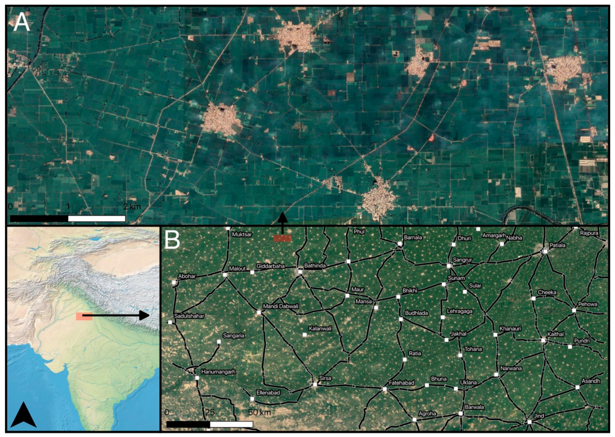
At a glance, the landscape the survey team encountered was flat and level, punctuated by tree-lines surrounding modern roads and villages situated on gentle rises. Occasional dunes rise gently in various areas, and their low summits are typically located far from canals or watercourses. These features are most often located in the least agriculturally developed parts of northwest India. In recent decades, the region has become progressively homogenous agriculturally, with a large portion of the land area consisting of low-lying farms divided into 1-acre-plots that produce irrigated crops (i.e., rice and wheat). The present landscape is characterized by four ongoing social processes: large-scale irrigation canal construction, maintenance and use; small-scale mechanized efforts to level the land to improve irrigation; growth of the villages that intersperse agricultural land; and the rapid expansion of developing towns and cities and their associated infrastructure (e.g., highways, power stations) (Figure 11). A rapidly developing landscape of towns and cities interconnected by major newly constructed interstate highways therefore cuts across this village landscape. The study area exhibits low levels of relief not just because of the floodplain character but also because of decades of agricultural production. This flattening process has been exacerbated by millennia of seasonal flooding, which have resulted in significant infilling [89,90].
Despite the homogenizing forces of agricultural and urban development, there is notable environmental variation within the study area [50,89]. The northern RGUs, including those around Jind and Tohana, and those immediately north of Sirsa (Figure 12), are irrigated by modern large-scale canals. The areas adjacent to those canals were particularly low-lying. From Agroha to Tohana, there has been less levelling for irrigation and a wider variety of environmental features were encountered, including extensive dunes with gentle slopes that rose from the southwest of the study area. Site preservation was still impacted by the construction of highways interlinking the cities of Tohana, Barwala, and Hisar. As the landscape becomes increasingly characterized by these dune features toward the southwest, the number of preserved cultural heritage sites decreases. A different set of survey techniques may thus be necessary to recover archaeological site locations in these areas.
A total of 199 historical map mound features were associated with an extant archaeological site in the present landscape (Table 1). There are clusters of sites around Sirsa, Tohana, and Jind. Each corresponds to a cluster of historical map mound features (Figure 12). The total number of features where archaeological sites were present (n = 199) equates to around 25% of the total tested historical map mound features. The majority (n = 169) of these site locations had not been reported by previous surveys, though many of the site locations reported prior to 2009 did not include specific or precise geographical coordinates, and it is possible that some of these sites had been visited by archaeologists in the past. Re-visitation of previously documented sites allowed the team to update reported coordinates and assess the current status of the site’s preservation. Still, there were numerous sites that fell within areas surveyed by previous projects that reported no sites, especially in the corridor from Tohana to Agroha. An additional 64 sites that do not appear to be associated with historical map mound features were also identified.
The survey area included only a small number of well-preserved mounds, as the majority of the region’s archaeological sites have undergone some degree of levelling to improve irrigation or earth mining for brick manufacture. Intact archaeological sites included the sprawling Medieval site of Uklanamandi (L329), and the well-preserved Early Historic mound near the village of Khasam in the same area (L279). The most common type of site encountered was an elevated mound that had been cut into terraces as landowners level square acre plots, producing multiple tiers [87]. Some sites had been completely removed, and were detectable only as occasional scatters of artifacts in irrigation ditches, or as a thin layer of artifacts in a section.
Size-2 form-line features most often corresponded to archaeological sites in the present landscape. Archaeological sites were identified at nearly 60% of the locations associated with this category of historical map mound features (Table 1). A complete table of tested locations is available in Table S1. Size-3 form-line features were also frequently archaeological sites (54%), as were features that combined form-lines with other elements (40%), though few of the latter fell within the sampled area (n = 5). Size-2 hachure features also often corresponded to archaeological sites in the present landscape (40%), but size-1 hachure features were rarely archaeological sites (8%). Overall shaded features were only rarely archaeological sites (13.64%) and indeed appear to most likely refer to sandy topographical features, such as dunes, which are themselves often undergoing removal (Figure 13).
While most size-1 features were not associated with extant archaeological sites, the number of size-1 form-line features that were was relatively high (n = 62, 26%). Overall, size-1 form-line features were twice as likely to be associated with extant archaeological sites than the shaded (13%) or hachure (8%) features in the same category. Together with the general observation that larger map features most often corresponded to extant archaeological sites in the present landscape, the strong association between form-line features and extant archaeological sites reveals that form-lines were the surveyors’ preferred symbol for depicting the kinds of topographical features that most often corresponded to archaeological sites in the areas assessed. When hachure features did correspond to features in the present landscape, they sometimes turned out to be mounds adjacent to ponds in modern villages, presumably related to pond excavation (Figure 14). Ponds corresponded to two poorly printed form-line features that did not turn out to be archaeological sites. Shaded features in all size categories often turned out to be sand dunes or natural topographic features. All features in the size-1 category—archaeological sites and sand dunes alike—appear more likely to have been removed as the landscapes of the region have been transformed over the last century.
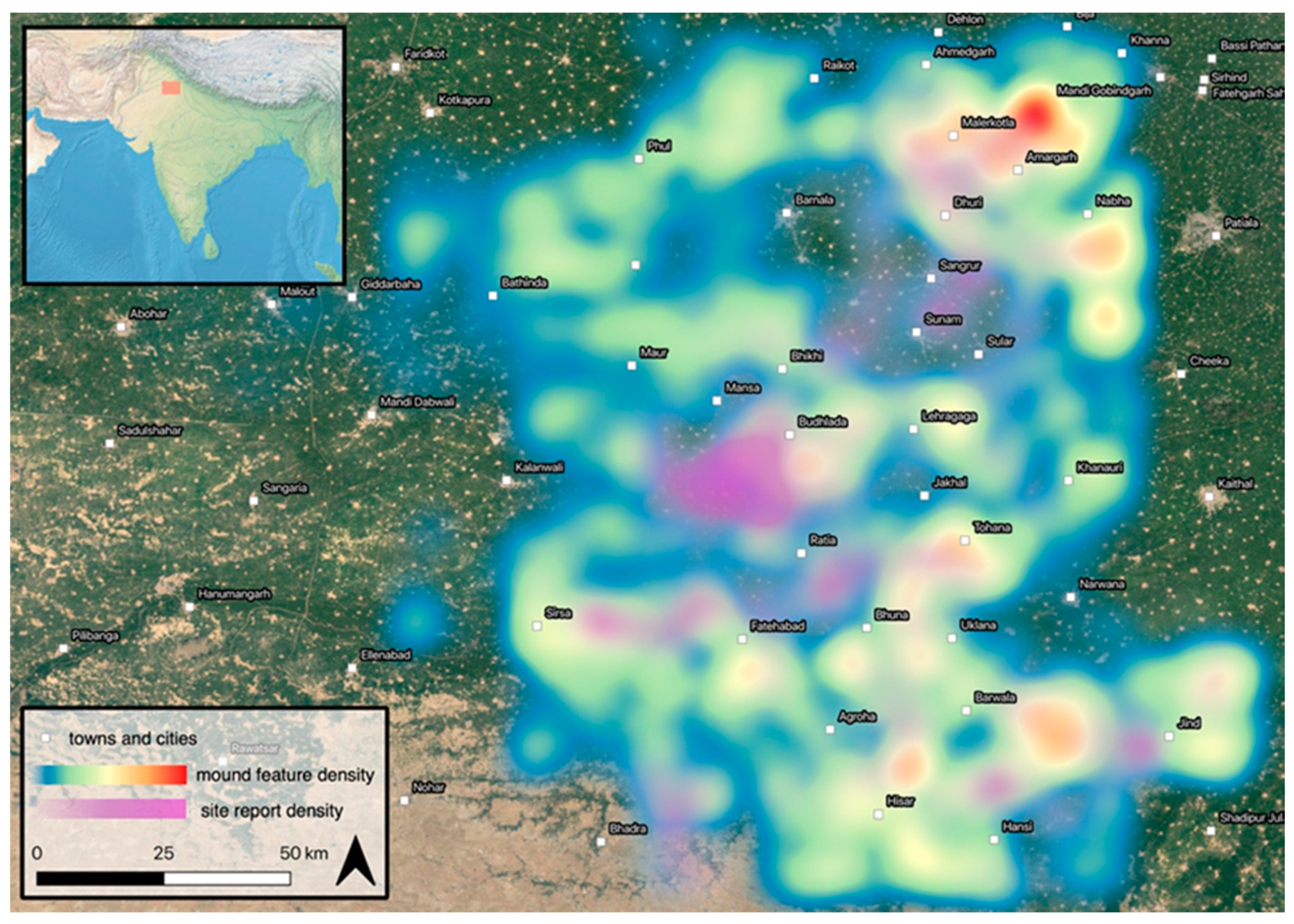
Given the relative strength and predictability of the relationships between particular kinds of historical map features and archaeological sites in the present landscape, it was possible to prepare a calibrated heat-map using QGIS that weights the raster interpolation using the probability that each historical map mound feature type corresponds to an archaeological site (Figure 15). The ‘weight points by’ function was used to assign each category a value associated with the probability its symbol and size category was an archaeological site. Form-line size-2 features were weighted 58.62, hachure size-2 features were weighted 40, and so forth (see Table 1 for probabilities). The resulting map predicts the location of additional sites across northwest India, including areas that have yet not been surveyed. The concentrations of historical map mound features in the southern half of the study area corresponded to known clusters of archaeological sites, strongly suggesting other hot spots also correspond to archaeological sites. These results indicate that there remain many archaeological sites to identify and preserve. There are also sizable voids surrounding many of these concentrations, suggesting either that some parts of the landscape lacked significant numbers of archaeological sites in the early twentieth century, or that the surveyors who carried out work on certain maps were less concerned with documenting mound features in those areas. It is thus worth considering the correlation between the patterns revealed by the historical maps and previously surveyed archaeological sites more closely.

4. Discussion

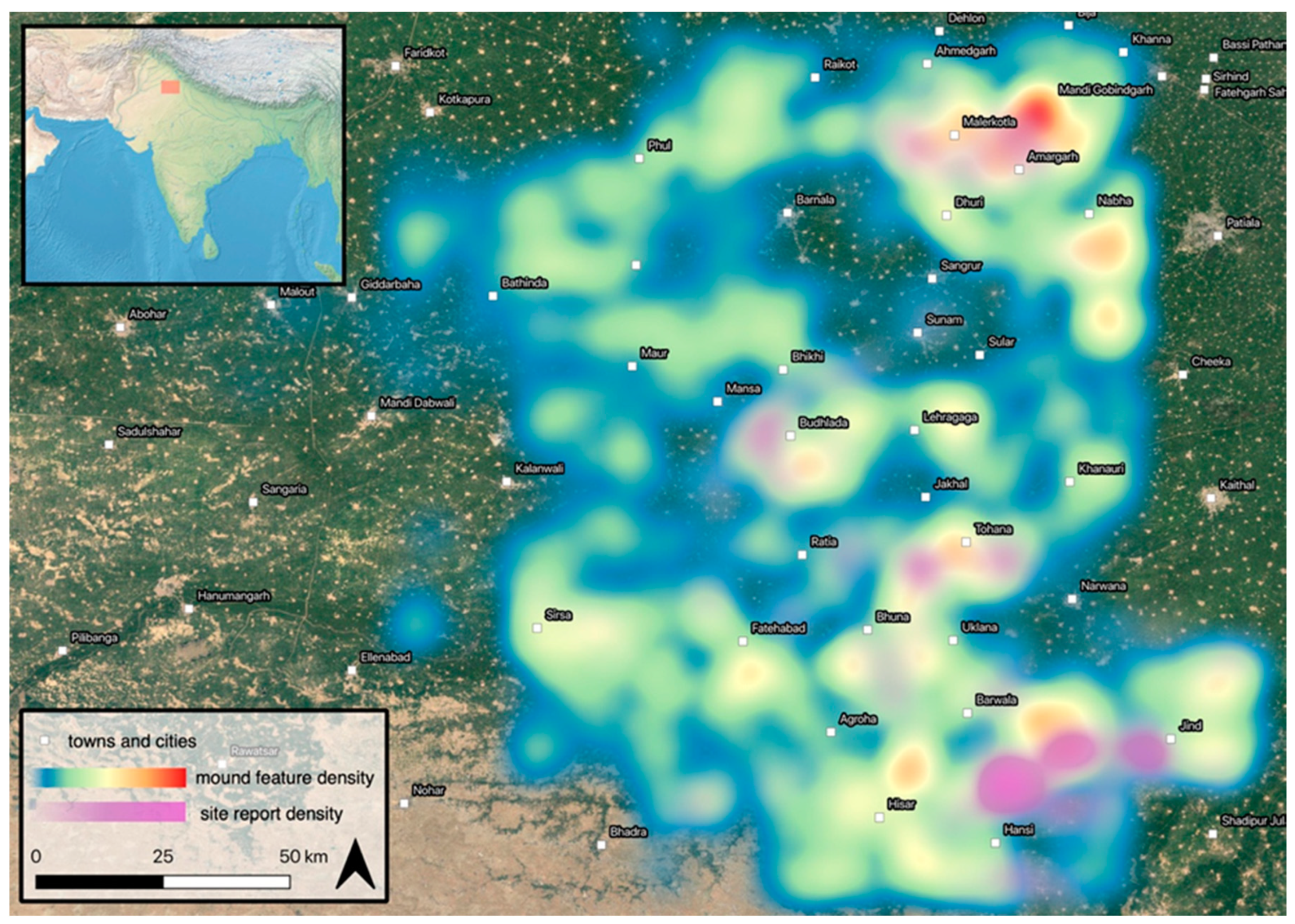
The Survey of India 1” to 1-mile maps contain considerable unrecognized information about northwest India’s past landscapes, suggesting that there are numerous areas filled with unreported archaeological sites. Moreover, comparing the locations of sites predicted by the weighted heat map with site distributions from other recent projects [82,83,84,86,91], offers some indication of how surveying historical map mound features from across the entire area covered by the historical maps may help researchers re-discover these ancient landscapes. There are clear discrepancies between concentrations of historical map features and concentrations of reported archaeological sites from different periods (Figure 16 and Figure 17), which imply the presence of a chronological sequence that links the present landscape with its historical and proto-historical antecedents.
Aside from a single concentration east of the city of Sirsa, the distribution of reported historical period sites does not align with concentrations of historical map mound features likely to be archaeological sites. Reported historical period sites are instead concentrated southwest of the town of Budhlada. Lighter concentrations appear near Sangrur and immediately southeast of Ratia, and there is an apparent void in high-probability historical map mound features surrounding the town Sunam, but there have been many historical sites reported in this area. The distribution of reported proto-historic sites—those associated with the Indus Civilization and the later ‘Painted Grey Ware’ period—is far more similar to the distribution of likely historical map mound features (Figure 17). Notable concentrations of proto-historical sites co-occur with the distribution of historical map mound features in the areas between Tohana and Bhuna, east of Ratia, and around Malerkotla. Another concentration of proto-historic sites is found in an area north of Hansi. Areas with large concentrations of predicted archaeological sites are therefore more likely associated with the proto-historical phases (the Indus Civilization and its post-urban phase) than with historical phases.
To test the robustness of this correlation, the regional grid for the ground truthing surveys was extended to encompass all areas were both site reports and historical mapping data are available. Three values were calculated for these hexagonal bins (Table S2). The first was a total number of predicted sites (A), which multiplies the total number of historical map mound features by a modifier determined by the probability that features of its symbol and size class were extant archaeological sites. The total number of proto-historic sites (B) and historic sites (C) aggregated from all survey data were also included in the counts ((A),(B),(C) in Figure 18). The number of predicted sites based on the historical features often exceeds what has been reported, which indicates that additional sites remain to be found. The Pearson’s correlation coefficient between A and B is 0.35, indicating a weak positive correlation between the number of predicted sites and the number of reported proto-historic sites. However, this correlation coefficient yields a p-value of 0.00000465, indicating its statistical significance at the 95% confidence interval. The correlation coefficient between A and C is, on the other hand, 0.1, indicating a much weaker relationship, and its p-value is 0.27—it is not statistically significant. This test supports the conclusion that predicted sites derived from the ground truthing results are more likely to be proto-historical than historical, indicating that they are more likely older and potentially related to landscapes of the Indus Civilization.
It would be presumptuous to take the potential phasing of any predicted site concentrations that have not been assessed in the field for granted, but this discussion highlights the potential of the historical maps to augment large-scale remote sensing studies and conduct targeted surveys of likely proto-historic landscapes. There are likely many Indus-associated settlements yet to be identified in several areas, such as the corridor running from Khanauri to Nabha and in the predicted hot spots surrounding the cities of Maur, Bathinda, and Phul. Visiting these concentrations will be particularly important for testing the easterly distribution of Indus-related settlements. The distribution of historical map mound features also thus provides the least information about the region’s more recent landscapes, such as those of the Medieval period. This is likely because the settlement distributions in these historical periods, especially during the Medieval period, are more closely associated with today’s settlement landscapes. The distribution of settlements in the Medieval period is the basis of the region’s modern village settlement system.
There remain many archaeological sites—proto-historic and historic—to locate and analyze in northwest India. This means, by extension, that current debates about landscape transformation in South Asia are built upon incomplete datasets. The predicted distribution of archaeological sites based on the ground truthing surveys can augment future studies, directing survey teams to areas where a large number of potential sites await documentation. They can also be compared to features identified using other techniques, such as remote-sensing, to bring more information about South Asia’s ancient landscapes into view.
Just as settlement patterns shifted prior to the emergence of today’s landscapes, so too has the environment of northwest India undergone considerable transformation across the millennia considered here. These variable environments made human settlement in this region more resilient to climate change [50]. Northwest India has an incredibly complex hydrology, which features thousands of kilometers of paleo-channels that have been active water courses at different points in the region’s past [92]. Moreover, there are several more localized environments, complete with a very wide range of water features and land types, that appear to have offered communities many subsistence opportunities in the past [67,89,93].
Undocumented concentrations of mound features should not be used as the sole data-source for organizing future surveys. There are some areas where the number of predicted sites is less than the number of reported sites. One such area is the void in the historical maps north of the city of Patiala, which is home to many reported Medieval period sites. These are also areas where archaeological sites have likely been removed as the landscape has developed over the past century. While the historical map mound feature type most likely to correspond to an archaeological site was the size-2 form-line feature, 48 (of 116) such features were not associated with an extant archaeological site. One area where archaeological mounds have likely been removed is nearby Sirsa. The land in this area has undergone intensive leveling, in part as a result of the flooding of the Ghaggar River. There are also concentrations of reported archaeological sites that are not found on the historical maps. This is unsurprising, as the maps vary in the degree to which they document mound features. Areas where there are discrepancies between predicted and reported sites should ultimately should be surveyed as comprehensively as possible using other techniques, including village-to-village survey, which has the potential to reveal archaeological sites that were not included on the historical map mound features. A goal for future research will be to ascertain why some of these sites were overlooked in the Survey of India mapping process. Ultimately, it will likely be necessary to conduct additional comprehensive and systematic surveys that interrogate the site concept, as there were certainly many ways of living in northwest India’s complex environments in the past.
The locations that were tested that did not turn out to be extant archaeological sites produced a valuable kind of data in and of themselves. While most of these locations today are nothing more than agricultural fields, some symbols turned out to be other types of landscape features—ponds, marshes and areas of positive relief. These features undoubtedly shaped human-environment interactions in the region and played an important role in its transformation over time. This varied landscape of marshes and dunes interspersed with fields contrasts with the present landscape of homogenized, levelled cultivated land that is farmed intensively to produce multiple crops per year. The historical maps can thus link the region’s intersecting signature landscapes into an overarching long-term trajectory. Future work that re-analyses the historical maps to identify these varied features would be extremely useful.

5. Conclusions

Historical map mound features from the Survey of India 1” to 1-mile maps offer a glimpse into a long and dynamic history of landscape change, connecting the multiple interlocking and interacting signature landscapes of South Asia to one another, and revealing how these dynamics have brought about today’s settlement landscapes. The present landscape itself is an outcome of social processes that were constrained by and built upon those that came before it and is thus an outcome of long-term processes that occurred over a very large area. Northwest India has been a major locus of human settlement for millennia and has been the site of a sequences of cultural landscapes. Archaeological survey coverage in the region is incomplete, and it is clear that many important cultural heritage sites remain unrecognized. Once georeferenced and searched for mound features, the Survey of India 1” to 1-mile map series constitutes an invaluable resource for understanding these past landscapes. This paper has presented the results of a survey that ground truthed these maps and found that around a quarter of all historical map mound features corresponded to archaeological sites in the present landscape, and that this correspondence varied by feature size and type. These type-wise proportions were used to create a weighted heatmap of the likelihood that mound features lying in areas outside of the ground truth survey could be archaeological sites, and this procedure has revealed that the mound features on the historical maps most often reflect pre- and proto-historic, rather than early historic and medieval landscapes. As the present landscape has undergone significant transformations, it is likely that many of the historical map mound features that did not correspond to an extant archaeological site may represent sites that have been destroyed, oftentimes quite recently. There should be no doubt that there remain many historical features to test in the field, and many unresolved questions about South Asia’s dynamic ancient landscapes to resolve.

Supplementary Materials

Available online at https://www.mdpi.com/2072-4292/11/18/2089/s1, Table S1: Tested Historical Map Mound Features, Table S2: Predicted Sites and Reported Sites in Each Hexagonal Bin.

Author Contributions

Conceptualization, A.S. Green, H.A. Orengo, and C.A. Petrie; method, A.S. Green, H.A. Orengo, and C.A. Petrie; validation, A.S. Green, H.A. Orengo, A. Garcia, F. Conesa, L.M. Green, A. Alam and A. Ranjan; formal analysis, A.S. Green; investigation, A.S. Green, L.M. Green, A. Alam and A. Ranjan.; resources, C.A. Petrie.; data curation, A.S. Green, H.A. Orengo.; writing—original draft preparation, A.S. Green.; writing—review and editing, A.S. Green, C.A. Petrie; visualization, A.S. Green; project administration, R.N. Singh, C.A. Petrie; funding acquisition, C.A. Petrie, R.N. Singh.

Funding

This research was carried out as part of the TwoRains project, which is funded by European Research Council under the European Union’s Horizon 2020 research and innovation program, grant agreement no. 648609. It builds upon the work of the Land, Water and Settlement project, which received support from DST/UKIERI, the British Academy and the McDonald Institute for Archaeological Research, and makes use of data collected by colleagues who have worked with us, beside us and before and after us in many areas. H.A. Orengo has contributed as a Ramón y Cajal Researcher (Spanish Ministry of Science, Innovation and Universities). A. Garcia-Molsosa’s contribution has been funded by the European Union’s Horizon 2020 Research and Innovation programme under the Marie Skłodowska-Curie grant agreement no. 746446 (WaMStrIn project). F.C. Consesa’s contribution has been funded by the European Union’s Horizon 2020 Research and Innovation programme under the Marie Skłodowska-Curie grant agreement no. 794711 (Marginscapes project).

Acknowledgments

This paper builds upon the work of the Land, Water and Settlement project, and makes use of data collected by colleagues who have worked with us, beside us and before and after us in many areas. Five anonymous peer reviewers provided comments on the original manuscript, which allowed the authors to make considerably improvements to the article. The TwoRains team would like to express especial thanks to Mr. Charanjit Singh Sandhu for driving the field team to at least 677 locations, 149 of which turned out to be archaeological sites.

Conflicts of Interest

The authors declare no conflict of interest.

References

  1. Wilkinson, T.J. Archaeological Landscapes of the Near East; University of Arizona Press: Tucson, AZ, USA, 2003. [Google Scholar]
  2. Lawrence, D.; Bradbury, J. Chronology, uncertainty and GIS: A methodology for characterising and understanding landscapes of the ancient Near East. eTopoi 2012, 3, 353. [Google Scholar]
  3. Lawrence, D.; Philip, G.; Wilkinson, K.; Buylaert, J.P.; Murray, A.S.; Thompson, W.; Wilkinson, T.J. Regional power and local ecologies: Accumulated population trends and human impacts in the northern Fertile Crescent. Quat. Int. 2015, 437, 1–22. [Google Scholar] [CrossRef]
  4. Green, A.S.; Petrie, C.A. Landscapes of Urbanization and De-Urbanization: A Large-Scale Approach to Investigating the Indus Civilization’s Settlement Distributions in Northwest India. J. Field Archaeol. 2018, 43, 284–299. [Google Scholar] [CrossRef]
  5. Petrie, C.A.; Orengo, H.; Green, A.; Walker, J.; Garcia, A.; Conesa, F.; Knox, J.; Singh, R.N. Mapping Archaeology While Mapping an Empire: Using Historical Maps to Reconstruct Ancient Settlement Landscapes in Modern India and Pakistan. Geosciences 2019, 9, 11. [Google Scholar] [CrossRef]
  6. Kenoyer, J.M. Early City-States in South Asia: Comparing the Harappan Phase and the Early Historic Period. In The Archaeology of City-States: Cross-Cultural Approaches; Nichols, D.L., Charlton, T.H., Eds.; Smithsonian Series in Archaeological Inquiry; Smithsonian Institution Press: Washington, DC, USA, 1997; pp. 51–70. [Google Scholar]
  7. Possehl, G.L. The Indus Civilization: A Contemporary Perspective; AltaMira Press: Walnut Creek, CA, USA, 2002. [Google Scholar]
  8. Chakrabarti, D.K. India: An Archaeological History: Palaeolithic Beginnings to Early Historic Foundations, 2nd ed.; Oxford University Press: New Delhi, India, 2009. [Google Scholar]
  9. Wright, R.P. The Ancient Indus: Urbanism, Economy and Society; Cambridge University Press: Cambridge, UK, 2010. [Google Scholar]
  10. Ratnagar, S.F. Harappan Archaeology: Early State Perspectives; Primus Books: Delhi, Indian, 2016. [Google Scholar]
  11. Shinde, V.S. Current Perspectives on the Harappan Civilization. In A Companion to South Asia in the Past; Schug, G.R., Walimbe, S.R., Eds.; John Wiley & Sons: Hoboken, NJ, USA, 2016; pp. 127–144. [Google Scholar]
  12. Petrie, C.A.; Singh, R.N. Investigating Cultural and Geographical Transformations from the Collapse of Harappan Urbanism to the Rise of the Great Early Historic Cities: A Note on the Land, Water, and Settlement Project. South Asian Stud. 2008, 24, 37–38. [Google Scholar]
  13. Singh, R.N.; Petrie, C.A.; French, C.A.; Goudie, A.S.; Gupta, S.; Tewari, R.; Singh, A.K.; Sinha, R.; Srivastava, R.; Yadav, S. Settlements in context: Reconnaissance in Western Uttar Pradesh and Haryana. Man Environ. 2008, 33, 71–87. [Google Scholar]
  14. Singh, R.N.; Singh, M.; Petrie, C.A. Addressing problems of context: The Rakhigarhi Hinterland Survey-2009. Manaviki 2010, 1, 24–28. [Google Scholar]
  15. Casana, J. Alalakh and the Archaeological Landscape of Mukish: The Political Geography and Population of a Late Bronze Age Kingdom. Bull. Am. Sch. Orient. Res. 2009, 353, 7–37. [Google Scholar] [CrossRef]
  16. Chase, A.F.; Chase, D.Z.; Weishampel, J.F.; Drake, J.B.; Shrestha, R.L.; Slatton, K.C.; Awe, J.J.; Carter, W.E. Airborne LiDAR, archaeology, and the ancient Maya landscape at Caracol, Belize. J. Archaeol. Sci. 2011, 38, 387–398. [Google Scholar] [CrossRef]
  17. Ur, J.; de Jong, L.; Giraud, J.; Osborne, J.F.; MacGinnis, J. Ancient Cities and Landscapes in the Kurdistan Region of Iraq: The Erbil Plain Archaeological Survey 2012 Season. Iraq 2013, 75, 89–117. [Google Scholar] [CrossRef] [Green Version]
  18. Tapete, D. Remote Sensing and Geosciences for Archaeology. Geosciences 2018, 8, 41. [Google Scholar] [CrossRef]
  19. Garcia, A.; Orengo, H.; Conesa, F.; Green, A.; Petrie, C.A. Remote Sensing and Historical Morphodynamics of Alluvial Plains. The 1909 Indus Flood and the City of Dera Gazhi Khan (Province of Punjab, Pakistan). Geosciences 2019, 9, 21. [Google Scholar] [CrossRef]
  20. Joshi, J.P.; Madhu, B.; Jassu, R. The Indus Civilization: A reconsideration on the basis of distribution maps. In Frontiers of the Indus Civilization, Sir Mortimer Wheeler Commemoration Volume; Lal, B.B., Gupta, P., Eds.; Books & Books: New Delhi, India, 1984. [Google Scholar]
  21. Possehl, G.L. Indus Age: The Beginnings; University of Pennsylvania Press: Philadelphia, PA, USA, 1999. [Google Scholar]
  22. Chakrabarti, D.K.; Saini, S. The Problem of the Sarasvati River and Notes on the Archaeological Geography of Haryana and Indian Panjab; Aryan Books International: New Delhi, India, 2009. [Google Scholar]
  23. Kumar, M. Harappan Settlements in the Ghaggar-Yamuna Divide. In Occasional Paper 7: Linguistics, Archaeology and the Human Past; Osada, T., Uesugi, A., Eds.; Research Institute for Humanity and Nature: Kyoto, Japan, 2009; pp. 1–24. [Google Scholar]
  24. Rondelli, B.; Stride, S.; García-Granero, J.J. Soviet military maps and archaeological survey in the Samarkand region. J. Cult. Herit. 2013, 14, 270–276. [Google Scholar] [CrossRef]
  25. Balbo, A.L.; Rondelli, B.; Cecília Conesa, F.; Lancelotti, C.; Madella, M.; Ajithprasad, P. Contributions of geoarchaeology and remote sensing to the study of Holocene hunter–gatherer and agro-pastoral groups in arid margins: The case of North Gujarat (Northwest India). Quat. Int. 2013, 308, 53–65. [Google Scholar] [CrossRef]
  26. Conesa, F.C.; Madella, M.; Galiatsatos, N.; Balbo, A.L.; Rajesh, S.V.; Ajithprasad, P. CORONA Photographs in Monsoonal Semi-arid Environments: Addressing Archaeological Surveys and Historic Landscape Dynamics over North Gujarat, India: CORONA Photographs in Monsoonal Semi-arid North Gujarat, India. Archaeol. Prospect. 2015, 22, 75–90. [Google Scholar] [CrossRef]
  27. Wheatley, D.; Gillings, M. Spatial Technology and Archaeology: The Archaeological Applications of GIS; Taylor & Francis: New York, NY, USA, 2002. [Google Scholar]
  28. Kintigh, K. The Promise and Challenge of Archaeological Data Integration. Am. Antiq. 2006, 71, 567. [Google Scholar] [CrossRef]
  29. Conolly, J.; Lake, M. Geographical Information Systems in Archaeology; Cambridge Manuals in Archaeology; Cambridge University Press: Cambridge, UK, 2006. [Google Scholar]
  30. Snow, D.R. Making Legacy Literature and Data Accessible in Archaeology. In Making History Interactive. Com-Puter Applications and Quantitative Methods in Archaeology; Frischer, B., Crawford, J., Koller, D., Eds.; BAR International Series S2079; Archaoepress: Oxford, UK, 2010; pp. 350–355. [Google Scholar]
  31. Cooper, A.; Green, C. Embracing the Complexities of ‘Big Data’ in Archaeology: The Case of the English Landscape and Identities Project. J. Archaeol. Method Theory 2015, 23, 271–304. [Google Scholar] [CrossRef]
  32. Green, A.S. Mohenjo-Daro’s Small Public Structures: Heterarchy, Collective Action and a Re-visitation of Old Interpretations with GIS and 3D Modelling. Camb. Archaeol. J. 2018, 28, 205–223. [Google Scholar] [CrossRef]
  33. Smith, S.; Chambrade, M.-L. The Application of Freely-Available Satellite Imagery for Informing and Complementing Archaeological Fieldwork in the “Black Desert” of North-Eastern Jordan. Geosciences 2018, 8, 491. [Google Scholar] [CrossRef]
  34. Luo, L.; Wang, X.; Guo, H.; Lasaponara, R.; Shi, P.; Bachagha, N.; Li, L.; Yao, Y.; Masini, N.; Chen, F.; et al. Google Earth as a Powerful Tool for Archaeological and Cultural Heritage Applications: A Review. Remote Sens. 2018, 10, 1558. [Google Scholar] [CrossRef]
  35. Elfadaly, A.; Lasaponara, R. On the Use of Satellite Imagery and GIS Tools to Detect and Characterize the Urbanization around Heritage Sites: The Case Studies of the Catacombs of Mustafa Kamel in Alexandria, Egypt and the Aragonese Castle in Baia, Italy. Sustainability 2019, 11, 2110. [Google Scholar] [CrossRef]
  36. Verhoeven, G.J.J. Providing an archaeological bird’s-eye view—An overall picture of ground-based means to execute low-altitude aerial photography (LAAP) in Archaeology. Archaeol. Prospect. 2009, 16, 233–249. [Google Scholar] [CrossRef]
  37. Verhoeven, G.; Sevara, C.; Karel, W.; Ressl, C.; Doneus, M.; Briese, C. Undistorting the past: New techniques for orthorectification of archaeological aerial frame imagery. In Good Practice in Archaeological Diagnostics: Non-Invasive Survey of Complex Archaeological Sites; Corsi, C., Slapšak, B., Vermeulen, F., Eds.; Natural Science in Archaeology; Springer: Berlin/Heidelberg, Germany, 2013. [Google Scholar]
  38. Parcak, S.H. Remote Sensing in Archaeology; Wiseman, J., El-Baz, F., Eds.; Interdisciplinary Contributions to Archaeology; Springer: Berlin/Heidelberg, Germany, 2007. [Google Scholar]
  39. Masini, N.; Gizzi, F.; Biscione, M.; Fundone, V.; Sedile, M.; Sileo, M.; Pecci, A.; Lacovara, B.; Lasaponara, R. Medieval Archaeology under the Canopy with LiDAR. The (Re) Discovery of a Medieval Fortified Settlement in Southern Italy. Remote Sens. 2018, 10, 1598. [Google Scholar] [CrossRef]
  40. Magli, G. The Sacred Landscape of the “Pyramids” of the Han Emperors: A Cognitive Approach to Sustainability. Sustainability 2019, 11, 789. [Google Scholar] [CrossRef]
  41. Petrie, C.A. Remote sensing in inaccessible lands: Plains and preservation along old routes between Pakistan and Afghanistan. ArchAtlas 2007, 3. [Google Scholar] [CrossRef]
  42. Casana, J.; Laugier, E.J. Satellite imagery-based monitoring of archaeological site damage in the Syrian civil war. PLoS ONE 2017, 12, e0188589. [Google Scholar] [CrossRef] [PubMed]
  43. Orengo, H.A.; Krahtopoulou, A.; Garcia-Molsosa, A.; Palaiochoritis, K.; Stamati, A. Photogrammetric re-discovery of the hidden long-term landscapes of western Thessaly, central Greece. J. Archaeol. Sci. 2015, 64, 100–109. [Google Scholar] [CrossRef]
  44. Hammer, E.; Seifried, R.; Franklin, K.; Lauricella, A. Remote assessments of the archaeological heritage situation in Afghanistan. J. Cult. Herit. 2018, 33, 125–144. [Google Scholar] [CrossRef] [Green Version]
  45. Hammer, E.; Ur, J. Near Eastern Landscapes and Declassified U2 Aerial Imagery. Adv. Archaeol. Pract. 2019, 7, 1–20. [Google Scholar] [CrossRef]
  46. Wright, R.; Hritz, C. Satellite Remote Sensing Imagery: New Evidence for Sites and Ecologies in the Upper Indus. In South Asian Archaeology 2007; BAR International Series: Oxford, UK, 2013; pp. 315–321. [Google Scholar]
  47. Prabhakar, V.N.; Korisettar, R. Ground Survey to Aerial Survey:Methods and Best Practices in Systematic Archaeological Explorations and Excavations. Curr. Sci. 2017, 113, 1873. [Google Scholar] [CrossRef]
  48. Petrie, C.A.; Lynam, F. Revisiting settlement contemporaneity and exploring stability and instability: Case-studies from the Indus Civilisation, Journal of Field Archaeology 45.1. J. Field Archaeol. 2019, 45. [Google Scholar] [CrossRef]
  49. Orengo, H.A.; Conesa, F.C.; Garcia, A.; Green, A.S.; Petrie, C.A. Living on the edge of the desert: Automated detection of archaeological mounds in Cholistan (Pakistan) using machine learning classification of multi-sensor and multi-temporal satellite data 2019. In Preparation.
  50. Petrie, C.A.; Singh, R.N.; Bates, J.; Dixit, Y.; French, C.A.I.; Hodell, D.A.; Jones, P.J.; Lancelotti, C.; Lynam, F.; Neogi, S.; et al. Adaptation to Variable Environments, Resilience to Climate Change: Investigating Land, Water and Settlement in Indus Northwest India. Curr. Anthropol. 2017, 58, 1–30. [Google Scholar] [CrossRef]
  51. Petrie, C.A. South Asia. In The Oxford Handbook of Cities in World History; Oxford University Press: Oxford, UK, 2013; pp. 83–104. [Google Scholar]
  52. Sinopoli, C.M. Ancient South Asian cities in their regions. In The Cambridge World History; Yoffee, N., Ed.; Cambridge University Press: Cambridge, UK, 2015; pp. 319–342. [Google Scholar]
  53. Wright, R.P. Comparative Perspectives and Early States Revisited. In State Formations; Brooke, J.L., Strauss, J.C., Anderson, G., Eds.; Cambridge University Press: Cambridge, UK, 2018. [Google Scholar]
  54. Wright, R.P.; Schuldenrein, J.; Khan, M.A.; Mughal, M. The emergence of satellite communities along the Beas drainage: Preliminary results from Lahoma Lal Tibba and Chak Purbane Syal. South Asian Archaeol. 2001, 1, 327–336. [Google Scholar]
  55. Wright, R.P.; Schuldenrein, J.; Khan, M.A.; Malin-Boyce, S. The Beas River Landscape and Settlement Survey: Preliminary Results from the Site of Vainiwal. In South Asian Archaeology 2003; Franke-Vogt, U., Weisshar, H.J., Eds.; Linden Soft: Aachen, Germany, 2003. [Google Scholar]
  56. Parikh, D.; Petrie, C.A. ‘We are inheritors of a rural civilisation’: Rural complexity and the ceramic economy in the Indus Civilisation in northwest India. World Archaeol. 2018. [Google Scholar] [CrossRef]
  57. Singh, R.N.; Petrie, C.A.; Pawar, V.; Pandey, A.K.; Parikh, D. New Insights into Settlement along the Ghaggar and its Hinterland: A Preliminary Report on the Ghaggar Hinterland Survey 2010. Man Environ. 2011, 36, 89–106. [Google Scholar]
  58. Singh, R.N.; Green, A.S.; Ranjan, A.; Green, L.M.; Alam, A.; Petrie, C.A. Between the Hinterlands: Preliminary Results from the TwoRains Survey in Northwest India 2017. Man Environ. 2018, 43, 84–102. [Google Scholar]
  59. Singh, U. Delhi: Ancient History; Readings in History; Social Science Press: New Delhi, India, 2006. [Google Scholar]
  60. Singh, U. A History of Ancient and Early Medieval India: From the Stone Age to the 12th Century; Pearson Education: New Delhi, India, 2008. [Google Scholar]
  61. Phadke, H.A. Haryana, Ancient and Medieval; Harman Pub. House: New Delhi, India, 1990. [Google Scholar]
  62. Flam, L. The Paleogeography and Prehistoric Settlement Patterns in Sind, Pakistan (CA. 4000-2000 B.C.). Ph.D. Thesis, University of Pennsylvania, Philadelphia, PA, USA, 1981. [Google Scholar]
  63. Mughal, M.R. Ancient Cholistan: Archaeology and Architecture; Ferozsons: Lahore, Pakistan, 1997. [Google Scholar]
  64. Singh, R.N.; Petrie, C.A.; Pawar, V.; Pandey, A.K.; Neogi, S.; Singh, M.; Singh, A.K.; Parikh, D.; Lancelotti, C. Changing patterns of settlement in the rise and fall of Harappan urbanism and beyond: A preliminary report on the Rakhigarhi Hinterland Survey 2009. Man Environ. 2010, 37, 37–53. [Google Scholar]
  65. Teramura, H.; Uno, T. Spatial Analyses of Harappan Urban Settlements. Anc. Asia 2006, 1, 73. [Google Scholar] [CrossRef] [Green Version]
  66. Giosan, L.; Clift, P.D.; Macklin, M.G.; Fuller, D.Q.; Constantinescu, S.; Durcan, J.A.; Stevens, T.; Duller, G.A.; Tabrez, A.R.; Gangal, K. Fluvial landscapes of the Harappan civilization. Proc. Natl. Acad. Sci. USA 2012, 109, E1688–E1694. [Google Scholar] [CrossRef]
  67. Green, A.S.; Bates, J.; Acabado, S.; Coutros, P.R.; Glover, J.B.; Miller, N.F.; Rissolo, D.; Sharratt, N.; Petrie, C.A. How to last a millennium: A global perspective on the long-term social dynamics of resilience and sustainability. PLoS ONE. in preparation.
  68. Bhan, S. Excavations at Mitathal (Hissar) 1968. J. Haryana Stud. 1969, 1, 1–15. [Google Scholar]
  69. Bhan, S. Excavation at Mitathal (1968) and Other Explorations; Kurukshetra University: Haryana, India, 1975. [Google Scholar]
  70. Singh, A. Archaeology of Karnal and Jind Districts [Haryana]. Ph. D. Thesis, Kurukshetra University, Haryana, India, 1981. [Google Scholar]
  71. Dangi, V. Indus (Harappan) civilization in the Ghaggar Basin. In Current Research on Indus Archaeology; Uesugi, A., Ed.; South Asian Archaeology; Research Group for South Asian Archaeology, Archaeological Research Institute, Kansai University: Osaka, Japan, 2018. [Google Scholar]
  72. Bisht, R.S. Further Excavations at Banawali: 1983–1984. In Archaeology and History: Essays in Memory of Shri A. Ghosh; Pande, B., Chattopadhyaya, B., Ghosh, A., Eds.; Agam Kala Prakashan: Delhi, India, 1987; pp. 135–156. [Google Scholar]
  73. Khatri, J.S.; Acharya, M. Kunal: A New Indus-Saraswati Site. Puratattva 1995, 25, 84–86. [Google Scholar]
  74. Nath, A. Rakhigarhi: A Harappan Metropolis in the Sarasvati-Drishadvati Divide. Puratattva 1998, 28, 39–45. [Google Scholar]
  75. Nath, A. Further Excavations at Rakhigarhi. Puratattva 1999, 29, 46–49. [Google Scholar]
  76. Lal, B.B. Excavations at Kalibangan, the Early Harappans, 1960–1969; Archaeological Survey of India: New Delhi, India, 2003. [Google Scholar]
  77. Nath, A. Rakhigarhi: 1999–2000. Puratattva 2001, 31, 43–45. [Google Scholar]
  78. Shinde, V.S.; Osada, T.; Sharma, M.M.; Uesugi, A.; Uno, T.; Maemoku, H.; Shirvalkar, P.; Deshpande, S.S.; Kulkarni, A.; Sarkar, A.; et al. Exploration in the Ghaggar Basin and excavations at Girawad, Farmana (Rohtak District) and Mitathal (Bhiwani District), Haryana, India. In Occasional Paper 3: Linguistics, Archaeology and the Human Past; Osada, T., Uesugi, A., Eds.; Indus Project, Research Institute for Humanity and Nature 2008: Kyoto, Japan, 2008. [Google Scholar]
  79. Shinde, V.S.; Green, A.S.; Parmar, N.; Sable, P.D. Rakhigarhi and the Harappan Civilization: Recent Work and New Challenges. Bull. Deccan Coll. Res. Inst. 2012, 72, 43–53. [Google Scholar]
  80. Lal, B.B.; Joshi, J.P.; Madhu Bala, A.K.S.; Ramachandran, K.S. Excavations at Kalibangan: The Harappans (1960–1969): Part-1; Archaeological Survey of India: New Delhi, India, 2015. [Google Scholar]
  81. Osada, T. Environmental change and the Indus civilization: Main outcome of RIHN’s project (2007–2011). Quat. Int. 2012, 279–280, 362. [Google Scholar] [CrossRef]
  82. Dangi, V.; Osada, T.; Dangi, V. Archaeology of the Ghaggar Basin: Settlement Archaeology of Meham Block, Rohtak, Haryana, India; Linguistics, Archaeology and the Human Past; Research Inst. for Humanity and Nature: Kyoto, Japan, 2009. [Google Scholar]
  83. Parmar, N. Protohistoric Investigations in the Bhiwani District of Haryana; Deccan College Post Graduate and Research Institute: Pune, India, 2012. [Google Scholar]
  84. Pawar, V. Archaeological Settlement Pattern of Hanumangarh District (Rajasthan); Maharshi Dayanand University: Rohtak, India, 2012. [Google Scholar]
  85. Sharan, A.; Pawar, V.; Parmar, N. An Archaeological Reconnaissance of the Proto-historic Settlements in Mansa District, Punjab. Herit. J. Multidiscip. Stud. Archaeol. 2013, 1, 500–514. [Google Scholar]
  86. Sharan, A. Archaeological Settlement Pattern of Sangrur and Mansa Districts (Punjab); Maharshi Dayanand University: Rohtak, India, 2018. [Google Scholar]
  87. Singh, R.N.; Green, A.S.; Alam, A.; Petrie, C.A. Beyond the Hinterlands: Preliminary Results from the TwoRains Survey in Northwest India 2018. Man Environ. in press.
  88. Kantner, J. The Archaeology of Regions: From Discrete Analytical Toolkit to Ubiquitous Spatial Perspective. J. Archaeol. Res. 2008, 16, 37–81. [Google Scholar] [CrossRef]
  89. Neogi, S. Geoarchaeological Investigations of Indus Settlements in the Plains of North Western India. Ph.D. Thesis, University of Cambridge, Cambridge, UK, 2013. [Google Scholar]
  90. Neogi, S.; French, C.A.I.; Durcan, J.A.; Singh, R.N.; Petrie, C.A. Geoarchaeological insights into the location of Indus settlements on the plains of northwest India 2019. In Preparation.
  91. Dangi, V. A Study of Proto-Historic Settlements in Upper Ghaggar Basin; Maharshi Dayanand University: Rohtak, India, 2010. [Google Scholar]
  92. Orengo, H.A.; Petrie, C.A. Large-scale, multi-temporal remote sensing of palaeo-river networks: A case study from northwest India and its implications for the Indus Civilisation. Remote Sens. 2017, 9, 735. [Google Scholar] [CrossRef]
  93. Walker, J. Geomorphological studies surrounding the settlements of Lohari Ragho I and Masudpur 2019. In Preparation.
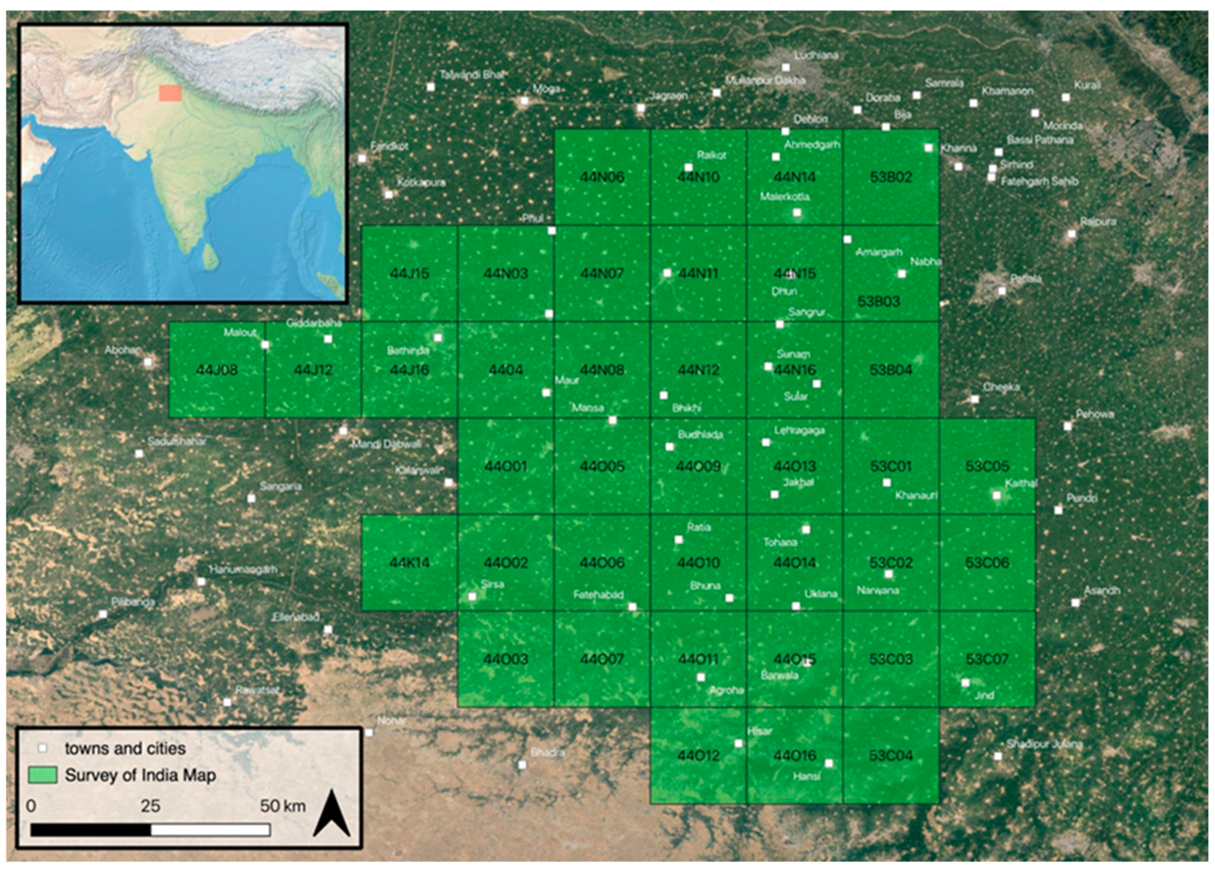
Figure 1. Location of study area and map numbers that have been georeferenced (adapted from [5]); Basemap: Google Earth Satellite Imagery (2019); Town names from Open Street Map (2019) Coordinate Reference System: World Geodetic System 1984.
Remotesensing 11 02089 g001
Figure 2. View from an elevated mound feature in northwest India (L742).
Remotesensing 11 02089 g002
Figure 3. Ancient Agroha on Survey of India maps (left) and 2019 Google Earth Imagery (right).
Remotesensing 11 02089 g003
Figure 4. Elevated feature types on Survey of India maps. From right to left: shaded, hachure and form line (adapted from [5]).
Remotesensing 11 02089 g004
Figure 5. Historical map mound feature locations and recently surveyed areas; Basemap: Google Earth Satellite Imagery (2019); Coordinate Reference System: World Geodetic System 1984.
Remotesensing 11 02089 g005
Figure 6. Present study in the context of an integrated historical mapping/remote sensing workflow.
Remotesensing 11 02089 g006
Figure 7. Location of ground truthing surveys. Basemap: Google Earth Satellite Imagery (2019); Coordinate Reference System: World Geodetic System 1984.
Remotesensing 11 02089 g007
Figure 8. Regional grid unit and locations of interest for field assessment. Basemap: Google Maps (2019); Coordinate Reference System: World Geodetic System 1984.
Remotesensing 11 02089 g008
Figure 9. Irrigation pump-house of the type often associated with exposed artifacts.
Remotesensing 11 02089 g009
Figure 10. Site recording procedure.
Remotesensing 11 02089 g010
Figure 11. Modern signature landscapes. (A) Villages and local roads, (B) rapidly developing highway infrastructure and towns. Towns and highway infrastructure derived from Open Street Map (2019); Basemap: Google Earth Satellite Imagery (2019); Coordinate Reference System: World Geodetic System 1984.
Remotesensing 11 02089 g011
Figure 12. Site presence/absence at ground truthed historical features. Basemap: Google Earth Satellite Imagery (2019); Coordinate Reference System: World Geodetic System 1984.
Remotesensing 11 02089 g012
Figure 13. Dune surface encountered during the survey.
Remotesensing 11 02089 g013
Figure 14. Many hachure features were extant ponds, as seen here.
Remotesensing 11 02089 g014
Figure 15. Weighted heat map of elevated mound features from the historical maps. Each feature was assigned a weight based on the proportion of ground truthed features that were extant archaeological sites (see Table 1). Basemap: Google Earth Satellite Imagery (2019); Coordinate Reference System: WSG 1984.
Remotesensing 11 02089 g015
Figure 16. Distribution of reported historical period (Early Historic and Medieval) sites based on recent surveys (reported sites) projected over weighted heatmap of historical mapping features (predicted sites). Town and cities derived from Open Street Map (2019); Basemap: Google Earth Satellite Imagery (2019); Coordinate Reference System: World Geodetic System 1984.
Remotesensing 11 02089 g016
Figure 17. Distribution of reported proto-historical sites based on recent surveys (reported sites) projected over weighted heatmap of historical mapping features (predicted sites). Town and cities derived from Open Street Map (2019); Basemap: Google Earth Satellite Imagery (2019); Coordinate Reference System: World Geodetic System 1984.
Remotesensing 11 02089 g017
Figure 18. Extended grid based on the RGU sample grid. Each hexagon contains three values (A, B, C): its predicted number of sites (A), reported number of proto-historical sites (B), and reported number of historical sites (C) in each hexagonal grid unit that have been both mapped and surveyed (SI 2). Basemap: Google Earth Satellite Imagery (2019); Coordinate Reference System: World Geodetic System 1984.
Remotesensing 11 02089 g018
Table 1. Site presence/absence at ground truthed historical features, and proportions of tested features in each category with extant archaeological sites.
Feature TypeTotal
Positive % (n)
Size 3
Positive % (n)
Size 2
Positive % (n)
Size 1
Positive % (n)
combined40 (5)50 (2)33.33 (3)0 (0)
form line38.17 (393)54.05 (37)58.62 (116)25.83 (240)
shaded13.64 (154)5.56 (18)15.79 (76)13.33 (60)
hachure11.45 (227)0 (1)40 (25)7.96 (201)
totals by size 37.93 (58)41.36 (220)17.17 (501)