1. Introduction
As the main body of the land ecosystem, global forests annually absorb 2.4 Pg C from the atmosphere [
1]. Approximately 10%–20% of atmospheric CO
2 emissions that are attributed to land-use change, especially deforestation and forest degradation, forest ecosystem carbon sequestration capacity and changes exert a considerable effect on the conversion of carbon source and sink functions of terrestrial ecosystems [
2,
3]. In May 2018, the global average monthly concentration of CO
2 reached 410.26 mg/L [
4]. With the continuous increase in atmospheric CO
2 concentration against the background of global warming, the accurate estimation of forest ecosystem carbon and its characteristics is related to whether the atmospheric CO
2 concentration can be reduced and the global warming trend can be curbed [
5,
6]. Thus, the forest carbon estimation has become a focus in the study of terrestrial carbon cycles [
1,
7].
Changes in the forest and atmospheric carbon cycles have become a global problem [
4,
8]. A quantitative study of the carbon reserves of forest ecosystems should start on a large regional scale [
8]. The traditional methods based on site observation or statistical data requires considerable amounts of manpower, material resources, and financial resources, and yet the results still lack timeliness because of the long period of large-scale data acquisition. More importantly, the reliability of statistical data and the representativeness of observation data from point to surface are questionable. By contrast, remote sensing methods are stable, continuous, real-time, low cost, and large scale, and can well reflect the regional-scale distribution characteristics of the forest ecosystem carbon and improve the accuracy of estimating forest ecosystem CO
2 sources and sinks; thus, remote sensing has become an important tool for carbon storage estimation [
9,
10]. Estimating the carbon storage in a large area is nearly impossible when using high-resolution images, because of the exorbitant cost. However, low-resolution images yield rough results; thus, the use of medium-resolution remote sensing images is a good choice in a large study area [
9,
10].
Over the past 20 years, many scholars have studied forest carbon and made important achievements; however, their studies have mainly focused on the national scale, and systematic studies on forest carbon on the province scale are still few [
11,
12]. Forest carbon storage remarkably varies across provinces because of the vast territory, large regional spatial differences, complex natural environment, and diverse forest ecosystem [
13]. Furthermore, forest carbon storage is affected by scale, and the values of provincial carbon storage vary across different research scales. China has a vast territory, large regional spatial differences, complex natural environments, and diverse forest resources. In China, the value for one province, such as Hubei Province in the south, obtained on the national scale is considerably lower than that obtained on the provincial scale [
14,
15]. Moreover, a province is an important administrative unit for the implementation of carbon emission and forest management measures. Therefore, the carbon reserves and their characteristics should be further studied on the provincial scale.
Forest ecosystems not only have the spatial rule in the horizontal direction but also have the stratification rule in the vertical direction [
16]. A forest ecosystem is generally divided into the arbor, shrub, herb, litter, and soil layers in the vertical direction [
5]. With the differences in the environment, the ecological activities and ecological processes in forest ecosystems greatly differ [
5,
17], resulting in biomass and carbon storage differences and stratification. Vertical forest stratification is the adaptation process of the vegetation to the environmental heterogeneity of the community and is also one of the basic characteristics of the plant community. However, existing studies on the carbon storage in forest ecosystems mainly focus on a certain layer, especially the tree canopy layer and soil layer. Specialized studies on the carbon storage in various forest layers in the vertical direction are still rare. Furthermore, previous related studies have been based on points, such as sites or samples, rather than on continuous surfaces. Site-specific results cannot be generalized to large-scale regions. Therefore, the following issues require definitive answers: the rule governing carbon storage in the vertical direction on continuous surfaces; the contribution of each layer to carbon storage in forest ecosystems; the contribution of one layer of different forest types to the carbon reserves of forest ecosystems; and the differences among the contributions of different layers. Therefore, the distribution and contribution of forest ecosystem carbon reserves in the vertical stratification structure should be further studied.
The majority of related studies have focused on carbon storage in temperate and tropical forests in the north, whereas few have investigated the carbon density of subtropical forests [
7,
10,
13,
14], particularly forests in Hubei Province. Hubei Province is located in the climate zone that connects the subtropical zone to the warm temperate zone and is one of the regions that is highly sensitive to global climate change [
18]. Evergreen coniferous, deciduous broadleaf, and mixed forests are widely distributed in this region [
16]. However, the contributions and spatial distributions of various forest carbon sink systems currently remain unclear despite their key role in the formulation of strategies for adaption to global climate change; the planning of ecological engineering efforts, such as afforestation; and the accurate assessment of the spatial patterns of carbon storage by relevant regional departments and decision-makers.
To answer these questions, this study used remote sensing to conduct an investigation of the carbon storage in forest ecosystems on the provincial scale. This study mainly aims to (1) estimate the total carbon storage and the provincial-scale spatial pattern and identify the maximum contribution areas; (2) quantify the contributions of different layers to the total carbon storage and clarify the patterns of carbon storage in the different layers of forest ecosystems; and (3) quantify the contributions of different forest layers to the carbon storage in forest ecosystems and uncover the regulation mechanism.
4. Discussion
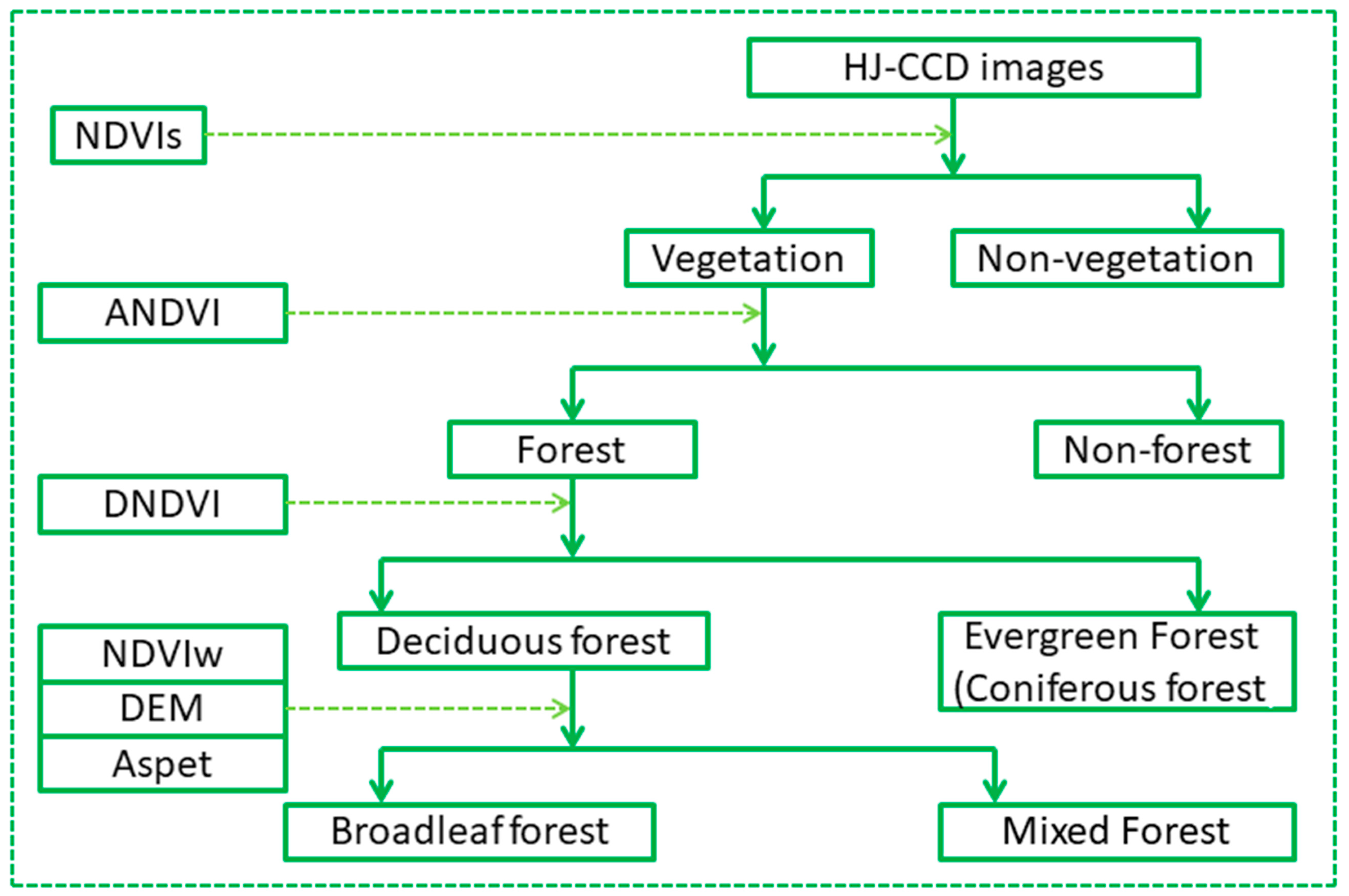
The OBIA technique extracts information on the basis of objects, a set of adjacent homogenous pixels, and objects have many important physical characteristics. Furthermore, the boundary shape is also more in line with the objective facts [
23,
24]. Therefore, the results of the forest extraction by the OBIA technique are smooth, compact, and consistent with the actual geological boundary. Moreover, the OBIA technique can not only use the spectral features of images, but also make full use of the spatial characteristics, texture, spatial structure, shape, and other characteristics [
23,
24]. Therefore, this technique can improve the extraction accuracy as it can, to a large extent, overcome the negative effects of the “same object with different spectra” and “different objects with the same spectrum”, which are caused by using only the spectral features in traditional pixel-based methods [
28,
29]. The overall accuracy of the classification results was 93.10%, and the Kappa coefficient was 0.89, indicating that the classification results presented high precision and good effects.
The existing studies on carbon storage in forest ecosystems mainly focus on the tree canopy layer, and little attention is paid on other forest layers [
30,
31]. Doing so underestimates, to some extent, the carbon storage in the forest ecosystem. Vegetation layers under the canopy, litter layer, and soil layer are all important components of forest ecosystems and play an important role in the carbon sequestration of the forest ecosystem [
32,
33,
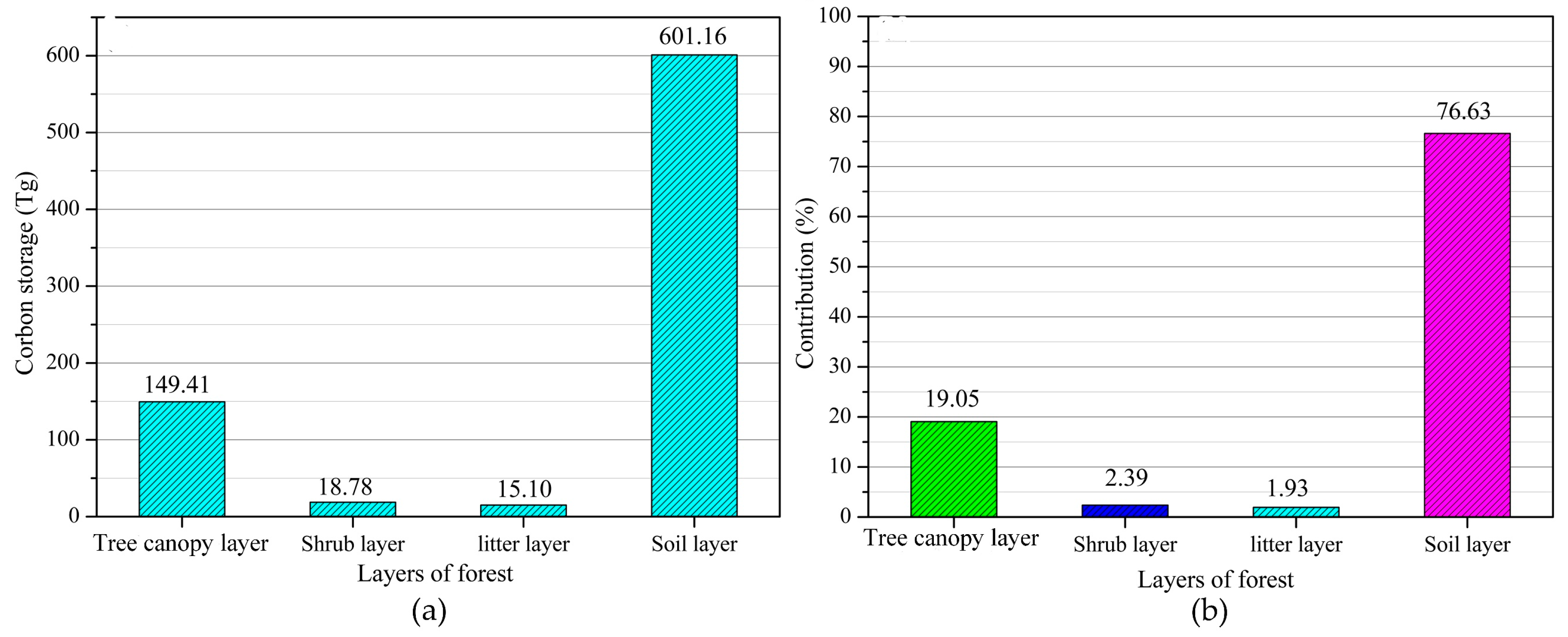
34]. Our research attempts to characterize the spatial pattern of carbon storage in the forest ecosystem in both the vertical and horizontal directions. The results showed that the forest carbon storage in Hubei Province was 784.46 Tg, and the carbon storage amounts in the vegetation layers (including tree canopy layer, shrub layer, and litter layer) and soil layer were 183.30 and 601.16 Tg, respectively. The total forest carbon storage in China is 9240.50 Tg [
35]. By this standard, the forest carbon storage in Hubei Province accounted for 8.49% of that in China. However, the forest statistical area of China is 1,954,522 km
2, and the forest area in Hubei Province only accounts for approximately 3.14% of that area [
36,
37]. In addition, shrubbery is frequently considered a forest type in the calculation of the total carbon storage on the national scale [
38]. However, in this study, shrubbery was excluded as a forest type. Thus, carbon storage in the vegetation layers was underestimated, and the actual contribution may exceed 8.40%. Carbon storage in the forest ecosystem in the Hubei Province is an important component of forest carbon storage in China.
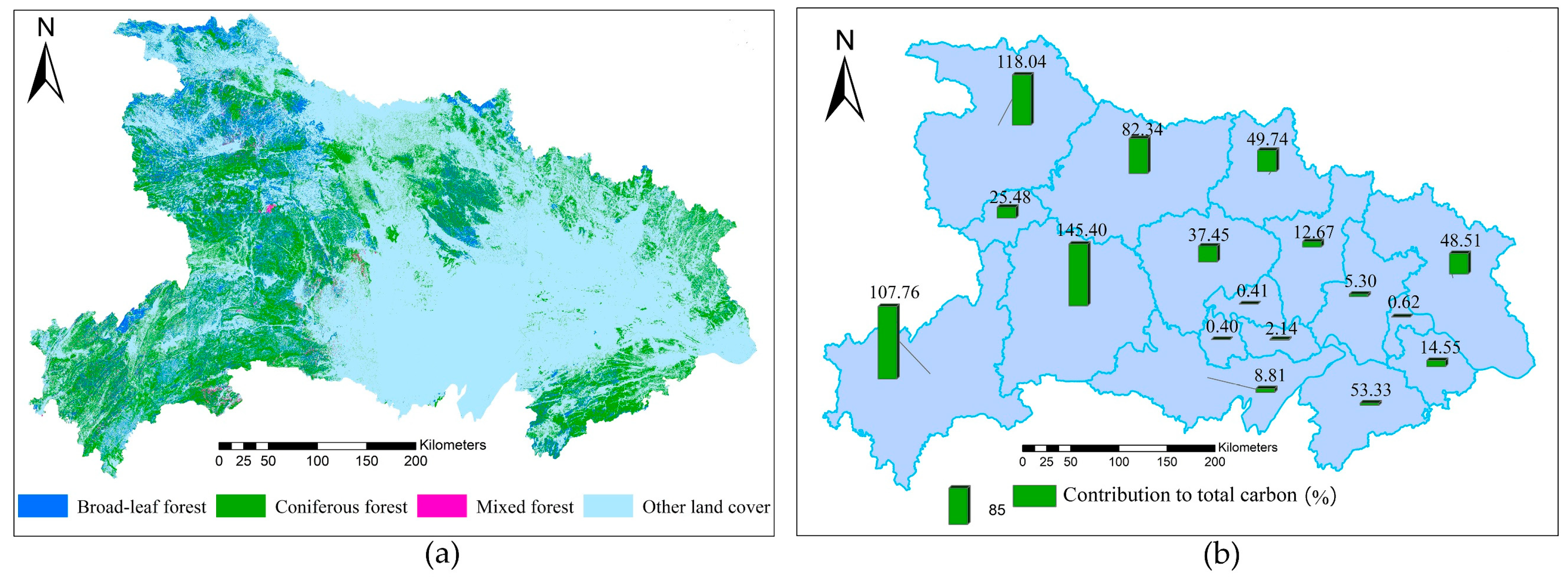
The distribution of forest carbon storage is closely related to the distribution of forests [
38,
39]. Enshi, Yichang, Shiyan, and Xiangfan in the west of Hubei Province contributed the most to the total forest carbon storage in Hubei Province, with contribution rates of 18.73%, 13.89%, 15.21%, and 10.61%, respectively. This result is mainly because the forests in Hubei Province are mainly distributed in the west, and most of the forests are in the west for three main reasons. Firstly, the western mountainous region of Hubei Province is China’s transition zone between the second and third terrain ladders and mainly includes the Wudang Mountains and the Daba Mountains, which consist of Shengnongjia, the Jing Mountain and the Wu Mountain [
40,
41,
42]. These areas have had little interference from human activities and changes in the distribution of the original forest [
43,
44]. Secondly, the mountain vertical zone regulation is significant, leading to differences in rainfall, radiation, wind, water vapor transmission, factors such as soil shape differences in the vertical direction; these differences are attributed to the high altitude of the mountains, which has an average altitude of above 1000 m [
19]. Thirdly, the western region of Hubei Province is the water source of China’s South-to-North Water Transfer Project (SNWTP), and the Danjiangkou Reservoir, which is the starting point of the SNWTP, is located in this region. To ensure the quality of the water ecological environment and water diversion, the government has taken various measures to protect forests, including the prohibition of deforestation and the reduction of interference from human activities [
39,
40].
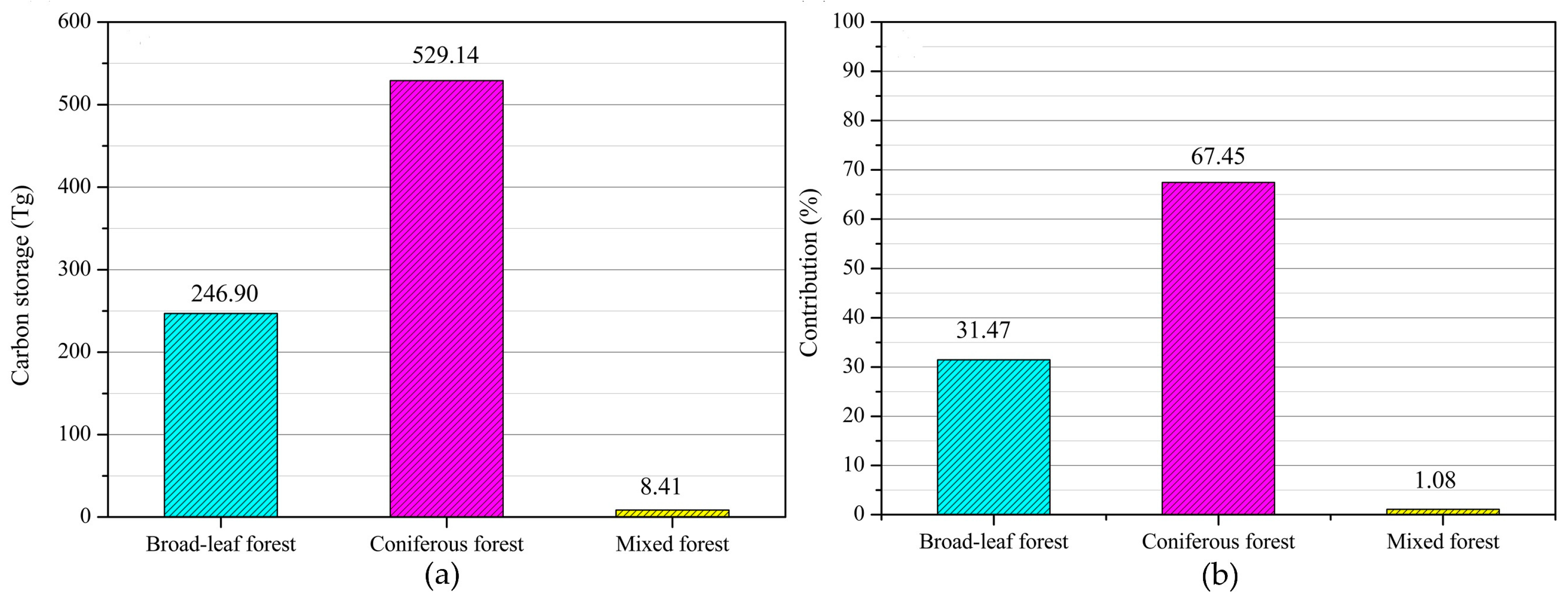
Coniferous forests, followed by broadleaf and mixed forests, provided the major contributions to the total carbon reserves in the study area. This result is consistent with the findings of Hu et al. [
41]. The carbon density of forest ecosystems is related to the composition, structure, and growth characteristics of forest vegetation. In addition, carbon storage in forest ecosystems is closely related to forest area [
40]. The carbon sequestration rate of vegetation in coniferous forests is not as high as that of vegetation in broadleaf forests (
Table 3) but is stable and persistent. Hence, the carbon density of coniferous forests is higher than that of broadleaf forests [
39,
42]. Meanwhile, coniferous forests are extensively distributed in Hubei Province and accounts for 71.35% of the total forest area of the province. Therefore, coniferous forests have the largest carbon storage and largest contribution to the forest carbon storage in Hubei Province. This also implies that Hubei Province has great potential for carbon sequestration. This is because Hubei Province has carried out large-scale conversion of farmland to forest and afforestation through ecological engineering since 2000, and the afforestation tree species are mainly coniferous forests [
39]. The area of the broadleaf forest is smaller than that of the coniferous forest (15,556.80 km
2 or 25.36% of the total forest area of Hubei Province). In addition, the carbon density of the broadleaf forest was larger than that of the mixed forest (
Table 3). Therefore, the carbon reserves of the broadleaf forest are higher than those of the mixed forest, which ranked second.
The vegetation layers in this study included the arbor, shrub, and litter layers [
5]. Generally speaking, the carbon storage in the forest vegetation layers was mainly from the influences of forest growth environment, forest age, forest type, and origin [
6,
39]. In this study, which used a remote sensing method, the carbon storage in the vegetation layers in Hubei Province was 183.30 Tg, which was higher than that in Hunan province (180.53 Tg) [
15], much higher than that in Henan Province (100.61 Tg) [
43], but significantly lower than those in Guangdong Province (215.55 Tg) and in Shanxi Province (238.52 Tg) [
44,
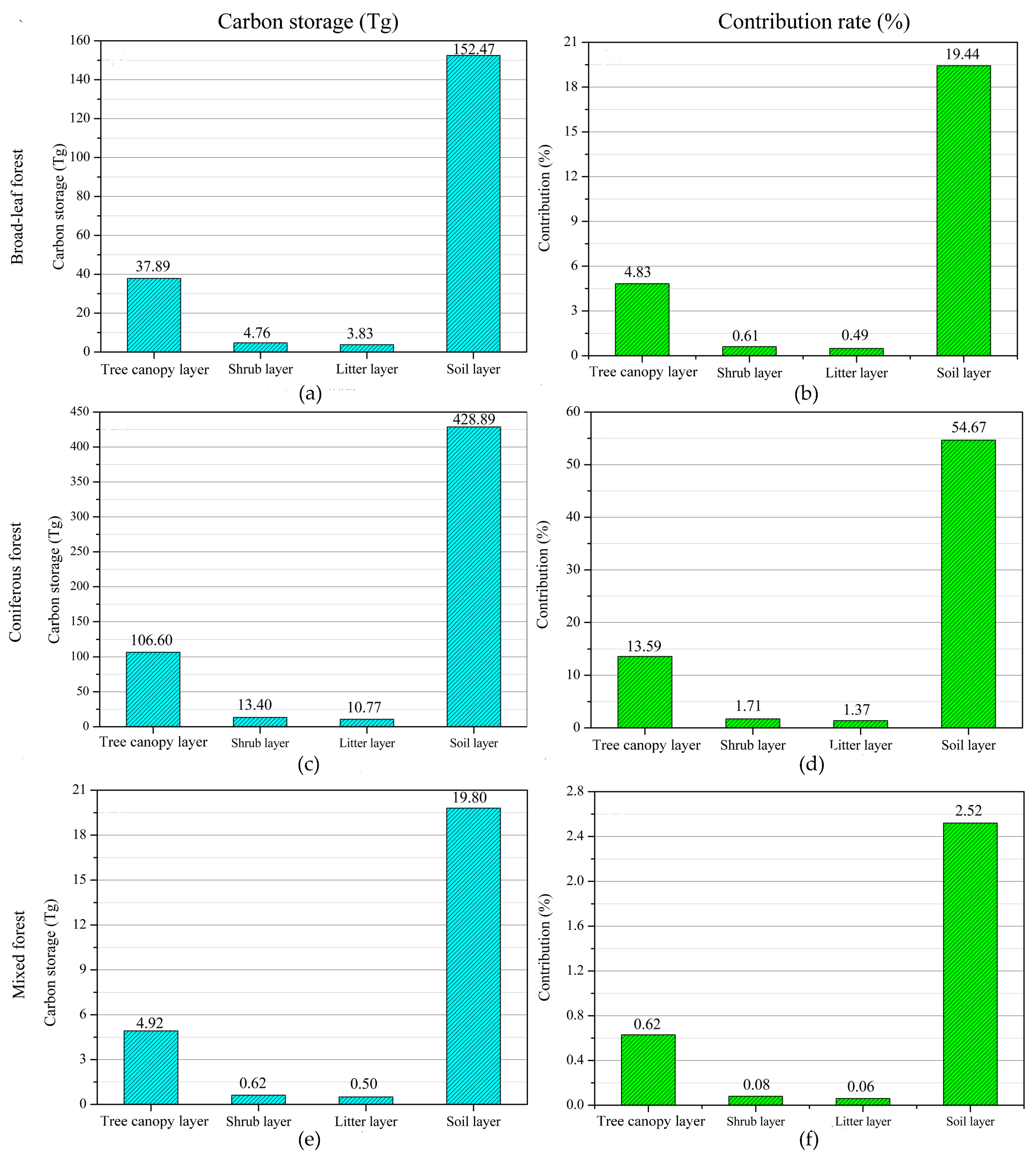
45]. This information indicates that carbon storage in the forest vegetation of Hubei Province plays an important role in carbon storage in China. Forest carbon reserves can be further increased through ecological engineering, such as afforestation. The vegetation layers in coniferous forests contributed the most (16.67% (130.77 Tg)) to the total carbon storage in Hubei Province, followed by that of the broadleaf forests, which had a contribution rate of 5.93% (46.49 Tg). The mixed forests had the least contribution. Therefore, the cultivation of mixed forests should be improved, and the healthy development of forest stands should be promoted in the future forest management process to enhance the forest carbon sink function of the region.
The contributions of the various vegetation layers in diverse types of forest to carbon storage in the study area considerably vary. The soil, arbor, litter, and shrub layers in the coniferous forests contributed the most to the total carbon storage in Hubei Province, with contribution rates of 54.57%, 13.59%, 1.71%, and 1.37%, respectively. The contribution of each layer in the broadleaf forests to the total carbon storage of the study area is greater than that of the corresponding layer in the mixed forests. The different types of forest exhibit a stratification phenomenon, and large differences exist in the structure and function, resulting in vertical hierarchies and eventually leading to a huge difference in the carbon storage capacity [
17,
46].
The carbon reserves in the soil layer in Hubei Province totaled 601.16 Tg, and its contribution to the total forest carbon storage in the study area was the largest, reaching 76.63%, which is 3.28 times that of the vegetation layers. The results of the current study are approximate to that of Zhou et al. [
47], indicating that the soil layer is indeed the largest carbon reservoir in the forest ecosystem of Hubei Province. Organic carbon is mainly concentrated in the soil and can be maintained for a long time because of slow turn speed; therefore, carbon deposits can be maintained for a long time and are protected by physical landscape [
48,
49]. However, carbon density, or the amount of carbon stored per unit area, is 99.54 t·hm
−2, which is well below the national average of 193.55 t·hm
−2. The low-carbon density of Hubei Province is mainly because the province is located in China’s subtropical region, where rainfall is abundant and concentrated. Furthermore, the mountainous area is wide, and its slope is large; thus, its soil erosion resistance is poor. In addition, many forests in the study area are artificial forests, where the quantity and quality of the return forest litter are low, and the management measures on soil disturbance accelerate the decomposition of soil organic matter or erosion, leading to the loss of soil carbon [
50,
51].
The present study has several limitations. The main limitation of this study is the non-inclusion of the herb layer in the vegetation layers because of the lack of relevant data. Therefore, the total carbon storage in Hubei Province may be higher than the estimated value, and the contribution rates of the different layers may be lower than the estimated values. However, we found in our three field sampling campaigns across Hubei Province that the herb layers under the forest are few, and most were simply litter layers. Therefore, ignoring the herbaceous layer has negligible effects on the results and conclusions. Meanwhile, remote sensing methods, instead of the field measurement method, were mainly adopted. Remote sensing methods are known to introduce certain errors in data acquisition, image processing, and other processes. Therefore, the present results will have certain errors. However, the spatial pattern of carbon reserves was mainly analyzed on the macroscale. This approach is one advantage of the remote sensing method over the field measurement method. Finally, the extraction accuracy of the forest information is extremely high. Therefore, the present results are accurate and reliable. In future studies, obtaining more measured data on a large scale will further improve the results.
5. Conclusions
Based on HJ-CCD remote sensing imagery and published field sampling data, we explored the variation in carbon in a provincial forest ecosystem in the vertical and horizontal directions. The following conclusions are drawn from this study:
(1) The carbon storage in the forest ecosystem in Hubei Province was 784.46 Tg. The forest carbon storage in Hubei Province assumes an important position in China, but this storage must still be improved considerably. Spatially, the Enshi Prefecture contributed the most, followed by Yichang, Shiyan, and Xiangfan. In terms of contribution, the coniferous forests contributed the most to the total carbon storage in forests, with a contribution rate of 71.34%, followed by the broadleaf and mixed forests. This result is attributed to the distribution of different types of forests in Hubei Province. Moreover, this finding implies that Hubei Province has considerable potential for carbon sequestration because the coniferous forests will continuously increase given a series of ecological projects implemented by the government.
(2) The stratification of forest carbon storage in the vertical direction was apparent in Hubei Province, that is, soil layer > arbor layer > shrub layer > litter layer. Soil layer had the largest carbon storage and contributed the most (76.63%), followed by the arbor layer, which accounted for 19.05% of the total carbon storage. However, the contribution rates of the shrub and litter layers to the total carbon reserves in Hubei Province were only 2.39% and 1.93%, respectively. These results were mainly attributed to the environmental differences in the vertical direction of forest ecosystems, thereby indicating that the arbor forest vegetation in Hubei province plays an important role in forest carbon storage and improving forest carbon sink function.
(3) The contributions of the different forest layers in the coniferous, broadleaf, and mixed forests to the total carbon storage showed the same trend, that is, soil layer > arbor layer > litter layer > shrub layer. The arbor, shrub, litter, and soil layers of the coniferous forests contributed the most to the forest carbon storage in Hubei Province, with contribution rates of 13.59%, 1.71%, 1.37%, and 54.67%, correspondingly.


