Integrating Multitemporal Sentinel-1/2 Data for Coastal Land Cover Classification Using a Multibranch Convolutional Neural Network: A Case of the Yellow River Delta


Abstract
1. Introduction
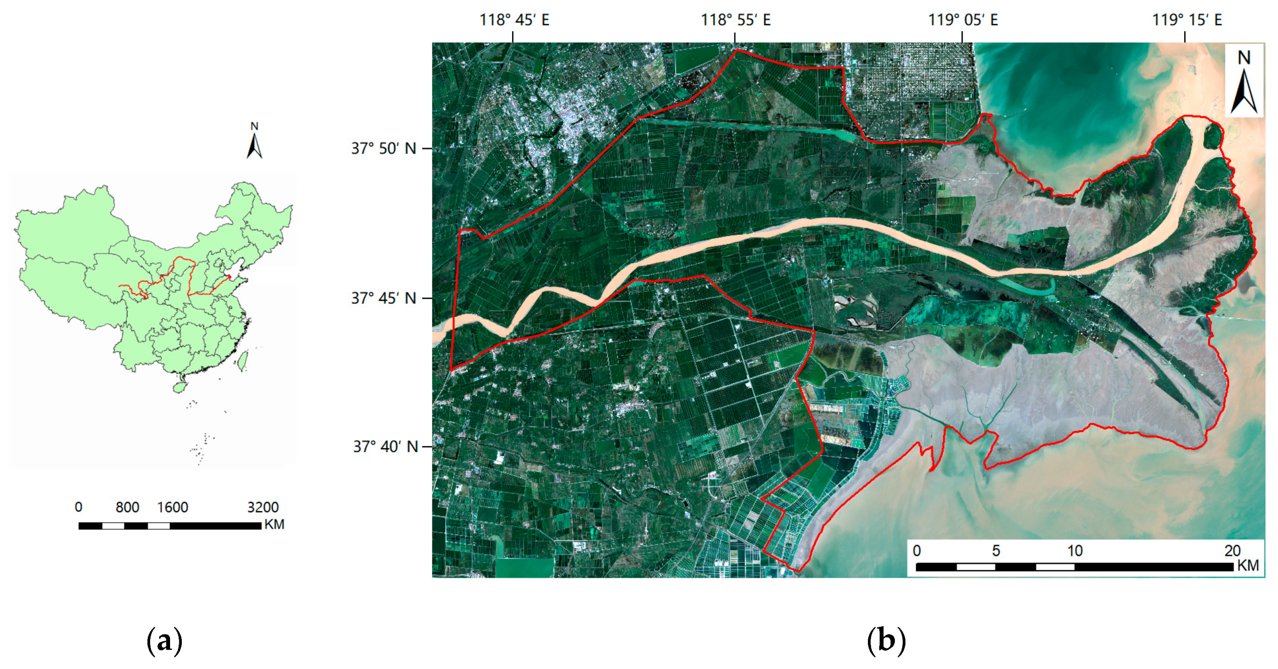
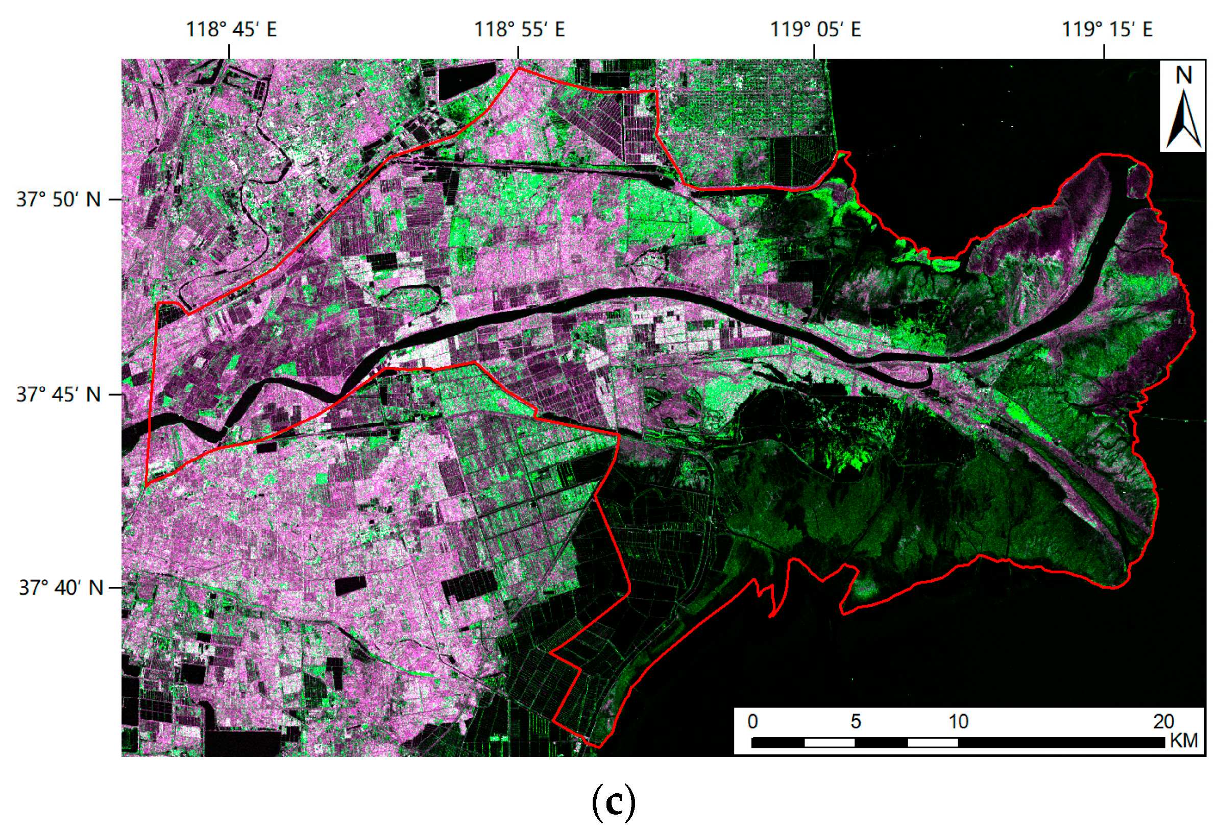
2. Study Area and Dataset
2.1. Study Area
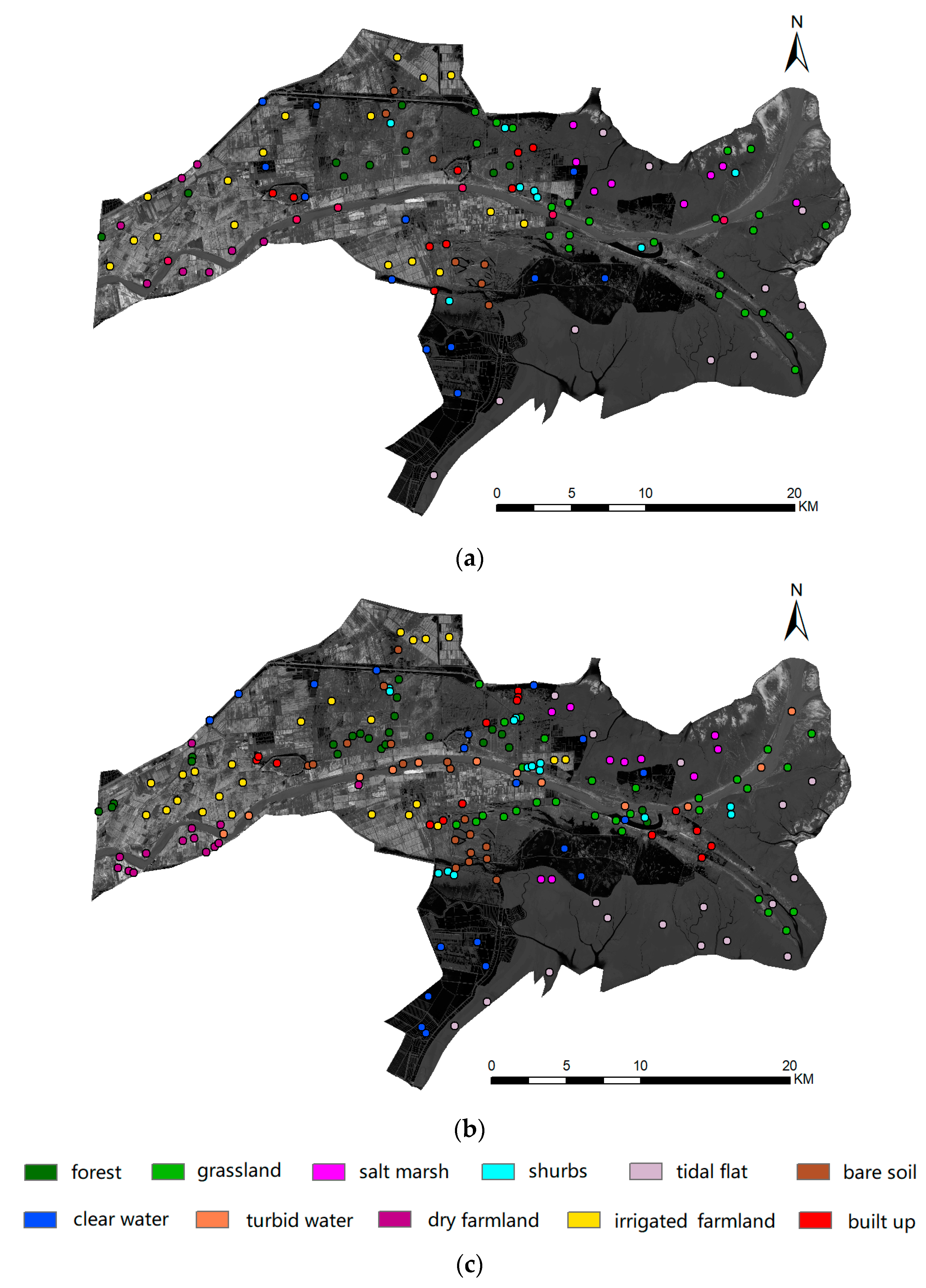
2.2. Dataset Used
3. Methods
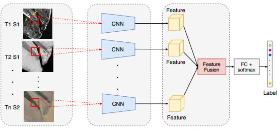
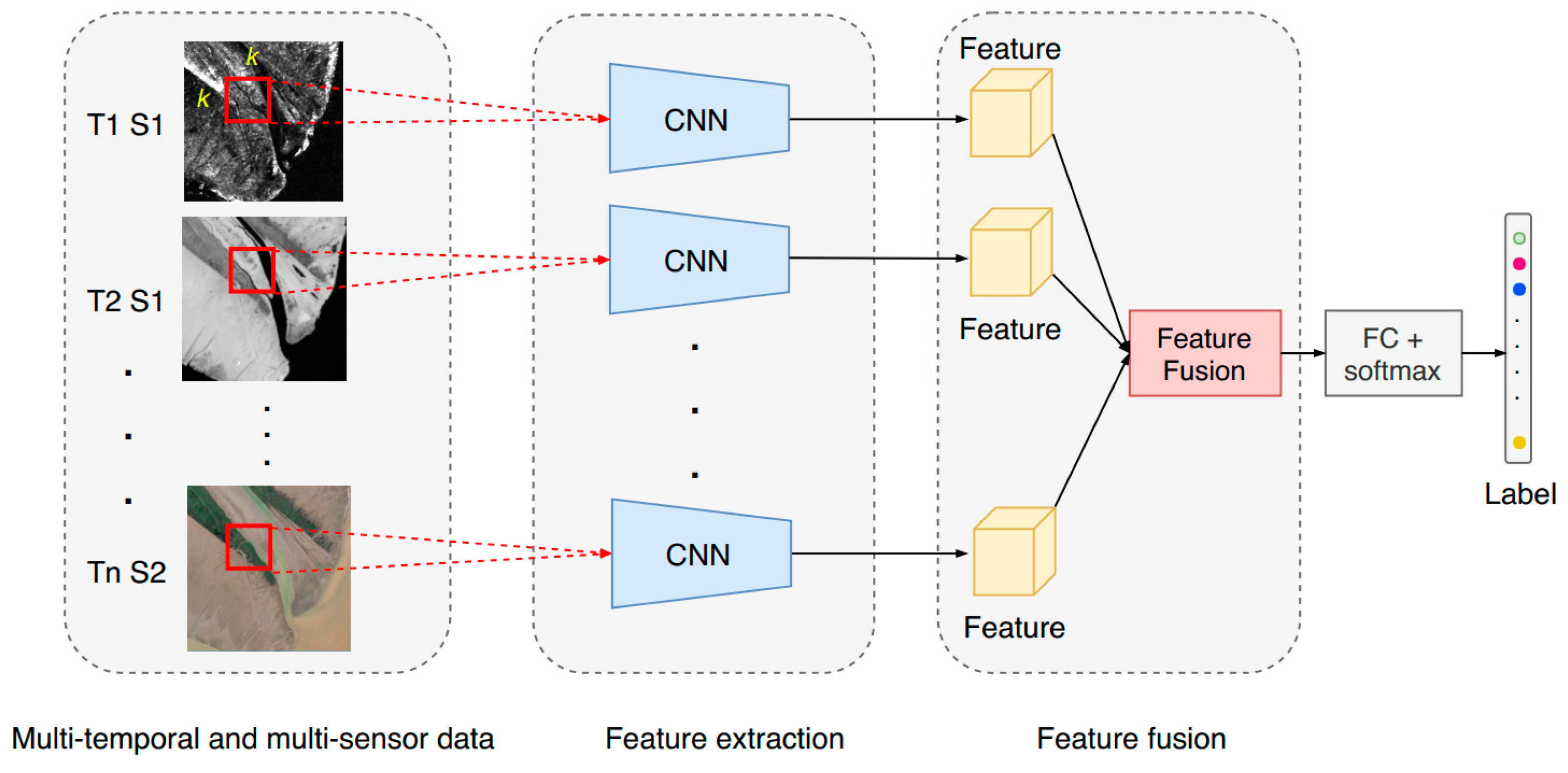
3.1. Overview of a Multibranch Convolutional Neural Network (CNN)
3.2. Brief Introduction of CNNs
3.2.1. Convolutional Layers
3.2.2. Pooling Layers
3.2.3. Fully Connected Layers
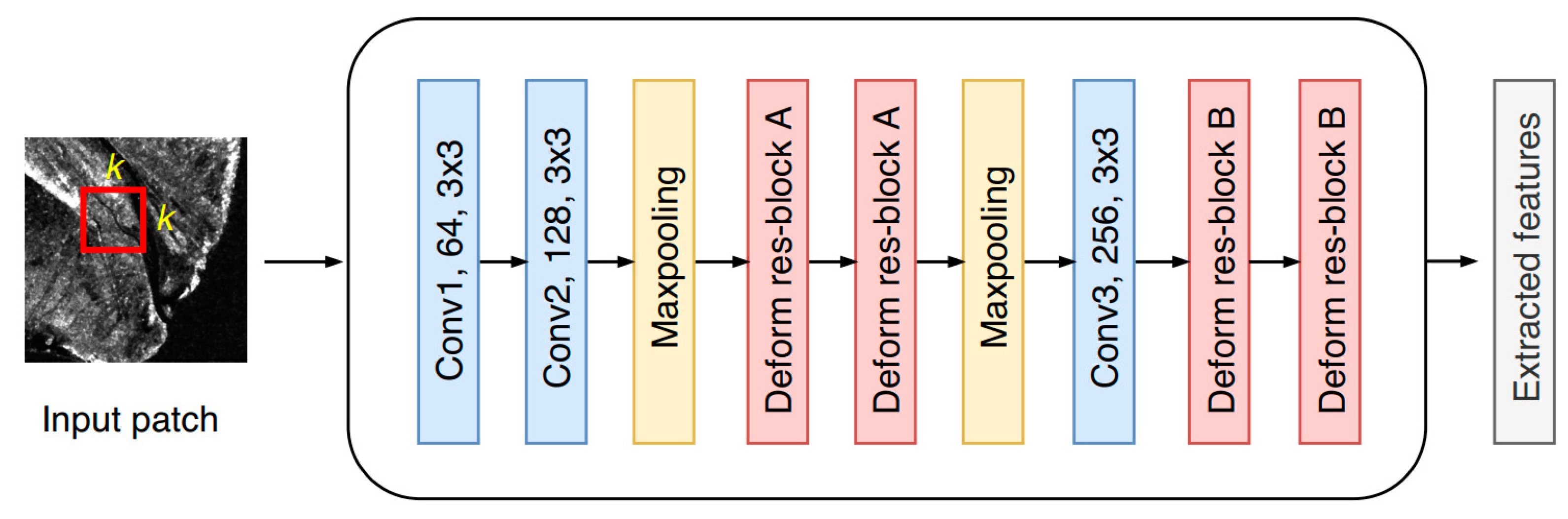
3.3. Single-Branch CNN for Feature Extraction
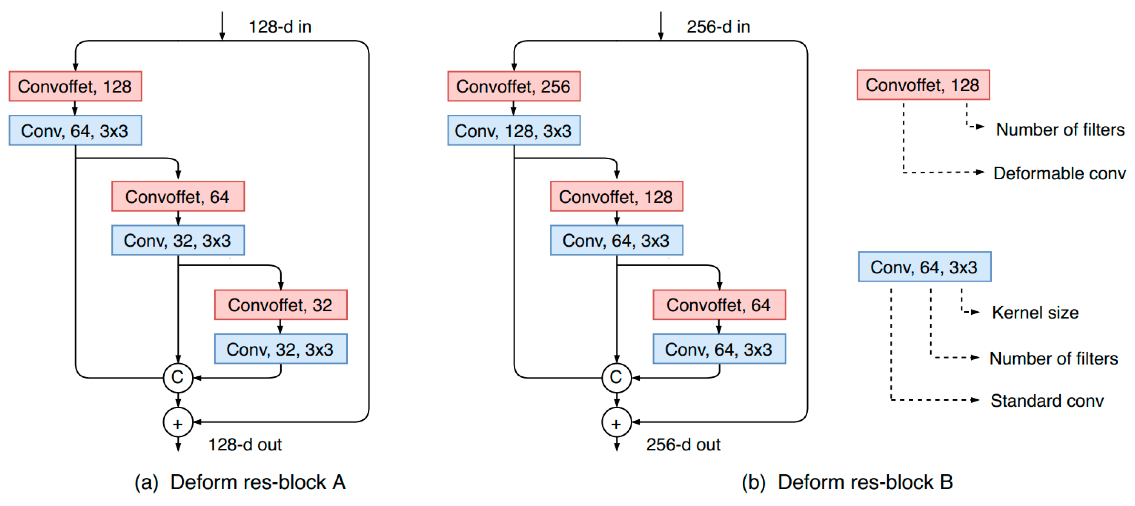
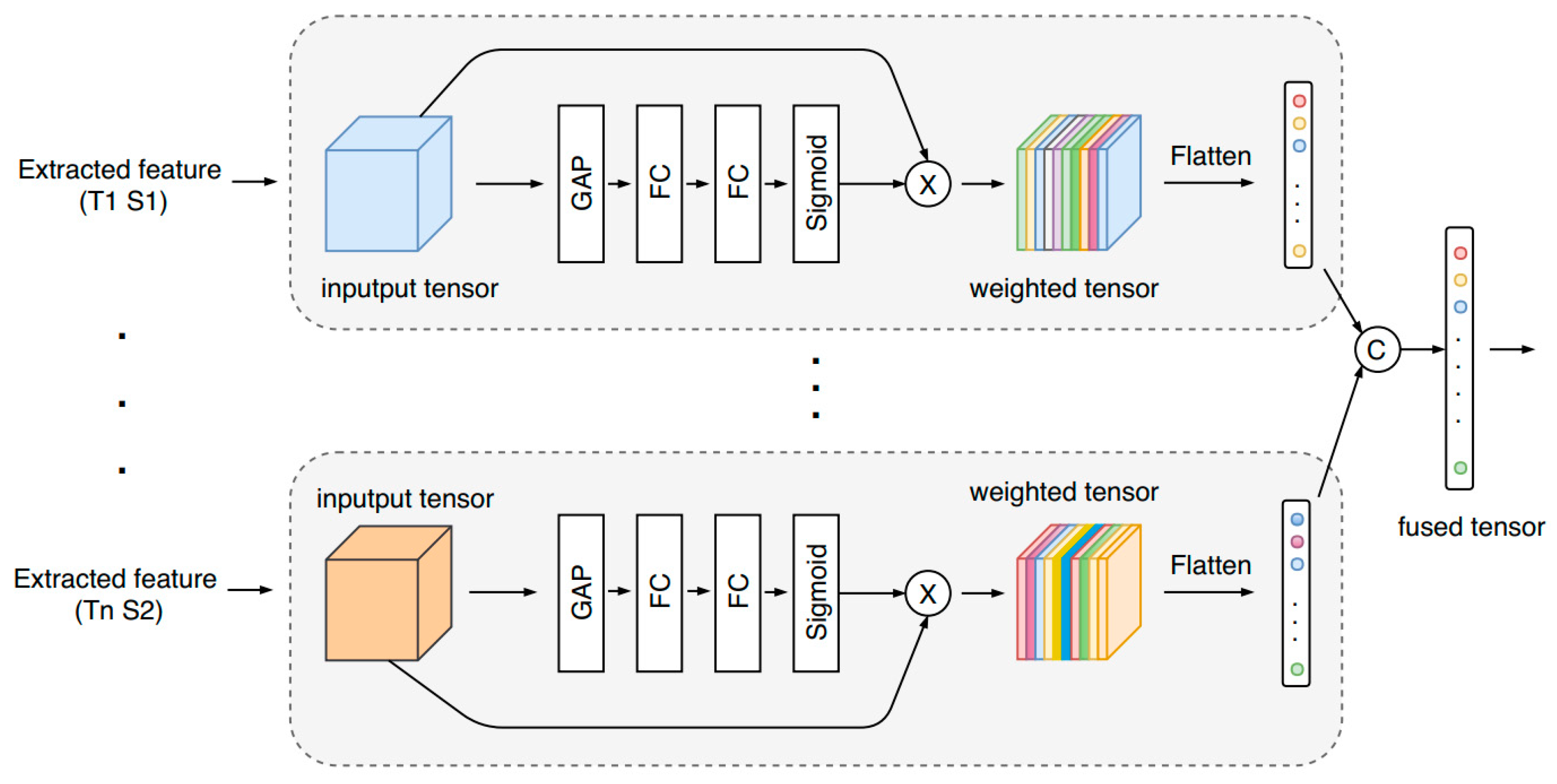
3.4. Adaptive Feature Fusion
3.5. Details of Network Training
3.6. Accuracy Assessment
4. Results and Discussion
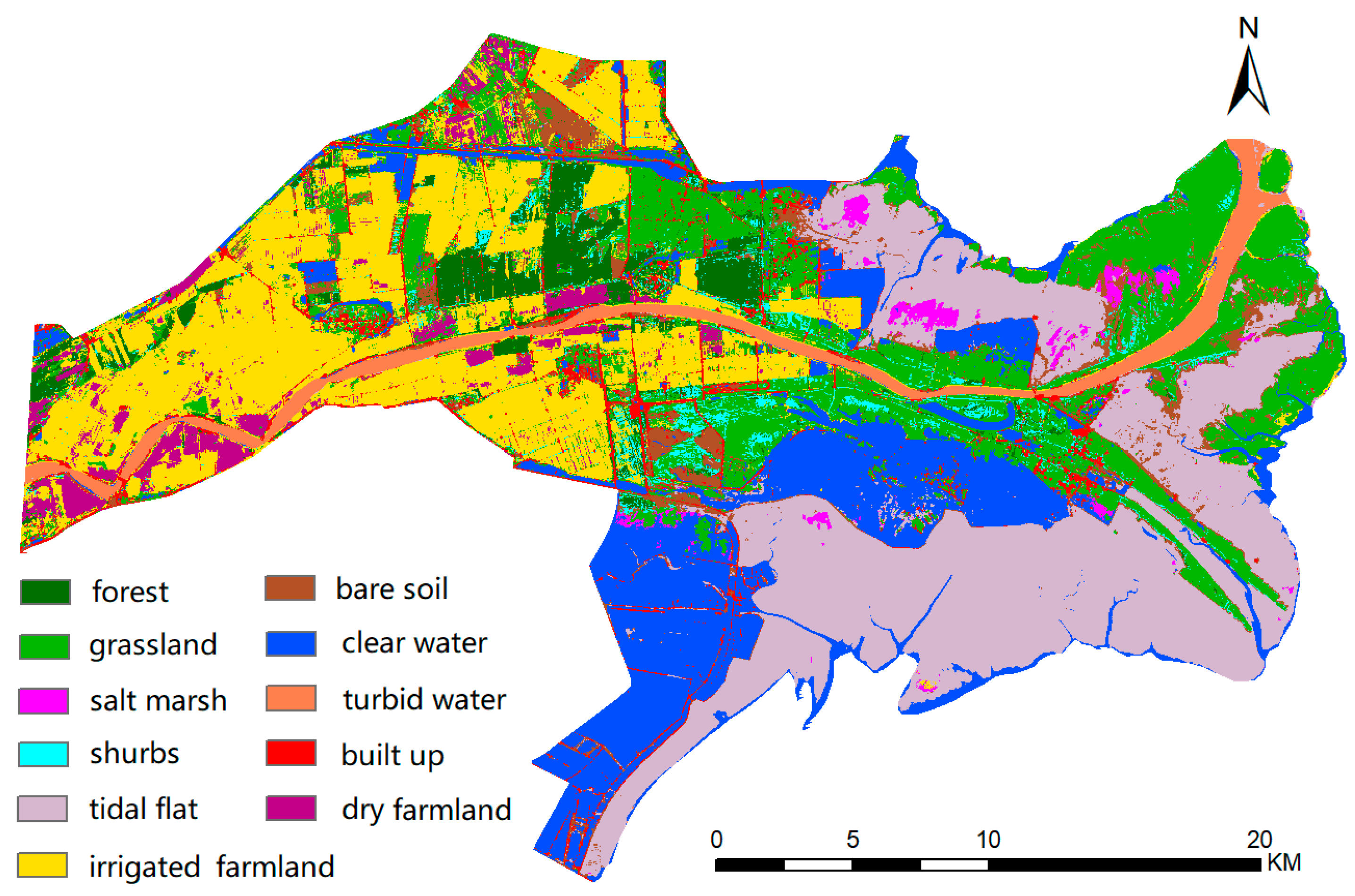
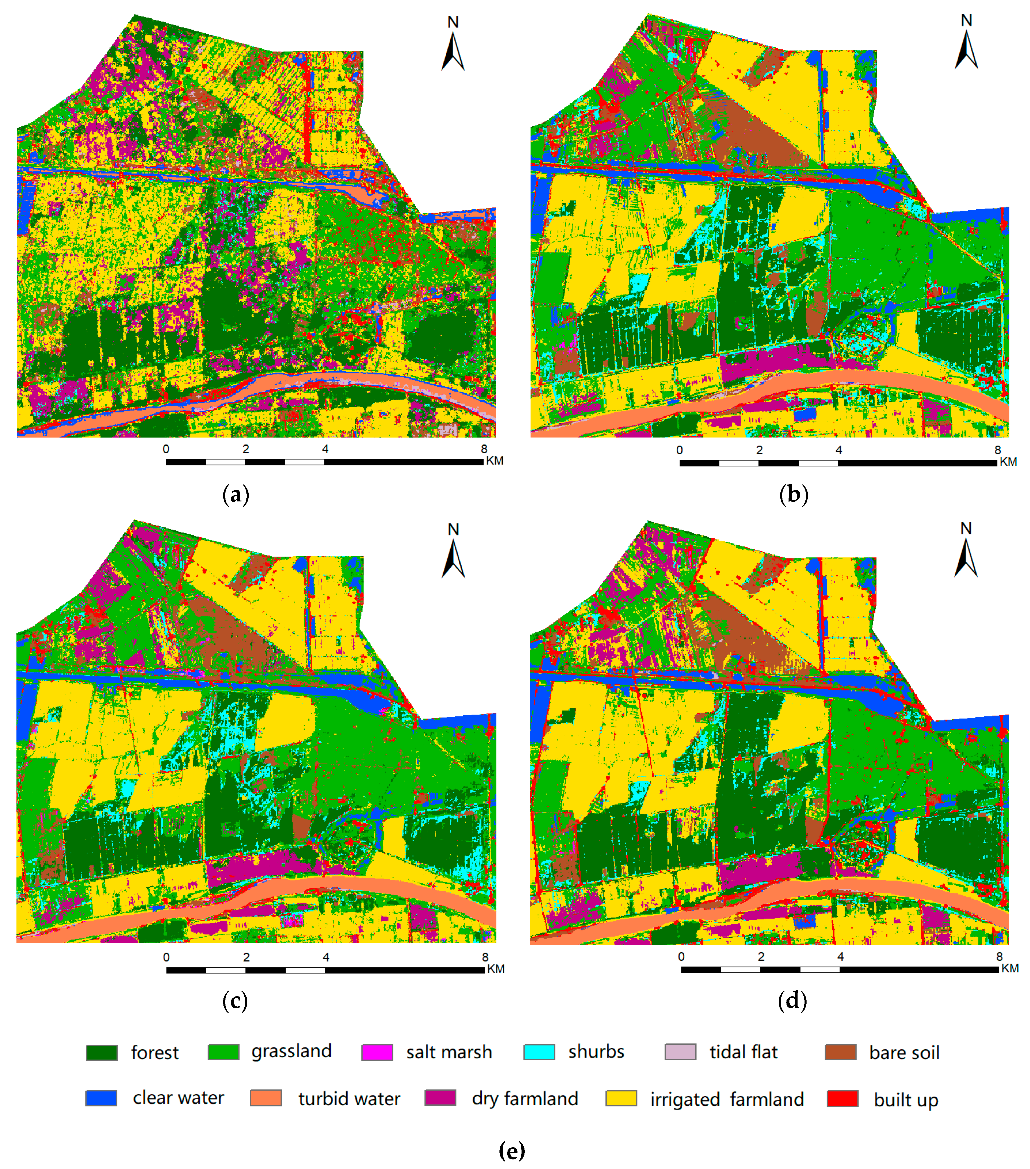
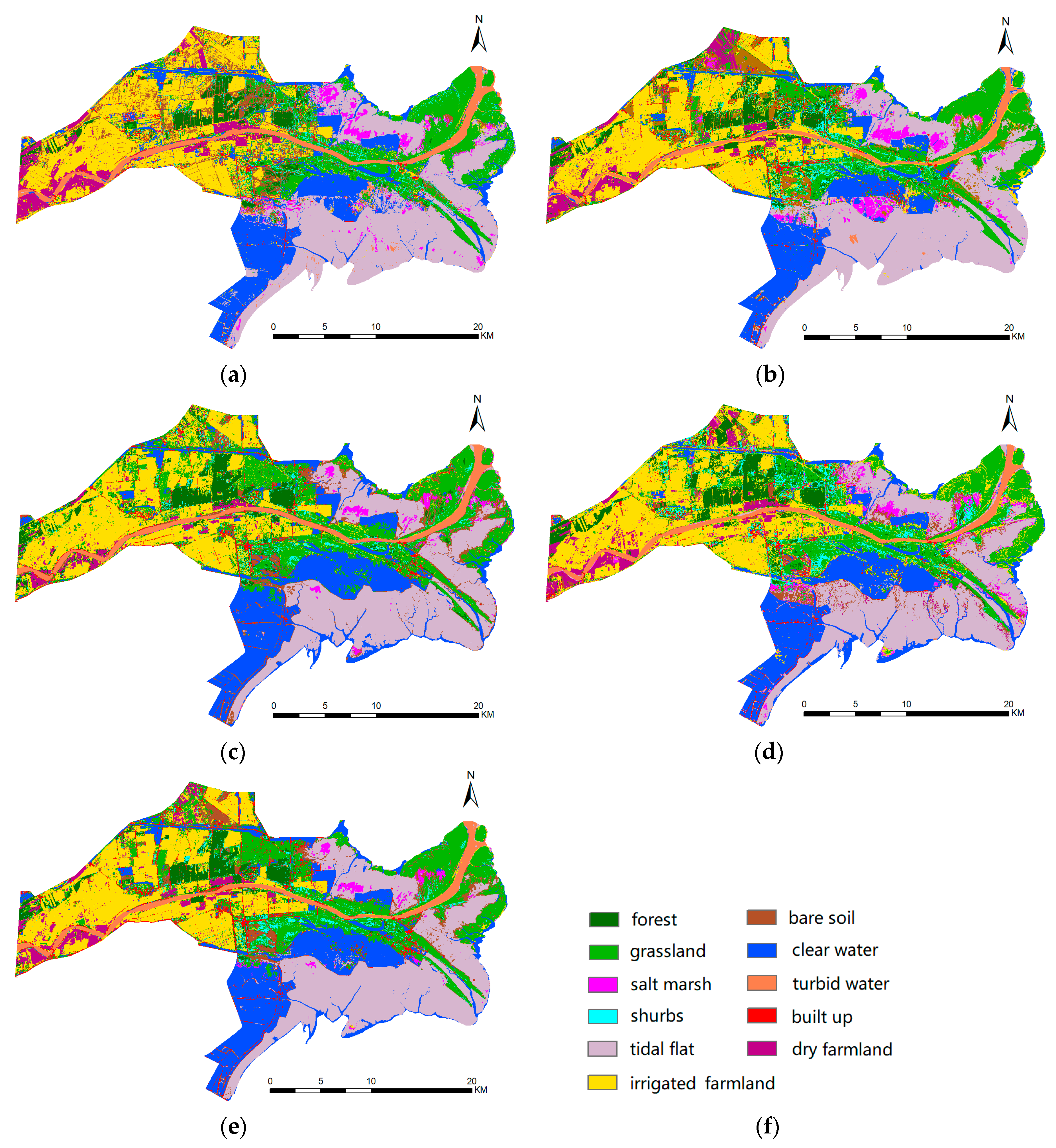
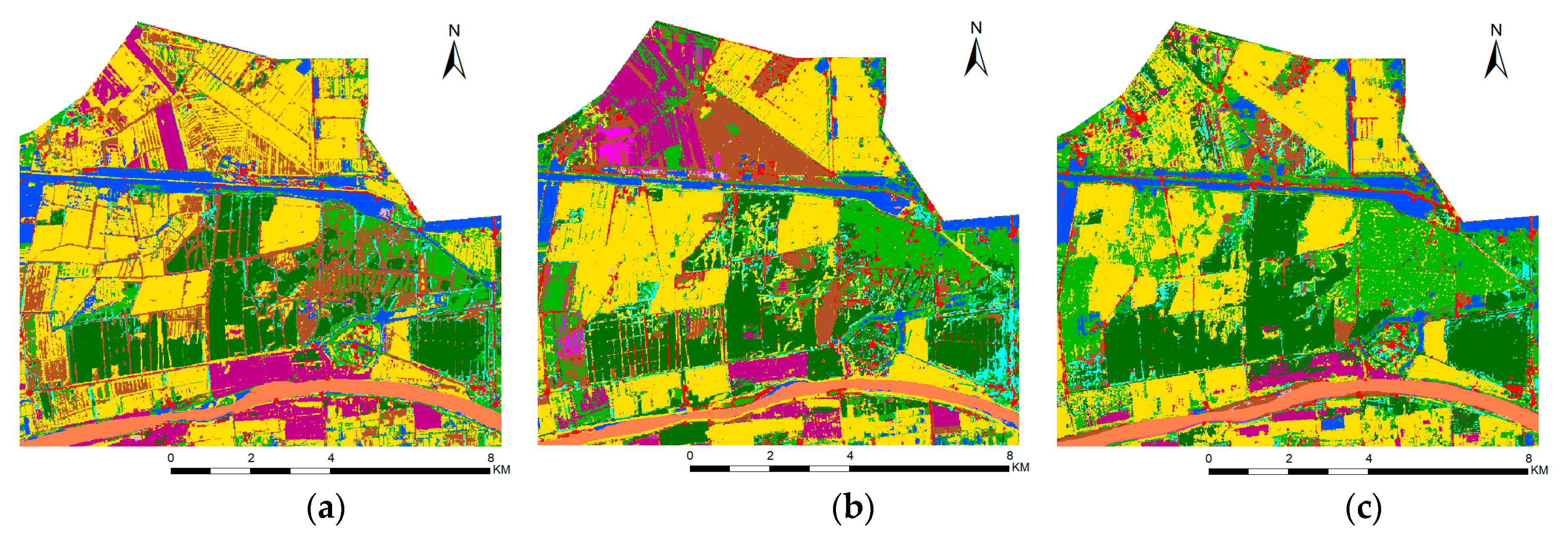
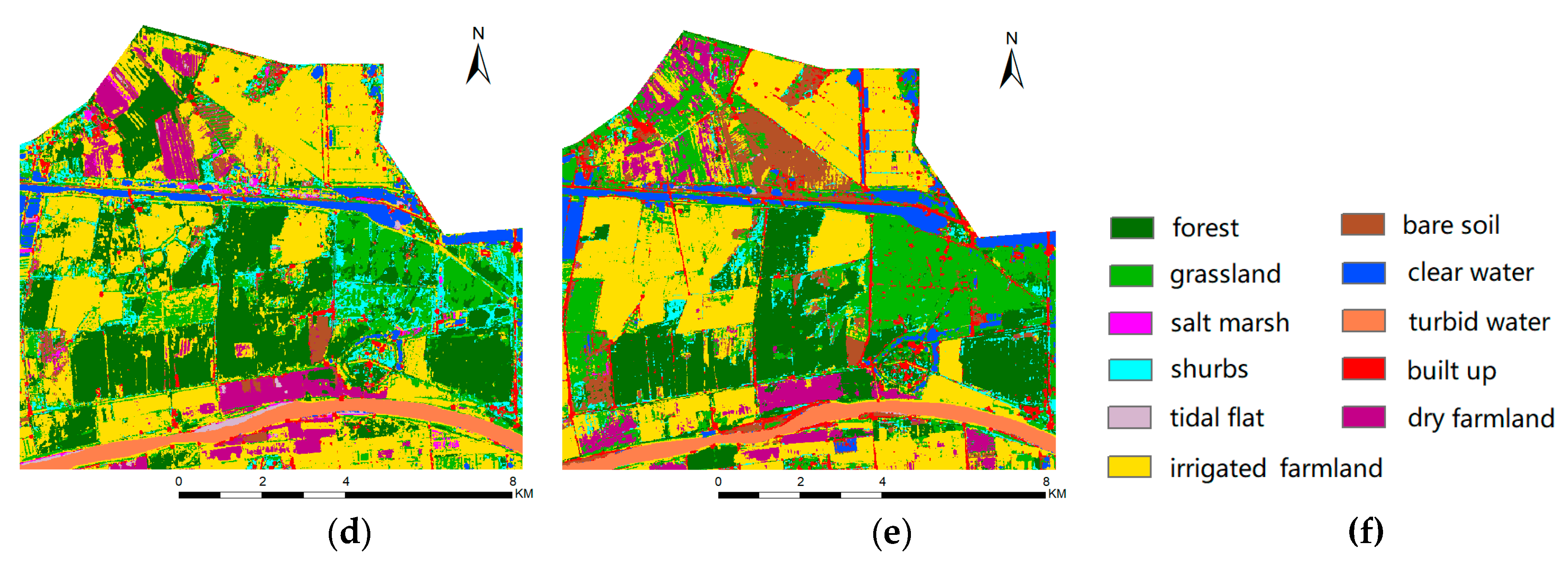
4.1. Results of Coastal Land Cover Classification
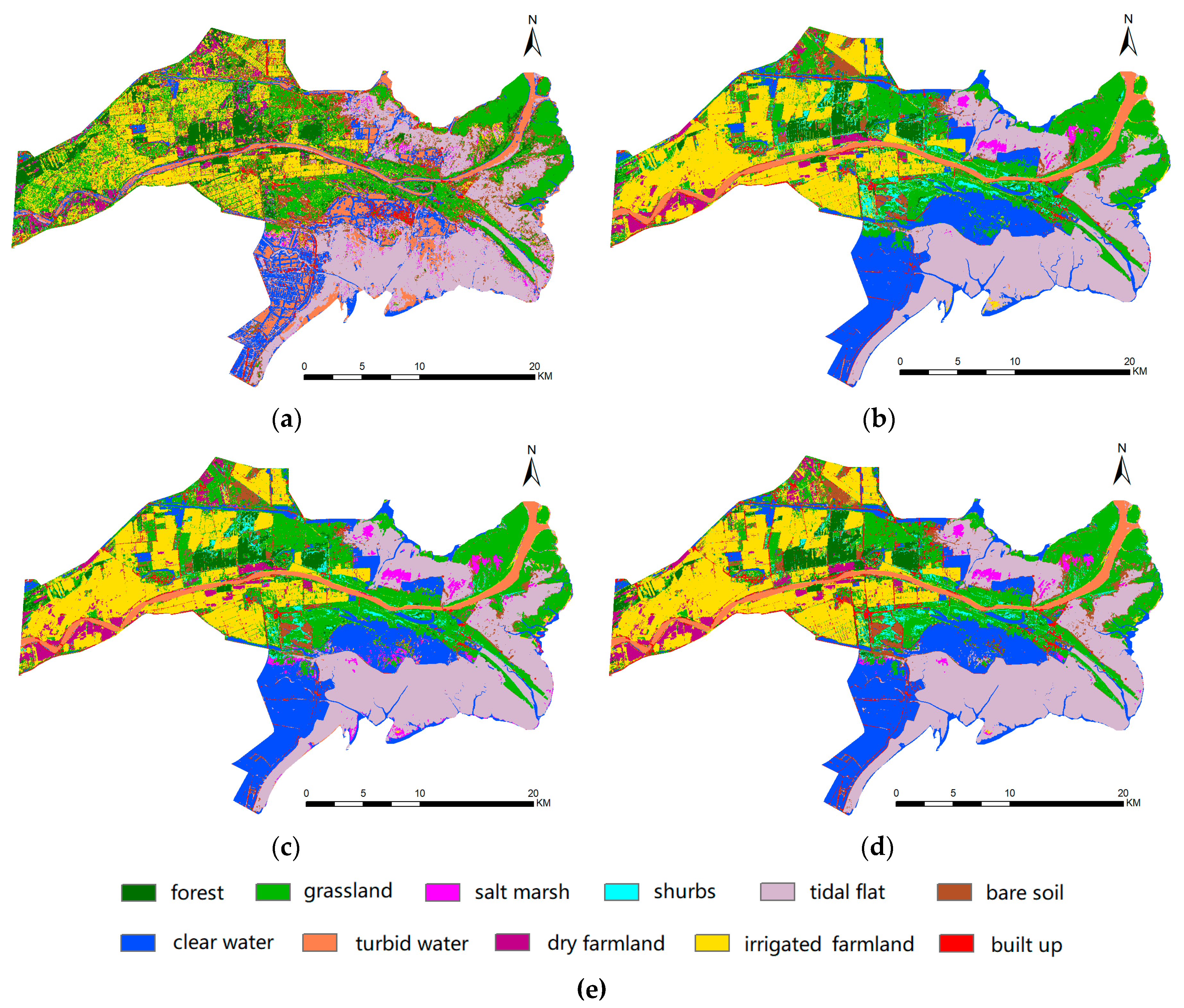
4.2. Impact of Multisensor Data on Classification
4.3. Impact of Multitemporal Data on Classification
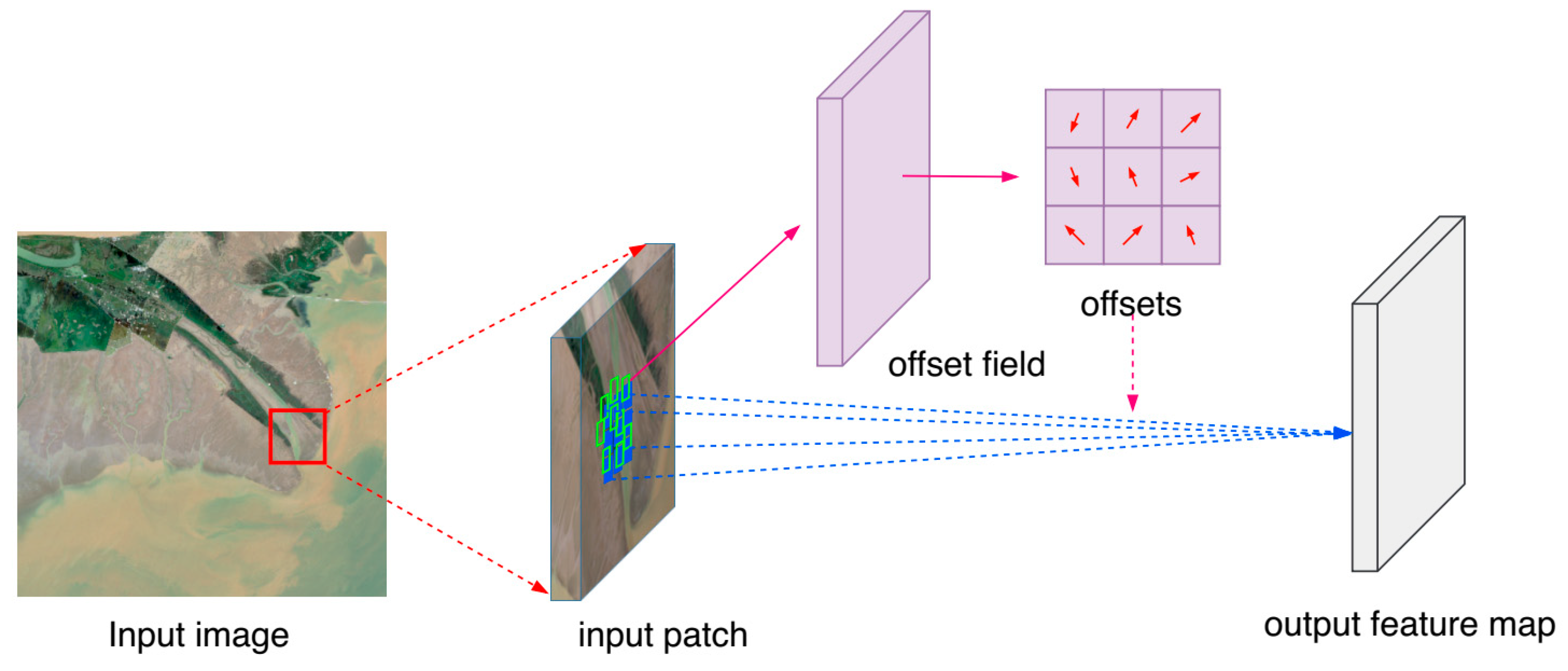
4.4. Impact of Deformable Convolution on Classification
4.5. Comparison with Machine Learning Methods
4.6. Comparison with Other Land Cover Classification Methods
5. Conclusions
Author Contributions
Funding
Acknowledgments
Conflicts of Interest
References
- Kuenzer, C.; Klein, I.; Ullmann, T.; Georgiou, E.; Baumhauer, R.; Dech, S. Remote Sensing of River Delta Inundation: Exploiting the Potential of Coarse Spatial Resolution, Temporally-Dense MODIS Time Series. Remote Sens. 2015, 7, 8516–8542. [Google Scholar] [CrossRef]
- Islam, M.R.; Miah, M.G.; Inoue, Y. Analysis of Land use and Land Cover Changes in the Coastal Area of Bangladesh using Landsat Imagery. Land Degrad. Develop. 2016, 27, 899–909. [Google Scholar] [CrossRef]
- Torbick, N.; Salas, W. Mapping agricultural wetlands in the Sacramento Valley, USA with satellite remote sensing. Wetlands Ecol. Manag. 2015, 23, 79–94. [Google Scholar] [CrossRef]
- Henderson, F.; Lewis, A. Radar detection of wetland ecosystems: a review. Int. J. Remote Sens. 2008, 29, 5809–5835. [Google Scholar] [CrossRef]
- Mahdavi, S.; Salehi, B.; Granger, J.; Amani, M.; Brisco, B.; Huang, W. Remote sensing for wetland classification: a comprehensive review. GISci. Remote Sens. 2018, 55, 623–658. [Google Scholar] [CrossRef]
- Davranche, A.; Lefebvre, G.; Poulin, B. Wetland monitoring using classification trees and SPOT-5 seasonal time series. Remote Sens. Environ. 2010, 114, 552–562. [Google Scholar] [CrossRef]
- Yang, X.; Chen, L.; Li, Y.; Xi, W.; Chen, L. Rule-based land use/land cover classification in coastal areas using seasonal remote sensing imagery: a case study from Lianyungang City, China. Environ. Monit. Assess. 2015, 187, 449. [Google Scholar] [CrossRef]
- Feng, Q.; Gong, J.; Liu, J.; Li, Y. Monitoring Cropland Dynamics of the Yellow River Delta based on Multi-Temporal Landsat Imagery over 1986 to 2015. Sustainability 2015, 7, 14834–14858. [Google Scholar] [CrossRef]
- Rodrigues, S.W.P.; Souza-Filho, P.W.M. Use of multi-sensor data to identify and map tropical coastal wetlands in the Amazon of Northern Brazil. Wetlands. 2011, 31, 11–23. [Google Scholar] [CrossRef]
- Beijma, S.; Comber, A.; Lamb, A. Random forest classification of salt marsh vegetation habitats using quad-polarimetric airborne SAR, elevation and optical RS data. Remote Sens. Environ. 2014, 149, 118–129. [Google Scholar] [CrossRef]
- Corcoran, J.; Knight, J.; Gallant, A. Influence of Multi-Source and Multi-Temporal Remotely Sensed and Ancillary Data on the Accuracy of Random Forest Classification of Wetlands in Northern Minnesota. Remote Sens. 2013, 5, 3212–3238. [Google Scholar] [CrossRef]
- Lane, C.R.; Liu, H.; Autrey, B.C.; Anenkhonov, O.A.; Chepinoga, V.V.; Wu, Q. Improved Wetland Classification Using Eight-Band High Resolution Satellite Imagery and a Hybrid Approach. Remote Sens. 2014, 6, 12187–12216. [Google Scholar] [CrossRef]
- Franklin, S.E.; Skeries, E.M.; Stefanuk, M.A.; Ahmed, O.S. Wetland classification using Radarsat-2 SAR quad-polarization and Landsat-8 OLI spectral response data: a case study in the Hudson Bay Lowlands Ecoregion. Int. J. Remote Sens. 2018, 39, 1615–1627. [Google Scholar] [CrossRef]
- Hird, J.N.; DeLancey, E.R.; McDermid, G.J.; Kariyeva, J. Google Earth Engine, Open-Access Satellite Data, and Machine Learning in Support of Large-Area Probabilistic Wetland Mapping. Remote Sens. 2019, 11, 43. [Google Scholar] [CrossRef]
- Mahdianpari, M.; Salehi, B.; Mohammadimanesh, F.; Homayouni, S.; Gill, E. The First Wetland Inventory Map of Newfoundland at a Spatial Resolution of 10 m Using Sentinel-1 and Sentinel-2 Data on the Google Earth Engine Cloud Computing Platform. Remote Sens. 2017, 9, 1315. [Google Scholar] [CrossRef]
- Erinjery, J.J.; Singh, M.; Kent, R. Mapping and assessment of vegetation types in the tropical rainforests of the Western Ghats using multispectral Sentinel-2 and SAR Sentinel-1 satellite imagery. Remote Sens. Environ. 2018, 216, 345–354. [Google Scholar] [CrossRef]
- Hajj, M.E.; Baghdadi, N.; Zribi, M.; Bazzi, H. Synergic Use of Sentinel-1 and Sentinel-2 Images for Operational Soil Moisture Mapping at High Spatial Resolution over Agricultural Areas. Remote Sens. 2017, 9, 1292. [Google Scholar] [CrossRef]
- Tricht, K.V.; Gobin, A.; Gilliams, S.; Piccard, I. Synergistic Use of Radar Sentinel-1 and Optical Sentinel-2 Imagery for Crop Mapping: A Case Study for Belgium. Remote Sens. 2018, 10, 1642. [Google Scholar] [CrossRef]
- Muller-Wilm, U. Sentinel-2 MSI – Level-2A Prototype Processor Installation and User Manual. 2016. Telespazio VEGA Deutschland GmbH, Darmstadt. Available online: http://step.esa.int/thirdparties/sen2cor/2.2.1/S2PAD-VEGA-SUM-0001-2.2.pdf (accessed on 27 April 2019).
- LeCun, Y.; Bengio, Y.; Hinton, G. Deep learning. Nature 2015, 521, 436–444. [Google Scholar] [CrossRef]
- Krizhevsky, A.; Sutskever, I.; Hinton, G.E. Imagenet classification with deep convolutional neural networks. Proc. Adv. Neural Inf. Process. Syst. 2012, 1097–1105. [Google Scholar] [CrossRef]
- Bulat, A.; Tzimiropoulos, G. Binarized Convolutional Landmark Localizers for Human Pose Estimation and Face Alignment with Limited Resources. Proc. IEEE Int. Conf. Comput. Vis. 2017, 3706–3714. [Google Scholar]
- Dai, J.; Qi, H.; Xiong, Y.; Li, Y.; Zhang, G.; Hu, H.; Wei, Y. Deformable Convolutional Networks. Arxiv 2017 [1703.06211]. Available online: https://arxiv.org/pdf/1703.06211.pdf (accessed on 27 April 2019).
- Jin, Q.; Meng, Z.; Pham, T.D.; Chen, Q.; Wei, L.; Su, R. DUNet: A Deformable Network for Retinal Vessel Segmentation. Arxiv 2018 [1811.01206]. Available online: https://arxiv.org/pdf/1811.01206.pdf (accessed on 27 April 2019).
- Hu, J.; Shen, L.; Sun, G. Squeeze-and-Excitation Networks. Arxiv 2017 [1709.01507]. Available online: https://arxiv.org/pdf/1709.01507.pdf (accessed on 27 April 2019).
- Lin, T.Y.; Goyal, P.; Girshick, R.; He, K.; Dollar, P. Focal loss for dense object detection. Proc. IEEE Int. Conf. Comput. Vis. 2017, 2999–3007. [Google Scholar]
- Zhu, X.; Tuia, D.; Mou, L.; Xia, G.; Zhang, L.; Xu, F.; Fraundorfer, F. Deep Learning in Remote Sensing: A Comprehensive Review and List of Resources. IEEE Geosci. Remote Sens. M. 2017, 5, 8–36. [Google Scholar] [CrossRef]
- Pan, X.; Gao, L.; Marinoni, A.; Zhang, B.; Yang, F.; Gamba, P. Semantic Labeling of High Resolution Aerial Imagery and LiDAR Data with Fine Segmentation Network. Remote Sens. 2018, 10, 743. [Google Scholar] [CrossRef]
- Huang, B.; Zhao, B.; Song, Y. Urban land-use mapping using a deep convolutional neural network with high spatial resolution multispectral remote sensing imagery. Remote Sens. Environ. 2018, 214, 73–86. [Google Scholar] [CrossRef]
- Feng, Q.; Zhu, D.; Yang, J.; Li, B. Multisource Hyperspectral and LiDAR Data Fusion for Urban Land-Use Mapping based on a Modified Two-Branch Convolutional Neural Network. ISPRS Int. J. Geo-Inf. 2019, 8, 28. [Google Scholar] [CrossRef]
- Ghamisi, P.; Hofle, B.; Zhu, X. Hyperspectral and LiDAR Data Fusion Using Extinction Profiles and Deep Convolutional Neural Network. IEEE J. Sel. Top. Appl. Earth Obs. Remote Sens. 2017, 10, 3011–3024. [Google Scholar] [CrossRef]
- Hughes, L.H.; Schmitt, M.; Mou, L.; Wang, Y.; Zhu, X. Identifying Corresponding Patches in SAR and Optical Images with a Pseudo-Siamese CNN. IEEE Geosci. Remote Sens. Lett. 2018, 15, 784–788. [Google Scholar] [CrossRef]
- Xu, X.; Li, W.; Ran, Q.; Du, Q.; Gao, L.; Zhang, B. Multisource Remote Sensing Data Classification Based on Convolutional Neural Network. IEEE Trans. Geosci. Remote Sens. 2018, 56, 937–949. [Google Scholar] [CrossRef]
- Rezaee, M.; Mahdianpari, M.; Zhang, Y.; Salehi, B. Deep Convolutional Neural Network for Complex Wetland Classification Using Optical Remote Sensing Imagery. IEEE J. Sel. Top. Appl. Earth Obs. Remote Sens. 2018, 11, 3030–3039. [Google Scholar] [CrossRef]
- Rußwurm, M.; Körner, M. Multi-Temporal Land Cover Classification with Sequential Recurrent Encoders. ISPRS Int. J. Geo-Inf. 2018, 7, 129. [Google Scholar] [CrossRef]
- Ji, S.; Zhang, C.; Xu, A.; Shi, Y.; Duan, Y. 3D Convolutional Neural Networks for Crop Classification with Multi-Temporal Remote Sensing Images. Remote Sens. 2018, 10, 75. [Google Scholar] [CrossRef]
- Scarpa, G.; Gargiulo, M.; Mazza, A.; Gaetano, R. A CNN-Based Fusion Method for Feature Extraction from Sentinel Data. Remote Sens. 2018, 10, 236. [Google Scholar] [CrossRef]
- Mahdianpari, M.; Salehi, B.; Rezaee, M.; Mohammadimanesh, F.; Zhang, Y. Very Deep Convolutional Neural Networks for Complex Land Cover Mapping Using Multispectral Remote Sensing Imagery. Remote Sens. 2018, 10, 1119. [Google Scholar] [CrossRef]
- Yang, J.; Ren, G.; Ma, Y.; Fan, Y. Coastal wetland classification based on high resolution SAR and optical image fusion. Proc. IEEE Int. Conf. Comput. Vis. 2016, 886–889. [Google Scholar]
- Ottinger, M.; Kuenzer, C.; Liu, G.; Wang, S.; Dech, S. Monitoring land cover dynamics in the Yellow River Delta from 1995 to 2010 based on Landsat 5 TM. Appl. Geol. 2013, 44, 53–68. [Google Scholar] [CrossRef]
- Liu, G.; Zhang, L.; Zhang, Q.; Musyimi, Z.; Jiang, Q. Spatio–Temporal Dynamics of Wetland Landscape Patterns Based on Remote Sensing in Yellow River Delta, China. Wetlands. 2014, 34, 787–801. [Google Scholar] [CrossRef]
- Liu, J.; Feng, Q.; Gong, J.; Zhou, J.; Li, Y. Land-cover classification of the Yellow River Delta wetland based on multiple end-member spectral mixture analysis and a Random Forest classifier. Int. J. Remote Sens. 2016, 37, 1845–1867. [Google Scholar] [CrossRef]
- He, K.; Zhang, X.; Ren, S.; Sun, J. Delving Deep into Rectifiers: Surpassing Human-Level Performance on ImageNet Classification. Arxiv 2015 [1502.01852]. Available online: https://arxiv.org/pdf/1502.01852.pdf (accessed on 27 April 2019).
- Kingma, D.P.; Ba, J. Adam: A Method for Stochastic Optimization. Arxiv 2014 [1412.6980]. Available online: https://arxiv.org/pdf/1412.6980.pdf (accessed on 27 April 2019).
- TensorFlow. Available online: https://tensorflow.google.cn/ (accessed on 17 November 2018).
- Breiman, L. Random forests. Mach. Learn. 2001, 45, 5–32. [Google Scholar] [CrossRef]
- Chapelle, O.; Vapnik, V.; Bousquet, O.; Mukherjee, S. Choosing Multiple Parameters for Support Vector Machines. Mach. Learn. 2002, 46, 131–159. [Google Scholar] [CrossRef]
- Huang, J.; Ma, H.; Sedano, F.; Lewis, P.; Liang, S.; Wu, Q.; Zhang, X.; Zhu, D. Evaluation of regional estimates of winter wheat yield by assimilating three remotely sensed reflectance datasets into the coupled WOFOST–PROSAIL model. Eur. J. Agron. 2019, 102, 1–13. [Google Scholar] [CrossRef]
- Huang, J.; Sedano, F.; Huang, Y.; Ma, H.; Li, X.; Liang, S.; Tian, L.; Zhang, X.; Fan, J.; Wu, W. Assimilating a synthetic Kalman filter leaf area index series into the WOFOST model to estimate regional winter wheat yield. Agr. Forest Meteorol. 2016, 216, 188–202. [Google Scholar] [CrossRef]
- Huang, J.; Tian, L.; Liang, S.; Ma, H.; Becker-Reshef, I.; Su, W.; Huang, Y.; Zhang, X.; Zhu, D.; Wu, W. Improving winter wheat yield estimation by assimilation of the leaf area index from Landsat TM and MODIS data into the WOFOST model. Agr. Forest Meteorol. 2015, 204, 106–121. [Google Scholar] [CrossRef]
- Huang, J.; Ma, H.; Su, W.; Zhang, X.; Huang, Y.; Fan, J.; Wu, W. Jointly assimilating MODIS LAI and ET products into the SWAP model for winter wheat yield estimation. IEEE J. Sel. Top. Appl. Earth Obs. Remote Sens. 2015, 8, 4060–4071. [Google Scholar] [CrossRef]


| No. | Land Cover | Description | Training | Testing |
|---|---|---|---|---|
| 1 | Forest | Broad-leaved trees, mainly Robinia and willow | 250 | 500 |
| 2 | Grassland | Vegetated areas where reed is dominant | 500 | 1000 |
| 3 | Salt marsh | Vegetated areas where sea-blite is dominant | 150 | 300 |
| 4 | Shrubs | Sparsely vegetated shrubs, mainly tamarisks | 75 | 150 |
| 5 | Tidal flat | Non-vegetated foreshore areas | 250 | 500 |
| 6 | Bare soil | Non-vegetated bare land, mainly saline and alkaline land | 250 | 500 |
| 7 | Clear water | Clear water bodies, including rivers, reservoirs, aquaculture, and brine ponds | 250 | 500 |
| 8 | Turbid water | Turbid water bodies, mainly the Yellow River | 150 | 300 |
| 9 | Irrigated farmland | Including irrigated farmland, mainly rice and lotus | 500 | 1000 |
| 10 | Dry farmland | Including non-irrigated farmland, mainly winter wheat, corn, cotton, and soybean | 200 | 500 |
| 11 | Built up | Artificial surfaces including residential areas, factories, and oil fields | 150 | 300 |
| Season | Date | Source | Product | Incidence Angle | |
|---|---|---|---|---|---|
| T1 | Spring | 16 April 2018 | S1 | Level-1 GRD | 38.01° |
| 17 April 2018 | S2 | Level-1C | -- | ||
| T2 | Summer | 3 June 2018 | S1 | Level-1 GRD | 38.01° |
| 6 June 2018 | S2 | Level-1C | -- | ||
| T3 | Summer | 26 August 2018 | S1 | Level-1 GRD | 38.01° |
| 25 August 2018 | S2 | Level-1C | -- | ||
| T4 | Autumn | 25 October 2018 | S1 | Level-1 GRD | 38.01° |
| 24 October 2018 | S2 | Level-1C | -- |
| Layer Name | Input Size | Output Size | Kernel Size | Filter Number | Stride |
|---|---|---|---|---|---|
| Input | 11 × 11 × 10 | -- | -- | -- | -- |
| Conv1 | 11 × 11 × 10 | 11 × 11 × 64 | 3 × 3 | 64 | 1 |
| Conv2 | 11 × 11 × 64 | 11 × 11 × 128 | 3 × 3 | 128 | 1 |
| Max-pooling1 | 11 × 11 × 128 | 6 × 6 × 128 | -- | -- | 2 |
| Deform res-block A1 | 6 × 6 × 128 | 6 × 6 × 128 | -- | -- | -- |
| Deform res-block A2 | 6 × 6 × 128 | 6 × 6 × 128 | -- | -- | -- |
| Max-pooling2 | 6 × 6 × 128 | 3 × 3 × 128 | -- | -- | 2 |
| Conv3 | 3 × 3 × 128 | 3 × 3 × 256 | 3 × 3 | 256 | 1 |
| Deform res-block B1 | 3 × 3 × 256 | 3 × 3 × 256 | -- | -- | -- |
| Deform res-block B2 | 3 × 3 × 256 | 3 × 3 × 256 | -- | -- | -- |
| Class | Ground Truth | |||||||||||
|---|---|---|---|---|---|---|---|---|---|---|---|---|
| 1 | 2 | 3 | 4 | 5 | 6 | 7 | 8 | 9 | 10 | 11 | UA% | |
| 1 | 445 | 27 | 0 | 10 | 0 | 0 | 0 | 0 | 3 | 0 | 0 | 91.75 |
| 2 | 40 | 931 | 0 | 14 | 0 | 0 | 0 | 0 | 44 | 0 | 8 | 89.78 |
| 3 | 0 | 0 | 294 | 1 | 0 | 3 | 0 | 0 | 0 | 0 | 0 | 98.66 |
| 4 | 0 | 38 | 0 | 99 | 0 | 5 | 0 | 0 | 16 | 0 | 5 | 60.74 |
| 5 | 0 | 0 | 5 | 26 | 500 | 29 | 12 | 0 | 0 | 0 | 0 | 87.41 |
| 6 | 8 | 0 | 1 | 0 | 0 | 453 | 14 | 0 | 0 | 0 | 0 | 95.17 |
| 7 | 0 | 0 | 0 | 0 | 0 | 0 | 474 | 0 | 0 | 0 | 0 | 100 |
| 8 | 0 | 0 | 0 | 0 | 0 | 0 | 0 | 300 | 0 | 0 | 0 | 100 |
| 9 | 0 | 3 | 0 | 0 | 0 | 2 | 0 | 0 | 932 | 6 | 0 | 98.83 |
| 10 | 0 | 1 | 0 | 0 | 0 | 0 | 0 | 0 | 4 | 490 | 0 | 98.99 |
| 11 | 7 | 0 | 0 | 0 | 0 | 8 | 0 | 0 | 1 | 4 | 287 | 93.49 |
| PA% | 89.00 | 93.10 | 98.00 | 66.00 | 100 | 90.60 | 94.80 | 100 | 93.20 | 98.00 | 95.67 | |
| OA | 93.78% | Kappa 0.9297 | ||||||||||
| No. | Class Name | Radar-only (%) | Optical-only (%) | Feature-Stacking (%) | Proposed (%) |
|---|---|---|---|---|---|
| 1 | Forest | 70.00 | 85.40 | 84.80 | 89.00 |
| 2 | Grassland | 76.70 | 90.00 | 96.20 | 93.10 |
| 3 | Salt marsh | 14.00 | 85.67 | 97.00 | 98.00 |
| 4 | Shrubs | 2.00 | 61.33 | 45.33 | 66.00 |
| 5 | Tidal flat | 61.80 | 100 | 100 | 100 |
| 6 | Bare soil | 48.60 | 81.20 | 77.80 | 90.60 |
| 7 | Clear water | 74.00 | 94.20 | 96.00 | 94.80 |
| 8 | Turbid water | 89.33 | 100 | 100 | 100 |
| 9 | Irrigated farmland | 66.40 | 91.30 | 91.30 | 93.20 |
| 10 | Dry farmland | 64.60 | 95.40 | 96.00 | 98.00 |
| 11 | Built up | 71.00 | 94.00 | 90.33 | 95.67 |
| OA (%) | 64.00 | 90.54 | 91.50 | 93.78 | |
| Kappa | 0.5919 | 0.8932 | 0.9037 | 0.9297 |
| T1 (2018.04) | T2 (2018.06) | T3 (2018.08) | T4 (2018.10) | Multitemporal | |
|---|---|---|---|---|---|
| OA (%) | 81.93 | 88.68 | 92.63 | 84.50 | 93.78 |
| Kappa | 0.7957 | 0.8719 | 0.9165 | 0.8248 | 0.9297 |
| Method | OA (%) | Kappa |
|---|---|---|
| Standard convolution | 91.69 | 0.9060 |
| Deformable convolution | 93.78 | 0.9297 |
| Method | OA (%) | Kappa |
|---|---|---|
| Maximum Likelihood Classifier | 74.65 | 0.7153 |
| Random Forest | 84.98 | 0.8301 |
| Support Vector Machine | 87.51 | 0.8541 |
| Our Multibranch CNN | 93.78 | 0.9297 |
| Approach | Data | Multi temporal | Multi sensor | Model | Accuracy | Number of Classes |
|---|---|---|---|---|---|---|
| This work | S1, S2 | Yes | Yes | MBCNN | 93.78 | 11 |
| Rezaee et al. [34] | RE | No | No | AlexNet | 94.82 | 8 |
| Huang et al. [29] | WV-3 | No | No | STDCNN | 91.25 | 11 |
| Mahdianpari et al. [38] | RE | No | No | Inception- ResNetV2 et al. | 96.17 | 8 |
| Rußwurm et al. [35] | S2 | Yes | No | RNN | 90.00 | 17 |
| Ji et al. [36] | GF-2 | Yes | No | 3D CNN | 94.70 | 4 |
| Xu et al. [33] | HSI, LiDAR | No | Yes | CNN | 87.98 | 15 |
| Scarpa et al. [37] | S1, S2 | Yes | Yes | CNN | -- | -- |
© 2019 by the authors. Licensee MDPI, Basel, Switzerland. This article is an open access article distributed under the terms and conditions of the Creative Commons Attribution (CC BY) license (http://creativecommons.org/licenses/by/4.0/).
Share and Cite
Feng, Q.; Yang, J.; Zhu, D.; Liu, J.; Guo, H.; Bayartungalag, B.; Li, B. Integrating Multitemporal Sentinel-1/2 Data for Coastal Land Cover Classification Using a Multibranch Convolutional Neural Network: A Case of the Yellow River Delta. Remote Sens. 2019, 11, 1006. https://doi.org/10.3390/rs11091006
Feng Q, Yang J, Zhu D, Liu J, Guo H, Bayartungalag B, Li B. Integrating Multitemporal Sentinel-1/2 Data for Coastal Land Cover Classification Using a Multibranch Convolutional Neural Network: A Case of the Yellow River Delta. Remote Sensing. 2019; 11(9):1006. https://doi.org/10.3390/rs11091006
Chicago/Turabian StyleFeng, Quanlong, Jianyu Yang, Dehai Zhu, Jiantao Liu, Hao Guo, Batsaikhan Bayartungalag, and Baoguo Li. 2019. "Integrating Multitemporal Sentinel-1/2 Data for Coastal Land Cover Classification Using a Multibranch Convolutional Neural Network: A Case of the Yellow River Delta" Remote Sensing 11, no. 9: 1006. https://doi.org/10.3390/rs11091006
APA StyleFeng, Q., Yang, J., Zhu, D., Liu, J., Guo, H., Bayartungalag, B., & Li, B. (2019). Integrating Multitemporal Sentinel-1/2 Data for Coastal Land Cover Classification Using a Multibranch Convolutional Neural Network: A Case of the Yellow River Delta. Remote Sensing, 11(9), 1006. https://doi.org/10.3390/rs11091006