Article

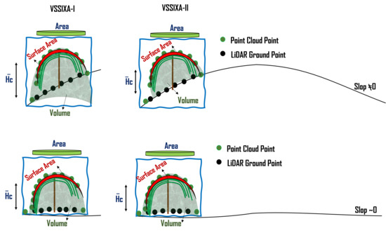
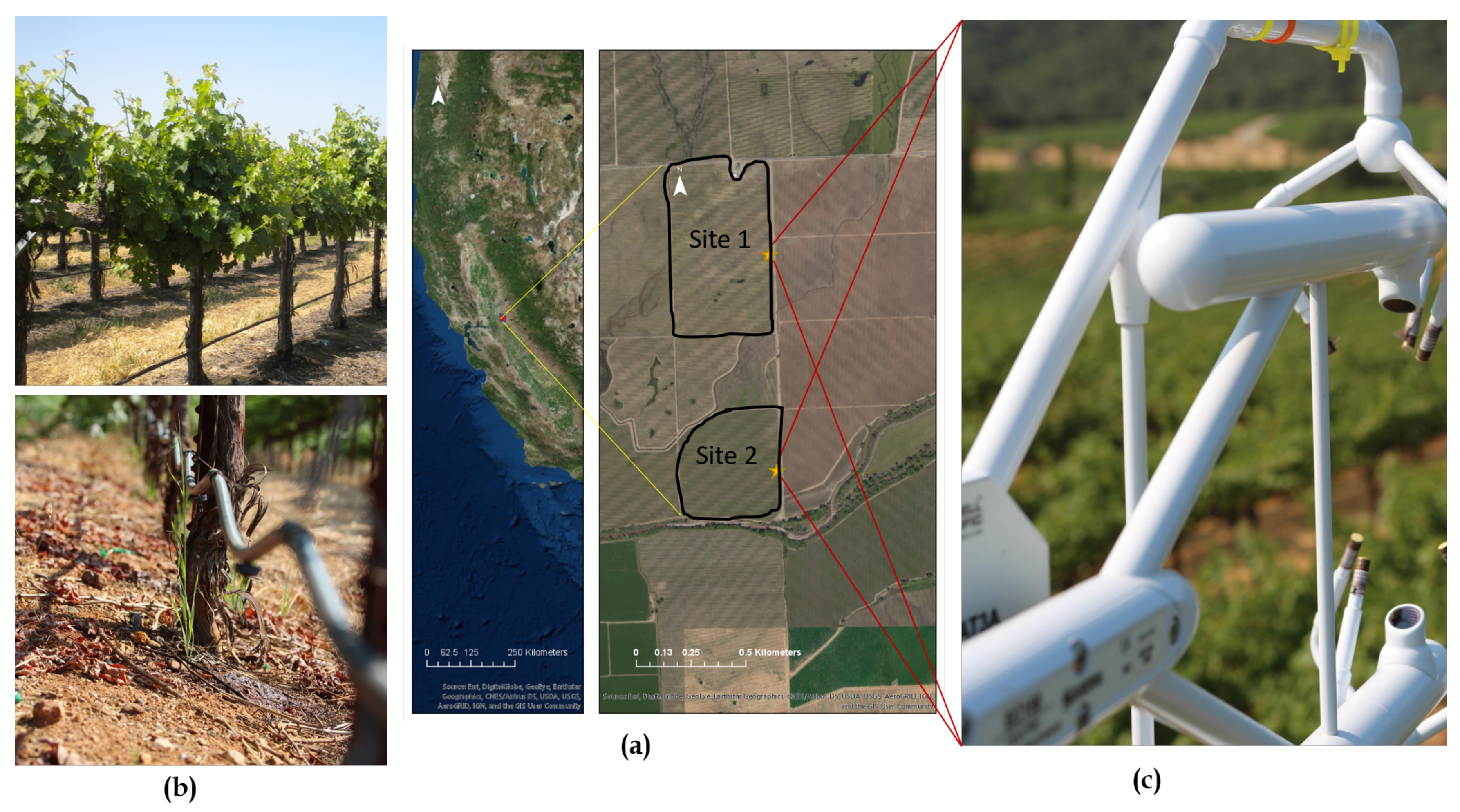
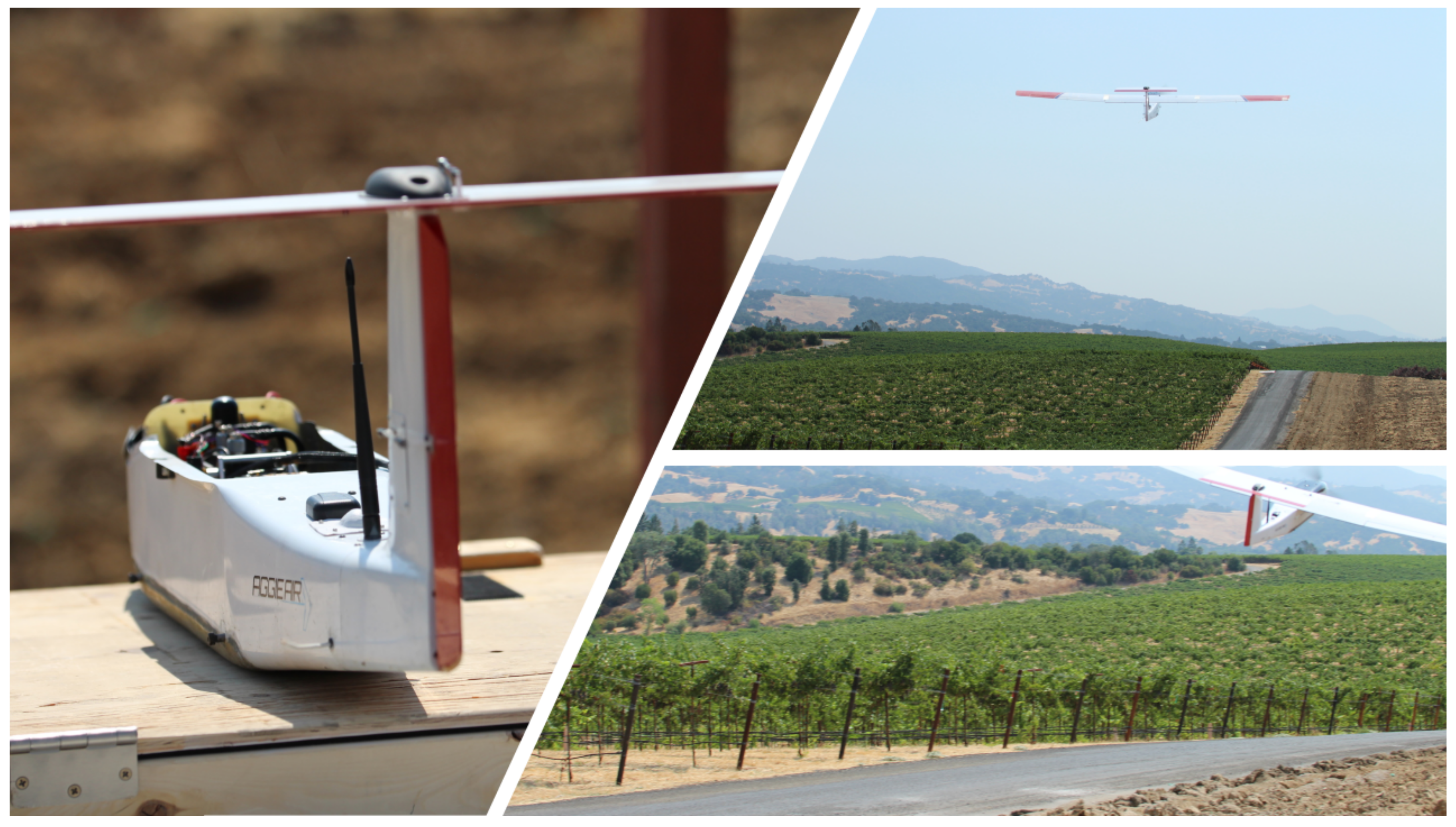
Incorporation of Unmanned Aerial Vehicle (UAV) Point Cloud Products into Remote Sensing Evapotranspiration Models

1
Department of Civil and Environmental Engineering, Utah State University, Logan, UT 84322, USA
2
U. S. Department of Agriculture, Agricultural Research Service, Hydrology and Remote Sensing Laboratory, Beltsville, MD 20705, USA
3
Complutum Tecnologías de la Información Geográfica (COMPLUTIG), 28801 Madrid, Spain
4
E & J Gallo Winery Viticulture Research, Modesto, CA 95354, USA
5
Plants, Soils and Climate Department, Utah State University, Logan, UT 84322, USA
6
Department of Electrical and Computer Engineering, Utah State University, Logan, UT 84322, USA
*
Author to whom correspondence should be addressed.
Current address: Utah Water Research Laboratory—1600 Canyon Road, Logan, UT 84321, USA.
Remote Sens. 2020, 12(1), 50; https://doi.org/10.3390/rs12010050
Submission received: 21 September 2019 / Revised: 4 December 2019 / Accepted: 6 December 2019 / Published: 20 December 2019
(This article belongs to the Special Issue 3D Point Clouds for Agriculture Applications)

Abstract

In recent years, the deployment of satellites and unmanned aerial vehicles (UAVs) has led to production of enormous amounts of data and to novel data processing and analysis techniques for monitoring crop conditions. One overlooked data source amid these efforts, however, is incorporation of 3D information derived from multi-spectral imagery and photogrammetry algorithms into crop monitoring algorithms. Few studies and algorithms have taken advantage of 3D UAV information in monitoring and assessment of plant conditions. In this study, different aspects of UAV point cloud information for enhancing remote sensing evapotranspiration (ET) models, particularly the Two-Source Energy Balance Model (TSEB), over a commercial vineyard located in California are presented. Toward this end, an innovative algorithm called Vegetation Structural-Spectral Information eXtraction Algorithm (VSSIXA) has been developed. This algorithm is able to accurately estimate height, volume, surface area, and projected surface area of the plant canopy solely based on point cloud information. In addition to biomass information, it can add multi-spectral UAV information to point clouds and provide spectral-structural canopy properties. The biomass information is used to assess its relationship with in situ Leaf Area Index (LAI), which is a crucial input for ET models. In addition, instead of using nominal field values of plant parameters, spatial information of fractional cover, canopy height, and canopy width are input to the TSEB model. Therefore, the two main objectives for incorporating point cloud information into remote sensing ET models for this study are to (1) evaluate the possible improvement in the estimation of LAI and biomass parameters from point cloud information in order to create robust LAI maps at the model resolution and (2) assess the sensitivity of the TSEB model to using average/nominal values versus spatially-distributed canopy fractional cover, height, and width information derived from point cloud data. The proposed algorithm is tested on imagery from the Utah State University AggieAir sUAS Program as part of the ARS-USDA GRAPEX Project (Grape Remote sensing Atmospheric Profile and Evapotranspiration eXperiment) collected since 2014 over multiple vineyards located in California. The results indicate a robust relationship between in situ LAI measurements and estimated biomass parameters from the point cloud data, and improvement in the agreement between TSEB model output of ET with tower measurements when employing LAI and spatially-distributed canopy structure parameters derived from the point cloud data.
Keywords: point-cloud; TSEB; LAI; evapotranspiration (ET); GRAPEX; AggieAir; UAS; UAV; VSSIXA point-cloud; TSEB; LAI; evapotranspiration (ET); GRAPEX; AggieAir; UAS; UAV; VSSIXA
Graphical Abstract

