Combined Study of a Significant Mine Collapse Based on Seismological and Geodetic Data—29 January 2019, Rudna Mine, Poland

 , ,
, ,  ,
,  , and
, and
Abstract
1. Introduction
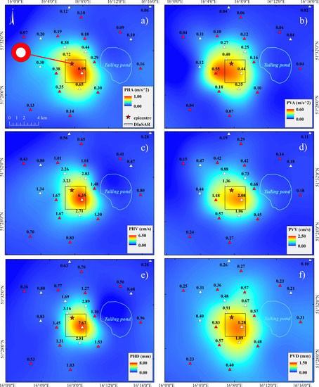
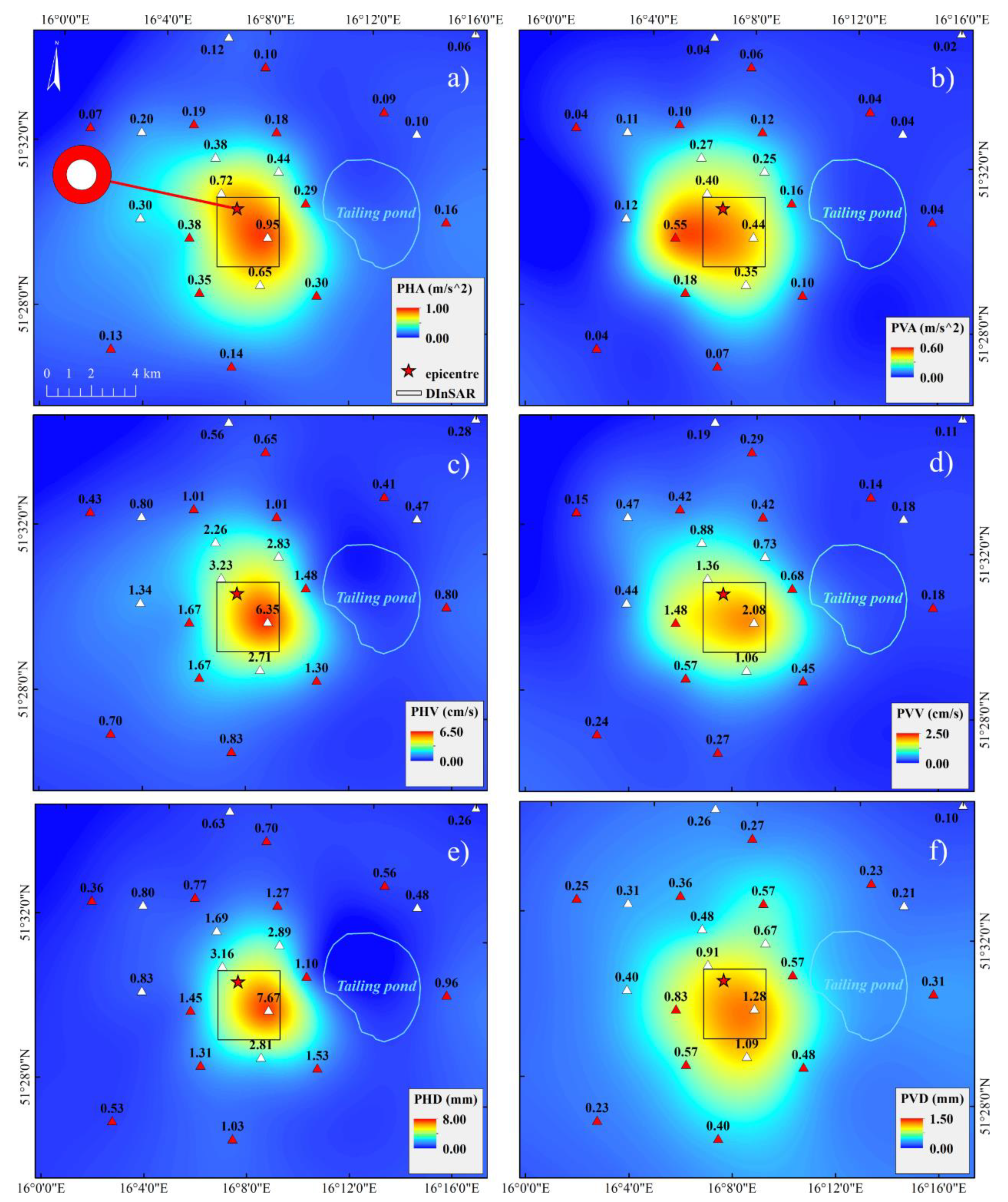
2. The Collapse and Seismological Analyses
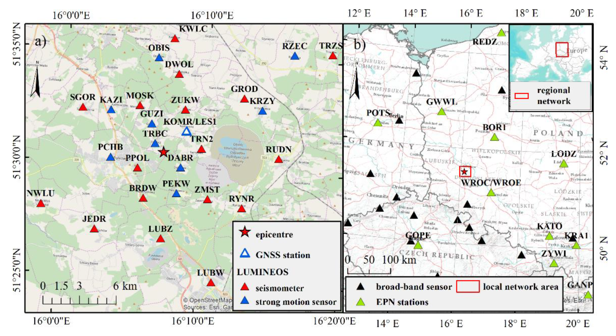
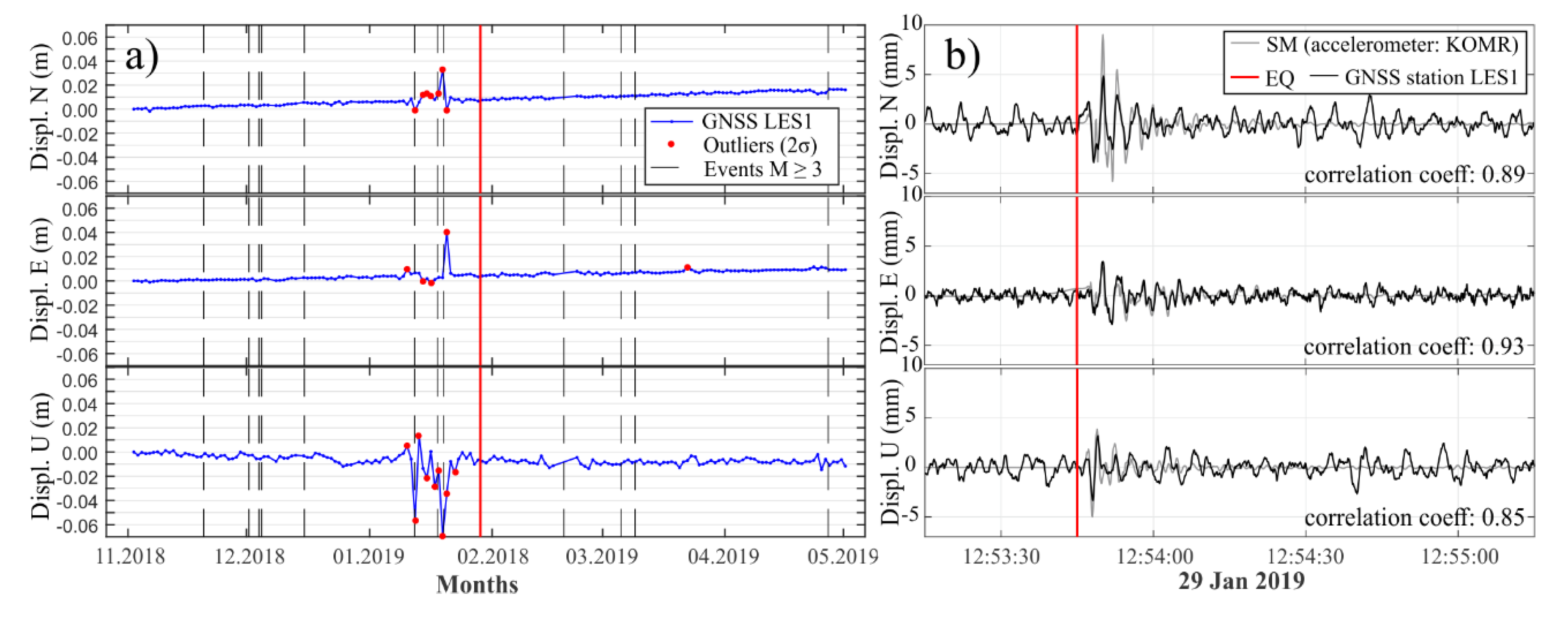
3. GNSS Short- and Long-Term Monitoring
3.1. Long-Term Monitoring
3.2. Short-Term Monitoring
4. InSAR Data and Analyses
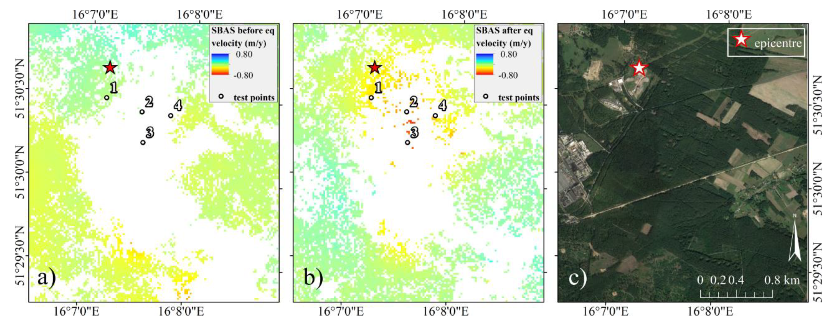
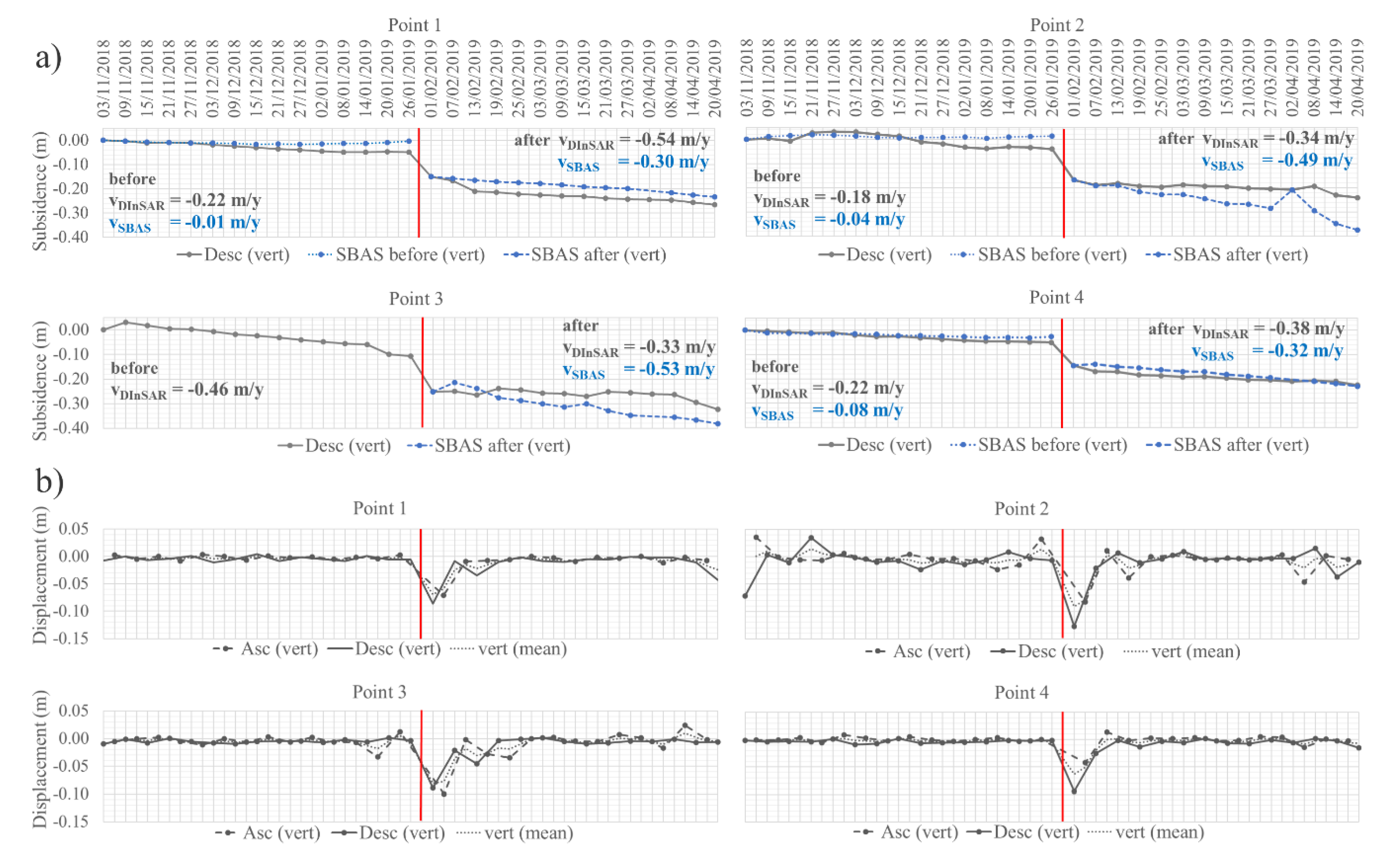
4.1. Slow-Rate Motion Monitoring with SBAS
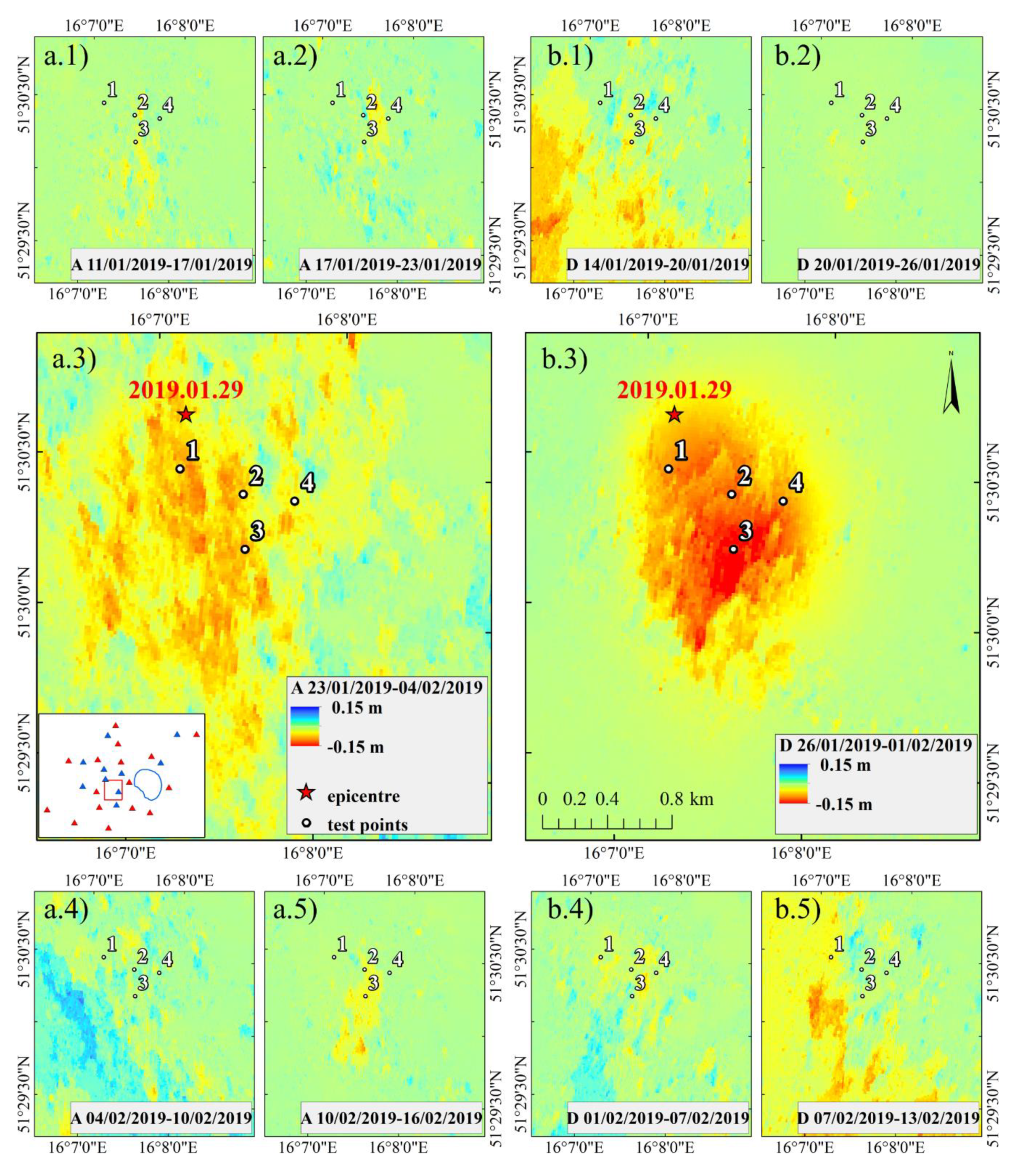
4.2. Earthquake Surface Deformation Detected by DInSAR
4.3. InSAR Time Series
5. Discussion and Conclusions
Supplementary Materials
Author Contributions
Funding
Acknowledgments
Conflicts of Interest
References
- Dreger, D.S.; Ford, S.R.; Walter, W.R. Source analysis of the Crandall Canyon, Utah, mine collapse. Science 2008, 321, 217. [Google Scholar] [CrossRef] [PubMed]
- Ford, S.R.; Dreger, D.S.; Walter, W.R. Source characterization of the 6 August 2007 Crandall canyon mine seismic event in central Utah. Seismol. Res. Lett. 2008, 79, 637–644. [Google Scholar] [CrossRef]
- Ford, S.R.; Dreger, D.S.; Walter, W.R. Identifying isotropic events using a regional moment tensor inversion. J. Geophys. Res. Solid Earth 2009, 114. [Google Scholar] [CrossRef]
- Rudzinski, Ł.; Cesca, S.; Lizurek, G. Complex rupture process of the 19 March 2013, Rudna mine (Poland) induced seismic event and collapse in the light of local and regional moment tensor inversion. Seismol. Res. Lett. 2016, 87, 274–284. [Google Scholar] [CrossRef]
- Klose, C.D. Geomechanical modeling of the nucleation process of Australia’s 1989 M5.6 Newcastle earthquake. Earth Planet. Sci. Lett. 2007, 256, 547–553. [Google Scholar] [CrossRef]
- McGarr, A.; Simpson, D.; Seeber, L. Case histories of induced and triggered seismicity. In IInternational Geophysics Series, International Handbook of Earthquake and Engineering Seismology; Academic Press: Cambridge, MA, USA, 2002; Volume 81A, pp. 647–661. ISBN 0124406521. [Google Scholar]
- Mirek, K.; Mirek, J. Non-parametric approximation used to analysis of psinsarTM data of upper silesian coal basin, Poland. Acta Geodyn. Geomater. 2009, 6, 405–409. [Google Scholar]
- Mirek, K.; Mirek, J. Observation of underground exploitation influence on a surface in Budryk, Sośnica, and Makoszowy Coal Mine Area. Pol. J. Environ. Stud. 2016, 25, 57–61. [Google Scholar]
- Zheng, M.; Deng, K.; Fan, H.; Du, S. Monitoring and analysis of surface deformation in mining area based on InSAR and GRACE. Remote Sens. 2018, 10, 1392. [Google Scholar] [CrossRef]
- Malinowska, A.A.; Witkowski, W.T.; Guzy, A.; Hejmanowski, R. Mapping ground movements caused by mining-induced earthquakes applying satellite radar interferometry. Eng. Geol. 2018, 246, 402–411. [Google Scholar] [CrossRef]
- Rudziński, Ł.; Mirek, K.; Mirek, J. Rapid ground deformation corresponding to a mining-induced seismic event followed by a massive collapse. Nat. Hazards 2019, 96, 461–471. [Google Scholar] [CrossRef]
- Rudziński, Ł.; Cesca, S.; Talaga, A.; Koziarz, E. Complex mechanism of rockburst observed on Polish copper mines. In Proceedings of the 9th International Symposium on Rockbursts and Seismicity in Mines—RaSiM9, Santiago, Chile, 15–17 November 2017; Vallejos, J.A., Ed.; University of Chile: Santiago, Chile, 2017; pp. 87–92. [Google Scholar]
- Milczarek, W. Investigation of post inducted seismic deformation of the 2016 Mw4.2 Tarnowek Poland mining tremor based on DInSAR and SBAS methods. Acta Geodyn. Geomater. 2019, 16, 183–193. [Google Scholar] [CrossRef]
- Dec, J.; Pietsch, K.; Marzec, P. Application of seismic methods to identify potential gas concentration zones at the Zechstein Limestone Level in the “Rudna” mining area, SW Poland. Ann. Soc. Geol. Pol. 2011, 81, 63–78. [Google Scholar]
- Orfeus: European Integrated Data Archive. Available online: http://www.orfeus-eu.org/data/eida/ (accessed on 8 August 2019).
- Hasegawa, H.S.; Wetmiller, R.J.; Gendzwill, D.J. Induced seismicity in mines in Canada—An overview. Pure Appl. Geophys. 1989, 129, 423–453. [Google Scholar] [CrossRef]
- Heimann, S.; Kriegerowski, M.; Isken, M.; Cesca, S.; Daout, S.; Grigoli, F.; Juretzek, C.; Megies, T.; Nooshiri, N.; Steinberg, A.; et al. Pyrocko—An Open-Source Seismology Toolbox and Library. V. 0.3; GFZ: Potsdam, Germany, 2017. [Google Scholar]
- Heimann, S. A Robust Method to Estimate Kinematic Earthquake Source Parameters. Ph.D. Thesis, University of Hamburg, Hamburg, Germany, 2011. [Google Scholar]
- Sen, A.T.; Cesca, S.; Bischoff, M.; Meier, T.; Dahm, T. Automated full moment tensor inversion of coal mining-induced seismicity. Geophys. J. Int. 2013, 195, 1267–1281. [Google Scholar] [CrossRef]
- Grad, M.; Jensen, S.L.; Keller, G.R.; Guterch, A.; Thybo, H.; Janik, T.; Tiira, T.; Yliniemi, J.; Luosto, U.; Motuza, G.; et al. Crustal structure of the Trans-European suture zone region along POLONAISE’97 seismic profile P4. J. Geophys. Res. 2003, 108, 2541. [Google Scholar] [CrossRef]
- Jost, M.L.; Herrmann, R.B. A Student’s Guide to and Review of Moment Tensors. Seismol. Res. Lett. 1989, 60, 37–57. [Google Scholar] [CrossRef]
- Talebi, S.; Coté, M. Implosional Focal Mechanisms in a Hard-Rock Mine. In Proceedings of the Controlling Seismic Risk, 6th International Symposium on Rockburst and Seismicity in Mines, Perth, Australia, 9–11 March 2005; Potvin, Y., Hudyma, M., Eds.; Australian Centre for Geomechanics: Perth, Australia, 2005; pp. 113–121. [Google Scholar]
- Hu, H.; Gao, J.; Yao, Y. Land deformation monitoring in mining area with PPP-AR. Int. J. Min. Sci. Technol. 2014, 24, 207–212. [Google Scholar] [CrossRef]
- Bian, H.F.; Zhang, S.B.; Zhang, Q.Z.; Zheng, N.S. Monitoring large-area mining subsidence by GNSS based on IGS stations. Trans. Nonferrous Met. Soc. China 2014, 24, 514–519. [Google Scholar] [CrossRef]
- Üstün, A.; Tuşat, E.; Yalvaç, S.; Özkan, İ.; Eren, Y.; Özdemir, A.; Bildirici, Ö.; Üstüntaş, T.; Kırtıloğlu, O.S.; Mesutoğlu, M.; et al. Land subsidence in Konya Closed Basin and its spatio-temporal detection by GPS and DInSAR. Environ. Earth Sci. 2015, 73, 6691–6703. [Google Scholar] [CrossRef]
- Li, X.; Zheng, K.; Li, X.; Liu, G.; Ge, M.; Wickert, J.; Schuh, H. Real-time capturing of seismic waveforms using high-rate BDS, GPS and GLONASS observations: The 2017 Mw 6.5 Jiuzhaigou earthquake in China. GPS Solut. 2019, 23, 1–12. [Google Scholar] [CrossRef]
- Kudlacik, I.; Kaplon, J.; Bosy, J.; Lizurek, G. Seismic phenomena in the light of high-rate GPS precise point positioning results. Acta Geodyn. Geomater. 2019, 193, 99–112. [Google Scholar] [CrossRef]
- Michel, C.; Kelevitz, K.; Houlié, N.; Edwards, B.; Psimoulis, P.; Su, Z.; Clinton, J.; Giardini, D. The potential of high-rate GPS for strong ground motion assessment. Bull. Seismol. Soc. Am. 2017, 107, 1849–1859. [Google Scholar] [CrossRef]
- Bock, Y.; Prawirodirdjo, L.; Melbourne, T.I. Detection of arbitrarily large dynamic ground motions with a dense high-rate GPS network. Geophys. Res. Lett. 2004, 31. [Google Scholar] [CrossRef]
- Dach, R.; Lutz, S.; Walser, P.; Fridez, P. (Eds.) Bernese GNSS Software Version 5.2. User Manual; Astronomical Institute, University of Bern, Bern Open Publishing: Bern, Switzerland, 2015; ISBN 978-3-906813-05-9. [Google Scholar]
- Bruyninx, C.; Legrand, J.; Fabian, A.; Pottiaux, E. GNSS metadata and data validation in the EUREF Permanent Network. GPS Solut. 2019, 23, 106. [Google Scholar] [CrossRef]
- Herring, T.A.; King, R.W.; Floyd, M.A.; McClusky, S.C. Introduction to GAMIT/GLOBK; Release 10.8; Massachusetts Institute of Technology: Cambridge, MA, USA, 2018. [Google Scholar]
- Melbourne, W. The Case for Ranging in GPS Based Geodetic System. In Proceedings of the 1st International Symposium on Precise Positioning with the Global Positioning System, Rockville, MD, USA, 15–19 April 1985; Goad, C., Ed.; U.S. Department of Commerce: Rockville, MD, USA, 1985. [Google Scholar]
- Wübbena, G. Software Developments for Geodetic Positioning with GPS Using TI 4100 Code and Carrier Measurements. In Proceedings of the 1st International Symposium on Precise Positioning with the Global Positioning System, Rockville, MD, USA, 15–19 April 1985; Goad, C., Ed.; U.S. Department of Commerce: Rockville, MD, USA, 1985; pp. 403–412. [Google Scholar]
- Orús, R.; Hernández-Pajares, M.; Juan, J.M.; Sanz, J. Improvement of global ionospheric VTEC maps by using kriging interpolation technique. J. Atmos. Solar Terr. Phys. 2005, 67, 1598–1609. [Google Scholar] [CrossRef]
- Berardino, P.; Fornaro, G.; Lanari, R.; Sansosti, E. A new algorithm for surface deformation monitoring based on small baseline differential SAR interferograms. IEEE Trans. Geosci. Remote Sens. 2002, 40, 2375–2383. [Google Scholar] [CrossRef]
- Massonnet, D.; Rossi, M.; Carmona, C.; Adragna, F.; Peltzer, G.; Feigl, K.; Rabaute, T. The displacement field of the Landers earthquake mapped by radar interferometry. Nature 1993, 364, 138–142. [Google Scholar] [CrossRef]
- Chen, C.W.; Zebker, H.A. Network approaches to two-dimensional phase unwrapping: Intractability and two new algorithms. J. Opt. Soc. Am. A 2000, 17, 401–414. [Google Scholar] [CrossRef]
- Rodriguez, E.; Morris, C.S.; Belz, J.E.; Chapin, E.C.; Martin, J.M.; Daffer, W.; Hensley, S. An Assessment of the SRTM Topographic Products, Technical Report JPL D-31639; Jet Propulsion Laboratory: Pasadena, CA, USA, 2005. [Google Scholar]
- Crosetto, M.; Monserrat, O.; Cuevas-González, M.; Devanthéry, N.; Crippa, B. Persistent Scatterer Interferometry: A review. ISPRS J. Photogramm. Remote Sens. 2016, 115, 78–89. [Google Scholar] [CrossRef]
- L3Harris Geospatial ENVI® SARscape®. Available online: https://www.harrisgeospatial.com/Software-Technology/ENVI-SARscape (accessed on 8 May 2020).
- ESA SNAP Sentinel-1 Toolbox. Available online: https://step.esa.int/main/toolboxes/sentinel-1-toolbox/ (accessed on 8 May 2020).
- Hooper, A.; Bekaert, D.; Spaans, K.; Arikan, M. Recent advances in SAR interferometry time series analysis for measuring crustal deformation. Tectonophysics 2012, 514–517, 1–13. [Google Scholar] [CrossRef]
- Pawluszek-Filipiak, K.; Borkowski, A. Integration of DInSAR and SBAS techniques to determine mining-related deformations using Sentinel-1 data: The case study of Rydultowy mine in Poland. Remote Sens. 2020, 12, 242. [Google Scholar] [CrossRef]
- Ilieva, M.; Polanin, P.; Borkowski, A.; Gruchlik, P.; Smolak, K.; Kowalski, A.; Rohm, W. Mining Deformation Life Cycle in the Light of InSAR and Deformation Models. Remote Sens. 2019, 11, 745. [Google Scholar] [CrossRef]
- Klein, E.; Contrucci, I.; Daupley, X.; Hernandez, O.; Nadim, C.; Cauvin, L.; Pirson, M.; Klein, E.; Contrucci, I.; Daupley, X.; et al. Evolution monitoring of a solution-mining cavern in salt: Identifying and analysing early-warning signals prior to collapse. In Proceedings of the SMRI Fall Technical Conference, Austin, TX, USA, 12–14 October 2008; pp. 1–12. [Google Scholar]
- Klein, E.; Contrucci, I.; Cao, N.T.; Bigarre, P. Mining induced seismicity—Monitoring of a large scale salt cavern collapse. In Proceedings of the 73rd European Association of Geoscientists and Engineers Conference and Exhibition 2011: Unconventional Resources and the Role of Technology. Incorporating SPE EUROPEC 2011, Vienna, Austria, 23–26 May 2011; pp. 615–619. [Google Scholar]
- Contrucci, I.; Klein, E.; Cao, N.-T.; Daupley, X.; Bigarré, P. Multi-parameter monitoring of a solution mining cavern collapse: First insight of precursors. Comptes Rendus Geosci. 2011, 343, 1–10. [Google Scholar] [CrossRef]
- Ćwiękała, M. Korelacja wyników monitoringu geodezyjnego z sejsmicznością indukowaną w czasie eksploatacji ściany VIb-E1 w pokładzie 703/1 w KWK ROW Ruch Rydułtowy Correlation of geodetic monitoring results with seismicity induced by exploitation of longwall VIb-E1 in. Przegląd Górniczy 2019, 75, 4–15. [Google Scholar]
- Krawczyk, A.; Grzybek, R. An evaluation of processing InSAR Sentinel-1A/B data for correlation of mining subsidence with mining induced tremors in the Upper Silesian Coal Basin (Poland). E3S Web Conf. 2018, 26. [Google Scholar] [CrossRef]
- Szczerbowski, Z.; Jura, J. Mining induced seismic events and surface deformations monitored by GPS permanent stations. Acta Geodyn. Geomater. 2015, 12, 237–248. [Google Scholar] [CrossRef]
- Szczerbowski, Z. High-energy seismic events in Legnica–Głogów Copper District in light of ASG-EUPOS data. Rep. Geod. Geoinform. 2019, 107, 25–40. [Google Scholar] [CrossRef]
- Wang, L.; Deng, K.; Zheng, M. Research on ground deformation monitoring method in mining areas using the probability integral model fusion D-InSAR, sub-band InSAR and offset-tracking. Int. J. Appl. Earth Obs. Geoinf. 2020, 85, 101981. [Google Scholar] [CrossRef]
- Milczarek, W. Application of a Small Baseline Subset Time Series Method with Atmospheric Correction in Monitoring Results of Mining Activity on Ground Surface and in Detecting Induced Seismic Events. Remote Sens. 2019, 11, 1008. [Google Scholar] [CrossRef]
- Psimoulis, P.; Houlié, N.; Meindl, M.; Rothacher, M. Consistency of PPP GPS and strong-motion records: Case study of Mw9.0 Tohoku-Oki 2011 earthquake. Smart Struct. Syst. 2015, 16, 347–366. [Google Scholar] [CrossRef]
- Nie, Z.; Zhang, R.; Liu, G.; Jia, Z.; Wang, D.; Zhou, Y.; Lin, M. GNSS seismometer: Seismic phase recognition of real-time high-rate GNSS deformation waves. J. Appl. Geophys. 2016, 135, 328–337. [Google Scholar] [CrossRef]
- Fratarcangeli, F.; Savastano, G.; D’Achille, M.C.; Mazzoni, A.; Crespi, M.; Riguzzi, F.; Devoti, R.; Pietrantonio, G. VADASE reliability and accuracy of real-time displacement estimation: Application to the Central Italy 2016 earthquakes. Remote Sens. 2018, 10, 1201. [Google Scholar] [CrossRef]
- Xu, C.; Gong, Z.; Niu, J. Recent developments in seismological geodesy. Geod. Geodyn. 2016, 7, 157–164. [Google Scholar] [CrossRef]
- Orlecka-Sikora, B.; Lasocki, S.; Kocot, J.; Szepieniec, T.; Robert Grasso, J.; Garcia-aristizabal, A.; Schaming, M.; Urban, P.; Jones, G.; Stimpson, I.; et al. An open data infrastructure for the study of anthropogenic hazards linked to georesource exploitation. Sci. Data 2020, 7, 1–16. [Google Scholar] [CrossRef] [PubMed]


© 2020 by the authors. Licensee MDPI, Basel, Switzerland. This article is an open access article distributed under the terms and conditions of the Creative Commons Attribution (CC BY) license (http://creativecommons.org/licenses/by/4.0/).
Share and Cite
Ilieva, M.; Rudziński, Ł.; Pawłuszek-Filipiak, K.; Lizurek, G.; Kudłacik, I.; Tondaś, D.; Olszewska, D. Combined Study of a Significant Mine Collapse Based on Seismological and Geodetic Data—29 January 2019, Rudna Mine, Poland. Remote Sens. 2020, 12, 1570. https://doi.org/10.3390/rs12101570
Ilieva M, Rudziński Ł, Pawłuszek-Filipiak K, Lizurek G, Kudłacik I, Tondaś D, Olszewska D. Combined Study of a Significant Mine Collapse Based on Seismological and Geodetic Data—29 January 2019, Rudna Mine, Poland. Remote Sensing. 2020; 12(10):1570. https://doi.org/10.3390/rs12101570
Chicago/Turabian StyleIlieva, Maya, Łukasz Rudziński, Kamila Pawłuszek-Filipiak, Grzegorz Lizurek, Iwona Kudłacik, Damian Tondaś, and Dorota Olszewska. 2020. "Combined Study of a Significant Mine Collapse Based on Seismological and Geodetic Data—29 January 2019, Rudna Mine, Poland" Remote Sensing 12, no. 10: 1570. https://doi.org/10.3390/rs12101570
APA StyleIlieva, M., Rudziński, Ł., Pawłuszek-Filipiak, K., Lizurek, G., Kudłacik, I., Tondaś, D., & Olszewska, D. (2020). Combined Study of a Significant Mine Collapse Based on Seismological and Geodetic Data—29 January 2019, Rudna Mine, Poland. Remote Sensing, 12(10), 1570. https://doi.org/10.3390/rs12101570