Spatiotemporal Patterns of COVID-19 Impact on Human Activities and Environment in Mainland China Using Nighttime Light and Air Quality Data

 , , ,
, , , 
Abstract
:
1. Introduction
2. Materials and Methods
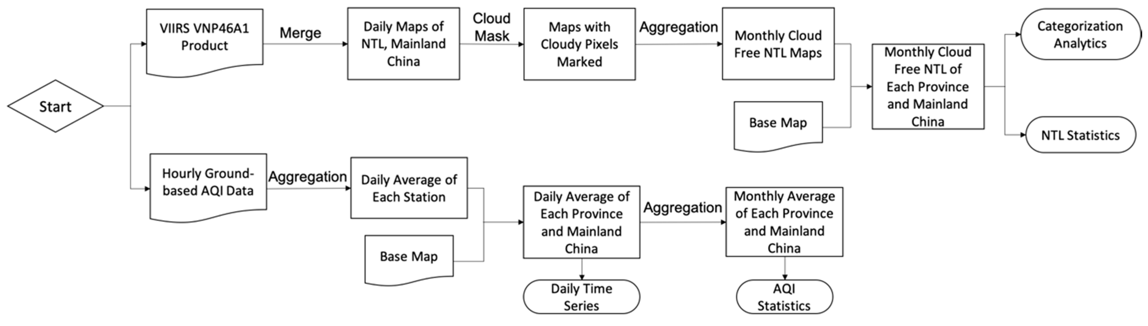
2.1. Dataset
2.2. Data Preprocessing
2.2.1. NPP/VIIRS NTL Data
2.2.2. AQI Data
2.3. NTL Radiance Categorization
2.4. Workflow
3. Results
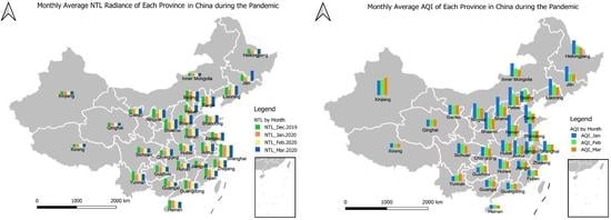
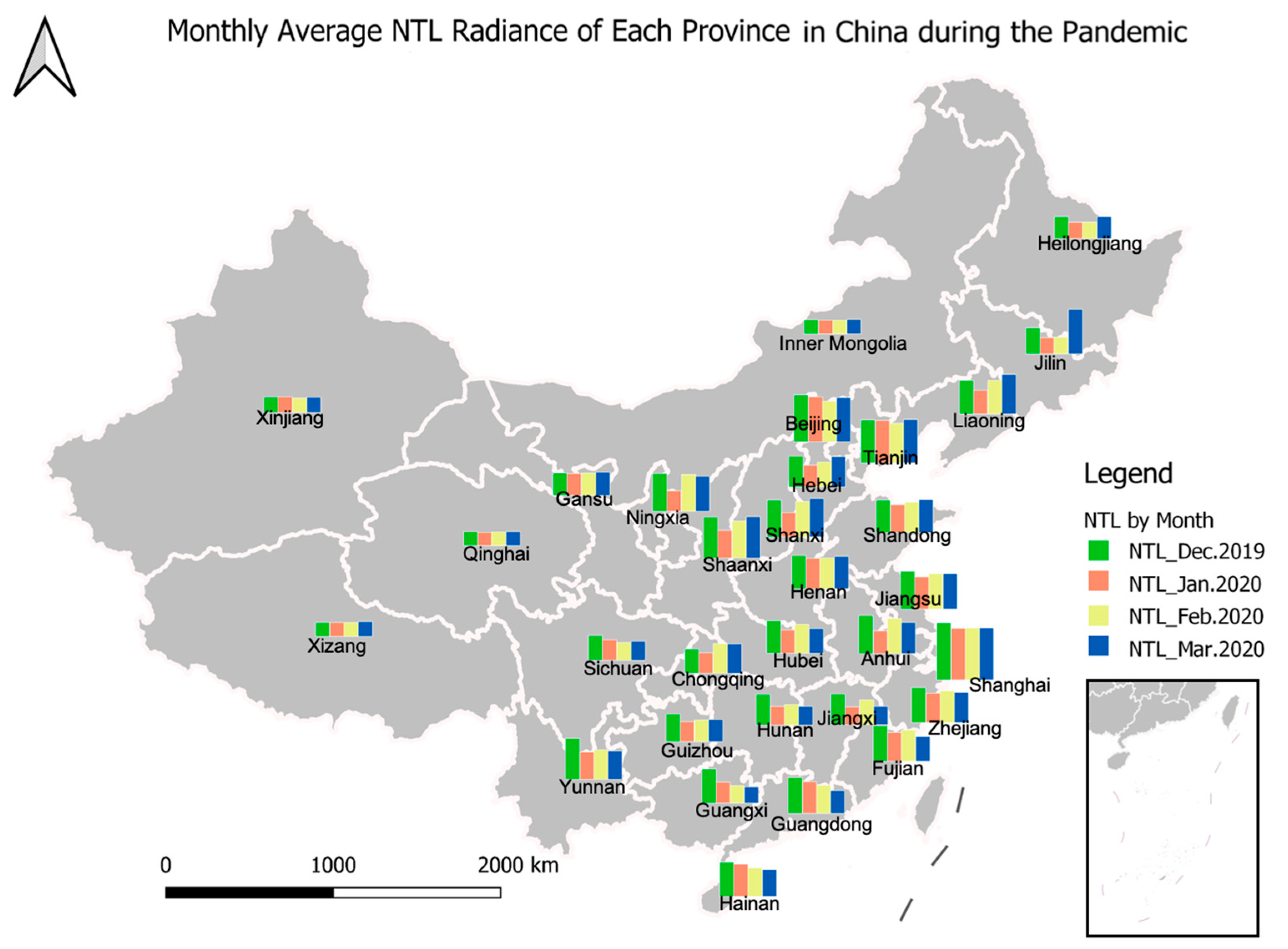
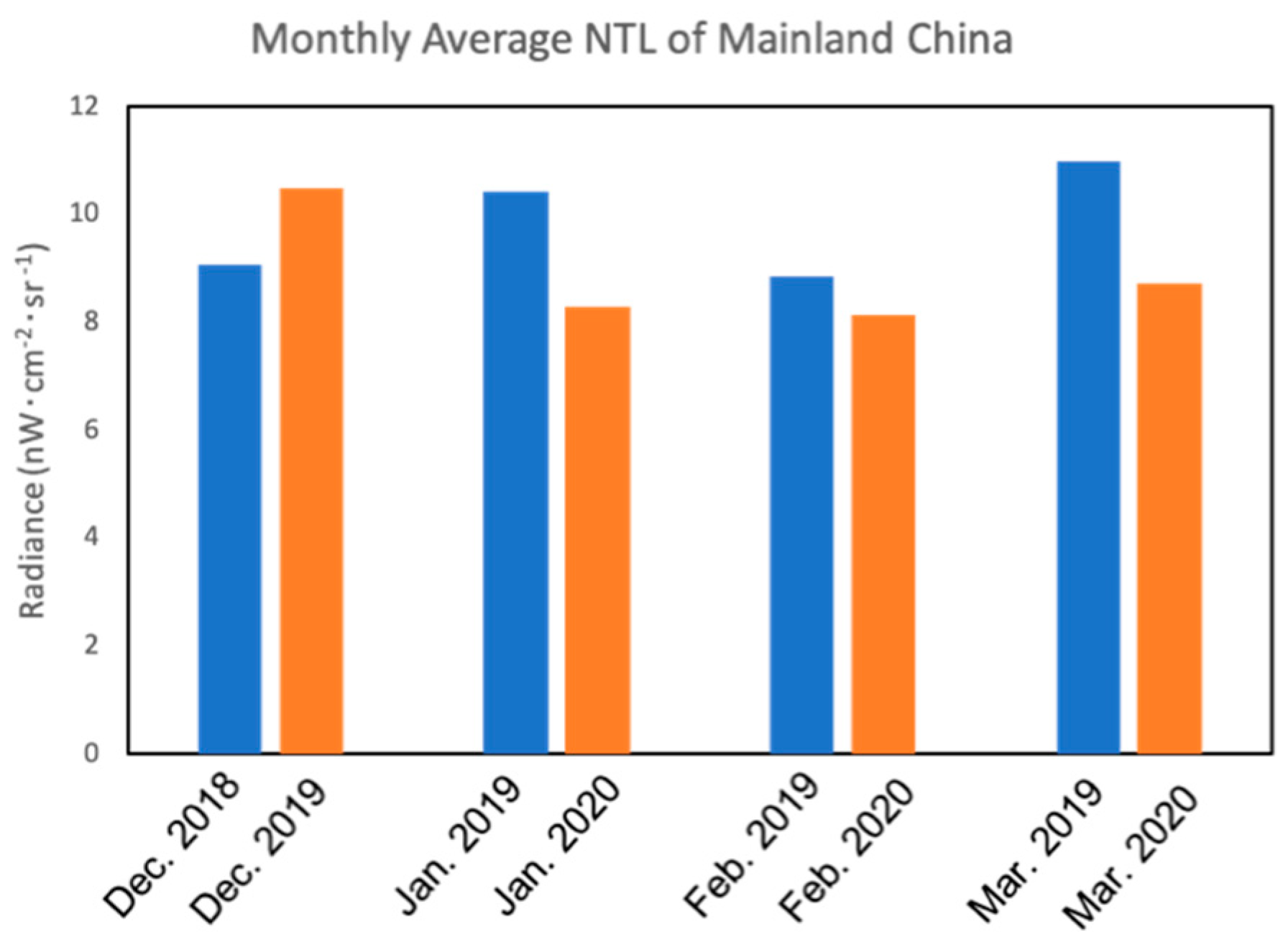
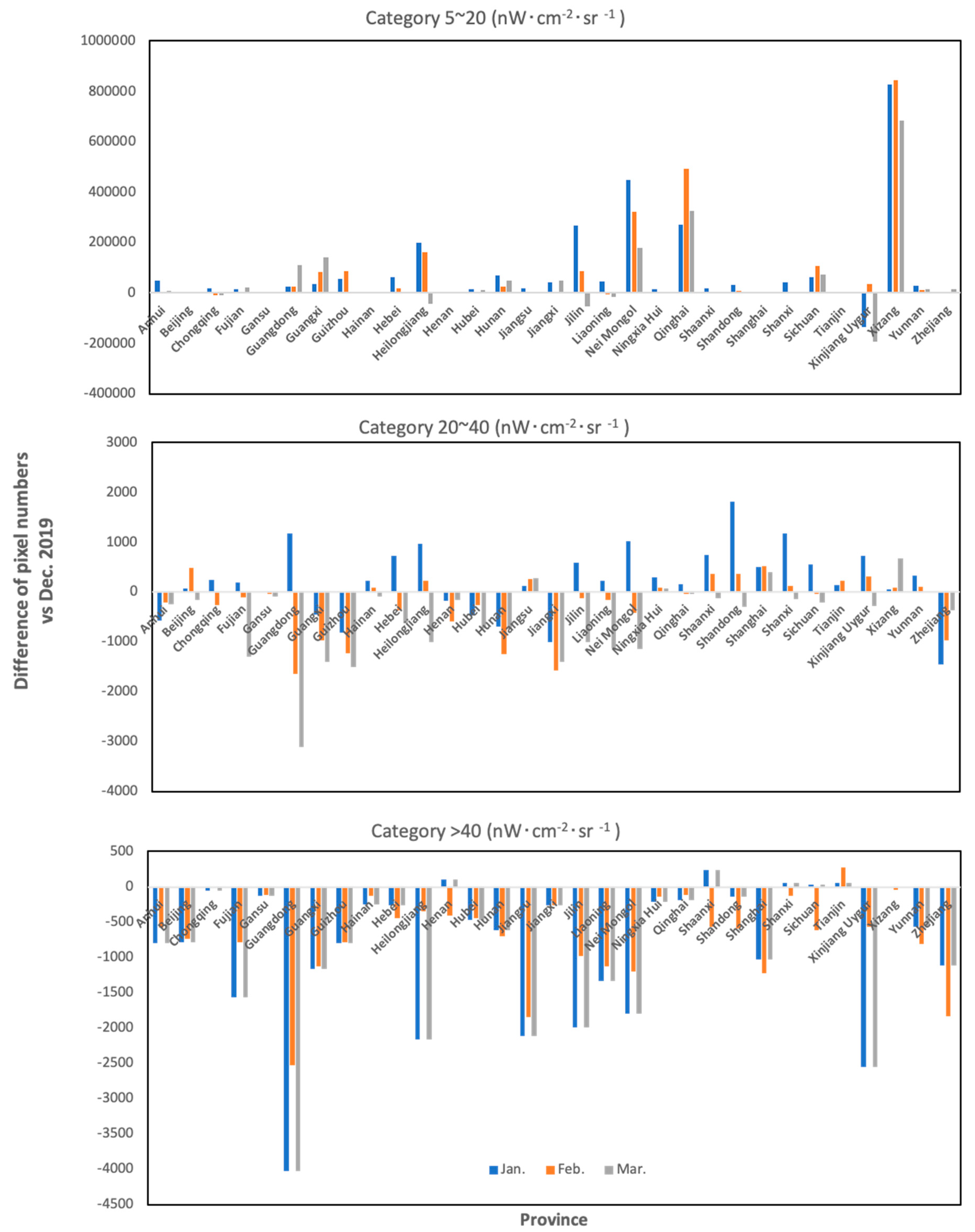
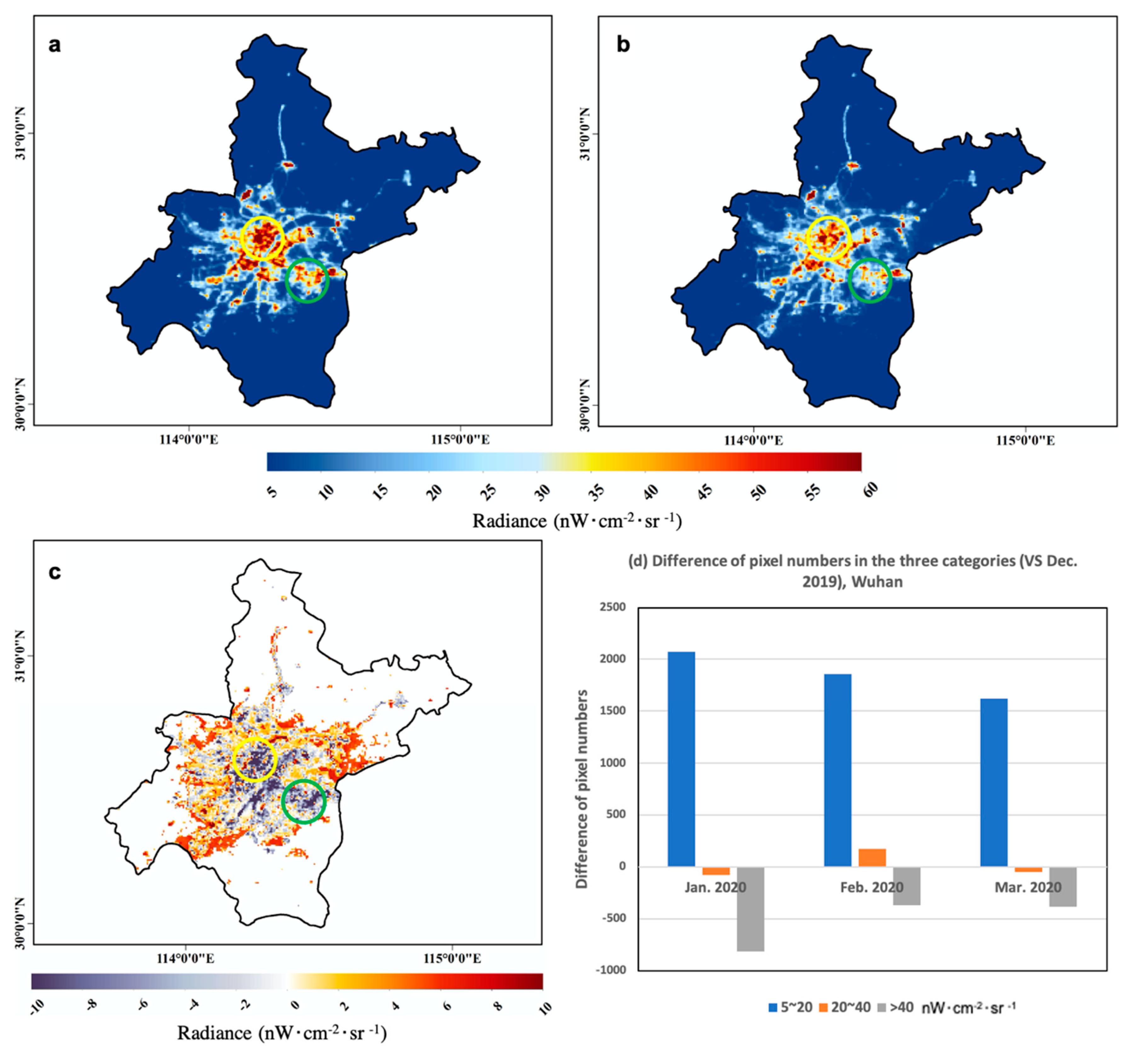
3.1. Impact of COVID-19 on Human Activity Observed by NTL
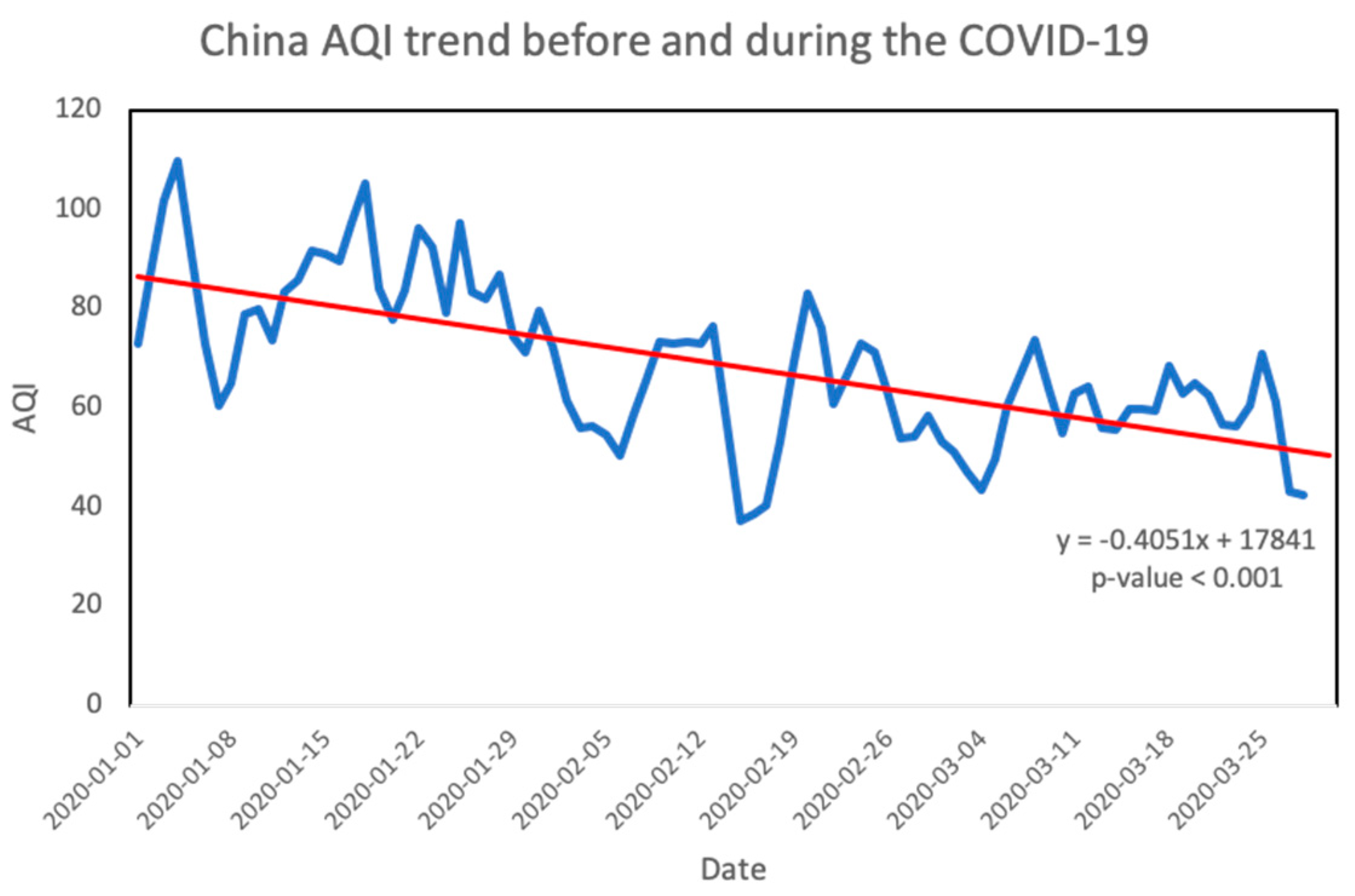
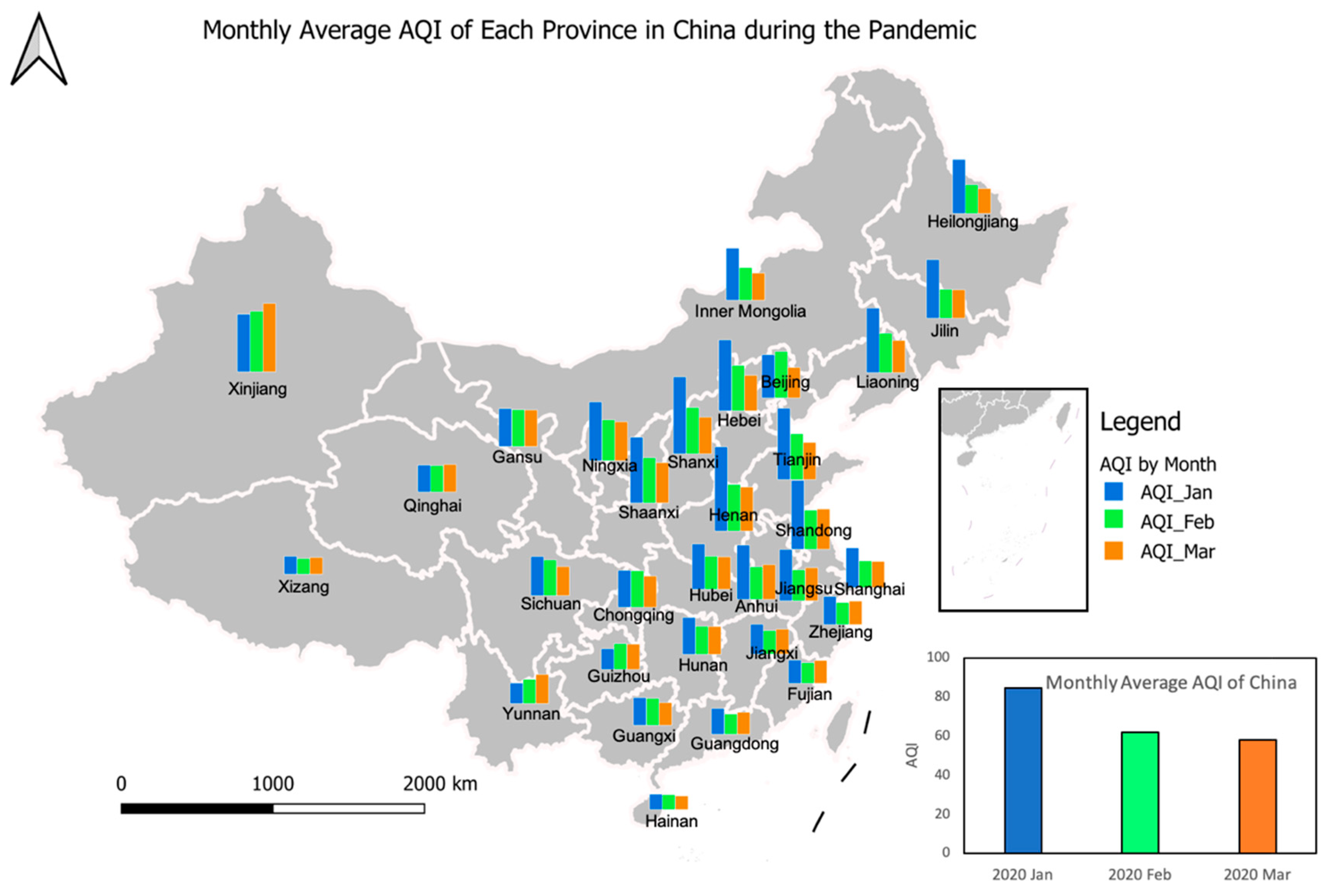
3.2. Impact of COVID-19 on Air Quality
4. Discussion
- Implement strict data quality control procedure to remove noise from the nighttime light signal;
- The socioeconomic impact of COVID-19 will be examined by monitoring the change in economic conditions such as GDP, individual income, and unemployment rate using NTL and census data;
- As some analytics and news illustrated, the infection and death rates of COVID-19 have various patterns in different communities [42]. The NTL and other high-resolution remote sensing data sources can be used to distinguish community types in terms of income levels, races, and occupations [43]. In the future, the COVID-19 spread and impact condition will be further studied in different human groups;
- The investigation on air quality will be more detailed on some specific pollutants such as SO2, CO, and Ozone that are not addressed in the previous studies;
- Since the COVID-19 has shown its effects on atmospheric conditions, will it influence the weather, or even the climate, if it cannot be controlled in a short time? Further research is needed on the impact of COVID-19 by modeling with more climatic and virus-spread factors [44].
5. Conclusions
- The average NTL radiance decreases in most provinces and the entire country of mainland China with the implementation of shutdown policies. Some exceptions are shown in several provinces due to their small number of confirmed cases, quarantine policies, and low original NTL brightness;
- Impacting by the lockdown and quarantine policies, the NTL radiance is lower in the first three months of 2020 than 2019;
- The number of detected NTL pixels increases in the residential areas while it decreases in the commercial center regions, and generally stays the same in the transportation and public facilities during the studied pandemic time period. This reflects a transfer of human activities from shopping and entertainment centers to residential areas due to the quarantine policies;
- The total air quality improved during the COVID-19 crisis because of the reduction in industrial production and vehicle usage;
- The spread of COVID-19 and related policies have a significant impact on people’s daily lives and the environment.
Author Contributions
Funding
Acknowledgments
Conflicts of Interest
References
- Yang, C.; Sha, D.; Liu, Q.; Li, Y.; Lan, H.; Guan, W.W.; Hu, T.; Li, Z.; Zhang, Z.; Thompson, J.H.; et al. Taking the pulse of COVID-19: A spatiotemporal perspective. arXiv 2020, arXiv:2005.04224v1. [Google Scholar]
- Wang, J.; Tang, K.; Feng, K.; Lv, W. High Temperature and High Humidity Reduce the Transmission of Covid-19. 2020. Available online: https://ssrn.com/abstract=3551767 (accessed on 8 April 2020).
- Ma, Y.; Zhao, Y.; Liu, J.; He, X.; Wang, B.; Fu, S.; Yan, J.; Niu, J.; Zhou, J.; Luo, B. Effects of temperature variation and humidity on the death of COVID-19 in Wuhan, China. Sci. Total Environ. 2020. [Google Scholar] [CrossRef]
- Luo, W.; Majumder, M.; Liu, D.; Poirier, C.; Mandl, K.; Lipsitch, M.; Santillana, M. The role of absolute humidity on transmission rates of the COVID-19 outbreak. medRxiv 2020. [Google Scholar] [CrossRef]
- Oliveiros, B.; Caramelo, L.; Ferreira, N.C.; Caramelo, F. Role of temperature and humidity in the modulation of the doubling time of COVID-19 cases. medRxiv 2020. [Google Scholar] [CrossRef] [Green Version]
- Jia, J.; Ding, J.; Liu, S.; Liao, G.; Li, J.; Duan, B.; Wang, G.; Zhang, R. Modeling the control of covid-19: Impact of policy interventions and meteorological factors. arXiv 2020, arXiv:2003.02985. [Google Scholar]
- Sajadi, M.M.; Habibzadeh, P.; Vintzileos, A.; Shokouhi, S.; Miralles-Wilhelm, F.; Amoroso, A. Temperature and latitude analysis to predict potential spread and seasonality for COVID-19. 2020. Available online: https://ssrn.com/abstract=3550308 (accessed on 8 April 2020).
- Buckee, C.O.; Balsari, S.; Chan, J.; Crosas, M.; Dominici, F.; Gasser, U.; Grad, Y.H.; Grenfell, B.; Halloran, M.E.; Kraemer, M.U.; et al. Aggregated mobility data could help fight COVID-19. Science (N. Y.) 2020, 368, 145. [Google Scholar] [CrossRef] [Green Version]
- Kraemer, M.U.; Yang, C.H.; Gutierrez, B.; Wu, C.H.; Klein, B.; Pigott, D.M.; du Plessis, L.; Faria, N.R.; Li, R.; Hanage, W.P.; et al. The effect of human mobility and control measures on the COVID-19 epidemic in China. Science 2020, 368, 493–497. [Google Scholar] [CrossRef] [Green Version]
- Cao, C.; Chang, C.; Xu, M.; Zhao, J.; Gao, M.; Zhang, H.; Guo, J.; Guo, J.; Dong, L.; He, Q.; et al. Epidemic risk analysis after the Wenchuan Earthquake using remote sensing. Int. J. Remote Sens. 2010, 31, 3631–3642. [Google Scholar] [CrossRef]
- Xu, H.; Yu, T.; Gu, X.F.; Cheng, T.H.; Xie, D.H.; Liu, Q. The research on remote sensing dust aerosol by using split window emissivity. Spectrosc. Spectr. Anal. 2013, 33, 1189–1193. [Google Scholar]
- Liu, Q.; Li, Y.; Yu, M.; Chiu, L.S.; Hao, X.; Duffy, D.Q.; Yang, C. Daytime Rainy Cloud Detection and Convective Precipitation Delineation Based on a Deep Neural Network Method Using GOES-16 ABI Images. Remote Sens. 2019, 11, 2555. [Google Scholar] [CrossRef] [Green Version]
- Yang, C.; Yu, M.; Li, Y.; Hu, F.; Jiang, Y.; Liu, Q.; Sha, D.; Xu, M.; Gu, J. Big Earth data analytics: A survey. Big Earth Data 2019, 3, 83–107. [Google Scholar] [CrossRef] [Green Version]
- NASA. Nighttime Images Capture Change in China. 2020. Available online: https://earthobservatory.nasa.gov/images/146481/nighttime-images-capture-change-in-china (accessed on 8 April 2020).
- Wu, X.; Nethery, R.C.; Sabath, B.M.; Braun, D.; Dominici, F. Exposure to air pollution and COVID-19 mortality in the United States. medRxiv 2020. [Google Scholar] [CrossRef] [Green Version]
- NASA Earth Observation Team. Airborne Nitrogen Dioxide Plummets over China. 2020. Available online: https://earthobservatory.nasa.gov/images/146362/airborne-nitrogen-dioxide-plummets-over-china (accessed on 8 April 2020).
- United Space in Europe. COVID-19: Nitrogen dioxide over China. 2020. Available online: https://www.esa.int/Applications/Observing_the_Earth/Copernicus/Sentinel-5P/COVID-19_nitrogen_dioxide_over_China (accessed on 8 April 2020).
- Isaifan, R.J. The dramatic impact of Coronavirus outbreak on air quality: Has it saved as much as it has killed so far? Glob. J. Environ. Sci. Manag. 2020, 6, 275–288. [Google Scholar]
- Aili, L. Analysis of Environmental Quality Monitoring and Evaluation of Typical Villages by Promoting Governace with Awards. J. Green Sci. Technol. 2014, 3, 57. [Google Scholar]
- Shochat, T. Impact of lifestyle and technology developments on sleep. Nat. Sci. Sleep 2012, 4, 19. [Google Scholar] [CrossRef] [Green Version]
- Román, M.O.; Wang, Z.; Sun, Q.; Kalb, V.; Miller, S.D.; Molthan, A.; Schultz, L.; Bell, J.; Stokes, E.C.; Pandey, B.; et al. NASA’s Black Marble nighttime lights product suite. Remote Sens. Environ. 2018, 210, 113–143. [Google Scholar] [CrossRef]
- Hillger, D.; Kopp, T.; Lee, T.; Lindsey, D.; Seaman, C.; Miller, S.; Solbrig, J.; Kidder, S.; Bachmeier, S.; Jasmin, T.; et al. First Light Imagery from Suomi NPP VIIRS. Bull. Am. Meteorol. Soc. 2013, 94, 1019–1029. [Google Scholar] [CrossRef]
- Román, M.O.; Wang, Z.; Shrestha, R.; Yao, T.; Kalb, V. Black Marble User Guide Version 1.0; NASA: Washington, DC, USA, 2019. [Google Scholar]
- Zheng, S.; Cao, C.X.; Singh, R.P. Comparison of ground based indices (API and AQI) with satellite based aerosol products. Sci. Total Environ. 2014, 488, 398–412. [Google Scholar] [CrossRef]
- Baugh, K.; Hsu, F.C.; Elvidge, C.D.; Zhizhin, M. Nighttime lights compositing using the VIIRS day-night band: Preliminary results. Proc. Asia Pac. Adv. Netw. 2013, 35, 70–86. [Google Scholar] [CrossRef] [Green Version]
- Ma, T. An estimate of the pixel-level connection between visible infrared imaging radiometer suite day/night band (VIIRS DNB) nighttime lights and land features across China. Remote Sens. 2018, 10, 723. [Google Scholar] [CrossRef] [Green Version]
- Hasan, S.; Shi, W.; Zhu, X.; Abbas, S. Monitoring of land use/land cover and socioeconomic changes in south china over the last three decades using landsat and nighttime light data. Remote Sens. 2019, 11, 1658. [Google Scholar] [CrossRef] [Green Version]
- Xu, D.; Gao, J. The night light development and public health in China. Sustain. Cities Soc. 2017, 35, 57–68. [Google Scholar] [CrossRef]
- Li, X.; Zhao, L.; Li, D.; Xu, H. Mapping urban extent using Luojia 1-01 nighttime light imagery. Sensors 2018, 18, 3665. [Google Scholar] [CrossRef] [Green Version]
- Yin, Z.; Li, X.; Tong, F.; Li, Z.; Jendryke, M. Mapping urban expansion using night-time light images from Luojia1-01 and International Space Station. Int. J. Remote Sens. 2020, 41, 2603–2623. [Google Scholar] [CrossRef]
- Small, C.; Pozzi, F.; Elvidge, C.D. Spatial analysis of global urban extent from DMSP-OLS night lights. Remote Sens. Environ. 2005, 96, 277–291. [Google Scholar] [CrossRef]
- Rohde, R.A.; Muller, R.A. Air pollution in China: Mapping of concentrations and sources. PLoS ONE 2015, 10, e0135749. [Google Scholar] [CrossRef]
- Song, C.; Wu, L.; Xie, Y.; He, J.; Chen, X.; Wang, T.; Lin, Y.; Jin, T.; Wang, A.; Liu, Y.; et al. Air pollution in China: Status and spatiotemporal variations. Environ. Pollut. 2017, 227, 334–347. [Google Scholar] [CrossRef]
- Aunan, K.; Hansen, M.H.; Wang, S. Introduction: Air pollution in China. China Q. 2018, 234, 279–298. [Google Scholar] [CrossRef] [Green Version]
- Cichowicz, R.; Wielgosiński, G.; Fetter, W. Dispersion of atmospheric air pollution in summer and winter season. Environ. Monit. Assess. 2017, 189, 605. [Google Scholar] [CrossRef] [Green Version]
- Janhäll, S. Review on urban vegetation and particle air pollution–Deposition and dispersion. Atmos. Environ. 2015, 105, 130–137. [Google Scholar] [CrossRef]
- Li, X.; Xu, H.; Chen, X.; Li, C. Potential of NPP-VIIRS nighttime light imagery for modeling the regional economy of China. Remote Sens. 2013, 5, 3057–3081. [Google Scholar] [CrossRef] [Green Version]
- Yu, M.; Bambacus, M.; Cervone, G.; Clarke, K.; Duffy, D.; Huang, Q.; Li, J.; Li, W.; Li, Z.; Liu, Q.; et al. Spatiotemporal event detection: A review. Int. J. Digit. Earth 2020, 1–27. [Google Scholar] [CrossRef] [Green Version]
- Sánchez de Miguel, A. Spatial, Temporal and Spectral Variation of the Light Pollution and its Sources: Methodology and Results; Universidad Complutense de Madrid: Madrid, Spain, 2015. [Google Scholar]
- Coesfeld, J.; Anderson, S.J.; Baugh, K.; Elvidge, C.D.; Schernthanner, H.; Kyba, C. Variation of individual location radiance in VIIRS DNB monthly composite images. Remote Sens. 2018, 10, 1964. [Google Scholar] [CrossRef] [Green Version]
- Tong, K.P.; Kyba, C.C.; Heygster, G.; Kuechly, H.U.; Notholt, J.; Kollth, Z. Angular distribution of upwelling artificial light in Europe as observed by Suomi–NPP satellite. J. Quant. Spectrosc. Radiat. Transf. 2020, 249, 107009. [Google Scholar] [CrossRef]
- Wolf, Z.B. How the Coronavirus Is Devastating Communities of Color. 2020. Available online: https://www.cnn.com/2020/04/18/politics/what-matters-april-17/index.html (accessed on 8 April 2020).
- Chaturvedi, M.; Ghosh, T.; Bhandari, L. Assessing income distribution at the district level for India using nighttime satellite imagery. Proc. Asia Pac. Adv. Netw. 2011, 32, 192–217. [Google Scholar] [CrossRef]
- Yang, C.; Clarke, K.; Shekhar, S.; Tao, C.V. Big spatiotemporal data analytics: A research and innovation frontier. Int. J. Geogr. Inf. Sci. 2019, 1075–1088. [Google Scholar] [CrossRef] [Green Version]


© 2020 by the authors. Licensee MDPI, Basel, Switzerland. This article is an open access article distributed under the terms and conditions of the Creative Commons Attribution (CC BY) license (http://creativecommons.org/licenses/by/4.0/).
Share and Cite
Liu, Q.; Sha, D.; Liu, W.; Houser, P.; Zhang, L.; Hou, R.; Lan, H.; Flynn, C.; Lu, M.; Hu, T.; et al. Spatiotemporal Patterns of COVID-19 Impact on Human Activities and Environment in Mainland China Using Nighttime Light and Air Quality Data. Remote Sens. 2020, 12, 1576. https://doi.org/10.3390/rs12101576
Liu Q, Sha D, Liu W, Houser P, Zhang L, Hou R, Lan H, Flynn C, Lu M, Hu T, et al. Spatiotemporal Patterns of COVID-19 Impact on Human Activities and Environment in Mainland China Using Nighttime Light and Air Quality Data. Remote Sensing. 2020; 12(10):1576. https://doi.org/10.3390/rs12101576
Chicago/Turabian StyleLiu, Qian, Dexuan Sha, Wei Liu, Paul Houser, Luyao Zhang, Ruizhi Hou, Hai Lan, Colin Flynn, Mingyue Lu, Tao Hu, and et al. 2020. "Spatiotemporal Patterns of COVID-19 Impact on Human Activities and Environment in Mainland China Using Nighttime Light and Air Quality Data" Remote Sensing 12, no. 10: 1576. https://doi.org/10.3390/rs12101576
APA StyleLiu, Q., Sha, D., Liu, W., Houser, P., Zhang, L., Hou, R., Lan, H., Flynn, C., Lu, M., Hu, T., & Yang, C. (2020). Spatiotemporal Patterns of COVID-19 Impact on Human Activities and Environment in Mainland China Using Nighttime Light and Air Quality Data. Remote Sensing, 12(10), 1576. https://doi.org/10.3390/rs12101576