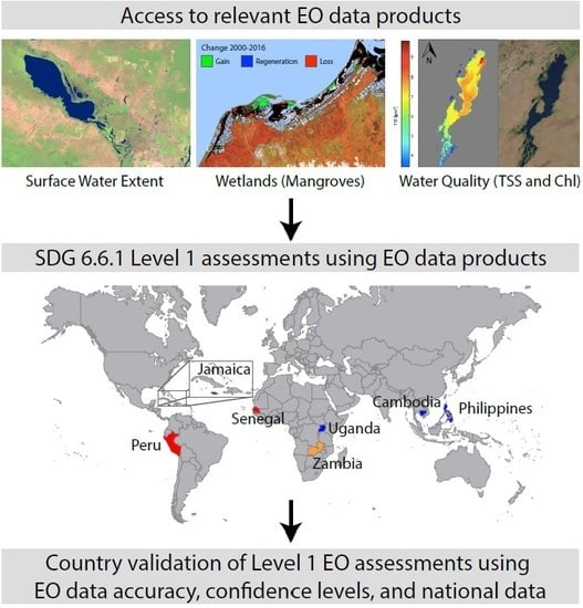
Monitoring Water-Related Ecosystems with Earth Observation Data in Support of Sustainable Development Goal (SDG) 6 Reporting
Abstract
:1. Introduction
2. Overview of the Study
3. Methodology
3.1. Spatial Extent of Surface Water Bodies
3.1.1. MODIS-based MOD44W C6.0
3.1.2. Landsat-based GLAD Surface Water
3.1.3. Landsat-based Global Surface Water Explorer
3.2. Spatial Extent of Mangroves
3.3. Water Quality of Surface Water Bodies
4. Results
4.1. Spatial Extent of Surface Water Bodies
4.2. Spatial Extent of Mangroves
4.3. Water Quality of Surface Water Bodies
5. Discussion
6. Conclusions and Recommendations
- Statistically based comparisons between multiple EO surface water data products could be used to provide some degree of confidence for the Level 1 surface water extent data, which would help countries during the Level 1 validation process. Comparisons can also help target ground-based monitoring efforts, making validation efforts more cost-effective.
- The ability to vary the threshold for persistent or permanent water would be beneficial for countries that experience a high degree of seasonality, as it is important to capture changes to seasonal water dynamics as well as permanent water.
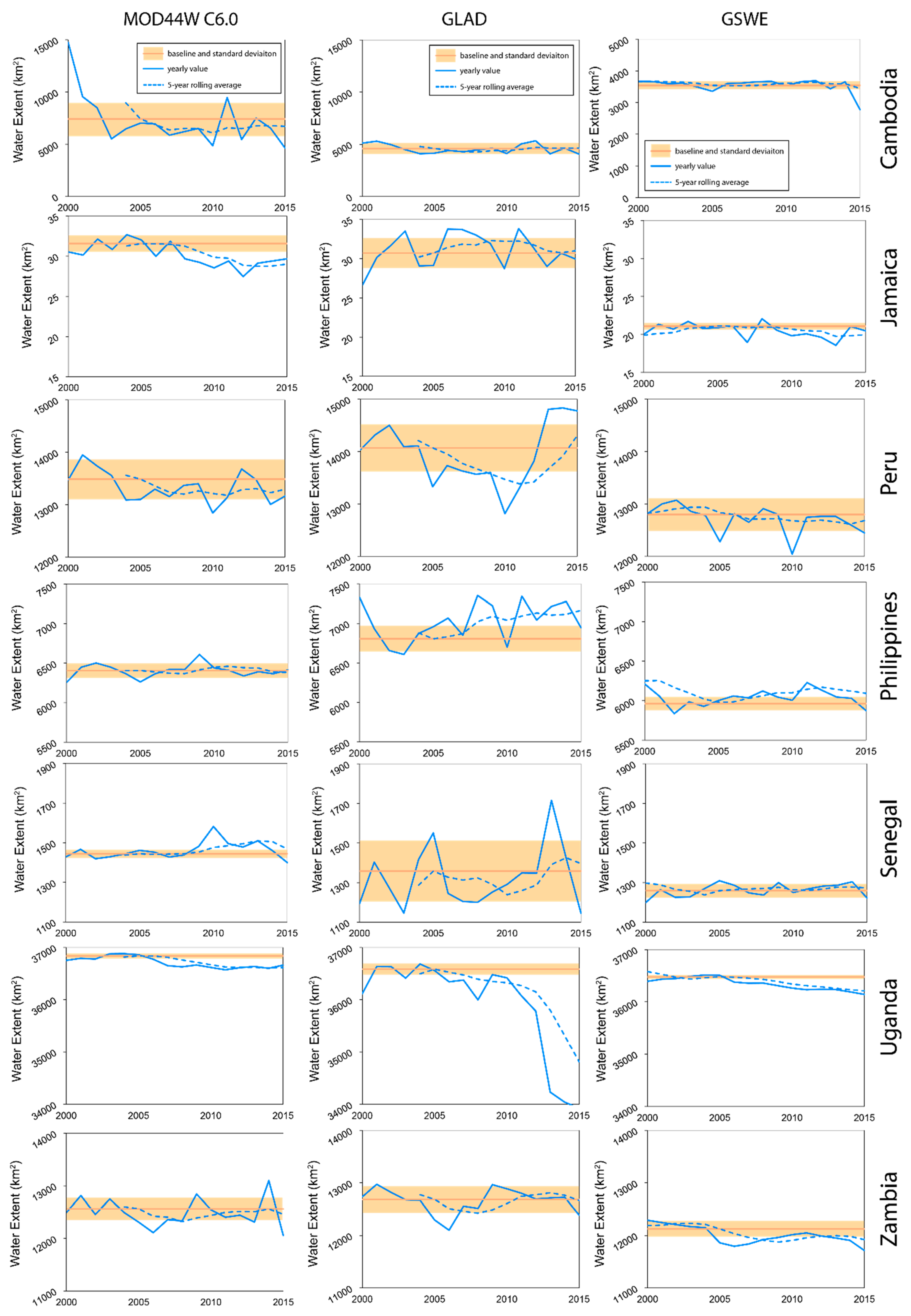
- Comparing annual or five-year average surface water extent to the baseline period of 2001 to 2005 may not correctly capture actual change in conditions for some countries that experience a high level of interannual variability as well as small islands such as Jamaica that have highly variable, yet relatively small, water and wetland features.
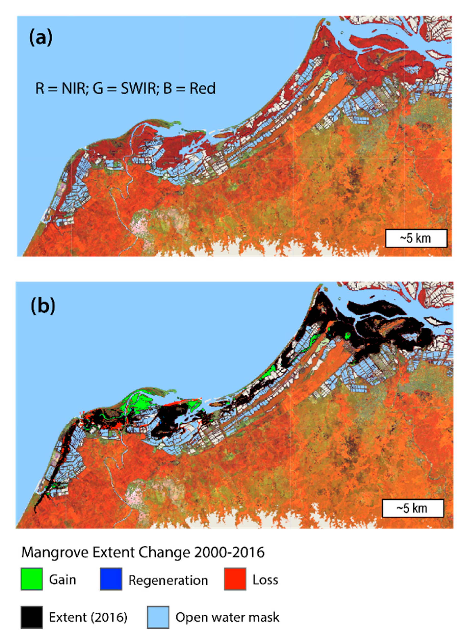
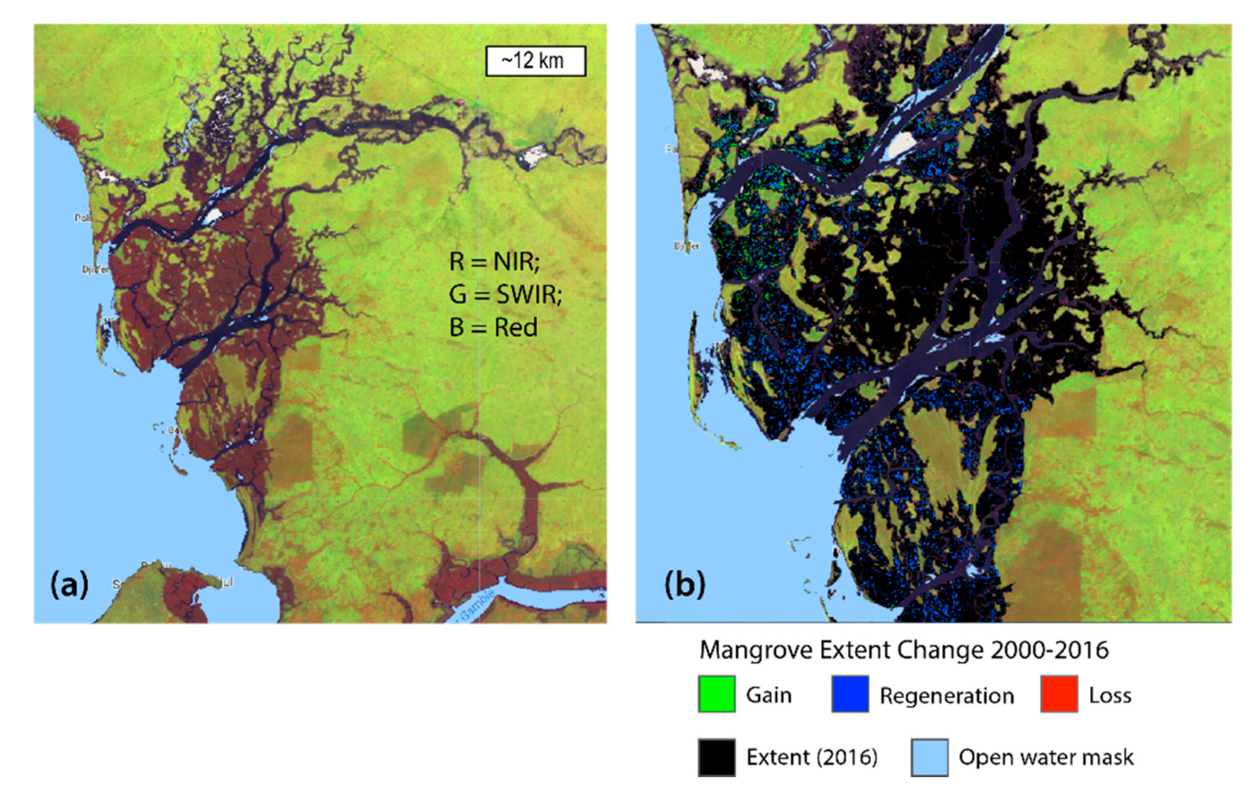
- Mangroves are highly dynamic systems, thus it is important to account for the location of persistent mangroves, the location where changes have occurred, the transitional state of change (e.g., open water to mangrove or bare soil to mangrove), as well as aggregate changes (gain vs. regeneration vs. loss). All of these parameters can easily be quantified with EO data, as illustrated.
- Identifying the type of aggregate mangrove change (gain vs. regeneration vs. loss) is an especially critical piece of information that can easily be obtained via EO data that we recommend is added to the monitoring methodology for SDG Indicator 6.6.1 in the future.
- An accuracy assessment should be conducted and included with country reporting for Indicator 6.6.1 when using EO data to track changes to wetland extent.
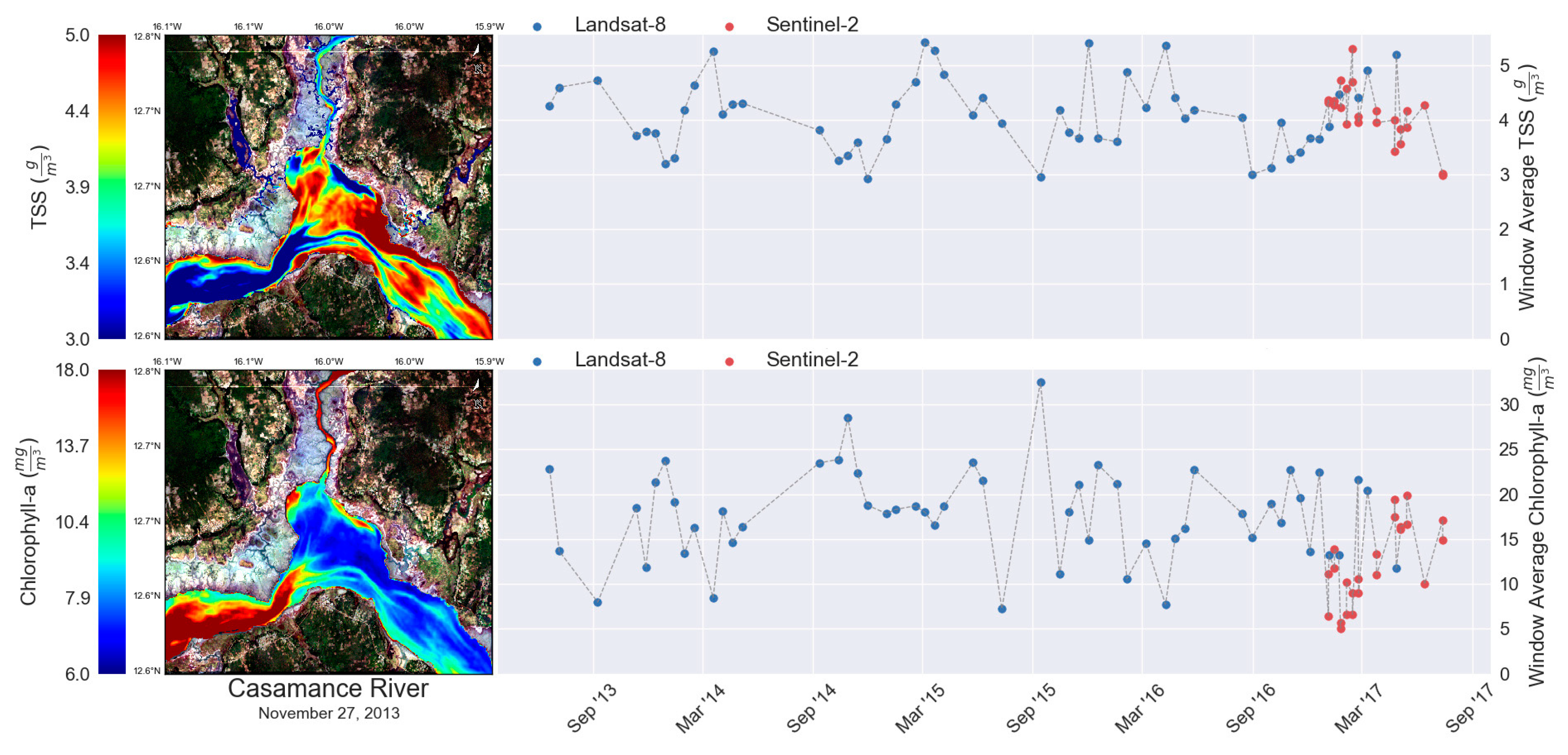
- Landsat 8 and Sentinel-2 satellite data can capture the spatial extent and seasonal changes of SDG water quality indicators of TSS and Chl in ways that ground-based monitoring cannot, which can make these EO products a great complement to existing ground-based monitoring campaigns. In other words, EO products should not replace ground-based monitoring activities.
- TSS and Chl measurements via EO present a potentially significant opportunity for SDG 6 reporting, however, application of space-based water quality information will only be an asset if it is done in close collaboration with countries that can combine it with ground-based monitoring efforts and local information.
- Data and methodology consistency is needed to achieve replicability over time, even if several different datasets are used. If datasets are updated or changed, then the baseline and all other values should be recalculated and resubmitted.
Author Contributions
Funding
Acknowledgments
Conflicts of Interest
References
- United Nations. Sustainable Development Goal 6 Synthesis Report on Water and Sanitation; United Nations: New York, NY, USA, 2018. [Google Scholar]
- UN Environment. Progress on Water-Related Ecosystems—Piloting the Monitoring Methodology and Initial Findings for SDG Indicator 6.6.1; UN Environment: Nairobi, Kenya, 2018. [Google Scholar]
- Anderson, K.; Ryan, B.; Sonntag, W.; Kavvada, A.; Friedl, L. Earth observation in service of the 2030 Agenda for Sustainable Development. Geo-Spatial Inf. Sci. 2017, 20, 77–96. [Google Scholar] [CrossRef]
- Bogardi, J.J.; Dudgeon, D.; Lawford, R.; Flinkerbusch, E.; Meyn, A.; Pahl-Wostl, C.; Vielhauer, K.; Vörösmarty, C. Water security for a planet under pressure: Interconnected challenges of a changing world call for sustainable solutions. Curr. Opin. Environ. Sustain. 2012, 4, 35–43. [Google Scholar] [CrossRef]
- Jackson, R.B.; Carpenter, S.R.; Dahm, C.N.; Mcknight, D.M.; Naiman, R.J.; Postel, S.L.; Running, S.W. Water in a Changing World. Ecol. Appl. 2001, 11, 1027–1045. [Google Scholar] [CrossRef]
- Gleick, P.H. Global freshwater resources: Soft path solutions for the 21st century. Sci. Public Policy 2003, 302, 524–528. [Google Scholar] [CrossRef] [PubMed] [Green Version]
- Vörösmarty, C.J. Global water assessment and potential contributions from Earth Systems Science. Aquat. Sci. 2002, 64, 328–351. [Google Scholar] [CrossRef]
- Vörösmarty, C.J.; Green, P.; Salisbury, J.; Lammers, R.B. Global Water Resources: Vulnerability from Climate Change and Population Growth. Science 2000, 289, 284–289. [Google Scholar] [CrossRef] [Green Version]
- Davidson, N.C. How much wetland has the world lost? Long-term and recent trends in global wetland area. Mar. Freshw. Res. 2014, 65, 934–941. [Google Scholar] [CrossRef]
- Spalding, M.; Kainuma, M.; Collins, L. World Atlas of Mangroves; Earthscan: London, UK, 2010; ISBN 9781844076574. [Google Scholar]
- Michalak, A.M. Study role of climate change in extreme threats to water quality. Nature 2016, 535, 349–352. [Google Scholar] [CrossRef]
- ICSU/ISSC. Review of Targets for the Sustainable Development Goals: The Science Perspective; ICSU/ISSC: Paris, France, 2015; ISBN 9780930357979. [Google Scholar]
- Hák, T.; Janoušková, S.; Moldan, B. Sustainable Development Goals: A need for relevant indicators. Ecol. Indic. 2016, 60, 565–573. [Google Scholar] [CrossRef]
- Feng, M.; Sexton, J.O.; Channan, S.; Townshend, J.R. A global, high-resolution (30-m) inland water body dataset for 2000: First results of a topographic–spectral classification algorithm. Int. J. Digit. Earth 2016, 9, 113–133. [Google Scholar] [CrossRef] [Green Version]
- Pekel, J.; Cottam, A.; Gorelick, N.; Belward, A.S. High-resolution mapping of global surface water and its long-term changes. Nature 2016, 540, 418–422. [Google Scholar] [CrossRef] [PubMed]
- Mueller, N.; Lewis, A.; Roberts, D.; Ring, S.; Melrose, R.; Sixsmith, J.; Lymburner, L.; McIntyre, A.; Tan, P.; Curnow, S.; et al. Water observations from space: Mapping surface water from 25years of Landsat imagery across Australia. Remote Sens. Environ. 2016, 174, 341–352. [Google Scholar] [CrossRef] [Green Version]
- Tulbure, M.G.; Broich, M.; Stehman, S.V. Spatiotemporal dynamics of Surface water extent from three decades of seasonally continuous Landsat time series at subcontinental scale. Int. Arch. Photogramm. Remote Sens. Spat. Inf. Sci.—ISPRS Arch. 2016, 41, 403–404. [Google Scholar] [CrossRef]
- Tulbure, M.G.; Broich, M. Spatiotemporal dynamic of surface water bodies using Landsat time-series data from 1999 to 2011. ISPRS J. Photogramm. Remote Sens. 2013, 79, 44–52. [Google Scholar] [CrossRef]
- Fayne, J.V.; Bolten, J.D.; Doyle, C.S.; Fuhrmann, S.; Rice, M.T.; Houser, P.R.; Lakshmi, V. Flood mapping in the lower Mekong River Basin using daily MODIS observations. Int. J. Remote Sens. 2017, 38, 1737–1757. [Google Scholar] [CrossRef]
- Brakenridge, R.; Anderson, E. MODIS-based flood detection, mapping and measurement: The potential for operational hydrological applications. In Transboundary Floods: Reducing Risks Through Flood Management; Springer: Berlin/Heidelberg, Germany, 2006; pp. 1–12. [Google Scholar]
- Policelli, F.; Slayback, D.; Brakenridge, B.; Nigro, J.; Hubbard, A.; Zaitchik, B.; Carroll, M.; Jung, H. The NASA Global Flood Mapping System. In Remote Sensing of Hydrological Extremes; Lakshmi, V., Ed.; Springer: Berlin/Heidelberg, Germany, 2016; pp. 47–63. ISBN 978-3-319-43744-6. [Google Scholar]
- Huang, C. Detecting, Extracting, and Monitoring Surface Water From Space Using Optical Sensors: A Review. Rev. Geophys. 2018, 333–360. [Google Scholar] [CrossRef]
- Guo, M.; Li, J.; Sheng, C.; Xu, J.; Wu, L. A Review of Wetland Remote Sensing. Sensors 2017, 17, 777. [Google Scholar] [CrossRef] [Green Version]
- Fatoyinbo, T.E.; Simard, M. Height and biomass of mangroves in Africa from ICESat/GLAS and SRTM. Int. J. Remote Sens. 2013, 34, 668–681. [Google Scholar] [CrossRef]
- Giri, C.; Ochieng, E.; Tieszen, L.L.; Zhu, Z.; Singh, A.; Loveland, T.; Masek, J.; Duke, N. Status and distribution of mangrove forests of the world using earth observation satellite data. Glob. Ecol. Biogeogr. 2011, 20, 154–159. [Google Scholar] [CrossRef]
- Simard, M.; Fatoyinbo, T.; Smetanka, C.; Rivera-Monroy, V.; Castaneda-Moya, E.; Thomas, N.; Van der Stocken, T. Mangrove canopy height globally related to precipitation, temperature and cyclone frequency. Nat. Geosci. 2019, 12, 40–45. [Google Scholar] [CrossRef]
- Reilly, J.E.O.; Maritorena, S.; Mitchell, B.G.; Siegel, D.A.; Carder, K.L.; Garver, S.A.; Kahru, M.; Mcclain, C. Ocean color chlorophyll algorithms for SeaWiFS encompassing chlorophyll concentrations between. J. Geophys. Res. Ocean. 1998, 103, 24937–24953. [Google Scholar] [CrossRef] [Green Version]
- Doerffer, R.; Schiller, H. The MERIS Case 2 water algorithm. Int. J. Remote Sens. 2007, 28, 517–535. [Google Scholar] [CrossRef]
- Gerace, A.D.; Schott, J.R.; Nevins, R. Increased potential to monitor water quality in the near-shore environment with Landsat’ s next-generation satellite. J. Appl. Remote Sens. 2013, 7. [Google Scholar] [CrossRef] [Green Version]
- Keith, D.J.; Schaeffer, B.A.; Lunetta, R.S.; Gould, R.W., Jr.; Rocha, K.; Cobb, D.J. Remote sensing of selected water-quality indicators with the hyperspectral imager for the coastal ocean (HICO) sensor. Int. J. Remote Sens. 2014, 35, 2927–2962. [Google Scholar] [CrossRef]
- Tyler, A.N.; Svab, E.; Preston, T.; Présing, M.; Kovács, W.A.; Svab, E.; Preston, T.; Présing, M.; Kovács, W.A. Remote sensing of the water quality of shallow lakes: A mixture modelling approach to quantifying phytoplankton in water characterized by high—Suspended sediment. Int. J. Remote Sens. 2007, 27, 1521–1537. [Google Scholar] [CrossRef]
- Bukata, R.P.; Jerome, J.H.; Kondratyev, K.Y.; Pozdnyakox, D.V. Optical Properties and Remote Sensing of Inland and Coastal Waters; CRC Press: New York, NY, USA, 1995. [Google Scholar]
- Matthews, M.W.; Bernard, S.; Winter, K. Remote Sensing of Environment Remote sensing of cyanobacteria-dominant algal blooms and water quality parameters in Zeekoevlei, a small hypertrophic lake, using MERIS. Remote Sens. Environ. 2010, 114, 2070–2087. [Google Scholar] [CrossRef]
- Singh, G.; Saraswat, D. Development and evaluation of targeted marginal land mapping approach in SWAT model for simulating water quality impacts of selected second generation biofeedstock. Environ. Model. Softw. 2016, 81, 26–39. [Google Scholar] [CrossRef] [Green Version]
- White, M.J.; Storm, D.E.; Busteed, P.; Stoodley, S.; Phillips, S.J. Evaluating Conservation Program Success with Landsat and SWAT. Environ. Manag. 2010, 1164–1174. [Google Scholar] [CrossRef]
- Swain, R.; Sahoo, B. Mapping of heavy metal pollution in river water at daily time-scale using spatio-temporal fusion of MODIS-aqua and Landsat satellite imageries. J. Environ. Manag. 2017, 192, 1–14. [Google Scholar] [CrossRef] [Green Version]
- Gao, H.; Birkett, C.; Lettenmaier, D.P. Global monitoring of large reservoir storage from satellite remote sensing data products in comparison with gauge observations for the five largest reservoirs in the. Water Resour. Res. 2012, 48, 1–12. [Google Scholar] [CrossRef] [Green Version]
- Calera, A.; Campos, I.; Osann, A.; Urso, G.D.; Menenti, M. Remote Sensing for Crop Water Management: From ET Modelling to Services for the End Users. Sensors 2017, 17, 1104. [Google Scholar] [CrossRef] [PubMed] [Green Version]
- Macalister, C.; Mahaxay, M. Mapping wetlands in the Lower Mekong Basin for wetland resource and conservation management using Landsat ETM images and field survey data. J. Environ. Manag. 2009, 90, 2130–2137. [Google Scholar] [CrossRef] [PubMed]
- Golden, H.E.; Creed, I.F.; Ali, G.; Basu, N.B.; Neff, B.P.; Rains, M.C.; Mclaughlin, D.L.; Alexander, L.C.; Ameli, A.A.; Christensen, J.R.; et al. Integrating geographically isolated wetlands into land management decisions. Front. Ecol. Environ. 2016. [Google Scholar] [CrossRef] [PubMed]
- Mccarthy, M.J.; Colna, K.E.; Pablo, A.E.L.; Otis, M.D.B.; Muller-karger, G.T.M.V.F.E. Satellite Remote Sensing for Coastal Management: A Review of Successful Applications. Environ. Manag. 2017, 323–339. [Google Scholar] [CrossRef]
- Wulder, M.A.; Li, Z.; Campbell, E.M.; White, J.C.; Hobart, G.; Hermosilla, T.; Coops, N.C. A National Assessment of Wetland Status and Trends for Canada’s Forested Ecosystems Using 33 Years of Earth Observation Satellite Data. Remote Sens. 2018, 10, 623. [Google Scholar] [CrossRef] [Green Version]
- Woodcock, C.E.; Allen, R.; Anderson, M.; Belward, A.; Bindschadler, R.; Cohen, W.; Gao, F.; Goward, S.N.; Helder, D.; Helmer, E.; et al. Free Access to Landsat Imagery. Science 2008, 1011–1013. [Google Scholar] [CrossRef]
- Wulder, M.A.; White, J.C.; Loveland, T.R.; Woodcock, C.E.; Belward, A.S.; Cohen, W.B.; Fosnight, E.A.; Shaw, J.; Masek, J.G.; Roy, D.P. The global Landsat archive: Status, consolidation, and direction. Remote Sens. Environ. 2016, 185, 271–283. [Google Scholar] [CrossRef] [Green Version]
- Gorelick, N.; Hancher, M.; Dixon, M.; Ilyushchenko, S.; Thau, D.; Moore, R. Google Earth Engine: Planetary-scale geospatial analysis for everyone. Remote Sens. Environ. 2017, 202, 18–27. [Google Scholar] [CrossRef]
- UN Environment. Monitoring Methodology for SDG Indicator 6.6.1; UN Environment: Nairobi, Kenya, 2018. [Google Scholar]
- Barbier, E.B.; Hacker, S.D.; Kennedy, C.; Koch, E.W.; Stier, A.C.; Silliman, B.R. The value of estuarine and coastal ecosystem services. Ecol. Mongraphs 2011, 81, 169–193. [Google Scholar] [CrossRef]
- Gedan, K.B.; Kirwan, M.L.; Wolanski, E.; Barbier, E.B.; Silliman, B.R. The present and future role of coastal wetland vegetation in protecting shorelines: Answering recent challenges to the paradigm. Clim. Chang. 2011, 106, 7–29. [Google Scholar] [CrossRef]
- Pendleton, L.; Donato, D.C.; Murray, B.C.; Crooks, S.; Jenkins, W.A.; Sifleet, S.; Craft, C.; Fourqurean, J.W.; Kauffman, J.B.; Marbà, N.; et al. Estimating Global “Blue Carbon” Emissions from Conversion and Degradation of Vegetated Coastal Ecosystems. PLoS ONE 2012, 7. [Google Scholar] [CrossRef] [PubMed] [Green Version]
- Carroll, M.L.; DiMiceli, C.M.; Wooten, M.R.; Hubbard, A.B.; Sohlberg, R.A.; Townshend, J.R.G. MOD44W MODIS/Terra Land Water Mask Derived from MODIS and SRTM L3 Global 250m SIN Grid V006 [Data Set]; NASA EOSDIS Land Processes DAAC, 2017. Available online: https://doi.org/10.5067/MODIS/MOD44W.006 (accessed on 1 October 2017).
- Carroll, M.L.; Townshend, J.R.; DiMiceli, C.M.; Noojipady, P.; Sohlberg, R.A. A new global raster water mask at 250 m resolution. Int. J. Digit. Earth 2009, 2, 291–308. [Google Scholar] [CrossRef]
- Pickens, A.H.; Hansen, M.C.; Hancher, M.; Stehman, S.V.; Tyukavina, A.; Potapov, P.; Marroquin, B.; Sherani, Z. Dynamics of global surface water derived from full 1999-2018 Landsat archive time-series. Remote Sens. Environ. 2020, 243, 111792. [Google Scholar] [CrossRef]
- Potapov, P.V.; Turubanova, S.A.; Hansen, M.C.; Adusei, B.; Broich, M.; Altstatt, A.; Mane, L.; Justice, C.O. Quantifying forest cover loss in Democratic Republic of the Congo, 2000–2010, with Landsat ETM + data. Remote Sens. Environ. 2012, 122, 106–116. [Google Scholar] [CrossRef]
- Green, A.E.P.; Mumby, P.J.; Edwards, A.J.; Clark, C.D.; Ellis, A.C.; Greent, E.P.; Mumbyt, P.J.; Edwardst, A.J.; Clark, C.D.; Ellistt, A.C. The Assessment of Mangrove Areas Using High Resolution Multispectral Airborne Imagery. J. Coast. Res. 1998, 14, 433–443. [Google Scholar]
- Lagomasino, D.; Fatoyinbo, T.; Lee, S.; Feliciano, E.; Trettin, C.; Shapiro, A.; Mangora, M.M. Measuring mangrove carbon loss and gain in deltas. Environ. Res. Lett. 2019, 14. [Google Scholar] [CrossRef]
- Nechad, B.; Ruddick, K.G.; Park, Y. Calibration and validation of a generic multisensor algorithm for mapping of total suspended matter in turbid waters. Remote Sens. Environ. 2010, 114, 854–866. [Google Scholar] [CrossRef]
- O’Reilly, J.E.; Maritorena, S.; Siegel, D.A.; O’Brien, M.C.; Toole, D.; Mitchell, B.G.; Kahru, M.; Chavez, F.P.; Strutton, P.; Cota, G.F.; et al. Ocean color chlorophyll a algorithms for SeaWiFS, OC2, and OC4: Version 4. SeaWiFS Postlaunch 2000, 8–22. [Google Scholar] [CrossRef]
- Pahlevan, N.; Schott, J.R.; Franz, B.A.; Zibordi, G.; Markham, B.; Bailey, S.; Schaaf, C.B.; Ondrusek, M.; Greb, S.; Strait, C.M. Landsat 8 remote sensing reflectance (Rrs) products: Evaluations, intercomparisons, and enhancements. Remote Sens. Environ. 2017, 190, 289–301. [Google Scholar] [CrossRef]
- Pahlevan, N.; Sarkar, S.; Franz, B.A.; Balasubramanian, S.V.; He, J. Sentinel-2 MultiSpectral Instrument (MSI) data processing for aquatic science applications: Demonstrations and validations. Remote Sens. Environ. 2017, 201, 47–56. [Google Scholar] [CrossRef]
- Gordon, H.R.; Wang, M. Retrieval of water-leaving radiance and aerosol optical thickness over the oceans with SeaWiFS: A preliminary algorithm. Appl. Opt. 1994, 33, 443. [Google Scholar] [CrossRef] [PubMed]
- Pahlevan, N.; Chittimalli, S.K.; Balasubramanian, S.V.; Vellucci, V. Sentinel-2/Landsat-8 product consistency and implications for monitoring aquatic systems. Remote Sens. Environ. 2019, 220, 19–29. [Google Scholar] [CrossRef]
- Lyon, B.; Dewitt, D.G. A recent and abrupt decline in the East African long rains. Geophys. Res. Lett. 2012, 39, 1–5. [Google Scholar] [CrossRef] [Green Version]
- Tierney, J.E.; Smerdon, J.E.; Anchukaitis, K.J.; Seager, R. Multidecadal variability in East African hydroclimate. Nature 2013, 493, 389–392. [Google Scholar] [CrossRef] [PubMed] [Green Version]
- Olofsson, P.; Foody, G.M.; Herold, M.; Stehman, S.V.; Woodcock, C.E.; Wulder, M.A. Good practices for estimating area and assessing accuracy of land change. Remote Sens. Environ. 2014, 148, 42–57. [Google Scholar] [CrossRef]
- Cormier-Salem, M.C.; Panfili, J. Mangrove reforestation: Greening or grabbing coastal zones and deltas? Case studies in Senegal. African J. Aquat. Sci. 2016, 41, 89–98. [Google Scholar] [CrossRef]
- Livelihoods Funds SENEGAL: The Largest Mangrove Restoration Programme in the World. Available online: http://www.livelihoods.eu/projects/oceanium-senegal/ (accessed on 20 August 2011).
- McGillis, W.R.; Hsueh, D.Y.; Zheng, Y.; Markowitz, M.; Gibson, R.; Bolduc, G.; Fevrin, F.J.; Thys, J.E.; Noel, W.; Paine, J.; et al. Carbon transport in rivers of southwest Haiti. Appl. Geochem. 2015. [Google Scholar] [CrossRef]
- Foody, G.M. Remote Sensing of Environment Assessing the accuracy of land cover change with imperfect ground reference data. Remote Sens. Environ. 2010, 114, 2271–2285. [Google Scholar] [CrossRef] [Green Version]
- Bunting, P.; Rosenqvist, A.; Lucas, R.M.; Rebelo, L.; Hilarides, L.; Thomas, N.; Hardy, A.; Itoh, T.; Shimada, M.; Finlayson, C.M. The Global Mangrove Watch—A New 2010 Global Baseline of Mangrove Extent. Remote Sens. 2018, 10, 1669. [Google Scholar] [CrossRef] [Green Version]
- Goldberg, L.; Lagomasino, D.; Fatoyinbo, T. EcoMap: A Decision-Support Tool to Monitor Global Mangrove Vulnerability and its Drivers. In Proceedings of the AGU Fall Meeting Abstracts, San Francisco, CA, USA, 7–11 December 2018. [Google Scholar]
- Spyrakos, E.; Donnell, R.O.; Hunter, P.D.; Miller, C.; Scott, M.; Simis, S.G.H.; Neil, C.; Barbosa, C.C.F.; Binding, C.E.; Bradt, S.; et al. Optical types of inland and coastal waters. Limnol. Oceanogr. 2018, 846–870. [Google Scholar] [CrossRef] [Green Version]







| Water-Related Ecosystem Category | Extent Component | Dataset(s) | Spatial Resolution (m) |
|---|---|---|---|
| Rivers and estuaries, lakes | Spatial extent | MOD44W C6.0 | 250 |
| Rivers and estuaries, lakes | Spatial extent | GLAD Surface Water, JRC Global Surface Water Explorer | 30 |
| Wetlands (mangroves only) | Spatial extent | Landsat 8, Sentinel-1, SRTM | 30 |
| Lakes, rivers | Quality (TSS and Chl only) | Landsat 8, Sentinel-2A/B | 20–30 |
| Spatial Extent of Mangrove Wetlands (km2) | ||||
|---|---|---|---|---|
| Country | Loss(2000–2016) | Gains(2000–2016) | Extent 2016 | %Δ(2016–2000) |
| Senegal | 15.2 ± 2 | 56.2 ± 16 | 1602.1 ± 67.8 | 2.6% |
| Peru | 2.4 ± 0.5 | 4.5 ± 0.8 | 49.2 ± 2.7 | 4.5% |
| Jamaica | 5.3 ± 1.1 | 2.8 ± 0.9 | 74.1 ± 4.2 | −3.3% |
© 2020 by the authors. Licensee MDPI, Basel, Switzerland. This article is an open access article distributed under the terms and conditions of the Creative Commons Attribution (CC BY) license (http://creativecommons.org/licenses/by/4.0/).
Share and Cite
Hakimdavar, R.; Hubbard, A.; Policelli, F.; Pickens, A.; Hansen, M.; Fatoyinbo, T.; Lagomasino, D.; Pahlevan, N.; Unninayar, S.; Kavvada, A.; et al. Monitoring Water-Related Ecosystems with Earth Observation Data in Support of Sustainable Development Goal (SDG) 6 Reporting. Remote Sens. 2020, 12, 1634. https://doi.org/10.3390/rs12101634
Hakimdavar R, Hubbard A, Policelli F, Pickens A, Hansen M, Fatoyinbo T, Lagomasino D, Pahlevan N, Unninayar S, Kavvada A, et al. Monitoring Water-Related Ecosystems with Earth Observation Data in Support of Sustainable Development Goal (SDG) 6 Reporting. Remote Sensing. 2020; 12(10):1634. https://doi.org/10.3390/rs12101634
Chicago/Turabian StyleHakimdavar, Raha, Alfred Hubbard, Frederick Policelli, Amy Pickens, Matthew Hansen, Temilola Fatoyinbo, David Lagomasino, Nima Pahlevan, Sushel Unninayar, Argyro Kavvada, and et al. 2020. "Monitoring Water-Related Ecosystems with Earth Observation Data in Support of Sustainable Development Goal (SDG) 6 Reporting" Remote Sensing 12, no. 10: 1634. https://doi.org/10.3390/rs12101634
APA StyleHakimdavar, R., Hubbard, A., Policelli, F., Pickens, A., Hansen, M., Fatoyinbo, T., Lagomasino, D., Pahlevan, N., Unninayar, S., Kavvada, A., Carroll, M., Smith, B., Hurwitz, M., Wood, D., & Schollaert Uz, S. (2020). Monitoring Water-Related Ecosystems with Earth Observation Data in Support of Sustainable Development Goal (SDG) 6 Reporting. Remote Sensing, 12(10), 1634. https://doi.org/10.3390/rs12101634


