The High-Resolution Digital-Beamforming Airborne SAR System DBFSAR
Abstract
:1. Introduction
2. DBFSAR Instrument Design
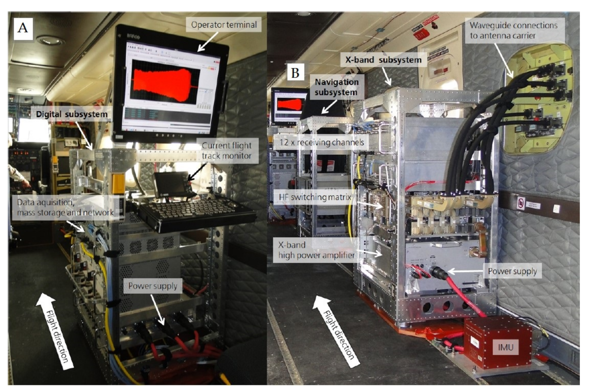
- Digital subsystem: The digital backend includes the data acquisition to sample and record 12 receive channels with 2 GHz bandwidth individual, as well as the complete system control and a user console for the flight operator.
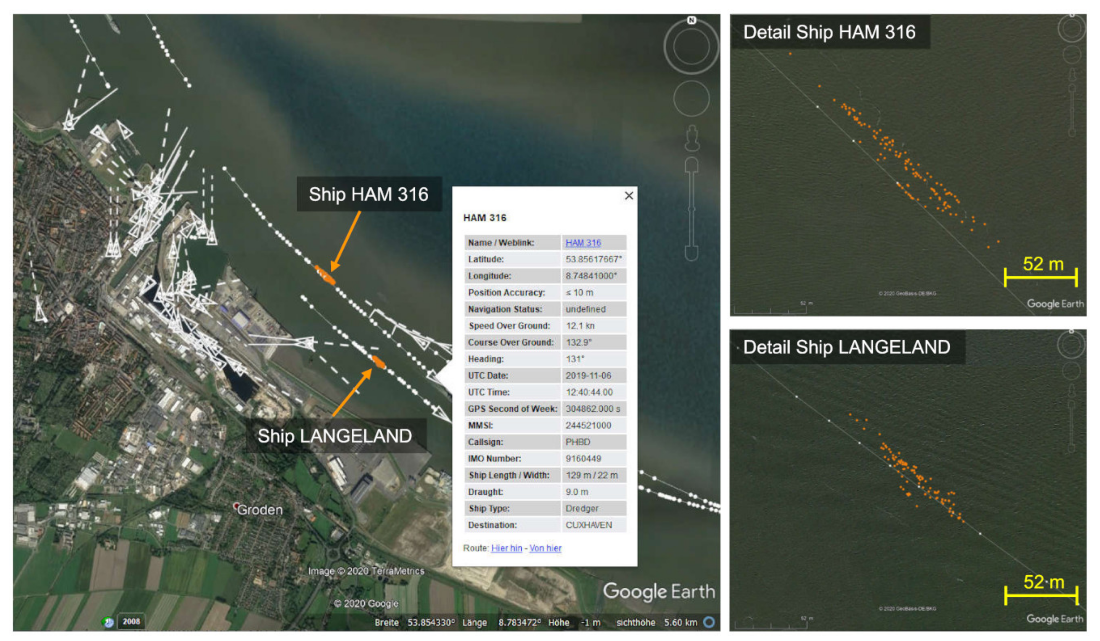
- Navigation subsystem: The navigation rack provides the mission in-flight pattern for the pilot and records the GPS (global positioning system) position and the IMU (inertial measurement unit) data for real-time on-board or post processing. Additionally, an AIS (automatic identification system) receiver and a LTE (long-term evolution) modem for data transmission are implemented.
- X-band subsystem: The front-end contains all HF (high-frequency) components, including the X-band high power amplifier. It features 12 simultaneous receive and 4 sequential transmit channels with 1.8 GHz analogue bandwidth each.
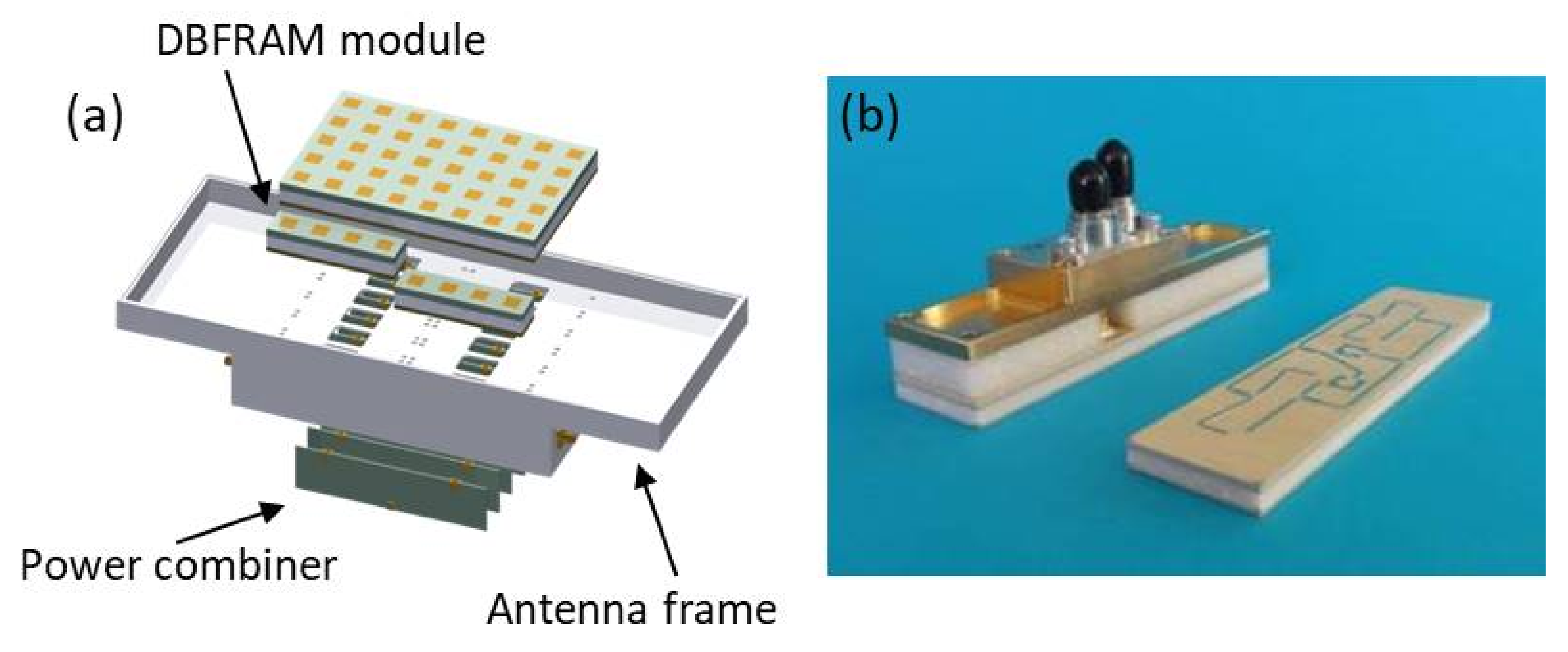
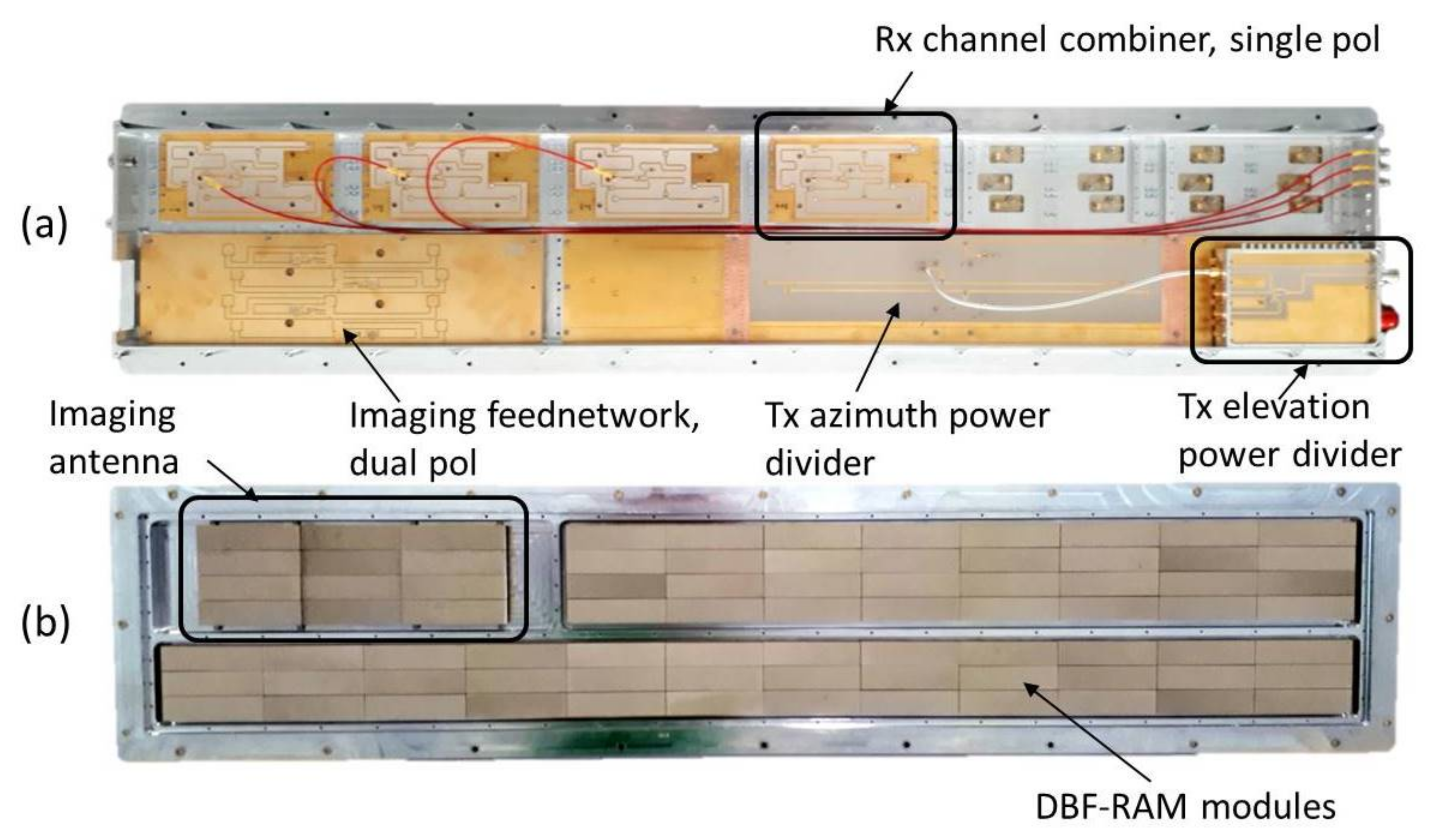
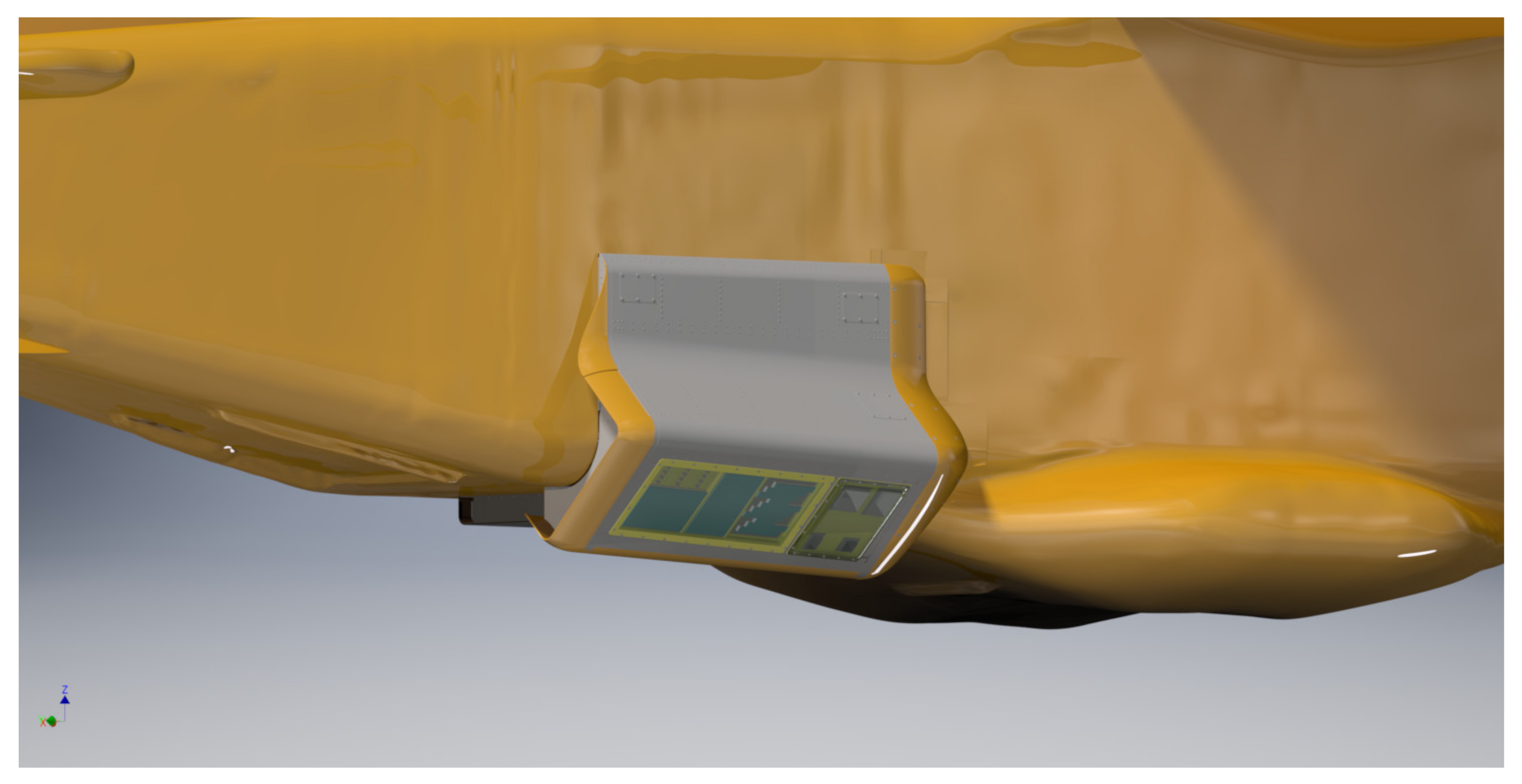
- DBF antennas: The antenna configuration consists of a dedicated antenna carrier, carrying 4 single-pol X-band transmit antennas, aligned in H and V direction forming wide or narrow beams, and 12 receive antennas, which can be arranged in various configurations. Alternatively, a dedicated MTI antenna system, the V-SAR antenna, can be mounted.
2.1. The Digital Subsystem
2.2. The Navigation Subsystem
2.3. The X-Band Subsystem
2.4. DBF Antenna Configurations
3. Multi-Channel Sensor Calibration
4. Test Flights and Experimental Results
4.1. First Imaging Results
- Only two F-SAR antennas have been mounted in an interferometric XTI configuration. Consequently, no DBF modes have been tested yet. However, both antennas are dual-pol, so that simultaneous receive on four channels could be demonstrated.
- The F-SAR X-band antennas are not designed for DBFSAR’s 1.8 GHz bandwidth. For this experiment, it was decided to limit the bandwidth to the 800 MHz, which fits well to the operation capability of the F-SAR antennas.
4.2. First Interferometric Results
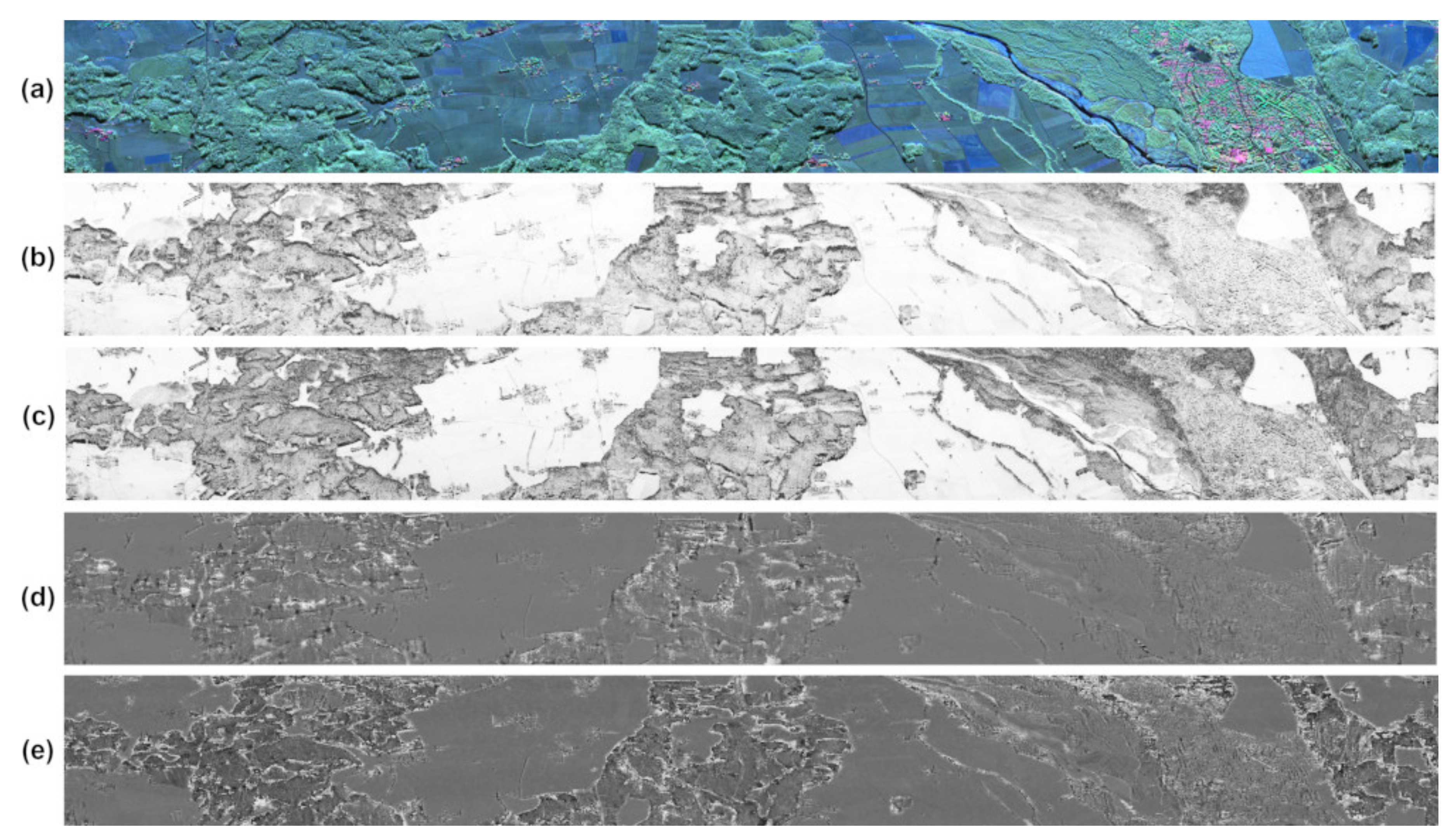
- the across-track channels’ operation for the XTI Pol-InSAR mode on antennas X1 and X2, which makes use of all four Tx-pulses of the sequence; and
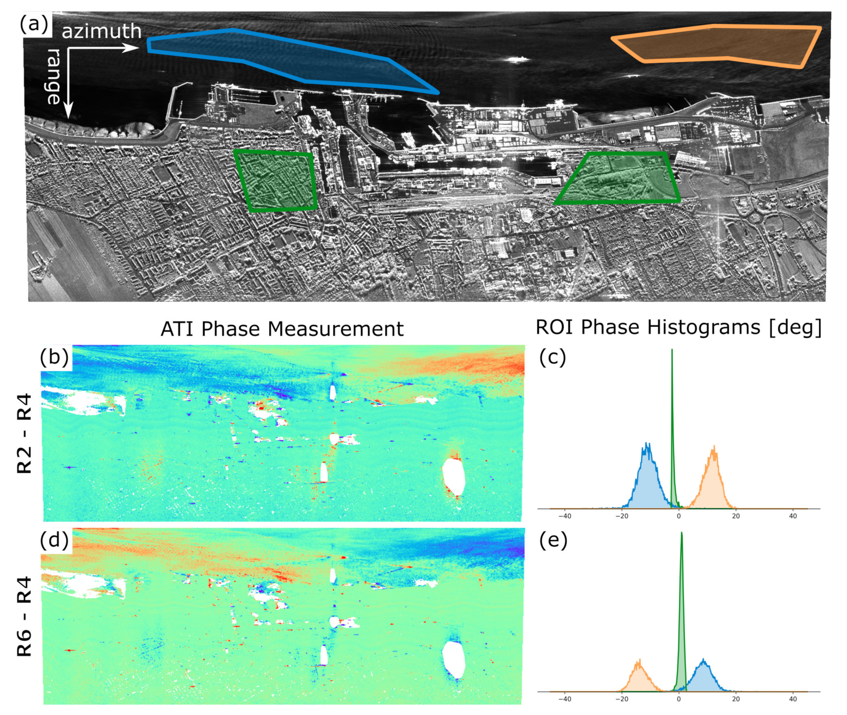
- the along-track channels’ operation for the ATI mode on antennas X2 and X3, which involves Pulses 2 and 4 only.
4.3. First Ship Detection and Tracking Results Obtained with the V-SAR Subsystem
5. Discussion
6. Conclusions and Outlook
Author Contributions
Funding
Conflicts of Interest
References
- Tomiyasu, K. Conceptual Performance of a Satellite Borne, Wide Swath Synthetic Aperture Radar. IEEE Trans. Geosci. Remote Sens. 1981, 19, 108–116. [Google Scholar] [CrossRef]
- Gebert, N.; Krieger, G.; Moreira, A. Digital Beamforming on Receive: Techniques and Optimization Strategies for High-Resolution Wide-Swath SAR Imaging. IEEE Trans. Aerosp. Electron. Syst. 2009, 45, 564–592. [Google Scholar] [CrossRef] [Green Version]
- Smolders, B.; Hampson, G. Deterministic RF nulling in phased arrays for the next generation of radio telescopes. IEEE Antennas Propag. Mag. 2002, 44, 13–22. [Google Scholar] [CrossRef] [Green Version]
- Bollian, T.; Osmanoglu, B.; Rincon, R.F.; Lee, S.; Fatoyinbo, T. Digital Beamforming Based RFI Mitigation for Synthetic Aperture Radar. In Proceedings of the IGARSS 2018—2018 IEEE International Geoscience and Remote Sensing Symposium, Valencia, Spain, 22–27 July 2018; pp. 323–325. [Google Scholar]
- Krieger, G.; Moreira, A. Spaceborne bi- and multistatic SAR: Potential and challenges. IEE Proc. Radar Sonar Navig. 2006, 153, 184–198. [Google Scholar] [CrossRef] [Green Version]
- Klemm, R. Principles of Space-Time Adaptive Processing; Radar, Sonar & Navigation; Institution of Engineering and Technology: London, UK, 2006. [Google Scholar]
- Younis, M.; Fischer, C.; Wiesbeck, W. Digital beamforming in SAR systems. IEEE Trans. Geosci. Remote Sens. 2003, 41, 1735–1739. [Google Scholar] [CrossRef]
- Rincon, R.F.; Vega, M.A.; Buenfil, M.; Geist, A.; Hilliard, L.; Racette, P. NASA’s L-Band Digital Beamforming Synthetic Aperture Radar. IEEE Trans. Geosci. Remote Sens. 2011, 49, 3622–3628. [Google Scholar] [CrossRef]
- Rincon, R.; Fatoyinbo, T.; Osmanoglu, B.; Lee, S.; Ranson, K.J.; Marrero, V.; Yeary, M. Development of NASA’S Next Generation L-Band Digital Beamforming Synthetic Aperture Radar (DBSAR-2). In Proceedings of the EUSAR 2016, Hamburg, Germany, 6–9 June 2016; pp. 1–4. [Google Scholar]
- Sadowy, G.; Ghaemi, H.; Heavey, B.; Perkovic, D.; Zawadzki, M.; Moller, D. Ka-Band Digital Beamforming and SweepSAR Demonstration for Ice and Solid Earth Topography. In Proceedings of the 8th European Conference on Synthetic Aperture Radar, Aachen, Germany, 7–10 June 2010; pp. 1–4. [Google Scholar]
- Rosen, P.; Hensley, S.; Shaffer, S.; Edelstein, W.; Kim, Y.; Kumar, R.; Misra, T.; Bhan, R.; Sagi, R. The NASA-ISRO SAR (NISAR) mission dual-band radar instrument preliminary design. In Proceedings of the 2017 IEEE International Geoscience and Remote Sensing Symposium (IGARSS), Fort Worth, TX, USA, 23–28 July 2017; pp. 3832–3835. [Google Scholar]
- Moreira, A.; Krieger, G.; Hajnsek, I.; Papathanassiou, K.; Younis, M.; Lopez-Dekker, P.; Huber, S.; Villano, M.; Pardini, M.; Eineder, M.; et al. Tandem-L: A Highly Innovative Bistatic SAR Mission for Global Observation of Dynamic Processes on the Earth’s Surface. IEEE Geosci. Remote Sens. Mag. 2015, 3, 8–23. [Google Scholar] [CrossRef]
- Wang, H.; Dai, S.; Zheng, S. Airborne Ka-band digital beamforming SAR system and flight test. In Proceedings of the 2017 International Workshop on Remote Sensing with Intelligent Processing (RSIP), Shanghai, China, 18–21 May 2017; pp. 1–4. [Google Scholar]
- Reigber, A.; Scheiber, R.; Jager, M.; Prats-Iraola, P.; Hajnsek, I.; Jagdhuber, T.; Papathanassiou, K.P.; Nannini, M.; Aguilera, E.; Baumgartner, S.; et al. Very-High-Resolution Airborne Synthetic Aperture Radar Imaging: Signal Processing and Applications. Proc. IEEE 2013, 101, 759–783. [Google Scholar] [CrossRef] [Green Version]
- Horn, R.; Nottensteiner, A.; Reigber, A.; Fischer, J.; Scheiber, R. F-SAR—DLR’s new multifrequency polarimetric airborne SAR. In Proceedings of the 2009 IEEE International Geoscience and Remote Sensing Symposium, Cape Town, South Africa, 12–17 July 2009; Volume 2, pp. II–902–II–905. [Google Scholar]
- Kremer, J. CCNS and Aerocontrol: Products for efficient photogrammetric data collection. In Photogrammetric Week 2001; Institute for Photogrammetry: Stuttgart, Germany, 2001. [Google Scholar]
- Scheiber, R.; van Kempen, M. AIS Assisted Identification and Refocussing of Ships in Airborne SAR Images. In Proceedings of the European Conference on Synthetic Aperture Radar (EUSAR). VDE, Aachen, Germany, 4–7 June 2018; pp. 1193–1196. [Google Scholar]
- Jäger, M.; Scheiber, R.; Reigber, A. Robust, Model-Based External Calibration of Multi-Channel Airborne SAR Sensors Using Range Compressed Raw Data. Remote Sens. 2019, 11, 2674. [Google Scholar] [CrossRef] [Green Version]
- Lee, J.; Pottier, E. Polarimetric Radar Imaging: From Basics to Applications; Optical Science and Engineering; CRC Press: Boca Raton, FL, USA, 2009. [Google Scholar]
- Xie, Q.; Zhu, J.; Wang, C.; Fu, H.; Lopez-Sanchez, J.M.; Ballester-Berman, J.D. A Modified Dual-Baseline PolInSAR Method for Forest Height Estimation. Remote Sens. 2017, 9, 819. [Google Scholar] [CrossRef] [Green Version]
- Martone, M.; Sica, F.; Gonzalez, C.; Bello, J.L.B.; Valdo, P.; Rizzoli, P. High-resolution forest mapping from TanDEM-X interferometric data exploiting nonlocal filtering. Remote Sens. 2018, 10, 1477. [Google Scholar] [CrossRef] [Green Version]
- Martone, M.; Rizzoli, P.; Wecklich, C.; González, C.; Bueso-Bello, J.L.; Valdo, P.; Schulze, D.; Zink, M.; Krieger, G.; Moreira, A. The global forest/non-forest map from TanDEM-X interferometric SAR data. Remote Sens. Environ. 2018, 205, 352–373. [Google Scholar] [CrossRef]
- Hirche, R. AIS (Automatic Identification System) in Theorie und Praxis: Das Navigations- und Sicherheitssystem der Zukunft, 1st ed.; Delius Klasing: Bielefeld, Germany, 2009. [Google Scholar]
- Fingas, M.; Brown, C. Review of Ship Detection from Airborne Platforms. Can. J. Remote Sens. 2001, 27, 379–385. [Google Scholar] [CrossRef]
- Brusch, S.; Lehner, S.; Fritz, T.; Soccorsi, M.; Soloviev, A.; van Schie, B. Ship Surveillance With TerraSAR-X. IEEE Trans. Geosci. Remote Sens. 2011, 49, 1092–1103. [Google Scholar] [CrossRef]
- Joshi, S.K.; Baumgartner, S.V.; da Silva, A.B.C.; Krieger, G. Range-Doppler Based CFAR Ship Detection with Automatic Training Data Selection. Remote Sens. 2019, 11, 1270. [Google Scholar] [CrossRef] [Green Version]
- Kalman, R.E. A new approach to linear filtering and prediction problems. J. Basic Eng. 1960, 82, 35–45. [Google Scholar] [CrossRef] [Green Version]
- Baumgartner, S.V. Linear and Circular ISAR Imaging of Ships Using DLR’s Airborne Sensor F-SAR. In Proceedings of the International Conference on Radar Systems (IET Radar 2017), Belfast, UK, 23–26 October 2017. [Google Scholar]
- Baumgartner, S.V. Circular and Polarimetric ISAR Imaging of Ships Using Airborne SAR Sensors. In Proceedings of the 12th European Conference on Synthetic Aperture Radar (EUSAR 2018), Aachen, Germany, 4–7 June 2018; pp. 116–121. [Google Scholar]
- Free AIS Ship Tracking of Marine Traffic - VesselFinder. Available online: https://www.vesselfinder.com/vessels/HAM-316-IMO-9160449-MMSI-244521000 (accessed on 29 April 2020).
- Free AIS Ship Tracking of Marine Traffic - VesselFinder. Available online: https://www.vesselfinder.com/vessels/LANGELAND-IMO-8420098-MMSI-211204290 (accessed on 29 April 2020).
- Baumgartner, S.V.; Krieger, G. Multi-Channel SAR for Ground Moving Target Indication. In Academic Press Library in Signal Processing: Communications and Radar Signal Processing, 1st ed.; Chellappa, R., Theodoridis, S., Eds.; Academic Press: Cambridge, MA, USA, 2014; Volume 2, chapter 18; pp. 911–986. ISBN 978-0-12-396500-4. [Google Scholar]
- Melvin, W.L. A STAP Overview. IEEE Aerosp. Electron. Syst. Mag. 2004, 19, 19–35. [Google Scholar] [CrossRef]
- Ender, J.H.G.; Gierull, C.H.; Cerutti-Maori, D. Improved Space-Based Moving Target Indication via Alternate Transmission and Receiver Switching. IEEE Trans. Geosci. Remote Sens. 2008, 46, 3960–3974. [Google Scholar] [CrossRef]
- Barros Cardoso da Silva, A.; Baumgartner, S.V.; Krieger, G. Training Data Selection and Update Strategies for Airborne Post-Doppler STAP. IEEE Trans. Geosci. Remote Sens. 2019, 57, 5626–5641. [Google Scholar] [CrossRef] [Green Version]
- Cerutti-Maori, D.; Klare, J.; Brenner, A.R.; Ender, J.G.H. Wide Area Traffic Monitoring with the SAR/GMTI System PAMIR. Trans. Geosci. Remote Sens. 2008, 46, 3019–3030. [Google Scholar] [CrossRef]
- Adamiuk, G.; Heer, C.; Ludwig, M. DBF Technology Development for Next Generation of ESA C-Band SAR mission. In Proceedings of the EUSAR 2016, Hamburg, Germany, 6–9 June 2016; pp. 1–4. [Google Scholar]
- Salvo, M.D.; Perrera, A.; Degiorgi, M.; Ritorto, A.; Vinciguerra, L.; Temussi, F.; Villano, M.; Krieger, G.; de Almeida, F.Q.; Reimann, J.; et al. ROSE-L EO System—Mission and Instrument Performance Assessment. In Proceedings of the Advanced Remote Sensing Instruments (ARSI), Noordwijk, The Netherlands, 11–13 November 2019. [Google Scholar]
- Zonno, M.; Bordoni, F.; Matar, J.; de Almeida, F.Q.; Ferrer, M.J.S.; Younis, M.; Cassola, M.R.; Krieger, G. Sentinel-1 Next Generation: Trade-offs and Assessment of Mission Performance. In Proceedings of the ESA Living Planet Symposium, Milan, Italy, 13–17 May 2019. [Google Scholar]






| Parameter | Value | Parameter | Value | Parameter | Value |
|---|---|---|---|---|---|
| Center frequency | 9.5 GHz | Tx channels | 4 | Polarization | Full polarimetric |
| Bandwidth | 1.8 GHz | Rx channels | 12 | Tx ant. 3 dB width | 16/34 |
| Pulse power | 2 kW | Sampling | 12 × 4 GS/s | Tx ant. gain | 21 dBi/15 dBi |
| Duty cycle max. | 10 % | Network | 10 Gbit Ethernet | Flight recording | IGI/Applanix |
| Signal length max. | 36 s | Data storage | 6 TB | Equip. 1 | LTE comlink |
| PRF max. | 10 kHz | DC Power | 3600 W | Equip. 2 | AIS receiver |
| Pulse Number | 1 | 2 | 3 | 4 | |||||
|---|---|---|---|---|---|---|---|---|---|
| Antenna # | Polarization | Tx | Rx | Tx | Rx | Tx | Rx | Tx | Rx |
| X1 | H | - | x | - | x | x | x | - | x |
| X1 | V | x | x | - | x | - | x | - | x |
| X2 | H | - | x | - | x | - | x | x | x |
| X2 | V | - | x | x | x | - | x | - | x |
| X3 | H | - | x | - | x | - | x | - | x |
| X3 | V | - | x | - | x | - | x | - | x |
© 2020 by the authors. Licensee MDPI, Basel, Switzerland. This article is an open access article distributed under the terms and conditions of the Creative Commons Attribution (CC BY) license (http://creativecommons.org/licenses/by/4.0/).
Share and Cite
Reigber, A.; Schreiber, E.; Trappschuh, K.; Pasch, S.; Müller, G.; Kirchner, D.; Geßwein, D.; Schewe, S.; Nottensteiner, A.; Limbach, M.; et al. The High-Resolution Digital-Beamforming Airborne SAR System DBFSAR. Remote Sens. 2020, 12, 1710. https://doi.org/10.3390/rs12111710
Reigber A, Schreiber E, Trappschuh K, Pasch S, Müller G, Kirchner D, Geßwein D, Schewe S, Nottensteiner A, Limbach M, et al. The High-Resolution Digital-Beamforming Airborne SAR System DBFSAR. Remote Sensing. 2020; 12(11):1710. https://doi.org/10.3390/rs12111710
Chicago/Turabian StyleReigber, Andreas, Eric Schreiber, Kurt Trappschuh, Sebastian Pasch, Gerhard Müller, Daniel Kirchner, Daniel Geßwein, Stefan Schewe, Anton Nottensteiner, Markus Limbach, and et al. 2020. "The High-Resolution Digital-Beamforming Airborne SAR System DBFSAR" Remote Sensing 12, no. 11: 1710. https://doi.org/10.3390/rs12111710
APA StyleReigber, A., Schreiber, E., Trappschuh, K., Pasch, S., Müller, G., Kirchner, D., Geßwein, D., Schewe, S., Nottensteiner, A., Limbach, M., Schreiber, A., Rommel, T., Horn, R., Jäger, M., Scheiber, R., Baumgartner, S. V., Joshi, S. K., Barros Cardoso da Silva, A., & Moreira, A. (2020). The High-Resolution Digital-Beamforming Airborne SAR System DBFSAR. Remote Sensing, 12(11), 1710. https://doi.org/10.3390/rs12111710


