The identification of agriculture areas is valuable information for the scientific community, government agencies, farmers, and other members of the society. Agriculture main commodity areas are monitored on a global scale to predict production, yield, demand, prices, climate risks, and so forth [
1,
2,
3,
4,
5]. Related statistics are produced and published to reduce the economic externalities impact and to balance market information asymmetry [
6,
7]. Ongoing, accurate, and timely crop information remains a challenge, as data becomes available long after the harvesting time, and the machine learning classification is dependent on reliable data sources and processing needs enhancements, despite the available capacity [
8,
9,
10]. The accuracy of the latest results in distiguishing crops of agriculture areas range from 84% to 95% [
11,
12,
13,
14]. The state of the art publications in agriculture remote sensing explore the importance of machine learning applied in combined data sources and types in order to enhance the process and accuracy for multiple crops as classes.
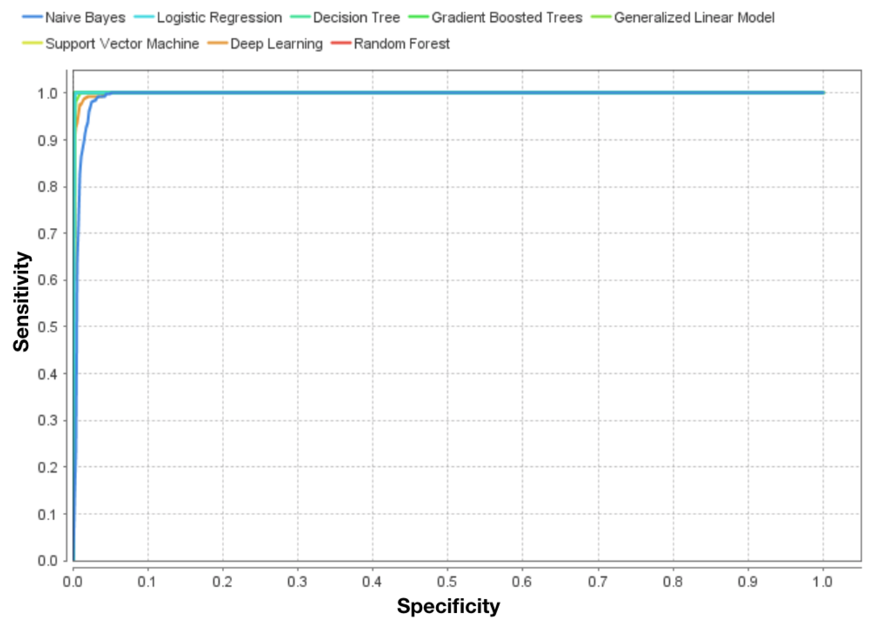
When it comes to process improvements and machine learning, Convolutional Neural Networks (CNN) was applied to achieved significant results in image recognition tasks by automatically learning a hierarchical feature representation from raw data, and through combinations of time series (temporal dimension) with 2D texture images (spatial dimension) to enhance features that could not be gained in a single dimension. The unified frame work, times series, and CNN, demonstrated competitive accuracy when compared with the existing deep architectures and the state-of-the art time series algorithms [
15]. The exploration of synergies between different sources of data to improve classification of high-level spatial features produced by hierarchical learning (i.e., scene labeling) to contrast with low-level features such as spectral information (morphological properties) has also been made. Temporal and angular features played more important roles in classification performance, especially abundant vegetation growth information. Multispectral and hyper-spectral fusion successfully discriminated natural vegetation types diversity [
16]. Also using fusion methods techniques, in this case to mitigate spatiotemporal limitations of multi and hyper-spectral data from multiple sensors, a compatibility between the hyper-spectral data and Sentinel-2 (multi spectral) data has been validated. The method opened new possibilities for classifying complex and heterogeneous land covers in multiple environments with the combination multiple data sources [
17]. On the other side, when accuracy enhancement is the major focus, an automated mapping process for soybean and corn using crop phenology characteristics with time series and topographic features from multiple sources combined was proposed by Reference [
18]. The classification achievements range from 87% to 95%, which is an increase of 2.86% on previous published works [
19]. For the case of row-crop areas in Brazil, as is the case of this work, international publications that addresses this need were observed. A experiment that covered 3 crops (corn, soybeans and cotton) in Mato Grosso, used time series correlation coefficient and successive classifications has been performed to detect agricultural areas. The approach was capable to achieve 95% accuracy and kappa index of 0.98 [
14]. In another study, a rigorous multiyear evaluation of the applicability of time-series for crop classification in Mato Grosso was performed. The conclusion showed progress in refined crop-specific classification and appointed the need for grouping of crops as classes. The results were consistently near or above 80% accuracy and Kappa values were above 0.60. The authors also highlight the need for additional research to evaluate agricultural intensification and extensification in this region of the world [
20]. The combination of different channels (red and near-infrared) were explored with five algorithms (Maximum Likelihood, Support Vector Machines, Random Forest, Decision Tree, and Neural Networks). The methods accuracy ranged from 85% to 95%, and demonstrated that 250 m imagery is efficient to map fields down to 20 ha. Results also suggested that cropland diversity could be addressed using regional and specific landscapes training sets [
13]. As a reference, the accuracy assessment of a supervised classification on Landsat 8 satellite images was performed. The results indicated that the object classification was better than the classifications by pixel and the best thematic map was generated by the SEGCLASS classifier. The accuracy achieved was 74% and kappa index 0.57 [
21].
In common is that References [
11,
12,
13,
18,
21,
22,
23,
24] share the best results in the crop classification with their methodologies within the studied area, and present the challenges related to the limited amount of training data to scale up the process. As each of the studies was performed within unique field information and conditions, including different crop varieties contrasted, the results cannot be compared properly.
In this research the aim is to propose a process to enhance classification accuracy in agriculture areas dedicated to row crops and put them in evidence to support the land monitoring process and generate a first knowledge layer to support specifics needs and fine-tuning classification. Although time series has been extensively explored to classify agriculture and it is a well-stablished process [
25,
26], the combination of time series and similarity metrics to explore the classification as proposed is a novel, explore the crop growing season cycle of a variety of temporary crops with multiple algorithms.
1.1. Remote Sensing
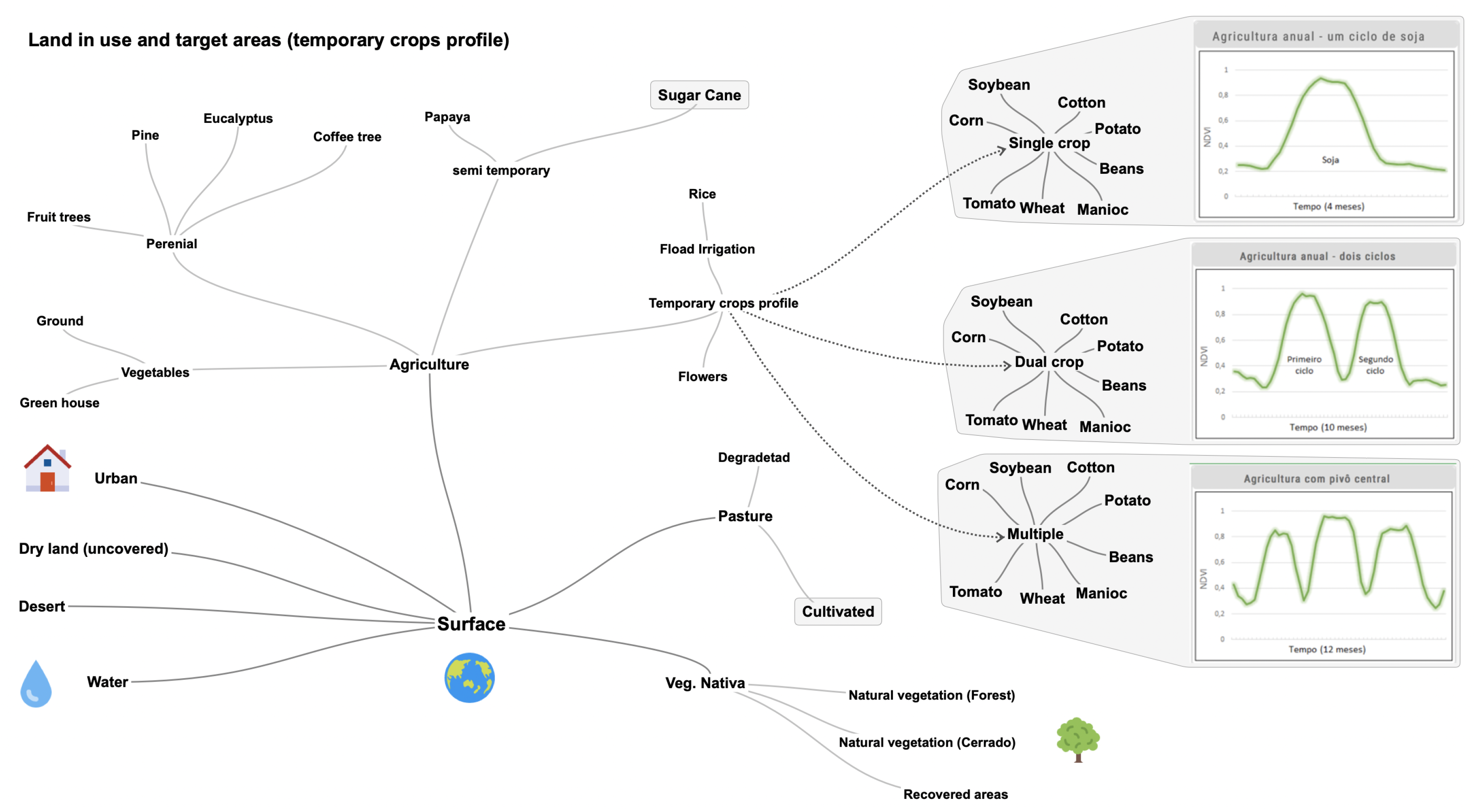
The use of the pixel as a sensor in remote sensing to monitor agriculture cycles requires quality images and fine specs to be granularly classified accordingly to each unique purpose, so unexpected dynamics can be detected and properly managed [
8,
9], (e.g., crop phenology stage, chemicals administration, mechanization, and irrigation management, among others). The critical components for remote sensing are: accurate and current information for training the classifiers; an affordable source of data that qualifies for the specific objective; a storage and processing capacity [
10,
27,
28]. By using MODerate-resolution Imaging Spectrometer (MODIS) products that include the Enhanced Vegetation Index (EVI) [
29], among others, we have access to a complete record of data from each of the Terra and Aqua MODIS sensors, at varying spatial (250 m, 0.05 degree) and temporal (8-day) resolutions validated with accuracies depicted by a pixel reliability flag and with globally averaged uncertainties of 0.015 units. Further, the MODIS/EVI combination is a robust set for exploring seasonal crops (soybeans) [
22]. The spatial resolution adopted are consistent in expressing accurate cropland information in fields that are larger than 20 ha [
13], and appropriate to this task [
30]. This experiment relies on the achievements and specifications above to explore the spectral dynamics of extensive areas, in accordance with the specifics purpose stablished for this research.
1.2. Brazilian Agriculture in Numbers
In Brazil, agriculture represents almost a quarter of the country GDP’s, 24.1% in 2017 [
31]. According to the Brazilian Institute of Geography and Statistics (IBGE) rural census [
32], the harvested area during the 2016/2017 season represented 7.9% of the total area with 73,797,057 hectare (ha) dedicated for temporary and semi-temporary crops and another 5,184,813 ha for permanent crops, with the final results published in 2019. For the purpose of this study, detailed statistics of the studied areas are summarized on the
Table 1. The column “Total” shows the total area (country/State). The column “Agriculture” presents the harvested area (country/State). It is important to highlight that, due to geographical and environmental conditions, which include climate and/or technologies (e.g., irrigation), it is common to have multiple crops per year in tropical areas. Therefore, the conclusion is that the harvests are larger than the total area dedicated to agriculture, a total of 67,547,537 ha according to EMBRAPA [
33,
34] and MAPA [
35].
The main crops cultivated locally are presented below, in
Table 2, and the data is organized as a percentage of total area occupied to provided a land use perspective view, and put in evidence of a larger area per crop cultivated.


