Contribution of Remote Sensing Technologies to a Holistic Coastal and Marine Environmental Management Framework: A Review

 ,
,  ,
,  ,
,
Abstract
:
1. Introduction
2. Materials and Methods
2.1. The DAPSI(W)R(M) Framework
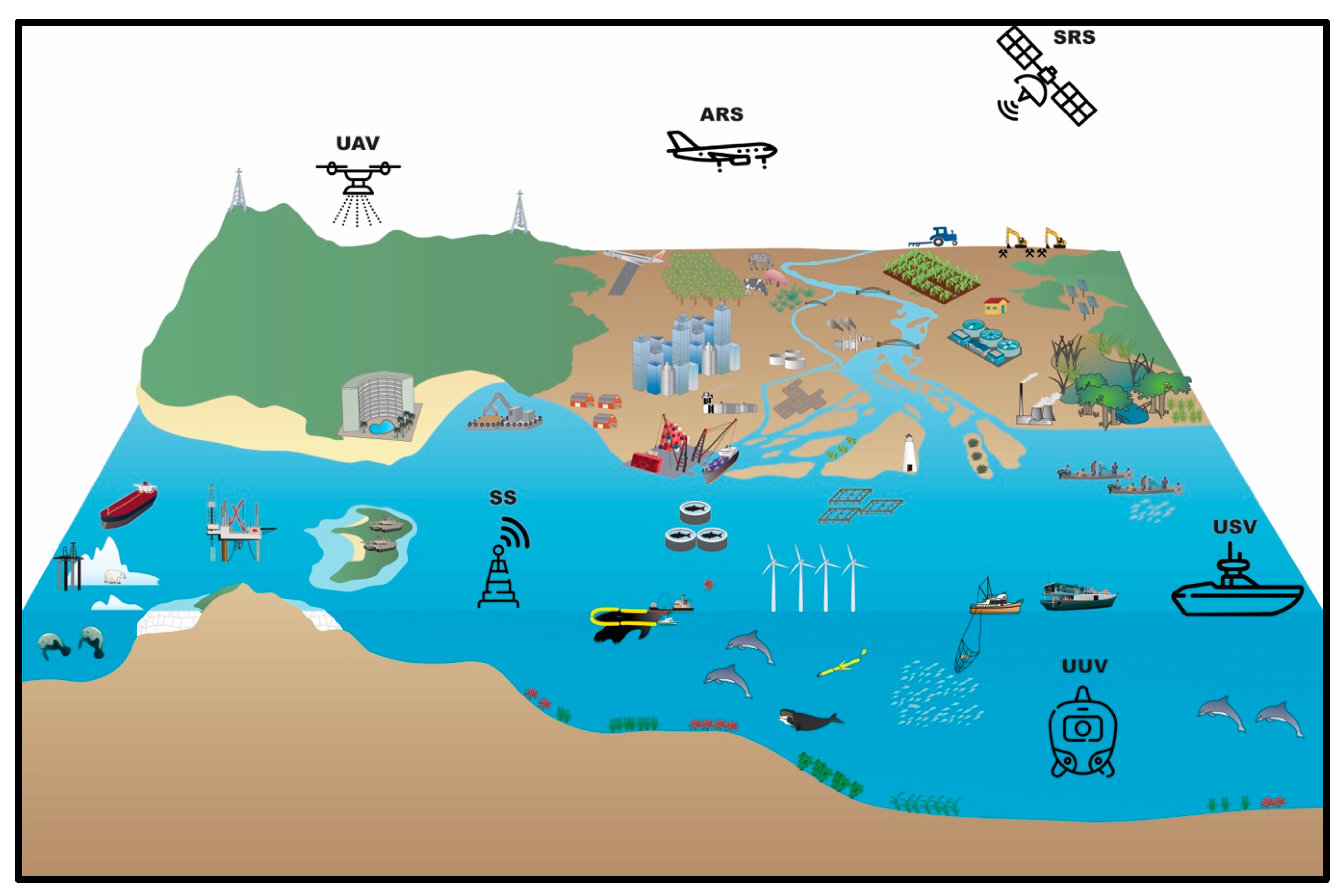
2.2. Remote Sensing Applications that Could be Used for DAPSI(W)R(M) Analysis
3. Results
3.1. RS and Driving Activities
3.1.1. Agriculture
- Coastal Forestry
- Coastal Farming—Greenhouses
3.1.2. Livestock
3.1.3. Golf
3.1.4. Damming
3.1.5. Aquaculture
- Tanks
- Ponds
- Shellfish Culture
3.1.6. Extraction of Living Resources
- Fishing
- Seaweed and Saltmarsh Vegetation Harvesting
3.1.7. Extraction of Non-Living Resources
- Coastal Sand Mining
- Onshore Mineral Extraction
3.1.8. Tourism and Recreation
- Swimming Pools
- Beach Use
- Tourist Resort
3.1.9. Land-Based Industry
- Desalination
3.1.10. Coastal Infrastructure
- Cross-Sea Bridges
- Marinas
- Ports
- Beach Nourishment
3.1.11. Navigational Dredging
3.1.12. Transport and Shipping
3.1.13. Renewable Energy
3.1.14. Non-Renewable Energy
- Fossil Fuels (Oil and Gas)
- Nuclear Power
3.1.15. Carbon Capture and Storage
3.1.16. Marine Archaeology
3.1.17. Land Reclamation
3.1.18. Military
3.2. RS and Pressures
3.2.1. Nutrient Enrichment
3.2.2. Underwater Noise
3.2.3. Death and Injury
3.2.4. Presence of Marine Litter
- General Marine Litter
- Marine Plastic
3.2.5. Substratum Loss
3.2.6. Coastal Erosion
3.2.7. Change in Salinity
3.2.8. Input of Synthetic Compounds: Hydrocarbons
3.2.9. Input of Non-Synthetic Compounds: Toxic Metals
3.2.10. Input of Organic Matter
3.2.11. Input of Radionuclides
3.2.12. Thermal Pollution
3.3. RS and State Changes
3.3.1. Water Quality
3.3.2. Water Turbidity
3.3.3. Suspended Particulate Matter
3.3.4. Coastal and Marine Habitats
- Wetlands
- Mangrove Change
- Seagrass
- Coral Reefs
- Macroalgae
- Vegetation Change
3.3.5. Marine Fauna
- Sea Birds and Marine Mammals
- Turtles
- Sharks
3.3.6. Benthic Environment
3.3.7. Physical Parameter Changes
- Sea Surface Temperature (SST)
- High Wave Exposure
3.3.8. Coastal Landslide
3.3.9. Land Subsidence
3.3.10. Shoreline Changes
3.3.11. Turbidity Plumes
3.3.12. Harmful Algal Blooms
3.3.13. pH Changes
3.4. RS and Impact (on Welfare)
3.4.1. Public Health Risk
3.4.2. Risk to Public Life and Infrastructure
3.5. RS as a Response (as Measure)
4. Discussion
4.1. Limitations of Current Technologies and Challenges
4.1.1. Technology-Based Challenge
4.1.2. Uncertainties
4.1.3. Accessibility and Affordability
4.1.4. Data Storage, Integration, Communication, and Dissemination
4.1.5. Policies and Legal Issues
4.1.6. Fragmented Expertise and Institutions:
4.2. Opportunities for Improving the Integrated Coastal and Marine Environmental Management Framework
5. Conclusions
Author Contributions
Funding
Acknowledgments
Conflicts of Interest
Nomenclature
- Earth observation techniques can be applied for the implementation of environmental directives, such as WFD and MSFD.
- Remote sensing (RS) can be a useful tool for integrated coastal and marine environmental management frameworks.
- An overview of RS uses for an expanded DPSIR framework is presented.
- Challenges, knowledge gaps, and opportunities of RS for DAPSI(W)R(M) are highlighted.
- Emerging earth observation (data acquisition) technologies can help improve environmental understanding for better resource management and attaining SDGs.
References
- Small, C.; Nicholls, R.J. A global analysis of human settlement in coastal zones. J. Coast. Res. 2003, 19, 584–599. [Google Scholar]
- Balk, D.; Montgomery, M.; McGranahan, G.; Kim, D.; Mara, V.; Todd, M.; Buettner, T.; Dorélien, A. Mapping urban settlements and the risks of climate change in Africa, Asia and South America. Popul. Dyn. Clim. Chang. 2009, 80, 103. [Google Scholar]
- He, Q.; Bertness, M.D.; Bruno, J.F.; Li, B.; Chen, G.; Coverdale, T.C.; Altieri, A.H.; Bai, J.; Sun, T.; Pennings, S.C.; et al. Economic development and coastal ecosystem change in China. Sci. Rep. 2014, 4, 5995. [Google Scholar] [CrossRef]
- El Mahrad, B.; Abalansa, S.; Newton, A.; Icely, J.D.; Snoussi, M.; Kacimi, I. Social-environmental analysis for the management of coastal lagoons in North Africa. Front. Environ. Sci. 2020, 8, 37. [Google Scholar] [CrossRef]
- World Resources Institute. Millennium Ecosystem Assessment Ecosystems and Human Well-Being: Biodiversity Synthesis; World Resources Institute: Washington, WA, USA, 2005. [Google Scholar]
- Ostrom, E. A general framework for analyzing sustainability of social-ecological systems. Science 2009, 325, 419–422. [Google Scholar] [CrossRef]
- Elliott, M.; Burdon, D.; Atkins, J.P.; Borja, A.; Cormier, R.; De Jonge, V.N.; Turner, R.K. “And DPSIR begat DAPSI(W)R(M)!”—A unifying framework for marine environmental management. Mar. Pollut. Bull. 2017, 118, 27–40. [Google Scholar] [CrossRef] [PubMed] [Green Version]
- Kennedy, R.E.; Townsend, P.A.; Gross, J.E.; Cohen, W.B.; Bolstad, P.; Wang, Y.Q.; Adams, P. Remote sensing change detection tools for natural resource managers: Understanding concepts and tradeoffs in the design of landscape monitoring projects. Remote Sens. Environ. 2009, 113, 1382–1396. [Google Scholar] [CrossRef]
- Ndzabandzaba, C. Data sharing for sustainable development in less developed and developing countries. Glob. Sustain. Dev. Rep. 2015. Available online: https://wedocs.unep.org/bitstream/handle/20.500.11822/9849/-Global_Sustainable_Development_Report_-_Advanced_Unedited_Version-2015GSDR_2015.pdf.pdf?sequence=3&isAllowed=y (accessed on 30 April 2020).
- Directive, Strategic Environmental Assessment. European Commission Directive 2000/60/EC of the European parliament and of the council of 23 October 2000 establishing a framework for community action in the field of water policy. Off. J. Eur. Communities 2000, 22, 2000. [Google Scholar]
- Directive, Strategy Framework. European Commission Directive 2008/56/EC of the European parliament and of the council of 17 June 2008 establishing a framework for community action in the field of marine environmental policy. Off. J. Eur. Union L 2008, 164, 19–40.
- European Environment Agency. EEA Data Policy Report; København, K., Ed.; European Environment Agency: Copenhagen, Denmark, 2013. [Google Scholar]
- United Nations. Transforming Our World: The 2030 Agenda for Sustainable Development; United Nations: San Francisco, CA, USA, 2015. [Google Scholar]
- United Nations. The Sustainable Development Goals Report 2016; United Nations: San Francisco, CA, USA, 2016. [Google Scholar]
- Halpern, B.S.; Longo, C.; Hardy, D.; McLeod, K.L.; Samhouri, J.F.; Katona, S.K.; Kleisner, K.; Lester, S.E.; O’Leary, J.; Ranelletti, M.; et al. An index to assess the health and benefits of the global ocean. Nature 2012, 488, 615–620. [Google Scholar] [CrossRef] [PubMed] [Green Version]
- Strong, J.A.; Elliott, M. The value of remote sensing techniques in supporting effective extrapolation across multiple marine spatial scales. Mar. Pollut. Bull. 2017, 116, 405–419. [Google Scholar] [CrossRef] [PubMed]
- Cristina, S.; Icely, J.; Goela, P.C.; DelValls, T.A.; Newton, A. Using remote sensing as a support to the implementation of the European Marine Strategy Framework Directive in SW Portugal. Cont. Shelf Res. 2015, 108, 169–177. [Google Scholar] [CrossRef] [Green Version]
- Sanders, K.T.; Masri, S.F. The energy-water agriculture nexus: The past, present and future of holistic resource management via remote sensing technologies. J. Clean. Prod. 2016, 117, 73–88. [Google Scholar] [CrossRef]
- Melesse, A.M.; Weng, Q.; Thenkabail, P.S.; Senay, G.B. Remote sensing sensors and applications in environmental resources mapping and modelling. Sensors 2007, 7, 3209–3241. [Google Scholar] [CrossRef] [PubMed] [Green Version]
- Fingas, M. Remote sensing for marine management. World Seas Environ. Eval. 2019. [Google Scholar] [CrossRef]
- Le Traon, P.Y.; Reppucci, A.; Fanjul, E.A.; Aouf, L.; Behrens, A.; Belmonte, M.; Bentamy, A.; Bertino, L.; Brando, V.E.; Kreiner, M.B.; et al. From observation to information and users: The copernicus marine service perspective. Front. Mar. Sci. 2019, 6, 234. [Google Scholar] [CrossRef] [Green Version]
- Voulvoulis, N.; Burgman, M.A. The contrasting roles of science and technology in environmental challenges. Crit. Rev. Environ. Sci. Technol. 2019, 49, 1079–1106. [Google Scholar] [CrossRef] [Green Version]
- Vihervaara, P.; Auvinen, A.-P.; Mononen, L.; Törmä, M.; Ahlroth, P.; Anttila, S.; Böttcher, K.; Forsius, M.; Heino, J.; Heliölä, J.; et al. How essential biodiversity variables and remote sensing can help national biodiversity monitoring. Glob. Ecol. Conserv. 2017, 10, 43–59. [Google Scholar] [CrossRef]
- Murray, N.J.; Keith, D.A.; Bland, L.M.; Ferrari, R.; Lyons, M.B.; Lucas, R.; Pettorelli, N.; Nicholson, E. The role of satellite remote sensing in structured ecosystem risk assessments. Sci. Total Environ. 2018, 619, 249–257. [Google Scholar] [CrossRef] [Green Version]
- Unninayar, S.; Olsen, L.M. Monitoring, observations, and remote sensing – global dimensions. Ref. Modul. Earth Syst. Environ. Sci. 2015. [Google Scholar] [CrossRef]
- Guo, M.; Li, J.; Sheng, C.; Xu, J.; Wu, L. A Review of wetland remote sensing. Sensors 2017, 17, 777. [Google Scholar] [CrossRef] [PubMed] [Green Version]
- Bean, T.P.; Greenwood, N.; Beckett, R.; Biermann, L.; Bignell, J.P.; Brant, J.L.; Copp, G.H.; Devlin, M.J.; Dye, S.; Feist, S.W.; et al. A Review of the tools used for marine monitoring in the UK: Combining historic and contemporary methods with modeling and socioeconomics to fulfill legislative needs and scientific ambitions. Front. Mar. Sci. 2017, 4, 263. [Google Scholar] [CrossRef] [Green Version]
- Gari, S.R.; Newton, A.; Icely, J.D. A review of the application and evolution of the DPSIR framework with an emphasis on coastal social-ecological systems. Ocean Coast. Manag. 2015, 103, 63–77. [Google Scholar] [CrossRef] [Green Version]
- OECD. Environmental Indicators- OECD Core Set; OECD: Paris, France, 1994; p. 37. [Google Scholar]
- EEA. Europe’s Environment: The Dobris Assessment; Report No 1/1995; European Environmental Agency: Copenhagen, Denmark, 1995; 8p. [Google Scholar]
- Cormier, R.; Elliott, M. Smart marine goals, targets and management—Is SDG 14 operational or aspirational, is ‘Life Below Water’ sinking or swimming? Mar. Pollut. Bull. 2017, 123, 28–33. [Google Scholar] [CrossRef] [PubMed]
- Lovecraft, A.L.; Meek, C.L. Arctic coastal systems: Evaluating the DAPSI(W)R(M) framework. Coasts Estuaries 2019. [Google Scholar] [CrossRef]
- Burdon, D.; Barnard, S.; Boyes, S.J.; Elliott, M. Oil and gas infrastructure decommissioning in marine protected areas: System complexity, analysis and challenges. Mar. Pollut. Bull. 2018, 135, 739–758. [Google Scholar] [CrossRef]
- Kaikkonen, L.; Venesjärvi, R.; Nygård, H.; Kuikka, S. Assessing the impacts of seabed mineral extraction in the deep sea and coastal marine environments: Current methods and recommendations for environmental risk assessment. Mar. Pollut. Bull. 2018, 135, 1183–1197. [Google Scholar] [CrossRef]
- Dale, P.; Sporne, I.; Knight, J.; Sheaves, M.; Eslami-Andergoli, L.; Dwyer, P. A conceptual model to improve links between science, policy and practice in coastal management. Mar. Policy 2019, 103, 42–49. [Google Scholar] [CrossRef]
- Newton, A.; Icely, J.; Cristina, S.; Perillo, G.; Turner, R.E.; Ahsan, D.; Cragg, S.; Luo, Y.L.; Lu, C.; Li, Y.; et al. Anthropogenic pressures on coastal wetlands. Front. Ecol. Evol. 2020, 8, 144. [Google Scholar] [CrossRef]
- Ouellette, W.; Getinet, W. Remote sensing for marine spatial planning and integrated coastal areas management: Achievements, challenges, opportunities and future prospects. Remote Sens. Appl. Soc. Environ. 2016, 4, 138–157. [Google Scholar] [CrossRef]
- Xiao, J.; Chevallier, F.; Gomez, C.; Guanter, L.; Hicke, J.A.; Huete, A.R.; Ichii, K.; Ni, W.; Pang, Y.; Rahman, A.F.; et al. Remote sensing of the terrestrial carbon cycle: A review of advances over 50 years. Remote Sens. Environ. 2019, 233, 111383. [Google Scholar] [CrossRef]
- Side, J.; Jowitt, P. Technologies and their influence on future UK marine resource development and management. Mar. Policy 2002, 26, 231–241. [Google Scholar] [CrossRef]
- Goetz, A.F.H. Three decades of hyperspectral remote sensing of the earth: A personal view. Remote Sens. Environ. 2009, 113, S5–S16. [Google Scholar] [CrossRef]
- Kratzer, S.; Therese Harvey, E.; Philipson, P. The use of ocean color remote sensing in integrated coastal zone management—A case study from Himmerfjärden, Sweden. Mar. Policy 2014, 43, 29–39. [Google Scholar] [CrossRef]
- Neukermans, G.; Harmel, T.; Galí, M.; Rudorff, N.; Chowdhary, J.; Dubovik, O.; Hostetler, C.; Hu, Y.; Jamet, C.; Knobelspiesse, K.; et al. Harnessing remote sensing to address critical science questions on ocean-atmosphere interactions. Elementa 2018, 6. [Google Scholar] [CrossRef]
- Werdell, P.J.; McKinna, L.I.W.; Boss, E.; Ackleson, S.G.; Craig, S.E.; Gregg, W.W.; Lee, Z.; Maritorena, S.; Roesler, C.S.; Rousseaux, C.S.; et al. An overview of approaches and challenges for retrieving marine inherent optical properties from ocean color remote sensing. Prog. Oceanogr. 2018, 160, 186–212. [Google Scholar] [CrossRef]
- Krug, L.A.; Platt, T.; Sathyendranath, S.; Barbosa, A.B. Ocean surface partitioning strategies using ocean colour remote sensing: A review. Prog. Oceanogr. 2017, 155, 41–53. [Google Scholar] [CrossRef]
- Toth, C.; Jóźków, G. Remote sensing platforms and sensors: A survey. ISPRS J. Photogramm. Remote Sens. 2016, 115, 22–36. [Google Scholar] [CrossRef]
- Zhu, L.; Suomalainen, J.; Liu, J.; Hyyppä, J.; Kaartinen, H.; Haggren, H. A review: Remote sensing sensors. In Multi-Purposeful Application of Geospatial Data; InTechOpen: Rijeka, Croatia, 2018. [Google Scholar] [CrossRef] [Green Version]
- Skoog, A.I. The Alfred Nobel rocket camera. An early aerial photography attempt. Acta Astronaut. 2010, 66, 624–635. [Google Scholar] [CrossRef]
- Gorman, L.; Morang, A.; Larson, R. Monitoring the coastal environment; Part IV: Mapping, shoreline changes, and bathymetric analysis. J. Coast. Res. 1998, 14, 61–92. [Google Scholar]
- Niaounakis, M. Assessment. In Management of Marine Plastic Debris; Elsevier: Amsterdam, The Netherlands, 2017; pp. 143–214. ISBN 978-0-323-44354-8. [Google Scholar]
- Yang, J.; Artigas, F.J. Mapping Salt Marsh Vegetation by Integrating Hyperspectral and LiDAR Remote Sensing; CRC Press: Boca Raton, FL, USA, 2009; pp. 173–187. [Google Scholar]
- Klemas, V. Airborne remote sensing of coastal features and processes: An overview. J. Coast. Res. 2012. [Google Scholar] [CrossRef]
- Purkis, S.J.; Klemas, V.V. Remote Sensing and Global Environmental Change; John Wiley & Sons: Hoboken, NJ, USA, 2011; ISBN 1444340255. [Google Scholar] [CrossRef]
- Pereira, E.; Bencatel, R.; Correia, J.; Félix, L.; Gonçalves, G.; Morgado, J.; Sousa, J. Unmanned air vehicles for coastal and environmental research. J. Coast. Res. 2009, II, 1557–1561. [Google Scholar]
- Klemas, V.V. Coastal and environmental remote sensing from unmanned aerial vehicles: An overview. J. Coast. Res. 2015. [Google Scholar] [CrossRef] [Green Version]
- Murfitt, S.L.; Allan, B.M.; Bellgrove, A.; Rattray, A.; Young, M.A.; Ierodiaconou, D. Applications of unmanned aerial vehicles in intertidal reef monitoring. Sci. Rep. 2017, 7, 10259. [Google Scholar] [CrossRef] [PubMed] [Green Version]
- Colefax, A.P.; Butcher, P.A.; Kelaher, B.P. The potential for unmanned aerial vehicles (UAVs) to conduct marine fauna surveys in place of manned aircraft. Ices J. Mar. Sci. 2017, 75, 1–8. [Google Scholar] [CrossRef]
- Torres, L.G.; Nieukirk, S.L.; Lemos, L.; Chandler, T.E. Drone up! Quantifying whale behavior from a new perspective improves observational capacity. Front. Mar. Sci. 2018, 5, 319. [Google Scholar] [CrossRef] [Green Version]
- Papakonstantinou, A.; Topouzelis, K.; Pavlogeorgatos, G. Coastline zones identification and 3D coastal mapping using UAV spatial data. ISPRS Int. J. Geo. Inf. 2016, 5, 75. [Google Scholar] [CrossRef] [Green Version]
- Doukari, M.; Batsaris, M.; Papakonstantinou, A.; Topouzelis, K. A Protocol for aerial survey in coastal areas using UAS. Remote Sens. 2019, 11, 1913. [Google Scholar] [CrossRef] [Green Version]
- Colomina, I.; Molina, P. Unmanned aerial systems for photogrammetry and remote sensing: A review. ISPRS J. Photogramm. Remote Sens. 2014, 92, 79–97. [Google Scholar] [CrossRef] [Green Version]
- Manley, J.E. Unmanned surface vehicles, 15 years of development. In Proceedings of the OCEANS IEEE 2008, Quebec, QC, Canada, 8–11 April 2008; Volume 2008, pp. 1–4. [Google Scholar]
- Duarte, M.; Costa, V.; Gomes, J.; Rodrigues, T.; Silva, F.; Oliveira, S.M.; Christensen, A.L. Evolution of collective behaviors for a real swarm of aquatic surface robots. PLoS ONE 2016, 11, e0151834. [Google Scholar] [CrossRef] [PubMed]
- Roberts, G.N.; Sutton, R. Advances in Unmanned Marine Vehicles; Roberts, G.N., Sutton, R., Eds.; IET The Institution of Engineering and Technology: Stevenage, UK, 2006; Volume 69, ISBN 9780863414503. [Google Scholar]
- Caccia, M.; Bono, R.; Bruzzone, G.; Spirandelli, E.; Veruggio, G.; Stortini, A.M.; Capodaglio, G. Sampling sea surfaces with SESAMO: An autonomous craft for the study of sea-air interactions. IEEE Robot. Autom. Mag. 2005, 12, 95–105. [Google Scholar] [CrossRef]
- Naeem, W.; Xu, T.; Sutton, R.; Tiano, A. The design of a navigation, guidance, and control system for an unmanned surface vehicle for environmental monitoring. Proc. Inst. Mech. Eng. Part M J. Eng. Marit. Environ. 2008, 222, 67–79. [Google Scholar] [CrossRef] [Green Version]
- Švec, P.; Thakur, A.; Raboin, E.; Shah, B.C.; Gupta, S.K. Target following with motion prediction for unmanned surface vehicle operating in cluttered environments. Auton. Robot. 2014, 36, 383–405. [Google Scholar] [CrossRef]
- Leong, S.C.Y.; Tkalich, P.; Patrikalakis, N.M. Monitoring harmful algal blooms in Singapore: Developing a HABs observing system. In Proceedings of the 2012 Oceans—Yeosu IEEE, Yeosu, Korea, 21–24 May 2012; pp. 1–5. [Google Scholar]
- Meyer, D. Glider technology for ocean observations: A Review. Ocean Sci. Discuss. 2016, 2016, 1–26. [Google Scholar] [CrossRef]
- Ryan, J.P.; Johnson, S.B.; Sherman, A.; Rajan, K.; Py, F.; Thomas, H.; Harvey, J.B.J.; Bird, L.; Paduan, J.D.; Vrijenhoek, R.C. Mobile autonomous process sampling within coastal ocean observing systems. Limnol. Oceanogr. Methods 2010, 8, 394–402. [Google Scholar] [CrossRef]
- Verfuss, U.K.; Aniceto, A.S.; Harris, D.V.; Gillespie, D.; Fielding, S.; Jiménez, G.; Johnston, P.; Sinclair, R.R.; Sivertsen, A.; Solbø, S.A.; et al. A review of unmanned vehicles for the detection and monitoring of marine fauna. Mar. Pollut. Bull. 2019, 140, 17–29. [Google Scholar] [CrossRef]
- Liu, Z.; Zhang, Y.; Yu, X.; Yuan, C. Unmanned surface vehicles: An overview of developments and challenges. Annu. Rev. Control 2016, 41, 71–93. [Google Scholar] [CrossRef]
- Wynn, R.B.; Huvenne, V.A.I.; Le Bas, T.P.; Murton, B.J.; Connelly, D.P.; Bett, B.J.; Ruhl, H.A.; Morris, K.J.; Peakall, J.; Parsons, D.R.; et al. Autonomous Underwater Vehicles (AUVs): Their past, present and future contributions to the advancement of marine geoscience. Mar. Geol. 2014, 352, 451–468. [Google Scholar] [CrossRef] [Green Version]
- Marre, G.; Holon, F.; Luque, S.; Boissery, P.; Deter, J. Monitoring marine habitats with photogrammetry: A cost-effective, accurate, precise and high-resolution reconstruction method. Front. Mar. Sci. 2019, 6, 276. [Google Scholar] [CrossRef]
- Katzschmann, R.K.; DelPreto, J.; MacCurdy, R.; Rus, D. Exploration of underwater life with an acoustically controlled soft robotic fish. Sci. Robot. 2018, 3. [Google Scholar] [CrossRef] [Green Version]
- Thompson, D.; Caress, D.; Paull, C.; Clague, D.; Thomas, H.; Conlin, D. MBARI mapping AUV operations: In the gulf of California. In Proceedings of the 2012 Oceans IEEE, Hampton Roads, VA, USA, 14–19 October 2012; pp. 1–5. [Google Scholar] [CrossRef]
- Allotta, B.; Costanzi, R.; Ridolfi, A.; Colombo, C.; Bellavia, F.; Fanfani, M.; Pazzaglia, F.; Salvetti, O.; Moroni, D.; Pascali, M.A.; et al. The ARROWS project: Adapting and developing robotics technologies for underwater archaeology. IFAC Pap. 2015, 48, 194–199. [Google Scholar] [CrossRef]
- Jacobi, M. Autonomous inspection of underwater structures. Robot. Auton. Syst. 2015, 67, 80–86. [Google Scholar] [CrossRef]
- Sahoo, A.; Dwivedy, S.K.; Robi, P.S. Advancements in the field of autonomous underwater vehicle. Ocean Eng. 2019, 181, 145–160. [Google Scholar] [CrossRef]
- Hu, S.; Wang, H.; Liu, Z.; Wang, Y. Design of a three-dimensional current sensor with measuring upwelling. Flow Meas. Instrum. 2019, 69, 101606. [Google Scholar] [CrossRef]
- Parra, L.; Sendra, S.; García, L.; Lloret, J. Design and deployment of low-cost sensors for monitoring the water quality and fish behavior in aquaculture tanks during the feeding process. Sensors 2018, 18, 750. [Google Scholar] [CrossRef] [Green Version]
- Barbariol, F.; Benetazzo, A.; Bertotti, L.; Cavaleri, L.; Durrant, T.; McComb, P.; Sclavo, M. Large waves and drifting buoys in the Southern Ocean. Ocean Eng. 2019, 172, 817–828. [Google Scholar] [CrossRef] [Green Version]
- Justino, C.I.L.; Freitas, A.C.; Duarte, A.C.; Santos, T.A. Sensors and biosensors for monitoring marine contaminants. Trends Environ. Anal. Chem. 2015, 6–7, 21–30. [Google Scholar] [CrossRef]
- Venkatesan, R.; Ramesh, K.; Kishor, A.; Vedachalam, N.; Atmanand, M.A. Best practices for the ocean moored observatories. Front. Mar. Sci. 2018, 5, 469. [Google Scholar] [CrossRef] [Green Version]
- McClain, C.R. A Decade of satellite ocean color observations. Ann. Rev. Mar. Sci. 2009, 1, 19–42. [Google Scholar] [CrossRef] [Green Version]
- Fretwell, P.T.; Phillips, R.A.; Brooke, M.D.; Fleming, A.H.; McArthur, A. Using the unique spectral signature of guano to identify unknown seabird colonies. Remote Sens. Environ. 2015, 156, 448–456. [Google Scholar] [CrossRef] [Green Version]
- Jutz, S.; Milagro-Pérez, M.P. Copernicus program. Compr. Remote Sens. 2018. [Google Scholar] [CrossRef]
- Yang, D.; Chen, J.; Zhou, Y.; Chen, X.; Chen, X.; Cao, X. Mapping plastic greenhouse with medium spatial resolution satellite data: Development of a new spectral index. ISPRS J. Photogramm. Remote Sens. 2017, 128, 47–60. [Google Scholar] [CrossRef]
- Aguilar, M.; Vallario, A.; Aguilar, F.; Lorca, A.; Parente, C. Object-based greenhouse horticultural crop identification from multi-temporal satellite imagery: A case study in Almeria, Spain. Remote Sens. 2015, 7, 7378–7401. [Google Scholar] [CrossRef] [Green Version]
- Wang, D.; Cui, Q.; Gong, F.; Wang, L.; He, X.; Bai, Y. Satellite retrieval of surface water nutrients in the coastal regions of the east China sea. Remote Sens. 2018, 10, 1896. [Google Scholar] [CrossRef] [Green Version]
- Blondeau-Patissier, D.; Gower, J.F.R.; Dekker, A.G.; Phinn, S.R.; Brando, V.E. A review of ocean color remote sensing methods and statistical techniques for the detection, mapping and analysis of phytoplankton blooms in coastal and open oceans. Prog. Oceanogr. 2014, 123, 123–144. [Google Scholar] [CrossRef] [Green Version]
- Corgne, S.; Hubert-Moy, L.; Betbeder, J. Monitoring of agricultural landscapes using remote sensing data. L. Surf. Remote Sens. Agric. For. 2016. [Google Scholar] [CrossRef]
- Liu, C.; Chen, Z.; Shao, Y.; Chen, J.; Hasi, T.; Pan, H. Research advances of SAR remote sensing for agriculture applications: A review. J. Integr. Agric. 2019, 18, 506–525. [Google Scholar] [CrossRef] [Green Version]
- Fritz, S.; See, L.; Bayas, J.C.L.; Waldner, F.; Jacques, D.; Becker-Reshef, I.; Whitcraft, A.; Baruth, B.; Bonifacio, R.; Crutchfield, J.; et al. A comparison of global agricultural monitoring systems and current gaps. Agric. Syst. 2019, 168, 258–272. [Google Scholar] [CrossRef]
- Beitl, C.M.; Rahimzadeh-Bajgiran, P.; Bravo, M.; Ortega-Pacheco, D.; Bird, K. New valuation for defying degradation: Visualizing mangrove forest dynamics and local stewardship with remote sensing in coastal Ecuador. Geoforum 2019, 98, 123–132. [Google Scholar] [CrossRef]
- Kellenberger, B.; Marcos, D.; Tuia, D. Detecting mammals in UAV images: Best practices to address a substantially imbalanced dataset with deep learning. Remote Sens. Environ. 2018, 216, 139–153. [Google Scholar] [CrossRef] [Green Version]
- Chen, J.; Wang, C.; He, D.; Chen, J.; Yue, A. Practical Bottom-Up Golf Course Detection Using Multispectral Remote Sensing Imagery; Zhao, Y., Kong, X., Taubman, D., Eds.; Springer International Publishing: Cham, Switzerland, 2017; pp. 552–559. ISBN 978-3-319-71589-6. [Google Scholar]
- Karamvasis, K.; Karathanassi, V. Deformation effects of dams on coastal regions using sentinel-1 iw tops time series: The west Lesvos, Greece case. ISPRS Int. Arch. Photogramm. Remote Sens. Spat. Inf. Sci. 2017. [Google Scholar] [CrossRef] [Green Version]
- Ottinger, M.; Clauss, K.; Kuenzer, C. Aquaculture: Relevance, distribution, impacts and spatial assessments—A review. Ocean Coast. Manag. 2016, 119, 244–266. [Google Scholar] [CrossRef]
- Bao, J.; Li, D.; Qiao, X.; Rauschenbach, T. Integrated navigation for autonomous underwater vehicles in aquaculture: A review. Inf. Process. Agric. 2019. [Google Scholar] [CrossRef]
- Ren, C.; Wang, Z.; Zhang, B.; Li, L.; Chen, L.; Song, K.; Jia, M. Remote monitoring of expansion of aquaculture ponds along coastal region of the Yellow River Delta from 1983 to 2015. Chin. Geogr. Sci. 2018, 28, 430–442. [Google Scholar] [CrossRef] [Green Version]
- Le Bris, A.; Rosa, P.; Lerouxel, A.; Cognie, B.; Gernez, P.; Launeau, P.; Robin, M.; Barillé, L. Hyperspectral remote sensing of wild oyster reefs. Estuar. Coast. Shelf Sci. 2016, 172, 1–12. [Google Scholar] [CrossRef]
- Klemas, V. Fisheries applications of remote sensing: An overview. Fish. Res. 2013, 148, 124–136. [Google Scholar] [CrossRef]
- Heumann, B.W.; Hackett, R.A.; Monfils, A.K.; Gross, J.W. The Remote sensing of biodiversity: From global to local scales. Compr. Remote Sens. 2018. [Google Scholar] [CrossRef]
- Chaussard, E.; Kerosky, S. Characterization of black sand mining activities and their environmental impacts in the philippines using remote sensing. Remote Sens. 2016, 8, 100. [Google Scholar] [CrossRef] [Green Version]
- Werner, T.T.; Bebbington, A.; Gregory, G. Assessing impacts of mining: Recent contributions from GIS and remote sensing. Extr. Ind. Soc. 2019, 6, 993–1012. [Google Scholar] [CrossRef]
- Miller, M.L.; Lieske, S.N.; Carter, R.W.; Walsh, S.J. Understanding the interaction between a protected destination system and conservation tourism through remote sensing. Compr. Remote Sens. 2018. [Google Scholar] [CrossRef]
- Wolf, N.; Hof, A. Integrating machine learning techniques and high-resolution imagery to generate GIS-ready information for urban water consumption studies. In Proceedings of the Earth Resources and Environmental Remote Sensing/GIS Applications III 2012, Edinburgh, UK, 25 October 2012; Volume 8538. [Google Scholar]
- Llausàs, A.; Hof, A.; Wolf, N.; Saurí, D.; Siegmund, A. Applicability of cadastral data to support the estimation of water use in private swimming pools. Environ. Plan. B Urban Anal. City Sci. 2018, 46, 1165–1181. [Google Scholar] [CrossRef]
- Cabezas-Rabadán, C.; Pardo-Pascual, J.E.; Almonacid-Caballer, J.; Rodilla, M. Detecting problematic beach widths for the recreational function along the Gulf of Valencia (Spain) from Landsat 8 subpixel shorelines. Appl. Geogr. 2019, 110, 102047. [Google Scholar] [CrossRef]
- Cabezas-Rabadán, C.; Pardo-Pascual, J.E.; Palomar-Vázquez, J.; Fernández-Sarría, A. Characterizing beach changes using high-frequency Sentinel-2 derived shorelines on the Valencian coast (Spanish Mediterranean). Sci. Total Environ. 2019, 691, 216–231. [Google Scholar] [CrossRef] [PubMed]
- Chen, B.; Yang, Y.; Wen, H.; Ruan, H.; Zhou, Z.; Luo, K.; Zhong, F. High-resolution monitoring of beach topography and its change using unmanned aerial vehicle imagery. Ocean Coast. Manag. 2018, 160, 103–116. [Google Scholar] [CrossRef]
- Sung, C.Y.; Cho, W.; Hong, S.-H. Estimating the annual carbon budget of a weekend tourist resort in a temperate secondary forest in Korea. Urban For. Urban Green. 2015, 14, 413–419. [Google Scholar] [CrossRef]
- Al Shehhi, M.R.; Gherboudj, I.; Ghedira, H. Satellites-based monitoring of harmful algal blooms for sustainable desalination. In Desalination Sustainability; Elsevier: Amsterdam, The Netherlands, 2017; pp. 341–366. ISBN 9780128098967. [Google Scholar]
- Al Muhairi, A.; Ghedira, H.; Al-Ahmad, H.; Dawood, A.; Al-Mualla, M. Exploring the potential of MODIS visible and thermal channels in monitoring and assessing the impact of desalination plant discharges in the Arabian Gulf. In Proceedings of the 2009 IEEE International Geoscience and Remote Sensing Symposium, Cape Town, South Africa, 12–17 July 2009; Volume 3, pp. 357–360. [Google Scholar]
- Yuan, Y.; Jalón-Rojas, I.; Wang, X.H. Impact of coastal infrastructure on ocean colour remote sensing: A case study in Jiaozhou Bay, China. Remote Sens. 2019, 11, 946. [Google Scholar] [CrossRef] [Green Version]
- Klein, M.; Zviely, D. The environmental impact of marina development on adjacent beaches: A case study of the Herzliya marina, Israel. Appl. Geogr. 2001, 21, 145–156. [Google Scholar] [CrossRef]
- Merico, E.; Dinoi, A.; Contini, D. Development of an integrated modelling-measurement system for near-real-time estimates of harbour activity impact to atmospheric pollution in coastal cities. Transp. Res. Part D Transp. Environ. 2019, 73, 108–119. [Google Scholar] [CrossRef]
- Hellweger, F.L.; Schlosser, P.; Lall, U.; Weissel, J.K. Use of satellite imagery for water quality studies in New York Harbor. Estuar. Coast. Shelf Sci. 2004, 61, 437–448. [Google Scholar] [CrossRef]
- Gracia, V.; Sierra, J.P.; Gómez, M.; Pedrol, M.; Sampé, S.; García-León, M.; Gironella, X. Assessing the impact of sea level rise on port operability using LiDAR-derived digital elevation models. Remote Sens. Environ. 2019, 232, 111318. [Google Scholar] [CrossRef]
- Vos, K.; Harley, M.D.; Splinter, K.D.; Simmons, J.A.; Turner, I.L. Sub-annual to multi-decadal shoreline variability from publicly available satellite imagery. Coast. Eng. 2019, 150, 160–174. [Google Scholar] [CrossRef]
- Caballero, I.; Navarro, G.; Ruiz, J. Multi-platform assessment of turbidity plumes during dredging operations in a major estuarine system. Int. J. Appl. Earth Obs. Geoinf. 2018, 68, 31–41. [Google Scholar] [CrossRef]
- Kanjir, U.; Greidanus, H.; Oštir, K. Vessel detection and classification from spaceborne optical images: A literature survey. Remote Sens. Environ. 2018, 207, 1–26. [Google Scholar] [CrossRef] [PubMed]
- Xiao, C.; Sun, D.; Wang, S.; Qiu, Z.; Huan, Y.; Zhang, J. Long-term changes in colored dissolved organic matter from satellite observations in the Bohai Sea and North Yellow Sea. Remote Sens. 2018, 10, 688. [Google Scholar] [CrossRef] [Green Version]
- Hasager, C.B. Offshore winds mapped from satellite remote sensing. Wiley Interdiscip. Rev. Energy Environ. 2014, 3, 594–603. [Google Scholar] [CrossRef] [Green Version]
- Shukla, A.; Karki, H. Application of robotics in offshore oil and gas industry—A review Part II. Robot. Auton. Syst. 2016, 75, 508–524. [Google Scholar] [CrossRef]
- Liu, Y.; Hu, C.; Sun, C.; Zhan, W.; Sun, S.; Xu, B.; Dong, Y. Assessment of offshore oil/gas platform status in the northern Gulf of Mexico using multi-source satellite time-series images. Remote Sens. Environ. 2018, 208, 63–81. [Google Scholar] [CrossRef]
- Dai, X.; Guo, Z.; Lin, Y.; Wei, C.; Ye, S. Application of satellite remote sensing data for monitoring thermal discharge pollution from Tianwan nuclear power plant in eastern China. In Proceedings of the 2012 5th International Congress on Image and Signal Processing IEEE, Chongqing, China, 16–18 October 2012; pp. 1019–1023. [Google Scholar]
- Litynski, J.; Vikara, D.; Webster, M.; Srivastava, R.U.S. Department of energy efforts to advance remote sensing technologies for monitoring geologic storage operations. Energy Procedia 2013, 37, 4114–4127. [Google Scholar] [CrossRef] [Green Version]
- Luo, L.; Wang, X.; Guo, H.; Lasaponara, R.; Zong, X.; Masini, N.; Wang, G.; Shi, P.; Khatteli, H.; Chen, F.; et al. Airborne and spaceborne remote sensing for archaeological and cultural heritage applications: A review of the century (1907–2017). Remote Sens. Environ. 2019, 232, 111280. [Google Scholar] [CrossRef]
- Erten, E.; Rossi, C. The worsening impacts of land reclamation assessed with Sentinel-1: The Rize (Turkey) test case. Int. J. Appl. Earth Obs. Geoinf. 2019, 74, 57–64. [Google Scholar] [CrossRef]
- Smith, L.; Cornillon, P.; Rudnickas, D.; Mouw, C.B. Evidence of Environmental changes caused by Chinese island-building. Sci. Rep. 2019, 9, 5295. [Google Scholar] [CrossRef] [PubMed]
- Beck, A.J.; Gledhill, M.; Schlosser, C.; Stamer, B.; Böttcher, C.; Sternheim, J.; Greinert, J.; Achterberg, E.P. Spread, behavior, and ecosystem consequences of conventional munitions compounds in coastal marine waters. Front. Mar. Sci. 2018, 5, 141. [Google Scholar] [CrossRef] [Green Version]
- Campbell, B.M.; Beare, D.J.; Bennett, E.M.; Hall-Spencer, J.M.; Ingram, J.S.I.; Jaramillo, F.; Ortiz, R.; Ramankutty, N.; Sayer, J.A.; Shindell, D. Agriculture production as a major driver of the Earth system exceeding planetary boundaries. Ecol. Soc. 2017, 22. [Google Scholar] [CrossRef]
- Huang, Y.; Chen, Z.; Yu, T.; Huang, X.; Gu, X. Agricultural remote sensing big data: Management and applications. J. Integr. Agric. 2018, 17, 1915–1931. [Google Scholar] [CrossRef]
- Mattsson, E.; Ostwald, M.; Nissanka, S.P.; Holmer, B.; Palm, M. Recovery and protection of coastal ecosystems after tsunami event and potential for participatory forestry CDM—Examples from Sri Lanka. Ocean Coast. Manag. 2009, 52, 1–9. [Google Scholar] [CrossRef]
- Salgot, M.; Tapias, J.C. Golf courses: Environmental impacts. Tour. Hosp. Res. 2006, 6, 218–226. [Google Scholar] [CrossRef]
- Syvitski, J.P.M.; Kettner, A. Sediment flux and the Anthropocene. Philos. Trans. R. Soc. A Math. Phys. Eng. Sci. 2011, 369, 957–975. [Google Scholar] [CrossRef]
- Milliman, J.D. Blessed dams or damned dams? Nature 1997, 386, 325–327. [Google Scholar] [CrossRef]
- Ezcurra, E.; Barrios, E.; Ezcurra, P.; Ezcurra, A.; Vanderplank, S.; Vidal, O.; Villanueva-Almanza, L.; Aburto-Oropeza, O. A natural experiment reveals the impact of hydroelectric dams on the estuaries of tropical rivers. Sci. Adv. 2019, 5. [Google Scholar] [CrossRef] [Green Version]
- FAO. The State of World Fisheries and Aquaculture 2018—Meeting the Sustainable Development Goals; FAO: Rome, Italy, 2018. [Google Scholar]
- EU. Report on the Blue Growth Strategy—Towards More Sustainable Growth and Jobs in the Blue Economy; European Union: Brussels, Belgium, 2017. [Google Scholar]
- Singh, S.; Parida, B. Satellite-based identification of aquaculture farming over coastal areas around Bhitarkanika, Odisha using a neural network method. Proceedings 2018, 2, 331. [Google Scholar] [CrossRef] [Green Version]
- Bostock, J.; McAndrew, B.; Richards, R.; Jauncey, K.; Telfer, T.; Lorenzen, K.; Little, D.; Ross, L.; Handisyde, N.; Gatward, I.; et al. Aquaculture: Global status and trends. Philos. Trans. R. Soc. B Biol. Sci. 2010, 365, 2897–2912. [Google Scholar] [CrossRef]
- Troell, M.; Kautsky, N.; Beveridge, M.; Henriksson, P.; Primavera, J.; Rönnbäck, P.; Folke, C. Aquaculture. Encycl. Biodivers. 2013. [Google Scholar] [CrossRef]
- Espmark, Å.M.; Kolarevic, J.; Åsgård, T.; Terjesen, B.F. Tank size and fish management history matters in experimental design. Aquac. Res. 2017, 48, 2876–2894. [Google Scholar] [CrossRef] [Green Version]
- Prasad, K.; Ottinger, M.; Wei, C.; Leinenkugel, P. Assessment of coastal aquaculture for india from sentinel-1 SAR time series. Remote Sens. 2019, 11, 357. [Google Scholar] [CrossRef] [Green Version]
- Laurs, R.M.; Foley, D.; Musyl, M. Identification of large pelagic marine fish habitats and habitat utilization using ‘pop-up’ satellite archival tag and oceanic satellite remote sensing technologies and ‘SODA’ simple ocean data simulation model analyses. In Proceedings of the 2006 IEEE US/EU Baltic International Symposium, Klaipeda, Lithuania, 23–26 May 2006; pp. 1–9. [Google Scholar]
- Elvidge, C.D.; Ghosh, T.; Baugh, K.; Zhizhin, M.; Hsu, F.-C.; Katada, N.S.; Penalosa, W.; Hung, B.Q. Rating the effectiveness of fishery closures with visible infrared imaging radiometer suite boat detection data. Front. Mar. Sci. 2018, 5, 132. [Google Scholar] [CrossRef]
- Jonah, F.E.; Adjei-Boateng, D.; Agbo, N.W.; Mensah, E.A.; Edziyie, R.E. Assessment of sand and stone mining along the coastline of Cape Coast, Ghana. Ann. Gis. 2015, 21, 223–231. [Google Scholar] [CrossRef] [Green Version]
- Jackson, N.L.; Nordstrom, K.F. Trends in research on beaches and dunes on sandy shores, 1969–2019. Geomorphology 2019. [Google Scholar] [CrossRef]
- Prodger, S.; Russell, P.; Davidson, M.; Miles, J.; Scott, T. Understanding and predicting the temporal variability of sediment grain size characteristics on high-energy beaches. Mar. Geol. 2016, 376, 109–117. [Google Scholar] [CrossRef] [Green Version]
- Palmer, A.; Mathel, V. Causes and consequences of underutilised capacity in a tourist resort development. Tour. Manag. 2010, 31, 925–935. [Google Scholar] [CrossRef]
- Anderson, D.M.; Boerlage, S.F.E.; Dixon, M.B. Harmful Algal Blooms (HABs) and desalination: A Guide to impacts, monitoring, and management. Filtr. Ind. Anal. 2017, 2017, 4. [Google Scholar] [CrossRef]
- Trees, C.C.; Bissett, P.W.; Dierssen, H.; Kohler, D.D.R.; Moline, M.A.; Mueller, J.L.; Pieper, R.E.; Twardowski, M.S.; Zaneveld, J.R.V. Monitoring water transparency and diver visibility in ports and harbors using aircraft hyperspectral remote sensing. In Proceedings of the SPIE, Photonics for port and Harbor Security, Orlando, FL, USA, 19 May 2005; Volume 5780, p. 91. [Google Scholar] [CrossRef] [Green Version]
- Danovaro, R.; Nepote, E.; Martire, M.L.; Ciotti, C.; De Grandis, G.; Corinaldesi, C.; Carugati, L.; Cerrano, C.; Pica, D.; Di Camillo, C.G.; et al. Limited impact of beach nourishment on macrofaunal recruitment/settlement in a site of community interest in coastal area of the Adriatic Sea (Mediterranean Sea). Mar. Pollut. Bull. 2018, 128, 259–266. [Google Scholar] [CrossRef] [PubMed]
- Semeoshenkova, V.; Newton, A. Overview of erosion and beach quality issues in three Southern European countries: Portugal, Spain and Italy. Ocean Coast. Manag. 2015, 118, 12–21. [Google Scholar] [CrossRef]
- Pranzini, E.; Anfuso, G.; Botero, C.-M.; Cabrera, A.; Apin Campos, Y.; Casas Martinez, G.; Williams, A.T. Sand colour at Cuba and its influence on beach nourishment and management. Ocean Coast. Manag. 2016, 126, 51–60. [Google Scholar] [CrossRef]
- Erftemeijer, P.L.A.; Riegl, B.; Hoeksema, B.W.; Todd, P.A. Environmental impacts of dredging and other sediment disturbances on corals: A review. Mar. Pollut. Bull. 2012, 64, 1737–1765. [Google Scholar] [CrossRef] [PubMed]
- An, H.; Choi, S.; Lee, J.H. Integrated scheduling of vessel dispatching and port operations in the closed-loop shipping system for transporting petrochemicals. Comput. Chem. Eng. 2019, 126, 485–498. [Google Scholar] [CrossRef]
- Weiss, C.V.C.; Guanche, R.; Ondiviela, B.; Castellanos, O.F.; Juanes, J. Marine renewable energy potential: A global perspective for offshore wind and wave exploitation. Energy Convers. Manag. 2018, 177, 43–54. [Google Scholar] [CrossRef]
- Calaudi, R.; Feudo, T.L.; Calidonna, C.R.; Sempreviva, A.M. Using remote sensing data for integrating different renewable energy sources at coastal site in south Italy. Energy Procedia 2016, 97, 172–178. [Google Scholar] [CrossRef] [Green Version]
- Schwanitz, V.J.; Wierling, A.; Shah, P. Assessing the impact of renewable energy on regional sustainability—A comparative study of Sogn og Fjordane (Norway) and Okinawa (Japan). Sustainability 2017, 9, 1969. [Google Scholar] [CrossRef] [Green Version]
- Necci, A.; Tarantola, S.; Vamanu, B.; Krausmann, E.; Ponte, L. Lessons learned from offshore oil and gas incidents in the Arctic and other ice-prone seas. Ocean Eng. 2019, 185, 12–26. [Google Scholar] [CrossRef]
- Hejazi, R. Nuclear energy: Sense or nonsense for environmental challenges. Int. J. Sustain. Built Environ. 2017, 6, 693–700. [Google Scholar] [CrossRef]
- Zhang, S.; Zhuang, Y.; Liu, L.; Zhang, L.; Du, J. Risk management optimization framework for the optimal deployment of carbon capture and storage system under uncertainty. Renew. Sustain. Energy Rev. 2019, 113, 109280. [Google Scholar] [CrossRef]
- Benjamin, J.; McCarthy, J.; Wiseman, C.; Bevin, S.; Kowlessar, J.; Astrup, P.M.; Naumann, J.; Hacker, J. Integrating aerial and underwater data for archaeology: Digital maritime landscapes in 3D. In 3D Recording and Interpretation for Maritime Archaeology; McCarthy, J.K., Benjamin, J., Winton, T., Van Duivenvoorde, W., Eds.; Springer International Publishing: Cham, Switzerland, 2019; pp. 211–231. ISBN 978-3-030-03635-5. [Google Scholar]
- Tapete, D. Remote sensing and geosciences for archaeology. Geosciences 2018, 8, 41. [Google Scholar] [CrossRef] [Green Version]
- McCoy, M. The Race to document archaeological sites ahead of rising sea levels: Recent applications of geospatial technologies in the archaeology of polynesia. Sustainability 2018, 10, 185. [Google Scholar] [CrossRef] [Green Version]
- Duan, H.; Zhang, H.; Huang, Q.; Zhang, Y.; Hu, M.; Niu, Y.; Zhu, J. Characterization and environmental impact analysis of sea land reclamation activities in China. Ocean Coast. Manag. 2016, 130, 128–137. [Google Scholar] [CrossRef]
- Martín-Antón, M.; Negro, V.; Del Campo, J.M.; López-Gutiérrez, J.S.; Esteban, M.D. Review of coastal land reclamation situation in the World. J. Coast. Res. 2016, 75, 667–671. [Google Scholar] [CrossRef]
- Zhang, J.; Su, F.; Ding, Z. Sea Reclamation status of countries around the South China Sea from 1975 to 2010. Sustainability 2017, 9, 878. [Google Scholar] [CrossRef] [Green Version]
- Chen, W.; Wang, D.; Huang, Y.; Chen, L.; Zhang, L.; Wei, X.; Sang, M.; Wang, F.; Liu, J.; Hu, B. Monitoring and analysis of coastal reclamation from 1995–2015 in Tianjin Binhai New Area, China. Sci. Rep. 2017, 7, 3850. [Google Scholar] [CrossRef]
- Doxaran, D.; Bustamante, J.; Dogliotti, A.I.; Malthus, T.J.; Senechal, N. Editorial for the Special Issue Remote sensing in coastal zone monitoring and management—How can remote sensing challenge the broad spectrum of temporal and spatial scales in coastal zone dynamic? Remote Sens. 2019, 11, 1028. [Google Scholar] [CrossRef] [Green Version]
- Splinter, K.; Harley, M.; Turner, I. Remote sensing is changing our view of the coast: Insights from 40 years of monitoring at Narrabeen-Collaroy, Australia. Remote Sens. 2018, 10, 1744. [Google Scholar] [CrossRef] [Green Version]
- Newton, A.; Carruthers, T.J.B.; Icely, J. The coastal syndromes and hotspots on the coast. Estuar. Coast. Shelf Sci. 2012, 96, 39–47. [Google Scholar] [CrossRef]
- Churnside, J.H.; Naugolnykh, K.; Marchbanks, R.D. Optical remote sensing of sound in the ocean. Ocean Sens. Monit. VI 2014. [Google Scholar] [CrossRef] [Green Version]
- Soares, C.; Pacheco, A.; Zabel, F.; González-Goberña, E.; Sequeira, C. Baseline assessment of underwater noise in the Ria Formosa. Mar. Pollut. Bull. 2019. [Google Scholar] [CrossRef] [PubMed]
- Cunning, R.; Silverstein, R.N.; Barnes, B.B.; Baker, A.C. Extensive coral mortality and critical habitat loss following dredging and their association with remotely-sensed sediment plumes. Mar. Pollut. Bull. 2019, 145, 185–199. [Google Scholar] [CrossRef]
- Maximenko, N.; Corradi, P.; Law, K.L.; Van Sebille, E.; Garaba, S.P.; Lampitt, R.S.; Galgani, F.; Martinez-Vicente, V.; Goddijn-Murphy, L.; Veiga, J.M.; et al. Toward the integrated marine debris observing system. Front. Mar. Sci. 2019, 6, 447. [Google Scholar] [CrossRef] [Green Version]
- Garaba, S.P.; Aitken, J.; Slat, B.; Dierssen, H.M.; Lebreton, L.; Zielinski, O.; Reisser, J. Sensing ocean plastics with an airborne hyperspectral shortwave infrared imager. Environ. Sci. Technol. 2018, 52, 11699–11707. [Google Scholar] [CrossRef]
- Bao, Z.; Sha, J.; Li, X.; Hanchiso, T.; Shifaw, E. Monitoring of beach litter by automatic interpretation of unmanned aerial vehicle images using the segmentation threshold method. Mar. Pollut. Bull. 2018, 137, 388–398. [Google Scholar] [CrossRef]
- Martin, C.; Parkes, S.; Zhang, Q.; Zhang, X.; McCabe, M.F.; Duarte, C.M. Use of unmanned aerial vehicles for efficient beach litter monitoring. Mar. Pollut. Bull. 2018, 131, 662–673. [Google Scholar] [CrossRef] [Green Version]
- Fallati, L.; Polidori, A.; Salvatore, C.; Saponari, L.; Savini, A.; Galli, P. Anthropogenic marine debris assessment with unmanned aerial vehicle imagery and deep learning: A case study along the beaches of the Republic of Maldives. Sci. Total Environ. 2019, 693, 133581. [Google Scholar] [CrossRef]
- Acuña-Ruz, T.; Uribe, D.; Taylor, R.; Amézquita, L.; Guzmán, M.C.; Merrill, J.; Martínez, P.; Voisin, L.; Mattar, B.C. Anthropogenic marine debris over beaches: Spectral characterization for remote sensing applications. Remote Sens. Environ. 2018, 217, 309–322. [Google Scholar] [CrossRef]
- Moy, K.; Neilson, B.; Chung, A.; Meadows, A.; Castrence, M.; Ambagis, S.; Davidson, K. Mapping coastal marine debris using aerial imagery and spatial analysis. Mar. Pollut. Bull. 2018, 132, 52–59. [Google Scholar] [CrossRef] [PubMed]
- Mancini, S.; Olsen, R.C.; Abileah, R.; Lee, K.R. Automating nearshore bathymetry extraction from wave motion in satellite optical imagery. In Proceedings of the SPIE, Algorithms and Technologies for Multispectral, and Ultraspectral Imagery XVIII, Baltimore, MD, USA, 14 May 2012; Volume 8390, p. 83900P. [Google Scholar]
- Toure, S.; Diop, O.; Kpalma, K.; Maiga, A. Shoreline detection using optical remote sensing: A Review. ISPRS Int. J. Geo. Inf. 2019, 8, 75. [Google Scholar] [CrossRef] [Green Version]
- Zhao, J.; Temimi, M.; Ghedira, H. Remotely sensed sea surface salinity in the hyper-saline Arabian Gulf: Application to landsat 8 OLI data. Estuar. Coast. Shelf Sci. 2017, 187, 168–177. [Google Scholar] [CrossRef] [Green Version]
- Kao, H.-Y.; Lagerloef, G.; Lee, T.; Melnichenko, O.; Meissner, T.; Hacker, P. Assessment of Aquarius Sea surface salinity. Remote Sens. 2018, 10, 1341. [Google Scholar] [CrossRef] [Green Version]
- Fingas, M.; Brown, C.E. A Review of oil spill remote sensing. Sensors 2017, 18, 91. [Google Scholar] [CrossRef] [Green Version]
- Odonkor, P.; Ball, Z.; Chowdhury, S. Distributed operation of collaborating unmanned aerial vehicles for time-sensitive oil spill mapping. Swarm Evol. Comput. 2019, 46, 52–68. [Google Scholar] [CrossRef]
- Zhu, G.; Xie, Z.; Li, T.; Ma, Z.; Xu, X. Assessment ecological risk of heavy metal caused by high-intensity land reclamation in Bohai Bay, China. PLoS ONE 2017, 12, e0175627. [Google Scholar] [CrossRef]
- Wang, X.; Zhang, F.; Kung, H.; Johnson, V.C. New methods for improving the remote sensing estimation of soil organic matter content (SOMC) in the Ebinur Lake Wetland National Nature Reserve (ELWNNR) in northwest China. Remote Sens. Environ. 2018, 218, 104–118. [Google Scholar] [CrossRef]
- Han, M.; Pan, B.; Liu, Y.B.; Yu, H.Z.; Liu, Y.R. Wetland biomass inversion and space differentiation: A case study of the Yellow River Delta Nature Reserve. PLoS ONE 2019, 14, e0210774. [Google Scholar] [CrossRef]
- Zhai, M. Inversion of organic matter content in wetland soil based on Landsat 8 remote sensing image. J. Vis. Commun. Image Represent. 2019, 64, 102645. [Google Scholar] [CrossRef]
- Juhls, B.; Overduin, P.P.; Hölemann, J.; Hieronymi, M.; Matsuoka, A.; Heim, B.; Fischer, J. Dissolved organic matter at the fluvial–marine transition in the Laptev Sea using in situ data and ocean colour remote sensing. Biogeosciences 2019, 16, 2693–2713. [Google Scholar] [CrossRef] [Green Version]
- Connor, D.; Martin, P.G.; Scott, T.B. Airborne radiation mapping: Overview and application of current and future aerial systems. Int. J. Remote Sens. 2016, 37, 5953–5987. [Google Scholar] [CrossRef]
- Kaiser, M.F.; Aziz, A.M.; Ghieth, B.M. Environmental hazards and distribution of radioactive black sand along the Rosetta coastal zone in Egypt using airborne spectrometric and remote sensing data. J. Environ. Radioact. 2014, 137, 71–78. [Google Scholar] [CrossRef] [PubMed]
- Martin, P.; Moore, J.; Fardoulis, J.; Payton, O.; Scott, T. Radiological assessment on interest areas on the Sellafield nuclear site via unmanned aerial vehicle. Remote Sens. 2016, 8, 913. [Google Scholar] [CrossRef] [Green Version]
- Ma, P.; Dai, X.; Guo, Z.; Wei, C.; Ma, W. Detection of thermal pollution from power plants on China’s eastern coast using remote sensing data. Stoch. Environ. Res. Risk Assess. 2017, 31, 1957–1975. [Google Scholar] [CrossRef]
- D’Angelo, C.; Wiedenmann, J. Impacts of nutrient enrichment on coral reefs: New perspectives and implications for coastal management and reef survival. Curr. Opin. Environ. Sustain. 2014, 7, 82–93. [Google Scholar] [CrossRef] [Green Version]
- Newton, A.; Icely, J.; Cristina, S.; Brito, A.; Cardoso, A.C.; Colijn, F.; Riva, S.D.; Gertz, F.; Hansen, J.W.; Holmer, M.; et al. An overview of ecological status, vulnerability and future perspectives of European large shallow, semi-enclosed coastal systems, lagoons and transitional waters. Estuar. Coast. Shelf Sci. 2014, 140, 95–122. [Google Scholar] [CrossRef]
- Arteaga, L.; Pahlow, M.; Oschlies, A. Global monthly sea surface nitrate fields estimated from remotely sensed sea surface temperature, chlorophyll, and modeled mixed layer depth. Geophys. Res. Lett. 2015, 42, 1130–1138. [Google Scholar] [CrossRef] [Green Version]
- Borja, Á.; Elliott, M. Marine monitoring during an economic crisis: The cure is worse than the disease. Mar. Pollut. Bull. 2013, 68, 1–3. [Google Scholar] [CrossRef] [Green Version]
- Borja, A.; Elliott, M. So when will we have enough papers on microplastics and ocean litter? Mar. Pollut. Bull. 2019, 146, 312–316. [Google Scholar] [CrossRef]
- Moller, D.; Chao, Y.; Maximenko, N. Remote sensing of marine debris. In Proceedings of the 2016 IEEE International Geoscience and Remote Sensing Symposium (IGARSS), Beijing, China, 10–15 July 2016; pp. 7690–7693. [Google Scholar]
- Addamo, A.M.; Brosich, A.; Chaves, M.D.M.; Giorgetti, A.; Hanke, G.; Molina, E. Marine Litter Database: Lessons Learned in Compiling the First Pan-European Beach Litter Database, EUR 29469 EN; Publications Office of the European Union: Luxembourg, 2018. [Google Scholar]
- Goddijn-Murphy, L.; Peters, S.; Van Sebille, E.; James, N.A.; Gibb, S. Concept for a hyperspectral remote sensing algorithm for floating marine macro plastics. Mar. Pollut. Bull. 2018, 126, 255–262. [Google Scholar] [CrossRef] [PubMed] [Green Version]
- Bao, S.; Wang, H.; Zhang, R.; Yan, H.; Chen, J. Comparison of satellite-derived sea surface salinity products from SMOS, Aquarius, and SMAP. J. Geophys. Res. Ocean. 2019, 124, 1932–1944. [Google Scholar] [CrossRef]
- Fingas, M.; Brown, C.E. Oil spill remote sensing: A Review. Oil Spill Sci. Technol. 2011. [Google Scholar] [CrossRef]
- Fingas, M.; Brown, C. Review of oil spill remote sensing. Mar. Pollut. Bull. 2014, 83, 9–23. [Google Scholar] [CrossRef] [Green Version]
- Bayramov, E.; Bayramov, R.; Aliyeva, S. Optical and radar remote sensing and contamination probability modelling for the advanced quantitative risk assessment of marine petroleum and gas industry. IFAC Pap. 2018, 51, 31–33. [Google Scholar] [CrossRef]
- Alpers, W.; Holt, B.; Zeng, K. Oil spill detection by imaging radars: Challenges and pitfalls. Remote Sens. Environ. 2017, 201, 133–147. [Google Scholar] [CrossRef]
- Fingas, M. The Challenges of remotely measuring oil slick thickness. Remote Sens. 2018, 10, 319. [Google Scholar] [CrossRef] [Green Version]
- Sharifuzzaman, S.M.; Rahman, H.; Ashekuzzaman, S.M.; Islam, M.M.; Chowdhury, S.R.; Hossain, M.S. Heavy Metals Accumulation in Coastal Sediments BT—Environmental Remediation Technologies for Metal-Contaminated Soils; Hasegawa, H., Rahman, I.M.M., Rahman, M.A., Eds.; Springer: Japan, Tokyo, 2016; pp. 21–42. ISBN 978-4-431-55759-3. [Google Scholar]
- Deininger, A.; Frigstad, H. Reevaluating the role of organic matter sources for coastal eutrophication, oligotrophication, and ecosystem health. Front. Mar. Sci. 2019, 6, 210. [Google Scholar] [CrossRef] [Green Version]
- Findlay, S.E.G.; Parr, T.B. Dissolved organic matter. Methods Stream Ecol. 2017. [Google Scholar] [CrossRef]
- Nezlin, N.P.; Beegan, C.; Feit, A.; Gully, J.R.; Latker, A.; McLaughlin, K.; Mengel, M.J.; Robertson, G.L.; Steele, A.; Weisberg, S.B. Colored Dissolved Organic Matter (CDOM) as a tracer of effluent plumes in the coastal ocean. Reg. Stud. Mar. Sci. 2020, 35, 101163. [Google Scholar] [CrossRef]
- Aurin, D.A.; Dierssen, H.M. Advantages and limitations of ocean color remote sensing in CDOM-dominated, mineral-rich coastal and estuarine waters. Remote Sens. Environ. 2012, 125, 181–197. [Google Scholar] [CrossRef]
- Cao, F.; Tzortziou, M.; Hu, C.; Mannino, A.; Fichot, C.G.; Del Vecchio, R.; Najjar, R.G.; Novak, M. Remote sensing retrievals of colored dissolved organic matter and dissolved organic carbon dynamics in North American estuaries and their margins. Remote Sens. Environ. 2018, 205, 151–165. [Google Scholar] [CrossRef]
- Uddin, S.; Behbehani, M. Concentrations of selected radionuclides and their spatial distribution in marine sediments from the northwestern Gulf, Kuwait. Mar. Pollut. Bull. 2018, 127, 73–81. [Google Scholar] [CrossRef]
- El-Saharty, A.A. Radioactive survey of coastal water and sediments across Alexandria and Rashid coasts. Egypt. J. Aquat. Res. 2013, 39, 21–30. [Google Scholar] [CrossRef] [Green Version]
- Chen, C.; Shi, P.; Mao, Q. Application of remote sensing techniques for monitoring the thermal pollution of cooling-water discharge from nuclear power plant. J. Environ. Sci. Health Part A 2003, 38, 1659–1668. [Google Scholar] [CrossRef] [PubMed]
- Gholizadeh, M.H.; Melesse, A.M.; Reddi, L. A Comprehensive review on water quality parameters estimation using remote sensing techniques. Sensors 2016, 16, 1298. [Google Scholar] [CrossRef] [PubMed] [Green Version]
- Choi, J.-K.; Park, Y.J.; Ahn, J.H.; Lim, H.-S.; Eom, J.; Ryu, J.-H. GOCI, the world’s first geostationary ocean color observation satellite, for the monitoring of temporal variability in coastal water turbidity. J. Geophys. Res. Ocean. 2012, 117. [Google Scholar] [CrossRef]
- He, X.; Bai, Y.; Pan, D.; Huang, N.; Dong, X.; Chen, J.; Chen, C.-T.A.; Cui, Q. Using geostationary satellite ocean color data to map the diurnal dynamics of suspended particulate matter in coastal waters. Remote Sens. Environ. 2013, 133, 225–239. [Google Scholar] [CrossRef]
- Pham, T.D.; Xia, J.; Ha, N.T.; Bui, D.T.; Le, N.N.; Tekeuchi, W. A Review of remote sensing approaches for monitoring blue carbon ecosystems: Mangroves, seagrassesand salt marshes during 2010–2018. Sensors 2019, 19, 1933. [Google Scholar] [CrossRef] [Green Version]
- Wang, L.; Jia, M.; Yin, D.; Tian, J. A review of remote sensing for mangrove forests: 1956–2018. Remote Sens. Environ. 2019, 231, 111223. [Google Scholar] [CrossRef]
- Phinn, S.; Roelfsema, C.; Kovacs, E.; Canto, R.; Lyons, M.; Saunders, M.; Maxwell, P. Mapping, Monitoring and Modelling Seagrass Using Remote Sensing Techniques BT—Seagrasses of Australia: Structure, Ecology and Conservation; Larkum, A.W.D., Kendrick, G.A., Ralph, P.J., Eds.; Springer International Publishing: Cham, Switzerland, 2018; pp. 445–487. ISBN 978-3-319-71354-0. [Google Scholar]
- Hedley, J.; Roelfsema, C.; Chollett, I.; Harborne, A.; Heron, S.; Weeks, S.; Skirving, W.; Strong, A.; Eakin, C.; Christensen, T.; et al. Remote sensing of coral reefs for monitoring and management: A Review. Remote Sens. 2016, 8, 118. [Google Scholar] [CrossRef] [Green Version]
- Favretto, A. Checking vegetation changes with remote sensing: The case of the Trieste province (North-East of Italy). Remote Sens. Appl. Soc. Environ. 2018, 11, 1–10. [Google Scholar] [CrossRef]
- Kemper, G.; Weidauer, A.; Coppack, T. Monitoring seabirds and marine mammals by georeferenced aerial photography. Int. Arch. Photogramm. Remote Sens. Spat. Inf. Sci. 2016, 41, 689–694. [Google Scholar] [CrossRef]
- Coleman, A.T.; Pitchford, J.L.; Bailey, H.; Solangi, M. Seasonal movements of immature Kemp’s ridley sea turtles (Lepidochelys kempii) in the northern gulf of Mexico. Aquat. Conserv. Mar. Freshw. Ecosyst. 2017, 27, 253–267. [Google Scholar] [CrossRef]
- Williamson, M.J.; Tebbs, E.J.; Dawson, T.P.; Jacoby, D.M.P. Satellite remote sensing in shark and ray ecology, conservation and management. Front. Mar. Sci. 2019, 6, 135. [Google Scholar] [CrossRef]
- Rengstorf, A.M.; Mohn, C.; Brown, C.; Wisz, M.S.; Grehan, A.J. Predicting the distribution of deep-sea vulnerable marine ecosystems using high-resolution data: Considerations and novel approaches. Deep Sea Res. Part I Oceanogr. Res. Pap. 2014, 93, 72–82. [Google Scholar] [CrossRef]
- Minnett, P.J.; Alvera-Azcárate, A.; Chin, T.M.; Corlett, G.K.; Gentemann, C.L.; Karagali, I.; Li, X.; Marsouin, A.; Marullo, S.; Maturi, E.; et al. Half a century of satellite remote sensing of sea-surface temperature. Remote Sens. Environ. 2019, 233, 111366. [Google Scholar] [CrossRef]
- Carrasco, R.; Horstmann, J.; Seemann, J. Significant wave height measured by coherent X-band radar. IEEE Trans. Geosci. Remote Sens. 2017, 55, 5355–5365. [Google Scholar] [CrossRef]
- Mateos, R.M.; Azañón, J.M.; Roldán, F.J.; Notti, D.; Pérez-Peña, V.; Galve, J.P.; Pérez-García, J.L.; Colomo, C.M.; Gómez-López, J.M.; Montserrat, O.; et al. The combined use of PSInSAR and UAV photogrammetry techniques for the analysis of the kinematics of a coastal landslide affecting an urban area (SE Spain). Landslides 2017, 14, 743–754. [Google Scholar] [CrossRef]
- Cian, F.; Blasco, J.; Carrera, L. Sentinel-1 for monitoring land subsidence of coastal cities in Africa Using PSInSAR: A Methodology based on the integration of SNAP and StaMPS. Geosciences 2019, 9, 124. [Google Scholar] [CrossRef] [Green Version]
- Zhang, R.; Chen, L.; Liu, S.; Zhang, H.; Gong, W.; Lin, G. Shoreline evolution in an embayed beach adjacent to tidal inlet: The impact of anthropogenic activities. Geomorphology 2019, 346, 106856. [Google Scholar] [CrossRef]
- Barnes, B.B.; Hu, C. Island building in the South China Sea: Detection of turbidity plumes and artificial islands using Landsat and MODIS data. Sci. Rep. 2016, 6, 33194. [Google Scholar] [CrossRef] [PubMed] [Green Version]
- Sabia, R.; Fernandez-Prieto, D.; Shutler, J.; Donlon, C.; Land, P.; Reul, N. Remote sensing of surface ocean PH exploiting sea surface salinity satellite observations. In Proceedings of the 2015 IEEE International Geoscience and Remote Sensing Symposium (IGARSS), Milan, Italy, 26–31 July 2015; pp. 106–109. [Google Scholar]
- Markogianni, V.; Kalivas, D.; Petropoulos, G.; Dimitriou, E. An appraisal of the potential of Landsat 8 in estimating chlorophyll-a, ammonium concentrations and other water quality indicators. Remote Sens. 2018, 10, 1018. [Google Scholar] [CrossRef] [Green Version]
- Pahlevan, N.; Schott, J.R. Leveraging EO-1 to evaluate capability of new generation of Landsat sensors for coastal/inland water studies. IEEE J. Sel. Top. Appl. Earth Obs. Remote Sens. 2013, 6, 360–374. [Google Scholar] [CrossRef]
- Chang, N.-B.; Imen, S.; Vannah, B. Remote sensing for monitoring surface water quality status and ecosystem state in relation to the nutrient cycle: A 40-year perspective. Crit. Rev. Environ. Sci. Technol. 2015, 45, 101–166. [Google Scholar] [CrossRef]
- Shang, D.; Xu, H. Qualitative dynamics of suspended particulate matter in the changjiang estuary from geostationary ocean color images: An empirical, regional modeling approach. Sensors 2018, 18, 4186. [Google Scholar] [CrossRef] [PubMed] [Green Version]
- Moomaw, W.R.; Chmura, G.L.; Davies, G.T.; Finlayson, C.M.; Middleton, B.A.; Natali, S.M.; Perry, J.E.; Roulet, N.; Sutton-Grier, A.E. Wetlands in a changing climate: Science, policy and management. Wetlands 2018, 38, 183–205. [Google Scholar] [CrossRef] [Green Version]
- Thorhaug, A.; Berlyn, G.P.; Poulos, H.M.; Goodale, U.M. Pollutant tracking for 3 Western North Atlantic sea grasses by remote sensing: Preliminary diminishing white light responses of Thalassia testudinum, Halodule wrightii, and Zostera marina. Mar. Pollut. Bull. 2015, 97, 460–469. [Google Scholar] [CrossRef]
- Elso, M.Z.; Manent, P.; Luque, A.; Ramdani, M.; Robaina, R.R. Genetic description and remote sensing techniques as management tools for Zostera noltii seagrass populations along the Atlantic Moroccan Coast. J. Coast. Res. 2017, 331, 78–87. [Google Scholar] [CrossRef]
- Bakirman, T.; Gumusay, M.U.; Tuney, I. Mapping of the seagrass cover along the Mediterranean coast of Turkey using Landsat 8 OLI images. Int. Arch. Photogramm. Remote Sens. Spat. Inf. Sci. 2016, 41, 1103–1105. [Google Scholar] [CrossRef]
- Hill, V.J.; Zimmerman, R.C.; Bissett, W.P.; Dierssen, H.; Kohler, D.D.R. Evaluating light availability, seagrass biomass, and productivity using hyperspectral airborne remote sensing in Saint Joseph’s Bay, Florida. Estuaries Coasts 2014, 37, 1467–1489. [Google Scholar] [CrossRef]
- Duffy, J.P.; Pratt, L.; Anderson, K.; Land, P.E.; Shutler, J.D. Spatial assessment of intertidal seagrass meadows using optical imaging systems and a lightweight drone. Estuar. Coast. Shelf Sci. 2018, 200, 169–180. [Google Scholar] [CrossRef]
- Gumusay, M.U.; Bakirman, T.; Kizilkaya, I.T.; Aykut, N.O. A review of seagrass detection, mapping and monitoring applications using acoustic systems. Eur. J. Remote Sens. 2019, 52, 1–29. [Google Scholar] [CrossRef] [Green Version]
- Wenger, A.S.; Williamson, D.H.; Da Silva, E.T.; Ceccarelli, D.M.; Browne, N.K.; Petus, C.; Devlin, M.J. Effects of reduced water quality on coral reefs in and out of no-take marine reserves. Conserv. Biol. 2016, 30, 142–153. [Google Scholar] [CrossRef] [PubMed]
- Xu, J.; Zhao, D. Review of coral reef ecosystem remote sensing. Acta Ecol. Sin. 2014, 34, 19–25. [Google Scholar] [CrossRef]
- Purkis, S.J. Remote sensing tropical coral reefs: The view from above. Ann. Rev. Mar. Sci. 2018, 10, 149–168. [Google Scholar] [CrossRef]
- Xing, Q.; Guo, R.; Wu, L.; An, D.; Cong, M.; Qin, S.; Li, X. High-resolution satellite observations of a new hazard of golden tides caused by floating sargassum in winter in the Yellow Sea. IEEE Geosci. Remote Sens. Lett. 2017, 14, 1815–1819. [Google Scholar] [CrossRef]
- Zhang, J.; Shi, J.; Gao, S.; Huo, Y.; Cui, J.; Shen, H.; Liu, G.; He, P. Annual patterns of macroalgal blooms in the Yellow Sea during 2007–2017. PLoS ONE 2019, 14, e0210460. [Google Scholar] [CrossRef] [Green Version]
- Heupel, M.; Knip, D.; Simpfendorfer, C.; Dulvy, N. Sizing up the ecological role of sharks as predators. Mar. Ecol. Prog. Ser. 2014, 495, 291–298. [Google Scholar] [CrossRef] [Green Version]
- Njoku, E.G. Satellite remote sensing of sea surface temperature. In Surface Waves and Fluxes; Geernaert, G.L., Plant, W.L., Eds.; Springer: Dordrecht, The Netherlands, 1990; pp. 311–338. ISBN 978-94-009-0627-3. [Google Scholar]
- Azmi, S.; Agarwadkar, Y.; Bhattacharya, M.; Apte, M.; Inamdar, A.B. Monitoring and trend mapping of sea surface temperature (SST) from MODIS data: A case study of Mumbai coast. Environ. Monit. Assess. 2015, 187, 165. [Google Scholar] [CrossRef] [PubMed]
- Waga, H.; Hirawake, T.; Fujiwara, A.; Kikuchi, T.; Nishino, S.; Suzuki, K.; Takao, S.; Saitoh, S.-I. Differences in rate and direction of shifts between phytoplankton size structure and sea surface temperature. Remote Sens. 2017, 9, 222. [Google Scholar] [CrossRef] [Green Version]
- Robles-Tamayo, C.; Valdez-Holguín, J.; García-Morales, R.; Figueroa-Preciado, G.; Herrera-Cervantes, H.; López-Martínez, J.; Enríquez-Ocaña, L. Sea Surface Temperature (SST) Variability of the eastern coastal zone of the Gulf of California. Remote Sens. 2018, 10, 1434. [Google Scholar] [CrossRef] [Green Version]
- Nicholls, R.J.; Wong, P.P.; Burket, V.R.; Codignotto, J.; Hay, J.E.; McLean, R.F.; Ragoonaden, S.; Woodroffe, C.D. Climate Change 2014 Impacts, Adaptation, and Vulnerability; Field, C.B., Barros, V.R., Dokken, D.J., Mach, K.J., Mastrandrea, M.D., Eds.; Cambridge University Press: Cambridge, UK, 2014; ISBN 9781107415379. [Google Scholar]
- Liu, X.; Huang, W.; Gill, E.W. Estimation of significant wave height from X-band marine radar images based on ensemble empirical mode decomposition. IEEE Geosci. Remote Sens. Lett. 2017, 14, 1740–1744. [Google Scholar] [CrossRef]
- Kammerer, J.A.; Hackett, E.E. Use of proper orthogonal decomposition for extraction of ocean surface wave fields from X-band radar measurements of the sea surface. Remote Sens. 2017, 9, 881. [Google Scholar] [CrossRef] [Green Version]
- Leshchinsky, B.; Olsen, M.J.; Mohney, C.; Glover-Cutter, K.; Crook, G.; Allan, J.; Bunn, M.; O’Banion, M.; Mathews, N. Mitigating coastal landslide damage. Science 2017. [Google Scholar] [CrossRef] [PubMed]
- Li, G.; Lei, Y.; Yao, H.; Wu, S.; Ge, J. The influence of land urbanization on landslides: An empirical estimation based on Chinese provincial panel data. Sci. Total Environ. 2017, 595, 681–690. [Google Scholar] [CrossRef] [PubMed]
- Sekovski, I.; Newton, A.; Dennison, W.C. Megacities in the coastal zone: Using a driver-pressure-state-impact-response framework to address complex environmental problems. Estuar. Coast. Shelf Sci. 2012, 96, 48–59. [Google Scholar] [CrossRef]
- Syvitski, J.P.M.; Kettner, A.J.; Overeem, I.; Hutton, E.W.H.; Hannon, M.T.; Brakenridge, G.R.; Day, J.; Vörösmarty, C.; Saito, Y.; Giosan, L.; et al. Sinking deltas due to human activities. Nat. Geosci. 2009, 2, 681–686. [Google Scholar] [CrossRef]
- Crosetto, M.; Monserrat, O.; Cuevas-González, M.; Devanthéry, N.; Crippa, B. Persistent scatterer interferometry: A review. ISPRS J. Photogramm. Remote Sens. 2016, 115, 78–89. [Google Scholar] [CrossRef] [Green Version]
- Feng, L.; Hou, X.; Li, J.; Zheng, Y. Exploring the potential of Rayleigh-corrected reflectance in coastal and inland water applications: A simple aerosol correction method and its merits. ISPRS J. Photogramm. Remote Sens. 2018, 146, 52–64. [Google Scholar] [CrossRef]
- Anderson, D.M. Approaches to monitoring, control and management of harmful algal blooms (HABs). Ocean Coast. Manag. 2009, 52, 342–347. [Google Scholar] [CrossRef] [PubMed] [Green Version]
- Zhao, J.; Temimi, M.; Ghedira, H. Characterization of harmful algal blooms (HABs) in the Arabian Gulf and the Sea of Oman using MERIS fluorescence data. ISPRS J. Photogramm. Remote Sens. 2015, 101, 125–136. [Google Scholar] [CrossRef]
- Goela, P.C.; Icely, J.; Cristina, S.; Newton, A.; Moore, G.; Cordeiro, C. Specific absorption coefficient of phytoplankton off the Southwest coast of the Iberian Peninsula: A contribution to algorithm development for ocean colour remote sensing. Cont. Shelf Res. 2013, 52, 119–132. [Google Scholar] [CrossRef]
- Alvarado, M.; Gonzalez, F.; Fletcher, A.; Doshi, A. Towards the development of a low cost airborne sensing system to monitor dust particles after blasting at open-pit mine sites. Sensors 2016, 16, 1028. [Google Scholar] [CrossRef] [Green Version]
- Brakenridge, G.R.; Syvitski, J.P.M.; Overeem, I.; Higgins, S.A.; Kettner, A.J.; Stewart-Moore, J.A.; Westerhoff, R. Global mapping of storm surges and the assessment of coastal vulnerability. Nat. Hazards 2013, 66, 1295–1312. [Google Scholar] [CrossRef]
- Xu, X.; Xu, Z.; Chen, L.; Li, C. How does industrial waste gas emission affect health care expenditure in different regions of China: An application of bayesian quantile regression. Int. J. Environ. Res. Public Health 2019, 16, 2748. [Google Scholar] [CrossRef] [PubMed] [Green Version]
- Neumann, P.P.; Hernandez Bennetts, V.; Lilienthal, A.J.; Bartholmai, M.; Schiller, J.H. Gas source localization with a micro-drone using bio-inspired and particle filter-based algorithms. Adv. Robot. 2013, 27, 725–738. [Google Scholar] [CrossRef]
- Zhang, W.; Villarini, G.; Vecchi, G.A.; Smith, J.A. Urbanization exacerbated the rainfall and flooding caused by hurricane Harvey in Houston. Nature 2018, 563, 384–388. [Google Scholar] [CrossRef]
- Patricola, C.M.; Wehner, M.F. Anthropogenic influences on major tropical cyclone events. Nature 2018, 563, 339–346. [Google Scholar] [CrossRef] [Green Version]
- Barnard, S.; Elliott, M. The 10-tenets of adaptive management and sustainability: An holistic framework for understanding and managing the socio-ecological system. Environ. Sci. Policy 2015, 51, 181–191. [Google Scholar] [CrossRef]
- Butt, M.A.; Nisar, K.; Mahmood, S.A.; Sami, J.; Qureshi, J.; Jaffer, G. Toward GIS-based approach for identification of ecological sensitivity areas: Multi-criteria evaluation technique for promotion of tourism in Soon Valley, Pakistan. J. Indian Soc. Remote Sens. 2019, 47, 1527–1536. [Google Scholar] [CrossRef]
- Warren, C.; Dupont, J.; Abdel-Moati, M.; Hobeichi, S.; Palandro, D.; Purkis, S. Remote sensing of Qatar nearshore habitats with perspectives for coastal management. Mar. Pollut. Bull. 2016, 105, 641–653. [Google Scholar] [CrossRef] [PubMed]
- De Araujo Barbosa, C.C.; Atkinson, P.M.; Dearing, J.A. Remote sensing of ecosystem services: A systematic review. Ecol. Indic. 2015, 52, 430–443. [Google Scholar] [CrossRef]
- Vaz, A.S.; Gonçalves, J.F.; Pereira, P.; Santarém, F.; Vicente, J.R.; Honrado, J.P. Earth observation and social media: Evaluating the spatiotemporal contribution of non-native trees to cultural ecosystem services. Remote Sens. Environ. 2019, 230, 111193. [Google Scholar] [CrossRef]
- Foo, S.A.; Asner, G.P. Scaling up coral reef restoration using remote sensing technology. Front. Mar. Sci. 2019, 6, 79. [Google Scholar] [CrossRef] [Green Version]
- Lay-Ekuakille, A.; Durickovic, I.; Lanzolla, A.; Morello, R.; De Capua, C.; Girão, P.S.; Postolache, O.; Massaro, A.; Van Biesen, L. Effluents, surface and subterranean waters monitoring: Review and advances. Measurement 2019, 137, 566–579. [Google Scholar] [CrossRef]
- Levin, N.; Ali, S.; Crandall, D.; Kark, S. World Heritage in danger: Big data and remote sensing can help protect sites in conflict zones. Glob. Environ. Chang. 2019, 55, 97–104. [Google Scholar] [CrossRef]
- Hildmann, H.; Kovacs, E. Review: Using unmanned aerial vehicles (UAVs) as mobile sensing platforms (MSPs) for disaster response, civil security and public safety. Drones 2019, 3, 59. [Google Scholar] [CrossRef] [Green Version]
- Pepe, M.; Fregonese, L.; Scaioni, M. Planning airborne photogrammetry and remote-sensing missions with modern platforms and sensors. Eur. J. Remote Sens. 2018, 51, 412–436. [Google Scholar] [CrossRef]
- Boukoberine, M.N.; Zhou, Z.; Benbouzid, M. A critical review on unmanned aerial vehicles power supply and energy management: Solutions, strategies, and prospects. Appl. Energy 2019, 255, 113823. [Google Scholar] [CrossRef]
- Watts, A.C.; Ambrosia, V.G.; Hinkley, E.A. Unmanned aircraft systems in remote sensing and scientific research: Classification and considerations of use. Remote Sens. 2012, 4, 1671–1692. [Google Scholar] [CrossRef] [Green Version]
- Tahir, A.; Böling, J.; Haghbayan, M.-H.; Toivonen, H.T.; Plosila, J. Swarms of unmanned aerial vehicles—A Survey. J. Ind. Inf. Integr. 2019. [Google Scholar] [CrossRef]
- Fettermann, T.; Fiori, L.; Bader, M.; Doshi, A.; Breen, D.; Stockin, K.A.; Bollard, B. Behaviour reactions of bottlenose dolphins (Tursiops truncatus) to multirotor unmanned aerial vehicles (UAVs). Sci. Rep. 2019, 9, 8558. [Google Scholar] [CrossRef] [Green Version]
- Las Fargeas, J.; Kabamba, P.; Girard, A. Cooperative surveillance and pursuit using unmanned aerial vehicles and unattended ground sensors. Sensors 2015, 15, 1365–1388. [Google Scholar] [CrossRef] [PubMed] [Green Version]
- Jorge, V.; Granada, R.; Maidana, R.; Jurak, D.; Heck, G.; Negreiros, A.; Dos Santos, D.; Gonçalves, L.; Amory, A. A Survey on unmanned surface vehicles for disaster robotics: Main challenges and directions. Sensors 2019, 19, 702. [Google Scholar] [CrossRef] [PubMed] [Green Version]
- Guo, T.; Capra, A.; Troyer, M.; Gruen, A.; Brooks, A.J.; Hench, J.L.; Schmitt, R.J.; Holbrook, S.J.; Dubbini, M. Accuracy assessment of underwater photogrammetric three dimensional modelling for coral reefs. ISPRS Int. Arch. Photogramm. Remote Sens. Spat. Inf. Sci. 2016. [Google Scholar] [CrossRef]
- Bryson, M.; Ferrari, R.; Figueira, W.; Pizarro, O.; Madin, J.; Williams, S.; Byrne, M. Characterization of measurement errors using structure-from-motion and photogrammetry to measure marine habitat structural complexity. Ecol. Evol. 2017, 7, 5669–5681. [Google Scholar] [CrossRef]
- Zhuang, Y.; Huang, H.; Sharma, S.; Xu, D.; Zhang, Q. Cooperative path planning of multiple autonomous underwater vehicles operating in dynamic ocean environment. ISA Trans. 2019. [Google Scholar] [CrossRef]
- Zheng, G.; DiGiacomo, P.M. Uncertainties and applications of satellite-derived coastal water quality products. Prog. Oceanogr. 2017, 159, 45–72. [Google Scholar] [CrossRef]
- Nitti, D.; Bovenga, F.; Chiaradia, M.; Greco, M.; Pinelli, G. Feasibility of using synthetic aperture radar to aid UAV navigation. Sensors 2015, 15, 18334–18359. [Google Scholar] [CrossRef] [Green Version]
- Marques, E.R.B.; Ribeiro, M.; Pinto, J.; Sousa, J.B.; Martins, F. Towards programmable coordination of unmanned vehicle networks. IFAC Pap. 2015, 48, 256–261. [Google Scholar] [CrossRef]
- Qdais, H.A.; Shatnawi, N. Assessing and predicting landfill surface temperature using remote sensing and an artificial neural network. Int. J. Remote Sens. 2019, 40, 9556–9571. [Google Scholar] [CrossRef]
- Ma, L.; Liu, Y.; Zhang, X.; Ye, Y.; Yin, G.; Johnson, B.A. Deep learning in remote sensing applications: A meta-analysis and review. ISPRS J. Photogramm. Remote Sens. 2019, 152, 166–177. [Google Scholar] [CrossRef]
- Gonzalez, L.; Montes, G.; Puig, E.; Johnson, S.; Mengersen, K.; Gaston, K. Unmanned aerial vehicles (UAVs) and artificial intelligence revolutionizing wildlife monitoring and conservation. Sensors 2016, 16, 97. [Google Scholar] [CrossRef] [PubMed] [Green Version]
- Bartolini, S.; Mecocci, A.; Pozzebon, A.; Zoppetti, C.; Bertoni, D.; Sarti, G.; Caiti, A.; Costanzi, R.; Catani, F.; Ciampalini, A.; et al. Augmented virtuality for coastal management: A holistic use of in situ and remote sensing for large scale definition of coastal dynamics. ISPRS Int. J. Geo. Inf. 2018, 7, 92. [Google Scholar] [CrossRef] [Green Version]
- Granell, C.; Kamilaris, A.; Kotsev, A.; Ostermann, F.O.; Trilles, S. Internet of things. In Manual of Digital Earth; Guo, H., Goodchild, M.F., Annoni, A., Eds.; Springer: Singapore, 2020; pp. 387–423. ISBN 978-981-32-9915-3. [Google Scholar]
- Xu, G.; Shi, Y.; Sun, X.; Shen, W. Internet of Things in marine environment monitoring: A Review. Sensors 2019, 19, 1711. [Google Scholar] [CrossRef] [PubMed] [Green Version]
- Groom, S.; Sathyendranath, S.; Ban, Y.; Bernard, S.; Brewin, R.; Brotas, V.; Brockmann, C.; Chauhan, P.; Choi, J.; Chuprin, A.; et al. Satellite ocean colour: Current status and future perspective. Front. Mar. Sci. 2019, 6, 485. [Google Scholar] [CrossRef] [Green Version]


| Sector | Type of Activity | RS technology | If SRS Data | Description/Application | Reference | Environment |
|---|---|---|---|---|---|---|
| SRS, ARS, UAV, USV, UUV, SS | Satellite | Coastal/Marine | ||||
| General | Remote sensing for marine management | [20] | C/M | |||
| Agriculture | General | SRS | - | Monitoring of agricultural landscapes | [91] | C |
| SRS | - | SAR for agriculture applications: Review | [92] | C | ||
| SRS | - | A comparison of eight global and regional agricultural monitoring systems | [93] | C | ||
| Coastal Forestry | SRS | Landsat | Visualizing coastal forest dynamics by SRS | [94] | C | |
| Coastal Farming (Greenhouses) | SRS | Landsat & Worldview 2 | Detection of horticultural crops under greenhouses using multi-temporal SRS | [88] | C | |
| SRS | Landsat ETM+ | Developing a new spectral index for mapping greenhouse using medium spatial resolution SRS | [87] | C | ||
| Livestock | UAV | - | Detecting livestock in UAV images | [95] | C | |
| Golf | SRS | SPOT 5 | Golf course detection using multispectral remote sensing imagery | [96] | C | |
| Damming | SRS | Sentinel 1 | Deformation effects of dams on coastal regions using sentinel-1 images | [97] | C | |
| Aquaculture | General | SRS | - | Aquaculture: Relevance, distribution, impacts and spatial assessments—A review | [98] | C/M |
| UUV | - | Integrated navigation for autonomous underwater vehicles in aquaculture: A review | [99] | M | ||
| Tank | SS | - | Static sensors for monitoring the water quality and fish behavior in aquaculture tanks | [80] | C/M | |
| Ponds | SRS | Landsat/Sentinel 1 | Remote monitoring of expansion of aquaculture ponds along a coastal region | [100] | C | |
| Shellfishery | SRS ARS | TerraSAR-X/SPOT 5 & Hyspex | Hyperspectral remote sensing of wild oyster reefs | [101] | C/M | |
| Extraction of Living Resources | Fishing | SRS/ARS/USV | - | Fisheries applications of remote sensing: An overview | [102] | M |
| Seaweed and saltmarsh harvesting | SRS | - | The remote sensing of biodiversity: from global to local scales | [103] | C/M | |
| Extraction of Non-Living Resources | Coastal sand mining | SRS | ALOS | Characterization of black sand mining activities using remote sensing | [104] | C |
| Onshore mineral extraction | SRS | - | Assessing impacts of mining: Recent contributions from GIS and remote sensing | [105] | C | |
| Tourism and Recreation | General | SRS /ARS UAV | - | Interaction between a protected destination system and conservation tourism through RS | [106] | C/M |
| Swimming pool | SRS | Worldview 2 | Integrating machine learning techniques and high-resolution RSR imagery to generate GIS-ready information for urban water consumption | [107] | C | |
| ARS | - | ARS data to support the estimation of water use in private swimming pools | [108] | C | ||
| Beach use | SRS | Landsat 8 Sentinel-2 | Characterizing beach changes using SRS | [109,110] | C | |
| UAV | - | Monitoring beach topography and its change using UAVs imagery | [111] | C | ||
| Tourism Resort | ARS | Estimating the annual carbon budget of a weekend tourist resort | [112] | C | ||
| Land-Based Industry | Desalination | SRS | - | Characteristics of satellites commonly used for desalination monitoring | [113] | C/M |
| SRS | MODIS | Exploring MODIS to assess and monitor desalination impact | [114] | C/M | ||
| Coastal Infrastructures | Cross-Sea Bridge | SRS | MODIS | Impact of coastal infrastructure on RS products using MODIS data | [115] | C/M |
| Marina | ARS | - | Identifying the environmental impact of a marina development using ARS | [116] | C/M | |
| Port | SS | - | Static Sensors network integration to estimates harbor activity impact | [117] | C/M | |
| SRS | - | Use of satellite imagery for water quality studies in New York Harbor | [118] | C/M | ||
| ARS | Assessing the impact of sea-level rise on port operability using LiDAR-derived digital elevation models | [119] | C/M | |||
| Beach nourishment | SRS | - | Sub-annual to multi-decadal shoreline variability from publicly available SRS | [120] | C | |
| Navigational Dredging | General | SRS | Landsat-8 Sentinel-2A WorldView 2 WorldView-3 GeoEye-1 | Assessment of turbidity plumes during dredging operations using SRS | [121] | C/M |
| Transport and Shipping | General | SRS | Optical Satellite | Vessel detection and classification using SRS optical imagery: A literature survey | [122] | M |
| SRS | SAR | Maritime Vessel Classification to Monitor Fisheries with SAR images | [123] | M | ||
| Renewable Energy | Wind farms | SRS | Radarsat-2 | Offshore winds mapped from satellite remote sensing | [124] | M |
| Non-Renewable Energy | Fossil fuel energy (Oil/Gas) | UUV/USV | - | Application of robotics in offshore oil and gas industry | [125] | M |
| SRS/ARS | Jers Radarsat-1, Envisat, … | Assessing offshore oil/gas platform status using SRS and ARS time-series images | [126] | C/M | ||
| Nuclear energy | SRS | Landsat TM and ETM+ | Application of SRS data for Monitoring Thermal Discharge Pollution from a Nuclear Power Plant | [127] | C/M | |
| Carbon Capture and Storage | General | SRS/ARS | - | RS technologies for monitoring geologic storage operations | [128] | C |
| Research and Education | Marine archeology | SRS/ARS | ARS and SRS for archaeological and cultural heritage applications: A review of the century (1907–2017) | [129] | C/M | |
| Land Reclamation | - | SRS | Sentinal-1 | Impacts of land reclamation assessed with Sentinel-1: The Rize (Turkey) | [130] | C/M |
| Military | General | SRS | DigitalGlobe & MODIS | Evidence of environmental changes caused by Chinese island-building using SRS | [131] | M |
| Munition test and use | UUV | - | Spread, Behavior, and Ecosystem Consequences of Conventional Munitions Compounds in Coastal Marine Waters | [132] | M |
| Pressures | Sub- Pressures | RS technology | If SRS Data | Description/Application | Reference | Environment | WFD | MSFD | UN SDG | OHI |
|---|---|---|---|---|---|---|---|---|---|---|
| SRS, ARS, UAV, USV, UUV, SS | Satellite | Coastal/Marine | Indicators | Descriptors | Targets | Goals | ||||
| Nutrient Enrichment | General | SRS | GOCI/SMAP | Satellite Retrieval of Surface Water Nutrients in Coastal Region | [89] | C/M | BQE | D5 | T3.9 T6.3 T14.1 | G1-10 |
| Underwater Noise | General | ARS | - | Optical remote sensing of sound in the ocean | [176] | M | D11 | T14.4 | ||
| SS | - | Baseline assessment of underwater noise in the Ria Formosa using SS | [177] | C/M | ||||||
| Death and Injury | General | SRS | Landsat/MODIS | Extensive coral mortality and critical habitat loss following dredging and their association with RS of sediment plumes | [178] | C/M | BQE | D1 D3 D6 | T14.4 T14.5 T12.2 | G1-8 G10 |
| Presence of Marine Litter | General | - | - | Toward the Integrated Marine Debris Observing System (IMOS) | [179] | C/M | D10 | T14.1 | G6-10 | |
| Macro plastics on the ocean | ARS | - | Sensing ocean plastics with an airborne hyperspectral shortwave infrared imager | [180] | M | |||||
| General Marine Litter | UAV | - | Monitoring of beach litter by automatic interpretation of UAV images using the segmentation threshold method | [181] | C | |||||
| - | Use of UAV for efficient beach litter monitoring using a beta version of a machine learning tool | [182] | C | |||||||
| - | Anthropogenic marine debris assessment with UAS imagery and deep learning | [183] | C | |||||||
| SRS | WorldView 3 | Anthropogenic marine debris over beaches: Spectral characterization for SRS application | [184] | C/M | ||||||
| ARS | - | Mapping coastal marine debris using ARS imagery and spatial analysis | [185] | C/M | ||||||
| Substratum Loss | - | ARS/SRS | WorldView 2 | Automating nearshore bathymetry extraction from wave motion in satellite optical imagery | [186] | M | HQE | D6 | T14.4 | G1-5 G7-8 G10 |
| Coastal Erosion | General | SRS | (Optical SRS) | Shoreline Detection using Optical Remote Sensing: A Review | [187] | C | D7 | T14.2 T9.1 T11.1 T11.5 | G5, | |
| Change in Salinity | General | SRS | Landsat 8 OLI | Remotely sensed sea surface salinity in the hyper-saline Arabian Gulf: Application to Landsat 8 OLI data | [188] | C/M | PCQE | D7 | T14.1 | |
| SRS | Aquarius | Assessment of Aquarius Sea Surface Salinity | [189] | C/M | ||||||
| Introduction of Synthetic Compounds | Hydrocarbons | SRS | - | A Review of oil spill remote sensing | [190] | C/M | PCQE | D8 | T6.3 T14.1 T3.3 T3.9 | G1-10 |
| UAV | - | Distributed operation of collaborating UAVs for time-sensitive oil spill mapping | [191] | C/M | ||||||
| Toxic metal | SRS | Landsat | Assessment ecological risk of heavy metal using SRS | [192] | C | |||||
| The Input of Organic Matter | Organic Matter | SRS | Landsat | SRS data from Landsat to estimate organic matter distribution | [193,194,195] | C/M | PCQE | D5 | T6.3 T14.1 T3.3 T3.9 | G1-10 |
| Dissolved Organic Matter (DOM) | SRS | MERIS L1 | DOM at the fluvial–marine transition in using in situ data and ocean color RS | [196] | C/M | |||||
| MODI/Aqua | Long-term changes in colored DOM from SRS data from MODIS | [197] | M | |||||||
| Input ofRadionuclides | General | - | - | RS radiation mapping: overview and application of current and future aerial systems | [198] | C | PCQE | D8 | T6.3 T14.1 T3.3 T3.9 | G9 |
| SRS/ARS | Landsat | Distribution of radioactive black sand along a coastal area using ARS and SRS | [199] | C | ||||||
| UAV | - | Radiological Assessment on Interest Areas on the Sellafield Nuclear Site via Unmanned Aerial Vehicle | [200] | C | ||||||
| Thermal Pollution | General | SRS | Landsat HJ-1B MODIS | Detection of thermal pollution from power plants on China’s eastern coast using remote sensing data | [201] | C/M | PCQE | D7 | T14.1 T14.3 T3.3 T3.9 | G2-8 G10 |
| State Changes | Sub-State Changes | RS technology | If SRS Data | Description/Application | Reference | Environment | WFD | MSFD | UN SDG | OHI |
|---|---|---|---|---|---|---|---|---|---|---|
| SRS, ARS, UAV, USV, UUV, SS | Satellite | Coastal/Marine | Indicators | Descriptors | Targets | Goals | ||||
| Water Quality | General | SRS ARS | - | A Comprehensive review on water quality parameters estimation using RS techniques | [225] | C/M | PCQE | D1 D5 D7 D8 | T3.3 T3.9 T6.1 T6.3 T14.1 T3.3 T3.9 | G1-10 |
| Water Turbidity | SRS | GOCI | GOCI, the world’s first geostationary ocean color observation satellite, for the monitoring of temporal variability in coastal water turbidity | [226] | C/M | PCQE | D7 | T6.3 T14.1 | G9 | |
| Suspended Particulate Matter | SRS | GOCI | Using GOCI data to map the diurnal dynamics of suspended particulate matter in coastal waters | [227] | C/M | PCQE | D8 | T6.3 T14.1 | G9 | |
| Marine Habitat (Flora) | General | SRS ARS UAV USV | - | A Review of RS approaches for monitoring blue carbon ecosystems: mangroves, seagrasses and salt marshes | [228] | C/M | BQE | D1 | T14.2 T14.2 T15.1 T15.5 T15.7 T12.2 | G1-5 G7-8, G10 |
| General | UUV | - | Monitoring marine habitats with photogrammetry: a cost-effective, accurate, precise and high-resolution reconstruction method | [73] | M | |||||
| Wetlands | SRS ARS | - | A Review of wetland RS | [26] | C | |||||
| Mangrove | SRS ARS UAV | - | A review of RS for mangrove forests: 1956–2018 | [229] | C | |||||
| Seagrass | SRS/ARS UAV/USV UUV/SS | - | Mapping, monitoring and modeling seagrass using RS techniques | [230] | C/M | |||||
| Coral reefs | SRS ARS | - | RS of coral reefs for monitoring and management: a review | [231] | C/M | |||||
| Vegetation changes | SRS | Landsat | Checking vegetation changes with SRS: The case of the Trieste province (Italy) | [232] | C | |||||
| Marine Habitat (Fauna) | General | UAV USV UUV | - | A review of unmanned vehicles for the detection and monitoring of marine fauna | [70] | M | BQE | D1 D4 | T14.4 T15.5 T15.7 T12.2 | G1-5 G7-8, G10 |
| Sea birds and Mammals | ARS | - | Monitoring seabirds and marine mammals by georeferenced aerial photography using ARS | [233] | M | |||||
| Turtles | UUV with SRS | - | Seasonal movements of immature Kemp’s ridley sea turtles (Lepidochelys kempii) using UUV | [234] | M | |||||
| Sharks | SRS | - | SRS in shark and ray ecology, conservation and management | [235] | M | |||||
| Benthic Environment | UUV | - | Predicting the distribution of deep-sea vulnerable marine ecosystems using high-resolution data | [236] | M | BQE | D1 D6 | T14.4 T15.5 | G1-5 G7-8, G10 | |
| Physical Parameters Changes | Sea surface temperature | SRS | - | Half a century of SRS of sea-surface temperature | [237] | C/M | PCQE | D7 | T14.1 T14.4 | G2-5 G7-8, G10 |
| High wave exposure | SRS | (Radar) | Significant wave height measured by coherent x-band radar SRS | [238] | M | HQE | ||||
| Coastal Landslides | SRS UAV | ENVISAT | The combined use of PSInSAR and UAV photogrammetry techniques for the analysis of the kinematics of a coastal landslide affecting an urban area (SE Spain) | [239] | C | T15.3 T11.1 T11.5 | G5 (Only if they are related to Sea level rise) | |||
| Land Subsidence | SRS | (Mainly) Sentinel-1 | SRS for monitoring land subsidence of coastal cities in Africa | [240] | C | D7 | T15.3 T11.1 T11.5 | |||
| Shoreline evolution | SRS | Landsat Gaofen-1 (WFV) | Shoreline evolution in an embayed beach adjacent to tidal inlet: Using SRS | [241] | C | D7 | T13.1 T11.1 T11.5 | G5 | ||
| Turbidity Plumes | SRS | Landsat MODIS | Detection of turbidity plumes and artificial islands using RS data | [242] | C/ M | PCQE | D7 | T6.1 | G9 | |
| Harmful Algal Bloom | General | SRS | CZCS, SeaWiFS, MODIS MERIS | A review of ocean color RS methods and statistical techniques for the detection, mapping, and analysis of phytoplankton blooms in coastal and open oceans | [90] | C/M | BQE | D5 | T3.9 T6.1 T6.3 T14.1 T14.3 | G1, G2, G3, G4, G5,G6,G7,G8,G9,G10 |
| pH Changes | General | SRS | - | RS of surface ocean PH exploiting sea surface salinity satellite observations | [243] | M | PCQE | T6.1 |
| Impact (on Welfare) | Sub-Impact (on Welfare) | RS Technology | If SRS Data | Description/Application | Reference |
|---|---|---|---|---|---|
| SRS, ARS, UAV, USV, UUV, SS | Satellite | ||||
| Public Health Risk | Gas Emission | UAV | - | Towards the development of a low-cost airborne sensing system to monitor dust particles after blasting at open-pit mine sites | [276] |
| Risk to Public Life and Infrastructures | Storm surge | SRS | MODIS | Global mapping of storm surges and the assessment of coastal vulnerability | [277] |
© 2020 by the authors. Licensee MDPI, Basel, Switzerland. This article is an open access article distributed under the terms and conditions of the Creative Commons Attribution (CC BY) license (http://creativecommons.org/licenses/by/4.0/).
Share and Cite
El Mahrad, B.; Newton, A.; Icely, J.D.; Kacimi, I.; Abalansa, S.; Snoussi, M. Contribution of Remote Sensing Technologies to a Holistic Coastal and Marine Environmental Management Framework: A Review. Remote Sens. 2020, 12, 2313. https://doi.org/10.3390/rs12142313
El Mahrad B, Newton A, Icely JD, Kacimi I, Abalansa S, Snoussi M. Contribution of Remote Sensing Technologies to a Holistic Coastal and Marine Environmental Management Framework: A Review. Remote Sensing. 2020; 12(14):2313. https://doi.org/10.3390/rs12142313
Chicago/Turabian StyleEl Mahrad, Badr, Alice Newton, John D. Icely, Ilias Kacimi, Samuel Abalansa, and Maria Snoussi. 2020. "Contribution of Remote Sensing Technologies to a Holistic Coastal and Marine Environmental Management Framework: A Review" Remote Sensing 12, no. 14: 2313. https://doi.org/10.3390/rs12142313
APA StyleEl Mahrad, B., Newton, A., Icely, J. D., Kacimi, I., Abalansa, S., & Snoussi, M. (2020). Contribution of Remote Sensing Technologies to a Holistic Coastal and Marine Environmental Management Framework: A Review. Remote Sensing, 12(14), 2313. https://doi.org/10.3390/rs12142313