A Partition-Based Detection of Urban Villages Using High-Resolution Remote Sensing Imagery in Guangzhou, China


Abstract
:
1. Introduction
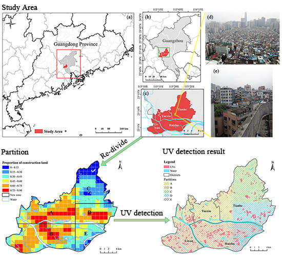
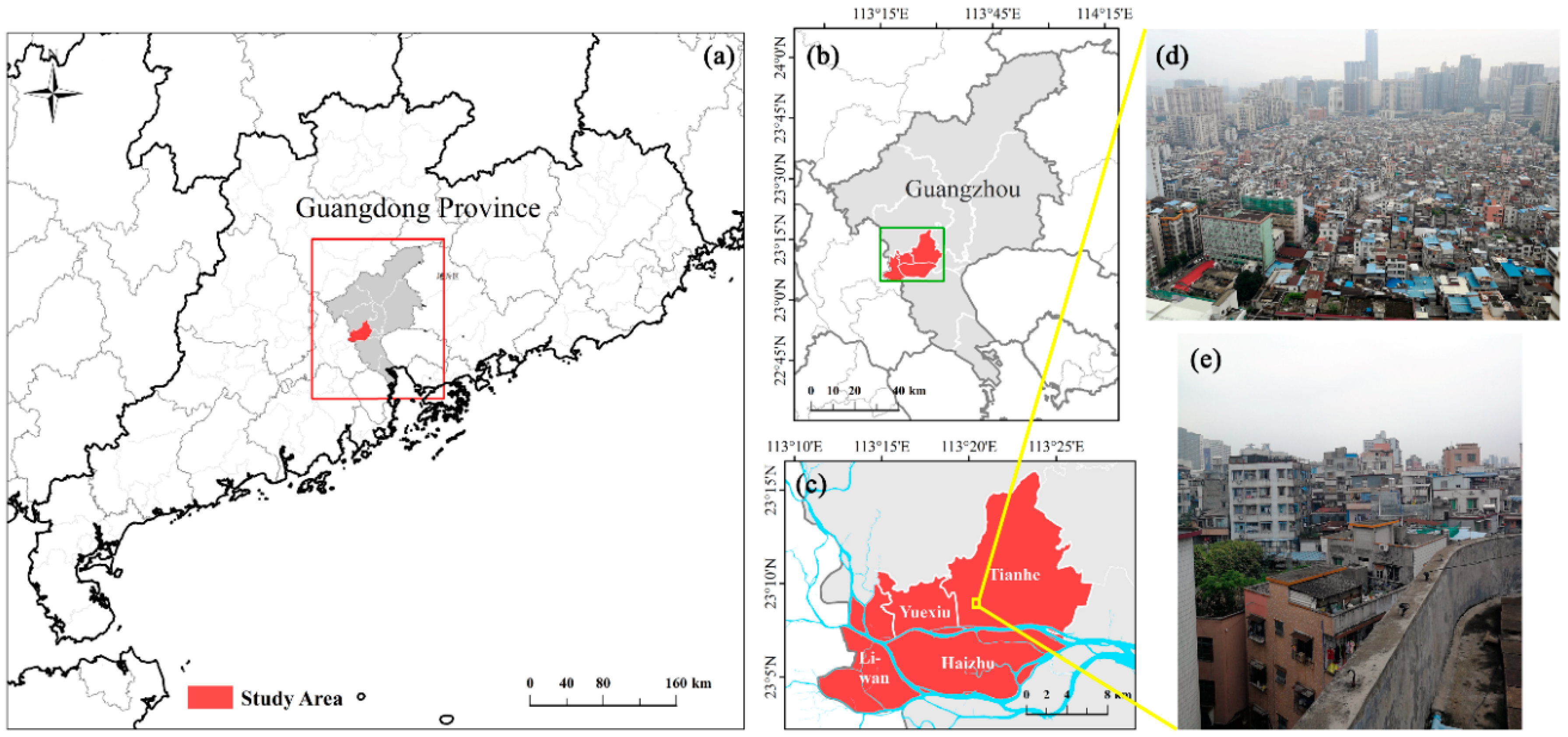
2. Study Area and Data
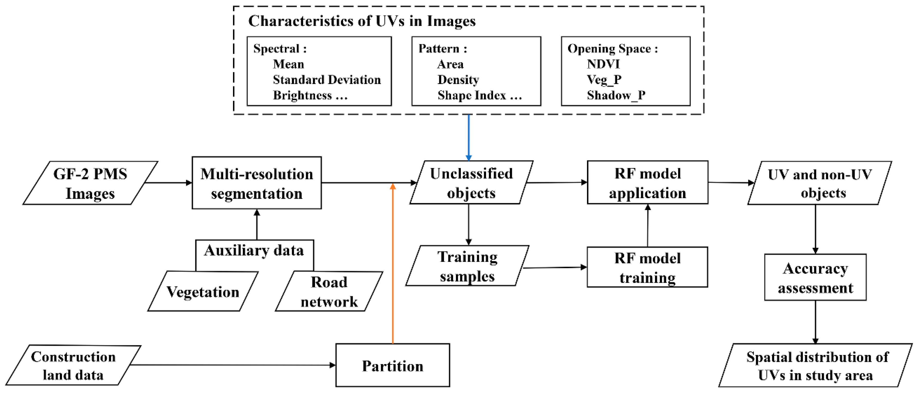
3. Methods
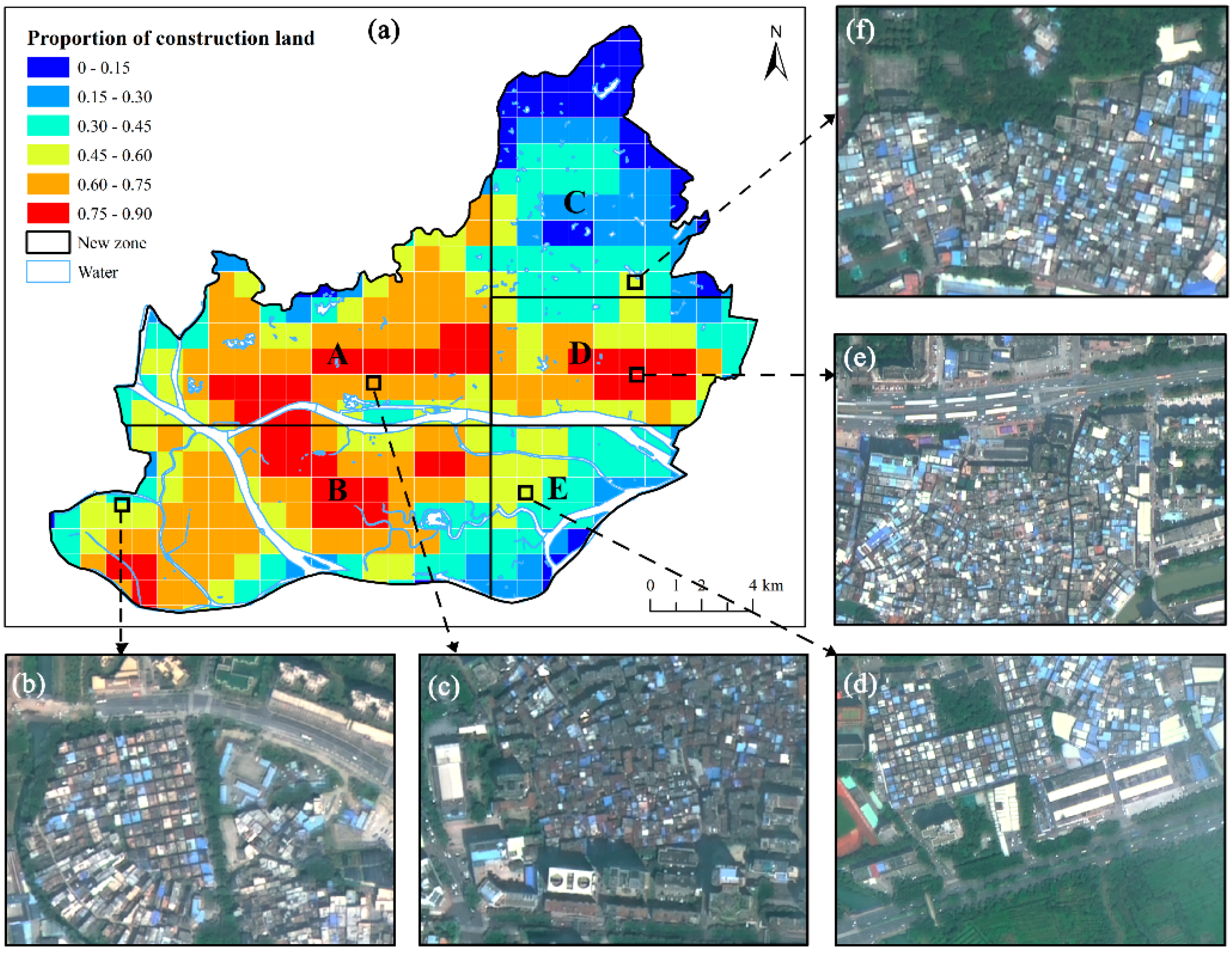
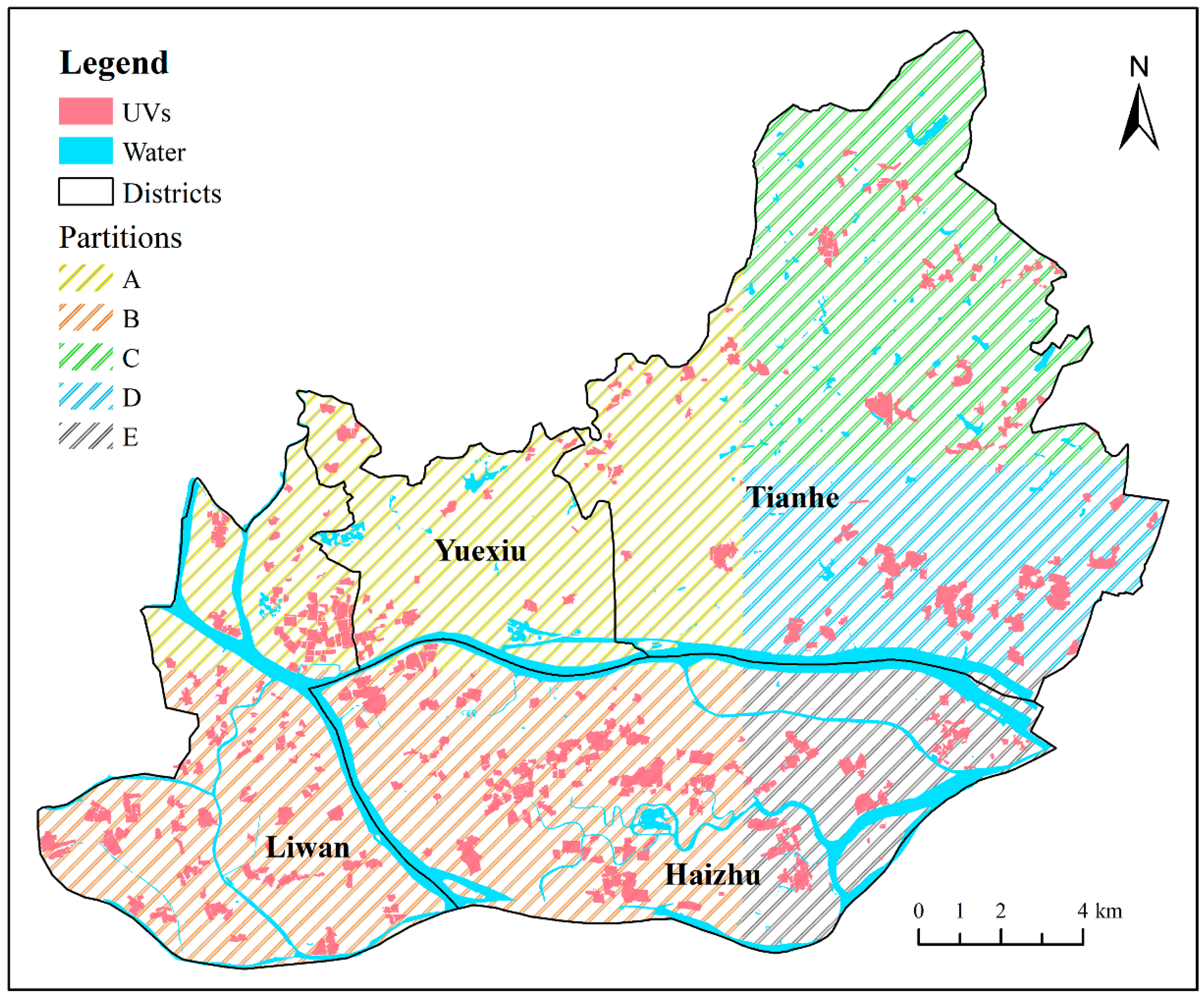
3.1. Partition Strategy
3.2. Multi-Resolution Image Segmentation
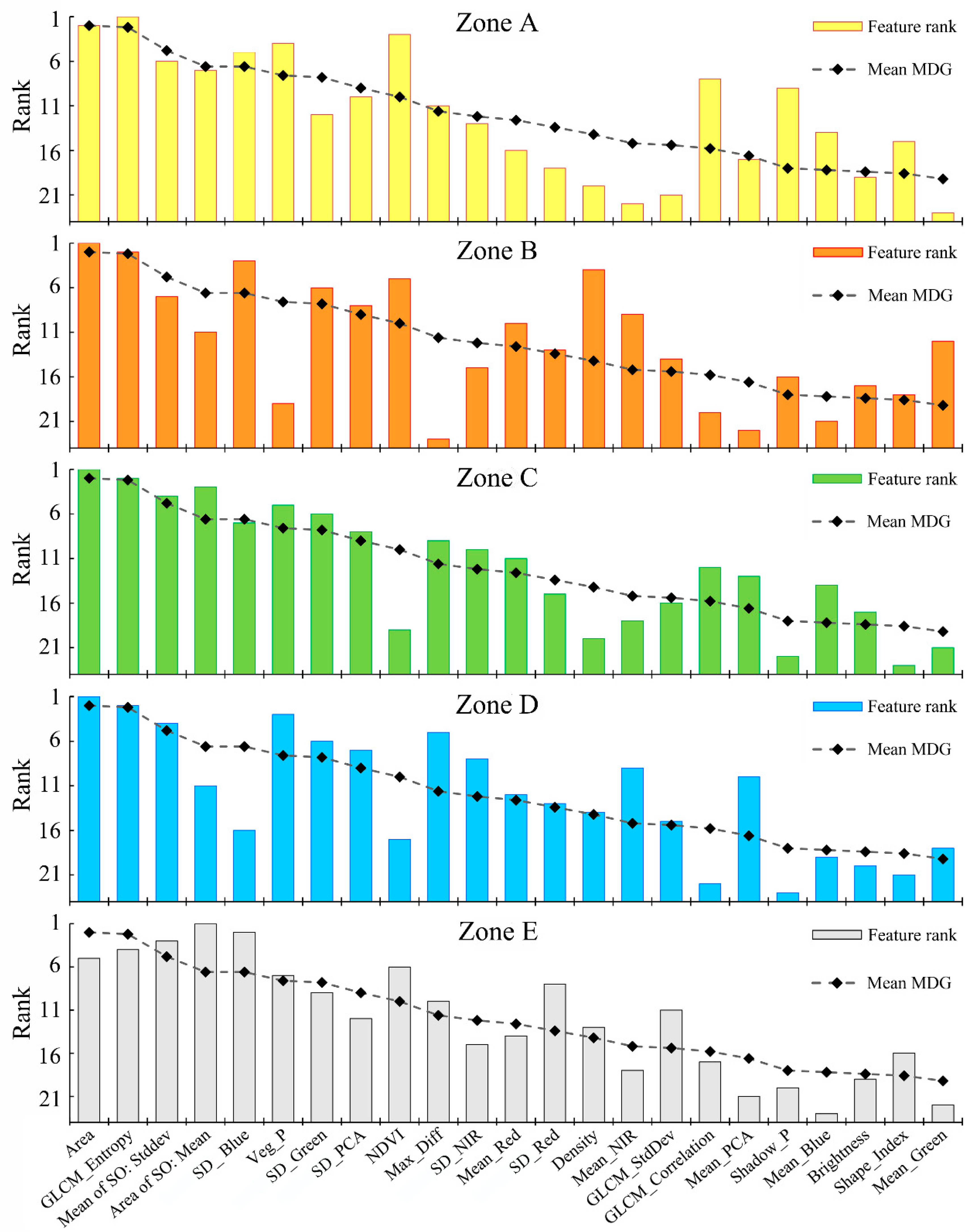
3.3. Feature Selection
3.4. Classification Process
3.4.1. Sample Selection
3.4.2. Model Building
3.4.3. Accuracy Assessment
4. Results
4.1. Evaluation of the UV-Detection Model
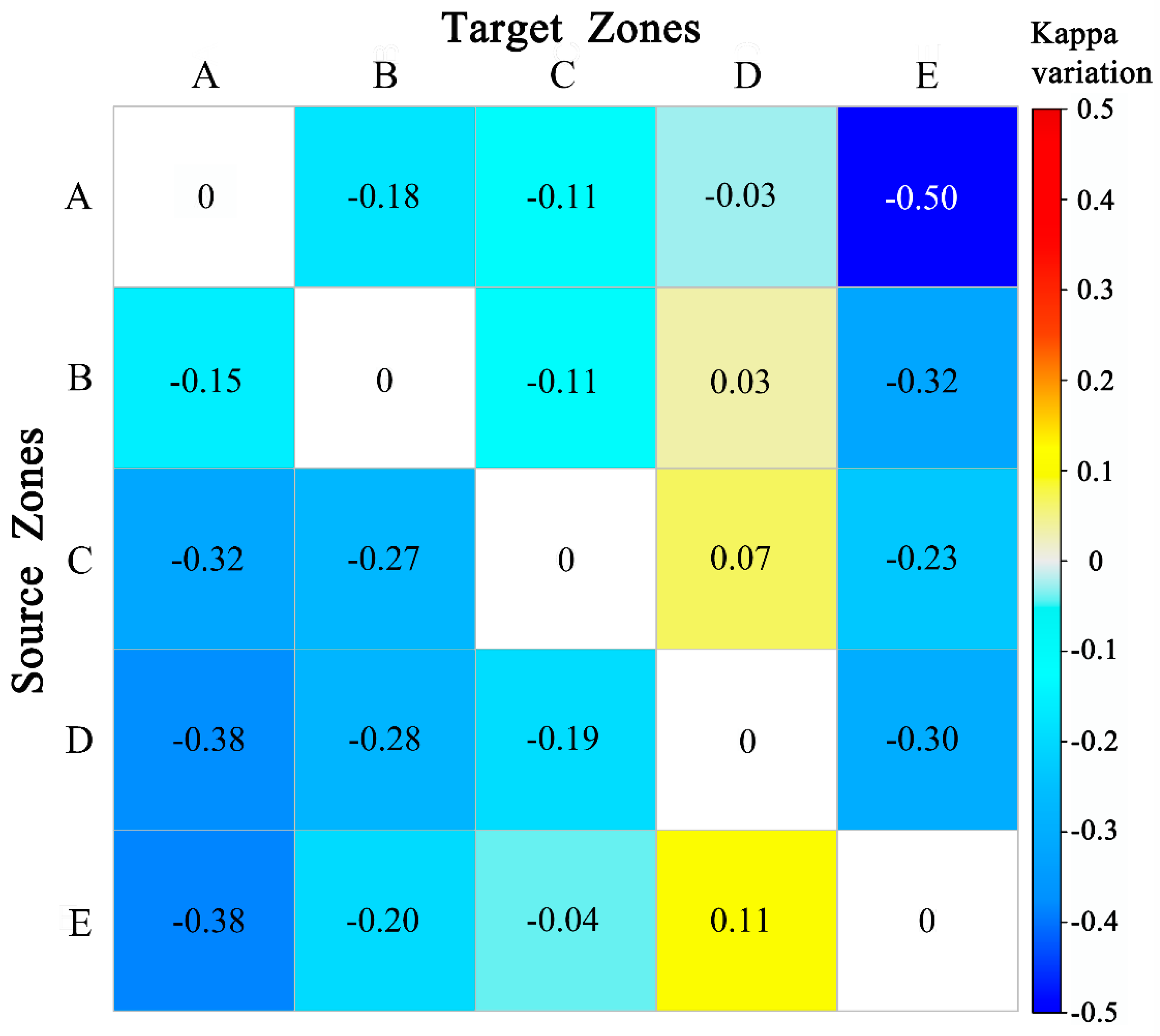
4.2. Assessment of Partition Strategy
4.3. Comparison of Feature Significances
4.4. Adaptability of Samples and Models in an Individual Zone
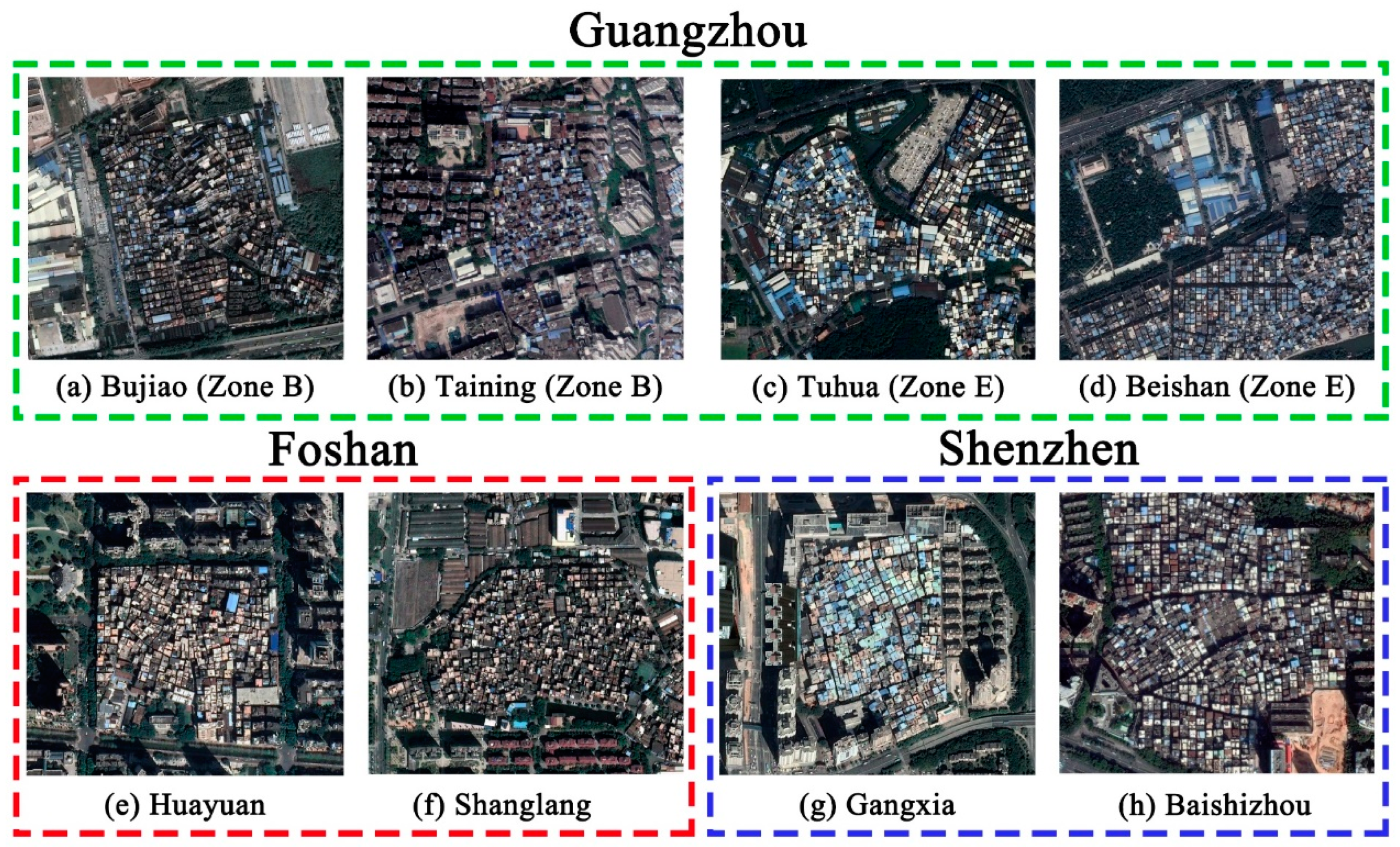
5. Discussion
6. Conclusions
Supplementary Materials
Author Contributions
Funding
Acknowledgments
Conflicts of Interest
References
- Henderson, V. Urbanization in developing countries. World Bank Res. Obs. 2002, 17, 89–112. [Google Scholar] [CrossRef]
- Chen, M.; Liu, W.; Tao, X. Evolution and assessment on China’s urbanization 1960–2010: Under-urbanization or over-urbanization? Habitat Int. 2013, 38, 25–33. [Google Scholar] [CrossRef]
- Lin, Y.; De Meulder, B. A conceptual framework for the strategic urban project approach for the sustainable redevelopment of “villages in the city” in Guangzhou. Habitat Int. 2012, 36, 380–387. [Google Scholar] [CrossRef]
- Dakpallah, T.A.G. Slum Improvement in Ghana: The Study of Aboabo and Asawase in Kumasi. Master’s Thesis, Kwame Nkrumah University of Science and Technology, Kumasi, The Republic of Ghana, July 2011. [Google Scholar]
- Huang, X.; Liu, H.; Zhang, L. Spatiotemporal Detection and Analysis of Urban Villages in Mega City Regions of China Using High-Resolution Remotely Sensed Imagery. IEEE Trans. Geosci. Remote Sens. 2015, 53, 3639–3657. [Google Scholar] [CrossRef]
- Mukeku, J. Urban Slum Morphology and Socio-economic Analogies: A Case Study of Kibera Slum, Nairobi, Kenya. Urbanisation 2018, 3, 17–32. [Google Scholar] [CrossRef]
- Liu, Y.; He, S.; Wu, F.; Webster, C. Urban villages under China’s rapid urbanization: Unregulated assets and transitional neighbourhoods. Habitat Int. 2010, 34, 135–144. [Google Scholar] [CrossRef]
- Riley, L.W.; Ko, A.I.; Unger, A.; Reis, M.G. Slum health: Diseases of neglected populations. BMC Int. Health Hum. Rights 2007, 7, 2. [Google Scholar] [CrossRef] [Green Version]
- Tan, Y.; He, J.; Han, H.; Zhang, W. Evaluating residents’ satisfaction with market-oriented urban village transformation: A case study of Yangji Village in Guangzhou, China. Cities 2019, 95, 102394. [Google Scholar] [CrossRef]
- Ye, Y. Theoretical Framework and Mechanism Innovation of the Inclusive Urban Village Reconstruction in Chinese Megacities: Study and Reflections on Beijing and Guangzhou. City Plan. Rev. 2015, 39, 9–23. [Google Scholar]
- Mahabir, R.; Croitoru, A.; Crooks, A.T.; Agouris, P.; Stefanidis, A. A critical review of high and very high-resolution remote sensing approaches for detecting and mapping slums: Trends, challenges and emerging opportunities. Urban Sci. 2018, 2, 8. [Google Scholar] [CrossRef] [Green Version]
- Kuffer, M.; Pfeffer, K.; Sliuzas, R. Slums from space-15 years of slum mapping using remote sensing. Remote Sens. 2016, 8, 455. [Google Scholar] [CrossRef] [Green Version]
- Mahabir, R.; Crooks, A.; Croitoru, A.; Agouris, P. The study of slums as social and physical constructs: Challenges and emerging research opportunities. Reg. Stud. Reg. Sci. 2016, 3, 399–419. [Google Scholar] [CrossRef] [Green Version]
- Yan, X.; Wei, L.; Zhou, R. Research on the Coordination between Urban and Rural Area in the Rapid Urbanization with the Redevelopment of Guangzhou Village-Amid-the-City as a Case. City Plan. Rev. 2004, 3, 30–38. [Google Scholar]
- Pan, Z.; Xu, J.; Guo, Y.; Hu, Y.; Wang, G. Deep Learning Segmentation and Classification for Urban Village Using a Worldview Satellite Image Based on U-Net. Remote Sens. 2020, 12, 1574. [Google Scholar] [CrossRef]
- Tong, D.; Feng, C.; Deng, J. Spatial evolution and cause analysis of urban villages: A case study of Shenzhen Special Economic Zone. Geogr. Res. 2011, 30, 437–446. [Google Scholar]
- Thomson, D.R.; Kuffer, M.; Boo, G.; Hati, B.; Grippa, T.; Elsey, H.; Linard, C.; Mahabir, R.; Kyobutungi, C.; Maviti, J. Need for an Integrated Deprived Area “Slum” Mapping System (IDEAMAPS) in Low-and Middle-Income Countries (LMICs). Soc. Sci. 2020, 9, 80. [Google Scholar] [CrossRef]
- Owen, K.K.; Wong, D.W. An approach to differentiate informal settlements using spectral, texture, geomorphology and road accessibility metrics. Appl. Geogr. 2013, 38, 107–118. [Google Scholar] [CrossRef]
- Blaschke, T.; Hay, G.J.; Kelly, M.; Lang, S.; Hofmann, P.; Addink, E.; Queiroz Feitosa, R.; van der Meer, F.; van der Werff, H.; van Coillie, F.; et al. Geographic Object-Based Image Analysis-Towards a new paradigm. ISPRS J. Photogramm. Remote Sens. 2014, 87, 180–191. [Google Scholar] [CrossRef] [Green Version]
- Blaschke, T. Object based image analysis for remote sensing. ISPRS J. Photogramm. Remote Sens. 2010, 65, 2–16. [Google Scholar] [CrossRef] [Green Version]
- D’Oleire-Oltmanns, S.; Coenradie, B.; Kleinschmit, B. An object-based classification approach for mapping migrant housing in the mega-urban area of the Pearl River Delta (China). Remote Sens. 2011, 3, 1710–1723. [Google Scholar] [CrossRef] [Green Version]
- Hofmann, P.; Strobl, J.; Blaschke, T.; Kux, H. Detecting informal settlements from QuickBird data in Rio de Janeiro using an object-based approach. In Lecture Notes in Geoinformation and Cartography; Springer: Berlin, Germany, 2008; pp. 531–553. [Google Scholar] [CrossRef]
- Kohli, D.; Sliuzas, R.; Kerle, N.; Stein, A. An ontology of slums for image-based classification. Comput. Environ. Urban Syst. 2012, 36, 154–163. [Google Scholar] [CrossRef]
- Kohli, D.; Warwadekar, P.; Kerle, N.; Sliuzas, R.; Stein, A. Transferability of object-oriented image analysis methods for slum identification. Remote Sens. 2013, 5, 4209–4228. [Google Scholar] [CrossRef] [Green Version]
- Rhinane, H.; Hilali, A.; Berrada, A.; Hakdaoui, M. Detecting slums from SPOT data in Casablanca Morocco using an object based approach. J. Geogr. Inf. Syst. 2011, 3, 217. [Google Scholar] [CrossRef] [Green Version]
- Veljanovski, T.; Kanjir, U.; Pehani, P.; Oštir, K.; Kovačič, P. Object-based image analysis of VHR satellite imagery for population estimation in informal settlement Kibera-Nairobi, Kenya. In Remote Sens. Appl; Escalante, B., Ed.; InTech: Rijeka, Croatia, 2012; pp. 407–434. [Google Scholar]
- Liu, J.; Li, P.; Wang, X. A new segmentation method for very high resolution imagery using spectral and morphological information. ISPRS J. Photogramm. Remote Sens. 2015, 101, 145–162. [Google Scholar] [CrossRef]
- Stark, T. Using Deep Convolutional Neural Networks for the Identification of Informal Settlements to Improve a Sustainable Development in Urban Environments; Technische Universität München: Munich, Germany, 2018. [Google Scholar]
- Kuffer, M.; Barros, J.; Sliuzas, R.V. The development of a morphological unplanned settlement index using very-high-resolution (VHR) imagery. Comput. Environ. Urban Syst. 2014, 48, 138–152. [Google Scholar] [CrossRef]
- Bosch, A.; Zisserman, A.; Muñoz, X. Scene classification via pLSA. In European Conference on Computer Vision; Springer: Berlin/Heidelberg, Germany, 2006; pp. 517–530. [Google Scholar]
- Li, Y.; Huang, X.; Liu, H. Unsupervised deep feature learning for urban village detection from high-resolution remote sensing images. Photogramm. Eng. Remote Sens. 2017, 83, 567–579. [Google Scholar] [CrossRef]
- Liu, H.; Huang, X.; Wen, D.; Li, J. The use of landscape metrics and transfer learning to explore urban villages in China. Remote Sens. 2017, 9, 365. [Google Scholar] [CrossRef] [Green Version]
- Liu, X.; He, J.; Yao, Y.; Zhang, J.; Liang, H.; Wang, H.; Hong, Y. Classifying urban land use by integrating remote sensing and social media data. Int. J. Geogr. Inf. Sci. 2017, 31, 1675–1696. [Google Scholar] [CrossRef]
- Duque, J.C.; Patino, J.E.; Betancourt, A. Exploring the potential of machine learning for automatic slum identification from VHR imagery. Remote Sens. 2017, 9, 895. [Google Scholar] [CrossRef] [Green Version]
- He, X.; Zhang, X.; Xin, Q. Recognition of building group patterns in topographic maps based on graph partitioning and random forest. ISPRS J. Photogramm. Remote Sens. 2018, 136, 26–40. [Google Scholar] [CrossRef]
- Kuffer, M.; Wang, J.; Nagenborg, M.; Pfeffer, K.; Kohli, D.; Sliuzas, R.; Persello, C. The scope of earth-observation to improve the consistency of the SDG slum indicator. ISPRS Int. J. Geo-Inf. 2018, 7, 428. [Google Scholar] [CrossRef] [Green Version]
- Liang, X.; Yuan, Q.; Tan, X.; Li, Z. Territorialization of urban villages in China: The case of Guangzhou. Habitat Int. 2018, 78, 41–50. [Google Scholar] [CrossRef]
- Hao, P.; Geertman, S.; Hooimeijer, P.; Sliuzas, R. Spatial analyses of the urban village development process in shenzhen, china. Int. J. Urban Reg. Res. 2013, 37, 2177–2197. [Google Scholar] [CrossRef]
- Gong, J.; Jiang, C.; Chen, W.; Chen, X.; Liu, Y. Spatiotemporal dynamics in the cultivated and built-up land of Guangzhou: Insights from zoning. Habitat Int. 2018, 82, 104–112. [Google Scholar] [CrossRef]
- Lin, J.; Wan, H.; Cui, Y. Analyzing the spatial factors related to the distributions of building heights in urban areas: A comparative case study in Guangzhou and Shenzhen. Sustain. Cities Soc. 2020, 52, 101854. [Google Scholar] [CrossRef]
- Zhang, S. The Research on the Cities’ Colors Based on Regional Characteristics—Taking City Center of Wuhan as an Example; Wuhan University: Wuhan, China, 2014. [Google Scholar]
- Graesser, J.; Cheriyadat, A.; Vatsavai, R.R.; Chandola, V.; Long, J.; Bright, E. Image based characterization of formal and informal neighborhoods in an urban landscape. IEEE J. Sel. Top. Appl. Earth Obs. Remote Sens. 2012, 5, 1164–1176. [Google Scholar] [CrossRef]
- Taubenböck, H.; Kraff, N.J. The physical face of slums A structural comparison of slums in Mumbai, India based on remotely sensed data. J. Hous. Built Environ. 2014, 29, 15–38. [Google Scholar] [CrossRef]
- Ren, H.; Wu, W.; Li, T.; Yang, Z. Urban villages as transfer stations for dengue fever epidemic: A case study in the Guangzhou, China. PLoS Negl. Trop. Dis. 2019, 13, e0007350. [Google Scholar] [CrossRef] [Green Version]
- Zhang, J.; Ouyang, T.; Zhu, Z.; Bai, Y. Analysis on the expansion mode of Guangzhou’s urban built-up land based on landscape ecology. Ecol. Environ. 2010, 19, 410–414. [Google Scholar]
- Wu, W.; Ren, H.; Yu, M.; Wang, Z. Distinct Influences of Urban Villages on Urban Heat Islands: A Case Study in the Pearl River Delta, China. Int. J. Environ. Res. Public Health 2018, 15, 1666. [Google Scholar] [CrossRef] [Green Version]
- Song, X.; Jiang, X.; Jiang, D.; Huang, Y.; Wan, H.; Wang, C. Object-oriented Classification of High-resolution Remote Sensing Image. Remote Sens. Technol. Appl. 2015, 30, 99–105. [Google Scholar]
- Tan, K.; Zhang, Y.; Wang, X.; Chen, Y. Object-based change detection using multiple classifiers and multi-scale uncertainty analysis. Remote Sens. 2019, 11, 359. [Google Scholar] [CrossRef] [Green Version]
- Johnson, B.; Xie, Z. Unsupervised image segmentation evaluation and refinement using a multi-scale approach. ISPRS J. Photogramm. Remote Sens. 2011, 66, 473–483. [Google Scholar] [CrossRef]
- Baatz, M.; Schäpe, A. An optimization approach for high quality multi-scale image segmentation. In Proceedings of the Angewandte Geographische Informationsverarbeitung XII Beiträge zum AGIT-Symposium Salzburg, Karlsruhe, Germany, 30 June 2000; pp. 12–23. [Google Scholar]
- Drǎguţ, L.; Tiede, D.; Levick, S.R. ESP: A tool to estimate scale parameter for multiresolution image segmentation of remotely sensed data. Int. J. Geogr. Inf. Sci. 2010, 24, 859–871. [Google Scholar] [CrossRef]
- Barros Filho, M.; Sobreira, F. Assessing Texture Pattern in Slum across Scales an Unsupervised Approach; CASA Working Paper 87; Centre for Advanced Spatial Analysis (UCL): London, UK, 2005. [Google Scholar]
- Li, P. Tremendous Changes: The End of Villages-A Study of Villages in the Center of Guangzhou City. Soc. Sci. China 2002, 1, 168–179. [Google Scholar]
- Trimble Documentation. eCognition® Developer 9.0 Reference Book; Trimble Germany GmbH: Munich, Germany, 2014. [Google Scholar]
- Haralick, R.M.; Shanmugam, K.; Dinstein, I.H. Textural features for image classification. IEEE Trans. Syst. ManCybern. 1973, 610–621. [Google Scholar] [CrossRef] [Green Version]
- Shekhar, S. Detecting Slums From Quick Bird Data in Pune Using an Object Oriented Approach. ISPRS Int. Arch. Photogramm. Remote Sens. Spat. Inf. Sci. 2012, 39, 519–524. [Google Scholar] [CrossRef] [Green Version]
- Breiman, L. Random forests. Mach. Learn. 2001, 45, 5–32. [Google Scholar] [CrossRef] [Green Version]
- Wiener, A.L.A.M. Classification and Regression by randomForest. R News 2. R News 2003, 3, 18–22. [Google Scholar]
- Huang, B.F.F.; Boutros, P.C. The parameter sensitivity of random forests. BMC Bioinform. 2016, 17, 331. [Google Scholar] [CrossRef] [Green Version]
- Calle, M.L.; Urrea, V. Letter to the editor: Stability of random forest importance measures. Brief. Bioinform. 2011, 12, 86–89. [Google Scholar] [CrossRef] [PubMed] [Green Version]
- Wu, W.; Li, A.D.; He, X.H.; Ma, R.; Liu, H.B.; Lv, J.K. A comparison of support vector machines, artificial neural network and classification tree for identifying soil texture classes in southwest China. Comput. Electron. Agric. 2018, 144, 86–93. [Google Scholar] [CrossRef]
- Chen, Y.; Chang, K.T.; Han, F.; Karacsonyi, D.; Qian, Q. Investigating urbanization and its spatial determinants in the central districts of Guangzhou, China. Habitat Int. 2016, 51, 59–69. [Google Scholar] [CrossRef]
- Wu, F. Housing in Chinese Urban Villages: The Dwellers, Conditions and Tenancy Informality. Hous. Stud. 2016, 31, 852–870. [Google Scholar] [CrossRef] [Green Version]
- Hu, Z.; Liu, P. The conceptual model and characterizations of landscape genome maps of traditional settlements in China. Acta Geogr. Sin. 2015, 70, 1592–1605. [Google Scholar]
- Hu, W.; He, J. Study on Settlement Development of Guang-Fu Metropolis Based on Spatial Information Technology. Geo-Inf. Sci. 2002, 3, 35–40. [Google Scholar]
- Liu, P.; Liu, C.; Deng, Y.; Shen, X.; Li, B.; Hu, Z. Landscape division of traditional settlement and effect elements of landscape gene in China. Acta Geogr. Sin. 2010, 65, 1496–1506. [Google Scholar]
- Hu, T.; Yang, J.; Li, X.; Gong, P. Mapping urban land use by using landsat images and open social data. Remote Sens. 2016, 8, 151. [Google Scholar] [CrossRef]


| Group | Morphological Characteristic | Feature | Description (Refer to [54,55]) |
|---|---|---|---|
| Spectrum | UV: Diversity roof colors/materials Formal community: Similar roof color Commercial and industrial area: Bright roof | Mean Blue [24] | Mean of pixel values in blue band |
| Mean Green | Mean of pixel values in green band | ||
| Mean Red | Mean of pixel values in red band | ||
| Mean NIR | Mean of pixel values in near-infrared (NIR) band | ||
| Mean PCA | Standard deviation of pixel values in PCA layer | ||
| SD Blue [34] | Standard deviation of pixel values in blue band | ||
| SD Green | Standard deviation of pixel values in green band | ||
| SD Red | Standard deviation of pixel values in red band | ||
| SD NIR | Standard deviation of pixel values in NIR band | ||
| SD PCA | Standard deviation of pixel values in PCA layer | ||
| Brightness [56], | Average of means of all layers | ||
| Max Diff [24,56] | Maximum difference between all layers | ||
| Mean of SO: Stddev [54] | Standard deviation of sub-objects in PCA layer | ||
| Pattern | UV: Small roof sizes; high density; narrow passage Formal community: Regular pattern; same building orientation Commercial and industrial area: Individual building; special architectural styles | Area [24] | Number of pixels |
| Density [54] | Distribution in space of the pixels of an image object, the more an object is shaped like a filament, the lower its density | ||
| Shape Index [29] | Smoothness of object border, the smoother the border of an object is, the lower its shape index | ||
| GLCM_Correlation [44] | Measure of the linear dependency of gray levels of neighboring pixels | ||
| GLCM_Entropy [34] | Measure of the disorder of an image | ||
| GLCM_StdDev [34] | Measure of the dispersion of values around the mean | ||
| Area of SO: Mean [54] | Average area of sub-objects | ||
| Opening Space | UV: Lack of green space and water; less shadow Formal community: Abundant green space between buildings; visible shadow Commercial and industrial area: Surrounded by green/opening space; apparent shadow | NDVI [18] | Normalized difference vegetation index |
| Veg_P | Proportion of vegetation within the 15 m buffer of the object | ||
| Shadow_P | Proportion of shadow within the object |
| Statistical Object | A | B | C | D | E | Total | |
|---|---|---|---|---|---|---|---|
| Segment | 26,543 | 20,186 | 14,011 | 11,100 | 7381 | 79,221 | |
| Sample | UV | 21 | 24 | 13 | 11 | 12 | 81 |
| non-UV | 44 | 48 | 32 | 34 | 31 | 189 | |
| Performance Evaluation Metric | A | B | C | D | E | |
|---|---|---|---|---|---|---|
| RF | Training accuracy/% | 82.61 | 92.16 | 93.55 | 96.88 | 81.48 |
| Testing accuracy/% | 84.21 | 85.71 | 92.86 | 92.31 | 93.75 | |
| SVM | Training accuracy/% | 97.83 | 98.04 | 96.77 | 100 | 100 |
| Testing accuracy/% | 84.21 | 80.95 | 92.86 | 92.31 | 68.75 | |
| Evaluation Metric | A | B | C | D | E | |
|---|---|---|---|---|---|---|
| Producer accuracy (%) | RF | 85.01 | 72.94 | 82.12 | 82.63 | 88.60 |
| SVM | 86.05 | 75.49 | 82.12 | 64.44 | 64.09 | |
| User accuracy (%) | RF | 93.63 | 95.94 | 100 | 96.50 | 96.28 |
| SVM | 93.05 | 94.82 | 90.07 | 98.43 | 99.03 | |
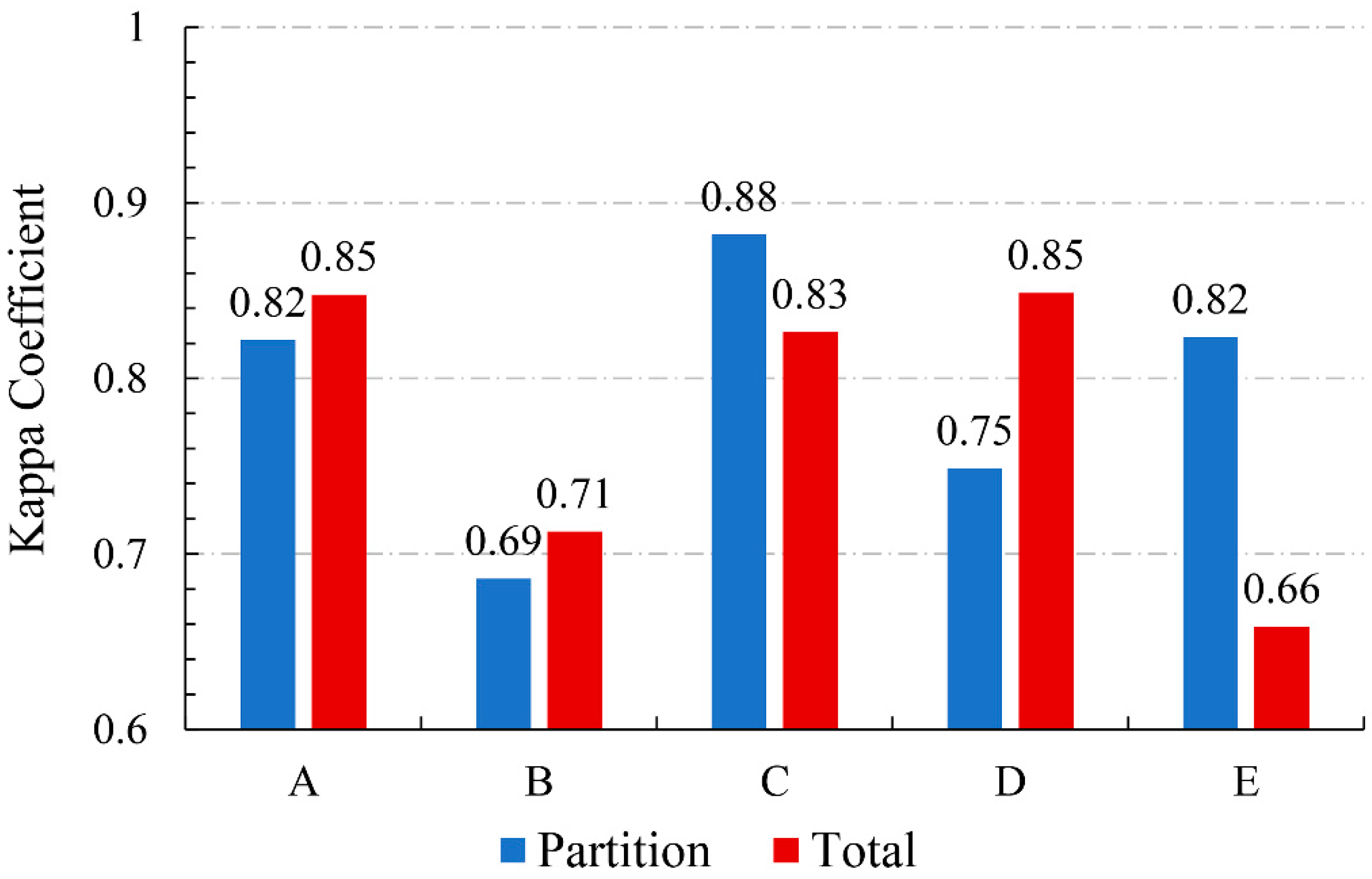
| Kappa coefficient | RF | 0.82 | 0.69 | 0.88 | 0.75 | 0.82 |
| SVM | 0.83 | 0.70 | 0.83 | 0.55 | 0.59 | |
| Mean overall accuracy | RF: 90.23% SVM: 85.22% | |||||
| Mean kappa coefficient | RF: 0.80 SVM: 0.70 | |||||
| Area Statistic | A | B | C | D | E | Total |
|---|---|---|---|---|---|---|
| UVs area (km2) | 4.99 | 10.42 | 2.47 | 3.54 | 2.35 | 23.77 |
| Zone area (km2) | 81.78 | 99.12 | 63.02 | 46.35 | 33.71 | 323.98 |
| Proportion of UVs in the zone (%) | 6.10 | 10.51 | 3.92 | 7.64 | 6.97 | 7.34 |
| Proportion of UVs in total UV (%) | 20.99 | 43.84 | 10.39 | 14.8 | 9.88 | 20.99 |
© 2020 by the authors. Licensee MDPI, Basel, Switzerland. This article is an open access article distributed under the terms and conditions of the Creative Commons Attribution (CC BY) license (http://creativecommons.org/licenses/by/4.0/).
Share and Cite
Zhao, L.; Ren, H.; Cui, C.; Huang, Y. A Partition-Based Detection of Urban Villages Using High-Resolution Remote Sensing Imagery in Guangzhou, China. Remote Sens. 2020, 12, 2334. https://doi.org/10.3390/rs12142334
Zhao L, Ren H, Cui C, Huang Y. A Partition-Based Detection of Urban Villages Using High-Resolution Remote Sensing Imagery in Guangzhou, China. Remote Sensing. 2020; 12(14):2334. https://doi.org/10.3390/rs12142334
Chicago/Turabian StyleZhao, Lu, Hongyan Ren, Cheng Cui, and Yaohuan Huang. 2020. "A Partition-Based Detection of Urban Villages Using High-Resolution Remote Sensing Imagery in Guangzhou, China" Remote Sensing 12, no. 14: 2334. https://doi.org/10.3390/rs12142334
APA StyleZhao, L., Ren, H., Cui, C., & Huang, Y. (2020). A Partition-Based Detection of Urban Villages Using High-Resolution Remote Sensing Imagery in Guangzhou, China. Remote Sensing, 12(14), 2334. https://doi.org/10.3390/rs12142334