Article

Satellite Observations of PM2.5 Changes and Driving Factors Based Forecasting Over China 2000–2025

1
Aerospace Information Research Institute, Chinese Academy of Sciences, Beijing 100101, China
2
Institute of Atmospheric Physics, Chinese Academy of Sciences, Beijing 100029, China
3
College of Resources and Environment, University of Chinese Academy of Sciences, Beijing 100049, China
4
Royal Netherlands Meteorological Institute (KNMI), R&D Satellite Observations, 3731 De Bilt, The Netherlands
5
College of Engineering, University of Wisconsin-Madison, Madison, WI 53706, UAS
*
Author to whom correspondence should be addressed.
Remote Sens. 2020, 12(16), 2518; https://doi.org/10.3390/rs12162518
Submission received: 27 June 2020 / Revised: 1 August 2020 / Accepted: 4 August 2020 / Published: 5 August 2020
(This article belongs to the Section Atmospheric Remote Sensing)

Abstract

:
In China, atmospheric fine particulate matter (PM2.5) pollution is a challenging environmental problem. Systematic PM2.5 measurements have started only in 2013, resulting in a lack of historical data which is a key obstacle for the analysis of long-term PM2.5 trends and forecasting the evolution over this hot region. Satellite data can provide a new approach to derive historical PM2.5 information provided that the column-integrated aerosol properties can adequately be converted to PM2.5. In this study, a recently developed formulation for the calculation of surface PM2.5 concentrations using satellite data is introduced and applied to reconstruct a PM2.5 time series over China from 2000 to 2015. The formulated model is also used to explore the PM2.5 driving factors related to anthropogenic or meteorological parameters in this historical period. The results show that the annually averaged PM2.5 over China’s polluted regions increased rapidly between 2004 and 2007 (with an average rate of 3.07 μg m−3 yr−1) to reach values of up to 61.1 μg m−3 in 2007, and decreased from 2011 to 2015 with an average rate of −2.61 μg m−3 yr−1, to reach a value of 46.9 μg m−3 in 2015. The analysis shows that the increase in PM2.5 before 2008 was mainly associated with increasing anthropogenic factors, further augmented by the effect of meteorological influences. However, the decrease in PM2.5 after 2011 is mainly attributed to the effect of pollution control measures on anthropogenic factors, whereas the effects of meteorological factors have continued to increase since 2000. The results also suggest that further reduction in anthropogenic emissions is needed to accelerate the decrease in PM2.5 concentrations to reach the target of 35 μg m−3 over major polluted areas in China before 2025.

Graphical Abstract

1. Introduction

Following the accelerated development of urbanization and industrialization, air pollution has become a significant threat to public health globally [1]. The State of Global Air 2019 reported the premature death of more than 4.9 million people related to air pollution [2], especially from atmospheric particulate matter entering into the lungs (dry mass of aerosol particles with an in situ diameter smaller than 2.5 µm, or PM2.5), which increases risks of various diseases, including cardiovascular and cerebrovascular diseases, respiratory disease and preterm birth [3,4,5]. Recent analysis of in situ ground-based sampling studies [6,7,8,9,10] revealed the complex mechanism of particle formation during heavy pollution in megacities (e.g., Beijing). Into the 21st century, haze pollution became more and more severe over China [11,12], especially in the east and central regions, highlighting the needs to study PM2.5 pollution conditions over China. However, PM2.5 data from ground stations in China are sparse, and only since January 2013 has the Ministry of Environmental Protection of China provided public information on PM2.5 concentrations in the air operationally. Hence, for the study of temporal trends of PM2.5 and their impact factors, alternative datasets extending to years earlier than 2013 are greatly needed. Moreover, the information on spatial distribution of pollutants over the vast region of China is also missing even after the installation of an extensive network of ground-based monitoring instruments. This is further complicated by issues related to data integration and quality control when trying to merge data from widely different data monitoring methods and instrumentation associated with local and regional governmental agencies.
To address these challenges, satellite remote sensing may offer an alternative solution because of the coverage of large spatial areas over long periods of time and having a great potential for monitoring and studying air pollution [13]. However, satellite retrieval of aerosol properties does not offer the same detail as ground-based in situ measurements, in addition to the limited number of overpasses per day and the limitation to clear skies during daytime. Nevertheless, the aerosol optical depth (AOD) retrieved from satellite observations using sensors such as MODIS [14] is of high quality as deduced from comparison with ground-based reference data, in particular sun photometer data with an accuracy that is an order of magnitude higher [15]. However, the satellite-retrieved information considers aerosol optical properties integrated over the whole atmospheric column, rather than those near the surface. PM2.5 is defined as the mass of particles sampled with an aerodynamic diameter of 2.5 µm in ambient conditions, brought to an environment with a relative humidity of 30–40% [16] where they lose aerosol water. Hence, AOD and PM2.5 describe very different aerosol properties (e.g., in situ optical vs. dry mass; local surface vs. column-integrated concentrations). However, when taking into account the influence of meteorological effects on both AOD and PM2.5, and the aerosol properties, a relationship between these parameters can be established.
Both empirical and physical models have been developed to reproduce estimated PM2.5 concentrations from AOD data. Recent advances provide the ability to address trend analysis of historical PM2.5 data [17,18,19,20,21,22,23,24,25,26,27,28,29,30,31,32]. Ma and co-workers [17,18] employed a statistical model to analyze China’s PM2.5 during 2005–2017 and suggested that the initially increasing trend in PM2.5 has turned into a decrease in recent years. Van Donkelaar et al. (2015) [23] used an atmospheric chemistry model to simulate AOD/PM2.5 relationships and applied the results together with satellite AOD products and landcover type information to produce a global PM2.5 dataset for the years 1998–2012. For the East Asia region, these authors showed an increasing trend in the PM2.5 concentrations of 1.63 μg m−3 yr−1. Yang et al. (2015) [33] quantified the increasing decadal trend of PM2.5 caused by the increase in anthropogenic emissions from 1986 to 2006 using the global three-dimensional Goddard Earth Observing System (GEOS) chemical transport model (GEOS-Chem). Cai et al. (2017) [12] pointed out that weather conditions can be conducive of a higher frequency of the occurrence of haze in Beijing in the future climate scenario of Representative Concentration Pathway (RCP8.5). However, the PM2.5 estimated with these methods have large uncertainties due to uncertainties in the emission scenarios used in the models and uncertainties in instantaneous satellite observations, while a lack of a direct physical flow path prevents researchers from predicting long-term PM2.5 trends.
Physical models have the advantage that they can predict future trends of PM2.5 based on the physical processes describing the effects of different factors on the aerosol concentrations. The particulate matter remote sensing (PMRS) method [22] takes into account the aerosol and meteorological parameters, exploring contributions of different factors to the AOD and PM2.5 relationship. Validation of the modeled PM2.5, using instantaneous AOD data, with collocated in situ observations of PM2.5 [34] shows an average uncertainty of about 31%. By considering the nature of un-correlated uncertainties associated with each instantaneous measurement in the physical method, time averaging (e.g., monthly, yearly) can greatly decrease the uncertainty of the PM2.5 uncertainty in particular analyses. In this study, we improve our previous physical model in the hygroscopic aspect and use it together with satellite aerosol products to estimate PM2.5 concentrations over China from 2000 to 2015. The results are validated against 1442 ground stations (Figure 1) and then used to clarify key factors of the physical method in order to attribute anthropogenic and meteorological contribution factors to PM2.5 variations in China. Based on the attribution analysis, long-term PM2.5 trends are predicted for the period of 2016–2025.

2. Methods

2.1. PM2.5 Remote Sensing (PMRS) Model

PM2.5 mass concentrations near the ground are calculated from aerosol physical and optical parameters using the PMRS model [22]:
P M 2.5 = A O D F M F × V E f ( F M F ) × ρ f , d r y P B L H · f ( R H )
In Equation (1), the aerosol optical depth (AOD), as the first key parameter, represents the total aerosol extinction, i.e., integrated over the whole atmospheric column. VEf is the volume extinction converting function for fine-mode particles, while fine-mode fraction (FMF) describes the fraction of the AOD that is contributed to by fine-mode aerosol particles (AODf = AOD × FMF). FMF is often used as a measure for identifying the particle size characteristics. Planet boundary layer height (PBLH) is the key parameter to characterize the vertical distribution of aerosols in the atmosphere. The effective density of fine-mode dry particles (ρf,dry) is determined by particle composition and f(RH) is the volume hygroscopic growth function, which represents the ratio of the total volume of particulate matter to the dry volume, based on the relative humidity (RH) of the surrounding air. All these parameters and functions have been described in detail in Zhang and Li (2015) [22].
We describe here the improvement of the PM2.5 remote sensing (PMRS) model [22] by including the spatial distribution of the hygroscopic growth factor. Here, the hygroscopic growth factor is reconstructed using the hygroscopic parameter (κ) to improve the performance on the spatial distribution of hygroscopic growth. The κ-Köhler theory proposed by Petters and Kreidenweis (2007) [35] can be represented by the functional form
1 a w = 1 + κ V s V w
where Vs is the volume of the dry particulate matter and Vw is the volume of the water. The activity of water in solution (aw) can be replaced with RH because it is close to RH due to the lower curvature effect [36]. Thus, f in Equation (1) can be derived as follows:
f = V s + V w V s = 1 ( 1 κ ) R H 1 R H
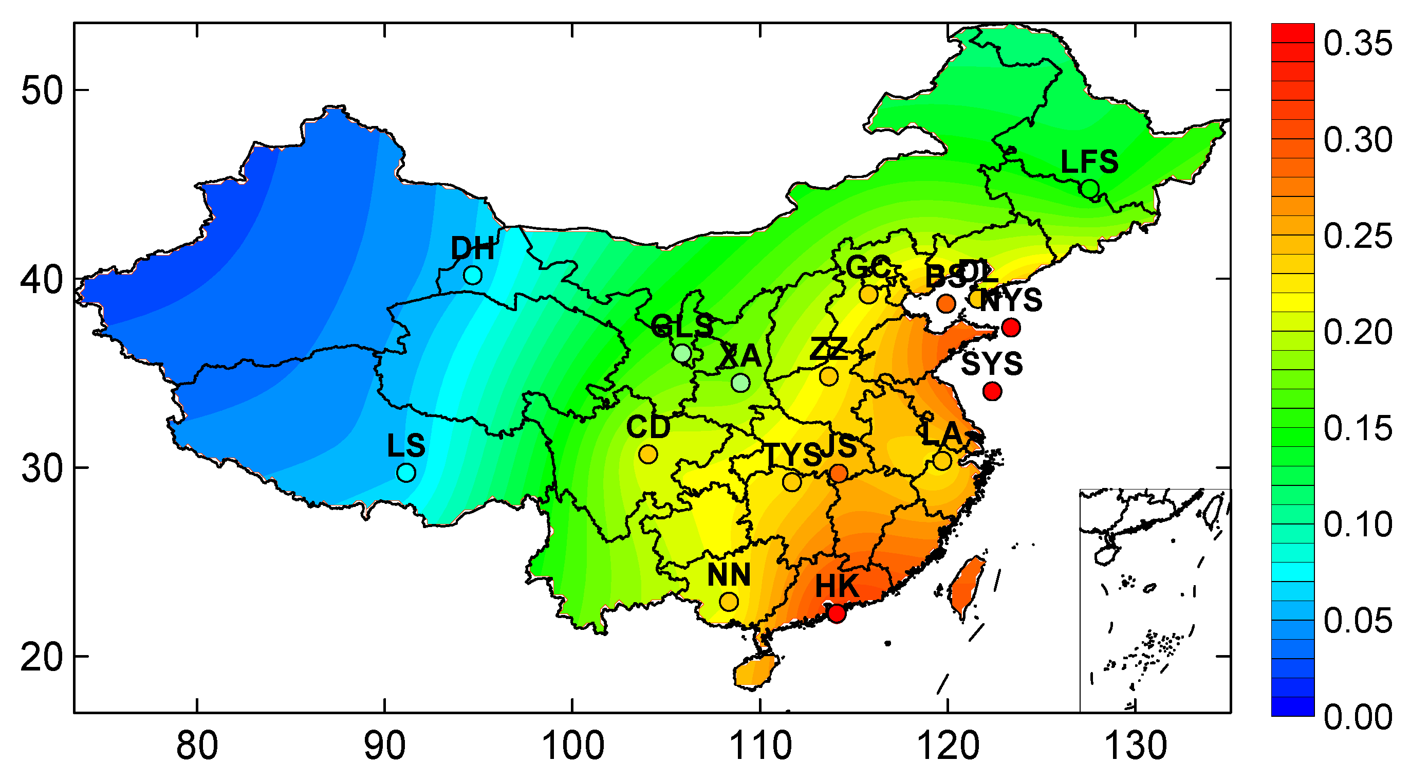
The distribution of κ over China is obtained by kriging space interpolation from measurements at 17 locations (Figure 2). Of these, κ is directly measured at Hongkong [37], and calculated by aerosol chemical components [38] using a simple mixing rule:
κ = i v i κ i
where κi is the hygroscopic parameter of the individual aerosol components which can be measured in the laboratory, and vi is the dry component volume fraction. The κ in the Bohai Sea and the North and South Yellow Seas are estimated from the particle types measured during a ship cruise [39]. The distribution of κ over China thus obtained is shown in Figure 2, together with these experimental data. At the land sites, the extrapolated data compare favorably with local measurements. Its distribution over China varies gradually from high in the east to low in the west, and in coastal areas the value is substantially higher than inland.

2.2. Differential form of PM2.5 and Its Contributing Factors

From the mathematical point of view, the effect of the variation of each of the model parameters influencing the PM2.5 concentration as presented by Equation (1) can be expressed by the variability (Var) of each parameter (also called Jacobian). For obtaining the Var, taking the natural logarithm of Equation (1) results in
ln P M 2.5 = ln A O D d r y + [ ln F M F + ln V E f ( F M F ) ] ln P B L H + ln ρ f , d r y
Note that the dry aerosol optical depth AODdry = AOD/f(RH). Taking the total differential of lnPM2.5 in Equation (5) to yield
Δ P M 2.5 P M 2.5 = 1 A O D d r y Δ A O D d r y + ( 1 F M F + V E f V E f ) Δ F M F 1 P B L H Δ P B L H + 1 ρ f , d r y Δ ρ f , d r y + o
Considering that VEf is defined following Zhang and Li (2015) [22]:
V E f = 0.2887 F M F 2 0.4663 F M F + 0.356
We have
V E f V E f = 0.5774 F M F 0.4663 0.2887 F M F 2 0.4663 F M F + 0.356
Thus, the contribution to PM2.5 can be expressed as the sum of the product terms:
Δ P M 2.5 = P M 2.5 A O D d r y Δ A O D d r y + P M 2.5 F M F Δ F M F + P M 2.5 P B L H Δ P B L H + P M 2.5 ρ f , d r y Δ ρ f , d r y + o = P M 2.5 A O D d r y Δ A O D d r y + P M 2.5 ( 1 F M F + 0.5774 F M F 0.4663 0.2887 F M F 2 0.4663 F M F + 0.356 ) Δ F M F + ( P M 2.5 P B L H ) Δ P B L H + P M 2.5 ρ f , d r y Δ ρ f , d r y + o
The terms on the right-hand side of Equation (9) represent contributions of the model factors to PM2.5, with the same unit as PM2.5 (μg m−3), Δ represents variations or changes, o represents contributions from the higher order terms and all partial derivatives are Var items. Var represents the sensitivity of PM2.5 to changes in model factors. In other words, when Var is large, a small perturbation of a model factor can cause a relatively large contribution to PM2.5. Conversely, if Var is small but the change in the model factor is large, the influence of this factor on PM2.5 will also be small. Although the units of Var are different (μg m−3 times the reciprocal of the model factor’s unit), they have the same meaning explained by the PM2.5 changes when the model factors change by 1 unit. The definitions of all symbols and units used in the paper can be found in Appendix A (Table A1).

2.3. Anthropogenic and Meteorological Factors Contributing to PM2.5

To analyze the driving forces of PM2.5 changes between 2000 and 2015 in China, we classified key parameters of the PMRS physical model into two categories: anthropogenic factors (linked to AODdry and FMF) and meteorological factors (linked to PBLH). The reason for considering AODdry rather than AOD in anthropogenic factors is that AODdry is directly affected by emissions (including primary aerosols and formation of secondary aerosol particles from precursor gases), while AOD is additionally affected by the hygroscopic growth of aerosol particles. Fine-mode particles are mainly generated from industrial production and the daily activities of human beings, whereas coarse particles often originate from natural sources. Therefore, FMF is used as a proxy for anthropogenic aerosols, i.e., aerosols with FMF > 0.85 can be thought of as coming from anthropogenic sources [40]. PBLH is a comprehensive index for atmospheric stability determined by the vertical gradient of the air temperature, the wind speed, etc., and a decrease in PBLH can significantly affect the PM2.5 mass concentration near the surface. Although ρf,dry is an indispensable parameter to estimate the PM2.5 concentration in the PMRS model, we can safely ignore it in the analyses of the contributions of key factors to the variation of PM2.5 because its impact is almost always lower than that of other factors, for the whole effective density range (e.g., 1.0–2.2 g cm−3) as shown in Appendix B. In conclusion, AODdry and FMF are used as proxies related to anthropogenic factors, and PBLH is used as a metric of changes in the meteorological environment.
The interannual changes of anthropogenic and meteorological contributions can be understood as deviations from the average state. Dust events as natural phenomena that occur annually are considered to be contained in the average state. Alternatively, the reduction in dust events with climate change caused by anthropogenic influences [41] is contained in the anthropogenic contribution. The meteorological variables such as wind speed and temperature are often considered in many other studies [17,18,42,43]. However, the impact of wind speed on one satellite image pixel depends on the PM2.5 concentration in the upwind pixel, while that of temperature depends on the concentrations of PM2.5 precursors (e.g., SO2 and NOx). These variables do not have a direct effect on the PM2.5 concentration in a single satellite image pixel and are difficult to account for in models that do not include atmospheric dynamics and chemistry. Fortunately, satellite remote sensing detects the state of the atmosphere at one moment, allowing us to ignore complex processes of atmospheric dynamics and chemistry.

3. Data and Validation

3.1. Satellite and Ancillary Data

In this study, satellite data are used to estimate PM2.5 mass concentrations from the moderate-resolution imaging spectroradiometer (MODIS), onboard both the Aqua and Terra satellites. We use the monthly AOD at 550 nm and FMF data with 1° × 1° horizontal resolution obtained from MODIS Terra and Aqua Collection 5.1 (C5.1) monthly products over China [14]. Terra products have been available from March 2000 and Aqua products from July 2002, and in this study, data from both sensors are used for the whole period until November 2015. Even though these data are not the most up-to-date version, they are intensively validated and much used, and thus suitable for our purpose of analysis of a long period of time. For validation, we compared AOD and FMF data used in this study with collocated Aerosol Robotic Network (AERONET) observations over seven sites (Figure 1) in China.
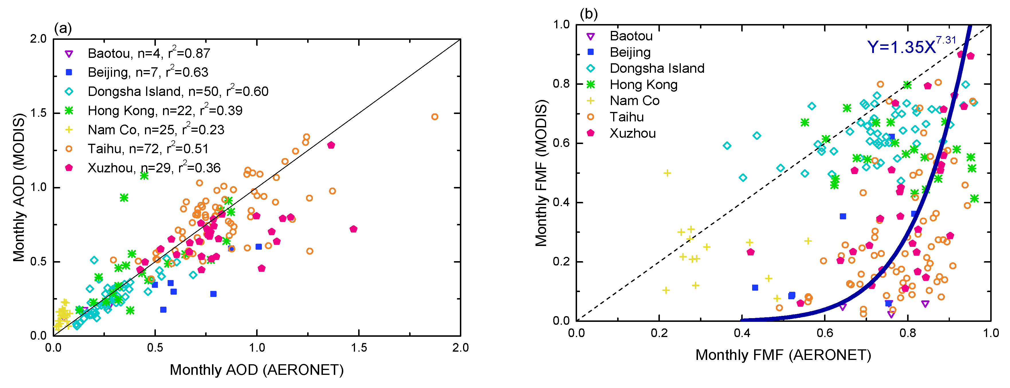
Figure 3 shows the comparison of the monthly MODIS AOD and FMF data with AERONET measurements at 500 nm (Version 2, Level 2.0), with the data pairs for different locations color-coded. Overall, the MODIS AOD is lower than that of AERONET, in particular for Xuzhou and Beijing. This may in part be related to small differences in wavelength (550 nm for MODIS vs. 500 nm for AERONET). For the other sites, the comparison between MODIS and AERONET AOD is quite good, with a correlation coefficient of 0.9. Meanwhile, the mean monthly AOD (0.04) at the Nam Co site is smaller than 0.05, leading to large uncertainties [14]. The comparison of the MODIS and AERONET FMF in Figure 3b shows a large discrepancy, with the MODIS FMF almost always too low at Xuzhou, Taihu and Baotou. In contrast, the discrepancies are relatively small at oceanic (e.g., Dongsha Island and Hong Kong) and western sites (e.g., Nam Co). The underestimation over land sites in eastern China was also reported in several other studies [14]. However, considering that this is the only satellite-derived FMF dataset with global coverage available for a longer period (2000–2015), we used the data at the land sites, except those at Nam_Co (plateau), Dongsha Island and Hong Kong, to fit a non-linear curve as shown in Figure 3b. The result, i.e., the nonlinear regression equation F M F M O D I S = 1.35 F M F A E R O N E T 7.31 , was used to correct the MODIS FMF to the AERONET-derived FMF.
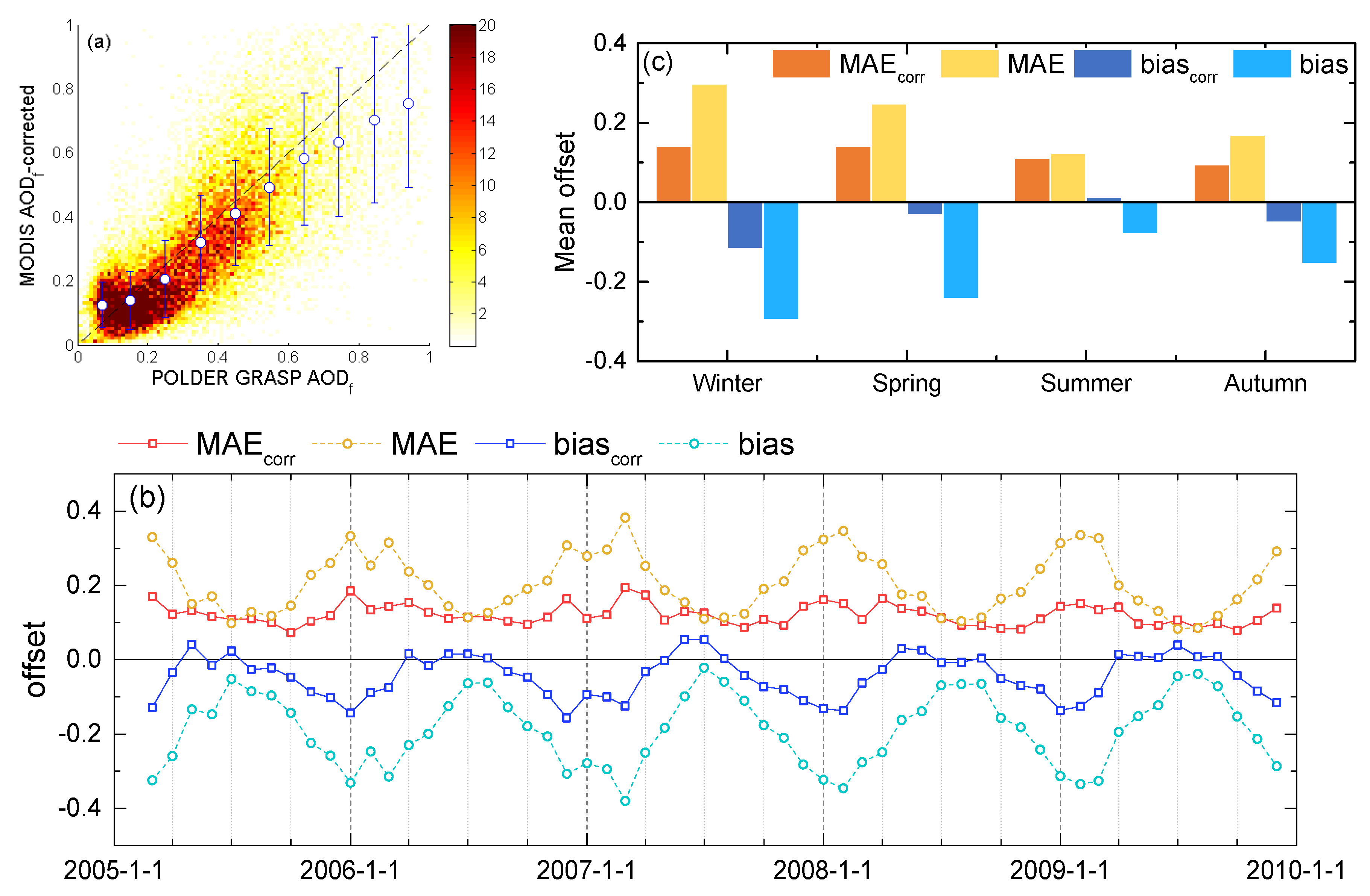
For the evaluation of the results, the corrected MODIS FMF was used to calculate the fine-mode AOD (AODf = FMF × AOD) which subsequently was compared with the recently validated AODf from the newly released POLDER GRASP (High Precision L3) product over China. This POLDER GRASP product compares favorably with SONET AODf products [44]. Concurrent MODIS-Aqua and POLDER data are available for the period from March 2005 to December 2009 (http://www.icare.univ-lille1.fr/parasol/mission (last visited 16 march 2020)). The results are presented in Figure 4, where the MODIS AODf is plotted versus the POLDER AODf (with 1° × 1° horizontal resolution). Figure 4a shows the good correlation between our corrected MODIS AODf and the POLDER GRASP AODf, albeit with a remaining bias of about −0.03. The MODIS AODf-corrected is also averaged over POLDER bins of 0.1 and the average and standard deviation are plotted in Figure 4a. For AODf smaller than about 0.65, the binned data are close to the identity line, but for larger values, they are about 0.1–0.19 below. Figure 4b shows time series of the monthly mean absolute error (MAE) and bias of AODf averaged over China. The MAE and bias from MODIS AODf-corrected data show significant seasonal variation, and the maxima occur in the winter. The AODf -corrected is obviously better than the non-corrected, with the mean MAE and bias of 0.12 and −0.04, whereas these values for the non-corrected AODf are up to 0.21 and −0.19. Although the MODIS AODf -corrected is still slightly low in winter, the MAE is stable and less than 0.19. Figure 4c shows the mean MAE and bias for each season. The MAE for corrected MODIS AODf in the winter and spring are significantly smaller than the MAE for the uncorrected data. In the summer, the MAE changes only little, while the biascorr is close to zero. The results from this intercomparison suggest that the corrected MODIS FMF data, in a meaning of AODf (AOD × FMF), are comparable with POLDER data and thus justify their use in this study which extends beyond the period for which POLDER data are available.
The spatially covered PBLH and surface RH data cannot be obtained from synchronous satellite measurements and thus ancillary data are used. In this study, they are extracted from MERRA2 reanalysis data with 2° × 2.5° horizontal resolution, which were assigned into the MODIS 1° × 1° grid without interpolation (i.e., inverse distance weighted) to prevent rapid changes in coastal areas.

3.2. Satellite-Derived PM2.5 and Validation

The estimated PM2.5 mass concentrations are evaluated by comparison with ground-based PM2.5 data. Ground-based PM2.5 were used from 1442 ground stations in 372 cities (see the map in Figure 1) over China during 2013–2015, published by the China National Environmental Monitoring Centre. To extend the validation to before 2013, PM2.5 data obtained from additional sources were also used in this study, i.e., from the U.S. embassies in Beijing (2008–2015), Shanghai (2011–2015), Guangzhou (2011–2015), Chengdu (2012–2015) and the Hongkong environmental protection agency (2000–2015). It is noted that most of these sites are located in city regions.
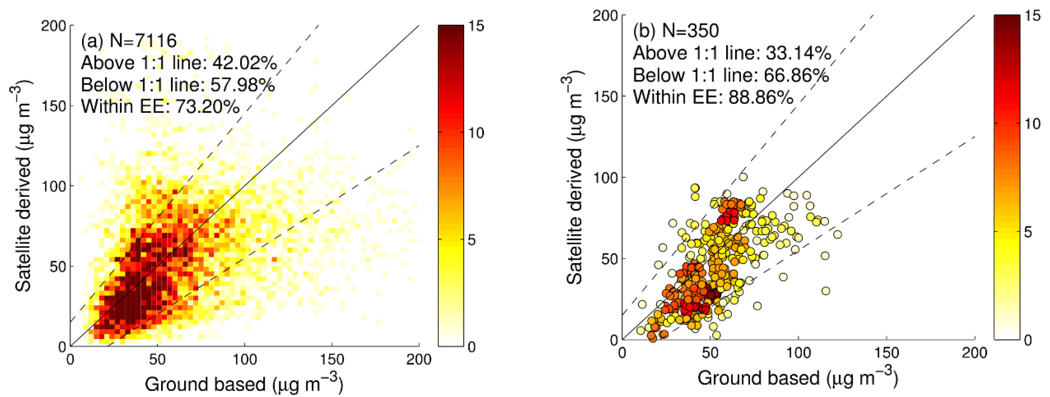
The in situ PM2.5 observations in each city were averaged to increase the spatial representativeness. The satellite-derived PM2.5 data are compared with monthly measurements in a scatter density plot where the data are binned in 3 μg m−3 intervals (Figure 5a). With 42% of the satellite-derived PM2.5 concentrations above the identity line and 58% below, the satellite method slightly under-estimates PM2.5 but overall the comparison is quite good. To further evaluate the PM2.5 data, an expected error (EE) is defined as the sum of the absolute and relative PM2.5 errors [14]. In this PM2.5 dataset, the EE is estimated as 15 μg m−3 ± 30%, and 73% of the data points are within the EE. The comparison between satellite-derived and in situ PM2.5 concentrations averaged over the whole study period from 2013 to 2015 for each of the cities used in this study is presented in Figure 5b. The color in this figure represents the frequency of occurrence of the data pairs. The data in Figure 5b show that the PM2.5 concentrations between 25 and 50 μg m−3 are underestimated, while those between 50 and 75 μg m−3 are overestimated. Overall, 89% of the data pairs are within the EE, with 33% of the three-year averaged PM2.5 concentrations above the identity line and 67% below. These numbers indicate that the satellite-derived PM2.5 are statistically in good agreement with the in situ values.

4. Results

To analyze the inter-annual variation of PM2.5 concentrations and key parameters, we selected five heavily polluted regions in China, including Beijing-Tianjin-Hebei (JJJ), Hebei-Shandong-Henan (HSN), Yangtze River Delta (YRD), Pearl River Delta (PRD) and Si-Chuan Basin (SCB). In addition, we employed the average of these five regions as the mean of China’s typical polluted regions (“polluted mean”, hereafter).

4.1. Spatial Distribution of PM2.5 over China

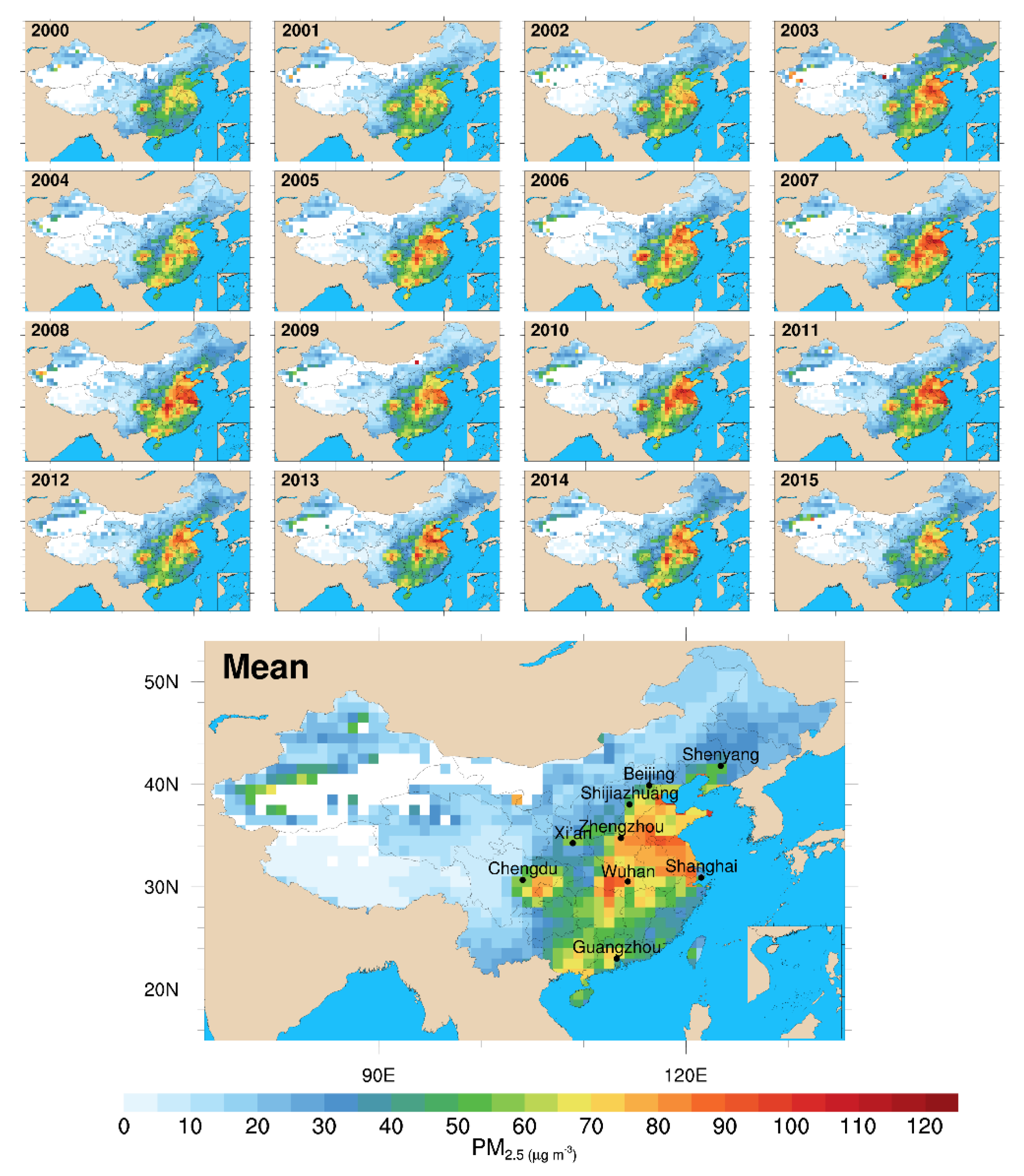
Maps of the annual mean PM2.5 mass concentrations in China for the years 2000–2015 (Figure 6) show that the highest concentrations of PM2.5 occur in East China and especially in central East China, agreeing with spatial distribution characteristics described by Peng et al. (2016) [45] and AOD maps retrieved from MODIS and ATSR sensors [46]. The Si-Chuan Basin and Jianghan plain are divided into two PM2.5 high-concentration areas by the Wuling mountains. In the north China region with high concentrations, a region with a low PM2.5 concentration occurs in the middle of the Shandong province due to the higher altitude and less human activity in the area of the Yimeng mountain and mount Tai. The mean map in Figure 6 shows that the Si-Chuan basin is the west border of China’s polluted areas. Across this border, over western China, the PM2.5 is substantially lower (<20 μg m−3) and has hardly changed during the 16 years of the study period. No data are available over the Tibetan Plateau and desert as well as the arid regions over northwest China (white areas in Figure 6) due to the lack of MODIS FMF retrieval products over these bright surfaces. Slightly elevated PM2.5 concentrations are also observed in the north of the Xinjiang province, which are associated with frequent dust emissions from the nearby deserts.
Since 2004, PM2.5 increased substantially, with higher concentration (i.e., >100 μg m−3) appearing primarily in the eastern and central regions of China, consistent with values reported by van Donkelaar et al. (2015) [23] over eastern Asia. In 2007, the highest annual mean PM2.5 values in 16 years were observed in the most polluted regions (i.e., the Hebei, Shandong and Henan provinces). After a small decline (2008–2009), another peak of high annual mean PM2.5 appeared in 2011. Since then, the polluted areas and levels have decreased gradually.

4.2. Variation of PM2.5 in Polluted Regions for the Years 2000–2015

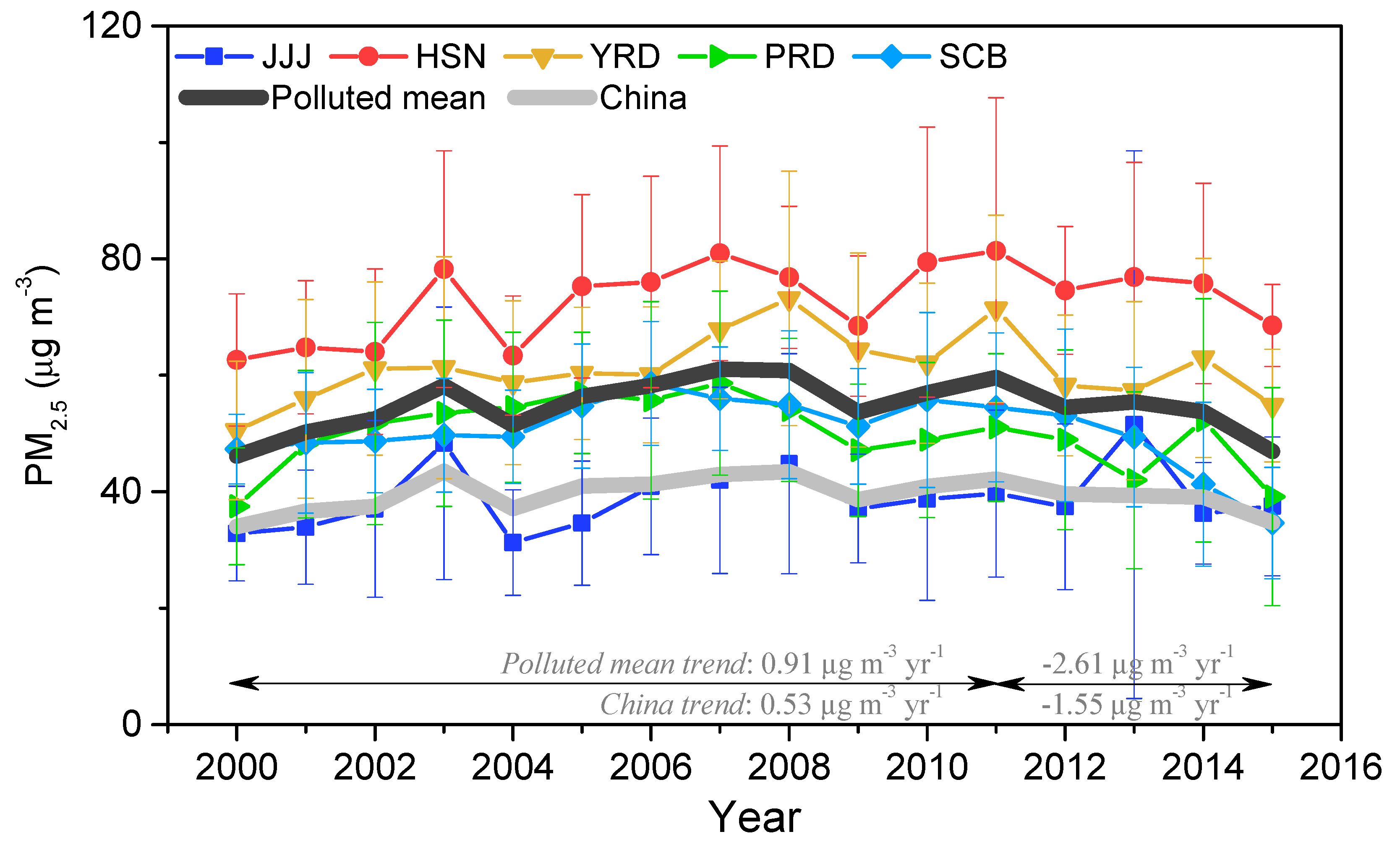
Time series of the annually averaged PM2.5 concentrations for five selected regions are shown in Figure 7, together with the averages over all China and over the polluted region of China. The average PM2.5 in the polluted region was 46.2 μg m−3 in 2000 and increased to 58.2 μg m−3 in 2003. A stronger upward trend (3.07 μg m−3 yr−1) appeared from 2004 to 2007, in good agreement with the increasing trend (3.36 μg m−3 yr−1) given by Ma et al. (2016) [18]. The peak value in the polluted region was 61.1 μg m−3, in 2007. In response to pollution control actions [17], PM2.5 values decreased during the 2007–2009 period. However, accompanying the implementation of the government’s economic boost policies, the pollution increased again after 2009 resulting in a second maximum in the mean PM2.5 values of 59.6 μg m−3 in 2011, with an average increase rate between 2009 and 2011 of 2.98 μg m−3 yr−1. After 2011 (especially after 2013), the PM2.5 mass concentrations clearly decreased with an average of −2.61 μg m−3 yr−1, in response to the implementation of pollution control measures on the national level (i.e., the air pollution prevention action plan listed by Ma et al., 2019 [17]). At the end of our observation period, in 2015, the mean PM2.5 was about 46.9 μg m−3, which is about 1.3 times larger than the WHO interim target 1 (IT-1) PM2.5 level of 35 μg m−3.
During the 16-year study period, the mean PM2.5 in the polluted region increased until 2007, followed by a substantial decrease and another increase between 2009 and 2011. The high-pollution region obviously influenced the average levels over entire China (the light gray curve in Figure 7) which exhibits a similar inter-annual pattern with initial increases and a decrease toward the end of the observation period. Overall, the mean PM2.5 concentrations in entire China were about 30% lower than the mean value for the polluted regions.

4.3. Trend Comparison of PM2.5 over 2000–2015

The PM2.5 trend varies slightly by region as shown in Figure 7. Dramatic increases were observed in JJJ and HSN from 2000 to 2003, but in YRD, SCB and PRD, the increase from 2000 was much smaller and more gradual. The highest PM2.5 concentration occurred in HSN, up to 81.4 μg m−3 in 2011, followed by YRD. The trends and mean PM2.5 in PRD and SCB are close to each other, although the peak years are slightly different. PM2.5 trends in JJJ and HSN are similar because these two regions are adjacent, but the concentration in JJJ is lower.
Trends of the annually averaged satellite-derived and ground-based PM2.5 concentrations are presented in Table 1. The in situ measurements in Hongkong (2000–2015), Beijing (2008–2015), Shanghai (2011–2015), Chengdu (2011–2015) and Guangzhou (2012–2015) span four different periods of time. For the same period, the trends in the five cities are similar as regards both sign and magnitude. The trends in the annually averaged satellite-derived and in situ measured PM2.5 concentrations are similar for each of the five cities or periods, except for Guangzhou. The decreasing trend in satellite-derived PM2.5 in Guangzhou is smaller than that in the ground-based observations. The mean PM2.5 concentrations in Guangzhou from each of the two approaches are close to each other (49.3 vs. 46.2 μg m−3) for the observation period (2012–2015). In Beijing and Chengdu, large differences are observed between the satellite-derived and ground-based PM2.5 concentrations. The large discrepancies are caused by the differences in both the emissions and the terrain between the south and the north of these cities. The different meteorological conditions over a relatively large distance also result in a spatial PM2.5 gradient (low concentrations in the northwest and high in the southeast) across both Beijing [47] and Chengdu [48]. MODIS data with a resolution of 1° × 1° are too coarse to resolve such north–south PM2.5 concentration differences, in contrast to the local in situ measurement which provides a point value which may not be representative for the whole area covered by the satellite pixel.

5. Discussion

5.1. 2000–2015 Variation of Key Parameters and Variabilities

Figure 8 shows time series of three key parameters in the PMRS model and the variations of the corresponding variabilities in polluted areas over China, from 2000–2015. As in Figure 7, the time series are shown for five regions, together with the average for the whole polluted region and another one for all China. Particle effective density ρf,dry is not included because of the small influence as shown in Appendix B.
For the “polluted mean”, obvious peaks of AODdry are observed in 2007 and 2011, and the second one is smaller than the first one. The FMF is overall slowly increasing, with an increment of less than 0.05 from 2000 to 2015, which may be related to the industrial transformation over China. Meanwhile, the decrease in PBLH from 2000 to 2015 is noticeable (−7.5 m yr−1) and the descending PBLH causes a clear increase in the PM2.5 near the ground. By comparing the Var of each key factor, the Var of AODdry is the largest, and greater than 130 μg m−3 in each region. The VarFMF mean value is 74 μg m−3 for the whole polluted region. In comparison, the sensitivity of PM2.5 to PBLH is smaller than that of AODdry or FMF, and the mean absolute values for all regions are not more than 52 μg m−3 km−1. The Var of AODdry increases over the whole study period except for a drop in 2004, while VarFMF increases from 2000 to 2007 and decreases from 2011. VarPBLH is negative and the trend of the absolute value is slightly increasing until 2012. These patterns indicate that the impacts of the above key factors on PM2.5 concentrations get stronger over time. However, a decrease in the Vars of FMF and PBLH is observed over the last three years, together with a weakening of the upward trend in the Var of AODdry, which can be related to pollution control.
The Vars of key parameters between polluted regions show different patterns. In Figure 8b, VarAODdry has a higher value in PRD than that in other regions, indicating that the increase in AODdry can cause a bigger change of PM2.5 in PRD than in other regions. In YRD, VarFMF is high, while in PRD, the VarFMF is relatively low (Figure 8d). In two nearby polluted regions (JJJ and HSN), the VarFMF shows a large difference (49 vs. 91 μg m−3), which may indicate that the level of industrial development varies between these two regions. For VarPBLH, although the mean absolute value in different regions changes from 20 to 62 μg m−3 km−1, the temporal trend of adjacent regions is consistent (Figure 8f). Generally speaking, AODdry has the largest influence on PM2.5, but its interannual variation is not significant. Although FMF has less influence than AOD, it has a stronger influence on the interannual variation of PM2.5. VarPBLH is negative, indicating that its decrease would lead to an increase in PM2.5, and also has a certain interannual variation but not as significant as VarFMF.

5.2. Temporal Changes of Driving Factors’ Contributions to PM2.5

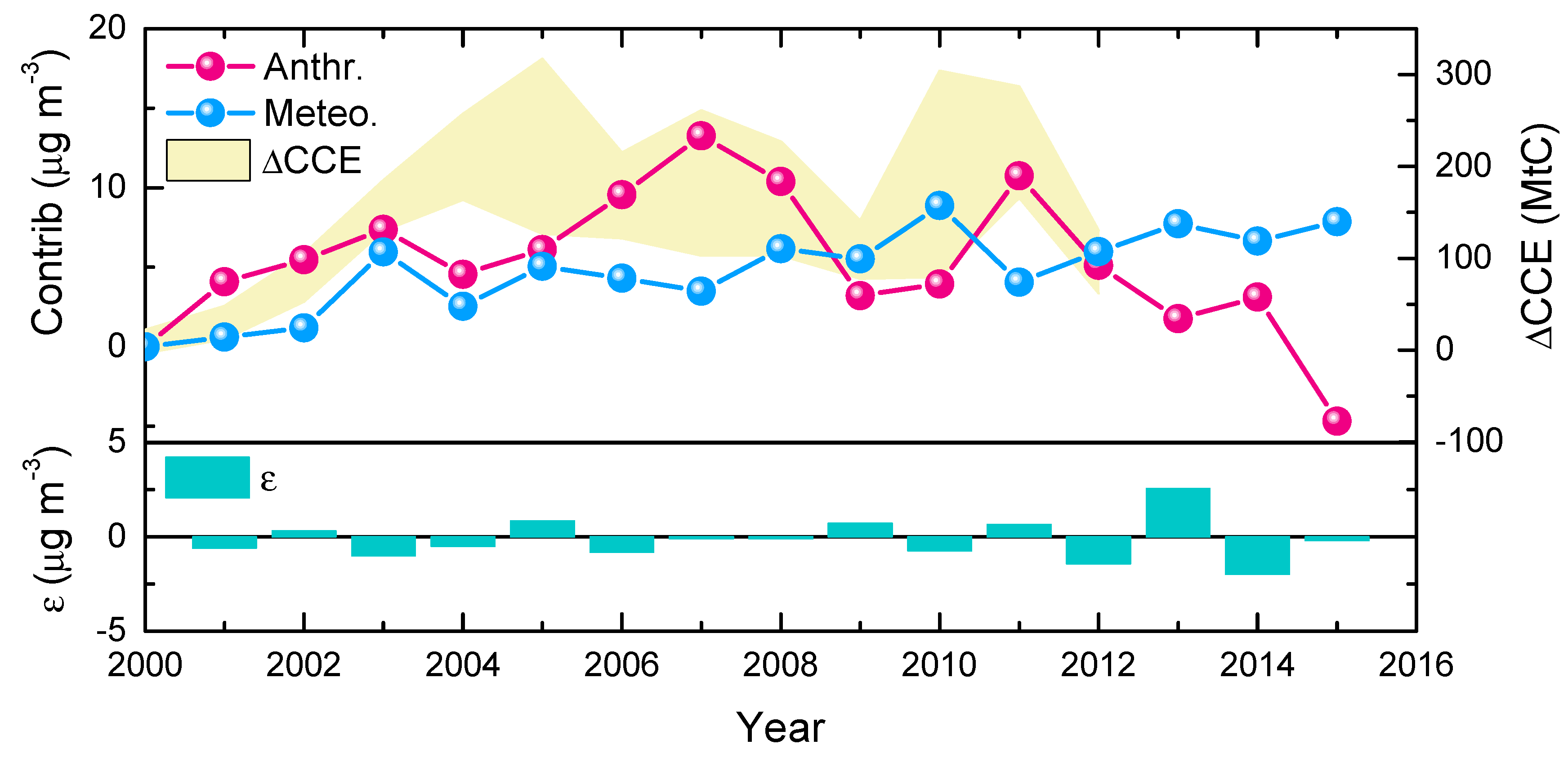
An analysis of 16 years of satellite data was used to investigate intrinsic patterns of anthropogenic and meteorological factors, which help predict future PM2.5 trends. Time series of the accumulated variations of the contributions of driving factors to PM2.5, averaged over the five selected regions, are presented in Figure 9. For a more explicit viewing, the data points are connected by lines, the slopes of which indicate whether the factor has increased (positive slope) or decreased (negative) with respect to the previous year. In addition, the residual item ε (e.g., resulting from neglecting the effective density and higher order terms o in Equation. (9)), can be thought of as a quality index for the successful separation of anthropogenic and meteorological contributions. It is evident that the contribution from anthropogenic factors increased quickly and was dominant around 2007, in good agreement with Yang et al. (2015) [33]. Dang and Liao [49] also found a significant increase in haze days from 2000 to 2007 which is mainly caused by anthropogenic emissions. During 2007–2011, the anthropogenic contribution fluctuated somewhat but remained high (on average 8.3 μg m−3 with respect to 2000). The contribution from meteorological factors slowly increased. Its positive value means that it is accelerating the rise of PM2.5. Kang et al. [50] modeled the variation of AOD over East China between 2001 and 2011 and showed that the increase in AOD caused by natural and anthropogenic factors accounted for 24% and 76%, respectively. These contributions are similar to those in this study for PM2.5 (27% vs. 73% in 2011). After 2011, the anthropogenic contribution has decreased systematically in agreement with the interannual variation of China’s carbon emission (ΔCCE) inventory [51]. However, part of the reduction in the anthropogenic contribution was offset by the meteorological effects on fine particle pollution, which agrees with Cai et al. (2017) [12]. After 2013, the meteorological contribution leveled off. Zhai et al. [52] reported a meteorological contribution of 12% to PM2.5 reduction across China between 2013 and 2018. That means that the increase trend of the meteorological contribution changed after 2015. This could be due to the interaction between anthropogenic and meteorological factors, or it could also be a cyclical weakening of an uptrend similar to that in 2003–2005. Differences between ΔCCE and the anthropogenic curves might be related to uncertainties of CCE inventories (especially before 2005).

5.3. PM2.5 Prediction up to 2025

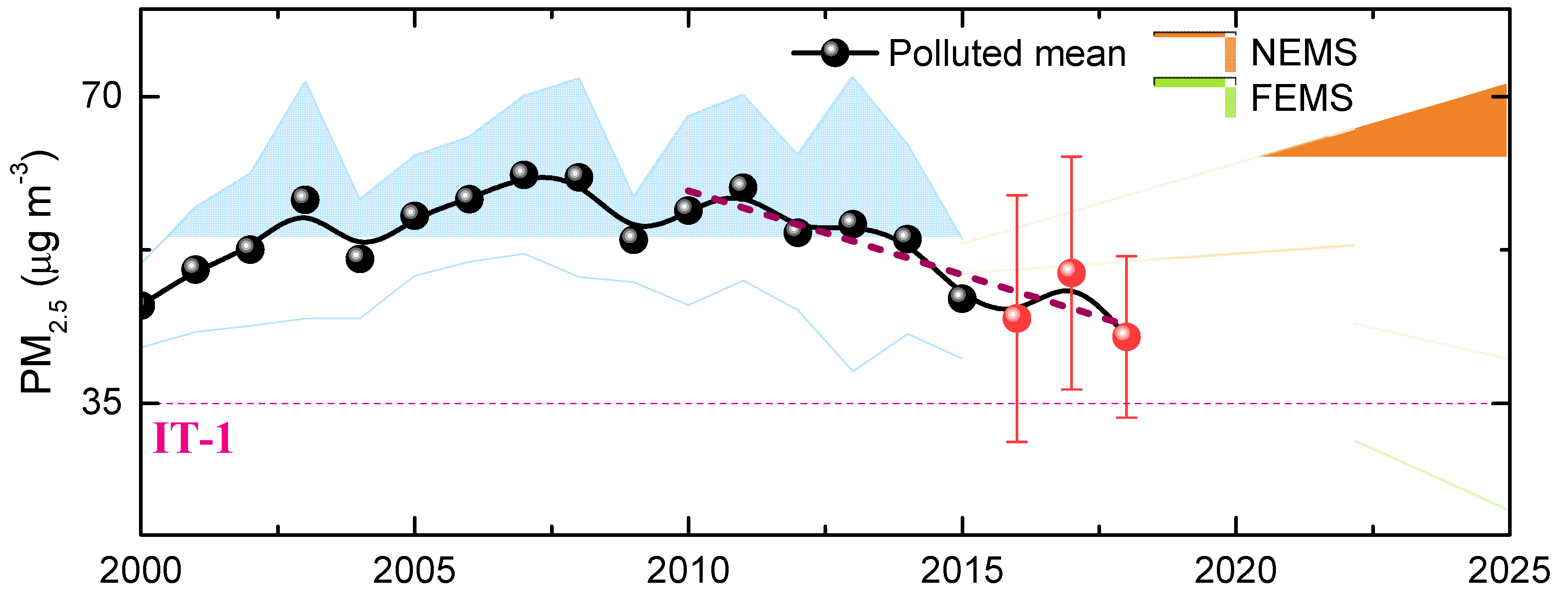
Based on the analysis of the anthropogenic and meteorological factor contributions to PM2.5, the trend of the PM2.5 concentrations over the polluted areas in China can be parameterized and used to predict future trends. Two scenarios were examined: (i) the further emission mitigation scenario (FEMS), which is a continuation of the reduction in the anthropogenic contribution as observed from 2011 to 2015, i.e., at a rate of −3.29 μg m−3 yr−1; and (ii) the normal emission mitigation scenario (NEMS), where the anthropogenic contribution remains at the same level as that in 2015 (i.e., activity level as usual with no increase or decrease). Along with the anthropogenic cases, two meteorological cases were examined: (a) an upper limit of the meteorological factor (i.e., increasing rate of 1.84 μg m−3 yr−1), which is taken from the linear fitting of the meteorological curve using data from 2011 to 2013; and (b) the low-level limit (increasing rate of 0.45 μg m−3 yr−1), which is taken from the same meteorological curve but by fitting all data from 2000 to 2015 (i.e., the same period as that of FEMS). By combining these anthropogenic and meteorological contribution trends, the PM2.5 concentrations in future years can be calculated from 2016.
In Figure 10, navy-blue points represent the satellite-derived annual mean PM2.5 mass concentrations over five polluted areas for 2010 to 2015. The shadowed areas show the extrapolated data to 2025 for two different emission control scenarios (i.e., NEMS and FEMS, with meteorological factors for upper and lower limit). For comparison, the annual mean PM2.5 from ground-based measurements in 2016–2018 are included (red points). These recent PM2.5 data (red points) very well follow the FEMS scenario, and PM2.5 could reach a value of 35 μg m−3, the recommended PM2.5 level for IT−1, from 2021 for the most favorable meteorological conditions. Further, the trend of the annual mean of the ground-based PM2.5 observation in 2016–2018 is close to the FEMS scenario. In 2018, the ground-based PM2.5 is close to the lower limit of the FEMS prediction. These results indicate that China’s emission reduction policy is successful and the reduction in PM2.5 to within the IT-1 target in 2021 is possible following the FEMS scenario. In contrast, in the NEMS scenario the PM2.5 concentrations will continue to increase to about 55–72 μg m−3 in 2025, depending on meteorological factors. In addition, pollution in China decreased significantly from January to March in 2020 due to the COVID−19 outbreak (e.g., Fan et al., 2020) [53], but returned back to normal levels in April [54,55,56,57]. Thus, this can be regarded as a temporary dip, although it could create uncertainty in the 2020 prediction.

5.4. Strengths and Limitations

The physical model for the satellite remote sensing of PM2.5 describes the relationship between AOD and PM2.5 based on physical processes, but there is still one conversion parameter that is not well explained [58]. On this basis, the PMRS model (Equation (1)) establishes a relationship between particle extinction and volume [22], and the PM2.5 satellite remote sensing process is completely disassembled into steps expressed by physical equations. This advance allows the PMRS model to avoid empirical calibration with many historical data, and to have the capabilities of both historical and instantaneous PM2.5 estimates. In Section 2.1, we introduced a new method to improve the hygroscopic growth factor in the PMRS model in order to improve its applicability nationwide. Similarly, further improvement could be possible by the introduction or refinement of other processes. The PMRS model is simple, flexible, fast and friendly to use by people who do not have sufficient knowledge of statistics or chemical transport models. However, the accuracy of the input parameters used in the PMRS model has a significant impact on PM2.5 estimation, so accurate satellite and ancillary data need to be selected for this purpose. In addition, uncertainties of model intrinsic parameters (e.g., κ) also introduce errors of PM2.5 estimates. Therefore, we believe that with the continuous improvement of the accuracy of satellite products and the subprocesses in the PMRS model, the estimates of PM2.5 can be improved further to meet the requirements of environmental applications.
Knowledge on anthropogenic and meteorological contributions to PM2.5 is another important issue for pollution control and climate change. For a long time, the use of a meteorological-chemical model was regarded as the only way to separate the anthropogenic and meteorological contributions by selecting different emission sources. However, the large uncertainties associated with emission inventories could lead to uncertainties in the respective contributions. Observation-based contribution separation depends on the physical model. Each of the subprocesses in the PMRS model has sufficient physical basis, which ensures that the model is continuously differentiable in its interval. It also ensures that the calculation of the anthropogenic and meteorological contributions is possible. Thus, we further extend the PMRS method to directly distinguish between anthropogenic and meteorological contributions based on measurements. The historical trend and driving factors of PM2.5 can be analyzed based on satellite observations, as opposed to using a meteorological-chemical model. Although this method just begins to develop and some part needs to be improved, it is an independent approach different from the meteorological-chemical model approach, which may provide a way of cross-validation of the results.

6. Conclusions

Remote sensing results show that PM2.5 in China exhibits a clear east-high–west-low spatial distribution pattern, with regional high values appearing in regions where human activity is intensive. The mean PM2.5 concentrations in the polluted regions increased from 2000 to up to 61.1 μg m−3 in 2007, and then decreased from 2011 to 46.9 μg m−3 in 2015, as a result of emission reduction policy. The analysis shows that the anthropogenic factors that dominated the PM2.5 increased during 2000–2011. From 2011 to 2015, the continuous reduction of anthropogenic contributions has resulted in a systematic decrease in total PM2.5 in China. Based on trend analyses of anthropogenic and meteorological drivers, the average PM2.5 concentrations in polluted regions of China are expected to decline to 35 μg m−3 in 2021 in a scenario where emissions continue to decrease and meteorological factors are favorable. However, if emissions are held constant at current levels, meteorological drivers will lead to a rebound of PM2.5 concentrations in the future. These results strongly support the need to continue anthropogenic emission control efforts to achieve an accelerated decline of PM2.5 pollution in China.
Uncertainties in the PMRS model include those from the aerosol vertical profile module as described in Li et al. (2016) [34]. In addition, in the presence of a disconnected aerosol layer above the PBL, the aerosols in that layer can contribute up to 40% to the total aerosol loading [59]. This introduces a large uncertainty in the PM2.5 estimation from AOD observations because passive sensors cannot detect disconnected layers and provide only column-integrated quantities (AOD in this case). The satellite-derived PM2.5 may also include uncertainties due to seasonal variation in the corrected FMF as described in Section 3.1. Another weakness of satellite remote sensing is the limitation to clear sky and the availability of sunlight, i.e., no data are available in the presence of clouds or during nighttime. Furthermore, in situations with heavy pollution and thus high AOD, satellite retrieval algorithms have problems to discriminate between aerosols and clouds. Misclassification of high AOD as cloud leads to exclusion from the aerosol dataset, leading to the underestimation of the satellite monthly average value. Moreover, the rapid changes of meteorological parameters between sea and land also affect the estimated accuracy in coastal areas. All of these issues need to be addressed further in future studies.

Author Contributions

Formal analysis, Y.Z. (Ying Zhang); funding acquisition, Z.L.; methodology, Y.Z. (Ying Zhang) and W.C.; project administration, Z.L.; validation, Y.Z. (Ying Zhang); writing—original draft, Y.Z. (Ying Zhang); writing—review and editing, Z.L., Y.Z. (Yuanxun Zhang), G.d.L. and J.J.S. All authors have read and agreed to the published version of the manuscript.

Funding

This research was funded by the National Key B&R Program of China, 2016YFE0201400 and the National Natural Science Fund of China, 41601386, 91544219, 41671367.

Acknowledgments

We thank Marshall Schlick of the University of Wisconsin-Madison for editorial suggestions.

Conflicts of Interest

The authors declare no conflict of interest.

Appendix A

Table A1. Symbols, definition and units used in the paper.
Abbr.Full Name or DefinitionUnit
PM2.5Mass concentration of dry (i.e., at low RH) particulate matter with in situ (i.e., in ambient RH) aerodynamic diameter smaller than 2.5 μmμg m−3
Model
key parameters
AODAerosol optical depth, i.e., column-integrated aerosol extinction-
FMFFine-mode fraction (fraction of fine-mode contribution to total AOD)-
PBLHPlanetary boundary layer heightkm
RHRelative humidity%
ρ2.5,dryEffective density of dry particulates of PM2.5g cm−3
VEfVolume-to-extinction ratio of fine particulatesμm3 μm−2
f(RH)Particle volume drying factor-
VarPartial derivative, Jacobian, or variability of the model factor to PM2.5μg m−3 Factor−1
RVRelative variability, i.e., Var/PM2.5Factor−1
ΔVariation or change of variables -
εResidual of the PM2.5 contribution separation processμg m−3

Appendix B

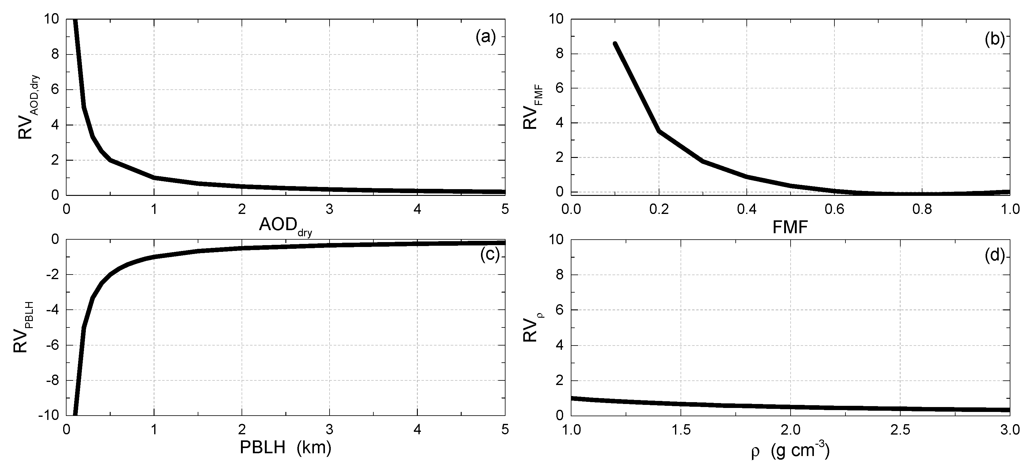
The processes of “mean removal or normalization” can be applied to the variability items to obtain the relative variability (RV = Var / PM2.5), which is convenient for discussing the sensitivity of PM2.5 to key factors. Figure A1 shows the four RVs of the PMRS model as a function of the key factors (AODdry, FMF, PBLH and ρf,dry). The curve in Figure A1a shows that for low values of AODdry, a small increase in AODdry has a large influence on RV AOD dry , i.e., PM2.5 increases vastly with increasing AODdry. For AODdry larger than about 1, a change in AODdry has little influence on PM2.5. Similarly, RVFMF changes substantially when FMF varies from 0.1 to 0.4 but much less for higher values and is close to zero for FMF >0.6. Meanwhile, RVPBLH is negative and decreases remarkably with the decrease in PBLH when PBLH is less than 1 km, and RVPBLH is close to 0.0 when PBLH is larger than 2.0 km. Instead, RVρ is almost always lower than 1.0 in the effective density range (e.g., 1.0–2.2 g cm−3), suggesting that the changes of ρf,dry have much less influence on PM2.5 compared to the other key factors.
Figure A1. The changes of relative variability (RV) as a function of typical ranges of key factors ((a) AODdry, (b) FMF, (c) PBLH, (d) ρf,dry) in the PMRS model.
Remotesensing 12 02518 g0a1

References

  1. Lin, G.; Fu, J.; Jiang, D.; Hu, W.; Dong, D.; Huang, Y.; Zhao, M. Spatio-temporal variation of PM2.5 concentrations and their relationship with geographic and socioeconomic factors in China. Int. J. Environ. Res. Public Health 2014, 11, 173–186. [Google Scholar] [CrossRef] [Green Version]
  2. IHME and HEI, 2019. State of Global Air/2019: A Special Report on Global Exposure to Air Pollution and Its Disease Burden. Institute for Health Metrics and Evaluation, and Health Effects Institute. Available online: https://www.stateofglobalair.org/sites/default/files/soga_2019_report.pdf (accessed on 5 July 2020).
  3. Brook, R.D.; Rajagopalan, S.; Pope, C.A.; Brook, J.R.; Bhatnagar, A.; Bhatnagar, A.; Diez-Roux, A.V.; Holguin, F.; Hong, Y.; Luepker, R.V.; et al. Particulate matter air pollution and cardiovascular disease an update to the scientific statement from the American Heart Association. Circulation 2010, 121, 2331–2378. [Google Scholar] [CrossRef] [Green Version]
  4. Künzli, N.; Jerrett, M.; Mack, W.J.; Beckerman, B.; LaBree, L.; Gilliland, F.; Thomas, D.; Peters, J.; Hodis, H.N. Ambient air pollution and atherosclerosis in Los Angeles. Environ. Health Perspect. 2005, 113, 201–206. [Google Scholar] [CrossRef] [PubMed]
  5. Pope, C.A.; Burnett, R.T.; Thun, M.J.; Calle, E.E.; Krewski, D.; Ito, K.; Thurston, G.D. Lung cancer, cardiopulmonary mortality, and long-term exposure to fine particulate air pollution. Jama J. Am. Med. Assoc. 2002, 287, 1132–1141. [Google Scholar] [CrossRef] [PubMed] [Green Version]
  6. Huang, R.J.; Zhang, Y.; Bozzetti, C.; Ho, K.-F.; Cao, J.-J.; Han, Y.; Deallenbach, K.R.; Slowik, J.G.; Platt, S.M.; Canonaco, F.; et al. High secondary aerosol contribution to particulate pollution during haze events in China. Nature 2014, 514, 218–222. [Google Scholar] [CrossRef] [PubMed] [Green Version]
  7. Zhang, R.; Wang, G.; Guo, S.; Zamora, M.L.; Ying, Q.; Lin, Y.; Wang, W.; Hu, M.; Wang, Y. Formation of Urban Fine Particulate Matter. Chem. Rev. 2015, 115, 3803–3855. [Google Scholar] [CrossRef]
  8. Chu, B.; Kerminen, V.-M.; Bianchi, F.; Yan, C.; Petäjä, T.; Kulmala, M. Atmospheric new particle formation in China. Atmos. Chem. Phys. 2019, 19, 115–138. [Google Scholar] [CrossRef] [Green Version]
  9. Chen, L.; Zhu, J.; Liao, H.; Gao, Y.; Qiu, Y.; Zhang, M.; Liu, Z.; Li, N.; Wang, Y. Assessing the formation and evolution mechanisms of severe haze pollution in the Beijing–Tianjin–Hebei region using process analysis. Atmos. Chem. Phys. 2019, 19, 10845–10864. [Google Scholar] [CrossRef] [Green Version]
  10. Wang, Y.; Yu, M.; Wang, Y.; Tang, G.; Song, T.; Zhou, P.; Liu, Z.; Hu, B.; Ji, D.; Wang, L.; et al. Rapid formation of intense haze episodes via aerosol–boundary layer feedback in Beijing. Atmos. Chem. Phys. 2020, 20, 45–53. [Google Scholar] [CrossRef] [Green Version]
  11. Yang, Y.; Liao, H.; Lou, S. Increase in winter haze over eastern China in recent decades: Roles of variations in meteorological parameters and anthropogenic emissions. J. Geophys. Res. Atmos. 2016, 121, 13–50. [Google Scholar] [CrossRef] [Green Version]
  12. Cai, W.; Li, K.; Liao, H.; Wang, H.; Wu, L. Weather conditions conducive to Beijing severe haze more frequent under climate change. Nat. Clim. Chang. 2017, 7, 257–262. [Google Scholar] [CrossRef]
  13. Hoff, R.M.; Christopher, S.A. Remote sensing of particulate pollution from space: Have we reached the promised land. J. Air Waste Manag. 2009, 59, 645–675. [Google Scholar] [CrossRef]
  14. Levy, R.C.; Remer, L.A.; Kleidman, R.G.; Mattoo, S.; Ichoku, C.; Kahn, R.; Eck, T.F. Global evaluation of the Collection 5 MODIS dark-target aerosol products over land. Atmos. Chem. Phys. 2010, 10, 10399–10420. [Google Scholar] [CrossRef] [Green Version]
  15. Eck, T.F.; Holben, B.N.; Ward, D.E.; Mukelabai, M.M.; Dubovik, O.; Smirnov, A.; Schafer, J.S.; Hsu, N.C.; Piketh, S.J.; Queface, A.; et al. Variability of biomass burning aerosol optical characteristics in southern Africa during the SAFARI 2000 dry season campaign and a comparison of single scattering albedo estimates from radiometric measurements. J. Geophys. Res. Atmos. 2003, 108, 8477. [Google Scholar] [CrossRef]
  16. Pui, D.Y.H.; Chen, S.-C.; Zuo, Z. PM2.5 in China: Measurements, sources, visibility and health effects, and mitigation. Particuology 2014, 13, 1–26. [Google Scholar] [CrossRef]
  17. Ma, Z.; Liu, R.; Liu, Y.; Bi, J. Effects of air pollution control policies on PM2.5 pollution improvement in China from 2005 to 2017: A satellite-based perspective. Atmos. Chem. Phys. 2019, 19, 6861–6877. [Google Scholar] [CrossRef] [Green Version]
  18. Ma, Z.; Hu, X.; Sayer, A.M.; Levy, R.; Zhang, Q.; Xue, Y.; Tong, S.; Bi, J.; Huang, L.; Liu, Y. Satellite-Based Spatiotemporal Trends in PM2.5 Concentrations: China, 2004–2013. Environ. Health Perspect. 2016, 124, 184–192. [Google Scholar] [CrossRef] [Green Version]
  19. Xue, T.; Zheng, Y.; Tong, D.; Zheng, B.; Li, X.; Zhu, T.; Zhang, Q. Spatiotemporal continuous estimates of PM2.5 concentrations in China, 2000–2016: A machine learning method with inputs from satellites, chemical transport model, and ground observations. Environ. Int. 2019, 123, 345–357. [Google Scholar] [CrossRef]
  20. Guo, Y.; Tang, Q.; Gong, D.Y.; Zhang, Z. Estimating ground-level PM2.5 concentrations in Beijing using a satellite-based geographically and temporally weighted regression model. Remote Sens. Environ. 2017, 198, 140–149. [Google Scholar] [CrossRef]
  21. Fang, X.; Zou, B.; Liu, X.; Sternberg, T.; Zhai, L. Satellite-based ground PM2.5 estimation using timely structure adaptive modeling. Remote Sens. Environ. 2016, 186, 152–163. [Google Scholar] [CrossRef]
  22. Zhang, Y.; Li, Z. Remote sensing of atmospheric fine particulate matter (PM2.5) mass concentration near the ground from satellite observation. Remote Sens. Environ. 2015, 160, 252–262. [Google Scholar] [CrossRef]
  23. van Donkelaar, A.; Martin, R.V.; Brauer, M.; Boys, B.L. Use of satellite observations for long-term exposure assessment of global concentrations of fine particulate matter. Environ. Health Perspect. 2015, 123, 135–143. [Google Scholar] [CrossRef] [PubMed] [Green Version]
  24. van Donkelaar, A.; Martin, R.V.; Spurr, R.J.D.; Drury, E.; Remer, L.A.; Levy, R.C.; Wang, J. Optimal estimation for global ground-level fine particulate matter concentrations. J. Geophys. Res. Atmos. 2013, 118, 5621–5636. [Google Scholar] [CrossRef] [Green Version]
  25. van Donkelaar, A.; Martin, R.V.; Brauer, M.; Kahn, R.; Levy, R.; Verduzco, C.; Villeneuve, P.J. Global Estimates of Ambient Fine Particulate Matter Concentrations from Satellite-Based Aerosol Optical Depth: Development and Application. Environ. Health Perspect. 2010, 118, 847–855. [Google Scholar] [CrossRef] [PubMed] [Green Version]
  26. Xu, X.; Wang, J.; Henze, D.K.; Qu, W.; Kopacz, M. Constraints on aerosol sources using GEOS-Chem adjoint and MODIS radiances, and evaluation with multi-sensor (OMI, MISR) data. J. Geophys. Res. Atmos. 2013, 118, 6396–6413. [Google Scholar] [CrossRef] [Green Version]
  27. Lee, H.J.; Coull, B.A.; Bell, M.L.; Koutrakis, P. Use of satellite-based aerosol optical depth and spatial clustering to predict ambient PM2.5 concentrations. Environ. Res. 2012, 118, 8–15. [Google Scholar] [CrossRef] [Green Version]
  28. Drury, E.D.; Jacob, D.J.; Spurr, R.J.D.; Wang, J.; Shinozuka, Y.; Anderson, B.E.; Clarke, A.D.; Dibb, J.; McNaughton, C.; Weber, R. Syntehsis of satellite (MODIS), aircraft (ICARTT), and surface (IMPROVE, EPA-AQS, AERONET) aerosol observations over North America to improve MODIS aerosol retrievals and constrain surface aerosol concentration and sources. J. Geophys. Res. Atmos. 2010, 115, D14204. [Google Scholar] [CrossRef] [Green Version]
  29. Wang, J.; Xu, X.; Spurr, R.; Wang, Y.; Drury, E. Improved algorithm for MODIS satellite retrievals of aerosol optical thickness over land in dusty atmosphere: Implications for air quality monitoring in China. Remote Sens. Environ. 2010, 114, 2575–2583. [Google Scholar] [CrossRef] [Green Version]
  30. Liu, Y.; Paciorek, C.J.; Koutrakis, P. Estimating Regional Spatial and Temporal Variability of PM2.5 Concentrations Using Satellite Data, Meteorology, and Land Use Information. Environ. Health Perspect. 2009, 117, 886–892. [Google Scholar] [CrossRef] [Green Version]
  31. Paciorek, C.J.; Liu, Y. Limitations of Remotely Sensed Aerosol as a Spatial Proxy for Fine Particulate Matter. Environ. Health Perspect. 2009, 117, 904–909. [Google Scholar] [CrossRef] [Green Version]
  32. Gupta, P.; Christopher, S.A. Seven year particulate matter air quality assessment from surface and satellite measurements. Atmos. Chem. Phys. 2008, 8, 3311–3324. [Google Scholar] [CrossRef] [Green Version]
  33. Yang, Y.; Liao, H.; Lou, S. Decadal trend and interannual variation of outflow of aerosol from East Asia: Roles of variations in meteorological parameters and emissions. Atmos. Environ. 2015, 100, 141–153. [Google Scholar] [CrossRef]
  34. Li, Z.; Zhang, Y.; Shao, J.; Li, B.; Hong, J.; Liu, D.; Li, D.; Wei, P.; Li, W.; Li, L.; et al. Remote sensing of atmospheric particulate mass of dry PM2.5 near the ground: Method validation using ground-based measurements. Remote Sens. Environ. 2016, 173, 59–68. [Google Scholar] [CrossRef]
  35. Petters, M.D.; Kreidenweis, S.M. A single parameter representation of hygroscopic growth and cloud condensation nucleus activity. Atmos. Chem. Phys. 2007, 7, 1961–1971. [Google Scholar] [CrossRef] [Green Version]
  36. Tang, I.N. Chemical and size effects of hygroscopic aerosol on light scattering coefficents. J. Geophys. Res. 1996, 101, 19245–19250. [Google Scholar] [CrossRef]
  37. Yeung, M.C.; Lee, B.P.; Li, Y.J.; Chan, C.K. Simultaneous HTDMA and HR-ToF-AMS measurements at the HKUST Supersite in Hong Kong in 2011. J. Geophys. Res. Atmos. 2014, 119, 9864–9883. [Google Scholar] [CrossRef]
  38. Zhang, X.Y.; Wang, Y.Q.; Niu, T.; Zhang, X.C.; Gong, S.L.; Zhang, Y.M.; Sun, J.Y. Atmospheric aerosol compositions in China: Spatial/temporal variability, chemical signature, regional haze distribution and comparisons with global aerosols. Atmos. Chem. Phys. 2012, 12, 779–799. [Google Scholar] [CrossRef] [Green Version]
  39. Fu, H.; Zheng, M.; Yan, C.; Li, X.; Gao, H.; Yao, X.; Guo, Z.; Zhang, Y. Sources and characteristics of fine particles over the Yellow Sea and Bohai Sea using online single particle aerosol mass spectrometer. J. Environ. Sci. 2015, 29, 62–70. [Google Scholar] [CrossRef]
  40. Bellouin, N.; Boucher, O.; Haywood, J.; Reddy, M.S. Global estimate of aerosol direct radiative forcing from satellite measurements. Nature 2005, 438, 1138–1141. [Google Scholar] [CrossRef]
  41. Yang, Y.; Russell, L.M.; Lou, S.; Liao, H.; Guo, J.; Liu, Y.; Singh, B.; Ghan, S.J. Dust-wind interactions can intensify aerosol pollution over eastern China. Nat. Commun. 2017, 8, 15333. [Google Scholar] [CrossRef]
  42. He, Q.; Huang, B. Satellite-based mapping of daily high-resolution ground PM2.5 in China via space-time regression modeling. Remote Sens. Environ. 2018, 206, 72–83. [Google Scholar] [CrossRef]
  43. Hu, X.; Belle, J.H.; Meng, X.; Wildani, A.; Waller, L.A.; Strickland, M.J.; Liu, Y. Estimating PM2.5 concentrations in the conterminous united states using the random forest approach. Environ. Sci. Technol. 2017, 51, 6936–6944. [Google Scholar] [CrossRef] [PubMed]
  44. Wei, Y.; Li, Z.; Zhang, Y.; Chen, C.; Dubovik, O.; Zhang, Y.; Xu, H.; Li, K.; Chen, J.; Wang, H.; et al. Validation of POLDER GRASP Aerosol Optical Retrieval Over China Using SONET Observations. J. Quant. Spectrosc. Radiat. Transf. 2020, 246, 106931. [Google Scholar] [CrossRef]
  45. Peng, J.; Chen, S.; Lv, H.; Liu, Y.; Wu, J. Spatiotemporal patterns of remotely sensed PM2.5 concentration in China from 1999 to 2011. Remote Sens. Environ. 2016, 174, 109–121. [Google Scholar] [CrossRef]
  46. de Leeuw, G.; Sogacheva, L.; Rodriguez, E.; Kourtidis, K.; Georgoulias, A.K.; Alexandri, G.; Amiridis, V.; Proestakis, E.; Marinou, E.; Xue, Y.; et al. Two decades of satellite observations of AOD over mainland China using ATSR-2, AATSR and MODIS/Terra: Data set evaluation and large-scale patterns. Atmos. Chem. Phys. 2018, 18, 1573–1592. [Google Scholar] [CrossRef] [Green Version]
  47. Zhao, C.X.; Wang, Y.Q.; Wang, Y.J.; Zhang, H.L.; Zhao, B.Q. Temporal and spatial distribution of PM2.5 and PM10 pollution status and the correlation of particulate matters and meteorological factors during winter and spring in Beijing. Environ. Sci. 2014, 35, 418–427. [Google Scholar]
  48. Zhang, X.; Liu, J.; Qiu, A.; Liang, Y. Spatial and Temporal distribution of PM2.5 concentration in Sichuan Province in 2016. Geomat. Spat. Inf. Tech. 2018, 41, 40–42. [Google Scholar]
  49. Dang, R.; Liao, H. Severe winter haze days in the Beijing–Tianjin–Hebei region from 1985 to 2017 and the roles of anthropogenic emissions and meteorology. Atmos. Chem. Phys. 2019, 19, 10801–10816. [Google Scholar] [CrossRef] [Green Version]
  50. Kang, H.; Zhu, B.; van der, A.R.J.; Zhu, C.; de Leeuw, G.; Hou, X.; Gao, J. Natural and anthropogenic contributions to long-term variations of SO2, NO2, CO, and AOD over East China. Atmos. Res. 2019, 215, 284–293. [Google Scholar] [CrossRef]
  51. Liu, Z.; Guan, D.; Wei, W.; Davis, S.J.; Ciais, P.; Bai, J.; Peng, S.; Zhang, Q.; Hubacek, K.; marland, G.; et al. Reduced carbon emission estimates from fossil fuel combustion and cement production in China. Nature 2015, 524, 335–338. [Google Scholar] [CrossRef] [Green Version]
  52. Zhai, S.; Jacob, D.J.; Wang, X.; Shen, L.; Li, K.; Zhang, Y.; Gui, K.; Zhao, T.; Liao, H. Fine particulate matter (PM2.5) trends in China, 2013–2018: Separating contributions from anthropogenic emissions and meteorology. Atmos. Chem. Phys. 2019, 19, 11031–11041. [Google Scholar] [CrossRef] [Green Version]
  53. Fan, C.; Li, Y.; Guang, J.; Li, Z.; Elnashar, A.; Allam, M.; de Leeuw, G. The impact of the control measures during the COVID-19 outbreak on air pollution in China. Remote Sens. 2020, 12, 1613. [Google Scholar] [CrossRef]
  54. Bauwens, M.; Compernolle, S.; Stavrakou, T.; Müller, J.-F.; van Gent, J.; Eskes, H.; Levelt, P.F.; van der A, R.; Veefkind, J.P.; Vlietinck, J.; et al. Impact of coronavirus outbreak on NO2 pollution assessed using TROPOMI and OMI observations. Geophys. Res. Lett. 2020, 47. [Google Scholar] [CrossRef]
  55. He, G.; Pan, Y.; Tanaka, T. The short-term impacts of COVID-19 lockdown on urban air pollution in China. Nat. Sustain. 2020. [Google Scholar] [CrossRef]
  56. Filonchyk, M.; Hurynovich, V.; Yan, H.; Gusev, A.; Shpilevsaya, N. Impact Assessment of COVID-19 on Variations of SO2, NO2, CO and AOD over East China. Aerosol Air Qual. Res. 2020, 20, 1530–1540. [Google Scholar] [CrossRef]
  57. Wang, Q.; Su, M. A preliminary assessment of the impact of COVID-19 on environment—A case study of China. Sci. Total Environ. 2020, 728, 1–10. [Google Scholar] [CrossRef] [PubMed]
  58. Koelemeijer, R.B.A.; Homan, C.D.; Matthijsen, J. Comparison of spatial and temporal variations of aerosol optical thickness and particulate matter over Europe. Atmos. Environ. 2006, 40, 5304–5315. [Google Scholar] [CrossRef]
  59. He, Q.; Li, C.; Mao, J.; Lau, A.K.; Chu, D.A. Analysis of aerosol vertical distribution and variability in Hong Kong. J. Geophys. Res. Atmos. 2008, 113, D14211. [Google Scholar] [CrossRef]
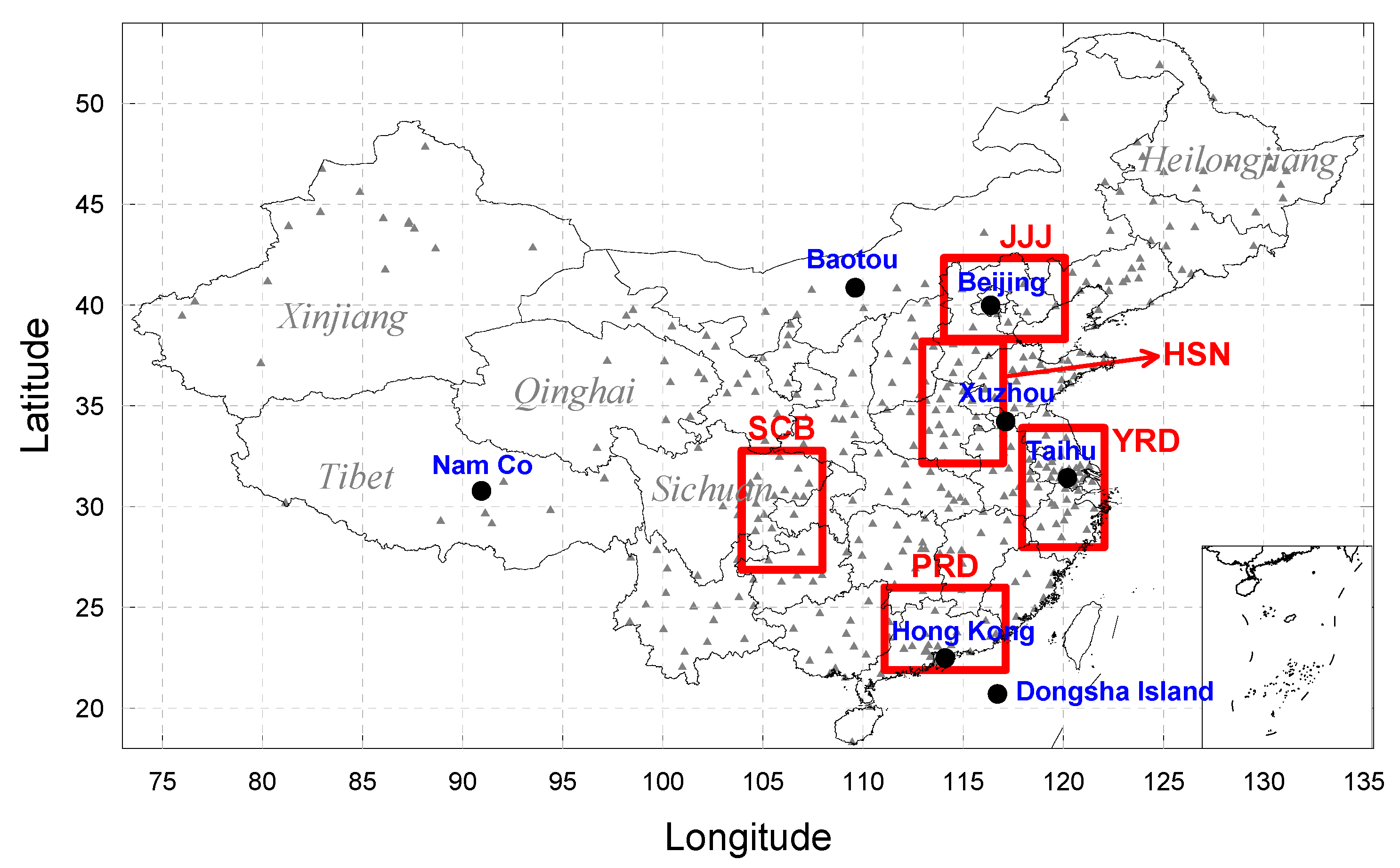
Figure 1. Study area and location of validation sites. The small grey triangles indicate in situ fine particulate matter (PM2.5) stations, and the larger black dots pinpoint the AERONET ground-based sites. The boxes represent the polluted areas selected in China, including Beijing-Tianjing-Hebei (JJJ), Hebei-Shandong-Henan (HSN), Yangtze River Delta (YRD), Pearl River Delta (PRD) and Si-Chuan Basin (SCB).
Remotesensing 12 02518 g001
Figure 2. Distribution of the hygroscopic parameter (κ) over China obtained by kriging space interpolation from measurements at 17 locations, indicated by the circles. The values of κ at these locations were calculated from aerosol chemical components or hygroscopic parameters from Yeung et al. (2014), Zhang et al. (2012) and Fu et al. (2015) [37,38,39].
Remotesensing 12 02518 g002
Figure 3. Comparison of monthly MODIS (a) aerosol optical depth (AOD) and (b) fine-mode fraction (FMF) data with AERONET measurements. The periods for which AERONET data are available vary at different sites and we used all data available from site establishment to 2015. The line in (b) indicates a power law fit of the FMF data (excluding the Nam Co, Hong Kong and Dongsha Island sites) and the relation describing the fit is indicated at the top of the figure, at the right.
Remotesensing 12 02518 g003
Figure 4. (a) Scatter density plot of the corrected MODIS fine-mode AOD (AODf) versus POLDER GRASP AODf (monthly averages). The color represents the number of cases (color bar). The open circles are the bin-averaged MODIS AODf-corrected values and standard deviations, in POLDER GRASP AODf bins with a width of 0.1. “MODIS AODf-corrected” represent the product of MODIS AOD and FMF corrected by the nonlinear fitting function in Figure 3b as described in the text. The dashed line is the 1:1 line. (b) Time series of the monthly averaged mean absolute error (MAE) and bias of AODf; (c) mean MAE and bias for each season. The subscript “corr” represents the MODIS corrected AODf.
Remotesensing 12 02518 g004
Figure 5. (a) Scatter density plots of monthly satellite-derived PM2.5 versus ground-based observations binned in 3 μg m−3 intervals. (b) Comparison of the satellite-derived mean PM2.5 with ground-based measurements, both averaged over the study period (see text), binned in PM2.5 intervals of 8 μg m−3. The color represents the number of cases (color bar). The lines are 1:1 (solid line) and the estimated error (dash lines) with ± (15 μg m−3 +3 0%).
Remotesensing 12 02518 g005
Figure 6. Maps of satellite-derived surface PM2.5 mass concentrations over China for sixteen years (2000–2015) and, at the bottom, the average over all years. The color bar at the bottom indicates the PM2.5 concentrations in µg m−3.
Remotesensing 12 02518 g006
Figure 7. Time series of annual mean PM2.5 mass concentrations over China, for five selected regions, indicated in the legend at the top, for 2000 to 2015. The polluted mean is the average over all five regions. Error bars indicate the standard deviation of the monthly mean. Trends are indicated at the bottom of the figure.
Remotesensing 12 02518 g007
Figure 8. Time series of key parameters ((a) AODdry, (c) FMF and (e) planet boundary layer height (PBLH)) and their variability (Var) (b,d,f) in the particulate matter remote sensing (PMRS) model over China, for five selected regions, and the averages over all five polluted regions and over all China as indicated at the bottom of the figure. The unit of VarAOD,dry and VarFMF is μg m−3, that of VarPBLH is μg m−3 km−1.
Remotesensing 12 02518 g008
Figure 9. Year-by-year contributions to PM2.5 variations (ΔPM2.5) from anthropogenic and meteorological factors averaged over all five polluted regions shown in Figure 1, for the period 2000–2015. ε is the residual. The shadowed area represents the variation range of China’s carbon emission (ΔCCE) interannual changes derived from 24 emission inventories of fossil fuel combustion as reported in Liu et al. (2015) [51].
Remotesensing 12 02518 g009
Figure 10. Satellite-derived annual mean PM2.5 mass concentrations averaged over the five polluted areas for 2010 to 2015 (navy-blue points). These data were extrapolated to 2025 for two different emission control scenarios (NEMS and FEMS, with different meteorological factors), as described in the text. Red points are the annual mean PM2.5 from ground-based measurements in 2016–2018 for comparison with the scenarios. The shaded area is slightly higher than the satellite-derived annual mean PM2.5 for 2015 due to the superposition of anthropogenic and meteorological trend predictions for different periods during 2000 to 2015.
Remotesensing 12 02518 g010
Table 1. Trend (TD) and mean value (M) of satellite-derived yearly PM2.5 and in situ measurements in Hongkong, Beijing, Shanghai, Chengdu and Guangzhou, for different periods. In situ PM2.5 in Hongkong is averaged over 12 sites; that in the four other cities were measured at U.S. embassies. MGB and MSD are “ground-based” and “satellite-derived” in units of μg m−3.
SitePeriodTDGBMGBTDSDMSD
Hongkong2000–20043.1335.33.4635.0
2005–2011−1.7735.0−1.0738.0
2012–2015−0.9228.0−1.3032.5
Beijing2008–2015−3.3988.7−2.4056.0
Shanghai2012–2015−1.5556.1−2.2555.3
Chengdu2012–2015−6.0273.9−4.0850.8
Guangzhou2012–2015−5.9649.3−1.9746.2