Article

A New Weighting Method by Considering the Physical Characteristics of Atmospheric Turbulence and Decorrelation Noise in SBAS-InSAR

1
School of Geoscience and Info-Physics, Central South University, Changsha 410083, China
2
Hunan Province Key Laboratory of Coal Resources Clean-utilization and Mine Environment Protection, Hunan Univeristy and Technology, Xiangtan 411202, China
3
Physical Science and Engineering Division, King Abdullah University of Science and Technology, Thuwal 23966-6900, Saudi Arabia
*
Author to whom correspondence should be addressed.
Remote Sens. 2020, 12(16), 2557; https://doi.org/10.3390/rs12162557
Submission received: 23 June 2020 / Revised: 31 July 2020 / Accepted: 3 August 2020 / Published: 9 August 2020

Abstract

:
Time series of ground subsidence can not only be used to describe motion produced by various anthropocentric and natural process but also to better understand the processes and mechanisms of geohazards and to formulate effective protective measures. For high-accuracy measurement of small baseline subset interferometric synthetic aperture radar (SBAS-InSAR), atmospheric turbulence and decorrelation noise are regarded as random variables and cannot be accurately estimated by a deterministic model when large spatio-temporal variability presents itself. Various weighting methods have been proposed and improved continuously to reduce the effects of these two parts and provide uncertainty information of the estimated parameters, simultaneously. Network-based variance-covariance estimation (NVCE) and graph theory (GT) are the two main weighting methods which were developed on the basis of previous algorithms. However, the NVCE weighting method only focuses on the influence of atmospheric turbulence and neglects the decorrelation noise. The GT method weights each interferogram in a time series by using the Laplace transformation. Although simple to implement, it is not reasonable to have an equal weight for each pixel in the same interferogram. To avoid these limitations, this study presents a new weighting method by considering the physical characteristics of atmospheric turbulence and decorrelation noise in SBAS-InSAR images. The effectiveness of the proposed method was tested and validated by using a set of simulated experiments and a case study on a Hawaiian island. According to the GPS-derived displacements, the average RMSE of the results from the new weighting method was 1.66 cm, indicating about an 8% improvement compared with 1.79, 1.80 and 1.80 cm from the unweighted method, the NVCE method and the GT method, respectively.

Graphical Abstract

1. Introduction

The small baseline subset interferometric synthetic aperture radar (SBAS-InSAR) has been proven as a powerful technique for mapping precipitable water vapor (PWV) in time series [1,2,3,4,5], recovering digital elevation maps (DEM) [6] and measuring the ground surface deformation over large areas caused by crustal movement (e.g., earthquakes, volcanoes and landslides) and human activities (e.g., man-made construction and groundwater extraction) [7,8,9,10,11,12]. However, interferograms involved in SBAS-InSAR calculations can be interfered by imaging conditions (e.g., humidity, temperature and pressure), satellite orbit errors, atmospheric propagation delays and decorrelation noise [13,14,15,16,17,18]. Eliminating those interferences is critical to accurately measuring of SBAS-InSAR. According to previous research, atmospheric phase in each interferogram includes the topography-correlated component (i.e., the vertical stratification) and the short-scale component (i.e., the atmospheric turbulence) [14]. In recent years, significant improvements have been made in the correction of the vertical atmospheric delay phase and orbital error in SBAS-InSAR using the corresponding functional model [19,20,21,22,23]. The atmospheric turbulence and decorrelation noise are still, however, considered random variables in interferogram [14]. Thus, these are hard to describe by determined models.
To reduce the effect of atmospheric turbulence, various external meteorological datasets, such as Medium Resolution Imaging Spectrometer (MERIS), Moderate Resolution Imaging Spectroradiometer (MODIS), Global Positioning System (GPS) and the European Centre for Medium-Range Weather Forecast’s (ECMWF) Re-Analysis Iterim (ERA-I), have been used in SBAS-InSAR [24,25,26,27]. Azeriansyah used the spectrometer correction method with MODIS PWV products to correct the atmospheric delay and monitor land subsidence in Semarang city [28]. Moreover, Xu pointed out that a combined used of ScanSAR and MODIS PWV can be effectively expanded using the InSAR application scope [29]. However, MODIS data are not compatible with ENVISAT. Therefore, the MERIS instrument onboard of ENVISAT is widely used to estimate atmospheric phase delay maps [30]. However, it is noteworthy that MODIS and MERIS images are restricted to cloud-free conditions. Moreover, the spatial resolutions of external datasets are much worse than those of interferograms. Fortunately, numerical weather prediction (NWP) models, such as the mesoscale meteorological model MM5 and the high-resolution weather research and forecasting model (WRF), offer the possibility to mitigate atmospheric signals in interferograms [31,32]. Meanwhile, the ray tracing method was developed for NWP models and Mateus assessed the uncertainty of atmospheric delay maps obtained by NWP models [33,34]. Previous studies found that results based on these NWP models are promising for predicting the topography-dependent part of atmosphere. However, further improvements are needed for the initial and boundary condition data to improve the performances of NWP models in correcting the atmospheric turbulence [35]. In addition, the spatial-temporal filtering method was proposed on the basis of the statistical properties of atmospheric turbulence [36,37,38]. Although simple to implement, this method needs to determine the optimal window length and filtering type. Recently, the multichromatic analysis method was used to correct the atmospheric delay in InSAR [39,40]. It takes advantage of a carrier and Doppler frequency to measure the atmospheric phase. However, sufficient bandwidth is the prior condition of this method.
Until 2011, [41] proposed to weight interferograms in SBAS-InSAR to reduce the influence of atmospheric turbulence. This approach obtains the weights of interferograms in time series by calculating the variance-covariance matrix (VCM) of atmospheric turbulence. However, the covariance of the calculated VCM is considered positive. This assumption can be unreasonable, and [42] suggested the network-based variance-covariance estimation (NVCE) method to correct it. Meanwhile, the NVCE method only focuses on the VCM of atmospheric phase in interferograms and neglects the physical characteristics of decorrelation noise in time domain. Recently, the graph theory (GT) was applied to TS-InSAR and it weights interferograms by the Laplace transformation [43]. The method is easy to implement and computationally efficient. However, it is based on the whole interferogram; therefore, the weight of each pixel in the same interferogram is equal. This is not reasonable since the noise level of each pixel in the same interferogram is different. In summary, all of these methods cannot achieve accurate weighting for each pixel in SBAS-InSAR.
To overcome the abovementioned limitations, the impacts of atmospheric turbulence delays and decorrelation noises on the weight of each pixel in SBAS-InSAR were evaluated in this study. The primary contribution of this new weighting method is that the influences of atmospheric turbulence and decorrelation noises are minimized when estimating deformation parameters. It can not only improve the measurement accuracy of SBAS-InSAR but also the assessment of the uncertainty of estimated parameters.
The rest of this paper is structured as follows: in Section 2, the weighting method considering atmospheric turbulence delays and decorrelation noises is proposed, after a brief introduction of SBAS-InSAR. Then, Section 3 presents simulated and real experiments wherein the proposed new weighting method was applied. Finally, some discussions and conclusions are drawn in Section 4 and Section 5, respectively.

2. Methodology

2.1. Review of SBAS-InSAR Technique

Consider that N   SAR images (Figure 1a) are connected to M (where N 2 M N ( N 1 ) 2   ) interferometric pairs (i.e., Figure 1b) and each SAR image contains T   pixels. According to the principle of standard differential InSAR (D-InSAR), the differential phase (i.e., φ d i f f h , i , j in Equation (1)) of the h t h pixel in an interferogram with master acquisition t i   and slave acquisition t j can be written as [14]:
Δ φ d i f f h , i , j = φ d e f o h , i , j + φ t o p o h , i , j + φ o r b h , i , j + φ a t m h , i , j + φ d e c h , i , j                      
where φ d e f o h , i , j   is the surface deformation phase between the i t h and the j t h SAR acquisition; φ t o p o h , i , j   is the topographic phase, which can be compensated by an external digital elevation model (DEM). φ o r b h , i , j   is the orbit error phase and can be separated from φ d i f f h , i , j by using a surface trend model [23]. φ a t m h , i , j   and φ d e c h , i , j   are the atmospheric and decorrelation noise phase, respectively. As stated above, φ a t m h , i , j   includes the vertical and turbulence part (i.e., φ a t m _ v e r t h , i , j and φ a t m _ t u r b h , i , j , respectively) [14]. Therefore, after removing the vertical stratification atmosphere using a functional model, only the atmospheric turbulence and decorrelation errors are the main factors that affect the weighting matrix for each pixel and limit the measurement accuracy of geophysical parameters.
After removing the residual topographic phase, orbit error and vertical stratification atmosphere (i.e., φ t o p o h , i , j   , φ o r b h , i , j   and φ a t m _ v e r t h , i , j , respectively), Equation (1) can be written in the form of matrices:
Y = G X + e        
where Y   is the differential interferometric phase vector of pixel h and the dimension of Y   is M × 1 . X is the N × 1 unknown parameter vector (i.e., the deformation at each epoch); e is the noise which contains the atmospheric turbulence and decorrelation noise. G   is an incidence matrix which has M rows and N columns. If the older SAR image be adopted as the master, matrix G can be filled in each row with 1 for the former epoch, −1 for the latter and 0 for the rest.
G = [ 1 1   0   0   0   0 1   0 1   0   0   0 01 1   0   0   0                           0   0   0   0   1 1 ]        

2.2. The Variance-Covariance Matrix of Atmospheric Phase in SBAS-InSAR

The vertical stratification atmosphere can be fitted and removed by a model related to the topography [14,23]; therefore, only the turbulence part is analyzed in this study. The atmospheric turbulence is mainly caused by the turbulent mixing of heat and humidity within the atmospheric boundary layer. According to Hanssen (2001) [14], the effect of the atmospheric turbulence is generally less than fifteen minutes with the horizontal scale being less than 1 km. Due to the large spatial and temporal variability, the atmospheric turbulence is hard to estimate by using a deterministic model. Fortunately, Hanssen pointed out that the atmospheric turbulence is relative to the distance between an arbitrary pixel to the reference one. Based on this physical characteristic, the atmospheric turbulence can be described by the variogram or structure function (i.e., Equation (4)) based on the intrinsic stationarity hypothesis [44].
V a r a t m ( r ) = ( Z ( h ) Z ( h + r ) ) 2
where V a r a t m ( r )   is the atmospheric turbulence variance with a spatial distance of r , < · > is the statistical expectation operation and Z ( · ) denotes the observed value. Based on Equation (4), we can obtain a series of variances caused by atmospheric turbulence with different spatial distance r . To obtain the continuous result, namely, variances with any distance, the spherical model (i.e., Equation (5)) is commonly used to approximate the variogram of spatial turbulence delays [42].
V a r a t m ( r ) = { d 0 + d ( 3 r 2 a r 3 2 a 3 )           r a d 0 + d                                                       r > a
where a   is the largest spatial correlation distance and the so-called range. d 0 represents the nugget which mainly caused by the spatial variation of atmospheric turbulence in interferogram. d denotes the sill value of the model in Geostatistics and d 0 + d is commonly considered as the variance of interferogram.
To avoid the effects of deformation, the stacking technique is first used to estimate the subsidence, and the corresponding location of deformation in each interferogram is masked [45]. Then, based on the masked interferogram and Equation (4), the unknown parameters in Equation (5) (i.e., d 0 ,   d ,   a ) can be estimated. According to Equation (5), the variance of the   h th pixel with the reference point in l th interferogram can be obtained.
Based on the spatial graph (i.e., Figure 1c), the relationship of atmospheric turbulence between j th interferogram (i.e., the I j t h edge in Figure 1c) and the corresponding SAR images (i.e., the s i t h , s k t h vertices in Figure 1c) is [43]:
T A ( I j ) = T A ( s i ) T A ( s k )
where T A is the atmospheric turbulence. It should be noted that the physical characteristic of atmospheric turbulence is uncorrelated in the time domain [14]. Therefore, combining Equation (6) and the covariance propagation formula, the relationship of the atmospheric variance between the M interferograms and N epochs in Figure 1c can be written as:
{ Var atm ( I 1 ) = Var atm ( s 1 ) + Var atm ( s 2 ) Var atm ( I 2 ) = Var atm ( s 1 ) + Var atm ( s 3 ) Var atm ( I l ) = Var atm ( s q ) + Var atm ( s t ) Var atm ( I M ) = Var atm ( s N 1 ) + Var atm ( s N )
where Var atm ( I l )   is the variance of the l th interferogram; and l = 1 , 2 , , M , Var atm ( s q ) and Var atm ( s t ) are the atmospheric variances of corresponding SAR epoch which are connected the l th interferogram, q , t     { 1 , 2 , , N } . Equation (7) can be written in the matrix form:
V a t m ( I ) = B × V a t m ( s )
where V a t m ( I ) and V a t m ( s ) are the atmospheric variances of the M interferograms with the dimension of M × 1 and N epochs with the dimension of N × 1 in Figure 1c, respectively. B denotes the design matrix with the dimension M × N , which is determined by the spatial structure of the graph; namely, Figure 1c and can be written as:
B = a b s ( G ) = [ 1   1   0   0   0   0 1   0   1   0   0   0 0   1   1   0   0   0     0   0   0   0   1   1 ]
where a b s   represents absolute value. In Equation (9), each row represents an interferogram. Meanwhile, B is filled with 0 except the locations of SAR epochs which are filled with 1. Combing Equations (8) and (9), the atmospheric variance of the selected pixel h in time series (i.e., V a t m ( s ) ) can be calculated by the weighted least-squares method.
V a t m ( s ) = ( B T P B ) 1 B T P V a t m ( I )
where P denotes the weight of the atmospheric variances of the M interferograms (i.e., V a t m ( s ) in Equation (10)), which is taken as the identity matrix for simplification in this study.
After obtaining the atmospheric variance of the pixel h (i.e., V a t m ( s ) ), the next step is to calculate the atmospheric covariance matrix in time domain. Similar to Equation (2), the relationship of the atmospheric turbulence between the M interferograms and N epochs in Figure 1c (i.e., Equation (6)) can be written as:
T A I = G × T A s
where T A I and T A s are the atmospheric turbulence of the M interferograms with a dimension of M × 1 and N epochs with a dimension of N × 1 , respectively. Then, the atmospheric variance and covariance matrix of the pixel h in time domain can be obtained by the variance and covariance propagation law:
C a t m = G × C a t m ( S ) × G T
where C a t m and C a t m ( S ) is the covariance matrix of the M interferograms with a dimension of M × M and the covariance matrix of N epochs with a dimension of N × N , respectively. G   is an incidence matrix and it has been defined in Equation (3). T represents transposition. As the correlation of atmospheric turbulence in each SAR image closes to zero, C a t m ( S ) can be described by a diagonal matrix whose diagonal elements are the corresponding variance of atmospheric turbulence.
C a t m ( S ) = [ V a t m ( s 1 )   0   0   0 0   V a t m ( s 2 )   0   0 0   0   0     V a t m ( s N ) ] N × N

2.3. The Variance-Covariance Matrix of Decorrelation Noise in SBAS-InSAR

The decorrelation noise in SBAS-InSAR can be divided into five parts [46]. First, the temporal decorrelation: the result of changes in backscattering characteristics with time in a resolution cell causes a correlation between two interferograms which have an overlap period of time. Second, baseline decorrelation, the result of varying incidence angles between different radar paths at the resolution cell, causes a correlation between two interferograms which have same incidence angle. The third is system noise decorrelation which depends on the signal-to-noise ratio, and the fourth is a processing-inducing noise decorrelation such as coregistration and interpolation noise in interferogram formation. Last is Doppler-centroid decorrelation, the result of varying viewing geometry in azimuth. Due to the fact that the time series of SAR images over the same area from the same track have the same imaging geometry, it can cause the correlation in decorrelation noise between any two interferograms, even if there is no overlap in temporal baseline or no shared image. Therefore, the covariance matrix caused by decorrelation noise of the M interferograms can be expressed as:
C d e c = [ σ d e c ( I 1 , I 1 , ) , , σ d e c ( I 1 , I j ) , , σ d e c ( I 1 , I M ) σ d e c ( I i , I 1 ) , , σ d e c ( I i , I j ) , , σ d e c ( I i , I M ) σ d e c ( I M , I 1 ) , , σ d e c ( I M , I j ) , , σ d e c ( I M , I M ) ] M × M
where C d e c is the total variance and covariance matrix caused by decorrelation noise; σ d e c ( I i , I j )   is the covariance between the i th and j th interferograms calculated based on an analytical approximation using nonlinear error propagation (i.e., Equation (15)). If the i th and j th interferograms are formed by the s 1 th, s 2 th and s 3 th, s 4 th imaging time epochs, respectively, then
σ d e c ( I i , I j ) = | γ s 1 s 3 | | γ s 2 s 4 | | γ s 1 s 4 | | γ s 2 s 3 | 2 L | γ s 1 s 2 | | γ s 3 s 4 |
where L is the number of independent looks, and γ s i s j is the coherence value between the s i th and s j th epoch [47].

2.4. The Weight of Each Pixel in SBAS-InSAR

Based on Equations (12) and (14), the total VCM of the selected pixel (i.e., C T ) is:
C T = C a t m + C d e c
The corresponding weight of the pixel (i.e., W T ) is:
W T = ( C T ) 1
Then, the optimal linear unbiased estimator of the unknown parameters X and the covariance matrix C X X of Equation (3) can be obtained by:
X = ( G T W T G ) 1 G T W T Y
C X X = ( G T W T G ) 1
Since each pixel has the same spatial structure graph with the selected pixel (i.e., the pixel h ), the weight of each pixel in SBAS-InSAR can be calculated from Equations (1)–(19) and we can obtain the deformation parameter.

3. Results

3.1. Synthetic Test and Results

According to Equations (18) and (19), the weight for each pixel affects not only the accuracy of SBAS-InSAR measurement, but also the uncertainty of estimated parameters. In order to assess the performance of the new weighting method, a set of simulated experiments was conducted. At first, a total of 23 independent SAR images were simulated with a realistic spatial and temporal baseline distribution similar to the Sentinel-1 datasets over the Los Angeles Basin, South California. The spatial dimension of each simulated image was 100 × 100 pixels. As shown in Figure 2a, a subsidence funnel with 5 cm/a velocity was simulated. Subsequently, an atmospheric turbulence signal was simulated for each image based on the Kolmogorov turbulence theory [14]. The number of generated interferograms was 156 with temporal and spatial baseline thresholds of 342 days and 152 m, respectively. The spatial structure of each pixel in SBAS-InSAR is shown in Figure 2b; each vertex represents the simulated time epoch of image and each edge denotes the interferogram. In addition, five decorrelation factors (i.e., thermal decorrelation, Doppler-centroid decorrelation, coregistration induced decorrelation, geometric decorrelation and temporal decorrelation) were simulated for each interferogram. Under these conditions, the unweighted method, the GT method, the NVCE method and the new method were used to estimate the mean deformation velocity of each pixel, as shown in Figure 3.
Based on Figure 3a,d,g,j, we show that the four weighting methods have a good agreement with the simulation (i.e., Figure 2a). However, compared to Figure 3b,e,h,k, the estimation from unweighted method displays a relatively large deviation. On the contrary, due to considering the atmospheric delay phase and decorrelation noise in each interferogram, the results derived from the new method (i.e., Figure 3k) show the minimum deviation. To make it clearer, the corresponding histograms of the second column are shown in the third column of Figure 3. It can be observed that large standard deviations (std) of the unweighted and GT methods are significant.
To clearly show the superiority of the proposed method, Table 1 shows the quantitative comparison between the new and NVCE methods. It can be seen that the new method has an improvement of 4.98% in std. Meanwhile, the histograms of new method (i.e., Figure 3l) are closer to the Gaussian distribution in kurtosis and skewness than the NVCE method. These illustrate the necessity of considering the decorrelation noise in the spatial domain.

3.2. Real Test Case Example: Big Island of Hawaii

For validation purposes, 24 descending Sentinel-1 SAR images over the Big Island of Hawaii were acquired from 5 January 2018 to 12 December 2018, as shown in Figure 4a. The basic parameters of the used Scentinel-1A SAR acquisitions are shown in Table 2. From the available images, 163 interferograms were generated under the conditions with a maximum temporal baseline of 145 days and a perpendicular baseline of 100 m (see Figure 4b). In addition, there are 28 Global Positioning System (GPS) stations within this study area. Meanwhile, the MKEA site (i.e., the red star in Figure 4a) was used as the reference point for each interferogram, and the remaining 27 GPS stations (as shown in Appendix Figure A1) were used for validation.
The external digital elevation model (30 m) from the Shuttle Radar Topography Mission (SRTM) and the precise orbit information were used to remove the residual topographic and orbital phase, respectively. Meanwhile, a second order polynomial related to the elevation was used to correct the vertical atmospheric phase [14,23]. Meanwhile, the corresponding 163 coherence maps could be obtained according to the standard differential InSAR (D-InSAR) technique. To ensure the high-quality solution, the mean coherence can first be estimated from the 163 interferograms and pixels with the mean coherences less than 0.3 are masked out. Then, the new method is used to weight each pixel. To better understand, the GPS station of MOKP (i.e., blue dot in Figure 4a) is selected to show the VCM caused by atmospheric turbulence (i.e., Figure 5a), the VCM caused by decorrelation noise (i.e., Figure 5b), the total VCM (i.e., Figure 5c) and the corresponding weight (i.e., Figure 5d). Obviously, there is a remarkable similarity between Figure 5a,c. It indicates that the atmospheric phase of this pixel remains the main source of uncertainty for InSAR measurements.
Based on Equations (18) and (19), we can obtain the time series displacements of MOKP site from this new weighting method (i.e., Figure 6d). For comparison’s sake, the results from the unweighted method, the GT method and the NVCE method are shown in Figure 6a–c, respectively. The error bars in Figure 6b–d represent the std of the estimated deformation derived from the corresponding variance matrix in Equation (17). Compared with the former three methods, the best agreement between the new method (i.e., Figure 6d) and the GPS result (i.e., gray dots). The RMSE of the new method is only 1.023 cm, while those of the former three methods amount to 1.477, 1.481 and 1.435 cm, respectively. The proposed new weighting method therefore represents an improvement of 29–31% over the other three weighting methods.
By repeating the four weighting methods for each pixel in the study area, the mean deformation velocity in LOS direction can be obtained, as shown in Figure 7. It is obvious that the unweighted result (i.e., Figure 7a) shows relatively large differences compared with other three weighting methods (i.e., Figure 7b–d) and the differences are mainly located in the Kilauea caldera which erupted on 3 May 2018 and caused the serious decorrelation in this area [48]. Kilauea is one of the most active volcanoes on Earth and has been in a state of continuous eruption since 1983 at the vent of rift zone in the east of the volcano [49]. During eruption, large volumes of lava flow out from the volcano’s summit. It causes significant subsidence of the ground surface in short time. Furthermore, the magmatic activity resulted in an Mw 7.2 earthquake in the south flank of Kilauea, Hawaii, on 4 May [48].
To better exhibit the local deformation and further validate the new algorithm clearly, the time series displacements of these remaining 26 GPS stations were calculated from the unweighted, the GT, the NVCE and the new method (as shown in Appendix Figure A1). Similar to the figure of mean deformation velocity (i.e., Figure 7), most GPS stations kept stable in time series except the points near the Kilauea volcano (e.g., the NUPM site). The maximum subsidence occurs at the NUPM station and is approximately as high as 20 cm from May to September. The result illustrates the effect of the large eruption of Kilauea volcano during the three months of the SAR image acquisition.

4. Discussions

4.1. The Necessity of Considering Decorrelation Noise

As shown in Figure 5, the contribution of decorrelation noise (i.e., Figure 5b) is less significant than that of atmospheric turbulence (i.e., Figure 5a) in the total VCM of MOPK (i.e., Figure 5c). However, the coefficient matrix (i.e., matrix G ) is rank-deficient from Equation (3). Combining Equations (12) and (13) makes the VCM of atmospheric turbulence (i.e., matrix C a t m ) also rank-deficient. If the VCM of decorrelation noise (i.e., matrix C d e c ) is ignored, Equation (16) can be rewritten as:
{ C T = C a t m   + C d e c C d e c = 0
The corresponding weight of the pixel (i.e., matrix W T ) is:
W T = ( C a t m ) 1
Although the generalized inverse method can be used to obtain the inverse of the rank-deficient matrix (i.e., matrix W T ), the generalized inverse of matrix C a t m is not unique. In addition, Gui et al., has pointed the fact that the computational stability of the generalized inverse method is rather poor and a small disturbance of matrix C a t m can lead to a large deviation in the estimated matrix W T [50]. This would cause some bias of the estimated deformation in SBAS-InSAR.
Fortunately, matrix C d e c   is of full rank from Equation (14). The matrix C T   obtained from the new weighting method is the sum of matrix C a t m   and matrix C d e c . Therefore, matrix C T   is also of full rank and can be used to obtain the inverse matrix directly. It means considering the effect of decorrelation noise is not only necessary for a comprehensive analysis of noises in interferograms, but also avoids the inverse of the rank-deficient matrix. These help to improve the accuracy of the estimated deformation from SBAS-InSAR.

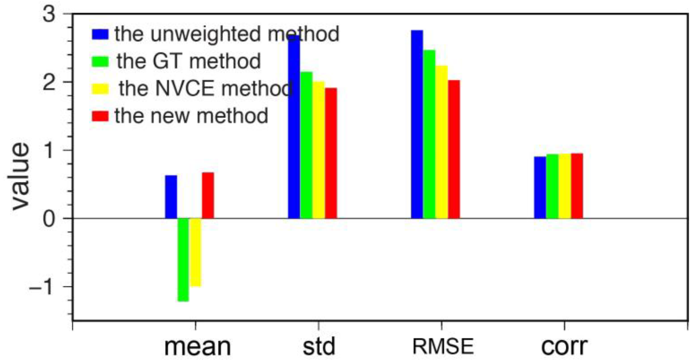
4.2. Average Performance

For the perspective of quantitative evaluation, we calculated the mean, std, root mean-square error (RMSE) and correlation (corr) between the simulated velocity and the estimated results, as shown in Figure 8. Compared with the unweighted, the GT and the NVCE methods, the new method had improvements of 32.21–44.35%, 4.26–28.82%, 9.52–26.52% and 0.42–5.28% in mean, std, RMSE and corr, respectively. These further demonstrate the new method has a better performance in the weighting of each pixel.

4.3. Validation of the Performances with GNSS Datasets

In order to intuitively analyze, regarded GPS-derived truth and RMSEs of each GPS point under these four weighting methods can be obtained. Figure 9 describes the comparison results from these four weighting methods. It is obvious that the RMSE of the new method is smaller than the other three weighting method in most GPS stations. The average RMSEs of these four weighting method are 1.79, 1.80, 1.80 and 1.66 cm, respectively. This also illustrates the improvement of the new weighting method. This may be because the new weighting method does not take into account the effect of covariance of atmospheric turbulence in spatial domain. As mentioned in previous study, it is regarded as a big challenge at present [41].
In general, the accuracy of the results without weighting was the lowest among the four methods tested. The GT method makes full use of the geometric relationship between the N   SAR images and M   interferograms, and this algorithm is simple and easy to implement. However, this method considers that each pixel in the same interferogram is polluted by noise to the same degree. This assumption makes all pixels in the same interferogram have an equal weight. Based on the GT method, the NVCE weighting method focuses on estimating the influence of atmospheric turbulence on the weight of each pixel. However, this method ignores the correlation of decorrelation noise in time domain. The proposed new weighting method avoids this limitation, and the accuracy of the results by using this new method is increased by 7.49%, 7.91% and 8.24%, respectively.
Although the performance of the new method outperforms than traditional methods and it can be applied in SBAS-InSAR without external data, the effect of atmospheric turbulence covariance in spatial domain is neglected. It is a big challenge at present as many previous studies pointed out. Therefore, we will focus on calculating the VCM of atmospheric turbulence in temporal and spatial domain by developing optimization algorithms in the future.

5. Conclusions

We propose a new weighting method which accounts for the atmospheric turbulence delay and inter-epoch decorrelation noise in SBAS-InSAR. Simulated and real experimental results demonstrate that the proposed method can effectively improve the accuracy of SBAS-InSAR measurement and the uncertainty information of the estimated parameters. Meanwhile, the new method relies entirely on the interferogram itself instead of external data to reduce the influence of atmospheric turbulence delay and decorrelation noises. Furthermore, the new method is not restricted by conditions such as the topography and climate of the study area. Therefore, it can be further implemented as a routine work and inserted in the current SBAS-InSAR algorithm.
In addition, the surface deformation of Hawaii caused by crustal movement (i.e., volcanoes and earthquakes) has been monitored by using the new weighting method and it is more consistent with GPS measurements than traditional methods. This illustrates the reliability of the algorithm proposed in this study; on the other hand, it can provide a certain reference value for Hawaiian volcanic activity.

Author Contributions

Conceptualization, M.D., B.X. and Z.L.; methodology, M.D.; software, B.X. and Z.L.; validation, M.D., B.X., W.W. and Y.C.; formal analysis, M.D., J.L. and G.W.; investigation, W.W. and J.H.; resources, M.D. and Y.C.; data curation, M.D. and B.X.; writing-original draft preparation, M.D. and Z.L.; writing—review and editing, B.X. and Z.L.; supervision, W.W. and B.X.; project administration, B.X. and Z.L.; funding acquisition, B.X. and Z.L. All authors have read and agreed to the published version of the manuscript.

Funding

This research was funded by the National Science Fund for Distinguished Young Scholars, grant number 41925016; the National Key R&D Program of China, grant number 2018YFC1503603; the National Natural Science Foundation of China, grant number 41804008; and the Leading Talents Plan of Central South University, grant number 506030101.

Acknowledgments

The Sentinel-1 data were supplied by the European Space Agency and Global Positioning System data were downloaded from the Nevada geodetic Laboratory.

Conflicts of Interest

The authors declare no conflict of interest.

Appendix A

Figure A1. Comparison between GPS daily observations in line of sight (LOS) direction (gray dots) and InSAR-derived time series displacement (red triangles) from four different weighting methods at 26 GPS stations in Figure 8. Each row represents a GPS site and the four columns represent the results from the unweighted, the GT, the NVCE and the new method, respectively.
Remotesensing 12 02557 g0a1aRemotesensing 12 02557 g0a1bRemotesensing 12 02557 g0a1cRemotesensing 12 02557 g0a1d

References

  1. Duan, M.; Xu, B.; Li, Z.W.; Cao, Y.M.; Hu, J.; Xu, W.B.; Wei, J.C.; Feng, G.C. Non-differential water vapor estimation from SBAS-InSAR. J. Atmos. Sol. Terr. Phys. 2020, 204, 105284. [Google Scholar] [CrossRef]
  2. Mateus, P.; Miranda, P.M.A.; Nico, G.; Catalão, J.; Pinto, P.; Tomé, R. Assimilating InSAR maps of water vapor to improve heavy rainfall forecasts: A case study with two successive storms. J. Geophys. Res. Atmos. 2018, 123, 3341–3355. [Google Scholar] [CrossRef]
  3. Miranda, P.M.; Mateus, P.; Nico, G.; Catalão, J.; Tomé, R.; Nogueira, M. InSAR meteorology: High-resolution geodetic data can increase atmospheric predictability. Geophys. Res. Lett. 2019, 46, 2949–2955. [Google Scholar] [CrossRef] [Green Version]
  4. Tang, W.; Liao, M.; Zhang, L.; Li, W.; Yu, W. High-spatial-resolution mapping precipitable water vapor using SAR interferograms, GPS observations and ERA-Interim reanalysis. Atmos. Meas. Tech. 2016, 9, 4487–4501. [Google Scholar] [CrossRef] [Green Version]
  5. Youhei, K.; Masanobu, S.; Masato, F. InSAR observation and numerical modeling of the water vapor signal during a heavy rain: A case study of the 2008 Seino event, central Japan. Geophys. Res. Lett. 2013, 40, 4740–4744. [Google Scholar]
  6. Du, Y.N.; Zhang, L.; Feng, G.C.; Lu, Z.; Sun, Q. On the accuracy of topographic residuals retrieved by MTInSAR. IEEE Trans. Geosci. Remote Sens. 2016, 55, 1053–1065. [Google Scholar] [CrossRef]
  7. Hu, J.; Li, Z.W.; Ding, X.L.; Zhu, J.J.; Zhang, L.; Sun, Q. Resolving three-dimensional surface displacements from InSAR measurements: A review. Earth Sci. Rev. 2014, 133, 1–17. [Google Scholar] [CrossRef]
  8. Yang, Z.F.; Li, Z.W.; Zhu, J.J.; Preusse, A.; Hu, J.; Feng, G.C.; Yi, H.W.; Papst, M. Time-series 3D Mining-Induced Large Displacement Modeling and Roubst Estimation from a Single-Geometry SAR Amplitude Dataset. IEEE Trans. Geosci. Remote Sens. 2018, 56, 3600–3610. [Google Scholar] [CrossRef]
  9. Liu, J.H.; Hu, J.; Li, Z.W.; Zhu, J.J.; Sun, Q.; Gan, J. A method for measuring 3-D surface deformations with InSAR based on strain model and variance component estimation. IEEE Trans. Geosci. Remote Sens. 2018, 56, 239–250. [Google Scholar] [CrossRef]
  10. Liu, J.H.; Hu, J.; Xu, W.B.; Li, Z.W.; Zhu, J.J.; Ding, X.L.; Zhang, L. Complete three-dimensional coseismic deformation field of the 2016 central tottori earthquake by integrating left- and right-looking InSAR observations with the improved SM-VCE method. J. Geophys. Res. Solid Earth 2019, 124, 12099–12115. [Google Scholar] [CrossRef] [Green Version]
  11. Wu, S.B.; Zhang, L.; Ding, X.L.; Perissin, D. Pixel-wise MTInSAR estimator for integration of coherent point selection and unwrapped phase vector recovery. IEEE Trans. Geosci. Remote Sens. 2019, 57, 2659–2668. [Google Scholar] [CrossRef]
  12. Wu, S.B.; Yang, Z.F.; Ding, X.L.; Zhang, B.C.; Zhang, L.; Lu, Z. Two decades settlement of Hong Kong international airpory measured with multi-temporal InSAR. Remote Sens. Environ. 2020, 248, 111976. [Google Scholar] [CrossRef]
  13. Zebker, H.A.; Rosen, P.A.; Hensley, S. Atmospheric effects in interferometric synthetic aperture radar surface deformation and topographic maps. J. Geophys. Res. Solid Earth 1997, 102, 7547–7563. [Google Scholar] [CrossRef]
  14. Hanssen, R.F. Radar Interferometry: Data Interpretation and Error Analysis; Springer Science & Business Media: Berlin, Germany, 2001. [Google Scholar]
  15. Li, Z.W.; Cao, Y.M.; Wie, J.C.; Duan, M.; Wu, L.X.; Hou, J.X.; Zhu, J.J. Time-Series InSAR Ground Deformation Monitoring: Atmospheric Delay Modeling and Estimating. Earth Sci. Rev. 2019, 192, 258–284. [Google Scholar] [CrossRef]
  16. Qu, C.Y.; Shan, X.J.; Zhang, G.H.; Song, X.G.; Guo, L.M. Influence of interferometric baseline on measurements of seismic deformation: A case study on the 1997 mani, tibet m 7.7 earthquake. Seismol. Geol. 2012, 34, 672–680. [Google Scholar]
  17. Xu, B.; Li, Z.W.; Zhu, Y.; Shi, J.C.; Feng, G.C. SAR interferometric baseline refinement based on flat-earth phase without a ground control point. Remote Sens. 2020, 12, 233. [Google Scholar] [CrossRef] [Green Version]
  18. Xu, B.; Li, Z.W.; Zhu, Y.; Shi, J.C.; Feng, G.C. Kinematic coregistration of Sentinel-1 TOPSAR images based on sequential least squares adjustment. IEEE J. Sel. Top. Appl. Earth Observ. Remote Sens. 2020, 13, 3083–3093. [Google Scholar] [CrossRef]
  19. Xu, W.B.; Li, Z.W.; Ding, X.L.; Zhu, J.J. Interpolating Atmospheric Water Vapor Delay by Incorporating Terrain Elevation Information. J. Geod. 2012, 85, 555–564. [Google Scholar] [CrossRef]
  20. Li, Z.W.; Xu, W.B.; Feng, G.C.; Hu, J.; Wang, C.C.; Ding, X.L.; Zhu, J.J. Correcting atmospheric effects on InSAR with MERIS water vapor data and elevation-dependent interpolation model. Geophys. J. Int. 2012, 189, 898–910. [Google Scholar] [CrossRef] [Green Version]
  21. Liang, H.Y.; Zhang, L.; Ding, X.L.; Lu, Z.; Li, X. Toward Mitigating Stratified Tropospheric Delays in Multitemporal InSAR: A Quadtree Aided Joint Model. IEEE Trans. Geosci. Remote Sens. 2018, 57, 291–303. [Google Scholar] [CrossRef]
  22. Shirzaei, M.; Walter, T.R. Estimating the effect of satellite orbital error using wavelet-based robust regression applied to insar deformation data. IEEE Trans. Geosci. Remote Sens. 2011, 49, 4600–4605. [Google Scholar] [CrossRef]
  23. Xu, B.; Li, Z.W.; Wang, Q.J.; Jiang, M.; Zhu, J.J.; Ding, X.L. A Refine Strategy for Removing Composite Errors of SAR Interferogram. IEEE Trans. Geosci. Remote Sens. Lett. 2011, 11, 143–147. [Google Scholar] [CrossRef]
  24. Li, Z.H.; Fielding, E.J.; Cross, P.; Preusker, R. Advanced inSAR atmospheric correction: MERIS/MODIS combination and stacked water vapor models. Int. J. Remote Sens. 2009, 30, 3343–3363. [Google Scholar] [CrossRef]
  25. Yu, C.; Li, Z.H.; Penna, N.T. Interferometric synthetic aperture radar atmospheric correction using a GPS-based iterative tropospheric decomposition model. Remote Sens. Environ. 2018, 204, 109–121. [Google Scholar] [CrossRef]
  26. Doin, M.P.; Lasserre, C.; Peltzer, G.; Cavalié, O.; Doubre, C. Corrections of stratified tropospheric delays in SAR interferometry: Validation with global atmospheric models. J. Appl. Geophys. 2009, 69, 35–50. [Google Scholar] [CrossRef]
  27. Jolivet, R.; Grandin, R.; Lasserre, C.; Doin, M.P.; Peltzer, G. Systematic InSAR tropospheric phase delay corrections from global meteorological reanalysis data. Geophys. Res. Lett. 2011, 38. [Google Scholar] [CrossRef] [Green Version]
  28. Azeriansyah, R.; Harintaka. Integration PS-InSAR and MODIS PWV data to monitor land subsidence in Semarang city 2015–2018. In Proceedings of the 1st International Conference on Geodesy, Geomatics, and Land Administration, Semarang, Indonesia, 24–25 July 2019; pp. 66–76. [Google Scholar]
  29. Xu, C.J.; Wang, H.; Jiang, G.Y. Study on crustal deformation of Wenchuan Ms8.0 earthquake using wide-swath ScanSAR and MODIS. Geod. Geodyn. 2011, 2, 1–6. [Google Scholar]
  30. Mateus, P.; Nico, G.; Catalão, J. Interpolating MERIS and GPS measurements of precipitable water vapor (PWV) to estimate atmospheric phase delay maps. Remote Sens. Clouds Atmos. XV 2010, 7827, 782713. [Google Scholar]
  31. Puyssegur, B.; Michek, R.; Avouac, P. Tropospheric Phase Delay in Interferometric Synthetic Aperture Radar Estimated from Meteorological Model and Multispectral imagery. J. Geophys. Res. Solid Earth 2007, 112, B05419. [Google Scholar] [CrossRef] [Green Version]
  32. Gong, W.; Meyer, F.; Webley, P.W.; Morton, D.; Liu, S. Performance analysis of atmospheric correction in InSAR data based on the Weather Research and Forecasting Model (WRF). In Proceedings of the IEEE International Geoscience and Remote Sensing Symposium, Honolulu, HI, USA, 25–30 July 2010; pp. 2900–2903. [Google Scholar]
  33. Mateus, P.; Nico, G.; Catalão, J. Uncertainty assessment of the estimated atmospheric delay obtained by a numerical weather model (NMW). IEEE Trans. Geosci. Remote Sens. 2015, 53, 6710–6717. [Google Scholar] [CrossRef]
  34. Thomas, H.; Youhei, K.; Shingo, S.; Ryuichi, I.; Masato, F.; Tetsuro, K.; Yasuhiro, K. On the importance of accurately ray-traced troposphere corrections for Interferometric SAR data. J. Geod. 2010, 84, 537–546. [Google Scholar]
  35. Kinoshita, Y.; Furuya, M.; Hobiger, T.; Ichikawa, R. Are numerical weather model outputs helpful to reduce tropospheric delay signals in InSAR data? J. Geod. 2012, 87, 267–277. [Google Scholar] [CrossRef] [Green Version]
  36. Berardino, P.; Fornaro, G.; Lanari, R.; Sansosti, E. A new algorithm for surface deformation monitoring based on small baseline differential SAR interferograms. IEEE Trans. Geosci. Remote Sens. 2002, 40, 2375–2383. [Google Scholar] [CrossRef] [Green Version]
  37. Ferretti, A.; Prati, C.; Rocca, F. Nonlinear subsidence rate estimation using permanent scatterers in differential SAR interferometry. IEEE Trans. Geosci. Remote Sens. 2000, 38, 2202–2212. [Google Scholar] [CrossRef] [Green Version]
  38. Ferretti, A.; Prati, C.; Rocca, F. Permanent scatterers in SAR interferometry. IEEE Trans. Geosci. Remote Sens. 2001, 39, 8–20. [Google Scholar] [CrossRef]
  39. Bovenga, F.; Giacovazzo, V.M.; Refice, A.; Veneziani, N. Multichromatic analysis of InSAR data. IEEE Trans. Geosci. Remote Sens. 2013, 51, 4790–4799. [Google Scholar] [CrossRef]
  40. Biondi, F.; Clemente, C.; Orlando, D. An atmospheric phase screen estimation strategy based on multichromatic analysis for differential interferometric synthetic aperture radar. IEEE Trans. Geosci. Remote Sens. 2019, 57, 7269–7280. [Google Scholar] [CrossRef]
  41. González, P.J.; Fernández, J. Error Estimation in Multitemporal InSAR Deformation Time Series, with Application to Lanzarote, Canary Islands. J. Geophys. Res. Solid Earth 2011, 116, B10404. [Google Scholar] [CrossRef] [Green Version]
  42. Cao, Y.M.; Li, Z.W.; Wei, J.C.; Duan, M.; Feng, G.C. Stochastic Modeling for Time Series InSAR: With Emphasis on Atmospheric Effects. J. Geod. 2018, 92, 185–204. [Google Scholar] [CrossRef]
  43. Reinisch, E.C.; Cardiff, M.; Feigl, K.L. Graph Theory for Analyzing Pair-Wise Data: Application to Geophysical Model Parameters Estimated from Interferometric Synthetic Aperture Radar Data at Okmok Volcano, Alaska. J. Geod. 2018, 91, 9–24. [Google Scholar] [CrossRef] [Green Version]
  44. Cressie, N. Statistics for Spatial Data; John and Wiley and Sons: Hoboken, NJ, USA, 1993. [Google Scholar]
  45. Strozzi, T.; Wegmuller, U.; Werner, C.; Wiesmann, A. Measurement of slow uniform surface displacement with mm/year accuracy. In Proceedings of the IGARSS, Honolulu, HI, USA, 24–28 July 2000; Volume 5, pp. 24–28. [Google Scholar]
  46. Zebker, H.A.; Villasenor, J. Decorrelation in interferometric radar echos. IEEE Trans. Geosci. Remote Sens. 1992, 30, 950–959. [Google Scholar] [CrossRef] [Green Version]
  47. Esfahany, S.S. Exploitation of Distributed Scatterers in Synthetic Aperture Radar Interferometry. Ph.D. Thesis, Delft University of Technology, Delft, The Netherland, 2017. [Google Scholar]
  48. Chen, K.J.; Smith, J.D.; Avouac, J.P.; Liu, Z.; Song, Y.T.; Gualandi, A. Triggering of The Mw 7.2 Hawaii Earthquake of 4 May 2018 by A Dike Intrusion. Geophys. Res. Lett. 2019, 46, 2503–2510. [Google Scholar] [CrossRef]
  49. Casu, F.; Lanari, R.; Sansosti, E.; Poland, M.; Miklius, A.; Solaro, G.; Tzzani, P. SBAS-InSAR analysis of surface deformation at Mauna Loa and Kilauea volcanoes in Hawaii. In Proceedings of the 2009 IEEE International Geoscience and Remote Sensing Symposium, Cape Town, South Africa, 12–17 July 2009; Volume 4, pp. 41–44. [Google Scholar]
  50. Gui, Q.; Guo, J. Study on methods for solving ill-condition equations. J. Geod. Geodyn. 2004, 24, 15–18. [Google Scholar]
Figure 1. (a) N SAR images. (b) M interferograms. (c) Spatial structure of SBAS-InSAR. Each grid in (a) and (b) represents a pixel. The red pixel denotes the reference point in SBAS-InSAR. Black dots (e.g., s i ) and black edges (e.g., I i ) in (c) represent SAR images and interferograms formed by the corresponding SAR images. Bp and Bt are perpendicular and time baselines, respectively.
Remotesensing 12 02557 g001
Figure 2. (a) The simulated mean deformation velocity and (b) the spatial-temporal baselines of the interferograms used in the simulation experiment; green dots represent the image time epochs and blue edges represent the interferograms.
Remotesensing 12 02557 g002
Figure 3. (a,d,g,j) Estimated deformation velocities by using the unweighted method, the GT method, the NVCE method and the new method, respectively. (b,e,h,k) The differences between the simulated deformation velocity and the ones estimated from the four weighting methods respectively. (c,f,i,l) The corresponding histogram of the second column.
Remotesensing 12 02557 g003
Figure 4. (a) The black rectangle represents the study area, the red star is the reference point and the blue dot denotes the location of MOKP site. (b) The spatial-temporal baselines of the interferograms used in the real data experiment; green dots represent the image time epochs and blue edges represent the interferograms.
Remotesensing 12 02557 g004
Figure 5. (a) The variance-covariance matrix (VCM) of the atmospheric turbulence. (b) VCM of the decorrelation noise. (c) The total VCM and (d) the corresponding weight of the MOPK site.
Remotesensing 12 02557 g005
Figure 6. Comparison between InSAR-derived time series displacement (red triangles with black error bars) and GPS daily observations in LOS direction (gray dots) at site MOKP. (ad) The results from unweighted method, the GT method, the NVCE and the new method, respectively.
Remotesensing 12 02557 g006
Figure 7. (ad) Mean deformation velocity of the study area by using the unweighted method, the GT method, the NVCE method and the new weighting method, respectively. Blue triangles represent the 27 GPS stations which were used for validation and the corresponding name are AINP, ALAL, ALEP, ANIP, APNT, BLBP, KAON, KEAW, KHKU, KULE, MLCC, MLES, MLPR, MLRD, MLSP, MOKP, NIHO, NUPM, PG2R, PHAN, PIIK, PMAU, PUKA, SLPC, STEP, TOUO and YEEP, respectively.
Remotesensing 12 02557 g007
Figure 8. Statistical quantitative comparison: the vertical movement estimations derived from the unweighted method (blue), the GT method (green), the NVCE method (yellow) and the new method (red) in mean, std, RMSE and corr, respectively.
Remotesensing 12 02557 g008
Figure 9. RMSEs of time series displacement under the unweighted (purple triangles), the GT (green dots), the NVCE (blue rectangles) and the new method (red stars), respectively.
Remotesensing 12 02557 g009
Table 1. Comparison of the new and NVCE methods in std, kurtosis and skewness.
Methodstd(mm/a)KurtosisSkewness
The NVCE method2.013.53−0.28
The new method1.913.23−0.06
Table 2. Basic parameters of the Scentinel-1A SAR acquisitions.
NumberOrbit ModelOrbit NumberImaging TimeTime Baseline (Day)Perpendicular Baseline (m)
1Descending090382018-01-0500
2Descending093882018-01-2924−66.35
3Descending097382018-02-2248−142.10
4Descending100882018-03-1872−60.95
5Descending104382018-04-1196−38.77
6Descending107882018-05-05120−84.43
7Descending109632018-05-17132−104.36
8Descending111382018-05-29144−115.50
9Descending113132018-06-10156−58.11
10Descending114882018-06-22168−112.54
11Descending116632018-07-04180−39.20
12Descending118382018-07-16192−151.86
13Descending120132018-07-28204−74.30
14Descending121882018-08-09216−127.93
15Descending123632018-08-21228−59.77
16Descending125382018-09-02240−88.92
17Descending127132018-09-14252−70.85
18Descending128882018-09-26264−120.01
19Descending130632018-10-0827611.81
20Descending132382018-10-20288−22.91
21Descending134132018-11-01300−15.14
22Descending135882018-11-1331227.40
23Descending248342018-12-01330−77.53
24Descending250092018-12-13342−130.78

