Open-Surface River Extraction Based on Sentinel-2 MSI Imagery and DEM Data: Case Study of the Upper Yellow River
Abstract
:1. Introduction
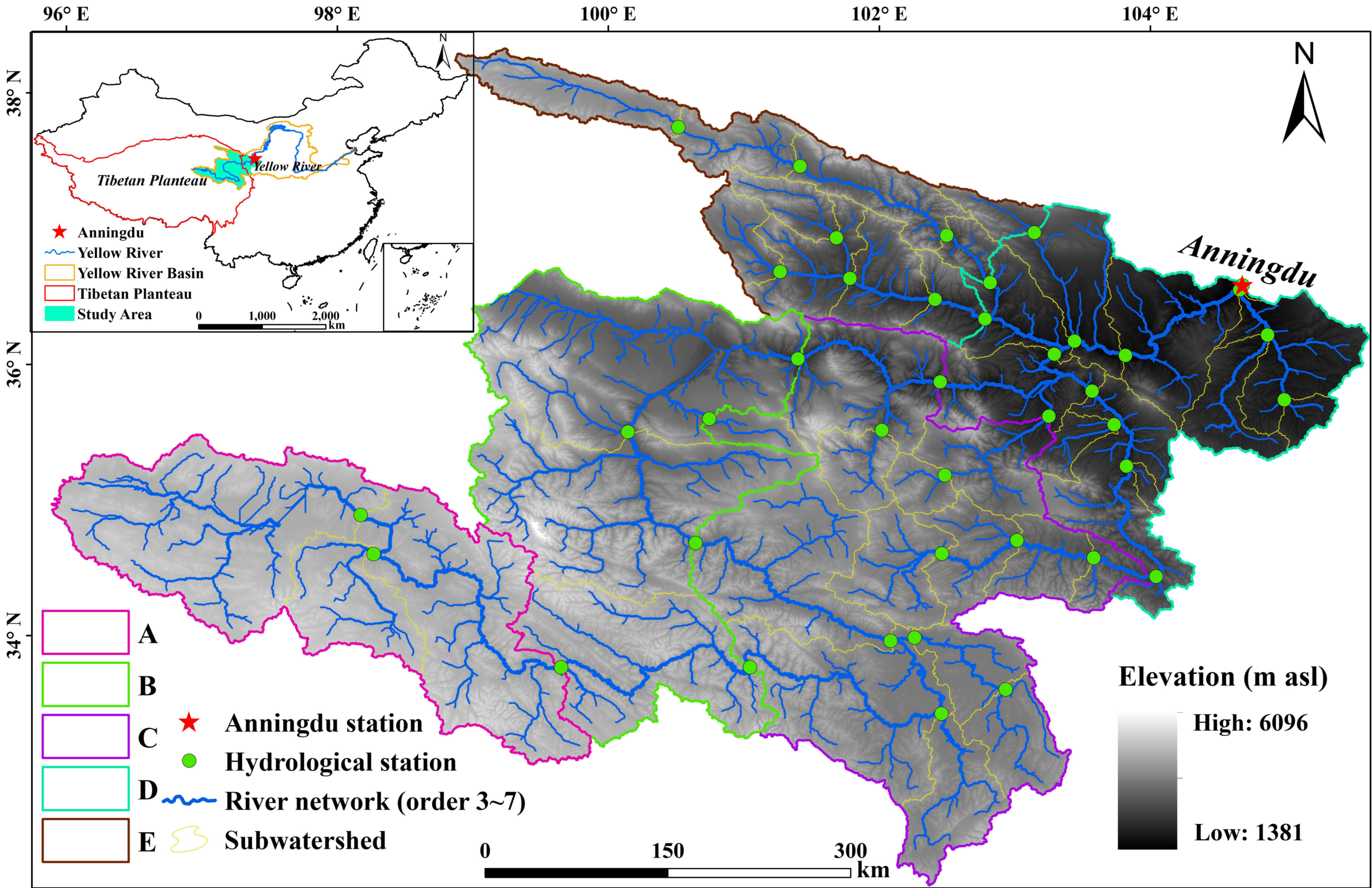
2. Study Area and Data
2.1. Study Area
2.2. Data
2.2.1. Sentinel-2 MSI Imagery
2.2.2. River Network from DEM
2.2.3. Hydrological Station Data
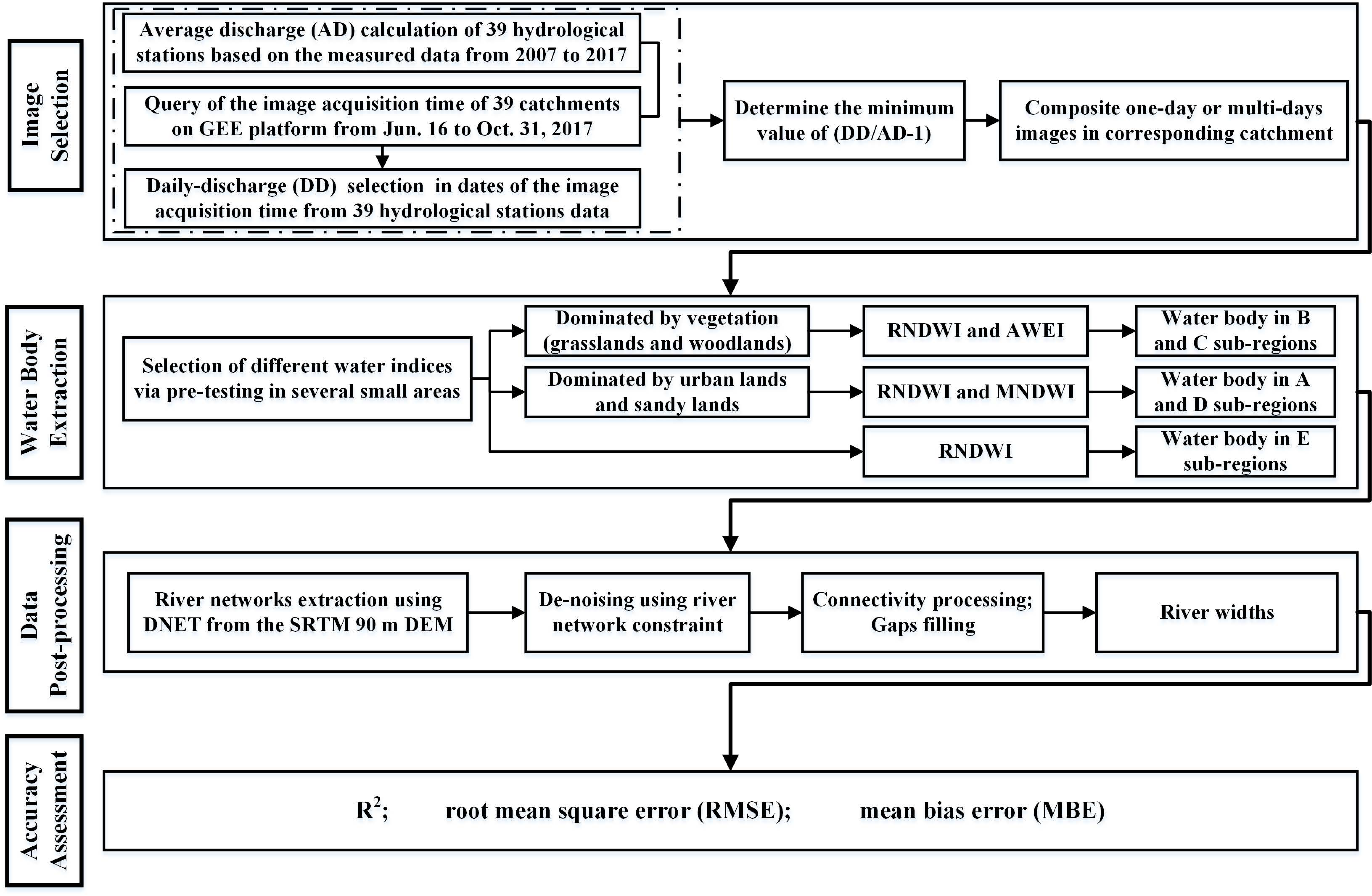
3. Methods
3.1. Data Pre-Processing
3.1.1. Study Area Subdivision
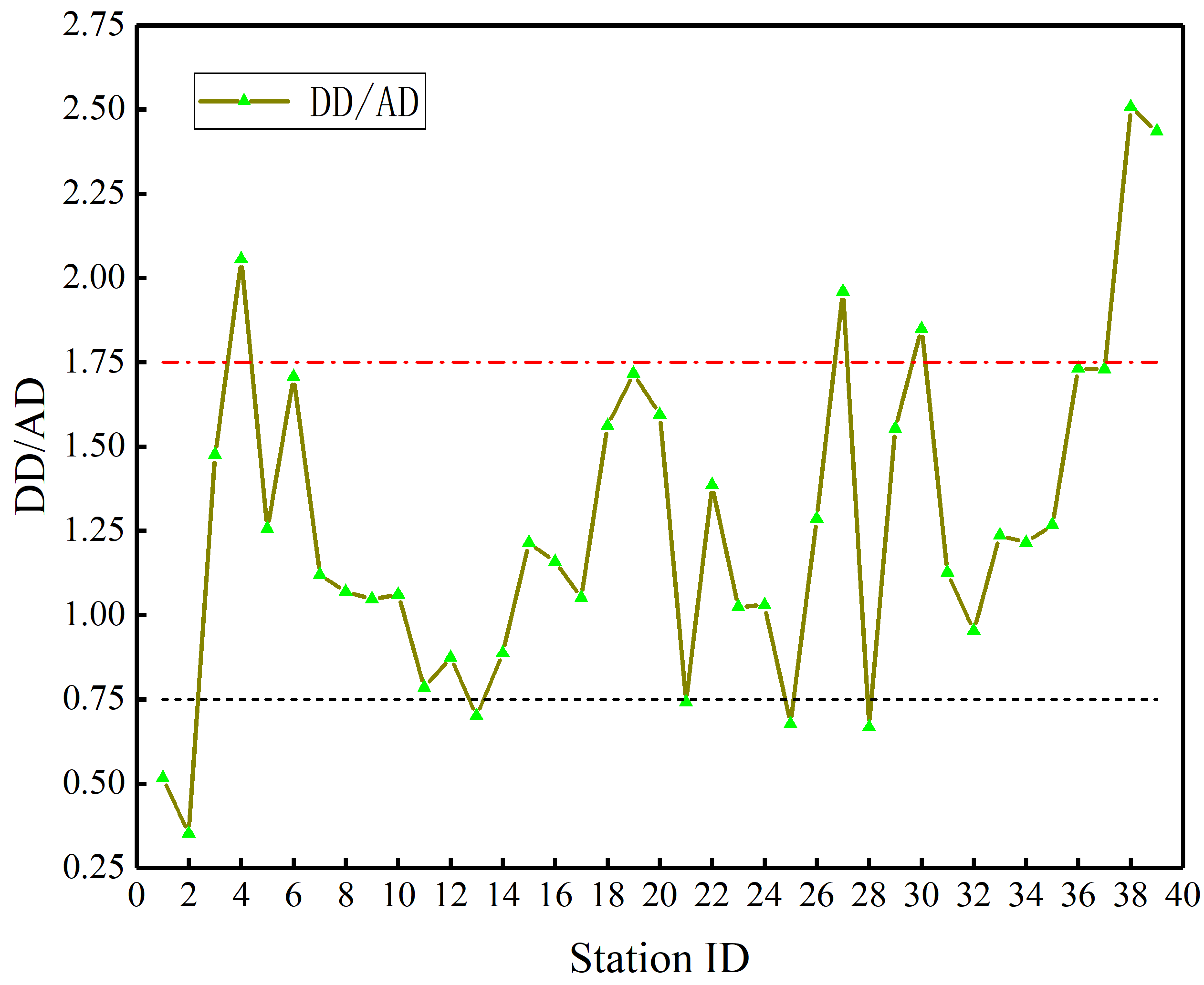
3.1.2. Discharge Calculation and Image Selection
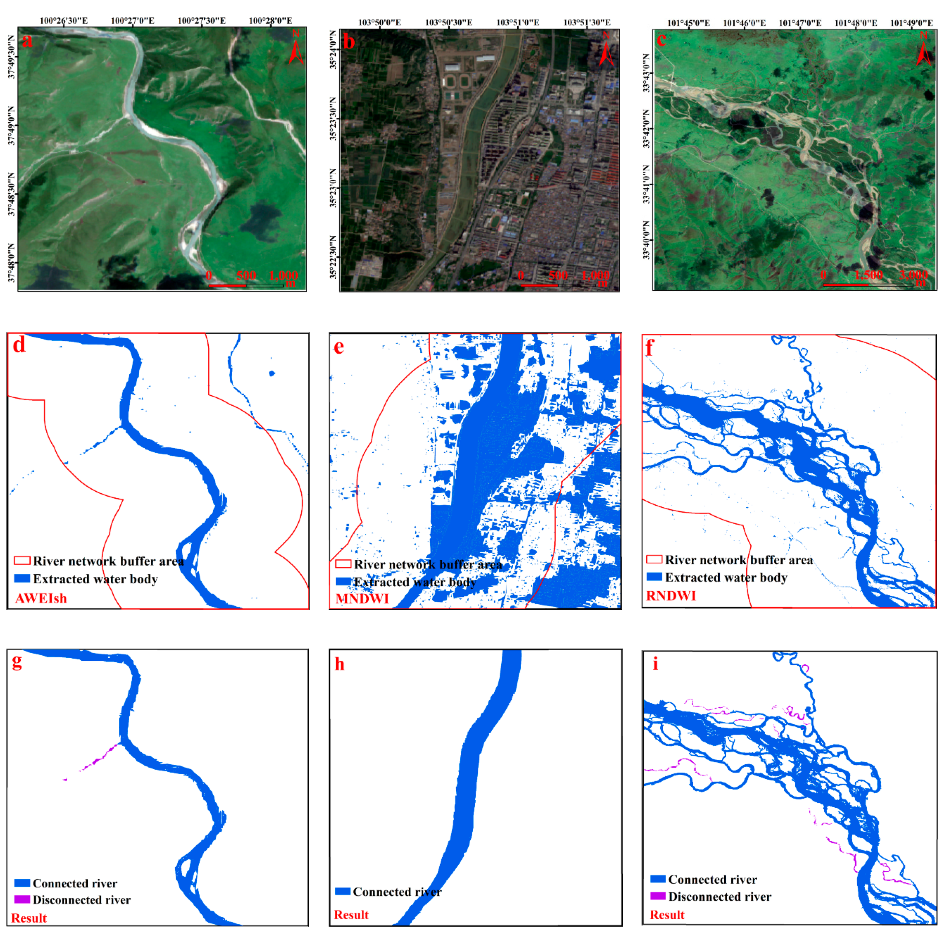
3.1.3. Water Index Selection
3.1.4. Water Body Extraction
3.2. Data Post-Processing
3.2.1. De-Noising Based on DEM
3.2.2. Connectivity Processing
3.2.3. Map Generalization
3.3. Accuracy Assessment
4. Results
4.1. Spatial Distribution of Water Bodies
4.2. River Extraction Results from Sentinel-2
4.3. River Width Estimation
5. Discussion
6. Conclusions
Author Contributions
Funding
Acknowledgments
Conflicts of Interest
References
- Lake, P.S. Ecological effects of perturbation by drought in flowing waters. Freshw. Biol. 2003, 48, 1161–1172. [Google Scholar] [CrossRef]
- Alderman, K.; Turner, L.R.; Tong, S.L. Floods and human health: A systematic review. Remote Sens. Environ. 2012, 140, 23–35. [Google Scholar] [CrossRef] [PubMed] [Green Version]
- Wei, J.; Wei, Y.P.; Western, A. Evolution of the societal value of water resources for economic development versus environmental sustainability in Australia from 1843 to 2011. Glob. Environ. Chang. Hum. Policy Dimens. 2017, 42, 82–92. [Google Scholar] [CrossRef]
- Sun, S.A.; Bao, C.; Fang, C.L. Freshwater use in China: Relations to economic development and natural water resources availability. Int. J. Water Resour. Dev. 2020, 36, 1–19. [Google Scholar] [CrossRef]
- Song, G.F. Evaluation on water resources and water ecological security with 2-tuple linguistic information. Int. J. Knowl. Based Intell. Eng. Syst. 2019, 23, 1–8. [Google Scholar] [CrossRef]
- Durand, M.; Gleason, C.J.; Garambols, P.A.; Bjerklie, D.; Smith, L.C.; Roux, H.; Rodriguez, E.; Bates, P.D.; Pavelsky, T.M.; Monnier, J.; et al. An inter comparison of remote sensing river discharge estimation algorithms from measurements of river height, width, and slope. Water Resour. Res. 2016, 52, 4527–4549. [Google Scholar] [CrossRef] [Green Version]
- Gleason, C.J.; Smith, L.C. Toward global mapping of river discharge using satellite images and at-many-stations hydraulic geometry. Proc. Natl. Acad. Sci. USA 2014, 111, 4788–4791. [Google Scholar] [CrossRef] [PubMed] [Green Version]
- Neal, J.; Schumann, G.; Bates, P. A subgrid channel model for simulating river hydraulics and floodplain inundation over large and data sparse areas. Water Resour. Res. 2012, 48, W11506. [Google Scholar] [CrossRef]
- Giustarini, L.; Hostache, R.; Matgen, P.; Schumann, G.J.P. A change detection approach to flood mapping in urban areas using TerraSAR-X. IEEE Trans. Geosci. Remote Sens. 2013, 51, 2417–2430. [Google Scholar] [CrossRef] [Green Version]
- Allen, G.H.; Pavelsky, T.M. Global extent of rivers and streams. Science 2018, 361, 585–587. [Google Scholar] [CrossRef] [Green Version]
- Nsubuga, F.W.N.; Botai, J.O.; Olwoch, J.M.; Rautenbach, C.J.W.; Kalumba, A.M.; Tsela, P.; Adeola, A.M.; Sentongo, A.A.; Mearns, K.F. Detecting changes in surface water area of Lake Kyoga sub-basin using remotely sensed imagery in a changing climate. Theor. Appl. Clim. 2017, 127, 327–337. [Google Scholar] [CrossRef] [Green Version]
- Pekel, J.F.; Cottam, A.; Gorelick, N.; Belward, A.S. High-resolution mapping of global surface water and its long-term changes. Nature 2016, 540, 418–422. [Google Scholar] [CrossRef] [PubMed]
- Ijaz, M.W.; Siyal, A.A.; Mahar, R.B.; Ahmed, W.; Anjum, M.N. Detection of hydromorphologic characteristics of Indus River estuary, Pakistan, using satellite and field data. Arab. J. Sci. Eng. 2017, 42, 2539–2558. [Google Scholar] [CrossRef]
- Wang, C.X.; Pavlowsky, R.T.; Huang, Q.Y.; Chang, C. Channel bar feature extraction for a mining-contaminated river using high-spatial multispectral remote-sensing imagery. Gisci. Remote Sens. 2016, 53, 283–302. [Google Scholar] [CrossRef]
- Lague, D. The stream power river incision model: Evidence, theory, and beyond. Earth Surf. Process. Landf. 2014, 39, 38–61. [Google Scholar] [CrossRef]
- Shen, Z.F.; Xia, L.G.; Li, J.L.; Luo, J.C.; Hu, X.D. Automatic and high-precision extraction of rivers from remotely sensed images with Gaussian normalized water index. J. Image Graph. 2013, 18, 421–428. [Google Scholar]
- Zeng, C.Q.; Bird, S.; Luce, J.J.; Wang, J.F. A natural-rule-based-connection (NRBC) method for river network extraction from high-resolution imagery. Remote Sens. 2015, 7, 14055–14078. [Google Scholar] [CrossRef] [Green Version]
- Ling, F.; Boyd, D.; Ge, Y.; Foody, G.M.; Li, X.D.; Wang, L.H.; Zhang, Y.H.; Shi, L.F.; Shang, C.; Li, X.Y.; et al. Measuring river wetted width from remotely sensed imagery at the subpixel scale with a deep convolutional neural network. Water Resour. Res. 2019, 55, 5631–5649. [Google Scholar] [CrossRef]
- Yan, D.H.; Wang, K.; Qin, T.L.; Weng, B.S.; Wang, H.; Bi, W.X.; Li, X.N.; Li, M.; Lv, Z.Y.; Liu, F.; et al. A data set of global river networks and corresponding water resources zones divisions. Sci. Data 2019, 6, 219. [Google Scholar] [CrossRef] [Green Version]
- Wu, T.; Li, J.Y.; Li, T.J.; Sivakumar, B.; Zhang, G.; Wang, G.Q. High-efficient extraction of drainage networks from digital elevation models constrained by enhanced flow enforcement from known river maps. Geomorphology 2019, 340, 184–201. [Google Scholar] [CrossRef]
- Kirchner, K.; Kolar, J.; Plachy, S. Satellite detection of water surfaces in Northwestern Bohemia. Sov. J. Remote Sens. 1986, 5, 63–68. [Google Scholar]
- Jupp, D.L.B.; Kirk, J.T.O.; Harris, G.P. Detection, identification and mapping of cyanobacteria-using remote-sensing to measure the optical-quality of turbid inland waters. Aust. J. Mar. Freshw. Res. 1994, 45, 801–828. [Google Scholar] [CrossRef]
- Zhou, H.P.; Hong, J.; Xiao, Z.Y.; Yu, S.Q.; Chang, J. Water quality assessment and change detection in urban wetland using high spatial resolution satellite imagery. Proc. of SPIE 2007, 6752, 67522G. [Google Scholar]
- Dandawate, Y.H.; Kinlekar, S. Rivers and coastlines detection in multispectral satellite images using level set method and modified chan vese algorithm. In Proceedings of the 2013 2nd International Conference on Advanced Computing, Networking and Security, Mangalore, India, 15–17 December 2013; pp. 41–46. [Google Scholar]
- Almaazmi, A. Water bodies extraction from high resolution satellite images using water indices and optimal threshold. In Proceedings of the Image & Signal Processing for Remote Sensing XXII International Society for Optics and Photonics, Edinburgh, UK, 26–29 September 2016; Volume 10004, p. 100041J. [Google Scholar]
- Chen, Y.; Fan, R.S.; Yang, X.C.; Wang, J.X.; Latif, A. Extraction of urban water bodies from high-resolution remote-sensing imagery using deep learning. Water 2018, 10, 585. [Google Scholar] [CrossRef] [Green Version]
- Huang, Q.; Long, D.; Du, M.D.; Zeng, C.; Qiao, G.; Li, X.D.; Hou, A.Z.; Hong, Y. Discharge estimation in high-mountain regions with improved methods using multisource remote sensing: A case study of the Upper Brahmaputra River. Remote Sens. Environ. 2018, 219, 115–134. [Google Scholar] [CrossRef]
- Wang, X.X.; Xiao, X.M.; Zou, Z.H.; Chen, B.Q.; Ma, J.; Dong, J.W.; Doughty, R.B.; Zhong, Q.Y.; Qin, Y.W.; Dai, S.Q.; et al. Tracking annual changes of coastal tidal flats in China during 1986–2016 through analyses of Landsat images with Google Earth Engine. Remote Sens. Environ. 2020, 238, 110987. [Google Scholar] [CrossRef]
- Deng, Y.; Jiang, W.G.; Tang, Z.H.; Ling, Z.Y.; Wu, Z.F. Long-term changes of open-surface water bodies in the Yangtze River basin based on the Google Earth Engine cloud platform. Remote Sens. 2019, 11, 2213. [Google Scholar] [CrossRef] [Green Version]
- Mcfeeters, S.K. The use of the normalized difference water index (NDWI) in the delineation of open water features. Int. J. Remote Sens. 1996, 17, 1425–1432. [Google Scholar] [CrossRef]
- Ouma, Y.O.; Tateishi, R. A water index for rapid mapping of shoreline changes of five East African Rift Valley lakes: An empirical analysis using Landsat TM and ETM+ data. Int. J. Remote Sens. 2006, 27, 3153–3181. [Google Scholar] [CrossRef]
- Fisher, A.; Flood, N.; Danaher, T. Comparing Landsat water index methods for automated water classification in eastern Australia. Remote Sens. Environ. 2016, 175, 167–182. [Google Scholar] [CrossRef]
- Asmadin; Siregar, V.P.; Sofian, I.; Jaya, I.; Wijanarto, A.B. Feature extraction of coastal surface inundation via water index algorithms using multispectral satellite on North Jakarta. IOP Conf. Ser. Earth Environ. Sci. 2018, 176, 012032. [Google Scholar] [CrossRef]
- Kebede, M.G.; Wang, L.; Li, X.P.; Hu, Z.D. Remote sensing-based river discharge estimation for a small river flowing over the high mountain regions of the Tibetan Plateau. Int. J. Remote Sens. 2020, 41, 3322–3345. [Google Scholar] [CrossRef]
- Bing, L.F.; Shao, Q.Q.; Liu, J.Y. Runoff characteristic in flood and dry seasons based on wavelet analysis in source regions of Yangtze and Yellow Rivers. J. Geogr. Sci. 2012, 22, 261–272. [Google Scholar] [CrossRef] [Green Version]
- ESA. Available online: https://www.esa.int/ (accessed on 10 February 2020).
- Drusch, M.; Del Bello, U.; Carlier, S.; Colin, O.; Fernandez, V.; Gascon, F.; Hoersch, B.; Isola, C.; Laberinti, P.; Martimort, P.; et al. Sentinel-2: ESA’s optical high-resolution mission for GMES operational services. Remote Sens. Environ. 2012, 120, 25–36. [Google Scholar] [CrossRef]
- ESA Sentinel Online. Available online: https://earth.esa.int/web/sentinel/missions/sentinel-2/overview (accessed on 10 February 2020).
- Bai, R.; Li, T.J.; Huang, Y.F.; Li, J.Y.; Wang, G.Q. An efficient and comprehensive method for drainage network extraction from DEM with billions of pixels using a size-balanced binary search tree. Geomorphology 2015, 238, 56–67. [Google Scholar] [CrossRef]
- Bai, R. Large Scale Drainage Network Extraction and River Structure Rules; Tsinghua University: Beijing, China, 2015. (In Chinese) [Google Scholar]
- Strahler, A.N. Quantitative analysis of watershed geomorphology. Trans. Am. Geophys. Union 1957, 38, 913–920. [Google Scholar] [CrossRef] [Green Version]
- Yellow River Water Resources Commission. Annual Hydrological Report: Upper Yellow River Basin (Hard Copy); Department of Hydrology, Ministry of Water Resources: Beijing, China, 2017. (In Chinese)
- Resource and Environment Data Cloud Platform. Land Use/Cover Change of China in 2015; Institute of Geographic Sciences and Natural Resources Research, CAS: Beijing, China, 2015. (In Chinese) [Google Scholar]
- Van den Berg, J.H. Prediction of alluvial channel pattern of perennial rivers. Geomorphology 1995, 12, 259–279. [Google Scholar] [CrossRef]
- Xu, H.Q. A study on information extraction of water body with the modified normalized difference water index (MNDWI). J. Remote Sens. 2005, 9, 589–595. [Google Scholar]
- Feyisa, G.; Meilby, H.; Fensholt, R.; Proud, S.R. Automated water extraction index: A new technique for surface water mapping using Landsat imagery. Remote Sens. Environ. 2014, 140, 23–35. [Google Scholar] [CrossRef]
- Cao, R.L.; Li, C.J.; Liu, L.Y.; Wang, J.H.; Yan, G.J. Extracting Miyun reservoir’s water area and monitoring its change based on a revised normalized different water index. Sci. Surv. Mapping 2008, 33, 158–160. [Google Scholar]
- Li, D.; Wu, B.S.; Chen, B.W.; Xue, Y.; Zhang, Y. Review of water body information extraction based on satellite remote sensing. J. Tsinghua Univ. (Sci. Technol.) 2020, 60, 147–161. [Google Scholar]
- Otsu, N. A threshold selection method from gray-level histograms. IEEE Trans. Syst. Man Cybern. 2007, 9, 62–66. [Google Scholar] [CrossRef] [Green Version]
- Zhai, K.; Wu, X.; Qin, Y.; Du, P. Comparison of surface water extraction performances of different classic water indices using OLI and TM imageries in different situations. Geo-Spat. Inf. Sci. 2015, 18, 32–42. [Google Scholar] [CrossRef]
- Rauf, A.; Ghumman, A.R. Impact assessment of rainfall-runoff simulations on the flow duration curve of the upper Indus River—A comparison of data-driven and hydrologic models. Water 2018, 10, 876. [Google Scholar] [CrossRef] [Green Version]
- Gilewski, P.; Nawalany, M. Inter-comparison of rain-gauge, radar, and satellite (IMERG GPM) precipitation estimates performance for rainfall-runoff modeling in a mountainous catchment in Poland. Water 2018, 10, 1665. [Google Scholar] [CrossRef] [Green Version]
- Yang, X.; Pavelsky, T.M.; Allen, G.H.; Donchyts, G. RivWidthCloud: An automated Google Earth Engine algorithm for river width extraction from remotely sensed imagery. IEEE Geosci. Remote Sens. Lett. 2020, 17, 217–221. [Google Scholar] [CrossRef]
- Cameron, A.C.; Windmeijer, F.A. An R-squared measure of goodness of fit for some common nonlinear regression models. J. Econom. 1997, 77, 329–342. [Google Scholar] [CrossRef]
- Singh, J.; Knapp, H.V.; Demissie, M. Hydrologic modeling of the Iroquois river watershed using HSPF and SWAT; Illinois State water survey contract report. J. Am. Water Resour. Assoc. 2005, 41, 343–360. [Google Scholar] [CrossRef]
- Moriasi, D.N.; Arnold, J.G.; Liew, V.M.W.; Bingner, R.L.; Harmel, R.D.; Veith, T.L. Model evaluation guidelines for systematic quantification of accuracy in watershed simulations. Trans. ASABE 2007, 50, 885–900. [Google Scholar] [CrossRef]
- Ines, A.V.M.; Hansen, J.W. Bias correction of daily GCM rainfall for crop simulation studies. Agric. For. Meteorol. 2006, 138, 44–53. [Google Scholar] [CrossRef] [Green Version]
- Bierman, P.R.; Montgomery, D.R. Key Concepts in Geomorphology; W.H. Freeman & Co Ltd.: New York, NY, USA, 2013. [Google Scholar]
- Kaplan, G.; Avdan, U. Water extraction technique in mountainous areas from satellite images. J. Appl. Remote Sens. 2017, 11, 046002. [Google Scholar] [CrossRef]
- Zhao, L.L.; Yu, H.J.; Zhang, L.J. Water body extraction in urban region from high resolution satellite imagery with near-infrared spectral analysis. In International Symposium on Photoelectronic Detection and Imaging 2009: Advances in Infrared Imaging and Applications; International Society for Optics and Photonics: Bellingham, WA, USA, 2009; p. 73833I. [Google Scholar]
- Yang, F.; Guo, J.H.; Tan, H.; Wang, J.X. Automated extraction of urban water bodies from ZY-3 multi-spectral imagery. Water 2017, 9, 144. [Google Scholar] [CrossRef]
- Yang, X.C.; Qin, Q.M.; Grussenmeyer, P.; Koehl, M. Urban surface water body detection with suppressed built-up noise based on water indices from Sentinel-2 MSI imagery. Remote Sens. Environ. 2018, 219, 259–270. [Google Scholar] [CrossRef]




| Sentinel-2 Band | Central Wavelength (µm) | Resolution (m) |
|---|---|---|
| Band 1—Coastal aerosol | 0.443 | 60 |
| Band 2—Blue | 0.490 | 10 |
| Band 3—Green | 0.560 | 10 |
| Band 4—Red | 0.665 | 10 |
| Band 5—Vegetation red edge | 0.705 | 20 |
| Band 6—Vegetation red edge | 0.740 | 20 |
| Band 7—Vegetation red edge | 0.783 | 20 |
| Band 8—NIR | 0.842 | 10 |
| Band 8A—Vegetation red edge | 0.865 | 20 |
| Band 9—Water vapor | 0.945 | 60 |
| Band 10—SWIR-Cirrus | 1.375 | 60 |
| Band 11—SWIR | 1.610 | 20 |
| Band 12—SWIR | 2.190 | 20 |
| Regions ID | Altitude (m) | RWMS (m) | Area (km2) | CHS/River Order | LUCC | Water Indices | Clouds and Snow Cover |
|---|---|---|---|---|---|---|---|
| A | 3951–5353 | <120; 150–1700 (BR); | 45,282.00 | 2/6 1/5 | 33,61,62,65,66 | MNDWI > 0.15; RNDWI < 0.14; | <25% |
| B | 2202–6252 | <160; | 57,088.42 | 2/6 1/3 | 22,31,32,33,61,62,63,65,66 | AWEI > −2000; RNDWI < 0.15; | <12% |
| C | 1840–5075 | <210; 600–2500 (BR); | 72,931.90 | 6/6 5/5 3/4 | 21,22,23,31,32,64 | AWEI > −800; RNDWI < 0.22; | <5% |
| D | 1390–4624 | <210; | 44,854.24 | 3/7 1/6 1/5 3/4 1/3 | 12,33,51,52 | MNDWI > 0.13; RNDWI < 0.16; | <1% |
| E | 1773–5207 | <100; 200–800 (BR); | 30,788.09 | 1/6 5/5 3/4 1/3 | 21,22,23,31,52,64 | RNDWI < 0.15; | <1% |
| Statistical Indicators | Value | Classification of Performance |
|---|---|---|
| 0.85–1.00 | Very Good | |
| 0.70–0.85 | Good | |
| 0.60–0.70 | Satisfactory | |
| 0.40–0.60 | Acceptable | |
| R2 ≤ 0.40 | Unsatisfactory | |
| RSR > 0.70 | Very Good | |
| 0.60–0.70 | Good | |
| 0.50–0.60 | Satisfactory | |
| 0.00–0.50 | Unsatisfactory | |
| MBE > 0 (positive) | Overestimated Predictions | |
| MBE < 0 (negative) | Underestimated Predictions |
© 2020 by the authors. Licensee MDPI, Basel, Switzerland. This article is an open access article distributed under the terms and conditions of the Creative Commons Attribution (CC BY) license (http://creativecommons.org/licenses/by/4.0/).
Share and Cite
Li, D.; Wu, B.; Chen, B.; Qin, C.; Wang, Y.; Zhang, Y.; Xue, Y. Open-Surface River Extraction Based on Sentinel-2 MSI Imagery and DEM Data: Case Study of the Upper Yellow River. Remote Sens. 2020, 12, 2737. https://doi.org/10.3390/rs12172737
Li D, Wu B, Chen B, Qin C, Wang Y, Zhang Y, Xue Y. Open-Surface River Extraction Based on Sentinel-2 MSI Imagery and DEM Data: Case Study of the Upper Yellow River. Remote Sensing. 2020; 12(17):2737. https://doi.org/10.3390/rs12172737
Chicago/Turabian StyleLi, Dan, Baosheng Wu, Bowei Chen, Chao Qin, Yanjun Wang, Yi Zhang, and Yuan Xue. 2020. "Open-Surface River Extraction Based on Sentinel-2 MSI Imagery and DEM Data: Case Study of the Upper Yellow River" Remote Sensing 12, no. 17: 2737. https://doi.org/10.3390/rs12172737
APA StyleLi, D., Wu, B., Chen, B., Qin, C., Wang, Y., Zhang, Y., & Xue, Y. (2020). Open-Surface River Extraction Based on Sentinel-2 MSI Imagery and DEM Data: Case Study of the Upper Yellow River. Remote Sensing, 12(17), 2737. https://doi.org/10.3390/rs12172737


