1. Introduction
Precipitation is a major driving source of hydrological change and plays a vital role in the global hydrological cycle [
1,
2,
3]. However, precipitation has significant variability in both time and space, and it often exhibits a non-normal distribution. Therefore, precipitation is currently one of the most difficult atmospheric parameters to measure [
4]. In watershed hydrological research, precipitation is the most vital input data for basin hydrological simulation, and its spatial and temporal distributions have significant effects on factors influencing the hydrological cycle, such as surface runoff, soil water content and surface evapotranspiration [
5,
6,
7]. Thus, the accurate acquisition of surface precipitation information is essential for regional hydrological process simulation and prediction.
The traditional method of obtaining precipitation data is to use rain gauges to observe and obtain regional precipitation information with the help of interpolation. Although the precipitation data obtained by this method are generally regarded as accurate precipitation, due to the lack of dense and continuously distributed observation sites, it is difficult to obtain a reliable full-space precipitation dataset in some areas [
8,
9,
10,
11]. Especially in alpine mountainous watersheds with complex terrain, precipitation observation sites are usually sparsely distributed, and most are in low-altitude areas such as river valleys. In this case, the representativeness of the observation data is poor, and rainfall input data have a greater influence on the hydrological simulation results of the basin [
12]. In recent years, the rapid development of satellite remote sensing technology has produced many precipitation products, which provide an opportunity to study global and regional hydrological processes. Even in mountainous areas where the terrain is complex and observation sites are scarce, a large range of precipitation data can be obtained. However, due to the influence of regional factors such as atmospheric circulation and topography, the applicability of the precipitation data obtained by different satellite inversions in different regions has obvious differences [
13]. Therefore, an applicability assessment of multi-satellite precipitation data in mountainous areas is crucial to clarify the characteristics of regional precipitation changes and their impact on hydrological processes.
Satellite-based precipitation products have been widely used worldwide and there have been many evaluation studies to judge their error characteristics [
14,
15,
16,
17,
18,
19,
20,
21,
22,
23,
24,
25,
26,
27,
28,
29,
30,
31,
32,
33,
34]. Among multitudinous precipitation products, TRMM is the first quasi-global precipitation observation product, and the research on it has always been an important project of hydrology research [
16]. Numerous studies have shown that TRMM’s derivative product 3B42V7 can well capture the temporal and spatial characteristics of precipitation [
17,
18,
19,
20,
21,
22,
23,
24]. GSMaP is one of the main satellite precipitation products in the GPM era. Its standard product GSMaP_Gauge, which has been calibrated by the site, performs particularly well in precipitation estimation and measurement [
25,
26,
27,
28]. In addition, Shawky et al. found that the quality of GSMaP in arid environments is generally better than another major product (IMERG) [
28]. CHIRPS is a satellite precipitation product with high resolution and low latency [
29,
30]. As a long-term precipitation product, if CHIRPS can be effectively used, it will have important reference significance for hydrology research in areas with little or lack data. Through cross-validation and analysis of more than 100 countries and regions, Peterson et al. proved that CHIRPS is a satellite precipitation product with high correlation and low error [
30]. Aksu et al. evaluated the applicability of CHIRPS in the relatively arid Turkish region and believed that the estimate of CHIRPS on the monthly scale is very close to the true value [
31]. In addition, when Ayehu et al., evaluated precipitation products in the Blue Nile Basin, they found that elevation changes had little impact on CHIRPS [
32]. As a “natural rain gauge”, changes in soil moisture are very sensitive to rainfall feedback in arid and semi-arid regions [
35]. SM2RAIN is a product that estimates precipitation based on soil moisture. At present, studies have shown that SM2RAIN can well capture the precipitation characteristics under drought conditions [
33,
34]. Brocca et al. also pointed out that the performance of SM2RAIN in some areas lacking precipitation data is better than IMERG and GPCC [
36]. In short, GSMaP, TRMM 3B42 V7, CHIRPS and SM2RAIN, four kinds of precipitation products, have shown good applicability in other high-altitude areas and arid areas. However, there are few studies on the reliability and accuracy evaluation of satellite precipitation products in the arid area of northwest China, especially in arid mountainous areas where precipitation observation stations are scarce. Therefore, this paper takes these four groups of precipitation data as the evaluation object to provide reference for the meteorology and hydrology research of the Qaraqash River basin.
Currently, most studies evaluate the applicability of precipitation products using statistical evaluation indicators [
8,
37]. For example, Xu et al. evaluated the applicability of IMERG and TRMM 3B42 V7 in the Huang-Huai-Hai Plain with the help of the correlation coefficient, relative deviation, root mean square deviation (RMSD), blank prediction rate and other statistical indicators [
37]. Aslami et al. evaluated the applicability of IMERG and GSMaP in Ardabil Province, Iran, based on bias, multiplicative bias, relative bias, mean absolute error, RMSD and other statistical indicators, as well as the precipitation data from meteorological stations [
8]. The advantage of this statistical evaluation method is that the calculation process is simple, but the results can explain the applicability of the product only from the perspective of site scale and precipitation changes. In recent years, some scholars have begun to evaluate the applicability of precipitation products in a given area with the help of hydrological models [
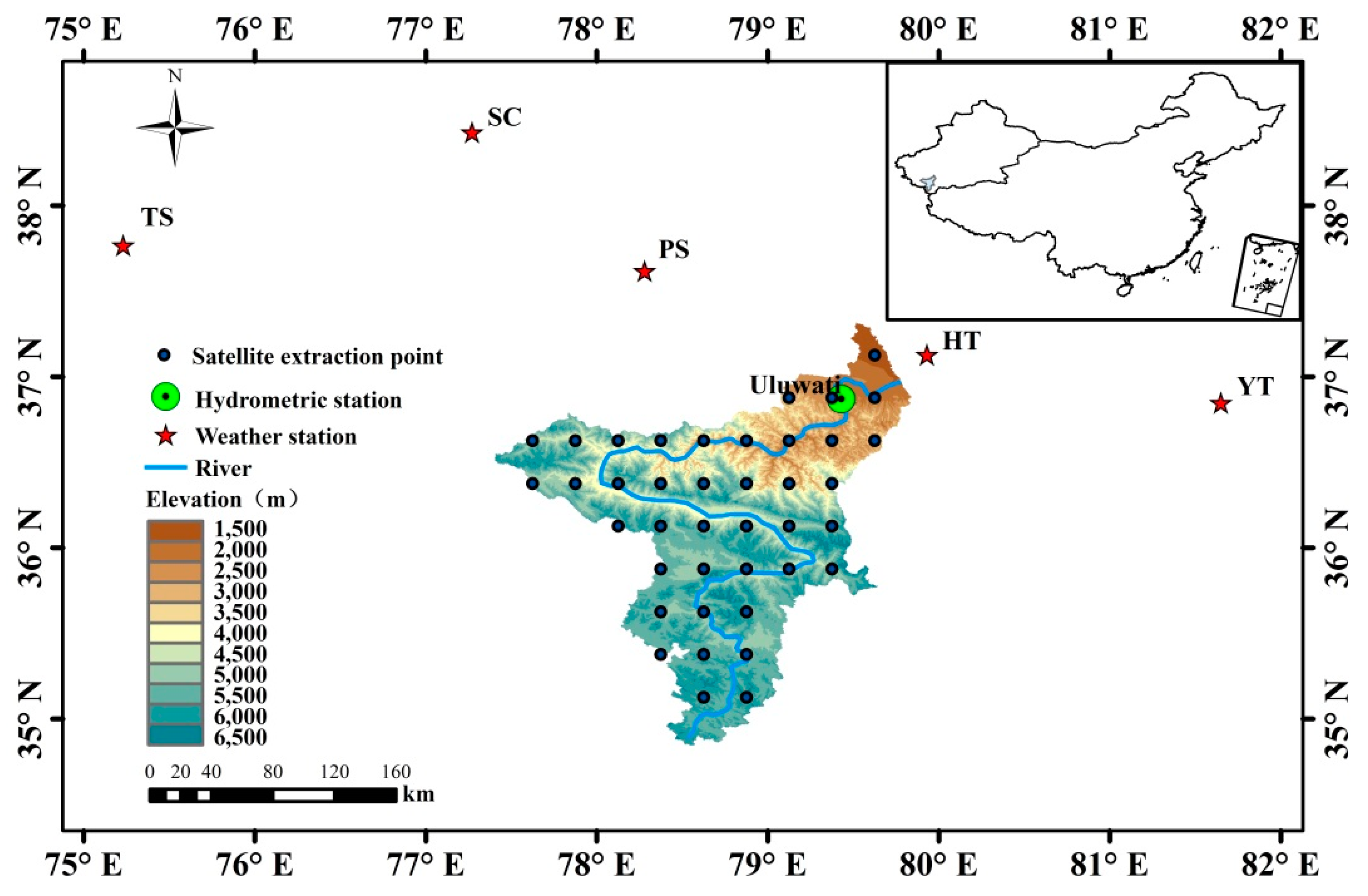
38,
39,
40]. Although the calculation of the physical model is complex, the reliability of the precipitation products can be revealed at the watershed scale using hydrological simulation. As one of the important tributaries of the Hotan River, the hydrological characteristics of the Qaraqash River are vital to the production and life of the downstream residents. Considering that most of the weather stations are located outside the watershed, it may not be possible to obtain accurate judgments just by comparing it with the weather stations. Therefore, to fully clarify the applicability of precipitation products, this study used a combination of statistical indicators and hydrological models to evaluate the applicability of four satellite precipitation datasets, derived from CHIRPS, GSMaP, TRMM 3B42 V7 and SM2RAIN, in the arid mountainous area of northwestern China. The research objective of this study was to screen out the image data that are relatively suitable for the hydrology research of the region lacking data in mountainous areas.
4. Discussion
Under the influence of internal factors such as sensors and algorithms, the accuracy of different satellite precipitation products is significantly different. Under the influence of external factors such as terrain, climate and rainfall intensity, the applicability of the same product in different regions is also different [
58]. According to the research results of this study, the four precipitation products differ significantly in the study area. Among them, GSMaP performed best in the study area. Generally, remote sensing precipitation products have poor accuracy in mountainous areas with complex terrain. However, GSMaP-Gauge and its reanalysis products have been corrected by ground station data, which can effectively enhance their convergence in complex terrain and reduce error fluctuation [
19]. Besides, GPM satellites not only have the advantage of detecting precipitation in tropical regions but also are equipped with dual-frequency precipitation radar (DPR) and GPM microwave imagery (GMI), which greatly improve the detection of solid-state and trace precipitation [
59]. The Qaraqash River basin is located in the arid area of northwest China, where precipitation is scarce and mainly occurs as microprecipitation. Therefore, compared with the other precipitation products, GSMaP has obvious application advantages in the study area.
SM2RAIN is a satellite precipitation product based on soil moisture [
60]. Influenced by ice and snow, the satellite sensor signal is unstable, and the accuracy of precipitation estimation is seriously reduced [
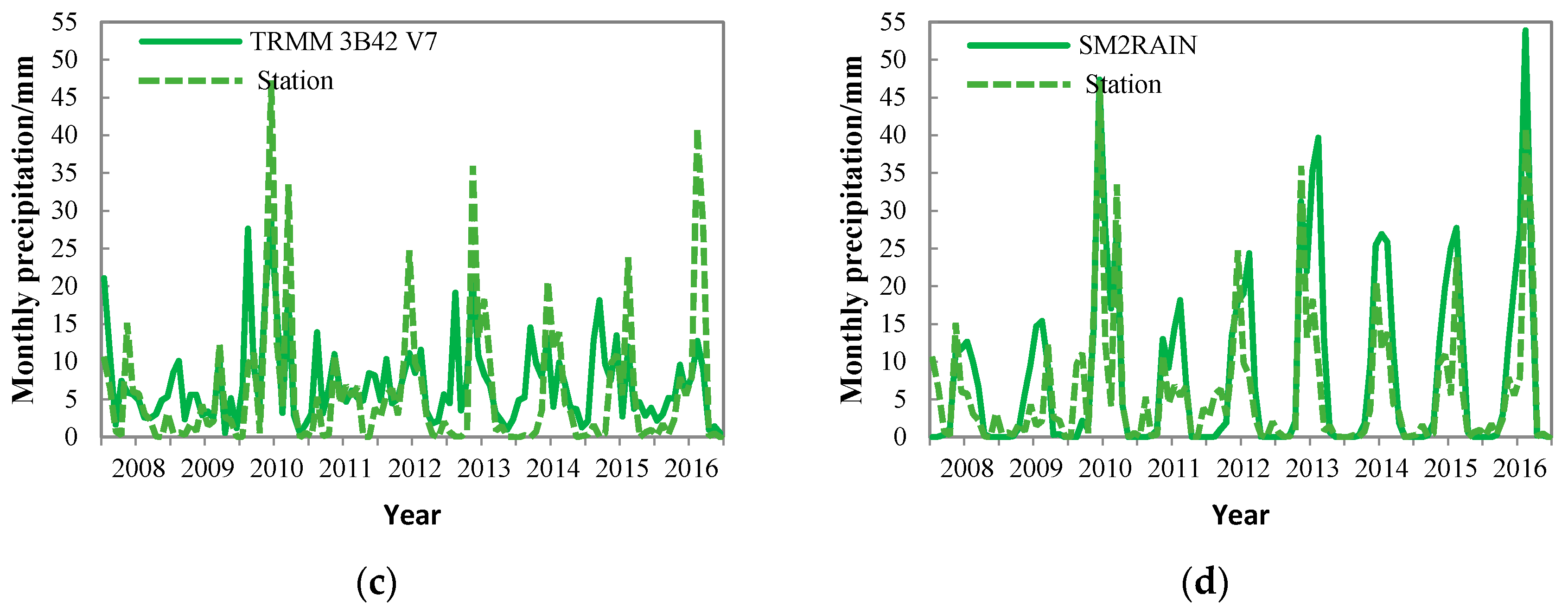
61]. Therefore, SM2RAIN has a poor ability to reproduce the winter precipitation. However, in summer, the influence of snow cover on satellite sensors decreases, thus SM2RAIN has a better detection in summer. Based on the SM2RAIN algorithm, soil moisture is highly sensitive to precipitation, especially in arid areas. The soil variability near the river is larger. Under the influence of multiple factors, the inversion data of SM2RAIN precipitation is relatively high in summer. [
34]. Besides, through time comparison and analysis of runoff simulation results, it can be seen that SM2RAIN still has a certain application potential in the Qaraqash River basin.
TRMM 3B42 V7 and CHIRPS performed poorly in the study area. Huffman pointed out that there is an error of ±8 to ±12% between the TRMM precipitation data and the measured monthly precipitation data, and the phenomenon of underestimation of high value and overestimation of low value is serious [
47,
48]. In this study, TRMM 3B42 V7 shows underestimation in summer and overestimation in winter. The difference in rainfall intensity between winter and summer may be one of the reasons for this phenomenon [
62]. By various comparisons, CHIRPS performed poorly, especially in summer, but by analyzing the precipitation detection rate, CHIRPS showed a high detection rate in the winter half-year. Considering the low performance of SM2RAIN in the winter half-year and the high performance in the summer half-year, perhaps we can integrate the two products (CHIRPS and SM2RAIN) and absorb the advantages of different products to obtain a complete and reliable precipitation product with high space-time continuity and high resolution.
Before inputting satellite data into hydrological model, this study simulated runoff through meteorological station data and calibrated the parameters. Considering that the main purpose of this paper is to discuss the applicability of each precipitation dataset in the study area and select a precipitation product that is most suitable for the study area, to avoid the influence of parameters on the simulation results, the parameters used in the runoff simulation were those after calibrated.
Due to the short time scale of the evaluation in this study, and especially because the daily runoff data are available only for 2008, the evaluation of the hydrological effects of these four products is still not comprehensive, and the applicability of the four products in other periods needs further research. In addition, terrain and climate factors affect the precision of satellite precipitation products to some extent, so the introduction of climate, terrain and other factors can be considered to reduce product error.
5. Conclusions
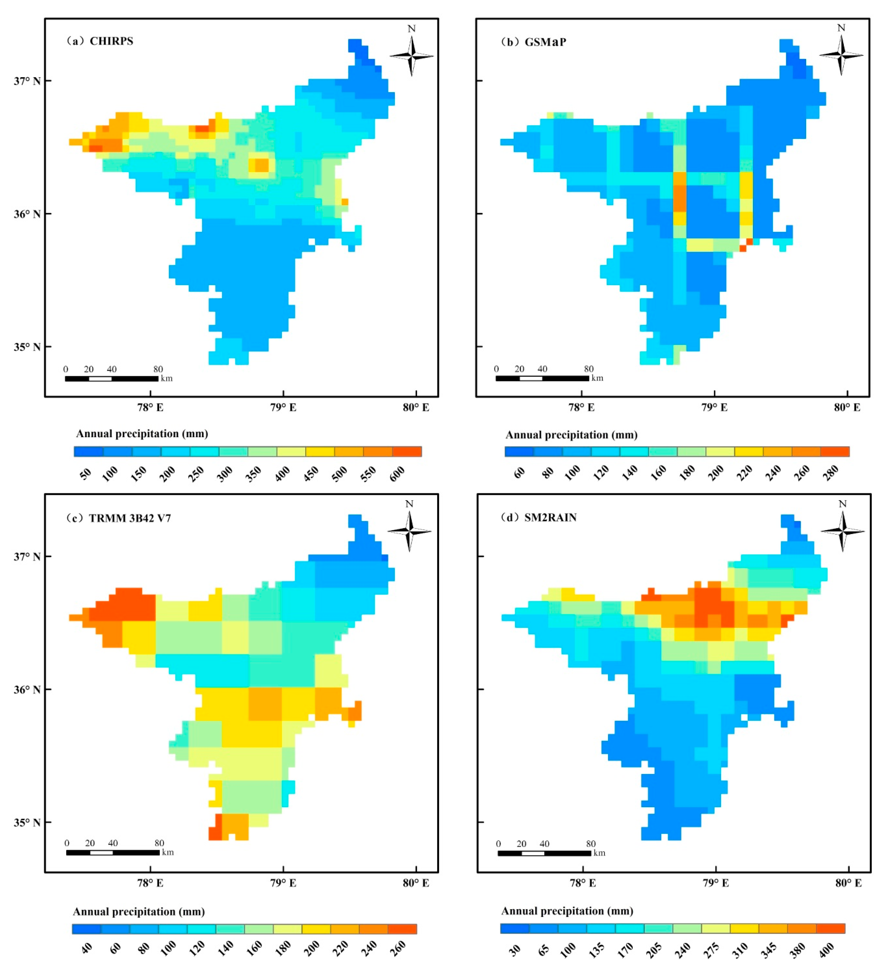
(1) In the Qaraqash River basin, the spatial distribution of four groups of precipitation products is significantly different, and the distribution areas of high precipitation value and low precipitation value have no obvious common characteristics. In the estimation of the total precipitation, the average annual precipitation of GSMaP in the basin is less than the other three sets of data products, but it is close to the average annual precipitation obtained through the interpolation of meteorological stations.
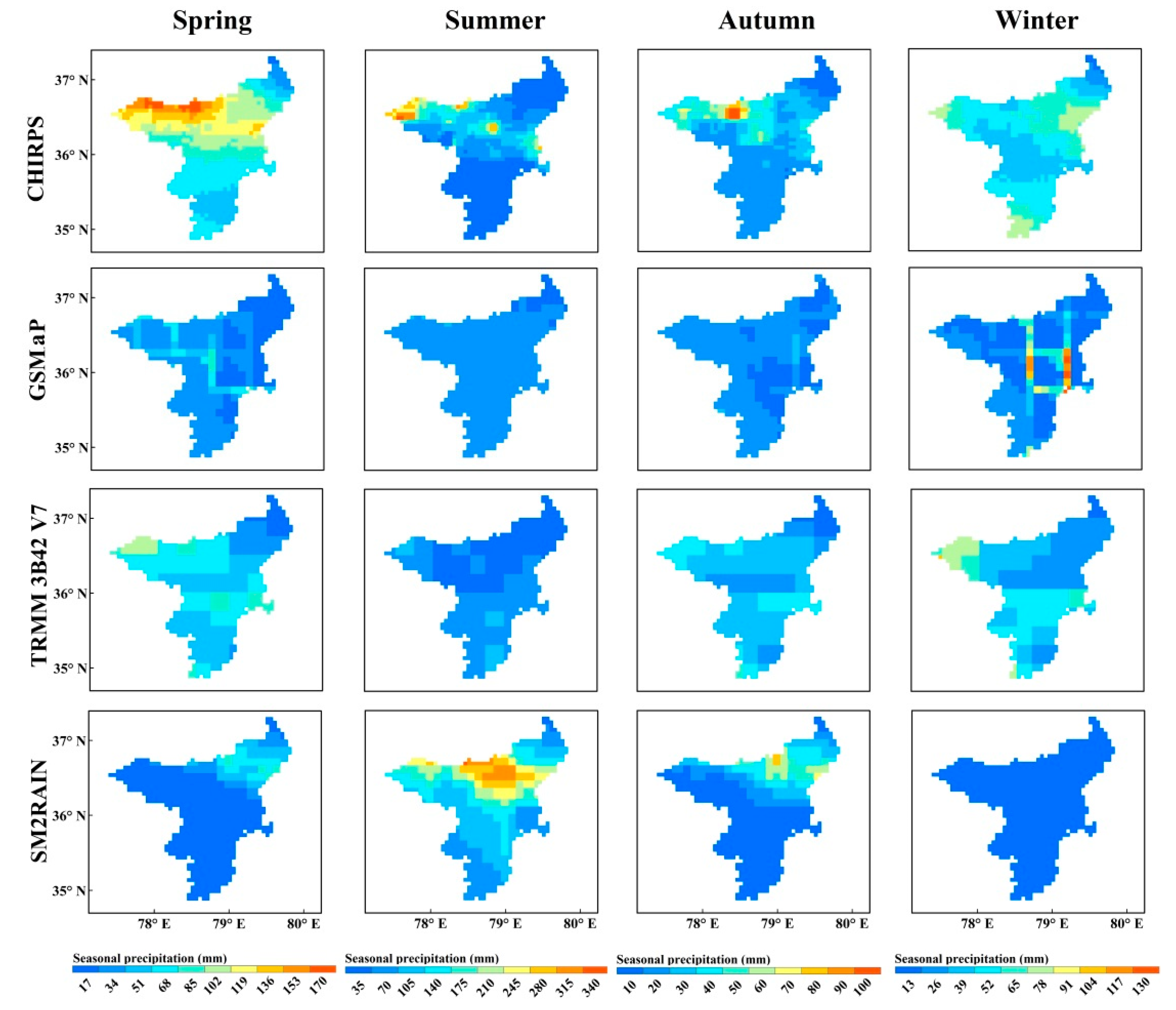
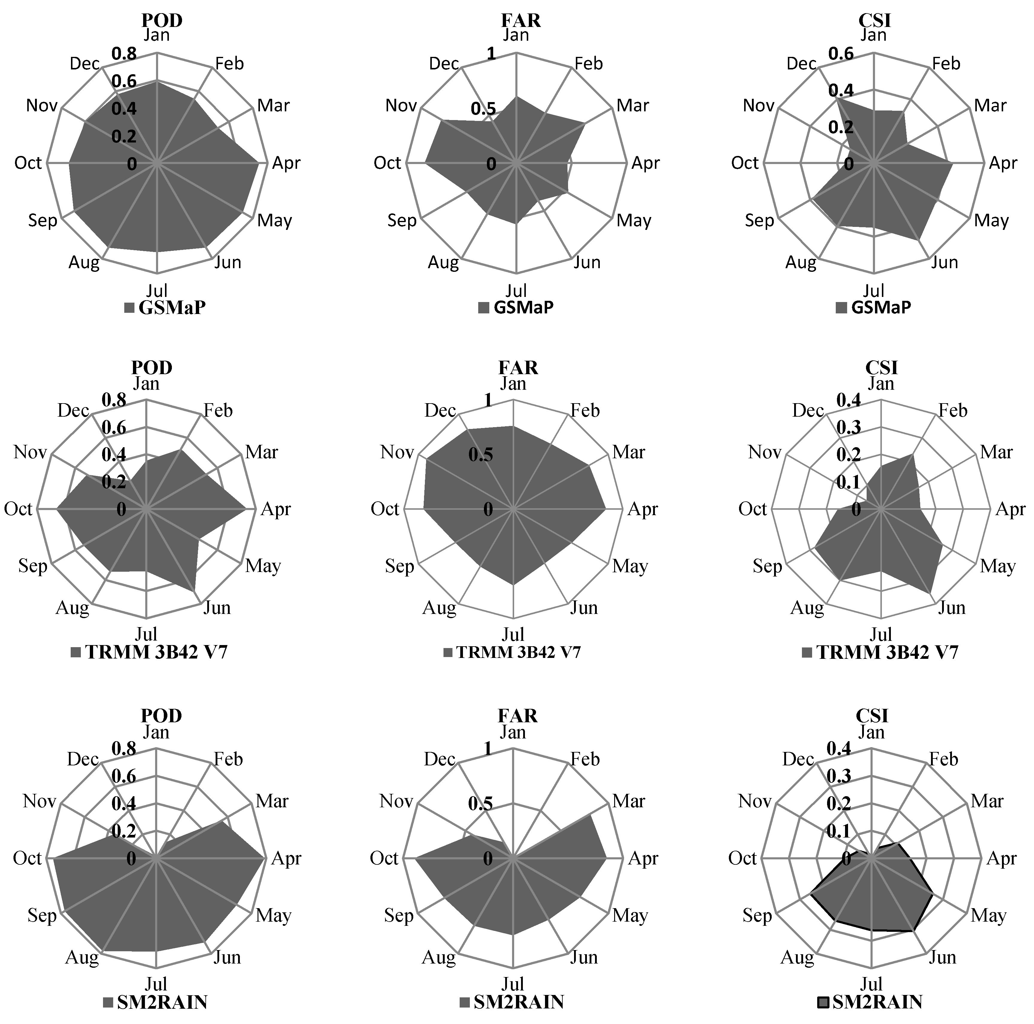
(2) The performance of precipitation products is different on each time period. The consistency between GSMaP and the observed precipitation is generally well. The estimation accuracy of SM2RAIN in summer is significantly better than winter. CHIRPS shows a higher detection rate and high false detection rate in the winter half-year. TRMM 3B42 V7 performs better in summer than in winter. Overall, the estimation accuracy of the four precipitation products in winter is inferior to that in summer.
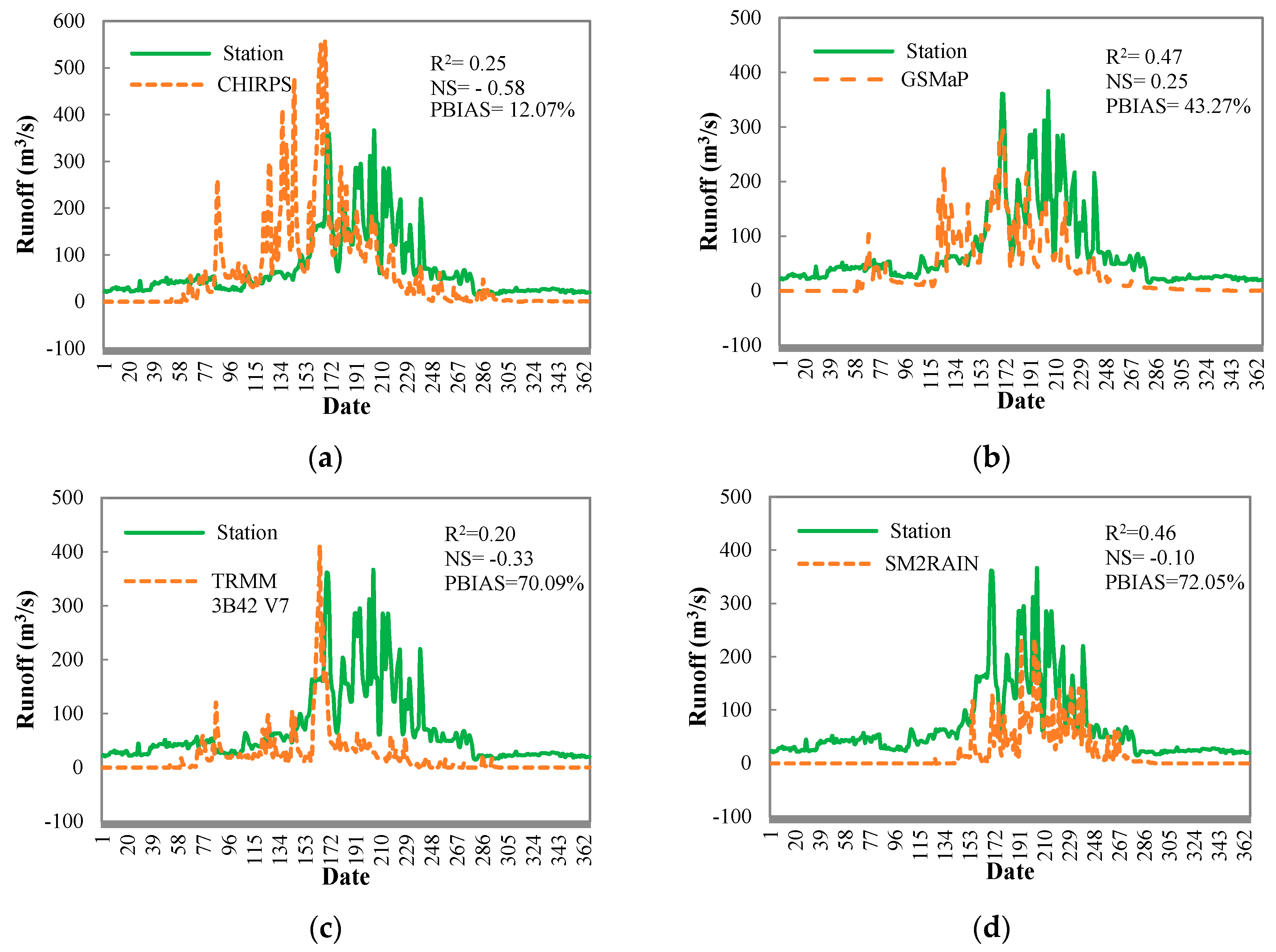
(3) The runoff simulation results based on the SWAT model show that the four products reflect the monthly runoff changes of the Qaraqash River to varying degrees. SM2RAIN and GSMaP have a higher consistency with the actual runoff value in the monthly runoff simulation (R2 > 0.6). At the daily-scale simulation, GSMaP has better application potential than other products (R2 = 0.47, NS > 0). Although SM2RAIN also shows a consistency with the measured runoff, the total simulation error is large.
(4) The scientific findings of this study are as follows: First, the applicability of different remote sensing image data in mountainous areas is different. Second, the image data with certain application potential in mountainous areas were determined. The contribution of this paper is to provide a scientific reference for constructing the optimal combination of multisource image data suitable for mountainous areas.


