Article

Applications of the Google Earth Engine and Phenology-Based Threshold Classification Method for Mapping Forest Cover and Carbon Stock Changes in Siem Reap Province, Cambodia

by
Manjunatha Venkatappa
1,2,3,*,
Nophea Sasaki
4,
Sutee Anantsuksomsri
1,2 and
Benjamin Smith
5,6
1
Regional Urban and Built Environmental Analytics, Faculty of Architecture, Chulalongkorn University, 254 Phayathai Road, Pathumwan, Bangkok 10330, Thailand
2
Department of Urban and Regional Planning, Faculty of Architecture, Chulalongkorn University, 254 Phayathai Road, Pathumwan, Bangkok 10330, Thailand
3
LEET intelligence Co., Ltd., Perfect Park, Suan Prikthai, Muang Pathum Thani, Pathum Thani 12000, Thailand
4
Natural Resources Management, School of Environment, Resources and Development, Asian Institute of Technology. P.O. Box 4, Khlong Luang, Pathumthani 12120, Thailand
5
Hawkesbury Institute for the Environment, Western Sydney University, Bourke St, Richmond, Sydney, NSW 2753, Australia
6
Department of Physical Geography and Ecosystem Science, Sölvegatan 12, Lund University, S-223 62 Lund, Sweden
*
Author to whom correspondence should be addressed.
Remote Sens. 2020, 12(18), 3110; https://doi.org/10.3390/rs12183110
Submission received: 25 July 2020 / Revised: 4 September 2020 / Accepted: 15 September 2020 / Published: 22 September 2020
(This article belongs to the Special Issue Forest Canopy Disturbance Detection Using Satellite Remote Sensing)

Abstract

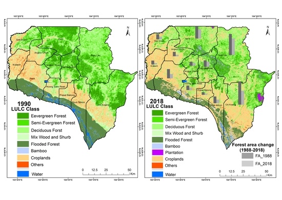
Digital and scalable technologies are increasingly important for rapid and large-scale assessment and monitoring of land cover change. Until recently, little research has existed on how these technologies can be specifically applied to the monitoring of Reducing Emissions from Deforestation and Forest Degradation (REDD+) activities. Using the Google Earth Engine (GEE) cloud computing platform, we applied the recently developed phenology-based threshold classification method (PBTC) for detecting and mapping forest cover and carbon stock changes in Siem Reap province, Cambodia, between 1990 and 2018. The obtained PBTC maps were validated using Google Earth high resolution historical imagery and reference land cover maps by creating 3771 systematic 5 × 5 km spatial accuracy points. The overall cumulative accuracy of this study was 92.1% and its cumulative Kappa was 0.9, which are sufficiently high to apply the PBTC method to detect forest land cover change. Accordingly, we estimated the carbon stock changes over a 28-year period in accordance with the Good Practice Guidelines of the Intergovernmental Panel on Climate Change. We found that 322,694 ha of forest cover was lost in Siem Reap, representing an annual deforestation rate of 1.3% between 1990 and 2018. This loss of forest cover was responsible for carbon emissions of 143,729,440 MgCO2 over the same period. If REDD+ activities are implemented during the implementation period of the Paris Climate Agreement between 2020 and 2030, about 8,256,746 MgCO2 of carbon emissions could be reduced, equivalent to about USD 6-115 million annually depending on chosen carbon prices. Our case study demonstrates that the GEE and PBTC method can be used to detect and monitor forest cover change and carbon stock changes in the tropics with high accuracy.
Keywords: Landsat-8; Landsat TM; Google Earth Engine; tropical forestry; forest carbon stocks; emission reductions; REDD+; PBTC Landsat-8; Landsat TM; Google Earth Engine; tropical forestry; forest carbon stocks; emission reductions; REDD+; PBTC
Graphical Abstract