Article

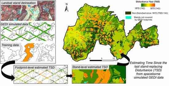
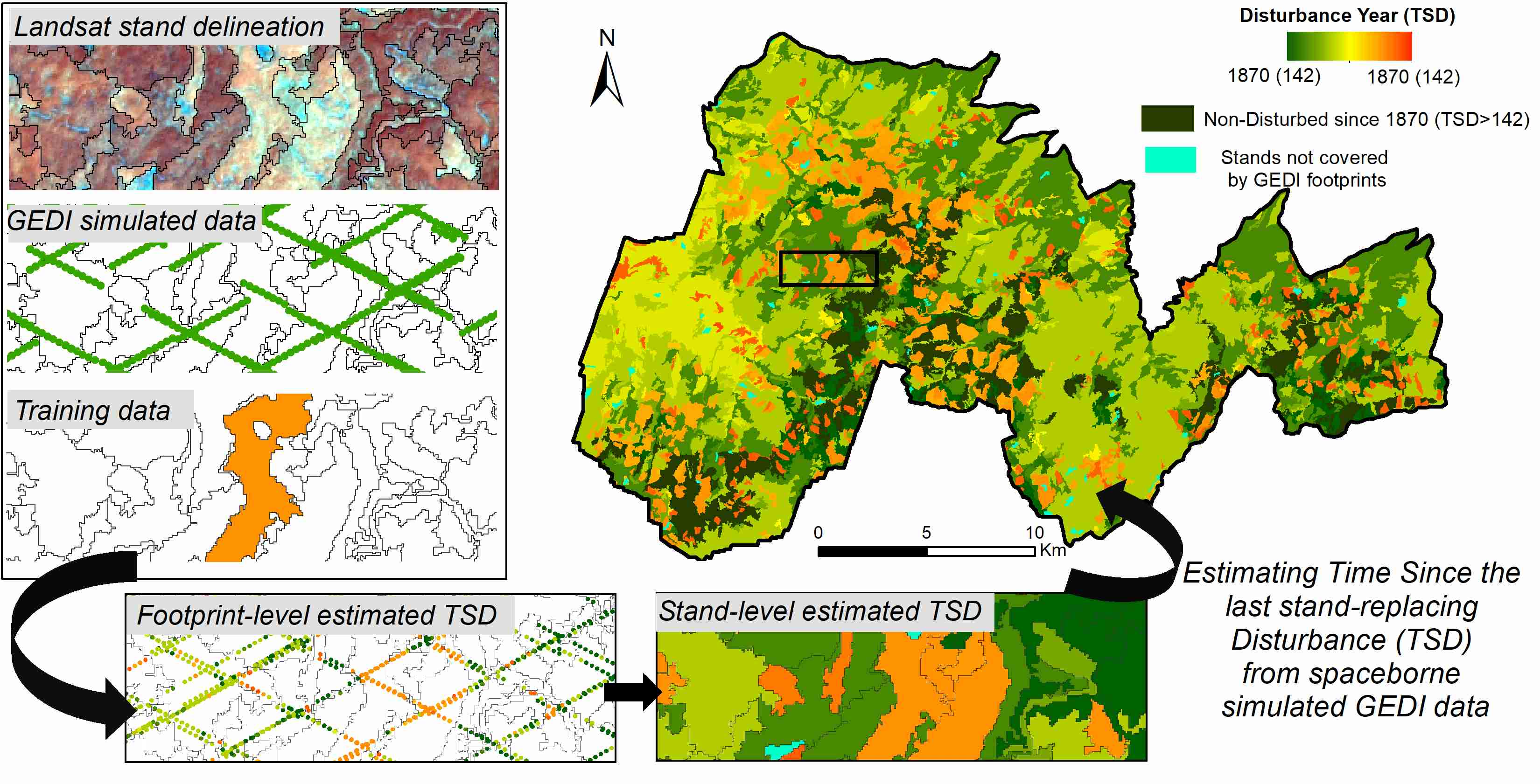
Estimating Time Since the Last Stand-Replacing Disturbance (TSD) from Spaceborne Simulated GEDI Data: A Feasibility Study

1
Department of Forest, Rangeland and Fire Sciences, College of Natural Resources, University of Idaho, 875 Perimeter Drive, Moscow, ID 83844, USA
2
Department of Agriculture, Forest Service, U.S., Rocky Mountain Research Station, Forestry Sciences Laboratory, 1221 South Main St., Moscow, ID 83843, USA
3
Department of Geographical Sciences, University of Maryland, College Park, MD 20742, USA
4
School of Geosciences, University of Edinburgh, Edinburgh EH8 9XP, UK
*
Author to whom correspondence should be addressed.
Remote Sens. 2020, 12(21), 3506; https://doi.org/10.3390/rs12213506
Submission received: 10 September 2020 / Revised: 22 October 2020 / Accepted: 22 October 2020 / Published: 25 October 2020
(This article belongs to the Section Forest Remote Sensing)

Abstract

Stand-level maps of past forest disturbances (expressed as time since disturbance, TSD) are needed to model forest ecosystem processes, but the conventional approaches based on remotely sensed satellite data can only extend as far back as the first available satellite observations. Stand-level analysis of airborne LiDAR data has been demonstrated to accurately estimate long-term TSD (~100 years), but large-scale coverage of airborne LiDAR remains costly. NASA’s spaceborne LiDAR Global Ecosystem Dynamics Investigation (GEDI) instrument, launched in December 2018, is providing billions of measurements of tropical and temperate forest canopies around the globe. GEDI is a spatial sampling instrument and, as such, does not provide wall-to-wall data. GEDI’s lasers illuminate ground footprints, which are separated by ~600 m across-track and ~60 m along-track, so new approaches are needed to generate wall-to-wall maps from the discrete measurements. In this paper, we studied the feasibility of a data fusion approach between GEDI and Landsat for wall-to-wall mapping of TSD. We tested the methodology on a ~52,500-ha area located in central Idaho (USA), where an extensive record of stand-replacing disturbances is available, starting in 1870. GEDI data were simulated over the nominal two-year planned mission lifetime from airborne LiDAR data and used for TSD estimation using a random forest (RF) classifier. Image segmentation was performed on Landsat-8 data, obtaining image-objects representing forest stands needed for the spatial extrapolation of estimated TSD from the discrete GEDI locations. We quantified the influence of (1) the forest stand map delineation, (2) the sample size of the training dataset, and (3) the number of GEDI footprints per stand on the accuracy of estimated TSD. The results show that GEDI-Landsat data fusion would allow for TSD estimation in stands covering ~95% of the study area, having the potential to reconstruct the long-term disturbance history of temperate even-aged forests with accuracy (median root mean square deviation = 22.14 years, median BIAS = 1.70 years, 60.13% of stands classified within 10 years of the reference disturbance date) comparable to the results obtained in the same study area with airborne LiDAR.
Keywords: time since disturbance (TSD); GEDI; spaceborne LiDAR; Landsat; GEOBIA time since disturbance (TSD); GEDI; spaceborne LiDAR; Landsat; GEOBIA
Graphical Abstract

