Article

Precipitation Enhancement Experiments in Catchment Areas of Dams: Evaluation of Water Resource Augmentation and Economic Benefits

Convergence Meteorological Research Department, National Institute of Meteorological Sciences, Seogwipo, Jeju 63568, Korea
*
Author to whom correspondence should be addressed.
Remote Sens. 2020, 12(22), 3730; https://doi.org/10.3390/rs12223730
Submission received: 7 October 2020 / Revised: 28 October 2020 / Accepted: 11 November 2020 / Published: 13 November 2020

Abstract

:
This study calculated the augmentation of water resources that can be achieved through precipitation enhancement and the ensuing economic benefits by conducting precipitation enhancement experiments using atmospheric aircraft in the catchment areas of 21 multipurpose dams in Korea. The maximum number of precipitation enhancement experiments to be carried out was estimated based on the frequency of occurrence of seedable clouds near each dam, using geostationary satellite data. The maximum quantity of water that can be obtained was calculated considering the mean precipitation enhancement and probability of success, as determined from the results of experiments conducted in South Korea during 2018–2019. The effective area of seeding was assumed 300 km2. In addition, the amount of hydroelectric power generation possible was determined from the quantity of water thus calculated. In conclusion, it was established that an approximate increase of 12.89 million m3 (90% confidence interval: 7.83–17.95 million m3) of water, and 4.79 (2.91–6.68) million kWh of electric power generation will be possible through approximately 96 precipitation enhancement operations in a year at the catchment area of Seomjin River (SJ) dam which has a high frequency of occurrence of seedable clouds, a large drainage area, and a high net head. An economic benefit of approximately 1.01 (0.61–1.40) million USD can be anticipated, the benefit/cost ratio being 1.46 (0.89–2.04).

Graphical Abstract

1. Introduction

Water on Earth is comprised of water vapor, liquid water, and solid ice, which circulate the atmosphere, land, and ocean through mutual and continuous phase changes [1]. The ocean covers approximately 70% of the Earth’s surface, but only approximately 9% of the water vapor from evaporation from the surface of the ocean moves inland [2,3]. Approximately 97% of the world’s water resources is saline water and the rest is freshwater, but water resources that we can actually use (groundwater, lakes, streams, etc.) account for only 0.3% (11.1 million km3) of this freshwater [4,5,6]. Humanity has used this freshwater for drinking and other direct uses, as well as in agriculture, industries, etc., but the amount of water used is constantly increasing with increases in the population [6,7,8]. The United Nations (UN) reported that the world’s population has doubled over the past century, whereas water use has increased six-fold [9]. The Organization for Economic Cooperation and Development (OECD) monitors and forecasts water shortages due to population increase; it provides the current water stress index of each country as well as the predicted water stress index for the future [10,11,12]. Countries use various methods to secure their water resources.
In the case of countries such as South Korea that consist of mostly mountainous regions and have topographic characteristics that are advantageous for dam construction, the most effective way to secure water resources is to construct dams. However, construction of a dam requires thousands of millions to a billion USD as the initial construction costs and also causes social and environmental issues, such as 10–20 years of the construction period, geographical and environmental changes, and destruction of the ecosystem in areas submerged due to the construction of the dam [13,14]. Ways to secure water resources while minimizing these issues include wastewater reuse, seawater desalination, use of groundwater, rainwater harvesting, riverbank filtrate, and deep-sea water use, as well as precipitation enhancement [14]. However, improving the quality of water resources through purification and storage incurs higher initial investment and maintenance costs compared to the amount of water thus obtained [13,15]. On the other hand, precipitation enhancement can help secure water resources at a relatively low cost while also minimizing environmental problems [16,17,18,19,20]. Water resources generated from precipitation enhancement through cloud seeding may bring 2–3 times greater economic benefits compared to investment costs, and many countries are encouraging this through various field campaigns and funds by presenting the effects of precipitation enhancement as well as the ensuing economic benefits [18,21,22,23,24].
The annual precipitation in South Korea is approximately 1300 mm on mean in a normal year, which is approximately 1.6 times the global mean, but the precipitation per capita in South Korea is 2546 m3/year, which is about 1/6th the global mean [14,25]. That is, it means that the population density of South Korea is high. Moreover, approximately 70% of the annual precipitation in South Korea occurs during the rainy season [26,27,28]. Therefore, there are water shortages in the dry season, causing difficulties in securing water. If this situation is prolonged, it leads to drought that causes not only water scarcity but also severe economic loss in terms of damage to crops and decreased industrial productivity [27,29,30,31]. South Korea is already a water-stressed country, as the available water resources per capita (excluding loss by evapotranspiration, etc.) are only 1453 m3 (129th among 153 countries) which is expected to decrease to 1100 m3 in 2050 based on the demographic prospects for the country [6,10,32]. Therefore, South Korea has been conducting precipitation enhancement experiments using the Korea Meteorological Administration/National Institute of Meteorological Sciences (KMA/NIMS) Atmospheric Research Aircraft (NARA) since 2018, with an aim to enhance water resources [33,34,35].
South Korea’s precipitation enhancement experiments have a wide range of purposes, such as precipitation enhancement, prevention of forest fires, reduction of particulate matter, and fog dispersion. Recently, there have been experiments aimed at securing water resources in reservoirs [35]. South Korea depends on dams for 56% of national water use, followed by 33% from stream water, and 11% from groundwater [36]. There are 17,491 dams in South Korea as of 2020, including agricultural reservoirs. The water storage capacity of 21 dams classified as multipurpose dams, considering their effective storage capacity, accounts for approximately 66.8% of the water use from all dams nationally [14,36]. Energy production from hydroelectric power is approximately 1.2% of the total annual energy production, of which 50% is produced by dams [14]. This study calculated the quantity of water and evaluated economic benefits that accrue in a year from each dam by conducting cloud seeding experiments on seedable clouds detected by geostationary satellite in dam catchments, as a method to secure water resources in South Korea. In other words, economic evaluation was performed on 21 multipurpose dams with sufficiently large water storage capacity. In addition to storing water, these dams generate hydroelectricity while distributing the stored water, thereby providing greater economic benefits than dams used for storage or hydroelectric power generation alone. Information on 21 multipurpose dams is provided in Section 2; the quantity of water that can be obtained through precipitation enhancement, resulting in an increase in hydroelectricity generation, and economic benefit calculation methods are presented in Section 3.

2. Data and Research Methods
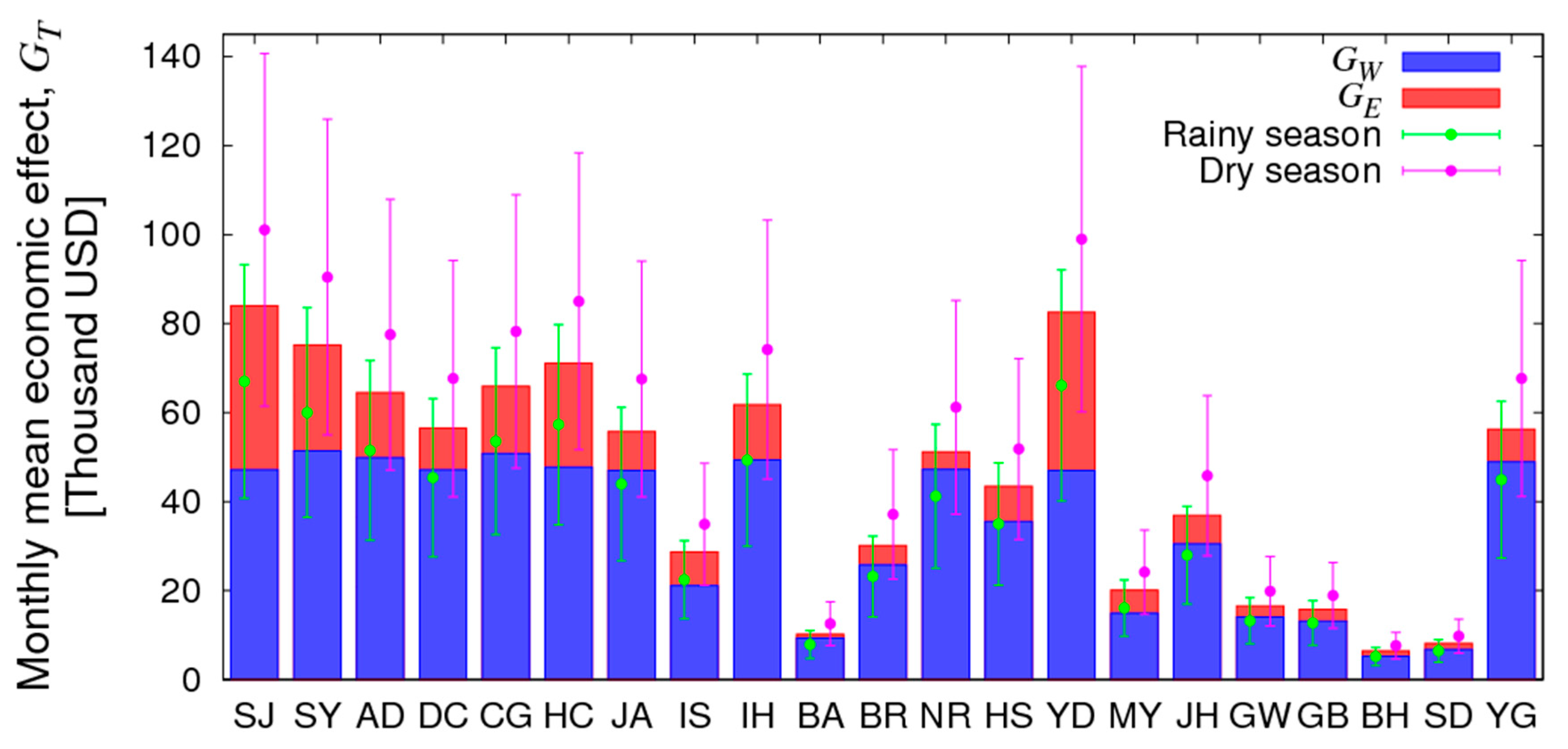
21 multipurpose dams constructed and in use in the Korean Peninsula until now, are shown in Figure 1, and the characteristics of each dam are summarized in Table 1 (www.wamis.go.kr, www.kwater.or.kr). Most dams are located downstream of the river, and store water. The dam with the largest drainage area is Chungju (CJ) dam (6648 km2), and the dam with the largest water storage capacity is the Soyang River (SY) dam (2900 million m3). The dam with the smallest drainage area and water storage capacity is the Bohyeon Mountain (BH) dam (33 km2 and 22 million m3, respectively), indicating that there are gaps among the dams with respect to drainage area and storage capacity. Each dam supplies water and electric power to surrounding areas. To analyze the precipitation enhancement in these catchments brought about by the cloud seeding experiment, and the corresponding economic effects, this study first analyzed the frequency of occurrence of clouds around the Korean Peninsula, and clouds that are suitable for the seeding experiment (seedable clouds). Cloud output data of the Communication, Ocean, and Meteorological Satellite (COMS) were used. The COMS is located at 0°N latitude and 128.2°E longitude and observes the Korean Peninsula with a spatial resolution of 4 km × 4 km at 15-min intervals.
Unlike polar satellites or ground-based observation instruments (e.g., radar), geostationary satellites can continuously observe an extensive range of clouds occurring around the Korean Peninsula [37]. In the case of a polar satellite, the spatial resolution is higher than that of a geostationary satellite, but the same area can be observed only approximately twice a day [38,39]. Most radars located in South Korea are S-band and C-band rain radars, which are not suitable for cloud detection [40,41]. Therefore, geostationary satellites are most suitable for detecting and analyzing the characteristics of clouds occurring around the Korean Peninsula [35,42]. Data used in the analysis include cloud fraction, cloud top height, cloud top temperature, cloud phase, and rainfall intensity, using the hourly data from 0900 and 1800 LST observed from January 2017 to December 2019.
In precipitation enhancement experiments using the atmospheric aircraft, the seeding material serves as an artificial cloud seed, which might help to develop the cloud, while causing rainfall (snowfall) [43,44]. Generally, AgI is seeded in the upper layer of cold clouds (ice phase or cloud top temperature less than −5 °C), and CaCl2 is seeded in the lower layer of warm clouds (water phase or cloud top temperature −5 °C or higher) [45,46,47]. Therefore, seedable clouds can be detected using cloud characteristics (cloud cover, cloud height, cloud top temperature, cloud phase, etc.) and information on the presence or absence of precipitation [48]. The proportion of seedable clouds in satellite data is defined as the case in which the cloud fraction exceeds 80%, cloud-top height is within 1–4 km, cloud phase is water (or cloud top temperature −5 °C or higher with mixed-phase) or ice (or cloud top temperature less than −5 °C with mixed-phase), and rainfall intensity is less than 5 mm/h, using the algorithm presented in Kim et al. [35]. This algorithm detected seedable clouds considering the actual height at which precipitation enhancement experiments were conducted in South Korea, as well as weather conditions such as weak natural precipitation or the absence of precipitation. The mean frequency of occurrence of seedable clouds within a 200 km radius of the dams was also calculated [35]. This is the maximum distance presumed to cause a seeding effect in the target area through the precipitation enhancement experiment [49,50,51]. The three years mean frequency of occurrence of seedable clouds for the dam was calculated by the occurrence frequency of seedable clouds of the dam, and it was presumed that precipitation enhancement experiments can be conducted as frequently as the mean occurrence frequency. Considering this fact, the maximum enhancement of water resources ( W , m3) and hydroelectricity generation ( E , kWh), as well as economic benefits that can be achieved from conducting the precipitation enhancement operation with each dam as the target area, can be calculated as shown in Equations (1)–(6) [52,53,54,55].
W = R × P × N × A
N = ( S C × days × 10 h ) / 3 h
E = W × H × F
G W = W × 0.044   USD / m 3
G E = E × 0.092   USD / kWh
G T = G W + G E
R and P in Equation (1) refer to the mean precipitation enhancement 0.67 mm, and the probability of success 66.67% of the precipitation enhancement experiments conducted using atmospheric aircraft in 2018 and 2019, as summarized in Table 2 [34,56,57,58,59]. Here, it is assumed that there may have been a maximum of 20% enhancement in precipitation when the effects of precipitation enhancement are combined with natural precipitation, in calculating R [18,22,51,60]. A slight precipitation enhancement (less than 0.1 mm) was detected in the case of January 25, 2019, was excluded in the calculation of   R and P . Precipitation enhancement experiments have been continuously conducted in various countries, as they have been recognized for their effectiveness [16,20,47,60,61,62]. In general, the probability of success of such experiments is around 60–70%, while in the USA, the probability of success was up to 85% [63,64]. The cloud seeding effect in precipitation enhancement can largely differ depending on the experimental situation, weather conditions, and geographic characteristics, but usually, more than several mm can be expected [50,65,66]. The probability of success of the experiment presented in this study is similar to that in other countries, but the mean precipitation enhancement is not yet comparable to the advanced technology. In addition, the mean precipitation enhancement was 0.67 mm, but the confidence interval of the 90% confidence level was 0.41 to 0.94 mm, which is relatively uncertain. Therefore, a mean cloud seeding effect of 0.44 mm ( R × P ) per experiment can be expected, but there may be a difference of ±0.17 mm at the 90% confidence level.
The maximum number of experiments ( N ) was defined by converting the monthly seedable-cloud occurrence frequency ( S C ) for each dam to hours when the seedable clouds will be present, and dividing it into 3-h intervals, 3 h being the maximum time required for each experiment [24,58,59]. The time required for the experiment considered the time for installing flares, travel time to the seeding area and back (approximately 2 h), and time for seeding at the target area (approximately 1 h). The net cost that can incur per precipitation enhancement experiment is approximately 7.14 thousand USD (1 USD = 1200 KRW), including the cost of operating an atmospheric aircraft and the cost of the seeding material, which was calculated as the cost for the experiment in the economic evaluation [20,62]. Flares are CaCl2/AgI burn-in-place flares of Ice Crystal Engineering (ICE), which consumed in each experiment was approximately 17, and each flare took 3–4 min of burning time.
The effective area (A) of ground for precipitation enhancement by the seeding effect is the drainage area of each dam as shown in Table 1, and the effective area is set at a maximum of 300 km2 if the drainage area exceeds 300 km2. This effective area may be smaller or larger depending on the experimental and weather conditions. This study set the mean effective area as 300 km2 based on previous studies [17,54,65,67,68], and assumed that precipitation enhancement would occur within this area. The effective area of most seeding experiments is determined by measuring precipitation enhancement, distinguishing the area in which the seeding material spread, as well as the seeding and non-seeding areas, based on model simulation or radar echo [69,70,71]. However, unless the ground rain gauges are densely installed, it is difficult to verify whether precipitation is enhanced by the seeding effect. This is because precipitation enhancement experiments are conducted targeting rural areas, farms, and forests where rain gauges are not densely installed in most cases [20,56,57,58,59].
Hydroelectricity generation E (W) can be calculated using the net head H (m), and facility efficiency F (0.00245 kWh/m3/m) [72,73]. That is, the hydroelectric power generation efficiency ( H × F ) varies according to the net head for each dam. The selling price of water is 0.044 USD/m3, which is determined by the Korea Water Resources Corporation (KWRC, www.water.or.kr), and increases by approximately 5% every 4–5 years. The selling price of electricity per kWh in Equation (5) is decided every year by the Korea Electric Power Corporation (KEPCO, www.kepco.co.kr), and the mean for the past 5 years was calculated as 0.092 USD/kWh; the selling price of electricity showed a change of less than 2% every year. G W and G E are the economic benefits generated by selling water and electricity, respectively. G T refers to the combined increase in G W and G E arising from the economic benefits due to enhanced precipitation.

3. Results

The frequency of occurrence of clouds and seedable clouds around 21 multipurpose dams, is shown in Figure 2a. The cloud occurrence frequency refers to conditions where the cloud fraction is 80% or higher regardless of cloud top height. Clouds that occurred in each dam area showed high variability depending on the season, with the highest occurrence frequency of 54.91% on mean in July and the lowest occurrence frequency of 25.69% on mean in January [35,74]. In other words, the cloud occurrence frequency was high in the rainy season (April–September) with a mean of 46.43%, and low in the dry season (October–March), with a mean of 32.02%. In contrast, the occurrence frequency of seedable clouds was low in the rainy season, with a mean of 6.50%, and high in the dry season, with a mean of 9.98%. East Asian regions, including South Korea, exhibit many clouds in the rainy season due to the influence of monsoons as well as the high frequency of occurrence of high and middle clouds, and frequent precipitation [28,29,75,76]. Therefore, the frequency of the occurrence of seedable clouds is relatively low during the rainy season [35]. In the dry season, the frequency of occurrence of low clouds is high, and there is little precipitation, and thus approximately 31% of clouds that occurred around the dam were identified as seedable clouds [77,78,79,80]. In the rainy season, only 14% were identified as seedable clouds.
Figure 2b shows the monthly occurrence frequency of seedable clouds in each dam area (shown in Figure 2a). A mean of 6.51 experiments could be conducted in the rainy season with concentrated precipitation, and a mean of 9.86 experiments in the dry season. There was not much difference in the number of experiments for each dam in general (0.87 experiments on mean) in the rainy season except in July; there was a huge gap in July in terms of the mean number of experiments and the number of experiments in the 4th quartile. A total of 1.28 times more experiments may be conducted on mean in areas around dams (SY, AD, CG, IH, HS, GW, BH, SD, and YG) located near the Taebaek Mountains (east of the Korean Peninsula, approximately 1 km above sea level) compared to the mean number of experiments (6.57 times) in other areas, due to the occurrence of orographic clouds resulting from the topographic effect [35,81,82]. Contrary to the rainy season, January shows a huge gap in the mean number of experiments and the number of experiments in the 4th quartile; in areas near dams (JA, IS, BA, BR, and JH) located near the coast (southwest of the Korean Peninsula), with cumulus cloud bands generated in the ocean; 1.64 times more experiments on mean can be carried out compared to the mean number of experiments (9.72) in other areas [35,83,84]. For dams located inland (SJ, DC, HC, NR, YD, MY, and GB), the mean number of experiments for each dam was similar every month. The number of experiments was determined from the frequency of occurrence of seedable clouds defined in this study. However, only the highest-level clouds in the atmosphere may be detected using geostationary satellite data, resulting in failure to detect low and middle clouds that meet the experimental conditions, among the possible cases. Therefore, the maximum number of experiments presented in this study may be similar to or higher than the number of ideal conditions for seeding that were actually present [35,79,85,86].
If the number of experiments that can be conducted for each dam, as per Figure 2, are carried out, the mean quantity of water that can be obtained every month, and the electricity that can be generated through hydroelectric power generation are as shown in Figure 3. The distribution in Figure 3a corresponds to the number of experiments, but the quantity of water that can be secured depending on the drainage area of each dam showed a minimum 8-fold to maximum 12-fold difference or more. The quantity of water that can be obtained was highest (1.17 million m3 on mean) for SY dam with a large drainage area, and smallest (0.12 million m3 on mean) for BH dam with the smallest drainage area (32.6 km2), even though it had the 8th highest number of possible precipitation enhancement experiments. A monthly mean of 0.77 million m3 of water can be obtained from all dams, and a monthly mean of 0.93 million m3 of water can be obtained in the dry season. In particular, SY dam can accumulate the highest quantity of water with a mean of 0.93 million m3 in the rainy season and 1.41 million m3 in the dry season, and by completing the possible number of precipitation enhancement operations (approximately 104 times), it would be possible to obtain 14.04 million m3 of water every year. This figure can differ by ±39%, from 8.53 to 19.55 million m3 at a 90% confidence level.
In fact, precipitation is concentrated in the rainy season, and thus it may be possible to supply enough water without precipitation enhancement through cloud seeding. However, there may be a water shortage in April–May and August–September if the rainy season begins late or ends early. Moreover, a certain amount of water is discharged from dams to lower the water levels in the reservoirs before this period, to prepare for the possibility of the overflow of dams during the rainy season and due to typhoons [81]. Therefore, precipitation enhancement experiments may be necessary even in the rainy season, depending on the circumstances. In addition, even during the dry season, floodgates must be controlled to maintain drought storage, prevent eutrophication and inactive storage, maintain the ecology of the surrounding environment, and manage the river basins [87,88,89,90,91]. In other words, it is necessary to regularly discharge a certain amount of water and circulate it instead of always keeping water stored in the reservoir [92]. Thus, it is very difficult to manage water resources by operating dams; securing water resources needs to be carried out at all times as water is continuously used.
Figure 3b shows the maximum amount of electricity that can be obtained from hydroelectric power generation with the water obtained through precipitation enhancement. Unlike Figure 3a, there is a huge gap between the electricity generation of the 4th quartile and the monthly mean. The quantity of water is affected by the catchment area of dams (effective area of the seeding effect), and hydroelectricity generation is affected greatly by the quantity of water obtained as well as the net head. Therefore, the SY dam can secure the highest amount of water (monthly mean of 1.17 million m3) but has a small net head (90 m). Thus, hydroelectricity generation (monthly mean of 0.26 million kWh) is 0.65 times lesser than for the SJ dam with a net head of 151.7 m. In fact, the SJ dam can generate at least three times more hydroelectricity than the monthly mean of all the other dams put together. This is 39.31 times greater than that of the BA dam with the least amount of hydroelectricity generation. Therefore, by conducting precipitation enhancement operations targeting dams with high seedable-cloud occurrence frequency, large drainage area, and high net head, high economic benefits can be anticipated through hydroelectric power generation, in addition to securing water resources.
Figure 4 shows the economic benefit from electricity produced by hydroelectric power generation, and the mean quantity of water obtained monthly in the rainy season and dry season in each dam of Figure 3. Out of 21 multipurpose dams, the SJ dam exhibited the highest economic benefit, with a monthly mean of 84.04 thousand USD (90% confidence interval: 51.07–117.00 thousand USD). It is expected to produce an economic benefit of approximately 1.01 (0.61–1.40) million USD a year, with a monthly mean of 66.99 (40.71–93.28) thousand USD in the rainy season and a monthly mean of 101.08 (61.43–140.73) thousand USD in the dry season. Water and electric power from South Korean dams have achieved sales rates of 99.41% (5848 million m3 of water sold, against an expected 5883 million m3) and 103% (2103 million kWh of hydroelectricity sold, against an expected 2049 million kWh) in 2019 (www.kwater.or.kr). Therefore, water resources augmented through precipitation enhancement operations, and the additional electricity thereby generated through hydroelectric power generation, are expected to be supplied (sold) in the area around the dams. By conducting precipitation enhancement operations for all multipurpose dams, it is possible to achieve an economic benefit of approximately 11.29 (6.86–15.72) million USD per year by securing 194.10 (117.96–270.24) million m3 of water and producing 30.03 (18.25–41.81) million kWh of hydroelectricity. The secured water resources can be used as drinking water by approximately 152 thousand people for one year, and the amount of electricity could be used to supply approximately 7 thousand families (4 people each) for one year [14,93]. This is only approximately 3.32% (2.02–4.62%) and 1.43% (0.87–1.99%) of the water and hydroelectricity sold annually by the KWRC, but it can be an environment-friendly method to secure water resources as the country is expected to experience increasing water scarcity in the future.
Table 3 shows the monthly mean benefit for each dam, and the corresponding benefit/cost ratio. This cost considers the flares consumed per precipitation enhancement experiment and the operating cost of an atmospheric aircraft. For 7 (maximum 11) dams, the benefit/cost ratio exceeded 1, and SJ dam showed the highest ratio at 1.46 (90% confidence interval: 0.89–2.04). This means that a benefit equivalent to 1.5 times the investment for the precipitation enhancement operation is possible. In particular, precipitation enhancement operations in areas of dams with high benefit/cost ratios such as SJ, YD, and HC dam can augment water resources, and increase economic benefits. Dams with a benefit/cost ratio higher than 1 are evenly distributed throughout the Korean Peninsula, it is efficient in obtaining water resources overall that may be insufficient in each region. On the other hand, dams with small drainage areas and net heads, such as the BH dam, had a benefit/cost ratio lower than 0.5. Therefore, when conducting precipitation enhancement operations to secure water resources in dams, it is necessary to not only investigate the frequency of occurrence of seedable clouds around the dams but also consider additional economic factors, such as the drainage area of dams and hydroelectric power generation. For reference, in the case of dams, the benefit/cost ratio of the profits from sales of water and electricity to the cost of operation and maintenance is between 0.3 and 0.5 [94,95].

4. Discussions

In estimating the quantity of water that can be obtained through precipitation enhancement operations in South Korea, the mean precipitation enhancement based on seeding technology, the probability of success of the experiment, number of possible experiments in the area, and the area in which precipitation is enhanced (effective area) serve as key variables. In particular, the quantity of water varies greatly depending on the effective area. There are studies showing a minimum benefit/cost ratio of 20 by assuming the effective area to be a minimum of 2000–3000 km2 to a maximum of 5000–6500 km2 [52,96,97,98]. Moreover, the World Meteorological Organization (WMO) reported that conducting seeding on storm-scale clouds may cause precipitation enhancement in an extensive range of influence (~10,000 km2) [99]. However, most precipitation enhancement experiments are conducted in rural areas, farms, and forests instead of big cities, which makes verification using ground-level rain gauges difficult [6,100]. Therefore, there is the question of to what extent the effective area can be used to estimate the quantity of water resources. Applying improved (increased probability of success of the experiment or increased rainfall) or verified (increased effective area) figures other than the ones provided in this study may result in greater economic benefits. In addition, the results of this study are calculated based on mean values, and may thus differ from actual values depending on the weather conditions.
This study considered only the increase in the sale of water and hydroelectricity to estimate the economic benefits of enhanced water resources. However, there are more diverse economic benefits that can be obtained from water resources, such as improved air quality (through the washing effect of precipitation) and water quality, and removal of odorous compounds [55,72,101]. However, it is difficult to verify these effects and quantify the benefits that occur; these effects may also be temporary depending on the circumstances. Additionally, for the same 1 mm precipitation enhancement, the economic benefits may vary depending on the purpose for which the water is used such as the prevention of forest fires, fog dispersion, or reduction of particulate matter [13,53,102,103]. However, the ultimate purpose of conducting precipitation enhancement experiments in dam areas was to search for ways to secure water resources for the future. To continue research in this direction, it may be necessary to implement complex experimental strategies such as rockets, unmanned airborne vehicles, and drones that can conduct experiments regardless of severe weather conditions, in addition to precipitation enhancement experiments using atmospheric aircraft [20,24,104].

5. Summary and Conclusions

This study calculated the maximum amount of water that can be obtained from the precipitation enhancement experiments using cloud seeding technology thus far undertaken in South Korea in areas around 21 multipurpose dams, as well as the resulting economic benefits for each dam. To begin with, this study analyzed the frequency of occurrence of seedable clouds which are needed to conduct precipitation enhancement experiments, and determined the probability of success of the experiments, and mean precipitation enhancement based on previous experiments. Based on the results, the amount of water that can be obtained each month from 21 multipurpose dams was estimated. Here, the maximum effective area for the seeding effect to be effective was set as 300 km2, and it was found that SY, CG, and AD dams with a high number of experiments (high seedable cloud occurrence frequency) undertaken, and large effective areas, could secure at least a monthly mean of 1.15 million m3 of water. In addition, dams near the Taebaek Mountains and oceans showed variability in water that can be obtained in each season due to the influence of topographical and regional characteristics. Moreover, by generating hydroelectricity from the water thus obtained, it is possible to produce at least a monthly mean of 0.39 million kWh of hydroelectricity in SJ and YD dams with a net head of approximately 150 m. Furthermore, there were 7 (maximum 11) dams with a benefit/cost ratio exceeding 1, with SJ dam exhibiting the highest ratio at 1.46 (90% confidence interval: 0.89–2.04), with an annual economic benefit of approximately 1.01 (0.61–1.40) million USD. In summary, dams with a high frequency of occurrence of seedable clouds around them, large drainage areas, and high net head exhibited greater economic benefits from precipitation enhancement operations.

Author Contributions

Conceptualization, B.-Y.K. and J.W.C.; methodology, B.-Y.K. and J.W.C.; software, B.-Y.K.; validation, B.-Y.K.; investigation, B.-Y.K., W.J., and A.-R.K.; writing—original draft preparation, B.-Y.K.; writing—review and editing, B.-Y.K., J.W.C., W.J., and A.-R.K.; visualization, B.-Y.K.; supervision, J.W.C. All authors have read and agreed to the published version of the manuscript.

Funding

This research was funded by the Korea Meteorological Administration (KMA), grant number KMA2018-00222.

Acknowledgments

This work was funded by the Korea Meteorological Administration Research and Development Program “Development of Application Technology on Atmospheric Research Aircraft” under Grant (KMA2018-00222).

Conflicts of Interest

The authors declare no conflict of interest.

References

  1. Chin, D.A. Water-Resources Engineering; Prentice-Hall: Upper Saddle River, NJ, USA, 2000; pp. 1–18. [Google Scholar]
  2. Oki, T.; Entekhabi, D.; Harrold, T. The global water cycle. Geophys. Monogr. Ser. 2004, 150, 414. [Google Scholar]
  3. Durack, P.J. Ocean salinity and the global water cycle. Oceanography 2015, 28, 20–31. [Google Scholar] [CrossRef] [Green Version]
  4. Shiklomanov, I.A.; Rodda, J.C. World Water Resources at the Beginning of the Twenty-First Century; Cambridge University Press: Cambridge, UK, 2003; pp. 1–22. [Google Scholar]
  5. White, W.R. World Water: Resources, Usage and the Role of Man-Made Reservoirs; Foundation for Water Research: Marlow, UK, 2010; p. 60. [Google Scholar]
  6. WWDR. The United Nations World Water Development Report 2020: Water and Climate Change; UNESCO Publishing: Paris, France, 2020; pp. 1–219. [Google Scholar]
  7. Bates, B.C.; Kundzewicz, Z.W.; Wu, S.; Palutikof, J.P. Climate Change and Water. Technical Paper of the Intergovernmental Panel on Climate Change; IPCC: Secretariat, Geneva, 2008; pp. 1–210.
  8. EPA. Safe and Sustainable Water Resource: Strategic Research Action Plan 2016–2019; No. EPA 601/K-5/004; United States Environmental Protection Agency: Washington, DC, USA, 2015; pp. 1–44.
  9. UN. Water for People Water for Life: The United Nations World Water Development Report; UNESCO Publishing: Oxford, UK, 2003; pp. 1–36. [Google Scholar]
  10. Cincotta, R.P.; Engelman, R.; Anastasion, D. The Security Demographic: Population and Civil Conflict after the Cold War; Population Action International: Washington, DC, USA, 2003; pp. 1–101. [Google Scholar]
  11. OECD. OECD Environmental Outlook to 2050: The Consequences of Inaction; OECD Publishing: Paris, France, 2012; pp. 1–51. [Google Scholar]
  12. Ligtvoet, W.; Hilderink, H.; Bouwman, A.; Puijenbroek, P.; Lucas, P.; Witmer, M. Towards a world of cities in 2050—An outlook on water-related challenges. In Background Report to the UN-Habitat Global Report; PBL Netherlands Environmental Assessment Agency: The Hague, The Netherlands, 2014; pp. 1–72. [Google Scholar]
  13. Hunter, S.M. Optimizing Cloud Seeding for Water and Energy in California; A PIER Final Project Report Prepared for California Energy Commission, CEC-500-2007-008; U.S. Bureau of Reclamation: Denver, CO, USA, 2007; pp. 1–33.
  14. KWRC. Water and Climate Change; No. 11-B500001-000080-10; Korea Water Resources Corporation: Daejon, Korea, 2020; pp. 1–230.
  15. Petheram, C.; McMahon, T.A. Dams, dam costs and damnable cost overruns. J. Hydrol. X 2019, 3, 100026. [Google Scholar] [CrossRef]
  16. Bruintjes, R.T. A review of cloud seeding experiments to enhance precipitation and some new prospects. Bull. Amer. Meteor. Soc. 1999, 80, 805–820. [Google Scholar] [CrossRef] [Green Version]
  17. DRI. Report on the Nevada State Cloud Seeding Program; No. 2368-00019; Desert Research Institute: Reno, NV, USA, 2006; pp. 1–69. [Google Scholar]
  18. Acharya, A.; Piechota, T.C.; Stephen, H.; Tootle, G. Modeled streamflow response under cloud seeding in the North Platte River watershed. J. Hydrol. 2011, 409, 305–314. [Google Scholar] [CrossRef]
  19. Korneev, V.P.; Potapov, E.I.; Shchukin, G.G. Environmental aspects of cloud seeding. Russ. Meteorol. Hydrol. 2017, 42, 477–483. [Google Scholar] [CrossRef]
  20. WMO. Peer Review Report on Global Precipitation Enhancement Activities; WWRP 2018-1; WWRP: Geneva, Switzerland, 2018; pp. 1–129. [Google Scholar]
  21. Chien, S.S.; Hong, D.L.; Lin, P.H. Ideological and volume politics behind cloud water resource governance–Weather modification in China. Geoforum 2017, 85, 225–233. [Google Scholar] [CrossRef]
  22. Rasmussen, R.M.; Tessendorf, S.A.; Xue, L.; Weeks, C.; Ikeda, K.; Landolt, S.; Breed, D.; Deshler, T.; Lawrence, B. Evaluation of the Wyoming Weather Modification Pilot Project (WWMPP) using two approaches: Traditional statistics and ensemble modeling. J. Appl. Meteorol. Clim. 2018, 57, 2639–2660. [Google Scholar] [CrossRef] [Green Version]
  23. Bangsund, D.; Leistritz, F.L. Economic Impacts of Cloud Seeding on Agricultural Crops in North Dakota; Report for North Dakota Atmospheric Resource Board; Bismarck, ND, USA, 2009; pp. 1–37. Available online: http://www.texasweathermodification.com/NEW/CloudSeeding.EconImpact.Final_2009.pdf (accessed on 11 November 2020).
  24. Tessendorf, S.A.; French, J.R.; Friedrich, K.; Geerts, B.; Rauber, R.M.; Rasmussen, R.M.; Xue, L.; Ikeda, K.; Blestrud, D.R.; Kunker, M.L.; et al. A transformational approach to winter orographic weather modification research: The SNOWIE Project. Bull. Am. Meteor. Soc. 2019, 100, 71–92. [Google Scholar] [CrossRef]
  25. Choi, I.C.; Shin, H.J.; Nguyen, T.T.; Tenhunen, J. Water policy reforms in South Korea: A historical review and ongoing challenges for sustainable water governance and management. Water 2017, 9, 717. [Google Scholar] [CrossRef] [Green Version]
  26. Seo, J.Y.; Lee, S.I. Total discharge estimation in the Korean Peninsula using multi-satellite products. Water 2017, 9, 532. [Google Scholar]
  27. Bae, H.; Ji, H.; Lim, Y.J.; Ryu, Y.; Kim, M.H.; Kim, B.J. Characteristics of drought propagation in South Korea: Relationship between meteorological, agricultural, and hydrological droughts. Nat. Hazards 2019, 99, 1–16. [Google Scholar] [CrossRef] [Green Version]
  28. Jung, Y.Y.; Koh, D.C.; Yoon, Y.Y.; Kwon, H.I.; Heo, J.; Ha, K.; Yun, S.T. Using stable isotopes and tritium to delineate groundwater flow systems and their relationship to streams in the Geum River basin, Korea. J. Hydrol. 2019, 573, 267–280. [Google Scholar] [CrossRef]
  29. Park, S.; Im, J.; Park, S.; Rhee, J. Drought monitoring using high resolution soil moisture through multi-sensor satellite data fusion over the Korean peninsula. Agric. For. Meteorol. 2017, 237, 257–269. [Google Scholar] [CrossRef]
  30. Lee, J.M.; Park, J.H.; Chung, E.; Woo, N.C. Assessment of groundwater drought in the Mangyeong river basin, Korea. Sustainability 2018, 10, 831. [Google Scholar] [CrossRef] [Green Version]
  31. Jang, S.H.; Lee, J.K.; Oh, J.H.; Jo, J.W.; Cho, Y. The probabilistic drought prediction using the improved surface water supply index in the Korean peninsula. Hydrol. Res. 2019, 50, 393–415. [Google Scholar] [CrossRef] [Green Version]
  32. Gardner-Outlaw, T.; Engelman, R. Sustaining Water, Easing Scarcity: A Second Update; Population Action International: Washington, DC, USA, 1997; p. 8. [Google Scholar]
  33. Lee, C.; Chang, K.H.; Jung, J.W.; Cha, J.W.; Choi, Y.J.; Kim, K. Strategy for the meteorological and environmental airborne observations over the Korean Peninsula. Asia-Pac. J. Atmos. Sci. 2011, 47, 91–96. [Google Scholar] [CrossRef]
  34. Cha, J.W.; Jung, W.; Chae, S.; Ko, A.R.; Ro, Y.; Chang, K.H.; Seo, S.; Ha, J.C.; Park, D.; Hwang, H.J.; et al. Analysis of results and techniques about precipitation enhancement by aircraft seeding in Korea. Atmosphere 2019, 29, 481–499. [Google Scholar]
  35. Kim, B.Y.; Cha, J.W.; Ko, A.R.; Jung, W.; Ha, J.C. Analysis of the occurrence frequency of seedable clouds on the Korean Peninsula for precipitation enhancement experiments. Remote Sens. 2020, 12, 1487. [Google Scholar] [CrossRef]
  36. MoLIT. The 4th Long-Term Comprehensive Plan of Water Resources (2001~2020); No. 11-1613000-001716-13; Ministry of Land, Infrastructure and Transport: Seoul, Korea, 2016; pp. 1–131.
  37. Kim, H.D.; Kang, G.S.; Lee, D.K.; Jin, K.W.; Seo, S.B.; Oh, H.J.; Ryu, J.H.; Lambert, H.; Laine, I.; Meyer, P.; et al. COMS, the new eyes in the sky for geostationary remote sensing. Remote Sens. Adv. Tech. Platf. 2012, 235–268. [Google Scholar] [CrossRef]
  38. Kim, B.Y.; Lee, K.T.; Jee, J.B.; Zo, I.S. Retrieval of outgoing longwave radiation at top-of-atmosphere using Himawari-8 AHI data. Remote Sens. Environ. 2018, 204, 498–508. [Google Scholar] [CrossRef]
  39. Kim, B.Y.; Lee, K.T. Using the Himawari-8 AHI multi-channel to improve the calculation accuracy of outgoing longwave radiation at the top of the atmosphere. Remote Sens. 2019, 11, 589. [Google Scholar] [CrossRef] [Green Version]
  40. Yoo, C.; Yoon, J.; Kim, J.; Ro, Y. Evaluation of the gap filler radar as an implementation of the 1.5 km CAPPI data in Korea. Meteorol. Appl. 2016, 23, 76–88. [Google Scholar] [CrossRef] [Green Version]
  41. Liu, L.; Ruan, Z.; Zheng, J.; Gao, W. Comparing and merging observation data from Ka-band cloud radar, C-band frequency-modulated continuous wave radar and ceilometer systems. Remote Sens. 2017, 9, 1282. [Google Scholar] [CrossRef] [Green Version]
  42. Kim, B.Y.; Lee, K.T. Radiation component calculation and energy budget analysis for the Korean Peninsula region. Remote Sens. 2018, 10, 1147. [Google Scholar] [CrossRef] [Green Version]
  43. Young, K.C. Microphysical Processes in Clouds; Oxford University Press: Oxford, UK, 1993; pp. 1–427. [Google Scholar]
  44. Guo, X.; Zheng, G. Advances in weather modification from 1997 to 2007 in China. Adv. Atmos. Sci. 2009, 26, 240–252. [Google Scholar] [CrossRef]
  45. Orville, H.D. A review of cloud modeling in weather modification. Bull. Am. Meteor. Soc. 1996, 77, 1535–1556. [Google Scholar] [CrossRef] [Green Version]
  46. Woodley, W.L.; Rosenfeld, D.; Silverman, B.A. Results of on-top glaciogenic cloud seeding in Thailand. Part I: The demonstration experiment. J. Appl. Meteorol. 2003, 42, 920–938. [Google Scholar] [CrossRef]
  47. Rosenfeld, D.; Axisa, D.; Woodley, W.L.; Lahav, R. A quest for effective hygroscopic cloud seeding. J. Appl. Meteorol. Clim. 2010, 49, 1548–1562. [Google Scholar] [CrossRef]
  48. Koshida, T.; Murakami, M.; Yoshida, K.; Fujibe, F.; Takahashi, K. Assessment of clouds suitable for summertime precipitation augmentation over Shikoku Island. SOLA 2012, 8, 160–164. [Google Scholar] [CrossRef] [Green Version]
  49. Solak, M.E.; Yorty, D.P.; Griffith, D.A. Estimations of downwind cloud seeding effects in Utah. J. Weather Mod. 2003, 35, 52–58. [Google Scholar]
  50. DeFelice, T.P.; Golden, J.; Griffith, D.; Woodley, W.; Rosenfeld, D.; Breed, D.; Solak, M.; Boe, B. Extra area effects of cloud seeding—An updated assessment. Atmos. Res. 2014, 135, 193–203. [Google Scholar] [CrossRef]
  51. Wang, W.; Yao, Z.; Guo, J.; Tan, C.; Jia, S.; Zhao, W.; Zhang, P.; Gao, L. The extra-area effect in 71 cloud seeding operations during winters of 2008–14 over Jiangxi Province, East China. J. Meteorol. Res. 2019, 33, 528–539. [Google Scholar] [CrossRef]
  52. Xu, Y.; Chen, L.; Wang, Z.; Caojin; Lou, L.; Li, H.G. The effect and economic benefit analysis of generating electricity test of artificial enhancement of precipitation in Dong Jiang Reservior of Human Province. In Proceedings of the 7th WMO Scientific Conference on Weather Modification, Chiang Mai, Thailand, 17–22 February 1999; WMP Report No. 31, WMO/TD-N936. Volume 1, pp. 179–182. [Google Scholar]
  53. Lee, C.; Chang, K.H.; Cha, J.W.; Jung, J.W.; Jeong, J.Y.; Yang, H.Y.; Seo, S.K.; Bae, J.Y.; Kang, S.Y.; Choi, Y.J.; et al. Estimation for the economic benefit of weather modification (Precipitation enhancement and fog dissipation). Atmosphere 2010, 20, 187–194. [Google Scholar]
  54. Maki, T.; Morita, O.; Nishiyama, K.; Suzuki, Y.; Wakimizu, K. An artificial rainfall experiment based on the seeding of liquid carbon dioxide by aircraft on December 27, 2013, at Saijo, Ehime, in the Inland Sea of Japan. J. Agric. Meteorol. 2015, 71, 245–255. [Google Scholar] [CrossRef] [Green Version]
  55. NIMS. Support to Use of Meteorological Information and Value Creation (IV); No. 11-1360620-000081-01; National Institute of Meteorological Sciences: Seogwipo, Korea, 2016; pp. 1–99. [Google Scholar]
  56. NIMS. Development and Application of Technology for Atmospheric Observation (II)—Development of Application Technology on Atmospheric Research Aircraft; No. 11-1360620-000122-10; National Institute of Meteorological Sciences: Seogwipo, Korea, 2018; pp. 1–122. [Google Scholar]
  57. NIMS. Development and Application of Technology for Atmospheric Observation (III)—Development of Application Technology on Atmospheric Research Aircraft; No. 11-1360620-000122-10; National Institute of Meteorological Sciences: Seogwipo, Korea, 2019; pp. 1–126. [Google Scholar]
  58. NIMS. Operational Performance Report of Atmospheric Aircraft in 2018; No. 11-1360620-000148-10; National Institute of Meteorological Sciences: Seogwipo, Korea, 2019; pp. 1–97. [Google Scholar]
  59. NIMS. Operational Performance Report of Atmospheric Aircraft ‘NARA’ in 2019; No. 11-1360620-000148-10; National Institute of Meteorological Sciences: Seogwipo, Korea, 2020; pp. 1–119. [Google Scholar]
  60. Silverman, B.A. A critical assessment of glaciogenic seeding of convective clouds for rainfall enhancement. Bull. Am. Meteor. Soc. 2001, 82, 903–924. [Google Scholar] [CrossRef]
  61. Rosenfeld, D.; Yu, X.; Dai, J. Satellite-retrieved microstructure of AgI seeding tracks in supercooled layer clouds. J. Appl. Meteorol. 2005, 44, 760–767. [Google Scholar] [CrossRef]
  62. Flossmann, A.I.; Manton, M.; Abshaev, A.; Bruintjes, R.; Murakami, M.; Prabhakaran, T.; Yao, Z. Review of advances in precipitation enhancement research. Bull. Am. Meteor. Soc. 2019, 100, 1465–1480. [Google Scholar] [CrossRef]
  63. Czys, R.R.; Changnon, S.A.; Gabriel, K.R.; Petersen, M.S.; Scott, R.W.; Westcott, N.E. Results from the 1989 Exploratory Cloud Seeding Experiment in Illinois; Bulletin No. 72; Illinois State Water Survey: Champaign, IL, USA, 1993; pp. 1–154. [Google Scholar]
  64. WMO. Regional Seminar on Cloud Physics and Weather Modification; WMP No. 42, WMO-TD No. 1227; World Meteorological Organization: Damascus, Syria, 2003; pp. 1–213. [Google Scholar]
  65. Breed, D.; Rasmussen, R.; Weeks, C.; Boe, B.; Deshler, T. Evaluating winter orographic cloud seeding: Design of the Wyoming Weather Modification Pilot Project (WWMPP). J. Appl. Meteorol. Clim. 2014, 53, 282–299. [Google Scholar] [CrossRef]
  66. Ćurić, M.; Lompar, M.; Romanic, D.; Zou, L.; Liang, H. Three-Dimensional Modelling of Precipitation Enhancement by Cloud Seeding in Three Different Climate Zones. Atmosphere 2019, 10, 294. [Google Scholar] [CrossRef] [Green Version]
  67. Jing, X.; Geerts, B.; Boe, B. The extra-area effect of orographic cloud seeding: Observational evidence of precipitation enhancement downwind of the target mountain. J. Appl. Meteorol. Clim. 2016, 55, 1409–1424. [Google Scholar] [CrossRef]
  68. NIMS. Principle and Application Technology of Precipitation Enhancement; No. 11-1360620-000133-01; National Institute of Meteorological Sciences: Seogwipo, Korea, 2018; pp. 1–91. [Google Scholar]
  69. Masaki, S.; Kikuro, T.; Koji, N. Model analysis of radar echo split observed in an artificial cloud seeding experiment. J. Meteorol. Res. 2016, 30, 386–400. [Google Scholar] [CrossRef]
  70. Chae, S.; Chang, K.H.; Seo, S.; Jeong, J.Y.; Kim, B.J.; Kim, C.K.; Yum, S.S.; Kim, J. Numerical Simulations of airborne glaciogenic cloud seeding using the WRF model with the modified Morrison scheme over the Pyeongchang Region in the winter of 2016. Adv. Meteorol. 2018, 2018, 1–15. [Google Scholar] [CrossRef] [Green Version]
  71. Pokharel, B.; Geerts, B.; Jing, X. The impact of ground-based glaciogenic seeding on a shallow stratiform cloud over the Sierra Madre in Wyoming: A multi-sensor study of the 3 March 2012 case. Atmos. Res. 2018, 214, 74–90. [Google Scholar] [CrossRef]
  72. Ryoo, K.S.; Cha, K.U.; Kim, J.S.; Park, J.H. Economic effects of rainfall in dam operations. In Proceedings of the Korean Society of Civil Engineers Conference, Gangwon, Korea, 21–23 October 2009; pp. 3426–3429. [Google Scholar]
  73. Jung, W.J.; Lee, G.B.; Lim, S.T.; Kim, J.G. Analysis for energy production and water supply ratio of hydropower-plant through providing power system ancillary service. In Proceedings of the Korean Institute of Electrical Engineers Conference, Gangwon, Korea, 20–22 July 2011; pp. 250–251. [Google Scholar]
  74. Houze, R.A., Jr. Orographic effects on precipitating clouds. Rev. Geophys. 2012, 50, 1–47. [Google Scholar] [CrossRef]
  75. Qian, W.; Kang, H.S.; Lee, D.K. Distribution of seasonal rainfall in the East Asian monsoon region. Appl. Clim. 2002, 73, 151–168. [Google Scholar] [CrossRef]
  76. Choi, J.W.; Kim, H.D.; Wang, B. Interdecadal variation of Changma (Korean summer monsoon rainy season) retreat date in Korea. Int. J. Clim. 2020, 40, 1348–1360. [Google Scholar] [CrossRef]
  77. Byun, H.R.; Lee, D.K. Defining three rainy seasons and the hydrological summer monsoon in Korea using available water resources index. J. Meteorol. Soc. Jpn. Ser. Ii. 2002, 80, 33–44. [Google Scholar] [CrossRef]
  78. Pan, Z.; Gong, W.; Mao, F.; Li, J.; Wang, W.; Li, C.; Min, Q. Macrophysical and optical properties of clouds over East Asia measured by CALIPSO. J. Geophys. Res. Atmos. 2015, 120, 11653–11668. [Google Scholar] [CrossRef]
  79. Wang, T.; Fetzer, E.J.; Wong, S.; Kahn, B.H.; Yue, Q. Validation of MODIS cloud mask and multilayer flag using CloudSat-CALIPSO cloud profiles and a cross-reference of their cloud classifications. J. Geophys. Res. Atmos. 2016, 121, 11620–11635. [Google Scholar] [CrossRef]
  80. Cai, H.; Feng, X.; Chen, Q.; Sun, Y.; Wu, Z.; Tie, X. Spatial and temporal features of the frequency of cloud occurrence over China based on CALIOP. Adv. Meteorol. 2017, 2017, 1–11. [Google Scholar] [CrossRef] [Green Version]
  81. Baik, J.; Choi, M. Spatio-temporal variability of remotely sensed precipitation data from COMS and TRMM: Case study of Korean peninsula in East Asia. Adv. Space Res. 2015, 56, 1125–1138. [Google Scholar] [CrossRef]
  82. French, J.R.; Friedrich, K.; Tessendorf, S.A.; Rauber, R.M.; Geerts, B.; Rasmussen, R.M.; Xue, L.; Kunkel, M.L.; Blestrud, D.R. Precipitation formation from orographic cloud seeding. Proc. Natl. Acad. Sci. USA 2018, 115, 1168–1173. [Google Scholar] [CrossRef] [PubMed] [Green Version]
  83. Seto, J.; Tomine, K.; Wakimizu, K.; Nishiyama, K. Artificial cloud seeding using liquid carbon dioxide: Comparisons of experimental data and numerical analyses. J. Appl. Meteorol. Clim. 2011, 50, 1417–1431. [Google Scholar] [CrossRef]
  84. Kim, C.K.; Yum, S.S.; Park, Y.S. A numerical study of winter orographic seeding experiments in Korea using the Weather Research and Forecasting model. Meteorol. Atmos. Phys. 2016, 128, 23–38. [Google Scholar] [CrossRef]
  85. Joiner, J.; Vasilkov, A.; Bhartia, P.K.; Wind, G.; Platnick, S.; Menzel, W.P. Detection of multilayer and vertically extended clouds using the A-Train sensors. Atmos. Meas. Tech. 2010, 3, 233–247. [Google Scholar] [CrossRef] [Green Version]
  86. Subrahmanyam, K.V.; Kumar, K.K. CloudSat observations of multi layered clouds across the globe. Clim. Dyn. 2017, 49, 327–341. [Google Scholar] [CrossRef]
  87. MOE. A Research on Pilot Project and System Management Plan of Environmental Flow; No. 11-1480000-001514-01; Ministry of Environment: Sejong, Korea, 2017; pp. 1–261.
  88. Joo, H.; Kim, D.; Kim, J.; Bae, Y.; Kim, H.S. On Utilization of Inactive Storage in Dam during Drought Period. J. Wet. Res. 2018, 20, 353–362. [Google Scholar]
  89. Park, J.H.; Sung, M.H.; Jung, H.M.; Park, T.S.; Kwak, Y.C.; Choi, W.Y.; Boem, J.; Jeung, M.; Yoo, S.H.; Yoon, K.S. A economic feasibility study on environmental ecology flow supply plan using agricultural reservoir-focused on Dongbok river. J. Korean Soc. Agric. Eng. 2019, 61, 33–47. [Google Scholar]
  90. Cho, Y.H.; Park, S.Y.; Na, J.M.; Kim, T.W.; Lee, J.H. Hydrological and ecological alteration of river dynamics due to multipurpose dams. J. Wet. Res. 2019, 21, 16–27. [Google Scholar]
  91. Cho, H.; Cho, H.J.; Cho, K.H. Effects of hydrogeomorphology and watershed land cover on water quality in Korean reservoirs. Ecol. Resil. Infrastruct. 2019, 6, 79–88. [Google Scholar]
  92. KWRC. Effect of Water Intake Installation Location on Water Quality Impact Utilizing Water Supply Reserve for Multi-Purpose Dam; No. KIWE-WRRC-00-00; Korea Water Resources Corporation: Daejon, Korea, 2019; pp. 1–82.
  93. Kwon, O.S.; Kang, H.J.; Kim, Y.G. Electricity demand and the impact of pricing reform: An analysis with household expenditure data. Enviro. Resour. Econ. Rev. 2014, 23, 409–434. [Google Scholar] [CrossRef]
  94. BOR. Draft Upper San Joaquin River Basin Storage Investigation Feasibility Report; U.S. Department of the Interior Bureau of Reclamation: Denver, CO, USA, 2014; pp. 1–52.
  95. Carolus, J.F.; Hanley, N.; Olsen, S.B.; Pedersen, S.M. A bottom-up approach to environmental cost-benefit analysis. Ecol. Econ. 2018, 152, 282–295. [Google Scholar] [CrossRef] [Green Version]
  96. Griffith, D.A.; Solak, M.E. A cloud seeding program to enhance hydroelectric power production from the El Cajon Drainage, Honduras. In Proceedings of the 7th WMO Scientific Conference on Weather Modification, Chiang Mai, Thailand, 17–22 February 1999; pp. 131–134. [Google Scholar]
  97. Woodley, W.L.; Rosenfeld, D.; Kukamjanaset, W.; Sudhikoses, P.; Ruangsuttinaruparp, S.; Khantiganan, W. The Thailand cold-cloud seeding experiment: 1. physical-statistical design. In Proceedings of the 7th WMO Scientific Conference on Weather Modification, Chiang Mai, Thailand, 17–22 February 1999; pp. 16–22. [Google Scholar]
  98. Long, A.B. Review of downwind extra-area effects of precipitation enhancement. J. Weather Mod. 2001, 33, 24–45. [Google Scholar]
  99. WMO. Programme on Physics and Chemistry of Clouds and Weather Modification Research; WMP Report No. 35; World Meteorological Organization: Mazatlan, Mexico, 1999; pp. 1–68. [Google Scholar]
  100. Villarini, G.; Mandapaka, P.V.; Krajewski, W.F.; Moore, R.J. Rainfall and sampling uncertainties: A rain gauge perspective. J. Geophys. Res. Atmos. 2018, 113, D11102. [Google Scholar] [CrossRef]
  101. Ouyang, W.; Guo, B.; Cai, G.; Li, Q.; Han, S.; Liu, B.; Liu, X. The washing effect of precipitation on particulate matter and the pollution dynamics of rainwater in downtown Beijing. Sci. Total Environ. 2015, 505, 306–314. [Google Scholar] [CrossRef]
  102. Sinkevich, A.; Kim, J.Y.; Suh, A.S.; Chung, H.S. Losses in the Korean economy due to lack of routine cloud seeding. Asia-Pac. J. Atmos. Sci. 2001, 37, 283–294. [Google Scholar]
  103. Bangsund, D.; Hodur, N. Economic Impacts of Cloud Seeding on Agricultural Crops in North Dakota; Agribusiness and Applied Economics Report, No. 1187-2019-2730; North Dakota State University: Fargo, ND, USA, 2019; pp. 1–52. [Google Scholar]
  104. Wang, F.; Li, Z.; Jiang, Q.; Wang, G.; Jia, S.; Duan, J.; Zhou, Y. Evaluation of hygroscopic cloud seeding in liquid-water clouds: A feasibility study. Atmos. Chem. Phys. 2019, 19, 14967–14977. [Google Scholar] [CrossRef] [Green Version]
Figure 1. Locations of rivers and 21 multipurpose dams in the Korean Peninsula.
Remotesensing 12 03730 g001
Figure 2. The quartile (0%, 25%, 50%, 75%, and 100%) and mean (blue line) of (a) frequency of occurrence of clouds and seedable clouds (SC) for each dam area and (b) the maximum monthly number of precipitation enhancement experiments, and distribution of mean monthly precipitation (dashed line) for normal year from 1981–2010.
Remotesensing 12 03730 g002
Figure 3. The quartile (0%, 25%, 50%, 75%, and 100%) and mean (blue line) amount of (a) water and (b) hydroelectricity from each dam through precipitation enhancement.
Remotesensing 12 03730 g003
Figure 4. Economic benefit ( G T ) from 21 multipurpose dams. Blue bar represents the benefit from sale of water ( G W ) and red bar represents benefit from sale of electricity ( G E ). Green circle is the total benefit in the rainy season and magenta circle is the total benefit in the dry season. The error bars in the dry and rainy seasons of each dam indicate the minimum and maximum of the 90% confidence interval.
Remotesensing 12 03730 g004
Table 1. Characteristics of 21 multipurpose dams.
No.Dam NameYear of CompletionLocation
(Lat., Lon.)
Drainage Area (km2)Total Storage (106 m3)Electricity Generation Capacity (106 W)Net Head (m)
1Seomjin River (SJ)196535.54°N, 127.11°E76346635152
2Soyang River (SY)197337.95°N, 127.81°E2703290020090
3Andong (AD)197736.58°N, 128.77°E158412489257
4Daecheong (DC)198036.48°N, 127.48°E320414909039
5Chungju (CJ)198537.01°N, 127.99°E6648275041258
6Hapcheon (HC)198935.53°N, 128.03°E92570010195
7Juam (JA)199135.06°N, 127.24°E10104571.436
8Juam (Isa stream, IS)199134.95°N, 127.42°E1352502369
9Imha (IH)199236.54°N, 128.88°E13615955148
10Buan (BA)199635.68°N, 126.56°E59420.220
11Boryeong (BR)199836.25°N, 126.65°E1641170.733
12Nam River (NR)199935.16°N, 128.04°E22853091416
13Hoengseong (HS)200037.54°N, 128.03°E209871.495
14Yongdam (YD)200135.94°N, 127.52°E93081524147
15Miryang (MY)200135.48°N, 128.93°E95741.367
16Jangheung (JH)200634.75°N, 126.88°E1931910.841
17Gunwi (GW)201136.12°N, 128.80°E88490.533
18Buhang (BH)201435.98°N, 128.00°E82540.640
19Bohyeon Mountain (BM)201436.13°N, 128.95°E33220.243
20Seongdeok (SD)201636.24°N, 128.96°E41280.240
21Yeongju (YJ)201636.72°N, 128.66°E5001805.029
Table 2. Areas of each case of precipitation enhancement experiment in 2018 and 2019, experimental conditions (wind direction, air temperature, and experiment height), seeding material, number of flares used, and precipitation enhancement due to the seeding effect (S: snowfall, R: rainfall).
YearNo.Date (Mon./Day)Experiment AreaExperiment Environmental Condition (wind dir., T, H)Seeding MaterialNum. of FlaresPrecipitation Enhancement
201811/30PyeongchangW, −15.0 °C, 2.0 kmAgI100.1 cm (S)
23/21PyeongchangNE, −7.6 °C, 2.0 kmAgI161.2 cm (S)
33/29West SeaSE, 9.6 °C, 0.6 kmCaCl219-
49/19PyeongchangW, 5.9 °C, 2.3 kmCaCl2120.5 mm (R)
510/4East SeaSE, 7.7 °C, 1.8 kmCaCl2110.5 mm (R)
610/17PyeongchangSW, −3.0 °C, 2.4 kmAgI180.5 mm (R)
710/18PyeongchangNE, −3.5 °C, 2.4 kmAgI17-
811/7PyeongchangSW, −3.2 °C, 2.7 kmAgI110.5 mm (R)
911/21WonjuSW, −9.2 °C, 3.0 kmAgI20-
1012/3WonjuSW, 3.7 °C, 2.1 kmCaCl2241.0 mm (R)
1112/4WonjuW, −3.5 °C, 3.0 kmAgI14-
1212/11PyeongchangSW, −10.9 °C, 3.0 kmAgI231.5 cm (S)
201911/25West SeaNW, −7.1 °C, 1.5 kmAgI24Detect *
24/10GangneungNW, −6.8 °C, 2.7 kmAgI240.1 mm (R)
36/27PyeongchangW, 11.4 °C, 2.0 kmCaCl2243.5 mm (R)
46/28PyeongchangSW, 8.2 °C, 2.5 kmCaCl224-
58/27West SeaSE, 19.2 °C, 0.7 kmCaCl224-
610/24PyeongchangSW, −11.9 °C, 4.8 kmAgI240.1 mm (R)
711/24West SeaSW, −1.7 °C, 2.8 kmAgI193.0 mm (R) **
811/25PyeongchangE, −6.5 °C, 1.9 kmAgI201.5 cm (S) **
911/28PyeongchangSE, −7.5 °C, 1.9 kmAgI141.2 cm (S) **
1012/1West SeaSW, −2.5 °C, 1.6 kmAgI190.3 mm (R) **
1112/2West SeaNW, −7.2 °C, 1.2 kmAgI120.5 mm (R) **
1212/3West SeaNW, −6.8 °C, 1.6 kmAgI166.0 mm (R) **
1312/7West SeaNW, −5.8 °C, 1.5 kmAgI16-
1412/17West SeaNW, 0.6 °C, 0.9 kmCaCl210-
1512/18East SeaW, −3.7 °C, 1.2 kmAgI40.5 mm (R) **
- Case that did not show the seeding effect. * Case in which slight precipitation was detected. ** Case of precipitation enhancement combined with natural precipitation.
Table 3. Benefits from sale of water ( G W , thousand USD) and electricity ( G E , thousand USD) based on mean monthly increase from precipitation enhancement operations ( N ) in 21 multipurpose dam area, total benefit ( G T , thousand USD), and benefit/cost ratio. The figures in parentheses are the 90% confidence intervals of the benefit/cost ratio.
Dam Name G T G W G E N Benefit/Cost Ratio
SJ84.0447.1836.867.991.46 (0.89–2.04)
SY75.2151.3923.828.701.20 (0.73–1.68)
AD64.4949.8614.638.441.06 (0.65–1.48)
DC56.5247.139.397.980.99 (0.60–1.37)
CG65.9050.8415.068.611.07 (0.65–1.48)
HC71.1647.7823.378.091.22 (0.74–1.70)
JA55.7447.028.727.960.97 (0.59–1.36)
IS28.6821.147.547.980.50 (0.30–0.70)
IH61.7449.4212.328.371.03 (0.62–1.43)
BA10.239.290.948.000.18 (0.11–0.25)
BR30.1525.824.338.020.52 (0.32–0.73)
NR51.1947.293.908.010.89 (0.54–1.24)
HS43.4035.547.878.640.70 (0.42–0.97)
YD82.5446.9635.577.951.44 (0.88–2.01)
MY20.1314.975.167.970.35 (0.21–0.49)
JH36.9030.536.378.040.64 (0.39–0.89)
GW16.5414.132.418.200.28 (0.17–0.39)
GB15.8313.152.688.150.27 (0.16–0.38)
BH6.415.241.178.170.11 (0.07–0.15)
SD8.116.741.388.290.14 (0.08–0.19)
YG56.2948.937.368.290.95 (0.57–1.32)
Publisher’s Note: MDPI stays neutral with regard to jurisdictional claims in published maps and institutional affiliations.

