Spatio-Temporal Patterns of Drought and Impact on Vegetation in North and West Africa Based on Multi-Satellite Data
Abstract
:1. Introduction
- (1)
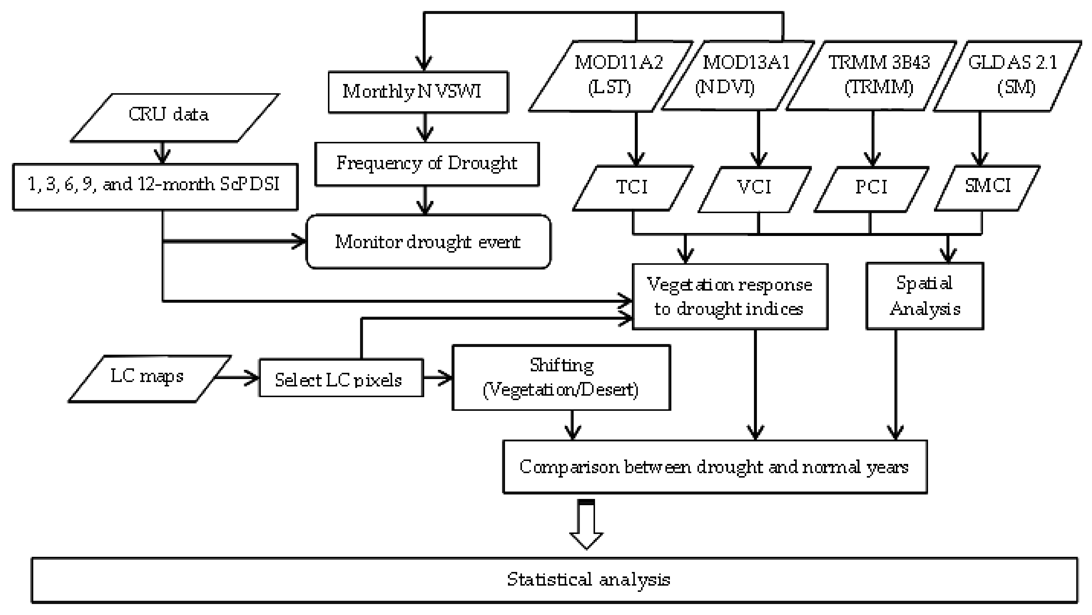
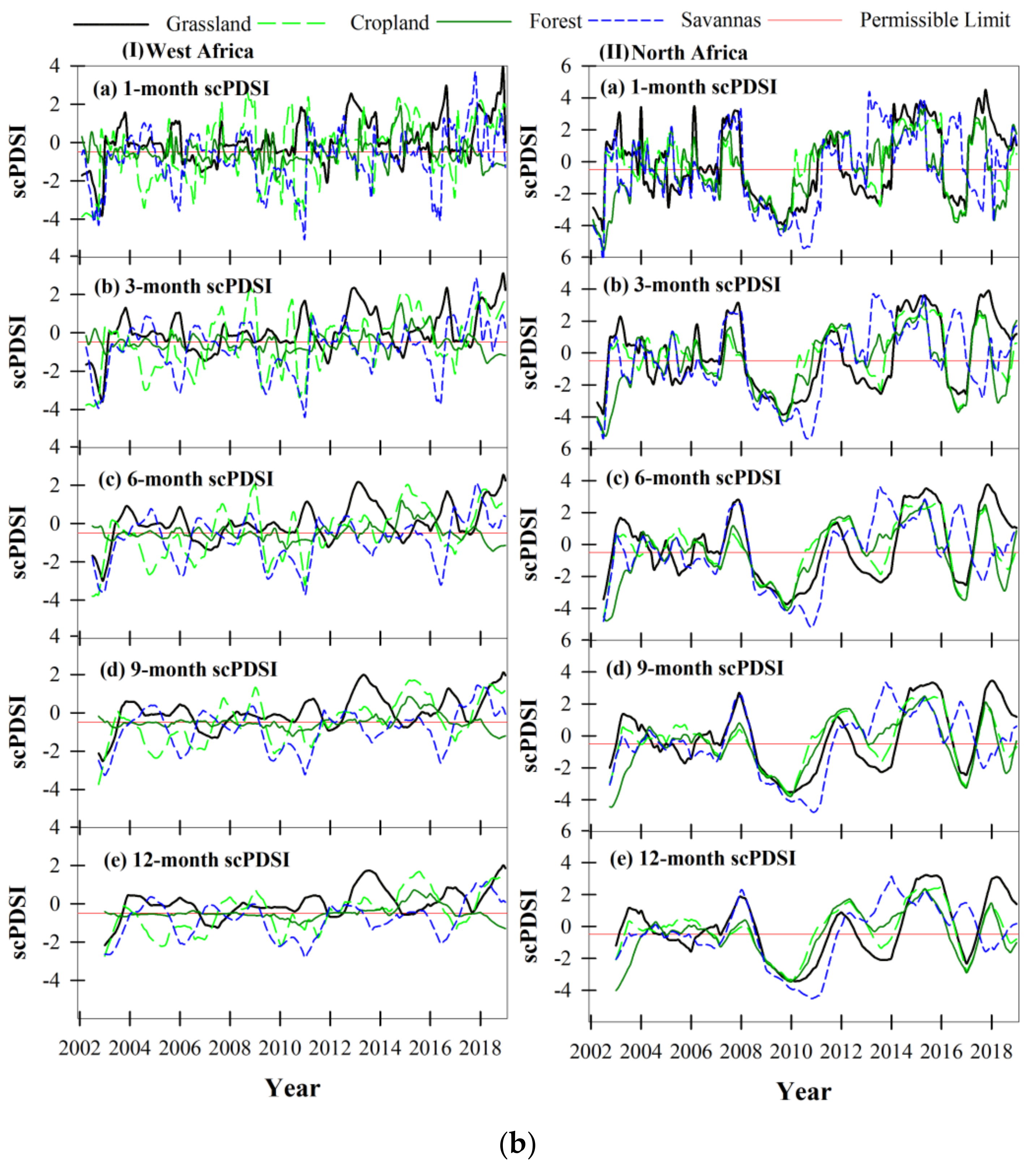
- To evaluate the efficiency of scPDSI at one-, three-, six-, nine-, and 12-month timescales for drought monitoring in (NW) regions of the study area from 2002 to 2018.
- (2)
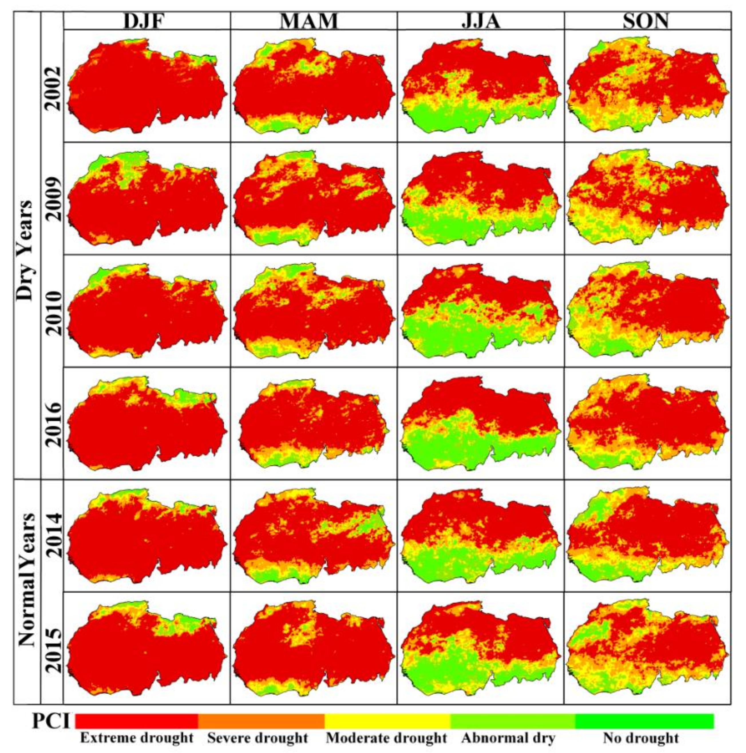
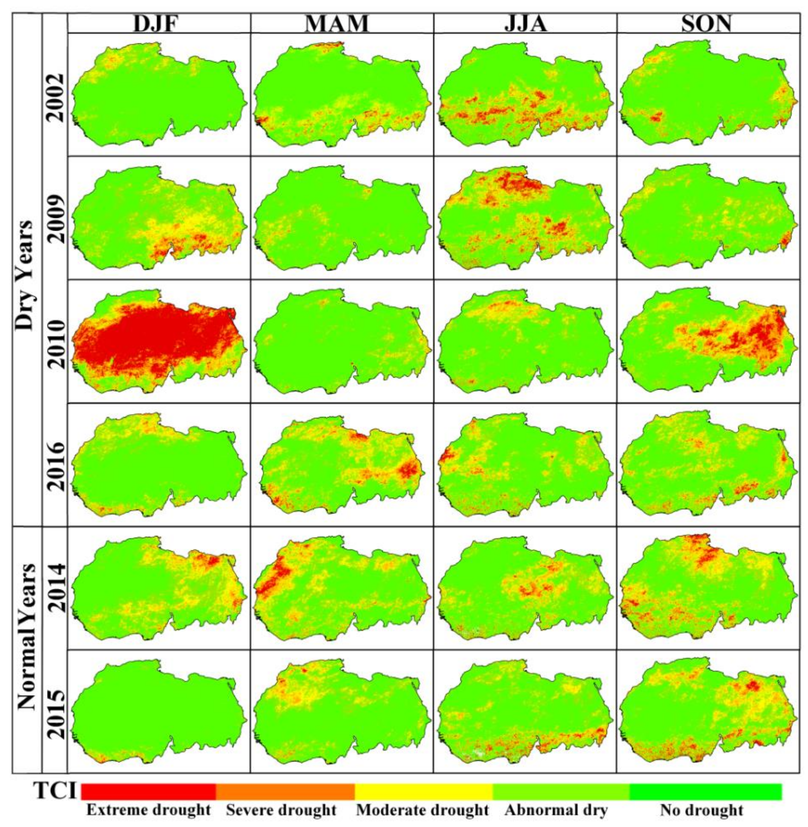
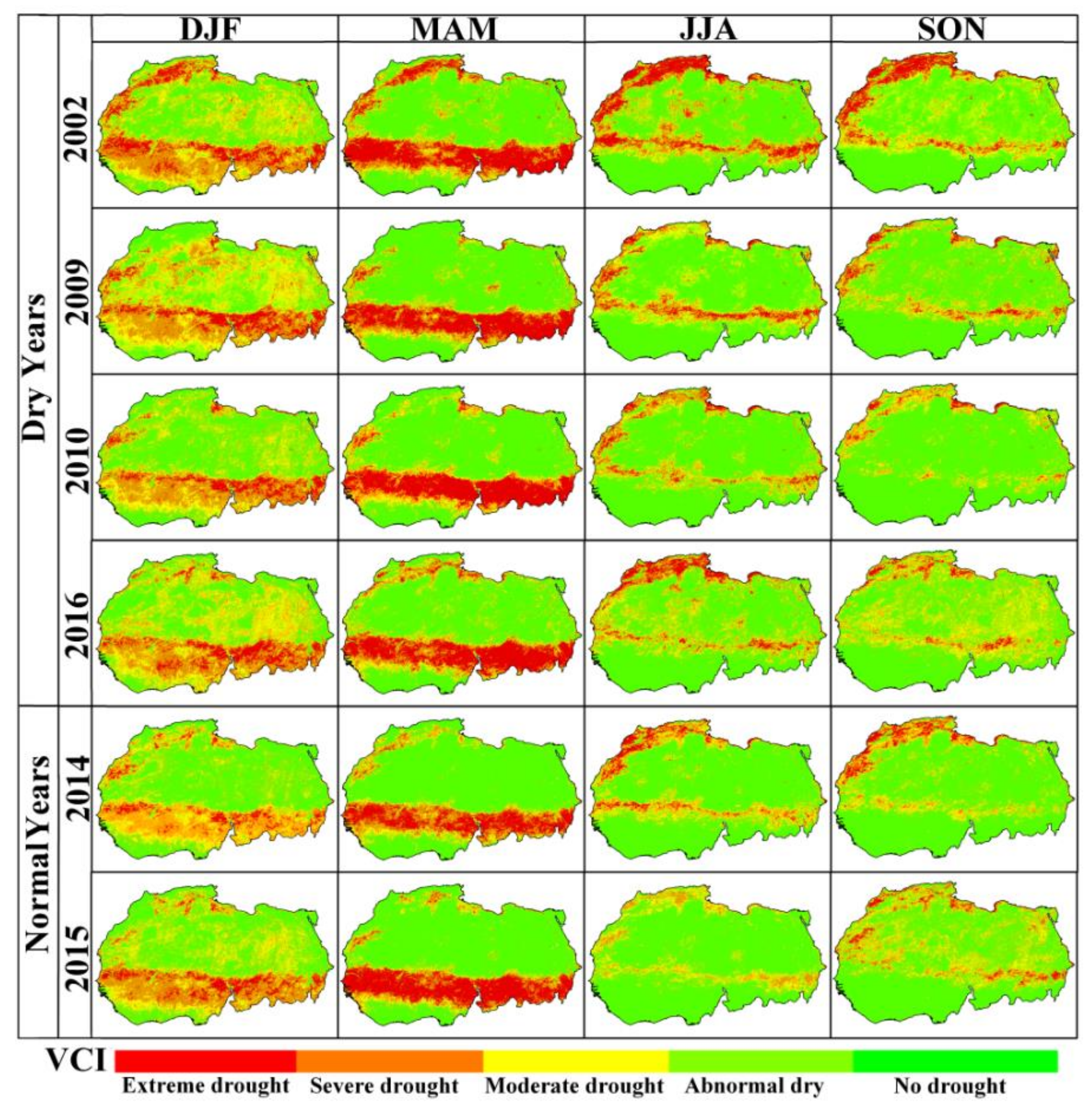
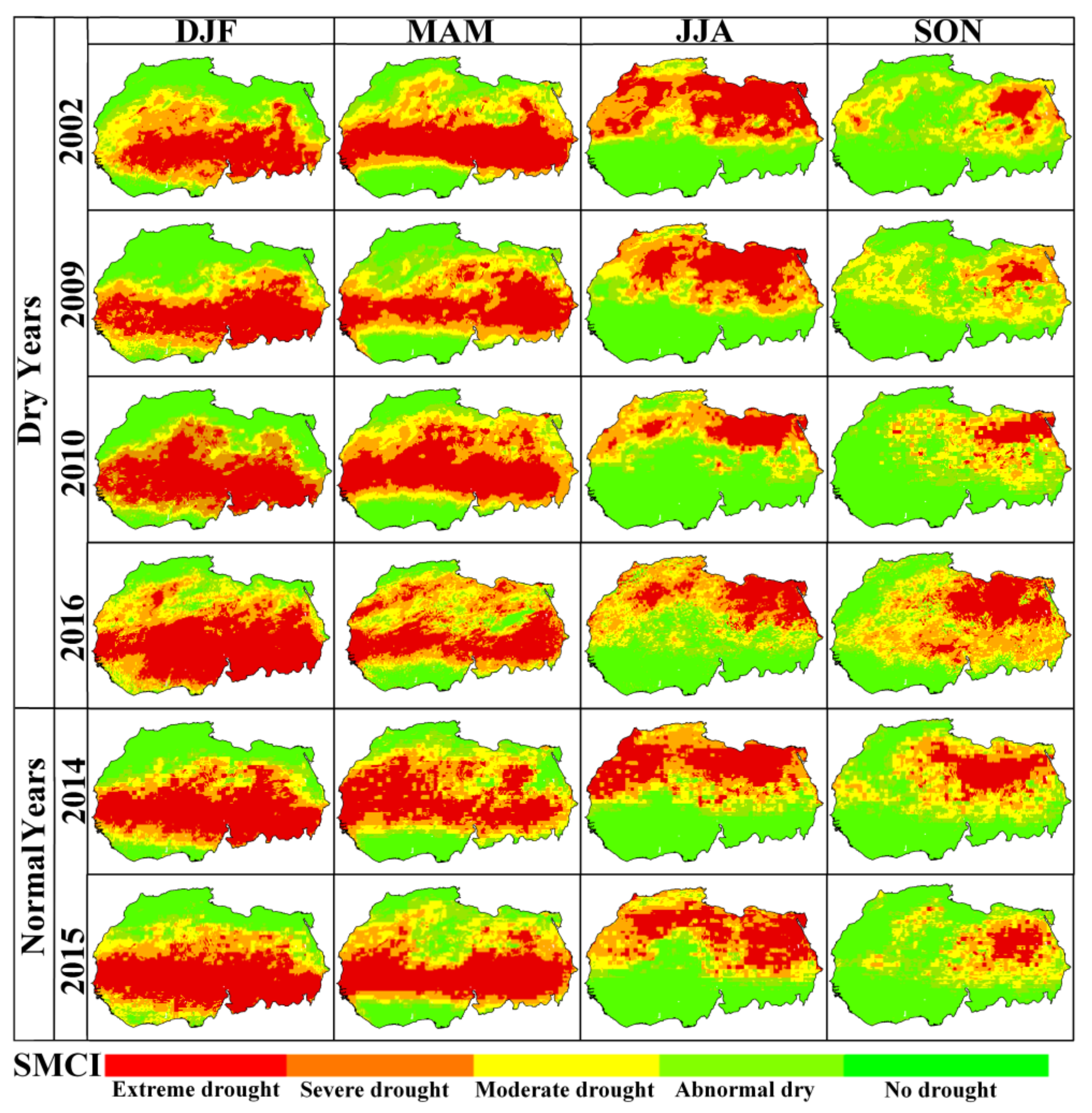
- To evaluate the spatiotemporal patterns of seasonal PCI, TCI, VCI, and SMCI indices, and to compare the shifting between vegetation and desert during four dry years and two normal years.
- (3)
- To monitor the impact of drought on local vegetation and determine which vegetation cover type is most vulnerable to drought risk.
2. Materials and Methods
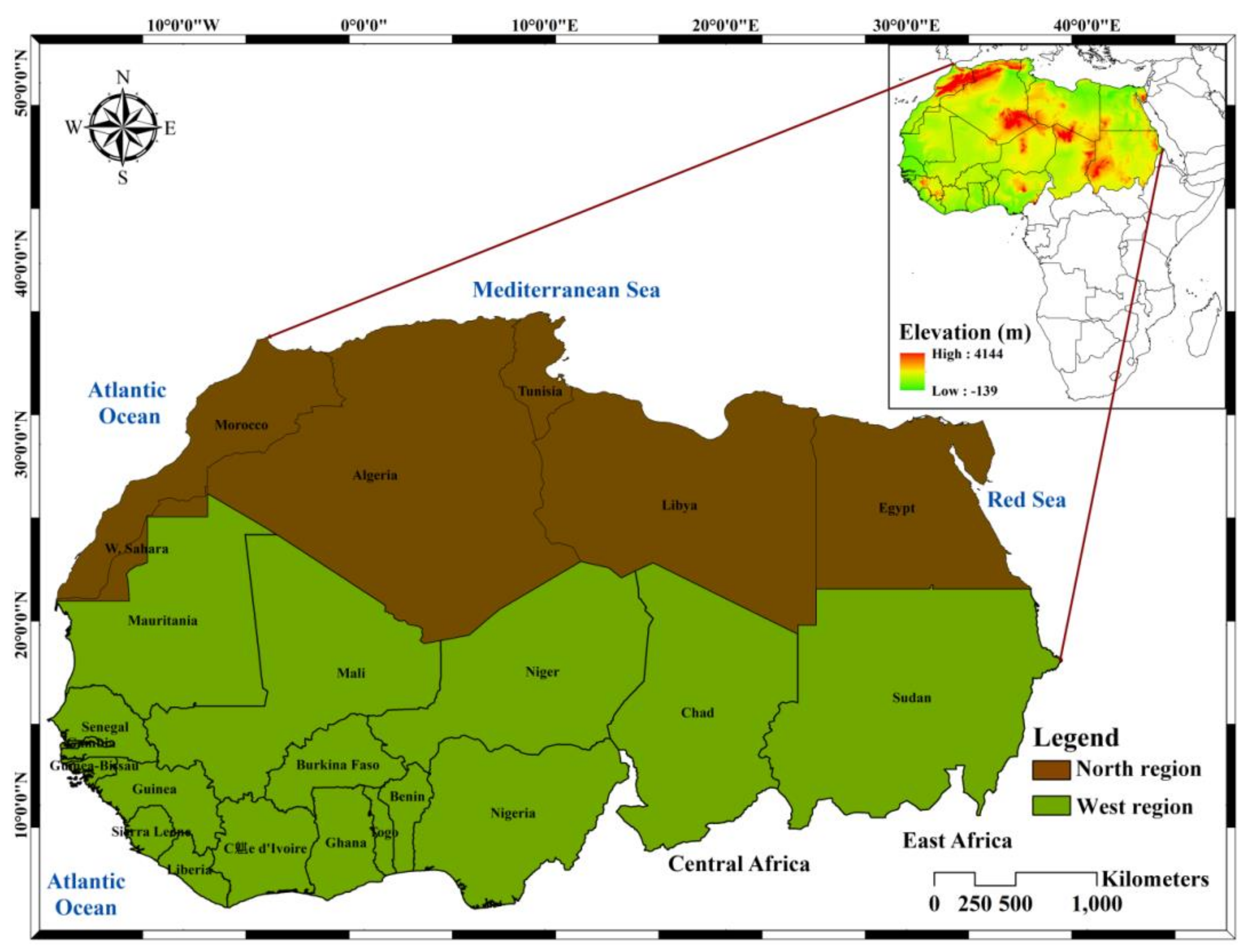
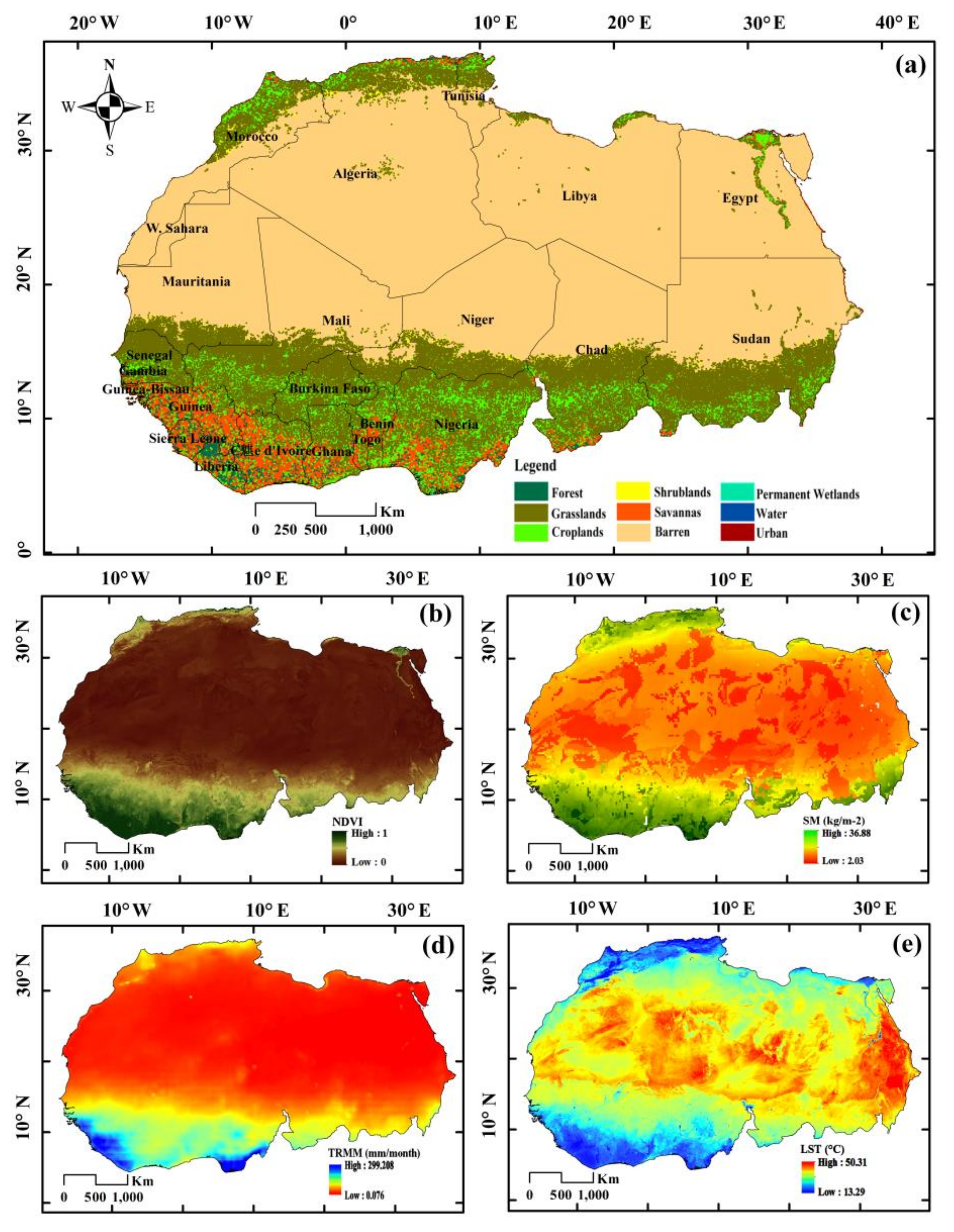
2.1. Study Area
2.2. scPDSI (Self-Calibrating Palmer Drought Severity Index)
2.3. TRMM Precipitation
2.4. NDVI and LST
2.5. SM (Soil Moisture)
2.6. NVSWI (Normalized Vegetation Supply Water Index)
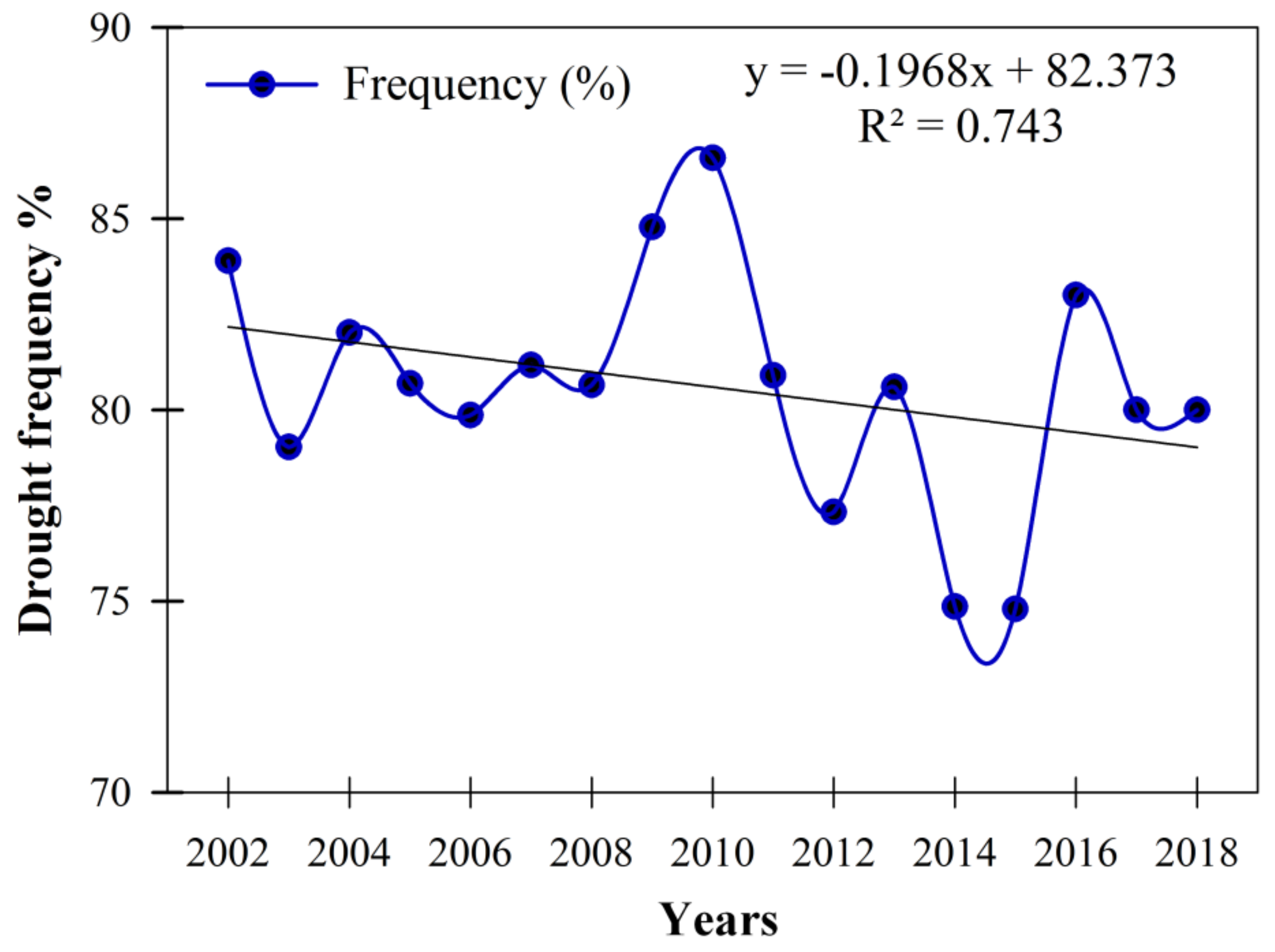
2.7. Drought Frequency
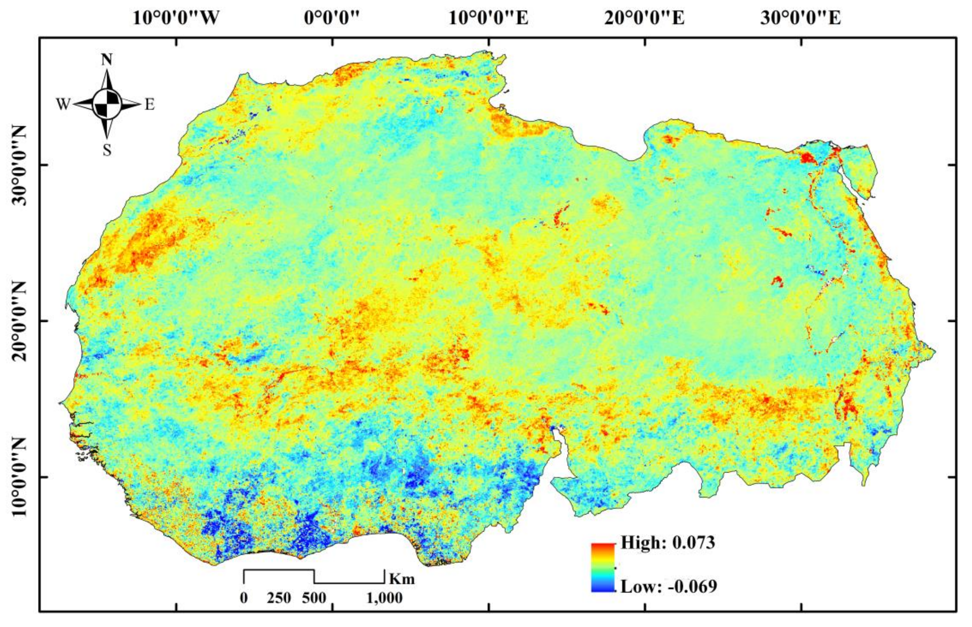
2.8. Tendency Rate of Drought
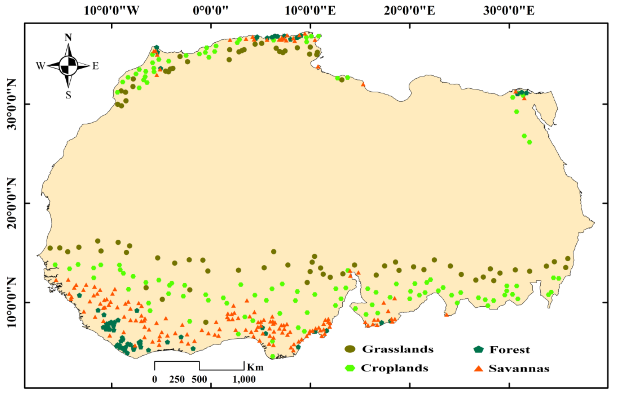
2.9. Selection of Land Cover Pixels
3. Results
3.1. Drought in North and West Africa during 2002‒2018
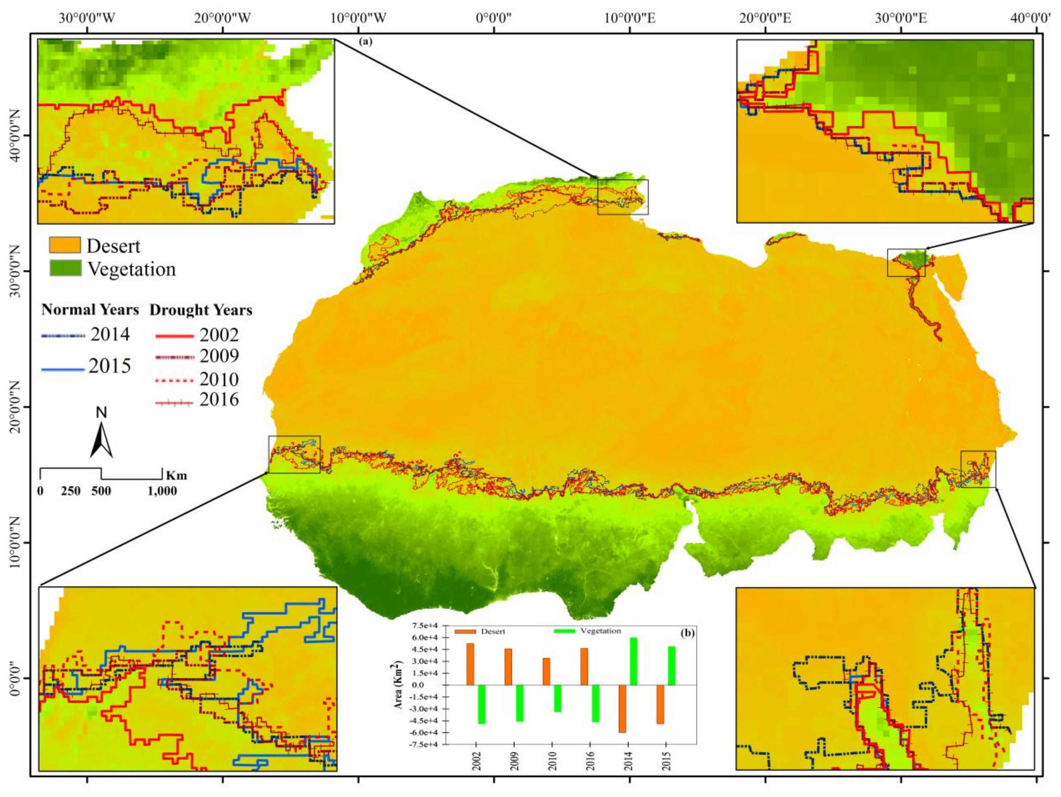
3.2. Shifting between Vegetation and Desert During Dry and Normal Years
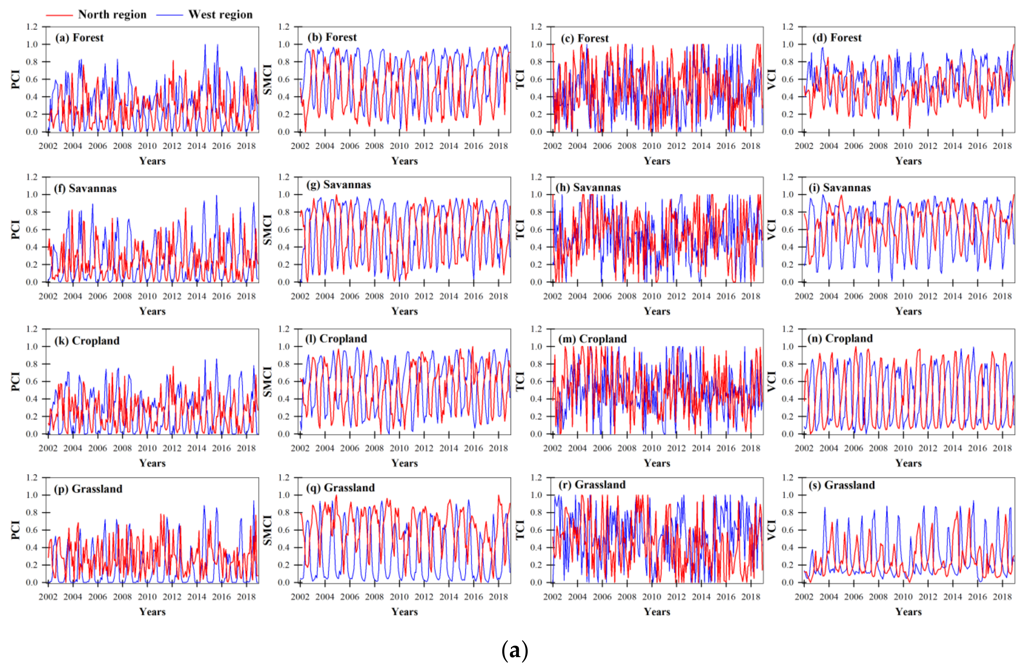
3.3. Temporal and Spatial Comparisons of Remote Sensing Drought Indices
3.4. Vegetation Response to scPDSI, PCI, TCI, VCI and SMCI
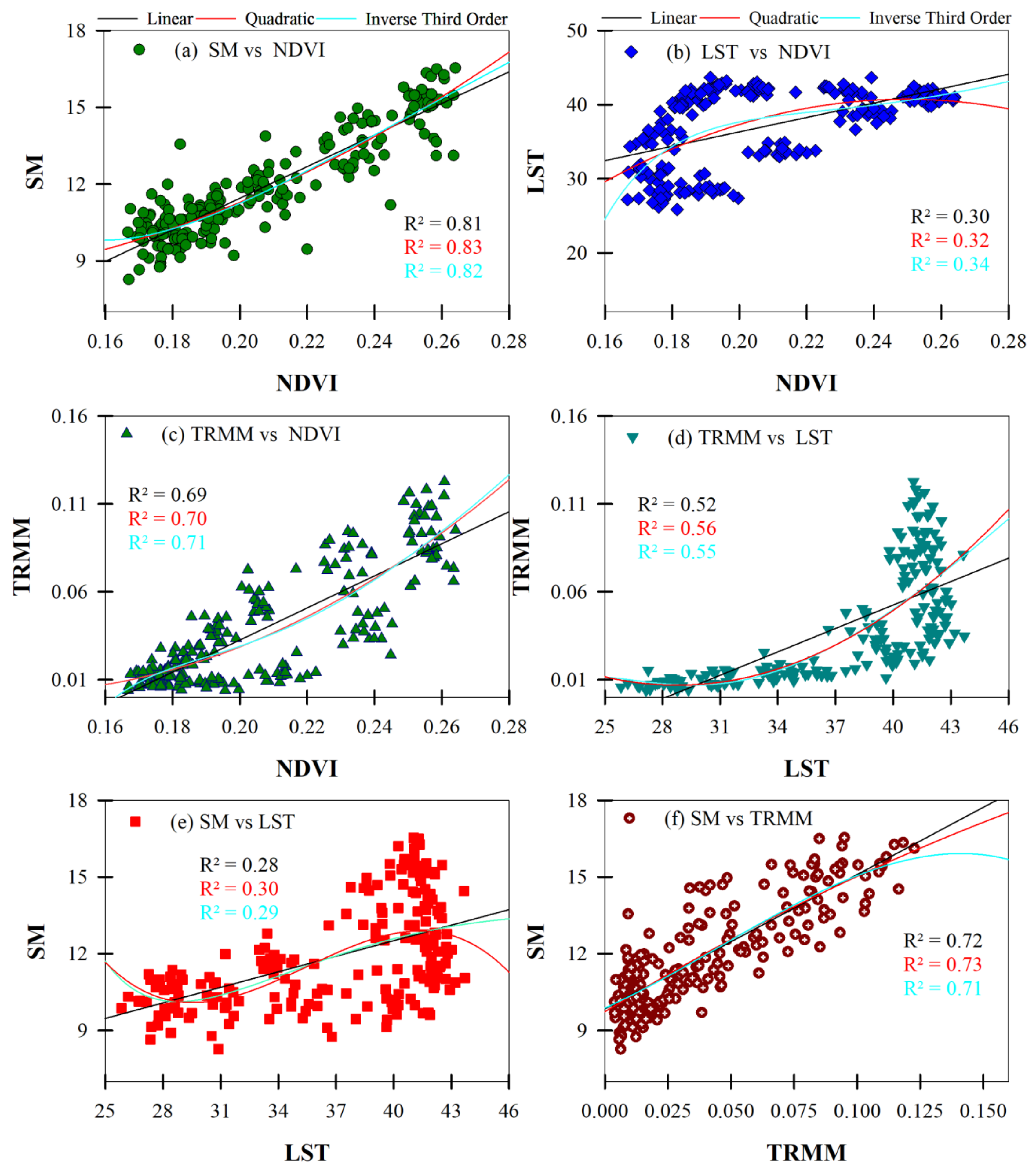
3.5. Correlation Analysis
4. Discussion
5. Conclusions
Author Contributions
Funding
Acknowledgments
Conflicts of Interest
References
- Wilhite, D.A. Drought as a natural hazard: Concepts and denitions. In Drought, A Global Assessment; Wilhite, D.A., Ed.; Routledge: London, UK, 2000; Volume I, pp. 3–18. [Google Scholar]
- Igbawua, T.; Zhang, J.; Chang, Q.; Yao, F. Vegetation dynamics in relation with climate over Nigeria from 1982 to 2011. Environ. Earth Sci. 2016, 75, 518–533. [Google Scholar] [CrossRef]
- Igbawua, T.; Zhang, J.; Yao, F.; Zhang, D. Assessment of moisture budget over West Africa using MERRA-2’s aerological model and satellite data. Clim. Dyn. 2019, 52, 83–106. [Google Scholar] [CrossRef]
- Kalisa, W.; Zhang, J.; Igbawua, T.; Ujoh, F.; Ebohon, O.J.; Namugiza, J. Spatio-temporal analysis of drought and return periods over the East African region using Standardized Precipitation Index from 1920 to 2016. Agric. Water Manag. 2020, 237, 106195. [Google Scholar] [CrossRef]
- Bayarjargal, Y.; Karnieli, A.; Bayasgalan, M.; Khudulmur, S.; Gandush, C.; Tucker, C.J. A comparative study of NOAA-AVHRR derived drought indices using change vector analysis. Remote Sens. Environ. 2006, 105, 9–22. [Google Scholar] [CrossRef]
- Zhang, J.; Xu, Y.; Yao, F.; Wang, P.; Guo, W. Advances in estimation methods of vegetation water content based on optical remote sensing techniques. Sci. China Technol. Sci. 2010, 53, 1159–1167. [Google Scholar] [CrossRef]
- Yang, W. Drought Analysis Under Climate Change by Application of Drought Indices and Copulas. Master’s Thesis, Portland State University, Portland, OR, USA, 2010. [Google Scholar]
- Du, L.; Tian, Q.; Yu, T.; Meng, Q.; Jancso, T.; Udvardy, P.; Huang, Y. A comprehensive drought monitoring method integrating MODIS and TRMM data. Int. J. Appl. Earth Obs. Geoinf. 2013, 23, 245–253. [Google Scholar] [CrossRef]
- Udmale, P.; Ichikawa, Y.; Manandhar, S.; Ishidaira, H.; Kiem, A. Farmers perception of drought impacts, local adaptation and administrative mitigation measures in Maharashtra State, India. Int. J. Disast. Risk Sc. 2014, 10, 250–269. [Google Scholar] [CrossRef] [Green Version]
- IPCC. Summary for Policymakers. In Climate Change 2013: The Physical Science Basis. Contribution of Working Group I to the Fifth Assessment Report of the Intergovernmental Panel on Climate Change; Cambridge University Press: Cambridge, UK, 2013; Available online: https://www.ipcc.ch/site/assets/uploads/2018/02/WG1AR5_SPM_FINAL.pdf (accessed on 1 November 2020).
- Maximilian, S.; Landmann, T.; Cornish, N.; Wetzel, K.; Siebert, S.; Franke, J. A Spatially Transferable Drought Hazard and Drought Risk Modeling Approach Based on Remote Sensing Data. Remote Sens. 2020, 12, 237. [Google Scholar] [CrossRef] [Green Version]
- Masih, I.; Maskey, S.; Mussá, F.E.F.; Trambauer, P. A review of droughts on the African continent: A geospatial and long-term perspective. Hydrol. Earth Syst. Sci. 2014, 18, 3635–3649. [Google Scholar] [CrossRef] [Green Version]
- Amri, R.; Zribi, M.; Duchemin, B.; Lili-Chabaane, Z.; Gruhier, C.; Chebouni, A. Analysis of vegetation behavior in a semi-arid region, using SPOT-VEGETATION NDVI data. Remote Sens. 2011, 3, 2568–2590. [Google Scholar] [CrossRef] [Green Version]
- Zribi, M.; Dridi, G.; Amri, R.; Lili-Chabaane, Z. Analysis of the Effects of Drought on Vegetation Cover in a Mediterranean Region through the Use of SPOT-VGT and TERRA-MODIS Long Time Series. Remote Sens. 2016, 8, 992. [Google Scholar] [CrossRef] [Green Version]
- Blakeley, S.L.; Sweeney, S.; Husak, G.; Harrison, L.; Funk, C.; Peterson, P.; Osgood, D.E. Identifying Precipitation and Reference Evapotranspiration Trends in West Africa to Support Drought Insurance. Remote Sens. 2020, 12, 2432. [Google Scholar] [CrossRef]
- Nicholson, S.E. The West African Sahel: A review of recent studies on the rainfall regime and its inter-annual variability. ISRN Meteorol. 2013, 453521. [Google Scholar] [CrossRef]
- Touchan, R.; Anchukaitis, K.J.; Meko, D.M.; Sabir, M.; Attalah, S.; Aloui, A. Spatiotemporal drought variability in northwestern Africa over the last nine centuries. Clim. Dyn. 2011, 37, 237–252. [Google Scholar] [CrossRef]
- Shiferaw, B.; Tesfaye, K.; Kassie, M.; Abate, T.; Prasanna, B.M.; Menkir, A. Managing vulnerability to drought and enhancing livelihood resilience in sub-Saharan Africa: Technological, institutional and policy options. Weather Clim. Extrem. 2014, 3, 67–79. [Google Scholar] [CrossRef] [Green Version]
- Bhavani, R.; Vordzorgbe, S.; Owor, M.; Bousquet, F. Report on the Disaster Risk Reduction in the Sub-Saharan Africa Region. The World Bank. 2008. Available online: https://www.unisdr.org/files/2229_DRRinSubSaharanAfricaRegion.pdf (accessed on 1 November 2020).
- Brown, C.; Meeks, R.; Hunu, K. Hydroclimate risk to economic growth in sub-Saharan Africa. Clim. Chang. 2011, 106, 621–647. [Google Scholar] [CrossRef]
- Hellmuth, M.E.; Moorhead, A.; Thomas, M.C.; Williams, J. Climate Risk Management in Africa: Learning from Practice; International Research Institute for Climate and Society (IRI), Columbia University: New York, NY, USA, 2007; Available online: https://iri.columbia.edu/wp-content/uploads/2013/07/Climate-and-Society-No1_en.pdf (accessed on 2 November 2020).
- Kim, J.S.; Jain, S.; Lee, J.H.; Chen, H.; Park, S.Y. Quantitative vulnerability assessment of water quality to extreme drought in a changing climate. Ecol. Indic. 2019, 103, 688–697. [Google Scholar] [CrossRef]
- Palmer, W.C. Meteorological Drought; Research Paper No. 45; U.S. Department of Commerce Weather Bureau: Washington, DC, USA, 1965. Available online: https://www.ncdc.noaa.gov/temp-and-precip/drought/docs/palmer.pdf (accessed on 2 November 2020).
- McKee, T.B.; Doesken, N.J.; Kleist, J. The relationship of drought frequency and duration to time scales. In Proceedings of the 8th Conference on Applied Climatology, Anaheim, CA, USA, 17–22 January 1993; pp. 179–184. [Google Scholar]
- Beguería, S.; López-Moreno, J.I. A multiscalar drought index sensitive to global warming: The standardized precipitation evapotranspiration index. J. Clim. 2010, 23, 1696–1718. [Google Scholar] [CrossRef] [Green Version]
- Thornthwaite, C.W.; Mather, J.A.; Thornthwaite, W. The Water Balance: Publications in Climatology, Laboratory of Climatology; Climatol: Centerton, NJ, USA, 1955; Volume 8. Available online: https://books.google.fr/books/about/The_Water_Balance.html?id=DTdtcgAACAAJ&redir_esc=y (accessed on 3 November 2020).
- Zhao, H.; Gao, G.; An, W.; Zou, X.; Li, H.; Hou, M. Timescale differences between SC-PDSI and SPEI for drought monitoring in China. Phys. Chem. Earth 2015, 102, 48–58. [Google Scholar] [CrossRef]
- Wells, N.; Goddard, S.; Hayes, M.J. A Self-Calibrating Palmer Drought Severity Index. J. Clim. 2004, 17, 2335–2351. [Google Scholar] [CrossRef]
- Hao, C.; Zhang, J.; Yao, F. Combination of multi-sensor remote sensing data for drought monitoring over Southwest China. Int. J. Appl. Earth Obs. Geoinf. 2015, 35, 270–283. [Google Scholar] [CrossRef]
- Xu, P.; Zhou, T.; Zhao, X.; Luo, H.; Gao, S.; Li, Z.; Cao, L. Diverse responses of different structured forest to drought in Southwest China through remotely sensed data. Int. J. Appl. Earth Obs. 2018, 69, 217–225. [Google Scholar] [CrossRef]
- Zhang, J.; Zhou, Z.; Yao, F.; Yang, L.; Hao, C. Validating the Modified Perpendicular Drought Index in North China Region Using in Situ Soil Moisture Measurement. IEEE T Geosci. Remote. 2015, 12, 542–546. [Google Scholar] [CrossRef]
- Dianmin, C.; Shuhe, Z.; Cheng, C.; Zheng, D. Characterization of droughts during 2001–2014 based on remote sensing: A case study of Northeast China. Ecol. Inform. 2017, 39, 56–67. [Google Scholar] [CrossRef]
- Ali, S.; Henchiri, M.; Yao, F.; Zhang, J. Analysis of vegetation dynamics, drought in relation with climate over South Asia from 1990 to 2011. Environ. Sci. Pollut. Res. 2019, 26, 11470–11481. [Google Scholar] [CrossRef]
- Li, X.; Sha, J.; Wang, Z. Comparison of drought indices in the analysis of spatial and temporal changes of climatic drought events in a basin. Environ. Sci. Pollut. Res. 2019, 26, 10695–10707. [Google Scholar] [CrossRef]
- Liu, W.T.; Kogan, F.N. Monitoring regional drought using the Vegetation Condition Index. Int. J. Remote Sens. 1996, 17, 2761–2782. [Google Scholar] [CrossRef]
- Faridatul, M.I.; Ahmed, B. Assessing Agricultural Vulnerability to Drought in a Heterogeneous Environment: A Remote Sensing-Based Approach. Remote Sens. 2020, 12, 3363. [Google Scholar] [CrossRef]
- Qu, C.; Hao, X.; Qu, J.J. Monitoring Extreme Agricultural Drought over the Horn of Africa (HOA) Using Remote Sensing Measurements. Remote Sens. 2019, 11, 902. [Google Scholar] [CrossRef] [Green Version]
- Kogan, F.N. Droughts of the Late 1980s in the United States as Derived from NOAA Polar Orbiting Satellite Data. Bull. Amer. Meteor. Soc. 1995, 76, 655–668. [Google Scholar] [CrossRef] [Green Version]
- Ahmadalipour, A.; Moradkhani, H. Multi-dimensional assessment of drought vulnerability in Africa: 1960–2100. Sci. Total Environ. 2018, 644, 520–535. [Google Scholar] [CrossRef] [PubMed]
- Ahmadalipour, A.; Moradkhani, H. Escalating heat-stress mortality risk due to global warming in the Middle East and North Africa (MENA). Environ. Int. 2018, 117, 215–225. [Google Scholar] [CrossRef] [PubMed]
- Buma, W.G.; Lee, S.-I. Multispectral Image-Based Estimation of Drought Patterns and Intensity around Lake Chad, Africa. Remote Sens. 2019, 11, 2534. [Google Scholar] [CrossRef] [Green Version]
- Winkler, K.; Gessner, U.; Hochschild, V. Identifying Droughts Affecting Agriculture in Africa Based on Remote Sensing Time Series between 2000–2016: Rainfall Anomalies and Vegetation Condition in the Context of ENSO. Remote Sens. 2017, 9, 831. [Google Scholar] [CrossRef] [Green Version]
- Measho, S.; Chen, B.; Trisurat, Y.; Pellikka, P.; Guo, L.; Arunyawat, S.; Tuankrua, V.; Ogbazghi, W.; Yemane, T. Spatio-Temporal Analysis of Vegetation Dynamics as a Response to Climate Variability and Drought Patterns in the Semiarid Region, Eritrea. Remote Sens. 2019, 11, 724. [Google Scholar] [CrossRef] [Green Version]
- Zhao, H.; Ma, Y. Evaluating the Drought-Monitoring Utility of Four Satellite-Based Quantitative Precipitation Estimation Products at Global Scale. Remote Sens. 2019, 11, 2010. [Google Scholar] [CrossRef] [Green Version]
- AghaKouchak, A.; Farahmand, A.; Melton, F.S.; Teixeira, J.; Anderson, M.C.; Wardlow, B.D.; Hain, C.R. Remote sensing of drought: Progress, challenges and opportunities. Rev. Geophys. 2015, 53, 452–480. [Google Scholar] [CrossRef] [Green Version]
- Bobadoye, A.O. Assessing Vulnerability to Climate Change and the Impact of Drought on Vegetation Productivity in West Africa. Ph.D. Thesis, University of Nairobi, Nairobi, Kenya, 2018. [Google Scholar] [CrossRef]
- NourEldeen, N.; Mao, K.; Yuan, Z.; Shen, X.; Xu, T.; Qin, Z. Analysis of the Spatiotemporal Change in Land Surface Temperature for a Long-Term Sequence in Africa (2003–2017). Remote Sens. 2020, 12, 488. [Google Scholar] [CrossRef] [Green Version]
- Henchiri, M.; Shahzad, A.; Essifi, B.; Kalisa, W.; Zhang, S.; Bai, Y. Monitoring land cover change detection with NOAA-AVHRR and MODIS remotely sensed data in the North and West of Africa from 1982 to 2015. Environ. Sci. Pollut. Res. 2019, 6, 5873–5889. [Google Scholar] [CrossRef]
- Zhao, M.; Velicogna, G.A.; Kimball, J.S. A global gridded dataset of GRACE drought severity index for 2002–2014: Comparison with PDSI and SPEI and a case study of the Australia Millennium Drought. J. Hydrometeor. 2017, 18, 2117–2129. [Google Scholar] [CrossRef] [Green Version]
- Van der Schrier, G.; Barichivich, J.; Briffa, K.R.; Jones, P.D. A scPDSI-based global data set of dry and wet spells for 1901–2009. J. Geophys. Res. Atmos. 2013, 118, 4025–4048. [Google Scholar] [CrossRef]
- Eklundh, L.; Jönsson, P. TIMESAT 3.2 with Parallel Processing Software Manual; Lund University and Malmo University: Lund, Sweden, 2015; Available online: http://web.nateko.lu.se/timesat/docs/TIMESAT32_software_manual.pdf (accessed on 12 August 2020).
- Ali, S.; Tong, D.; Xu, Z.T.; Henchiri, M.; Wilson, K.; Siqi, S.; Zhang, J. Characterization of drought monitoring events through MODIS-and TRMM-based DSI and TVDI over South Asia during 2001–2017. Environ. Sci. Pollut. Res. Int. 2019, 32, 33568–33581. [Google Scholar] [CrossRef] [PubMed]
- Ghoneim, E.; Dorofeeva, A.; Benedetti, M.; Gamble, D.; Leonard, L.; AbuBakr, M. Vegetation Drought Analysis in Tunisia: A Geospatial Investigation. J. Atmos. Sci. 2017, 1, 2. [Google Scholar] [CrossRef]
- Hazaymeh, K.; Hassan, Q. Remote sensing of agricultural drought monitoring: A state of art review. AIMS Environ. Sci. 2016, 3, 604–630. [Google Scholar] [CrossRef]
- Peters, A.J.; Walter-Shea, E.A.; Ji, L.; Vina, A.; Hayes, M.; Svoboda, M.D. Drought monitoring with NDVI-based standardized vegetation index. Photogramm. Eng. Remote Sens. 2002, 68, 71–75. [Google Scholar]
- Liu, Q.; Zhang, S.; Zhang, H.; Bai, Y.; Zhang, J. Monitoring drought using composite drought indices based on remote sensing. Sci. Total Environ. 2020, 711, 13585. [Google Scholar] [CrossRef] [PubMed]
- Abbas, S.; Nichol, J.E.; Qamer, F.M.; Xu, J. Characterization of drought development through remote sensing: A case study in central Yunnan, China. Remote Sens. 2014, 6, 4998–5018. [Google Scholar] [CrossRef] [Green Version]
- Ren, S.; Qin, Q.; Ren, H.; Sui, J.; Zhang, Y. Heat and Drought Stress Advanced Global Wheat Harvest Timing from 1981–2014. Remote Sens. 2019, 11, 971. [Google Scholar] [CrossRef] [Green Version]
- Foley, A.; Coe, M.T.; Scheffer, M.; Wang, G. Regime Shifts in the Sahara and Sahel: Interactions between Ecological and Climatic Systems in Northern Africa. Ecosystems 2003, 6, 524–539. [Google Scholar] [CrossRef]
- Nanzad, L.; Zhang, J.; Tuvdendorj, B.; Nabil, M.; Zhang, S.; Bai, Y. NDVI anomaly for drought monitoring and its correlation with climate factors over Mongolia from 2000 to 2016. J. Arid Environ. 2019, 164, 69–77. [Google Scholar] [CrossRef]
- Drori, R.; Dan, H.; Sprintsin, M.; Sheffer, E. Precipitation-Sensitive Dynamic Threshold: A New and Simple Method to Detect and Monitor Forest and Woody Vegetation Cover in Sub-Humid to Arid Areas. Remote Sens. 2020, 12, 1231. [Google Scholar] [CrossRef] [Green Version]
- Zhang, A.; Jia, G. Monitoring meteorological drought in semiarid regions using multi-sensor microwave remote sensing data. Remote Sens. Environ. 2013, 134, 12–23. [Google Scholar] [CrossRef]
- Zhang, L.; Jiao, W.; Zhang, H.; Huang, C.; Tong, Q. Studying drought phenomena in the Continental United States in 2011 and 2012 using various drought indices. Remote Sens. Environ. 2017, 190, 96–106. [Google Scholar] [CrossRef]
- Onyutha, C. On Rigorous Drought Assessment Using Daily Time Scale: Non-Stationary Frequency Analyses, Revisited Concepts, and a New Method to Yield Non-Parametric Indices. Hydrology 2017, 4, 48. [Google Scholar] [CrossRef] [Green Version]
- Kalisa, W.; Igbawua, T.; Henchiri, M.; Ali, S.; Zhang, S.; Bai, Y.; Zhang, J. Assessment of climate impact on vegetation dynamics over East Africa from 1982 to 2015. Sci. Rep. 2019, 9, 16865. [Google Scholar] [CrossRef] [Green Version]
- Javed, T.; Yao, N.; Chen, X.; Suon, S.; Li, Y. Drought evolution indicated by meteorological and remote-sensing drought indices under different land cover types in China. Environ. Sci. Pollut. Res. 2020, 27, 4258–4274. [Google Scholar] [CrossRef]
- Vicenteserrano, S.M.; Beguería, S.; Lópezmoreno, J.I.; Angulo, M.; Kenawy, A.E. A new global 0.58 gridded dataset (1901–2006) of a multiscalar drought index: Comparison with current drought index datasets based on the Palmer drought severity index. J. Hydrometeor. 2010, 11, 1033–1043. [Google Scholar] [CrossRef] [Green Version]
- Waha, K.; Krummenauer, L.; Adams, S.; Aich, V.; Baarsch, F.; Coumou, D.; Fader, M.; Hoff, H.; Jobbins, G.; Marcus, R. Climate change impacts in the Middle East and Northern Africa (MENA) region and their implications for vulnerable population groups. Reg. Environ. Change 2017, 17, 1623–1638. [Google Scholar] [CrossRef]
- Abera, W.; Tamene, L.; Abegaz, A.; Solomon, D. Understanding climate and land surface changes impact on water resources using Budyko framework and remote sensing data in Ethiopia. J. Arid Environ. 2019, 167, 56–64. [Google Scholar] [CrossRef]
- Huang, J.P.; Yu, H.P.; Guan, X.D.; Wang, G.Y.; Guo, R.X. Accelerated dryland expansion under climate change. Nat. Clim. Chang. 2016, 6, 166–171. [Google Scholar] [CrossRef]
- Dai, A.; Zhao, T.; Chen, J. Climate Change and Drought: A Precipitation and Evaporation Perspective. Curr. Clim. Chang. Rep. 2018, 4, 301–312. [Google Scholar] [CrossRef]
- Lehner, F.; Coats, S.; Stocker, T.F.; Pendergrass, A.G.; Sanderson, M.; Raible, C.C.; Smerdon, J.E. Projected drought risk in 1.5 °C and 2 °C warmer climates. Geophys. Res. Lett. 2017, 44, 7419–7428. [Google Scholar] [CrossRef]
- Gómez-Giráldez Pedro, J.; Pérez-Palazón María, J.; Polo María, J.; González-Dugo María, P. Monitoring Grass Phenology and Hydrological Dynamics of an Oak–Grass Savanna Ecosystem Using Sentinel-2 and Terrestrial Photography. Remote Sens. 2020, 12, 600. [Google Scholar] [CrossRef] [Green Version]
- Rousta, I.; Olafsson, H.; Moniruzzaman, M.; Zhang, H.; Liou, Y.-A.; Mushore, T.D.; Gupta, A. Impacts of Drought on Vegetation Assessed by Vegetation Indices and Meteorological Factors in Afghanistan. Remote Sens. 2020, 12, 2433. [Google Scholar] [CrossRef]
- Ford, T.; Quiring, S.; Thakur, B.; Jogineedi, R.; Houston, A.; Yuan, S.; Kalra, A.; Lock, N. Evaluating Soil Moisture-Precipitation Interactions Using Remote Sensing: A Sensitivity Analysis. J. Hydrometeorol. 2018, 19, 1237–1253. [Google Scholar] [CrossRef]
- Sun, D.; Kafatos, M. Note on the NDVI-LST relationship and the use of temperature-related drought indices over North America. J. Geophys. Res. Lett. 2007, 34, L24406. [Google Scholar] [CrossRef] [Green Version]
- Swain, S.; Wardlow, B.D.; Narumalani, S.; Tadesse, T.; Callahan, K. Assessment of Vegetation Response to Drought in Nebraska Using Terra MODIS Land Surface Temperature and Normalized Difference Vegetation Index. GISci. Remote Sens. 2011, 48, 432–455. [Google Scholar] [CrossRef]
- Dracup, J.A.; Lee, K.S.; Paulson, E.G. on the definition of droughts. Water Resour. Res. 1980, 16, 289–296. [Google Scholar] [CrossRef]



| PDSI | Class |
|---|---|
| −0.49 to −0.99 | Incipient drought |
| −1.00 to −1.99 | Mild drought |
| −2.00 to −2.99 | Moderate drought |
| −3.00 to −3.99 | Severe drought |
| ≤−4.0 | Extreme drought |
| Severe | Moderate | Slight | Normal | Wet | |
|---|---|---|---|---|---|
| NVSWI | <0.20 | 0.20–0.40 | 0.40–0.60 | 0.60–0.80 | >0.80 |
| Map Unit | Area | |
|---|---|---|
| Km2 | % | |
| Evergreen Broadleaf Forest | 15,9132.1 | 0.92 |
| Deciduous Broadleaf Forest | 9208.81 | 0.05 |
| Open Shrublands | 182,273.2 | 1.05 |
| Woody Savannas | 118,926.6 | 0.69 |
| Savannas | 943,824.9 | 5.45 |
| Grasslands | 3,201,880 | 18.48 |
| Permanent Wetlands | 13,888.51 | 0.08 |
| Croplands | 1,351,932 | 7.8 |
| Urban and Built-up | 9331.29 | 0.05 |
| Barren or Sparsely Vegetated | 11,337,555 | 65.43 |
| Water | 604.58 | 0.001 |
| Total area | 17,328,557 | 100 |
| Vegetation | Region | Index | ScPDSI-1 | ScPDSI-3 | ScPDSI-6 | ScPDSI-9 | ScPDSI-12 | PCI | SMCI | TCI |
|---|---|---|---|---|---|---|---|---|---|---|
| Grasslands | North | PCI | 0.58 | 0.56 | 0.55 | 0.53 | 0.52 | - | - | - |
| SMCI | 0.56 | 0.54 | 0.54 | 0.52 | 0.50 | 0.59 | - | - | ||
| TCI | 0.10 | 0.08 | 0.09 | 0.07 | 0.08 | 0.09 | 0.07 | - | ||
| VCI | 0.55 | 0.54 | 0.51 | 0.50 | 0.50 | 0.57 | 0.56 | 0.10 | ||
| West | PCI | 0.77 | 0.72 | 0.68 | 0.64 | 0.61 | - | - | - | |
| SMCI | 0.62 | 0.61 | 0.58 | 0.56 | 0.53 | 0.79 | - | - | ||
| TCI | 0.09 | 0.10 | 0.08 | 0.11 | 0.09 | 0.08 | 0.07 | - | ||
| VCI | 0.59 | 0.55 | 0.53 | 0.56 | 0.51 | 0.68 | 0.77 | 0.06 | ||
| Croplands | North | PCI | 0.50 | 0.57 | 0.51 | 0.49 | 0.44 | - | - | - |
| SMCI | 0.51 | 0.55 | 0.53 | 0.51 | 0.50 | 0.58 | - | - | ||
| TCI | 0.04 | 0.05 | 0.07 | 0.07 | 0.05 | 0.10 | 0.08 | - | ||
| VCI | 0.54 | 0.55 | 0.53 | 0.52 | 0.52 | 0.56 | 0.54 | 0.17 | ||
| West | PCI | 0.71 | 0.73 | 0.70 | 0.65 | 0.61 | - | - | - | |
| SMCI | 0.65 | 0.67 | 0.62 | 0.60 | 0.59 | 0.77 | - | - | ||
| TCI | 0.09 | 0.05 | 0.06 | 0.05 | 0.01 | 0.07 | 0.05 | - | ||
| VCI | 0.61 | 0.67 | 0.63 | 0.58 | 0.53 | 0.72 | 0.75 | 0.07 | ||
| Savannas | North | PCI | 0.52 | 0.50 | 0.49 | 0.49 | 0.48 | - | - | - |
| SMCI | 0.51 | 0. 51 | 0.50 | 0.51 | 0.49 | 0.53 | - | - | ||
| TCI | 0.12 | 0.11 | 0.11 | 0.06 | 0.04 | 0.11 | 0.09 | - | ||
| VCI | 0.51 | 0.50 | 0.50 | 0.49 | 0.51 | 0.52 | 0.50 | 0.13 | ||
| West | PCI | 0.65 | 0.61 | 0.52 | 0.53 | 0.51 | - | - | - | |
| SMCI | 0.61 | 0.58 | 0.54 | 0.50 | 0.48 | 0.75 | - | - | ||
| TCI | 0.10 | 0.08 | 0.08 | 0.10 | 0.09 | 0.05 | 0.09 | - | ||
| VCI | 0.55 | 0.54 | 0.53 | 0.50 | 0.48 | 0.69 | 0.72 | 0.018 | ||
| Forest | North | PCI | 0.51 | 0.52 | 0.55 | 0.53 | 0.54 | - | - | - |
| SMCI | 0.49 | 0.53 | 0.53 | 0.50 | 0.51 | 0.59 | - | - | ||
| TCI | 0.09 | 0.09 | 0.10 | 0.08 | 0.04 | 0.05 | 0.03 | - | ||
| VCI | 0.51 | 0.53 | 0.56 | 0.54 | 0.55 | 0.56 | 0.54 | 0.13 | ||
| West | PCI | 0.65 | 0.66 | 0.69 | 0.63 | 0.63 | - | - | - | |
| SMCI | 0.61 | 0.63 | 0.66 | 0.62 | 0.64 | 0.73 | - | - | ||
| TCI | 0.07 | 0.08 | 0.054 | 0.06 | 0.05 | 0.03 | 0.02 | - | ||
| VCI | 0.60 | 0.63 | 0.64 | 0.62 | 0.62 | 0.61 | 0.65 | 0.04 |
| Drought Indices Values | Drought Conditions |
|---|---|
| <10 | Extreme drought |
| 10–20 | Severe drought |
| 20–30 | Moderate drought |
| 30–40 | Abnormal dry |
| >40 | No drought |
Publisher’s Note: MDPI stays neutral with regard to jurisdictional claims in published maps and institutional affiliations. |
© 2020 by the authors. Licensee MDPI, Basel, Switzerland. This article is an open access article distributed under the terms and conditions of the Creative Commons Attribution (CC BY) license (http://creativecommons.org/licenses/by/4.0/).
Share and Cite
Henchiri, M.; Liu, Q.; Essifi, B.; Javed, T.; Zhang, S.; Bai, Y.; Zhang, J. Spatio-Temporal Patterns of Drought and Impact on Vegetation in North and West Africa Based on Multi-Satellite Data. Remote Sens. 2020, 12, 3869. https://doi.org/10.3390/rs12233869
Henchiri M, Liu Q, Essifi B, Javed T, Zhang S, Bai Y, Zhang J. Spatio-Temporal Patterns of Drought and Impact on Vegetation in North and West Africa Based on Multi-Satellite Data. Remote Sensing. 2020; 12(23):3869. https://doi.org/10.3390/rs12233869
Chicago/Turabian StyleHenchiri, Malak, Qi Liu, Bouajila Essifi, Tehseen Javed, Sha Zhang, Yun Bai, and Jiahua Zhang. 2020. "Spatio-Temporal Patterns of Drought and Impact on Vegetation in North and West Africa Based on Multi-Satellite Data" Remote Sensing 12, no. 23: 3869. https://doi.org/10.3390/rs12233869
APA StyleHenchiri, M., Liu, Q., Essifi, B., Javed, T., Zhang, S., Bai, Y., & Zhang, J. (2020). Spatio-Temporal Patterns of Drought and Impact on Vegetation in North and West Africa Based on Multi-Satellite Data. Remote Sensing, 12(23), 3869. https://doi.org/10.3390/rs12233869


