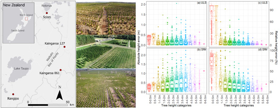
An Assessment of High-Density UAV Point Clouds for the Measurement of Young Forestry Trials
Abstract
Share and Cite
Hartley, R.J.L.; Leonardo, E.M.; Massam, P.; Watt, M.S.; Estarija, H.J.; Wright, L.; Melia, N.; Pearse, G.D. An Assessment of High-Density UAV Point Clouds for the Measurement of Young Forestry Trials. Remote Sens. 2020, 12, 4039. https://doi.org/10.3390/rs12244039
Hartley RJL, Leonardo EM, Massam P, Watt MS, Estarija HJ, Wright L, Melia N, Pearse GD. An Assessment of High-Density UAV Point Clouds for the Measurement of Young Forestry Trials. Remote Sensing. 2020; 12(24):4039. https://doi.org/10.3390/rs12244039
Chicago/Turabian StyleHartley, Robin J. L., Ellen Mae Leonardo, Peter Massam, Michael S. Watt, Honey Jane Estarija, Liam Wright, Nathanael Melia, and Grant D. Pearse. 2020. "An Assessment of High-Density UAV Point Clouds for the Measurement of Young Forestry Trials" Remote Sensing 12, no. 24: 4039. https://doi.org/10.3390/rs12244039
APA StyleHartley, R. J. L., Leonardo, E. M., Massam, P., Watt, M. S., Estarija, H. J., Wright, L., Melia, N., & Pearse, G. D. (2020). An Assessment of High-Density UAV Point Clouds for the Measurement of Young Forestry Trials. Remote Sensing, 12(24), 4039. https://doi.org/10.3390/rs12244039


