1. Introduction
The disturbance regime in the boreal forest is extremely variable. Every year in Siberia, millions of hectares of forest are burned. Forest fires are one of the main factors causing not only long-term, harmful changes in plant ecosystems, but also contribute to the deterioration of living conditions in society, especially in the event of wildfires. Taiga fire is a natural phenomenon. Fires determine the normal, ecological functioning of the forest in this region. Forest fires are an inseparable part of the natural cycle. After the fire, there are favorable conditions for the young generation of trees. Wildfires are important for the indigenous peoples of Siberia. The territory after the wildfire turns into a pasture and people harvest berries for winter stocks. Fires have deep consequences and issues to the transformation of the landscape in the specific context of permafrost. Fire in forest areas where permafrost is spread is considered as an important factor in modeling the surface and influencing geomorphological processes.
Boreal forest plays a big role in the circulation of carbon dioxide in the regional and global scale. Changes in fire regime and climate in this region have already started, and they have an impact on the carbon releasing dynamic not only during the fire, but also years after the fire when the permafrost is thawing [
1,
2]. Forest fires in Russia, in general, and in the Republic of Sakha (Yakutia) are one of the main and most common natural threats. Currently, the area covered by forest fires has increased significantly. According to the results of scientific research, not the least role in the spread of fires is played by the human factor. Almost half of all forest fires that have occurred in Yakutia are caused by humans [
2]. The occurrence and spread of forest fires are influenced by a complex of different factors that mutually reinforce each other and create conditions that contribute to the forest fire.
Geoinformation systems and modern remote sensing methods are a popular and effective means of identifying the most important factors affecting fires. GIS technologies are effective for building the necessary long-term fire safety models in countries such as Canada, the USA, and most of the European countries, where sustainable forest management is wide. GIS forest fire risk models are commonly used, but most of them do not include the human factor [
3]. In Russia, the Nesterov index, from the 1940s is still in use [
4]. There is large interest in the development of an integrated fire hazard assessment system integrated with GIS, remote sensing, meteorological, and government data. A system like that, available for forestry, firefighters, and local authorities, can improve the fight against fires and reduce the damage, thanks to faster detection of fire ignition and focusing on the most endangered places. The purpose of this work was geoinformation modeling the long-term wildfire risk in the Republic of Sakha (Yakutia) on a macro- and microscale. To achieve this goal, the following tasks were defined: (1) study structure and regime of the wildfires in the boreal forest; (2) define the most important factors that cause forest fires in the region of the studies; (3) develop and implement statistical methods to determine the relationships between the wildfires and its factors; (4) develop spatial and statistical analysis methods for building a model of wildfire risk in macro- and microscale; and (5) validation of the built model and create wildfire risk maps at the macro-and microscale.
The methodology of the study of wildfire risk is based on forest management and geographical developments. The field of studies is built on Canadian, U.S., and European approaches to deal with natural hazards as in the works of San-Miguel-Ayanz [
3], Tedim [
5], Oliveira [
6], Cardille [
7], Martinez [
8], and others. Knowledge on the boreal forests in Yakutia was taken from the publications of such authors as A.P. Isaev [
9], E.I. Troeva [
2], M.M. Cherosov [
10], and others.
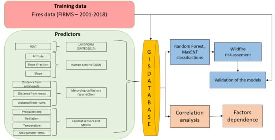
Work was divided into two main stages. The first stage presents the methodology validating the impact of individual fire factors on fire occurrence. The result of the analysis is a determination of dependencies between factors and exclusion from the further classification of factors that do not affect fires. In the second step, based on the literature analysis [
11,
12,
13] two methods of machine learning classifications were implemented to determine the risk of fire: MaxENT and random forest. The initial materials to define fire risk factors were satellite images and their products of various spatial and spectral resolution (Landsat TM, Modis TERRA, GMTED2010, VIIRS), vector data (OSM), and bioclimatic variables (WORLDCLIM).
The results in the form of long-term fire risk maps can be used for fire prevention and planning fire-fighting measures in the territory of the republic. The results can help create an application that can be used to determine the risk of fire and the spread of fire during a disaster. This work has the potential to lay the foundations for the future of a fully automated application of fire risk assessment in the Sakha Republic.
4. Discussion
In fire studies, fire risk is one of the major topics and there are many different approaches to this subject. Blanchi et al., in their work about a methodological approach in fire risk studies, collected more than 50 works connected with fire probability cartography. Risk mapping has less than twenty years. Previously, there were rather preferred descriptive approaches. Since the 1990s, there has been an increasing interest in this field [
36].
The study presented the possibilities of using different types of GIS and remote sensing data in modeling the wildfire risk. Results allow us to reflect various aspects of fire studies. The difficulties in fire risk assessment were to point out and clarify possibilities to define wildfire risk. There are many different approaches in hazard mapping based on different datasets, scales, and algorithms. The multi-approach is relevant in fire management studies [
37,
38]. Gai et al. [
39] developed a spatially weighted index model for fire risk assessment. You et al. [
40] integrated a Forest Resource Inventory Database based on four aspects of topographical, human activity, climate, and forest characteristic factors. Goldarag et al. [
41] used neural networks and logistic regression for fire risk assessment. The biggest challenge in the study was to collect the necessary data due to poor exploration of the area of studies. GIS technologies in Yakutia are under development [
42]. For this purpose, we chose a semi-probabilistic mode of modeling, which gave possibilities of combining historical fire data and physical fire mechanisms [
43].
The results of the analysis showed that the fire risk assessment in the Republic of Sakha (Yakutia) is not a problem that can be easily solved. The specificity of the studied territory is significantly different from other parts of the world that are facing the problem of wildfires. Boreal forests of Yakutia are perfectly adapted to extremely severe climatic conditions. Fires have been affecting the natural functioning of the forests of the region for centuries. Fires not only affect the climatic conditions, but also the formation of the terrain [
36].
Results of the correlation analysis in macroscale showed that with increasing radiation, the risk of fires increases, and the same happened with increasing maximum summer temperature. Lim et al., in their study, highlighted that fire data showed a high correlation with climate factors [
44]. NDVI was highly correlated with fires (R = 0.91). With increasing NDVI, the number of points of ignition increased. This situation was associated with the accumulation of combustible materials along with an increase in forest biomass. Elevation and slope correlated inversely proportional. According to Pourghasemi et al., slope and aspect are some of the most important factors controlling forest fire occurrence [
45]. Kurbatsky et al. wrote that long drought conditions in the Yakutian valleys caused intense droughts and accumulation of fire fuels, which caused strong fires [
46]. As the slope increased, we observed a decreasing number of wildfires. This situation may be due to the strongly inclined slopes that act as a barrier to the spread of fire. Additionally, on inclined slopes, many combustible materials cannot accumulate. Ghorbanzadeh et al. claimed that environmental variables are not the only reason for fire susceptibility and risk [
47]. A very strong connection between the increase in the number of fire points and the human factors was observed. In places with proximity to transport routes, the number of fires increases, and the same thing happens if we consider the settlements. This situation indicates a strong anthropogenic impact on the risk of fire. There are not so many fires near water lines, which can be caused by the presence of moist areas close to the rivers.
The largest correlation at the microscale was observed when taking rainfall into account. As the rainfall increased, the number of fires increased. The other climatic factors did not show a strong correlation. NDVI, similar to the macroscale, strongly influences the number of fires. The properties of combustible materials relate to type, phytomass, condition, and moisture, among which the moisture content is the most important for fire protection [
48]. In a completely different way, anthropogenic factors were distributed on the microscale than on the macroscale. The Nyurbinsky region has a relatively high population density compared to the entire territory of Yakutia, which may affect the differences between the results. Most fires continue to occur along roads, but the closer the settlements are, it occurs less frequently. This situation may be because fires that approach the villages pose a threat to people and fire-fighting starts quickly (fires do not reach large sizes), while those that are far from populated areas remain without any action as they do not pose a great threat. Along roads that are far from villages, fires can reach serious sizes. Additionally, villages in this region are usually not surrounded by forests, but by meadows called “alas”, with lower susceptibility to ignition.
Human activity has a greater influence on the fire regimes and differs in the macro- and microscale. The results showed that distance from settlements (R = −0.97, and R = 0.86), distance from rivers (R = 0.91, and R = −0.54), and distance from roads (R = −0.80, and R = −0.82) had a great importance in fire risk assessment. Ajin et al. [
49] showed a high correlation between fire occurrence and distance from roads and settlements. The study by Werf showed that in residential areas and near roads, more human activities are witnessed, and human activity is the most significant factor in the fire outbreak [
50]. Studies of the territory of Yakutia in residential areas and near roads show that more human activities are witnessed, and the human activity is the most significant factor in fire outbreaks.
Very large differences were observed between the results of the research on the macro- and microscale. Often the results were quite the opposite. It is probably related to the specificity of the Yakutia region. The Niyurbinsky region is quite highly urbanized compared to other regions of Yakutia, which may affect the results. Additionally, the regional climatic conditions differed from the average for the entire region. The Nyuribnsky region is characterized by flat terrain, and most of Yakutia is mountainous, which can also affect the conditions for fires. To analyze the macroscale, it is necessary to take into account a wide variety of conditions: climatic, geographical, and human influence. However, on a microscale, these conditions are more homogeneous.
The analysis of the different methods of wildfire risk assessment allows for the identification of the high danger areas in Nyurbinsky and the entire Yakutia. The maximum accuracy was demonstrated by the random forest method with 11 predictors (R = 0.98) for the entire territory of Yakutia. The analysis showed that the random forest method gave more accurate results and a much narrower area of the possibility of fires than the MaxENT method, which allows us to propose that this model is preferable. A model created using the maximum entropy method has a small differentiation into zones, which does not allow for its use in practice as uninformative. Parisien used the MaxENT and random forest model to predict fire ignition across the USA [
30] with satisfactory results. The MaxENT model was used to assess fire risk in India’s Ghats Mountains [
34]. In their studies, the authors showed a good correlation between the risk models obtained when using machine learning and forest fires. Due to their power, versatility, and ease of use, random forests are quickly becoming one of the most popular machine learning methods [
48]. The studies confirmed that the use of GIS and remote sensing technologies can be used to assess the long-term risk and probability of fires in Yakutia. The results showed that reducing the number of factors during modeling did not show a significant impact on the results in both methods. In the few last years, an increase in the number and severity of fires has been observed as has more years with extreme fire seasons [
9]. This situation may also be affected by climate change. On the other hand, a larger number of fires may have an impact on the climate, permafrost ecosystems, and the functioning of indigenous people. In connection with this situation, it is necessary to work on new fire risk assessment methods in the Arctic and subarctic zone of Yakutia. Methods should use global databases of fire, climate, and human activities. For building new models that include all these factors, it is necessary to use different types of datasets, like OSM data, climatic datasets, and remote sensing data from different sensors (MODIS, Landsat, Sentinel). According to Gigović et al., the random forest model could be used at the regional level for forest fire susceptibility mapping [
51]. Banerjee et al. claim that the MaxENT method can be used as a decision support tool for stakeholders of forest resources [
52]. Pham et al. claim that models that consider climate variables, vegetation, and human influences can explain fire risk better than those that only account for some of these factors [
53].
The objective of work on modeling long-term wildfire risk in the Nyurbinsky region of Yakutia was accomplished. The accuracy of the results depends on the data used, and here available. The results were valid within the limits caused by the data used; the approach was chosen as was the research objective. Despite these limitations, it was possible to obtain interesting results that enabled us to answer the main questions posed by the problem.
5. Conclusions
The problem of the forest fires in Yakutia is not as well studied as in other countries. The results of the research have shown a strong human influence on the risk in this region despite the low population density. Anthropogenic factors showed a high correlation with the occurrence of wildfires more than climatic or topographical factors. Other factors affect the risk of fires at the macroscale, and others the microscale, which should be considered when modeling.
The random forest method showed better results in the macroscale, however, the maximum entropy model was better in the microscale. The exclusion of variables that do not show high correlation does not always improve the modeling results. The random forest presence prediction model is a more accurate method and significantly reduces the risk territory. The reverse is the method of maximum entropy, which is not as accurate and classifies very large areas as endangered.
Further study of this topic requires a clearer and conceptually developed approach to the application of remote sensing data. Therefore, this work makes sense to lay the foundations for the future of a completely automated fire risk assessment application in the Republic of Sakha. The results can be used for fire prophylactics and planning fire prevention. In the future, to determine the risk well, it is necessary to combine the obtained maps with the seasonal risk determined using indices (for example, the Nesterov index 1949) and the periodic dynamics of forest fires, which Isaev and Utkin studied in 1963. Such actions can help build an application with which it will be possible to determine the risk of wildfire and the spreading of fire during extreme events.


