Confidence Levels, Sensitivity, and the Role of Bathymetry in Coral Reef Remote Sensing


Abstract
:
1. Introduction
2. Materials and Methods
2.1. Study Areas
- Kaneohe Bay, a partially enclosed ~50 km2 embayment on the northeast coast of Oahu, contains a central barrier reef, fringing reefs, an extensive lagoon/bay area with numerous patch reefs, and a seaward fore reef. Depths in this area range from <1 m on the reef flats to an average of 10–15 m in the lagoon, with rapidly increasing depth offshore. Water clarity, which impacts the ability to derive bathymetry and benthic information using remote sensing, is typically highest in the northern and more exposed seaward portions of the bay, and lowest along the shore, in the enclosed southern portion of the bay, and following significant rainfall-runoff events.
- The south coast of Molokai, specifically a ~20 km2 section of coastal area immediately adjacent to Kaunakakai Harbor, consists of a 1–2 km wide fringing reef, with a well-defined reef crest, shallow shoreward reef flat, and seaward fore reef. Depths are <1–2 m across the reef flat out to the reef crest, transitioning to 30–50 m within 0.5 km seaward of the reef crest, and then deepening quickly offshore. With the exceptions of portions of the harbor itself, where water residence time is higher, and following rainfall-runoff events, the majority of this area is regulated by adjacent oceanic water conditions and water clarity is generally high.
- French Frigate Shoals, specifically a ~100 km2 subset in the southeast corner of this rather sizeable 900 km2 coral atoll in the remote Northwestern Hawaiian Islands, consists of a lengthy ~35 km crescent shaped reef and reef flats, a semi-enclosed lagoon, a scattering of small islands, and an extensive seaward fore reef. Depths are <1 m at the reef crest, 5–10 m in the eastern and northern portions of the lagoon, transitioning to 15–20 m in the center of the lagoon and 25–30 m in the open western area of the lagoon, and rapidly deepening along the fore reef and offshore. While water clarity along the reef flat and seaward fore reef is regulated by relatively clear oceanic water, areas inside the lagoon, particularly along its protected eastern end, where sediment suspension is generally greater, have higher turbidity and reduced water clarity.
2.2. Remote Sensing Data
2.2.1. Airborne Hyperspectral Data
2.2.2. Lidar Bathymetry Data
2.3. Hyperspectral Data Preprocessing
2.3.1. Geocorrection
2.3.2. Atmospheric Correction
2.3.3. Spatial Resampling
2.3.4. Masking
2.3.5. Sunglint Correction
2.4. Lidar Data Preprocessing
2.4.1. Rasterization
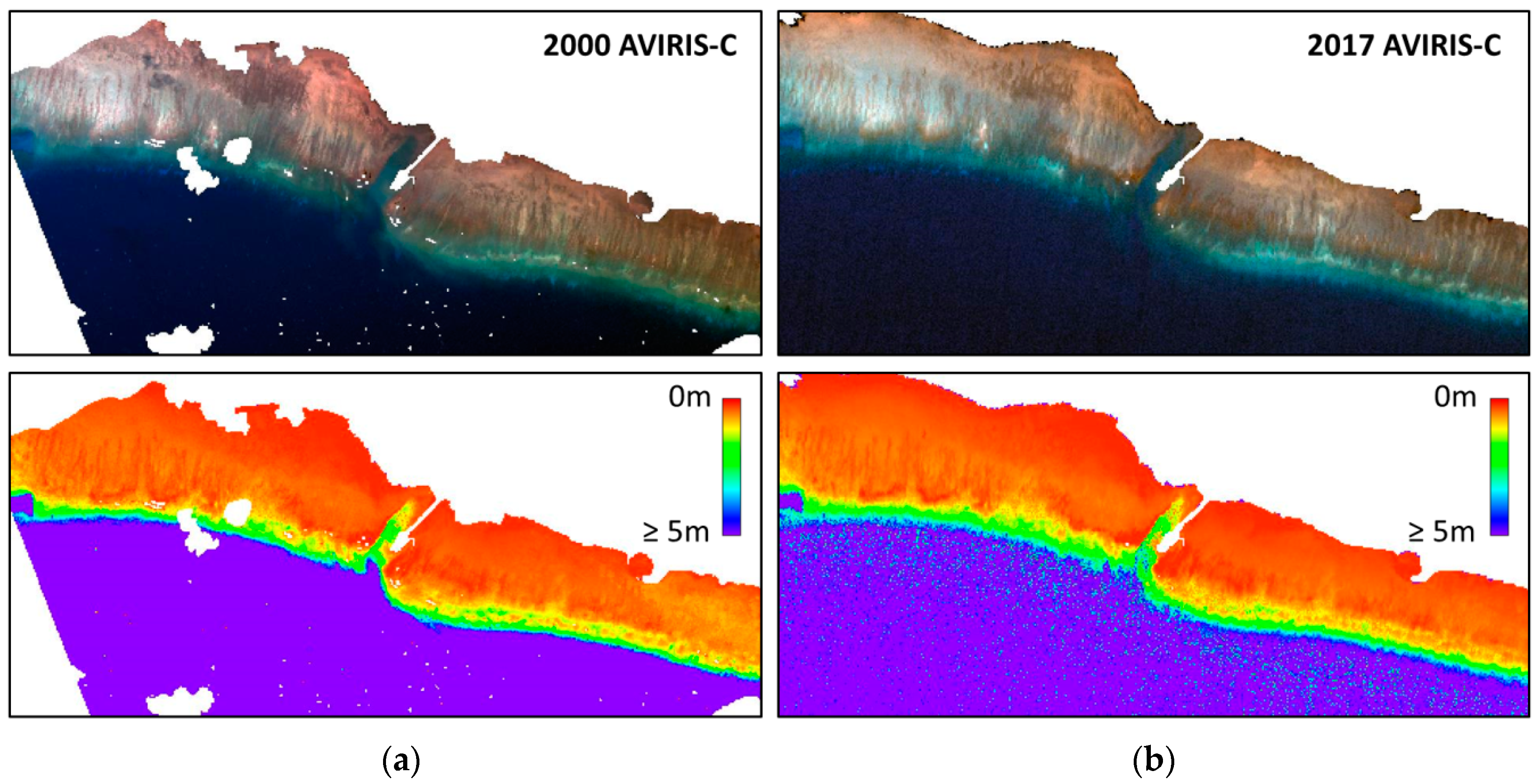
2.4.2. Temporal Comparison
2.5. Hyperspectral Data Analysis
2.5.1. Inversion Model
2.5.2. Lidar Validation
2.5.3. Temporal Validation
2.5.4. Confidence Levels
2.5.5. Sensitivity Analysis
3. Results
3.1. Inversion Model Output
3.2. Lidar Validation
3.3. Temporal Validation
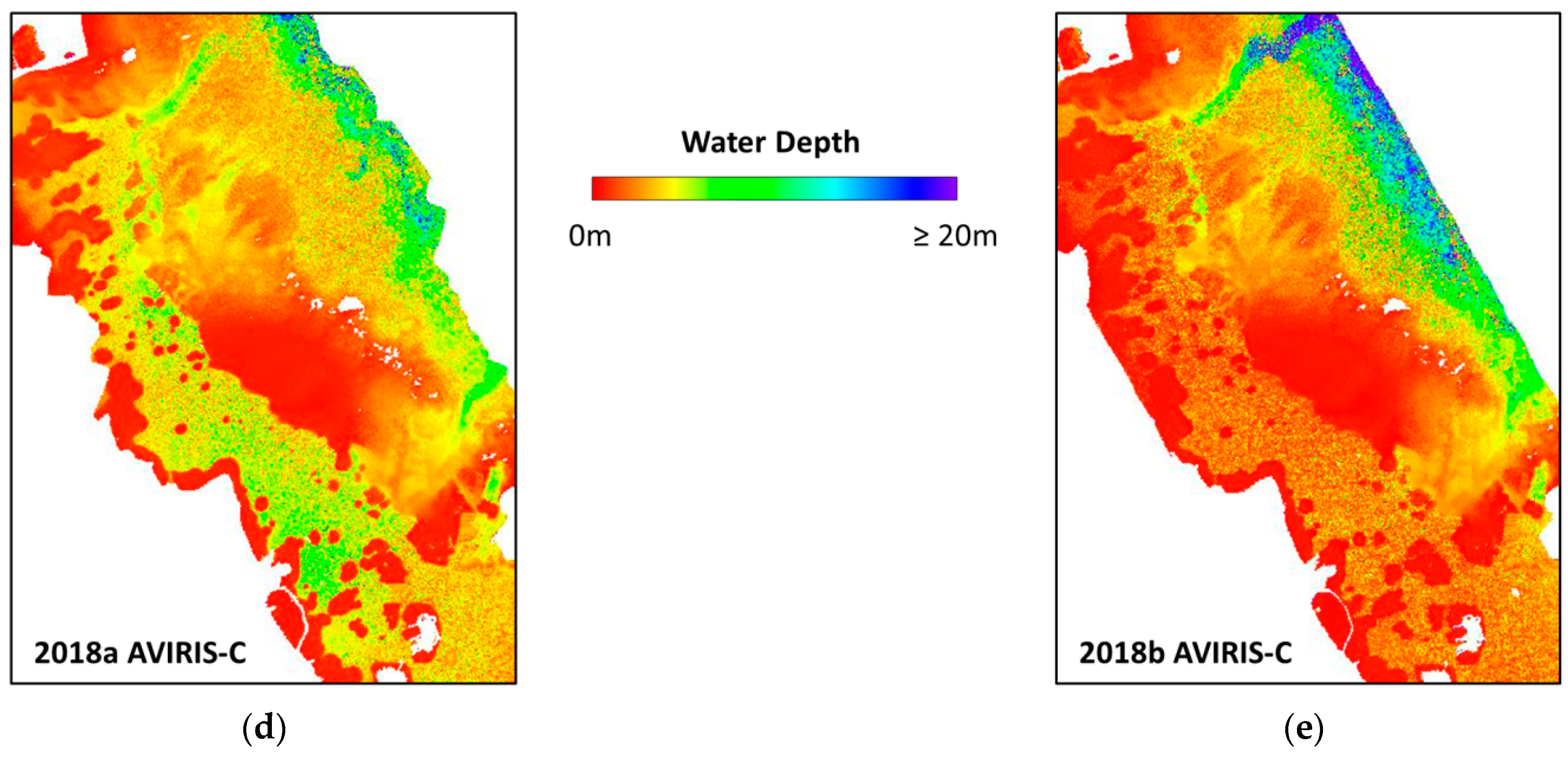
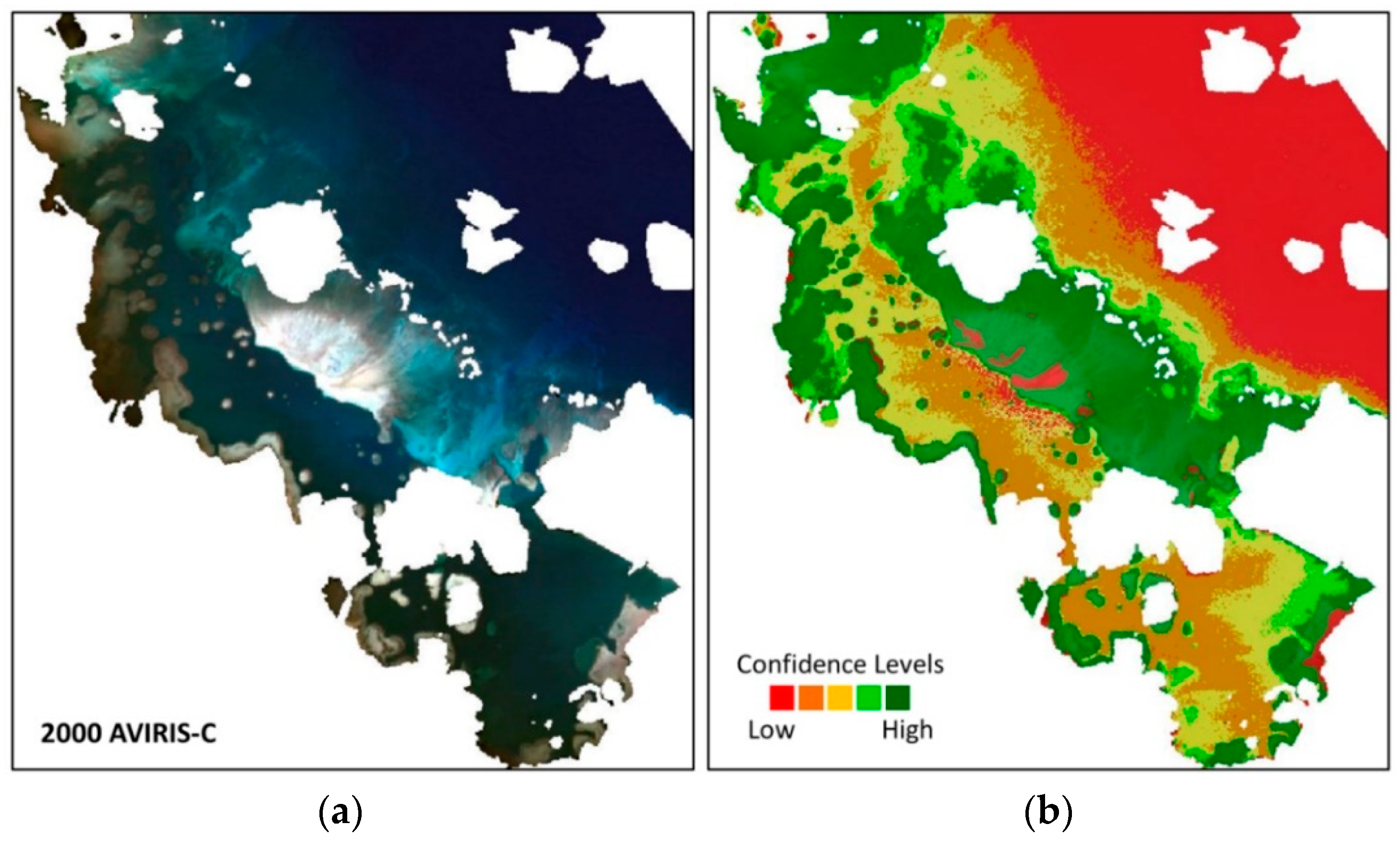
3.4. Confidence Levels
3.5. Sensitivity Analysis
4. Discussion
4.1. Workflow Analysis
4.2. Bathymetry Analysis
5. Conclusions
Author Contributions
Funding
Acknowledgments
Conflicts of Interest
References
- Polcyn, F.C.; Sattinger, I.J. Water depth determinations using remote sensing techniques. In Proceedings of the 6th International Symposium on Remote Sensing of Environment, Ann Arbor, MI, USA, 13–16 October 1969; p. 1017. [Google Scholar]
- Brown, W.L.; Polcyn, F.C.; Stewart, S.R. A method for calculating water depth attenuation coefficients and bottom reflectance characteristics. In Proceedings of the 7th International Symposium on Remote Sensing of Environment, Ann Arbor, MI, USA, 17–21 May 1971; pp. 663–682. [Google Scholar]
- Green, E.P.; Mumby, P.J.; Edwards, A.J.; Clark, C.D. A review of remote sensing for the assessment and management of tropical coastal resources. Coast. Manag. 1996, 24, 1–40. [Google Scholar] [CrossRef]
- Lyzenga, D.R. Passive remote sensing techniques for mapping water depth and bottom features. Appl. Opt. 1978, 17, 379. [Google Scholar] [CrossRef] [PubMed]
- Stumpf, R.P.; Holderied, K.; Sinclair, M. Determination of water depth with high-resolution satellite imagery over variable bottom types. Limnol. Oceanogr. 2003, 48, 547–556. [Google Scholar] [CrossRef]
- Jupp, D.L.B. Background and extensions to depth of penetration (DOP) mapping in shallow coastal waters. In Proceedings of the Symposium on Remote Sensing of the Coastal Zone, Gold Coast, Australia, 7–9 September 1988. [Google Scholar]
- Mumby, P.J.; Skirving, W.; Strong, A.E.; Hardy, J.T.; LeDrew, E.F.; Hochberg, E.J.; Stumpf, R.P.; David, L.T. Remote sensing of coral reefs and their physical environment. Mar. Pollut. Bull. 2004, 48, 219–228. [Google Scholar] [CrossRef]
- Lyzenga, D.R.; Malinas, N.P.; Tanis, F.J. Multispectral bathymetry using a simple physically based algorithm. IEEE Trans. Geosci. Remote Sens. 2006, 44, 2251–2259. [Google Scholar] [CrossRef]
- Danaher, T.J.; Smith, P. Applications of shallow water mapping using passive remote sensing. In Proceedings of the Symposium on Remote Sensing of the Coastal Zone, Gold Coast, Australia, 7–9 September 1988. [Google Scholar]
- Costa, B.M.; Battista, T.A.; Pittman, S.J. Comparative evaluation of airborne LiDAR and ship-based multibeam SoNAR bathymetry and intensity for mapping coral reef ecosystems. Remote Sens. Environ. 2009, 113, 1082–1100. [Google Scholar] [CrossRef]
- Pittman, S.J.; Costa, B.; Wedding, L.M. LiDAR applications. In Coral Reef Remote Sensing; Goodman, J.A., Purkis, S.J., Phinn, S.R., Eds.; Springer: Dordrecht, The Netherlands, 2013; pp. 145–174. [Google Scholar] [CrossRef]
- Abbot, R.H.; Lane, D.W.; Sinclair, M.J.; Spurling, T.A. Lasers chart the waters of Australia’s Great Barrier Reef. In Proceedings of the CIS Selected Papers: Laser Remote Sensing of Natural Waters: From Theory to Practice, St. Petersburg, Russia, 13 November 1996; SPIE: Bellingham, WA, USA, 1996; Volume 2964, pp. 72–90. [Google Scholar] [CrossRef]
- Wang, C.K.; Philpot, W.D. Using airborne bathymetric lidar to detect bottom type variation in shallow waters. Remote Sens. Environ. 2007, 106, 123–135. [Google Scholar] [CrossRef]
- Gao, J. Bathymetric mapping by means of remote sensing: Methods, accuracy and limitations. Prog. Phys. Geogr. 2009, 33, 103–116. [Google Scholar] [CrossRef]
- Brando, V.E.; Anstee, J.M.; Wettle, M.; Dekker, A.G.; Phinn, S.R.; Roelfsema, C. A physics based retrieval and quality assessment of bathymetry from suboptimal hyperspectral data. Remote Sens. Environ. 2009, 113, 755–770. [Google Scholar] [CrossRef]
- Purkis, S.; Kerr, J.; Dempsey, A.; Calhoun, A.; Metsamaa, L.; Riegl, B.; Kourafalou, V.; Bruckner, A.; Renaud, P. Large-scale carbonate platform development of Cay Sal Bank, Bahamas, and implications for associated reef geomorphology. Geomorphology 2014, 222, 25–38. [Google Scholar] [CrossRef]
- Liceaga-Correa, M.A.; Euan-Avila, J.I. Assessment of coral reef bathymetric mapping using visible Landsat Thematic Mapper data. Int. J. Remote Sens. 2002, 23, 3–14. [Google Scholar] [CrossRef]
- Hedley, J.D.; Roelfsema, C.M.; Chollett, I.; Harborne, A.R.; Heron, S.F.; Weeks, S.J.; Skirving, W.J.; Strong, A.E.; Mark Eakin, C.; Christensen, T.R.L.; et al. Remote sensing of coral reefs for monitoring and management: A review. Remote Sens. 2016, 8, 118. [Google Scholar] [CrossRef] [Green Version]
- Asner, G.P.; Martin, R.E.; Mascaro, J. Coral reef atoll assessment in the South China Sea using Planet Dove satellites. Remote Sens. Ecol. Conserv. 2017, 3, 57–65. [Google Scholar] [CrossRef]
- Parsons, M.; Bratanov, D.; Gaston, K.J.; Gonzalez, F. UAVs, hyperspectral remote sensing, and machine learning revolutionizing reef monitoring. Sensors 2018, 18, 2026. [Google Scholar] [CrossRef] [Green Version]
- Purkis, S.J.; Gleason, A.C.R.; Purkis, C.R.; Dempsey, A.C.; Renaud, P.G.; Faisal, M.; Saul, S.; Kerr, J.M. High-resolution habitat and bathymetry maps for 65,000 sq. km of Earth’s remotest coral reefs. Coral Reefs 2019, 38, 467–488. [Google Scholar] [CrossRef] [Green Version]
- World Reef Map. Available online: https://maps.lof.org/lof (accessed on 10 October 2019).
- Allen Coral Atlas. Available online: https://allencoralatlas.org/ (accessed on 10 October 2019).
- Andréfouët, S.; Muller-Karger, F.E.; Robinson, J.A.; Kranenburg, C.J.; Torres-Pulliza, D.; Spraggins, S.A.; Murch, B. Global assessment of modern coral reef extent and diversity for regional science and management applications: A view from space. In Proceedings of the 10th International Coral Reef Symposium, Okinawa, Japan, 28 June–2 July; Japanese Coral Reef Society: Okinawa, Japan, 2006; pp. 1732–1745. [Google Scholar]
- Lucas, M.Q.; Goodman, J. Linking coral reef remote sensing and field ecology: It’s a matter of scale. J. Mar. Sci. Eng. 2015, 3, 1–20. [Google Scholar] [CrossRef]
- Andréfouët, S. Coral reef habitat mapping using remote sensing: A user vs producer perspective. Implications for research, management and capacity building. J. Spat. Sci. 2008, 53, 113–129. [Google Scholar] [CrossRef]
- Andréfouët, S.; Guillaume, M.M.M.; Delval, A.; Rasoamanendrika, F.M.A.; Blanchot, J.; Bruggemann, J.H. Fifty years of changes in reef flat habitats of the Grand Récif of Toliara (SW Madagascar) and the impact of gleaning. Coral Reefs 2013, 32, 757–768. [Google Scholar] [CrossRef]
- Ampou, E.E.; Ouillon, S.; Iovan, C.; Andréfouët, S. Change detection of Bunaken Island coral reefs using 15 years of very high resolution satellite images: A kaleidoscope of habitat trajectories. Mar. Pollut. Bull. 2018, 131, 83–95. [Google Scholar] [CrossRef]
- Knudby, A.; Roelfsema, C.; Lyons, M.; Phinn, S.; Jupiter, S. Mapping fish community variables by Integrating field and satellite data, object-based image analysis and modeling in a traditional Fijian fisheries management area. Remote Sens. 2011, 3, 460–483. [Google Scholar] [CrossRef] [Green Version]
- Zhang, C.; Selch, D.; Xie, Z.; Roberts, C.; Cooper, H.; Chen, G. Object-based benthic habitat mapping in the Florida Keys from hyperspectral imagery. Estuar. Coast. Shelf Sci. 2013, 134, 88–97. [Google Scholar] [CrossRef]
- Li, J.; Schill, S.R.; Knapp, D.E.; Asner, G.P. Object-based mapping of coral reef habitats using planet dove satellites. Remote Sens. 2019, 11, 1445. [Google Scholar] [CrossRef] [Green Version]
- Zhang, C. Applying data fusion techniques for benthic habitat mapping and monitoring in a coral reef ecosystem. ISPRS J. Photogramm. Remote Sens. 2015, 104, 213–223. [Google Scholar] [CrossRef]
- Saul, S.; Purkis, S. Semi-automated object-based classification of coral reef habitat using discrete choice models. Remote Sens. 2015, 7, 15894–15916. [Google Scholar] [CrossRef] [Green Version]
- Misra, A.; Vojinovic, Z.; Ramakrishnan, B.; Luijendijk, A.; Ranasinghe, R. Shallow water bathymetry mapping using Support Vector Machine (SVM) technique and multispectral imagery. Int. J. Remote Sens. 2018, 39, 4431–4450. [Google Scholar] [CrossRef]
- Traganos, D.; Poursanidis, D.; Aggarwal, B.; Chrysoulakis, N.; Reinartz, P. Estimating satellite-derived bathymetry (SDB) with the Google Earth Engine and sentinel-2. Remote Sens. 2018, 10, 859. [Google Scholar] [CrossRef] [Green Version]
- Mobley, C.D.; Sundman, L.K.; Davis, C.O.; Bowles, J.H.; Downes, T.V.; Leathers, R.A.; Montes, M.J.; Bissett, W.P.; Kohler, D.D.R.; Reid, R.P.; et al. Interpretation of hyperspectral remote-sensing imagery by spectrum matching and look-up tables. Appl. Opt. 2005, 44, 3576–3592. [Google Scholar] [CrossRef]
- Klonowski, W.M. Retrieving key benthic cover types and bathymetry from hyperspectral imagery. J. Appl. Remote Sens. 2007, 1, 011505. [Google Scholar] [CrossRef]
- Dekker, A.G.; Phinn, S.R.; Anstee, J.; Bissett, P.; Brando, V.E.; Casey, B.; Fearns, P.; Hedley, J.; Klonowski, W.; Lee, Z.P.; et al. Intercomparison of shallow water bathymetry, hydro-optics, and benthos mapping techniques in Australian and Caribbean coastal environments. Limnol. Oceanogr. Methods 2011, 9, 396–425. [Google Scholar] [CrossRef] [Green Version]
- Garcia, R.A.; Lee, Z.; Hochberg, E.J. Hyperspectral shallow-water remote sensing with an enhanced benthic classifier. Remote Sens. 2018, 10, 147. [Google Scholar] [CrossRef] [Green Version]
- Hedley, J.; Roelfsema, C.; Phinn, S.R. Efficient radiative transfer model inversion for remote sensing applications. Remote Sens. Environ. 2009, 113, 2527–2532. [Google Scholar] [CrossRef]
- Irish, J.L.; McClung, J.K.; Lillycrop, W.J. Airborne lidar bathymetry: The SHOALS system. Bull. Int. Navig. Assoc. 2000, 103, 43–54. [Google Scholar] [CrossRef]
- Pope, R.W.; Reed, B.A.; West, G.W.; Lillycrop, W.J. Use of an airborne laser depth sounding system in a complex shallow-water environment. In Proceedings of the XVth Hydrographic Symposium and International HydroConference, Monaco, 21–22 April 1997. [Google Scholar]
- Riley, J.L. Evaluating SHOALS bathymetry using NOAA Hydrographic Survey data. In Proceedings of the 24th Joint Meeting of UJNR Sea-Bottom Surveys Panel, Tokyo, Japan, 13–17 November 1995. [Google Scholar]
- Wozencraft, J.M.; Jeff Lillycrop, W. SHOALS airborne coastal mapping: Past, present, and future. J. Coast. Res. 2003, 207–215. [Google Scholar]
- OCM Partners. 2000 USACE Bathymetric LiDAR: Hawaiian Islands. NOAA National Centers for Environmental Information. Available online: https://inport.nmfs.noaa.gov/inport/item/49740 (accessed on 12 November 2018).
- Tuell, G.; Barbor, K.; Wozencraft, J. Overview of the coastal zone mapping and imaging lidar (CZMIL): A new multisensor airborne mapping system for the U.S. Army Corps of Engineers. In Proceedings of the SPIE Defence, Security, and Sensing, Algorithms and Technologies for Multispectral, Hyperspectral, and Ultraspectral Imagery XVI, Orlando, FL, USA, 12 May 2010; Shen, S.S., Lewis, P.E., Eds.; SPIE: Bellingham, WA, USA, 2010; Volume 7695, p. 76950R. [Google Scholar] [CrossRef]
- Feygels, V.I.; Park, J.Y.; Wozencraft, J.; Aitken, J.; Macon, C.; Mathur, A.; Payment, A.; Ramnath, V. CZMIL (coastal zone mapping and imaging lidar): From first flights to first mission through system validation. In Proceedings of the SPIE Defense, Security, and Sensing, Ocean Sensing and Monitoring V, Baltimore, MD, USA, 3 June 2013; Hou, W.W., Arnone, R.A., Eds.; SPIE: Bellingham, WA, USA, 2013; Volume 8724, p. 87240A. [Google Scholar] [CrossRef]
- OCM Partners. 2013 USACE NCMP Topobathy Lidar: Oahu (HI). NOAA National Centers for Environmental Information. Available online: https://inport.nmfs.noaa.gov/inport/item/49756 (accessed on 29 November 2018).
- OCM Partners. 2013 USACE NCMP Topobathy Lidar: Molokai (HI). NOAA National Centers for Environmental Information. Available online: https://inport.nmfs.noaa.gov/inport/item/49753 (accessed on 29 November 2018).
- Boardman, J. Precision geocoding of low altitude AVIRIS data: Lessons learned in 1998. In Proceedings of the Summaries of the Eighth JPL Airborne Earth Science Workshop, Pasadena, CA, USA, 9–11 February 1999; pp. 63–68. [Google Scholar]
- Chapman, J.W.; Thompson, D.R.; Helmlinger, M.C.; Bue, B.D.; Green, R.O.; Eastwood, M.L.; Geier, S.; Olson-Duvall, W.; Lundeen, S.R. Spectral and rediometric calibration of the Next Generation Airborne Visible Infrared Spectrometer (AVIRIS-NG). Remote Sens. 2009, 11, 2129. [Google Scholar] [CrossRef] [Green Version]
- Williams, M.D.; Kerekes, J.P.; van Aardt, J. Application of abundance map reference data for spectral unmixing. Remote Sens. 2017, 9, 793. [Google Scholar] [CrossRef] [Green Version]
- Goodman, J.A.; Lee, Z.; Ustin, S.L. Influence of atmospheric and sea-surface corrections on retrieval of bottom depth and reflectance using a semi-analytical model: A case study in Kaneohe Bay, Hawaii. Appl. Opt. 2008, 47, F1–F11. [Google Scholar] [CrossRef] [Green Version]
- Mishra, D.R.; Narumalani, S.; Rundquist, D.; Lawson, M.; Perk, R. Enhancing the detection and classification of coral reef and associated benthic habitats: A hyperspectral remote sensing approach. J. Geophys. Res. Ocean. 2007, 112. [Google Scholar] [CrossRef] [Green Version]
- Kobryn, H.T.; Wouters, K.; Beckley, L.E.; Heege, T. Ningaloo Reef: Shallow marine habitats mapped using a hyperspectral sensor. PLoS ONE 2013, 8, e70105. [Google Scholar] [CrossRef] [Green Version]
- Thompson, D.R.; Gao, B.C.; Green, R.O.; Roberts, D.A.; Dennison, P.E.; Lundeen, S.R. Atmospheric correction for global mapping spectroscopy: ATREM advances for the HyspIRI preparatory campaign. Remote Sens. Environ. 2015, 167, 64–77. [Google Scholar] [CrossRef]
- Gao, B.C.; Heidebrecht, K.B.; Goetz, A.F.H. Derivation of scaled surface reflectances from AVIRIS data. Remote Sens. Environ. 1993, 44, 165–178. [Google Scholar] [CrossRef]
- Olson-Duvall, W.; Jet Propulsion Laboratory, Pasadena, CA, USA. Personal Communication, 2019.
- Goodman, J.A.; Ustin, S.L. Classification of benthic composition in a coral reef environment using spectral unmixing. J. Appl. Remote Sens. 2007, 1, 011501. [Google Scholar] [CrossRef]
- Lee, Z.; Carder, K.L.; Mobley, C.D.; Steward, R.G.; Patch, J.S. Hyperspectral remote sensing for shallow waters I A semianalytical model. Appl. Opt. 1998, 37, 6329. [Google Scholar] [CrossRef] [PubMed]
- Lee, Z.; Carder, K.L.; Mobley, C.D.; Steward, R.G.; Patch, J.S. Hyperspectral remote sensing for shallow waters: 2 Deriving bottom depths and water properties by optimization. Appl. Opt. 1999, 38, 3831. [Google Scholar] [CrossRef] [PubMed] [Green Version]
- Hansen, M.C.; Potapov, P.V.; Moore, R.; Hancher, M.; Turubanova, S.A.; Tyukavina, A.; Thau, D.; Stehman, S.V.; Goetz, S.J.; Loveland, T.R.; et al. High-resolution global maps of 21st-century forest cover change. Science 2013, 342, 850–853. [Google Scholar] [CrossRef] [Green Version]
- Koju, U.A.; Zhang, J.; Maharjan, S.; Zhang, S.; Bai, Y.; Vijayakumar, D.B.I.P.; Yao, F. A two-scale approach for estimating forest aboveground biomass with optical remote sensing images in a subtropical forest of Nepal. J. For. Res. 2019, 30, 2119–2136. [Google Scholar] [CrossRef]
- Giardino, C.; Candiani, G.; Bresciani, M.; Lee, Z.; Gagliano, S.; Pepe, M. BOMBER: A tool for estimating water quality and bottom properties from remote sensing images. Comput. Geosci. 2012, 45, 313–318. [Google Scholar] [CrossRef]
- Jay, S.; Guillaume, M.; Minghelli, A.; Deville, Y.; Chami, M.; Lafrance, B.; Serfaty, V. Hyperspectral remote sensing of shallow waters: Considering environmental noise and bottom intra-class variability for modeling and inversion of water reflectance. Remote Sens. Environ. 2017, 200, 352–367. [Google Scholar] [CrossRef]
- Petit, T.; Bajjouk, T.; Mouquet, P.; Rochette, S.; Vozel, B.; Delacourt, C. Hyperspectral remote sensing of coral reefs by semi-analytical model inversion—Comparison of different inversion setups. Remote Sens. Environ. 2017, 190, 348–365. [Google Scholar] [CrossRef]
- Hochberg, E.J.; Bruce, C.F.; Green, R.O.; Oaida, B.V.; Muller-Karger, F.E.; Mobley, C.D.; Park, Y.; Goodman, J.; Knox, R.G.; Middleton, E.M.; et al. HyspIRI Sun Glint Report; JPL Publication 11-4; National Aeronautics and Space Administration, Jet Propulsion Laboratory: Pasadena, CA, USA, 2011. [Google Scholar]
- Kay, S.; Hedley, J.; Lavender, S. Sun glint correction of high and low spatial resolution images of aquatic scenes: A review of methods for visible and near-infrared wavelengths. Remote Sens. 2009, 1, 697–730. [Google Scholar] [CrossRef] [Green Version]
- Ackerman, S.A.; Strabala, K.I.; Menzel, W.P.; Frey, R.A.; Moeller, C.C.; Gumley, L.E. Discriminating clear sky from clouds with MODIS. J. Geophys. Res. Atmos. 1998, 103, 32141–32157. [Google Scholar] [CrossRef]
- Robinson, W.D.; Franz, B.A.; Patt, F.S.; Bailey, S.W.; Werdell, P.J. Masks and flags updates. In Volume 22, Algorithm Updates for the Fourth SeaWiFS Data Reprocessing; SeaWiFS Postlaunch Technical Report Series, NASA Tech. Memo NASA/TM-2003-206892; NASA Goddard Space Flight Center: Greenbelt, MD, USA, 2003; Volume 22, pp. 34–40. [Google Scholar]
- Wang, M.; Shi, W. Cloud masking for ocean color data processing in the coastal regions. IEEE Trans. Geosci. Remote Sens. 2006, 44, 3196–3205. [Google Scholar] [CrossRef]
- Zhu, Z.; Woodcock, C.E. Object-based cloud and cloud shadow detection in Landsat imagery. Remote Sens. Environ. 2012, 118, 83–94. [Google Scholar] [CrossRef]
- Kerr, J.M.; Purkis, S. An algorithm for optically-deriving water depth from multispectral imagery in coral reef landscapes in the absence of ground-truth data. Remote Sens. Environ. 2018, 210, 307–324. [Google Scholar] [CrossRef]
- Bajjouk, T.; Mouquet, P.; Ropert, M.; Quod, J.P.; Hoarau, L.; Bigot, L.; Le Dantec, N.; Delacourt, C.; Populus, J. Detection of changes in shallow coral reefs status: Towards a spatial approach using hyperspectral and multispectral data. Ecol. Indic. 2019, 96, 174–191. [Google Scholar] [CrossRef]
- Hamylton, S. A comparison of spatially explicit and classic regression modelling of live coral cover using hyperspectral remote-sensing data in the Al Wajh lagoon. Red Sea Int. J. Geogr. Inf. Sci. 2012, 26, 2161–2175. [Google Scholar] [CrossRef] [Green Version]
- Huang, R.; Yu, K.; Wang, Y.; Wang, J.; Mu, L.; Wang, W. Bathymetry of the coral reefs of Weizhou Island based on multispectral satellite images. Remote Sens. 2017, 9, 750. [Google Scholar] [CrossRef] [Green Version]
- Hamylton, S.; Hedley, J.; Beaman, R. Derivation of high-resolution bathymetry from multispectral satellite imagery: A comparison of empirical and optimisation methods through geographical error analysis. Remote Sens. 2015, 7, 16257–16273. [Google Scholar] [CrossRef] [Green Version]
- Hochberg, E.J.; Atkinson, M.J. Capabilities of remote sensors to classify coral, algae, and sand as pure and mixed spectra. Remote Sens. Environ. 2003, 85, 174–189. [Google Scholar] [CrossRef]


| Area | AVIRIS-C Dataset 1 | Acquisition Date | Spatial Resolution | Tide (MLLW) | Subsurface Solar Zenith Angle |
|---|---|---|---|---|---|
| Kaneohe Bay | f000412t01p03r08 | 12 Apr 2000 | 17 m | 0.100 m | 9.80 deg |
| f170303t01p00r07 | 3 Mar 2017 | 7.3 m | 0.277 m | 39.26 deg | |
| f180129t01p00r07 | 29 Jan 2018a | 7.5 m | 0.542 m | 28.40 deg | |
| f180212t01p00r07 | 12 Feb 2018b | 7.4 m | 0.327 m | 40.51 deg | |
| South Coast Molokai | f011102t01p03r07 | 2 Nov 2001 | 9.1 m | 0.140 m | 27.95 deg |
| f170127t01p00r26 | 27 Jan 2017 | 17 m | 0.110 m | 28.32 deg | |
| f180126t01p00r11 | 26 Jan 2018 | 16.9 m | 0.280 m | 31.48 deg | |
| French Frigate Shoals | f000418t01p03r01 | 18 Apr 2000 | 17 m | – | 9.48 deg |
| f170203t01p00r16 | 3 Feb 2017 | 17 m | – | 30.59 deg |
| Area | Dataset | Year | Spatial Resolution | |||
|---|---|---|---|---|---|---|
| 18 m | 30 m | 60 m | ||||
| Kaneohe Bay | f000412t01p03r08 | 2000 | r | 0.84 | 0.85 | 0.84 |
| m | −1.01 m | −1.08 m | −1.11 m | |||
| f170303t01p00r07 | 2017 | r | 0.75 | 0.75 | 0.74 | |
| m | −0.68 m | −0.85 m | −0.93 | |||
| f180129t01p00r07 | 2018a | r | 0.74 | 0.78 | 0.76 | |
| m | −2.65 m | −2.76 m | −2.80 m | |||
| f180212t01p00r07 | 2018b | r | 0.57 | 0.55 | 0.54 | |
| m | −2.20 m | −2.31 m | −2.38 m | |||
| Molokai | f011102t01p03r07 | 2001 | r | 0.93 | 0.93 | 0.93 |
| m | −0.43 m | −0.45 m | −0.45 m | |||
| f170127t01p00r26 | 2017 | r | 0.94 | 0.96 | 0.97 | |
| m | −0.94 m | −0.93 m | −0.99 m | |||
| f180126t01p00r11 | 2018 | r | 0.79 | 0.85 | 0.86 | |
| m | −1.67 m | −1.72 m | −1.78 m | |||
| Area | Dataset | Year | Acquisition Year | ||||
|---|---|---|---|---|---|---|---|
| 2000/1 | 2017 | 2018a | 2018b | ||||
| Kaneohe Bay | f000412t01p03r08 | 2000 | r m | − | 0.86 0.42 m | 0.71 −1.63 m | 0.74 −1.03 m |
| f170303t01p00r07 | 2017 | r m | 0.86 −0.42 m | − | 0.67 −1.97 m | 0.78 −1.44 m | |
| f180129t01p00r07 | 2018a | r m | 0.71 1.63 m | 0.67 1.97 m | − | 0.55 0.45 m | |
| f180212t01p00r07 | 2018b | r m | 0.74 1.03 m | 0.78 1.44 m | 0.55 −0.45 m | − | |
| Molokai | f011102t01p03r07 | 2001 | r m | − | 0.88 −0.39 m | 0.73 −1.03 m | − |
| f170127t01p00r26 | 2017 | r m | 0.88 0.39 m | − | 0.79 −0.75 m | − | |
| f180126t01p00r11 | 2018 | r m | 0.73 1.03 m | 0.79 0.75 m | − | − | |
| FFS | f000418t01p03r01 | 2000 | r m | − | 0.80 −0.22 m | − | − |
| f170203t01p00r16 | 2017 | r m | 0.80 0.22 m | − | − | − | |
| Area | Dataset | Year | Spatial | Depth Interval | |||
|---|---|---|---|---|---|---|---|
| 0–5 m | 5–10 m | 10–15 m | 15–20 m | ||||
| Kaneohe Bay | f000412t01p03r08 | 2000 | 18 m | 0.218 | 0.219 | 0.244 | 0.276 |
| 30 m | 0.214 | 0.219 | 0.245 | 0.279 | |||
| 60 m | 0.206 | 0.217 | 0.247 | 0.279 | |||
| f170303t01p00r07 | 2017 | 18 m | 0.169 | 0.155 | 0.145 | 0.159 | |
| 30 m | 0.165 | 0.158 | 0.136 | 0.116 | |||
| 60 m | 0.157 | 0.154 | 0.128 | 0.116 | |||
| f180129t01p00r07 | 2018a | 18 m | 0.094 | 0.048 | 0.022 | 0.016 | |
| 30 m | 0.086 | 0.038 | 0.011 | 0.01 | |||
| 60 m | 0.08 | 0.036 | 0.011 | 0.01 | |||
| f180212t01p00r07 | 2018b | 18 m | 0.099 | 0.058 | 0.043 | 0.07 | |
| 30 m | 0.084 | 0.041 | 0.034 | 0.049 | |||
| 60 m | 0.076 | 0.039 | 0.033 | 0.049 | |||
| Molokai | f01110201p03r07 | 2001 | 18 m | 0.065 | 0.121 | 0.083 | 0.066 |
| 30 m | 0.059 | 0.123 | 0.079 | 0.067 | |||
| 60 m | 0.057 | 0.117 | 0.073 | 0.062 | |||
| f170127t01p00r26 | 2017 | 18 m | 0.158 | 0.083 | 0.036 | 0.02 | |
| 30 m | 0.158 | 0.076 | 0.019 | 0.011 | |||
| 60 m | 0.152 | 0.063 | 0.014 | 0.01 | |||
| f180126t01p00r11 | 2018 | 18 m | 0.149 | 0.01 | 0.01 | 0.01 | |
| 30 m | 0.149 | 0.01 | 0.01 | 0.01 | |||
| 60 m | 0.147 | 0.01 | 0.01 | 0.01 | |||
© 2020 by the authors. Licensee MDPI, Basel, Switzerland. This article is an open access article distributed under the terms and conditions of the Creative Commons Attribution (CC BY) license (http://creativecommons.org/licenses/by/4.0/).
Share and Cite
Goodman, J.A.; Lay, M.; Ramirez, L.; Ustin, S.L.; Haverkamp, P.J. Confidence Levels, Sensitivity, and the Role of Bathymetry in Coral Reef Remote Sensing. Remote Sens. 2020, 12, 496. https://doi.org/10.3390/rs12030496
Goodman JA, Lay M, Ramirez L, Ustin SL, Haverkamp PJ. Confidence Levels, Sensitivity, and the Role of Bathymetry in Coral Reef Remote Sensing. Remote Sensing. 2020; 12(3):496. https://doi.org/10.3390/rs12030496
Chicago/Turabian StyleGoodman, James A., Mui Lay, Luis Ramirez, Susan L. Ustin, and Paul J. Haverkamp. 2020. "Confidence Levels, Sensitivity, and the Role of Bathymetry in Coral Reef Remote Sensing" Remote Sensing 12, no. 3: 496. https://doi.org/10.3390/rs12030496
APA StyleGoodman, J. A., Lay, M., Ramirez, L., Ustin, S. L., & Haverkamp, P. J. (2020). Confidence Levels, Sensitivity, and the Role of Bathymetry in Coral Reef Remote Sensing. Remote Sensing, 12(3), 496. https://doi.org/10.3390/rs12030496