Improving Sea Level Anomaly Precision from Satellite Altimetry Using Parameter Correction in the Red Sea
Abstract
:1. Introduction
2. Materials and Methods
2.1. Data
2.2. Methods
3. Result and Discussion
3.1. Ionospheric Correction
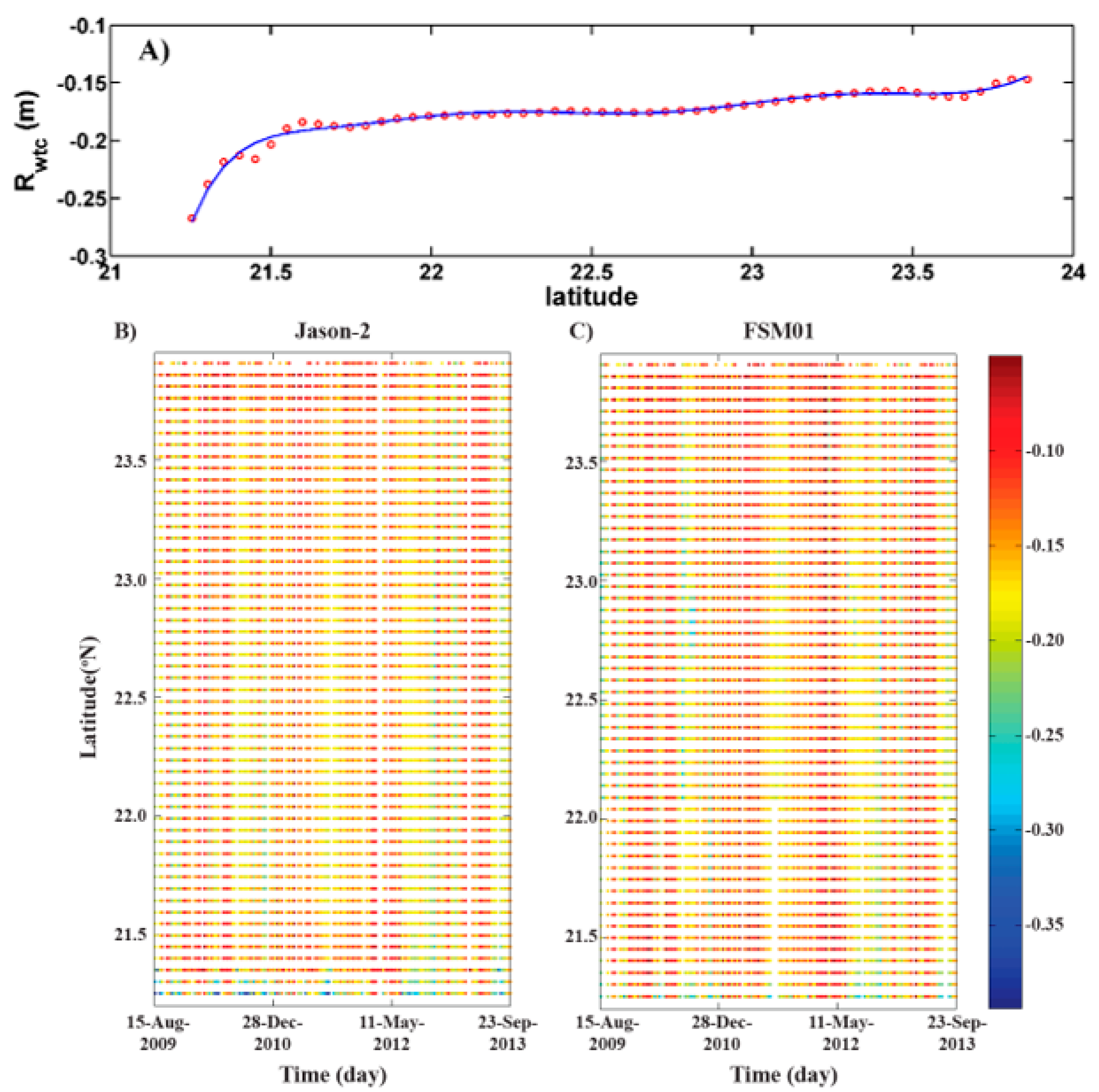
3.2. Wet Tropospheric Correction
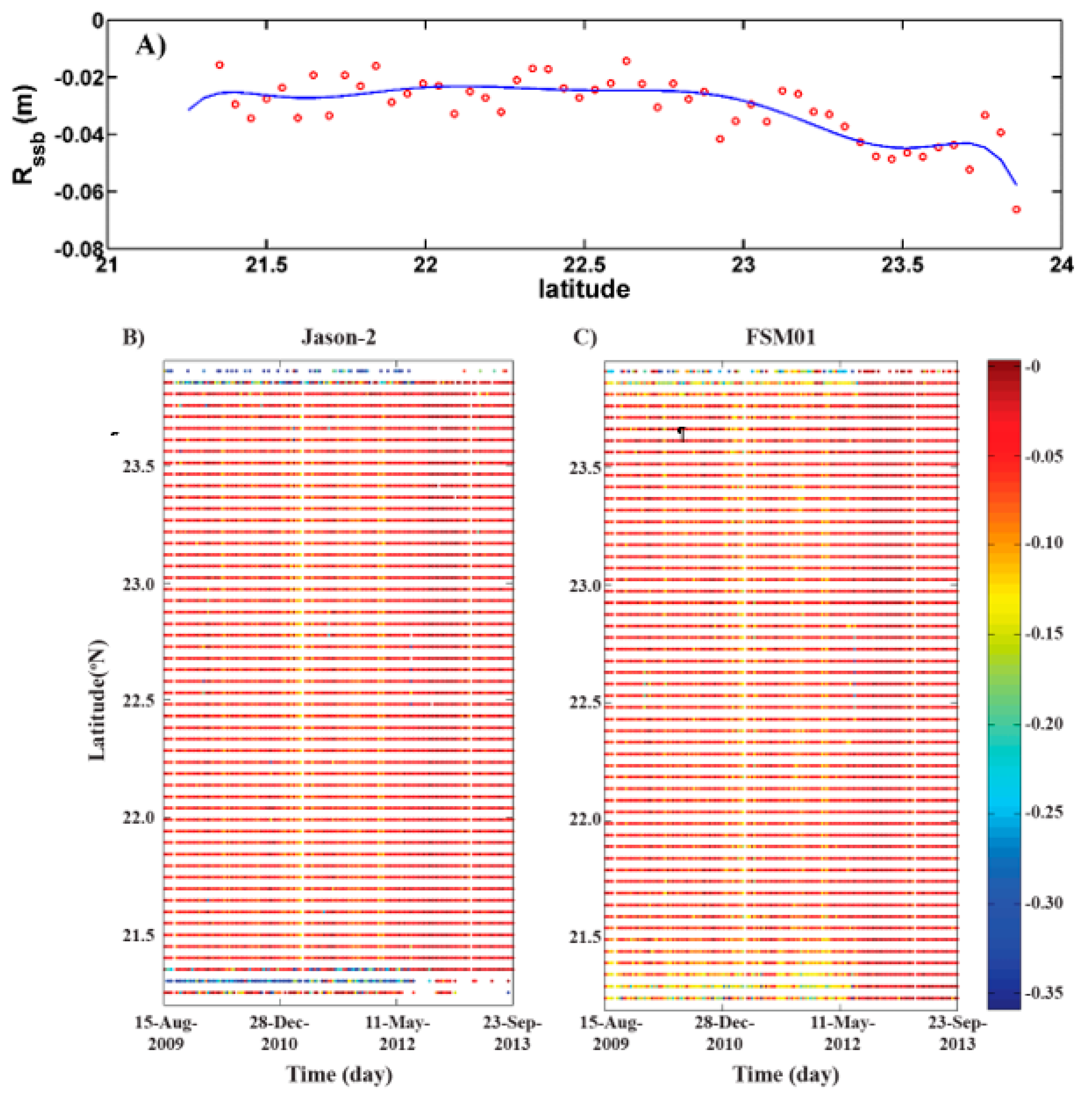
3.3. Sea State Bias Correction
3.4. Dry Tropospheric Correction (Rdry)
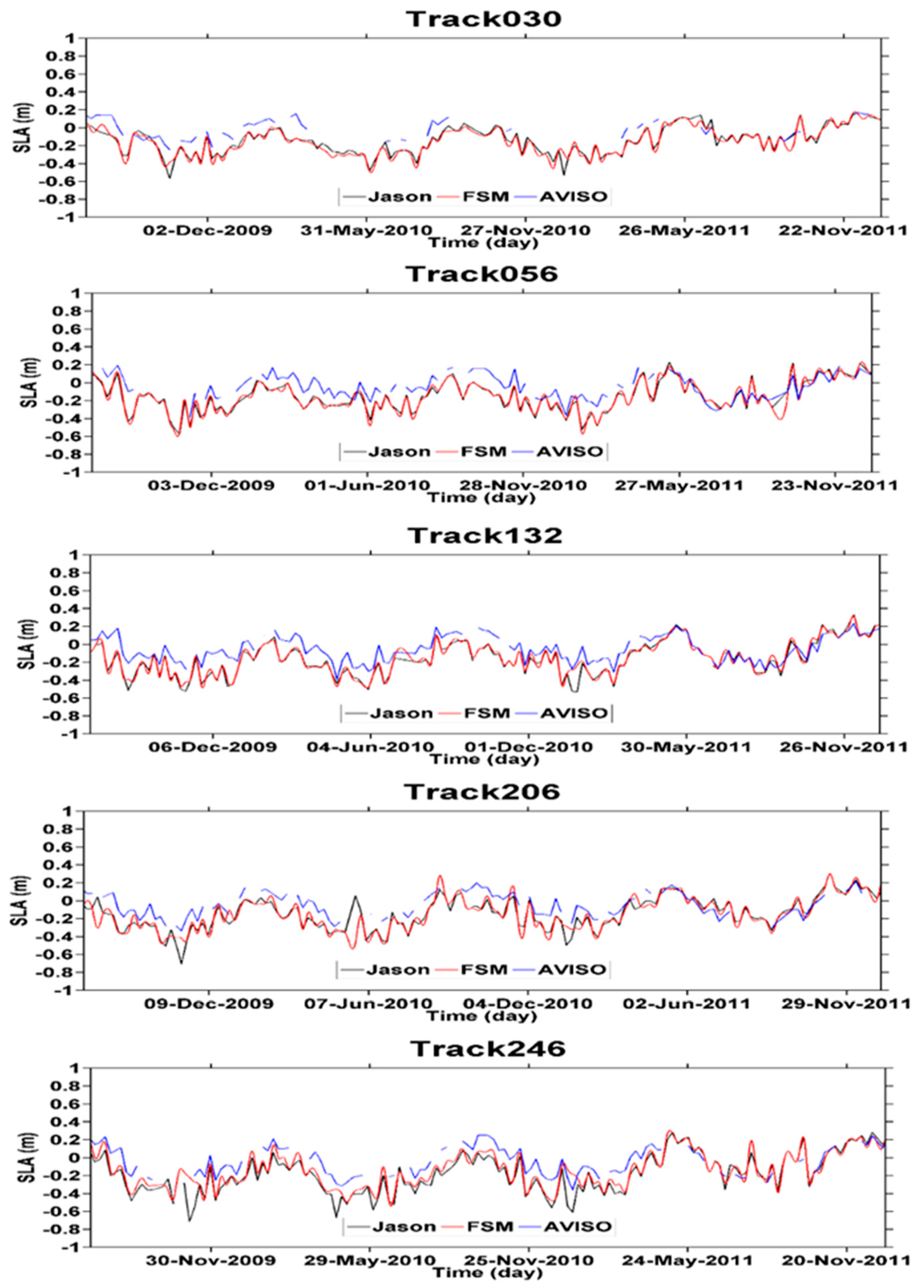
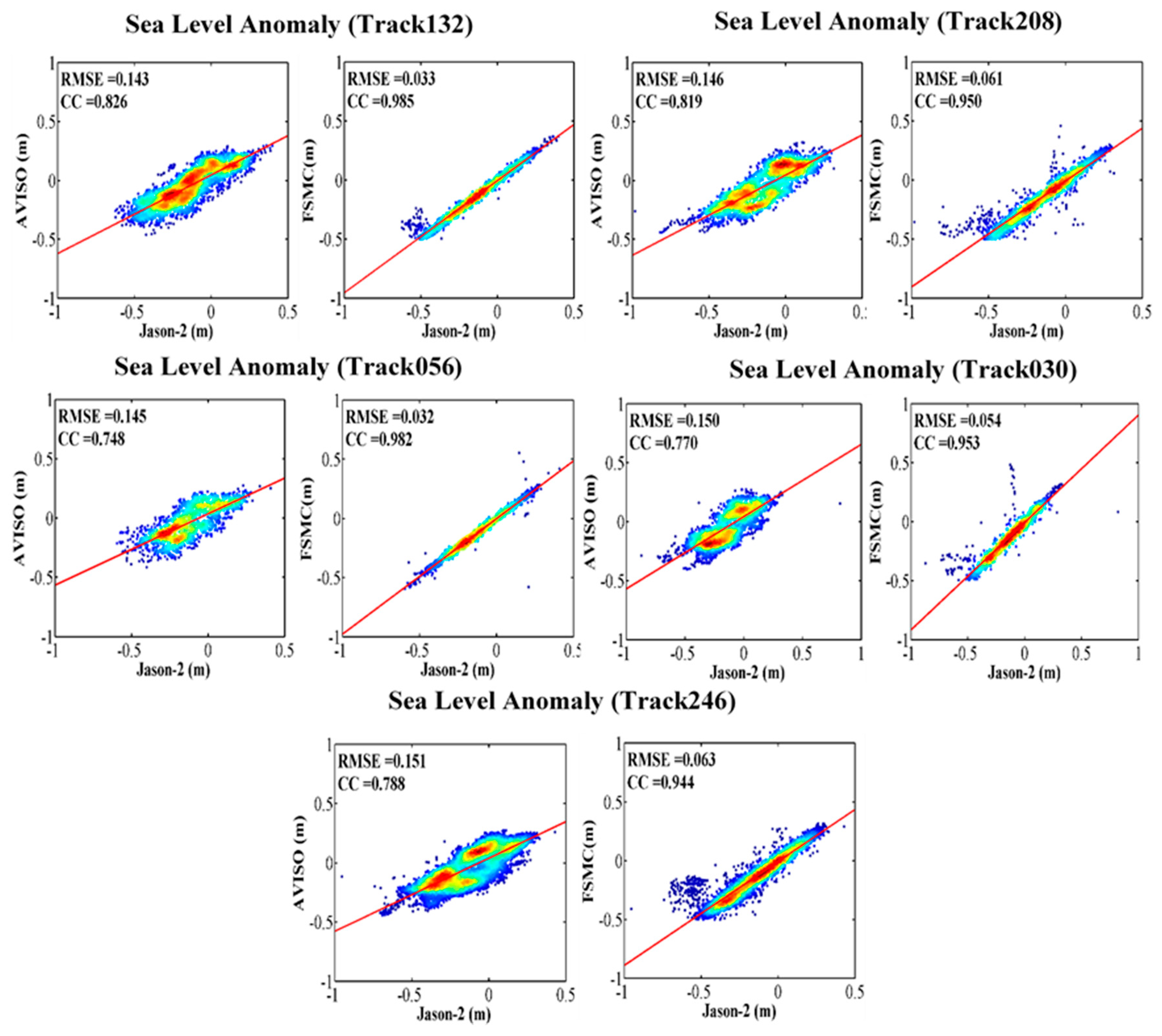
3.5. SLA Quality Inferred from FSM01
4. Conclusions
Author Contributions
Funding
Acknowledgments
Conflicts of Interest
References
- Chelton, D.B.; Schlax, M.G.; Samelson, R.M. Progress in Oceanography Global observations of nonlinear mesoscale eddies. Prog. Oceanogr. 2011, 91, 167–216. [Google Scholar] [CrossRef]
- Le Traon, P.Y. From satellite altimetry to Argo and operational oceanography: Three revolutions in oceanography. Ocean Sci. 2013, 9, 901–915. [Google Scholar] [CrossRef] [Green Version]
- Birol, F.; Delebecque, C. Using high sampling rate (10/20 Hz) altimeter data for the observation of coastal surface currents: A case study over the northwestern Mediterranean Sea. J. Mar. Syst. 2014, 129, 318–333. [Google Scholar] [CrossRef]
- Gommenginger, C.; Thibaut, P.; Fenoglio-Marc, L.; Quartly, G.; Deng, X.; Gómez-Enri, J.; Challenor, P.; Gao, Y. Retracking altimeter waveforms near the coasts. In Coastal Altimetry; Springer: Berlin/Heidelberg, Germany, 2011; pp. 61–101. [Google Scholar]
- Anzenhofer, M.; Shum, C.K.; Rentsh, M. Coastal altimetry and applications. Ohio State Univ. Geod. Sci. Surv. Tech. Rep. 1999, 464, 36. [Google Scholar]
- Deng, X.; Featherstone, W.E. A coastal retracking system for satellite radar altimeter waveforms: Application to ERS-2 around Australia. J. Geophys. Res. 2006, 111, 1–16. [Google Scholar] [CrossRef] [Green Version]
- Hwang, C.; Guo, J.; Deng, X.; Hsu, H.Y.; Liu, Y. Coastal gravity anomalies from retracked Geosat/GM altimetry: Improvement, limitation and the role of airborne gravity data. J. Geod. 2006, 80, 204–216. [Google Scholar] [CrossRef]
- Andersen, O.B.; Scharroo, R. Range and geophysical corrections in coastal regions: And implications for mean sea surface determination. In Coastal Altimetry; Vignudelli, S., Kostianoy, A.G., Cipollini, P., Benveniste, J., Eds.; Springer-Verlag: Berlin/Heidelberg, Germany, 2011; pp. 103–145. [Google Scholar]
- Birol, F.; Cancet, M.; Estournel, C. Aspects of the seasonal variability of the Northern Current (NW Mediterranean Sea) observed by altimetry. J. Mar. Syst. 2010, 81, 297–311. [Google Scholar] [CrossRef]
- Harley, C.D.G.; Randall Hughes, A.; Hultgren, K.M.; Miner, B.G.; Sorte, C.J.B.; Thornber, C.S.; Rodriguez, L.F.; Tomanek, L.; Williams, S.L. The impacts of climate change in coastal marine systems. Ecol. Lett. 2006, 9, 228–241. [Google Scholar] [CrossRef] [Green Version]
- Vignudelli, S.; Kostianoy, A.G.; Cipollini, P.; Benveniste, J. Coastal Altimetry; Springer cience & Business Media: Berlin/Heidelberg, Germany, 2011; ISBN 9783642127953. [Google Scholar]
- Passaro, M.; Cipollini, P.; Vignudelli, S.; Quartly, G.D.; Snaith, H.M. ALES: A multi-mission adaptive subwaveform retracker for coastal and open ocean altimetry. Remote Sens. Environ. 2014, 145, 173–189. [Google Scholar] [CrossRef] [Green Version]
- Vignudelli, S.; Snaith, H.M.; Lyard, F.; Cipollini, P.; Venuti, F.; Centre, N.O.; Way, E.; Southampton, S.O. Satellite radar altimetry from open ocean to coasts: Challenges and perspectives. Remote Sens. Mar. Environ. 2006, 6406, 1–12. [Google Scholar]
- Ghosh, S.; Kumar Thakur, P.; Garg, V.; Nandy, S.; Aggarwal, S.; Saha, S.K.; Sharma, R.; Bhattacharyya, S. SARAL/AltiKa Waveform Analysis to Monitor Inland Water Levels: A Case Study of Maithon Reservoir, Jharkhand, India. Mar. Geod. 2015, 38, 597–613. [Google Scholar] [CrossRef]
- Deng, X.; Featherstone, W.E.; Hwang, C.; Shum, C.K. Improved Coastal Marine Gravity Anomalies at the Taiwan Strait from Altimeter Waveform Retracking. In Proceedings of the International Workshop on Satellite Altimetry for Geodesy, Geophysics and Oceanography, Wuhan, China, 8–13 September 2001; pp. 1–9. [Google Scholar]
- Brooks, R.L.; Lockwood, D.W.; Lee, J.E.; Iii, D.W.H.; Hayne, G.S. Land Effects on TOPEX Radar Altimeter Measurements in Pacific Rim Coastal Zones. In Remote Sensing of the Pacific by Satellites; Brown, R.A., Ed.; Earth, Ocean, & Space Pty.: Glebe, Australia, 1998; pp. 175–198. [Google Scholar]
- Mercier, F.; Ablain, M.; Carrère, L.; Dibarboure, G.; Dufau, C.; Labroue, S.; Obligis, E.; Sicard, P.; Thibaut, P.; Commien, L.; et al. A CNES Initiative for Improved Altimeter Products in Coastal Zone; PISTACH, 2008; Available online: http://www.aviso.oceanobs.com/fieadmin/documents/OSTST/2008/Mercier_PISTACH.pdf (accessed on 26 February 2020).
- Drinkwater, M.; Bonekamp, H.; Bontempi, P.; Chapron, B.; Donlon, C.; Fellous, J.L.; DiGiacomo, P.; Harrison, E.; LeTraon, P.Y.; Wilson, S. Status and outlook for the space component of an integrated ocean observing system. In Proceedings of the OceanObs09: Sustained Ocean Observations and Information for Society, Venice, Italy, 21–25 September 2009. [Google Scholar] [CrossRef] [Green Version]
- Cipollini, P.; Vignudelli, S.; Lyard, F.; Roblou, L. 15 years of altimetry at various scales over the Mediterranean. In Remote Sensing of the European Seas; Springer: Berlin/Heidelberg, Germany, 2008; pp. 295–306. [Google Scholar]
- Guo, J.; Chang, X.; Gao, Y.; Sun, J.; Hwang, C. Lake level variations monitored with satellite altimetry waveform retracking. IEEE J. Sel. Top. Appl. Earth Obs. Remote Sens. 2009, 2, 80–86. [Google Scholar] [CrossRef]
- Guo, J.Y.; Gao, Y.G.; Hwang, C.W.; Sun, J.L. A multi-subwaveform parametric retracker of the radar satellite altimetric waveform and recovery of gravity anomalies over coastal oceans. Sci. China Earth Sci. 2010, 53, 610–616. [Google Scholar] [CrossRef]
- Khaki, M.; Forootan, E.; Sharifi, M.A. Satellite radar altimetry waveform retracking over the Caspian Sea. Int. J. Remote Sens. 2014, 35, 6329–6356. [Google Scholar] [CrossRef]
- Taqi, A.M.; Al-Subhi, A.M.; Alsaafani, M.A. Extension of Satellite Altimetry Jason-2 Sea Level Anomalies Towards the Red Sea Coast Using Polynomial Harmonic Techniques. Mar. Geod. 2017, 1–14. [Google Scholar] [CrossRef]
- Taqi, A.M.; Al-Subhi, A.M.; Alsaafani, M.A.; Abdulla, C.P. Estimation of geostrophic current in the Red Sea based on sea level anomalies derived from extended satellite altimetry data. Ocean Sci. 2019, 15, 477–488. [Google Scholar] [CrossRef] [Green Version]
- Dumont, J.P.; Rosmorduc, V.; Picot, N.; Bronner, E.; Desai, S.; Bonekamp, H.; Figa, J.; Lillibridge, J.; Scharroo, R. OSTM/Jason-2 Products Handbook; PL: STM-29-1237, NOAA/NESDIS: Polar Series/OSTM J; 2015; Volume 400. [Google Scholar]
- Obligis, E.; Desportes, C.; Eymard, L.; Fernandes, M.J.; Lázaro, C.; Nunes, A.L. Tropospheric Corrections for Coastal Altimetry. In Coastal Altimetry; Vignudelli, S., Kostianoy, A.G., Cipollini, P., Benveniste, J., Eds.; Springer-Verlag: Berlin/Heidelberg, Germany, 2011; pp. 147–176. ISBN 9783642127953. [Google Scholar]
- Imani, M.; You, R.; Kuo, C. Accurate Forecasting of the Satellite-Derived Seasonal Caspian Sea Level Anomaly Using Polynomial Interpolation and Holt-Winters Exponential Smoothing. Terr. Atmos. Ocean. Sci. 2013, 24, 521–530. [Google Scholar] [CrossRef] [Green Version]
- Fernandes, M.J.; Lázaro, C.; Ablain, M.; Pires, N. Remote Sensing of Environment Improved wet path delays for all ESA and reference altimetric missions. Remote Sens. Environ. 2015, 169, 50–74. [Google Scholar] [CrossRef] [Green Version]
- Bloomfield, P. Fourier analysis of time series: An introduction. J. R. Stat. Soc. Ser. A Gen. 2000, 140, 237. [Google Scholar]
- Thomson, R.E.; Emery, W.J. Data Analysis Methods in Physical Oceanography, 3rd ed.; Elsevier: Boston, MA, USA, 2014; ISBN 978-0-12-387782-6. [Google Scholar] [CrossRef]
- Daniell, P.J. Discussion on symposium on autocorrelation in time series. Suppl. J. R. Stat. Soc. 1946, 8, 88–90. [Google Scholar]
- Desportes, C.; Obligis, E.; Eymard, L. On Wet Tropospheric Correction for Altimetry in Coastal Regions. In Proceedings of the Envisat Symposium 2007, Montreux, Switzerland, 23–27 April 2007; pp. 23–27. [Google Scholar]
- Fernandes, M.J.; Lázaro, C.; Nunes, A.L.; Scharroo, R. Atmospheric Corrections for Altimetry Studies over Inland Water. Remote Sens. 2014, 6, 4952–4997. [Google Scholar] [CrossRef] [Green Version]




| Name of Station | Latitude | Longitude | Time |
|---|---|---|---|
| Jazan | 16°52′12″N | 42°33′00″E | 1 January 2012 to 31 December 2013 |
| Jeddah | 21°25′12″N | 39°9′00″E | 1 January 2012 to 31 December 2013 |
| Yanbu | 23°57′00″N | 38°15′00″E | 1 January 2012 to 31 December 2013 |
| Duba | 27°19′12″N | 35°43′12″E | 1 January 2012 to 31 December 2013 |
| Method | Bias | RMSE | Σ | Correlation | |
|---|---|---|---|---|---|
| Track030 | Aviso | 0.098 | 0.150 | 0.114 | 0.770 |
| FSM01 | 0.006 | 0.056 | 0.056 | 0.950 | |
| Track056 | Aviso | 0.087 | 0.146 | 0.117 | 0.748 |
| FSM01 | 0.001 | 0.033 | 0.033 | 0.982 | |
| Track132 | Aviso | 0.092 | 0.145 | 0.113 | 0.829 |
| FSM01 | 0.000 | 0.027 | 0.027 | 0.991 | |
| Track206 | Aviso | 0.092 | 0.146 | 0.113 | 0.820 |
| FSM01 | −0.001 | 0.039 | 0.039 | 0.981 | |
| Track246 | Aviso | 0.094 | 0.151 | 0.119 | 0.788 |
| FSM01 | −0.001 | 0.068 | 0.068 | 0.938 | |
| All Tracks | Aviso | 0.093 | 0.149 | 0.116 | 0.794 |
| FSM01 | 0.002 | 0.044 | 0.044 | 0.973 |
| Bias | RMSE | Std | Correlation | |
|---|---|---|---|---|
| Track030 | 0.07 | 0.10 | 0.07 | 0.92 |
| Track056 | 0.09 | 0.14 | 0.10 | 0.84 |
| Track132 | 0.02 | 0.08 | 0.08 | 0.92 |
| Track206 | 0.14 | 0.19 | 0.13 | 0.80 |
| Track246 | 0.08 | 0.12 | 0.08 | 0.91 |
© 2020 by the authors. Licensee MDPI, Basel, Switzerland. This article is an open access article distributed under the terms and conditions of the Creative Commons Attribution (CC BY) license (http://creativecommons.org/licenses/by/4.0/).
Share and Cite
Taqi, A.M.; Al-Subhi, A.M.; Alsaafani, M.A.; Abdulla, C.P. Improving Sea Level Anomaly Precision from Satellite Altimetry Using Parameter Correction in the Red Sea. Remote Sens. 2020, 12, 764. https://doi.org/10.3390/rs12050764
Taqi AM, Al-Subhi AM, Alsaafani MA, Abdulla CP. Improving Sea Level Anomaly Precision from Satellite Altimetry Using Parameter Correction in the Red Sea. Remote Sensing. 2020; 12(5):764. https://doi.org/10.3390/rs12050764
Chicago/Turabian StyleTaqi, Ahmed M., Abdullah M. Al-Subhi, Mohammed A. Alsaafani, and Cheriyeri P. Abdulla. 2020. "Improving Sea Level Anomaly Precision from Satellite Altimetry Using Parameter Correction in the Red Sea" Remote Sensing 12, no. 5: 764. https://doi.org/10.3390/rs12050764
APA StyleTaqi, A. M., Al-Subhi, A. M., Alsaafani, M. A., & Abdulla, C. P. (2020). Improving Sea Level Anomaly Precision from Satellite Altimetry Using Parameter Correction in the Red Sea. Remote Sensing, 12(5), 764. https://doi.org/10.3390/rs12050764


