Automated Mapping of Antarctic Supraglacial Lakes Using a Machine Learning Approach


Abstract

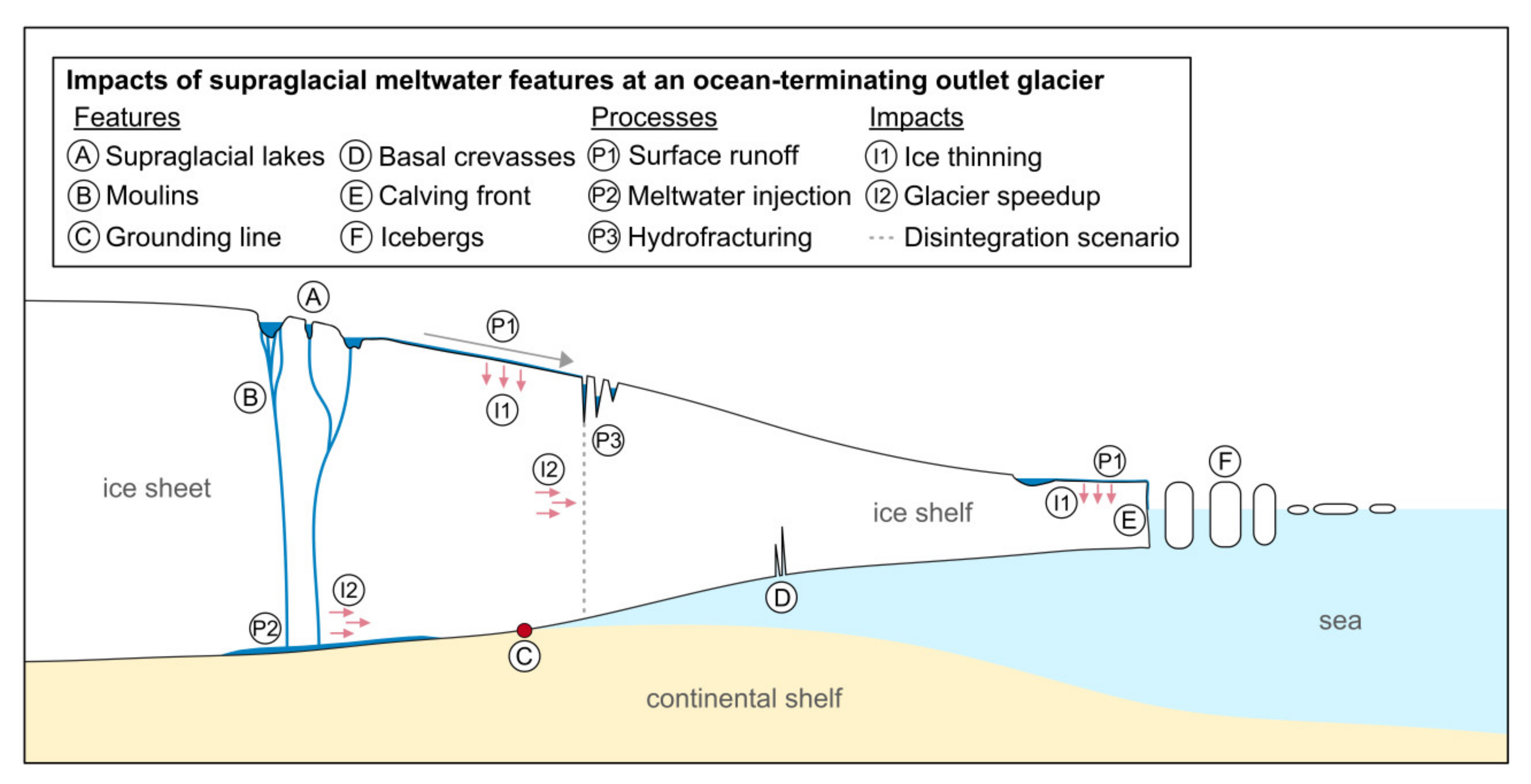
1. Introduction
2. Data and Methods
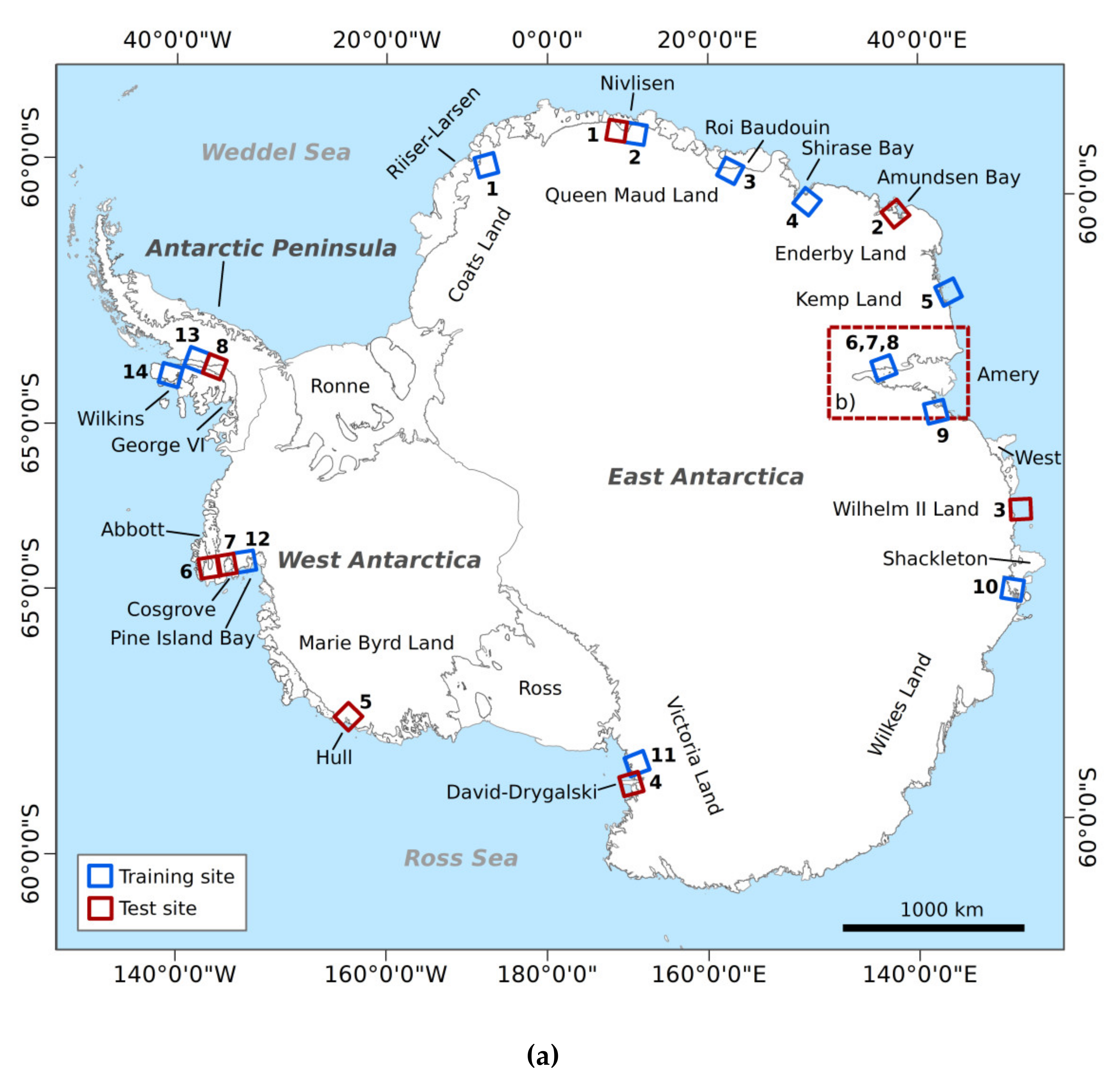
2.1. Selection of Study Sites
2.2. Input Data
2.2.1. Sentinel-2
2.2.2. TanDEM-X DEM
2.2.3. Training Labels
2.2.4. Data Harmonization
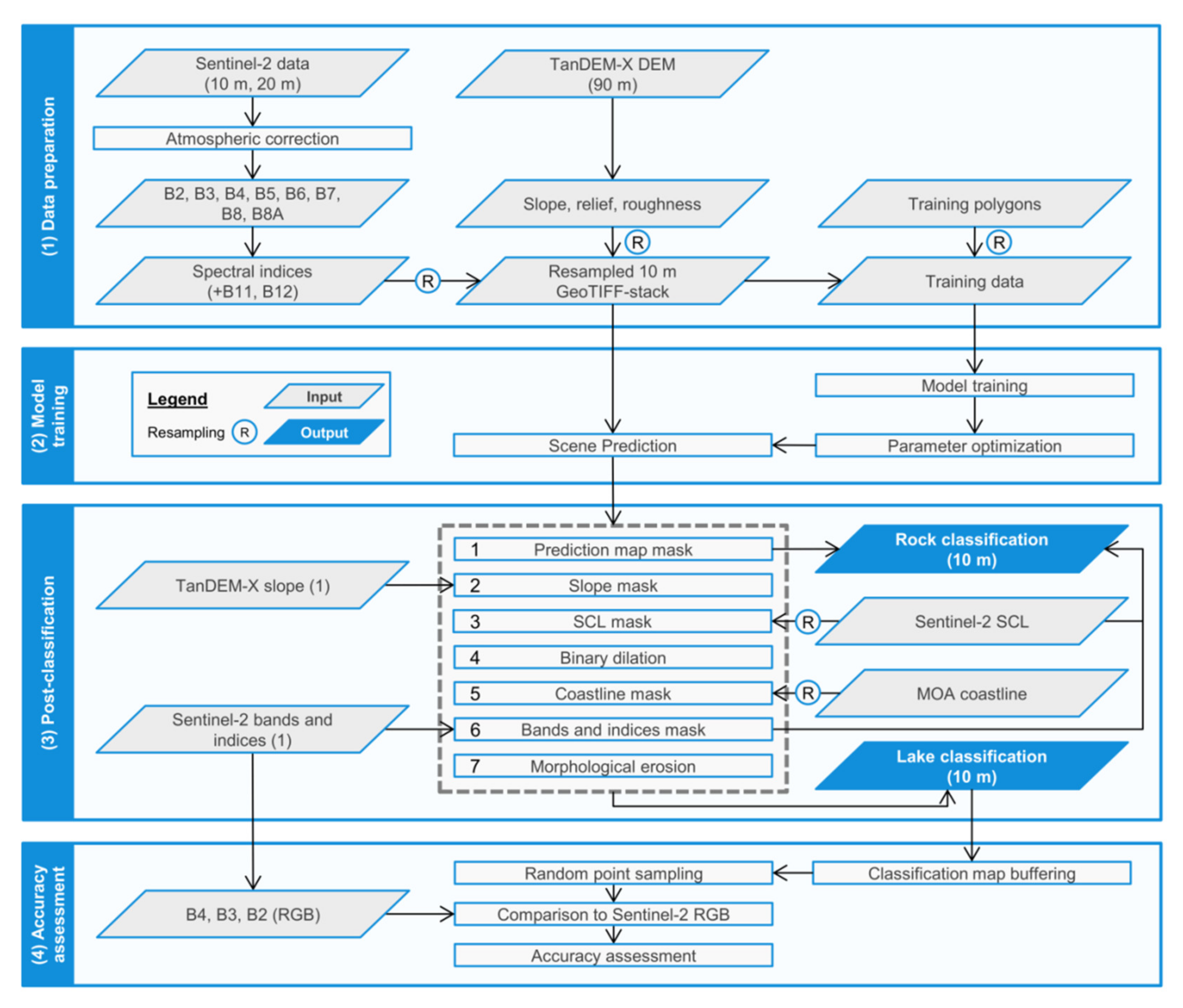
2.3. Image Classification
2.3.1. Random Forest Classifier
2.3.2. Postclassification
2.4. Accuracy Assessment
3. Results
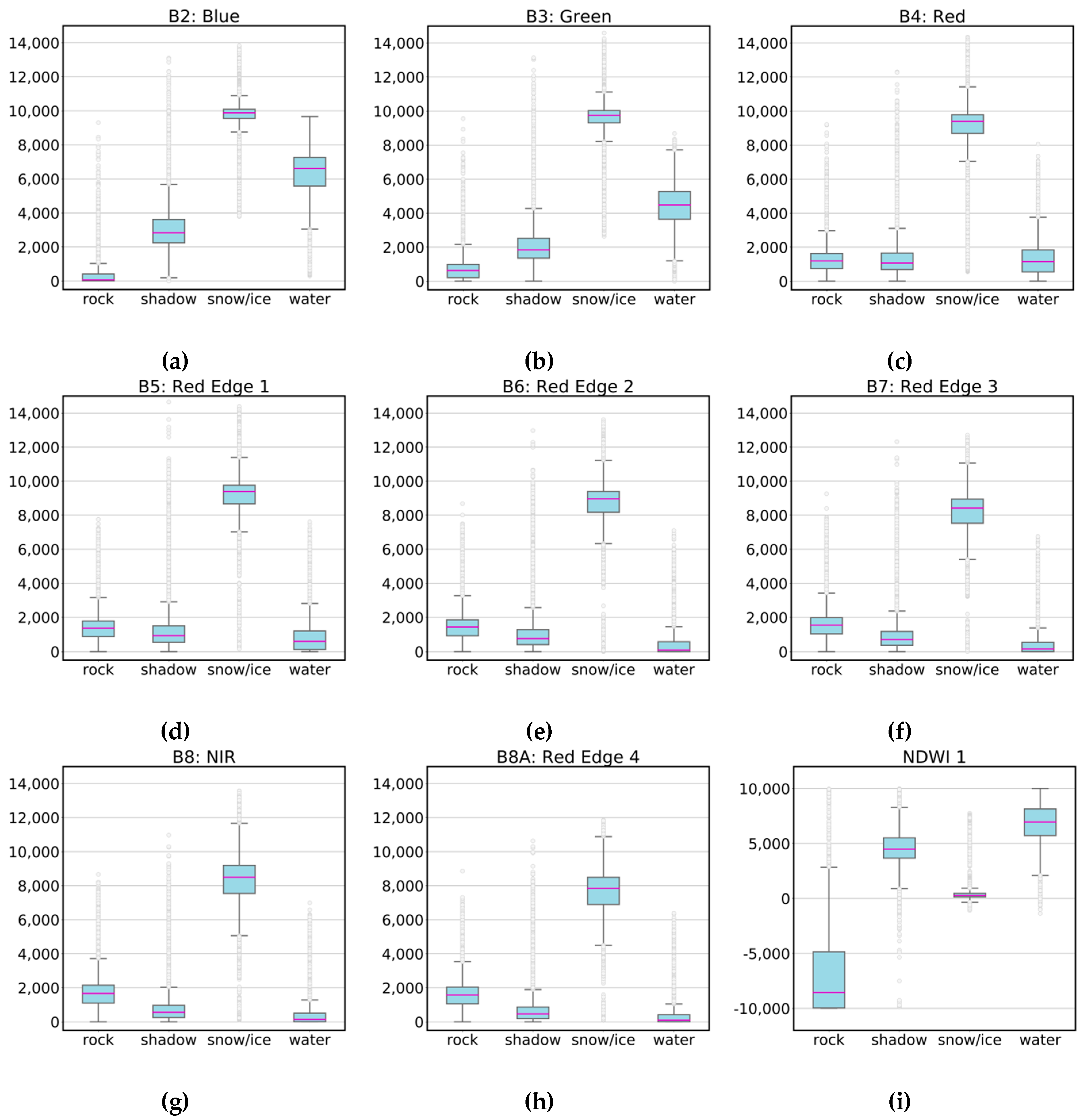
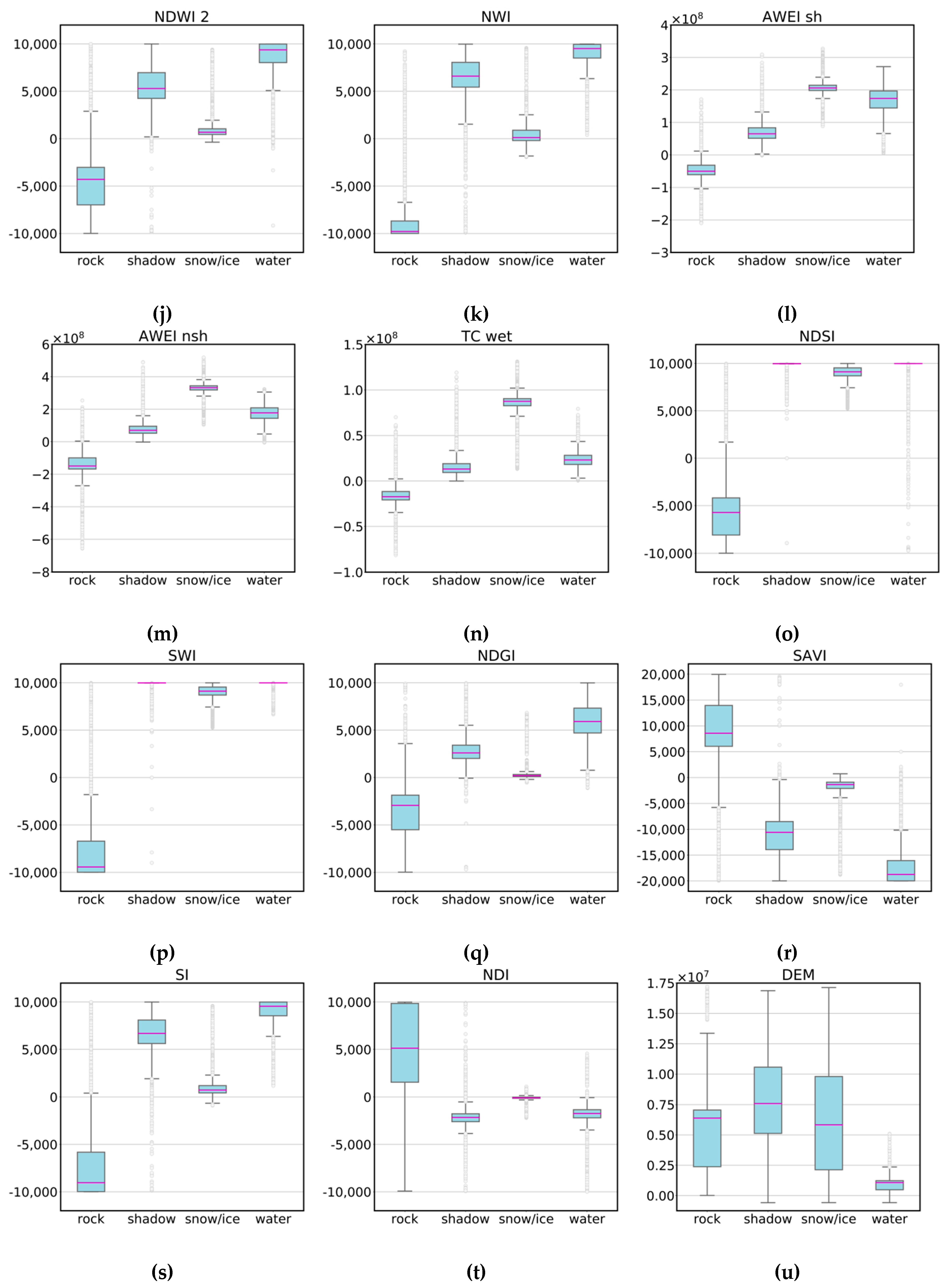
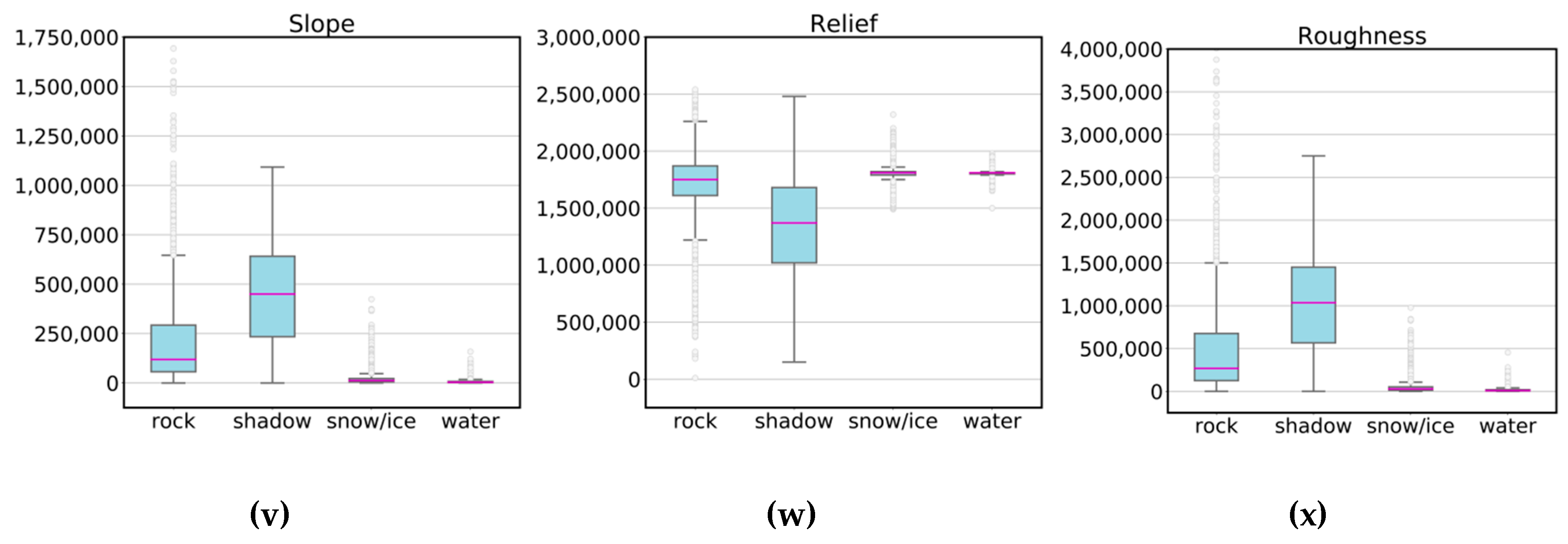
3.1. Importance of Variables
3.2. Lake Extent Mapping
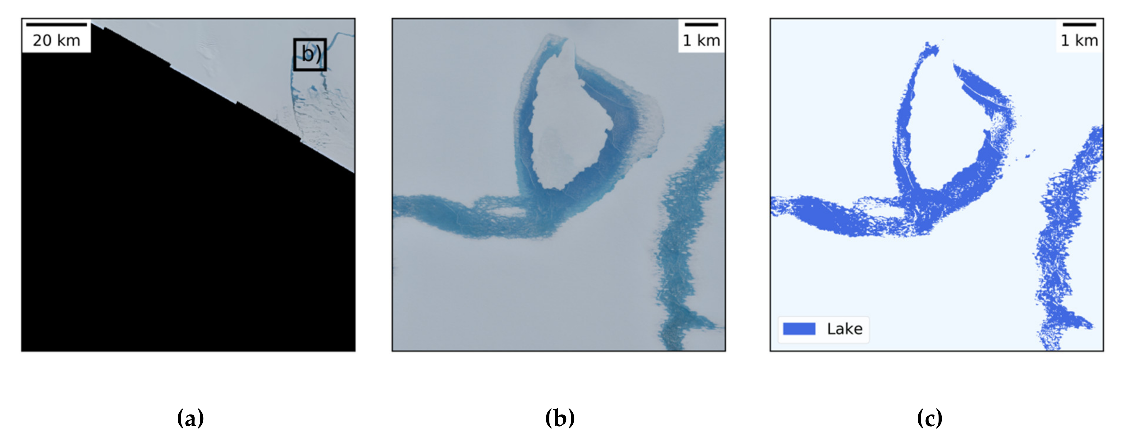
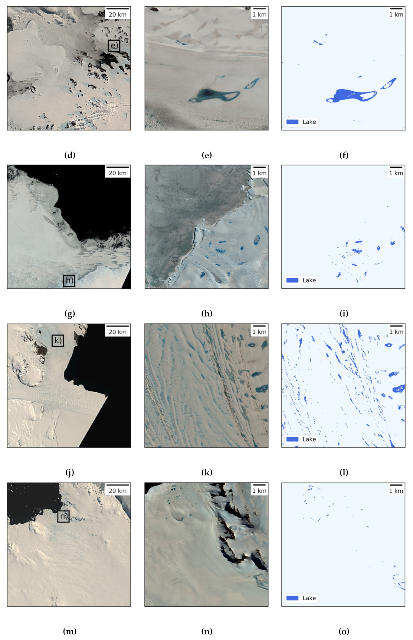
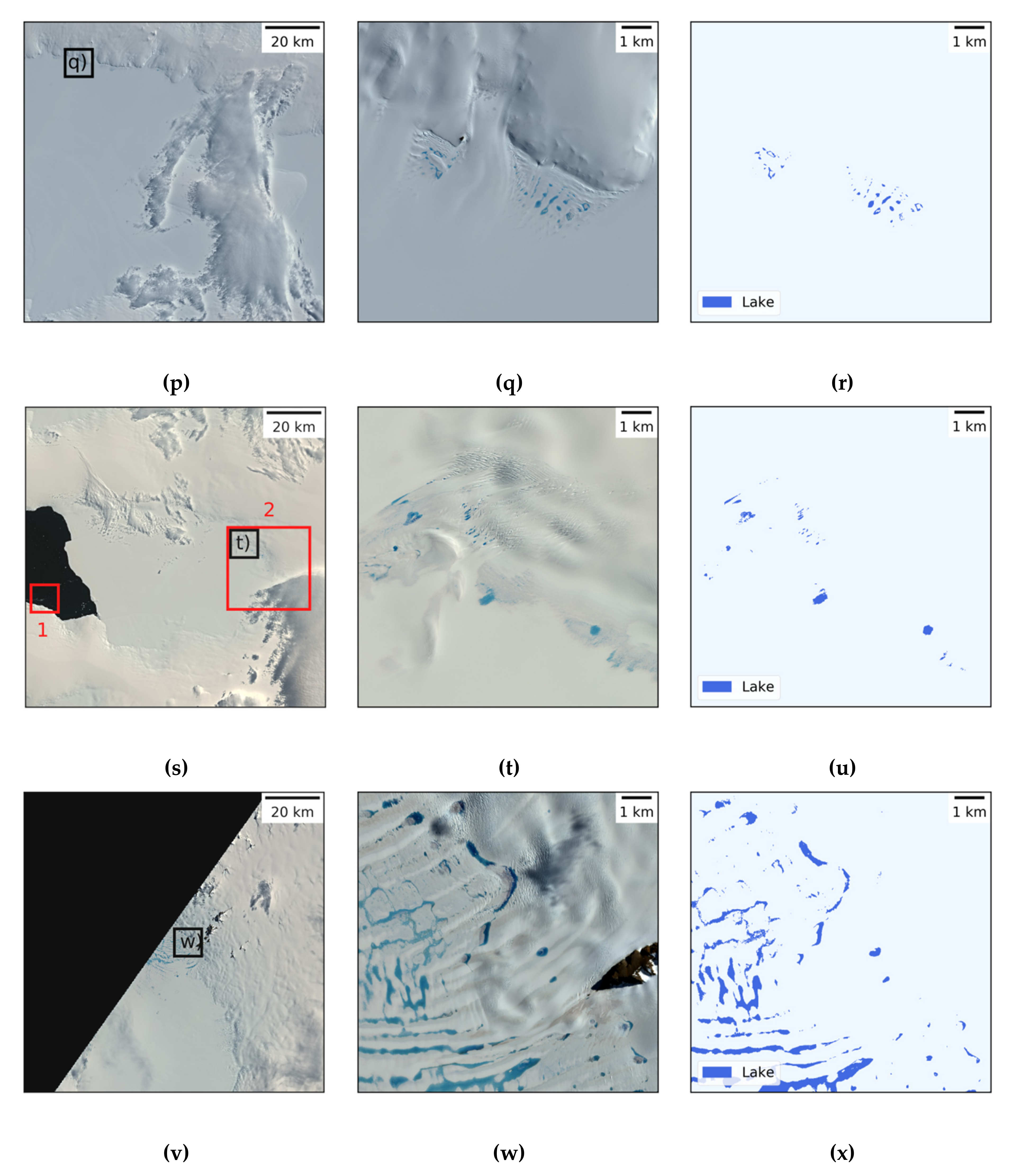
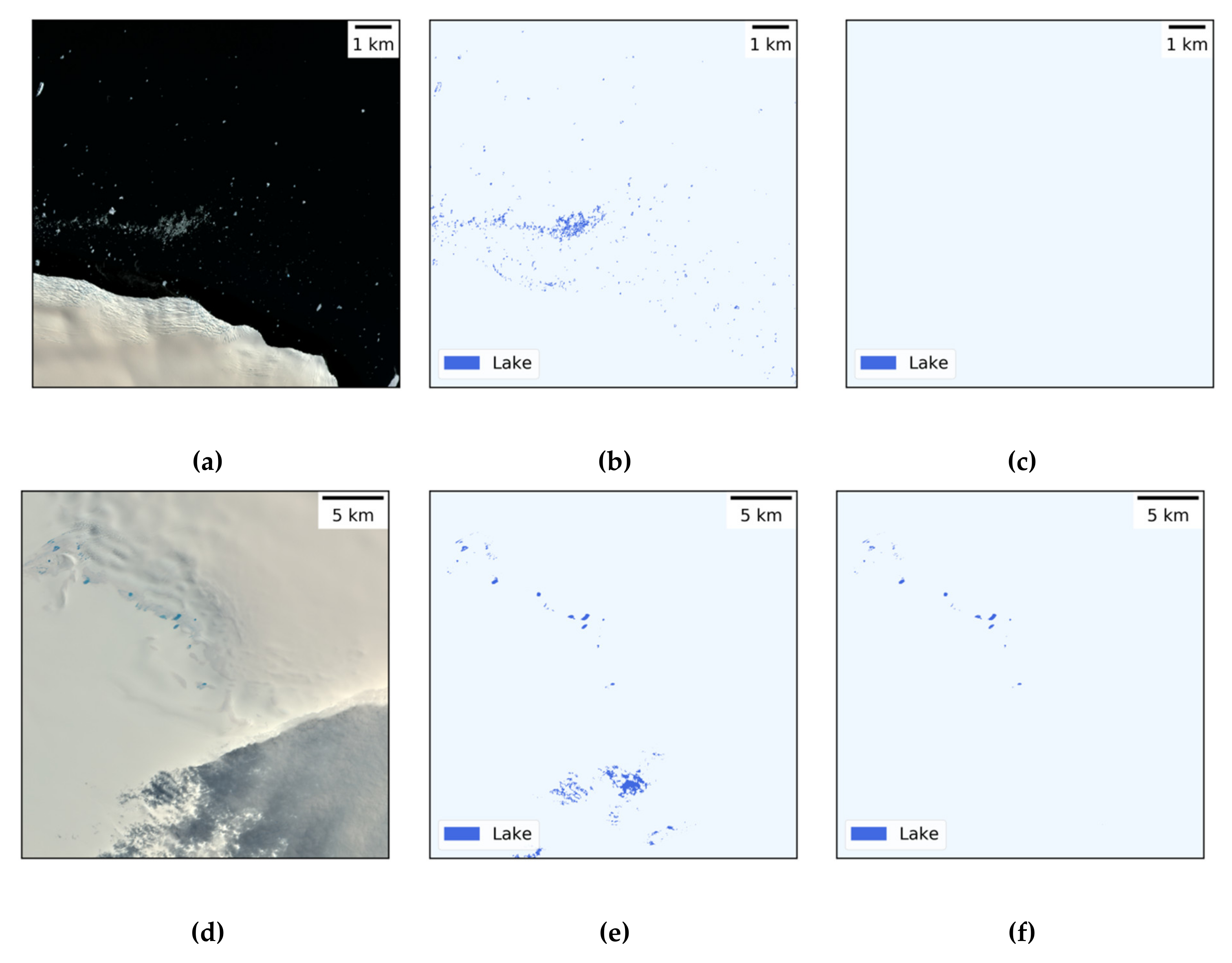
3.2.1. Test Regions
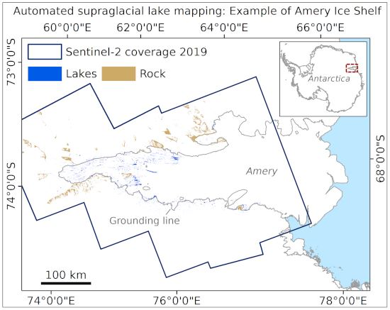
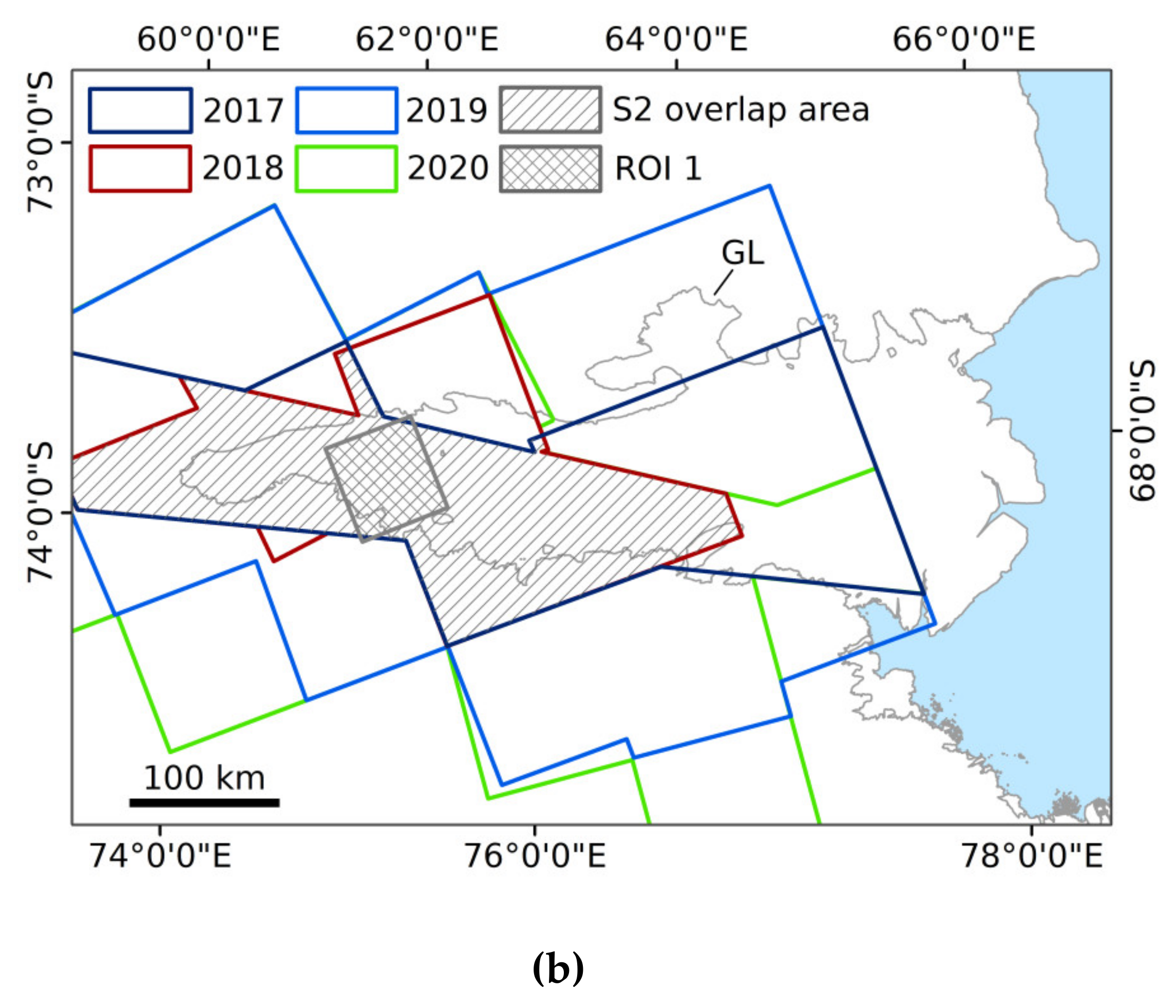
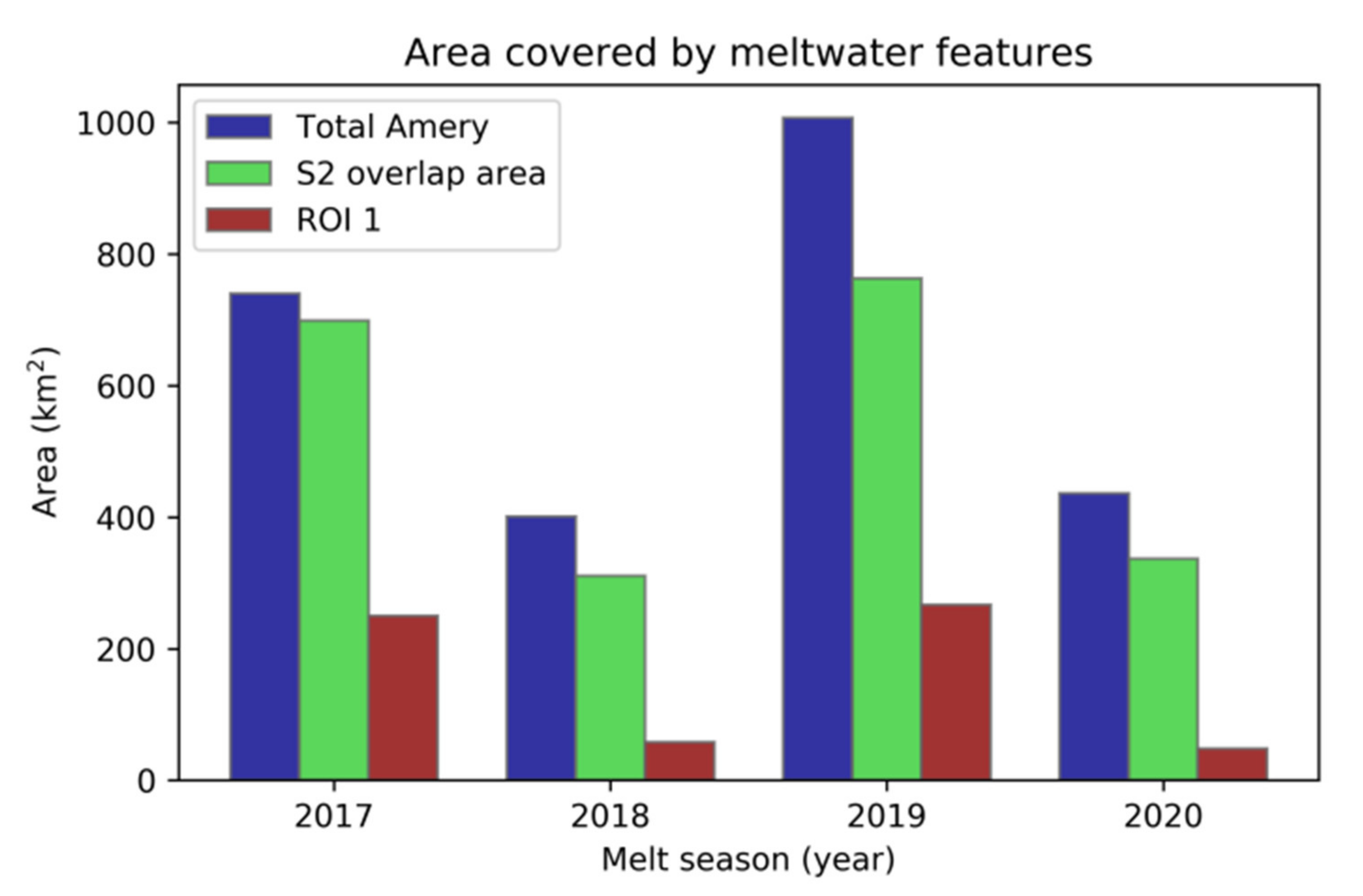
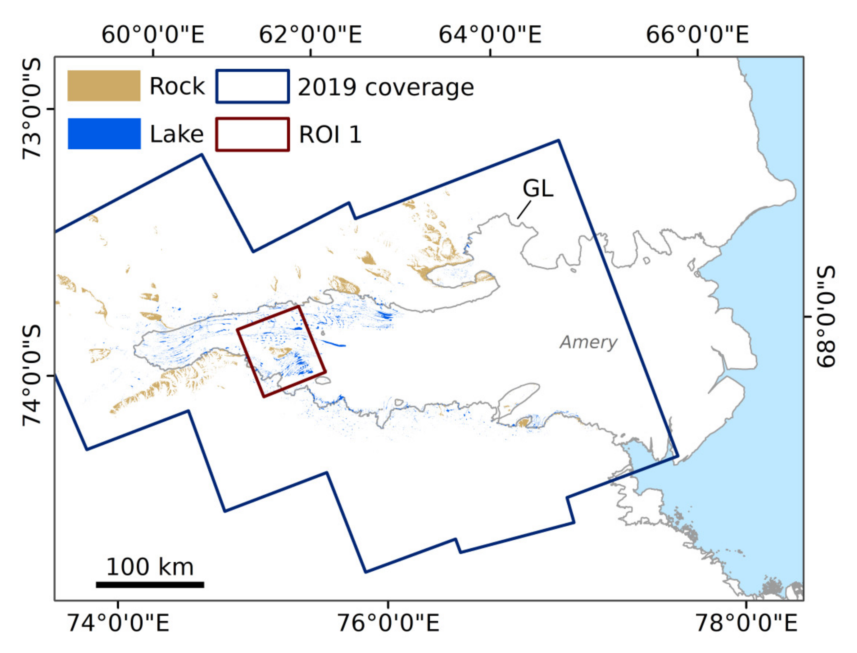
3.2.2. Spatio-Temporal Lake Dynamics on Amery Ice Shelf
3.3. Accuracy Assessment
4. Discussion
4.1. Importance of Variables
4.2. Mapping Results
4.3. Accuracy Assessment
4.4. Future Requirements
5. Conclusions
Supplementary Materials
Author Contributions
Funding
Acknowledgments
Conflicts of Interest
References
- Swithinbank, C. Satellite Image Atlas of Glaciers of the World: Antarctica; U.S. Geological Survey Professional Paper 1386B; United States Government Printing Office: Washington, DC, USA, 1988. [Google Scholar]
- IPCC Climate Change 2013. The Physical Science Basis. Contribution of Working Group I to the Fifth Assessment Report of the Intergovernmental Panel on Climate Change; Stocker, T.F., Qin, D., Plattner, G.K., Tignor, M., Allen, S.K., Boschung, J., Nauels, A., Xia, Y., Bex, V., Midgley, P.M., Eds.; Cambridge University Press: Cambridge, UK; New York, NY, USA, 2013. [Google Scholar]
- Echelmeyer, K.; Clarke, T.S.; Harrison, W.D. Surficial glaciology of Jakobshavns Isbræ, West Greenland: Part I. Surface morphology. J. Glaciol. 1991, 37, 368–382. [Google Scholar] [CrossRef][Green Version]
- Bell, R.E.; Banwell, A.F.; Trusel, L.D.; Kingslake, J. Antarctic surface hydrology and impacts on ice-sheet mass balance. Nat. Clim. Chang. 2018, 8, 1044–1052. [Google Scholar] [CrossRef]
- Das, S.B.; Joughin, I.; Behn, M.D.; Howat, I.M.; King, M.A.; Lizarralde, D.; Bhatia, M.P. Fracture Propagation to the Base of the Greenland Ice Sheet During Supraglacial Lake Drainage. Science 2008, 320, 778–781. [Google Scholar] [CrossRef]
- Shepherd, A.; Hubbard, A.; Nienow, P.; King, M.; McMillan, M.; Joughin, I. Greenland ice sheet motion coupled with daily melting in late summer. Geophys. Res. Lett. 2009, 36, L01501. [Google Scholar] [CrossRef]
- Tedesco, M.; Willis, I.C.; Hoffman, M.J.; Banwell, A.F.; Alexander, P.; Arnold, N.S. Ice dynamic response to two modes of surface lake drainage on the Greenland ice sheet. Environ. Res. Lett. 2013, 8, 034007. [Google Scholar] [CrossRef]
- Zwally, H.J.; Abdalati, W.; Herring, T.; Larson, K.; Saba, J.; Steffen, K. Surface Melt-Induced Acceleration of Greenland Ice-Sheet Flow. Science 2002, 297, 218–222. [Google Scholar] [CrossRef] [PubMed]
- Bartholomew, I.; Nienow, P.; Mair, D.; Hubbard, A.; King, M.A.; Sole, A. Seasonal evolution of subglacial drainage and acceleration in a Greenland outlet glacier. Nat. Geosci 2010, 3, 408–411. [Google Scholar] [CrossRef]
- Tuckett, P.A.; Ely, J.C.; Sole, A.J.; Livingstone, S.J.; Davison, B.J.; van Wessem, J.M.; Howard, J. Rapid accelerations of Antarctic Peninsula outlet glaciers driven by surface melt. Nat. Commun. 2019, 10, 1–8. [Google Scholar] [CrossRef]
- Banwell, A.F.; Macayeal, D.R. Ice-shelf fracture due to viscoelastic flexure stress induced by fill/drain cycles of supraglacial lakes. Antarct. Sci. 2015, 27, 587–597. [Google Scholar] [CrossRef]
- Banwell, A.F.; MacAyeal, D.R.; Sergienko, O.V. Breakup of the Larsen B Ice Shelf triggered by chain reaction drainage of supraglacial lakes. Geophys. Res. Lett. 2013, 40, 5872–5876. [Google Scholar] [CrossRef]
- De Angelis, H.; Skvarca, P. Glacier Surge After Ice Shelf Collapse. Science 2003, 299, 1560–1562. [Google Scholar] [CrossRef]
- Rignot, E.; Casassa, G.; Gogineni, P.; Krabill, W.; Rivera, A.; Thomas, R. Accelerated ice discharge from the Antarctic Peninsula following the collapse of Larsen B ice shelf. Geophys. Res. Lett. 2004, 31. [Google Scholar] [CrossRef]
- Glasser, N.F.; Scambos, T.A. A structural glaciological analysis of the 2002 Larsen B ice-shelf collapse. J. Glaciol. 2008, 54, 3–16. [Google Scholar] [CrossRef]
- Rott, H.; Abdel Jaber, W.; Wuite, J.; Scheiblauer, S.; Floricioiu, D.; Van Wessem, J.M.; Nagler, T.; Miranda, N.; Van den Broeke, M.R. Changing pattern of ice flow and mass balance for glaciers discharging into the Larsen A and B embayments, Antarctic Peninsula, 2011 to 2016. Cryosphere 2018, 12, 1273–1291. [Google Scholar] [CrossRef]
- Scambos, T.A.; Bohlander, J.A.; Shuman, C.A.; Skvarca, P. Glacier acceleration and thinning after ice shelf collapse in the Larsen B embayment, Antarctica. Geophys. Res. Lett. 2004, 31. [Google Scholar] [CrossRef]
- Tedesco, M.; Lüthje, M.; Steffen, K.; Steiner, N.; Fettweis, X.; Willis, I.; Bayou, N.; Banwell, A. Measurement and modeling of ablation of the bottom of supraglacial lakes in western Greenland. Geophys. Res. Lett. 2012, 39. [Google Scholar] [CrossRef]
- Lüthje, M.; Pedersen, L.T.; Reeh, N.; Greuell, W. Modelling the evolution of supraglacial lakes on the West Greenland ice-sheet margin. J. Glaciol. 2006, 52, 608–618. [Google Scholar] [CrossRef]
- Stokes, C.R.; Sanderson, J.E.; Miles, B.W.J.; Jamieson, S.S.R.; Leeson, A.A. Widespread distribution of supraglacial lakes around the margin of the East Antarctic Ice Sheet. Sci. Rep. 2019, 9, 13823. [Google Scholar] [CrossRef]
- Kingslake, J.; Ely, J.C.; Das, I.; Bell, R. Widespread movement of meltwater onto and across Antarctic ice shelves. Nature 2017, 544, 349–352. [Google Scholar] [CrossRef]
- Enderlin, E.M.; Howat, I.M.; Jeong, S.; Noh, M.J.; van Angelen, J.H.; van den Broeke, M.R. An improved mass budget for the Greenland ice sheet. Geophys. Res. Lett. 2014, 41, 866–872. [Google Scholar] [CrossRef]
- Box, J.E.; Ski, K. Remote sounding of Greenland supraglacial melt lakes: Implications for subglacial hydraulics. J. Glaciol. 2007, 53, 257–265. [Google Scholar] [CrossRef]
- Howat, I.M.; de la Peña, S.; van Angelen, J.H.; Lenaerts, J.T.M.; van den Broeke, M.R. Brief Communication: “Expansion of meltwater lakes on the Greenland Ice Sheet”. Cryosphere 2013, 7, 201–204. [Google Scholar] [CrossRef]
- Moussavi, M.S.; Abdalati, W.; Pope, A.; Scambos, T.; Tedesco, M.; MacFerrin, M.; Grigsby, S. Derivation and validation of supraglacial lake volumes on the Greenland Ice Sheet from high-resolution satellite imagery. Remote Sens. Environ. 2016, 183, 294–303. [Google Scholar] [CrossRef]
- Miles, K.E.; Willis, I.C.; Benedek, C.L.; Williamson, A.G.; Tedesco, M. Toward Monitoring Surface and Subsurface Lakes on the Greenland Ice Sheet Using Sentinel-1 SAR and Landsat-8 OLI Imagery. Front. Earth Sci. 2017, 5. [Google Scholar] [CrossRef]
- Sundal, A.V.; Shepherd, A.; Nienow, P.; Hanna, E.; Palmer, S.; Huybrechts, P. Evolution of supra-glacial lakes across the Greenland Ice Sheet. Remote Sens. Environ. 2009, 113, 2164–2171. [Google Scholar] [CrossRef]
- Selmes, N.; Murray, T.; James, T.D. Fast draining lakes on the Greenland Ice Sheet. Geophys. Res. Lett. 2011, 38. [Google Scholar] [CrossRef]
- Johansson, A.M.; Brown, I.A. Adaptive Classification of Supra-Glacial Lakes on the West Greenland Ice Sheet. IEEE J. Sel. Top. Appl. Earth Obs. Remote Sens. 2013, 6, 1998–2007. [Google Scholar] [CrossRef]
- Williamson, A.G.; Arnold, N.S.; Banwell, A.F.; Willis, I.C. A Fully Automated Supraglacial lake area and volume Tracking (“FAST”) algorithm: Development and application using MODIS imagery of West Greenland. Remote Sens. Environ. 2017, 196, 113–133. [Google Scholar] [CrossRef]
- Liang, Y.-L.; Colgan, W.; Lv, Q.; Steffen, K.; Abdalati, W.; Stroeve, J.; Gallaher, D.; Bayou, N. A decadal investigation of supraglacial lakes in West Greenland using a fully automatic detection and tracking algorithm. Remote Sens. Environ. 2012, 123, 127–138. [Google Scholar] [CrossRef]
- Leeson, A.A.; Shepherd, A.; Sundal, A.V.; Johansson, A.M.; Selmes, N.; Briggs, K.; Hogg, A.E.; Fettweis, X. A comparison of supraglacial lake observations derived from MODIS imagery at the western margin of the Greenland ice sheet. J. Glaciol. 2013, 59, 1179–1188. [Google Scholar] [CrossRef]
- Langley, E.S.; Leeson, A.A.; Stokes, C.R.; Jamieson, S.S.R. Seasonal evolution of supraglacial lakes on an East Antarctic outlet glacier. Geophys. Res. Lett. 2016, 43, 8563–8571. [Google Scholar] [CrossRef]
- Kingslake, J.; Ng, F.; Sole, A. Modelling channelized surface drainage of supraglacial lakes. J. Glaciol. 2015, 61, 185–199. [Google Scholar] [CrossRef]
- Bell, R.E.; Chu, W.; Kingslake, J.; Das, I.; Tedesco, M.; Tinto, K.J.; Zappa, C.J.; Frezzotti, M.; Boghosian, A.; Lee, W.S. Antarctic ice shelf potentially stabilized by export of meltwater in surface river. Nature 2017, 544, 344–348. [Google Scholar] [CrossRef] [PubMed]
- Munneke, P.K.; Luckman, A.J.; Bevan, S.L.; Smeets, C.J.P.P.; Gilbert, E.; van den Broeke, M.R.; Wang, W.; Zender, C.; Hubbard, B.; Ashmore, D.; et al. Intense Winter Surface Melt on an Antarctic Ice Shelf. Available online: https://agupubs.onlinelibrary.wiley.com/doi/abs/10.1029/2018GL077899 (accessed on 12 July 2019).
- Leeson, A.A.; Forster, E.; Rice, A.; Gourmelen, N.; Van Wessem, J.M. Evolution of supraglacial lakes on the Larsen B ice shelf in the decades before it collapsed. Geophys. Res. Lett. 2020, 47, e2019GL085591. [Google Scholar] [CrossRef]
- Fricker, H.A.; Coleman, R.; Padman, L.; Scambos, T.A.; Bohlander, J.; Brunt, K.M. Mapping the grounding zone of the Amery Ice Shelf, East Antarctica using InSAR, MODIS and ICESat. Antarct. Sci. 2009, 21, 515–532. [Google Scholar] [CrossRef]
- Miles, B.W.J.; Stokes, C.R.; Vieli, A.; Cox, N.J. Rapid, climate-driven changes in outlet glaciers on the Pacific coast of East Antarctica. Nature 2013, 500, 563–566. [Google Scholar] [CrossRef]
- Moussavi, M.; Pope, A.; Halberstadt, A.R.W.; Trusel, L.D.; Cioffi, L.; Abdalati, W. Antarctic Supraglacial Lake Detection Using Landsat 8 and Sentinel-2 Imagery: Towards Continental Generation of Lake Volumes. Remote Sens. 2020, 12, 134. [Google Scholar] [CrossRef]
- Hanna, E.; Navarro, F.J.; Pattyn, F.; Domingues, C.M.; Fettweis, X.; Ivins, E.R.; Nicholls, R.J.; Ritz, C.; Smith, B.; Tulaczyk, S.; et al. Ice-sheet mass balance and climate change. Nature 2013, 498, 51–59. [Google Scholar] [CrossRef] [PubMed]
- Shepherd, A.; Ivins, E.R.; Geruo, A.; Barletta, V.R.; Bentley, M.J.; Bettadpur, S.; Horwath, M. A Reconciled Estimate of Ice-Sheet Mass Balance. Science 2012, 338, 1183–1189. [Google Scholar] [CrossRef]
- Rignot, E.; Jacobs, S.; Mouginot, J.; Scheuchl, B. Ice-Shelf Melting Around Antarctica. Science 2013, 341, 266–270. [Google Scholar] [CrossRef] [PubMed]
- Fürst, J.J.; Durand, G.; Gillet-Chaulet, F.; Tavard, L.; Rankl, M.; Braun, M.; Gagliardini, O. The safety band of Antarctic ice shelves. Nat. Clim. Chang. 2016, 6, 479–482. [Google Scholar] [CrossRef]
- Dupont, T.K.; Alley, R.B. Assessment of the importance of ice-shelf buttressing to ice-sheet flow. Geophys. Res. Lett. 2005, 32. [Google Scholar] [CrossRef]
- Trusel, L.D.; Frey, K.E.; Das, S.B.; Karnauskas, K.B.; Kuipers Munneke, P.; van Meijgaard, E.; van den Broeke, M.R. Divergent trajectories of Antarctic surface melt under two twenty-first-century climate scenarios. Nat. Geosci. 2015, 8, 927–932. [Google Scholar] [CrossRef]
- Zheng, L.; Zhou, C. Comparisons of snowmelt detected by microwave sensors on the Shackleton Ice Shelf, East Antarctica. Int. J. Remote Sens. 2019, 41, 1338–1348. [Google Scholar] [CrossRef]
- Lenaerts, J.T.M.; Lhermitte, S.; Drews, R.; Ligtenberg, S.R.M.; Berger, S.; Helm, V.; Smeets, C.J.P.P.; van den Broeke, M.R.; van de Berg, W.J.; van Meijgaard, E.; et al. Meltwater produced by wind–albedo interaction stored in an East Antarctic ice shelf. Nat. Clim. Chang. 2017, 7, 58–62. [Google Scholar] [CrossRef]
- Hambrey, M.J.; Davies, B.J.; Glasser, N.F.; Holt, T.O.; Smellie, J.L.; Carrivick, J.L. Structure and sedimentology of George VI Ice Shelf, Antarctic Peninsula: Implications for ice-sheet dynamics and landform development. J. Geol. Soc. 2015, 172, 599–613. [Google Scholar] [CrossRef]
- SCAR Antarctic Digital Database (ADD). Available online: https://www.add.scar.org/ (accessed on 3 December 2019).
- ESA Copernicus Open Access Hub. Available online: https://scihub.copernicus.eu/ (accessed on 4 April 2020).
- ESA Sentinel-2 User Handbook. 2015. Available online: https://sentinel.esa.int/documents/247904/685211/Sentinel-2_User_Handbook (accessed on 7 April 2020).
- Louis, J.; Debaecker, V.; Pflug, B.; Main-Knorn, M.; Bieniarz, J.; Mueller-Wilm, U.; Cadau, E.; Gascon, F. Sentinel-2 Sen2Cor: L2A Processor For Users. In Proceedings of the Living Planet Symposium 2016, Prague, Czech Republic, 9–13 May 2016; Volume ESA SP-7 4. [Google Scholar]
- Yang, K.; Smith, L.C. Supraglacial Streams on the Greenland Ice Sheet Delineated from Combined Spectral–Shape Information in High-Resolution Satellite Imagery. IEEE Geosci. Remote Sens. Lett. 2013, 10, 801–805. [Google Scholar] [CrossRef]
- McFeeters, S.K. The use of the Normalized Difference Water Index (NDWI) in the delineation of open water features. Int. J. Remote Sens. 1996, 17, 1425–1432. [Google Scholar] [CrossRef]
- Ding, F. Study on information extraction of water body with a new water index (NWI). Sci. Surv. Mapp. 2009, 34, 155–158. [Google Scholar]
- Kauth, R.J.; Thomas, G.S. The tasselled cap—A graphic description of the spectral-temporal development of agricultural crops as seen by Landsat. In Proceedings of the Symposium on Machine Processing of Remotely Sensed Data, West Lafayette, IN, USA, 29 June–1 July 1976; Volume 4B, pp. 41–51. [Google Scholar]
- Schwatke, C.; Scherer, D.; Dettmering, D. Automated Extraction of Consistent Time-Variable Water Surfaces of Lakes and Reservoirs Based on Landsat and Sentinel-2. Remote Sens. 2019, 11, 1010. [Google Scholar] [CrossRef]
- Feyisa, G.L.; Meilby, H.; Fensholt, R.; Proud, S.R. Automated Water Extraction Index: A new technique for surface water mapping using Landsat imagery. Remote Sens. Environ. 2014, 140, 23–35. [Google Scholar] [CrossRef]
- Huete, A.R. A soil-adjusted vegetation index (SAVI). Remote Sens. Environ. 1988, 25, 295–309. [Google Scholar] [CrossRef]
- Xu, H. Modification of normalised difference water index (NDWI) to enhance open water features in remotely sensed imagery. Int. J. Remote Sens. 2006, 27, 3025–3033. [Google Scholar] [CrossRef]
- Hall, D.K.; Riggs, G.A.; Salomonson, V.V. Development of methods for mapping global snow cover using moderate resolution imaging spectroradiometer data. Remote Sens. Environ. 1995, 54, 127–140. [Google Scholar] [CrossRef]
- ESA Sentinel-2 MSI Level-2A Algorithm Overview. Available online: https://earth.esa.int/web/sentinel/technical-guides/sentinel-2-msi/level-2a/algorithm (accessed on 4 April 2020).
- Keshri, A.K.; Shukla, A.; Gupta, R.P. ASTER ratio indices for supraglacial terrain mapping. Int. J. Remote Sens. 2009, 30, 519–524. [Google Scholar] [CrossRef]
- Li, H.; Xu, L.; Shen, H.; Zhang, L. A general variational framework considering cast shadows for the topographic correction of remote sensing imagery. ISPRS J. Photogramm. Remote Sens. 2016, 117, 161–171. [Google Scholar] [CrossRef]
- Tsai, Y.-L.S.; Dietz, A.; Oppelt, N.; Kuenzer, C. Wet and Dry Snow Detection Using Sentinel-1 SAR Data for Mountainous Areas with a Machine Learning Technique. Remote Sens. 2019, 11, 895. [Google Scholar] [CrossRef]
- Berhane, T.M.; Lane, C.R.; Wu, Q.; Autrey, B.C.; Anenkhonov, O.A.; Chepinoga, V.V.; Liu, H. Decision-Tree, Rule-Based, and Random Forest Classification of High-Resolution Multispectral Imagery for Wetland Mapping and Inventory. Remote Sens. 2018, 10, 580. [Google Scholar] [CrossRef]
- Son, N.T.; Chen, C.F.; Chen, C.R.; Minh, V.Q. Assessment of Sentinel-1A data for rice crop classification using random forests and support vector machines. Geocarto Int. 2018, 33, 587–601. [Google Scholar] [CrossRef]
- Immitzer, M.; Atzberger, C.; Koukal, T. Tree Species Classification with Random Forest Using Very High Spatial Resolution 8-Band WorldView-2 Satellite Data. Remote Sens. 2012, 4, 2661–2693. [Google Scholar] [CrossRef]
- Breiman, L. Random Forests. Mach. Learn. 2001, 45, 5–32. [Google Scholar] [CrossRef]
- Belgiu, M.; Drăguţ, L. Random forest in remote sensing: A review of applications and future directions. ISPRS J. Photogramm. Remote Sens. 2016, 114, 24–31. [Google Scholar] [CrossRef]
- Pal, M. Random forest classifier for remote sensing classification. Int. J. Remote Sens. 2005, 26, 217–222. [Google Scholar] [CrossRef]
- Sazonau, V. Implementation and Evaluation of a Random Forest Machine Learning Algorithm; University of Manchester: Manchester, UK, 2012. [Google Scholar]
- Pedregosa, F.; Varoquaux, G.; Gramfort, A.; Michel, V.; Thirion, B.; Grisel, O.; Blondel, M.; Müller, A.; Nothman, J.; Louppe, G.; et al. Scikit-learn: Machine Learning in Python. J. Mach. Learn. Res. 2011, 12, 2825–2830. [Google Scholar]
- Scikit-Learn Developers Machine Learning in Python. Available online: https://scikit-learn.org/stable/index.html (accessed on 4 April 2020).
- Haran, T.; Klinger, M.; Bohlander, J.; Fahnestock, M.; Painter, T.; Scambos, T. MEaSUREs MODIS Mosaic of Antarctica 2013–2014 (MOA2014) Image Map; Version 1. MOA2014 coastline V01; NSIDC; National Snow and Ice Data Center: Boulder, CO, USA, 2018. [Google Scholar]
- Scambos, T.A.; Haran, T.M.; Fahnestock, M.A.; Painter, T.H.; Bohlander, J. MODIS-based Mosaic of Antarctica (MOA) data sets: Continent-wide surface morphology and snow grain size. Remote Sens. Environ. 2007, 111, 242–257. [Google Scholar] [CrossRef]
- National Snow and Ice Data Center (NSIDC) MEaSUREs MODIS Mosaic of Antarctica 2013–2014 (MOA2014) Image Map, Version 1. Available online: https://nsidc.org/data/nsidc-0730 (accessed on 4 April 2020).
- Zhu, Z.; Woodcock, C.E. Object-based cloud and cloud shadow detection in Landsat imagery. Remote Sens. Environ. 2012, 118, 83–94. [Google Scholar] [CrossRef]
- Jolly, K. Machine Learning with Scikit-Learn Quick Start Guide; Packt Publishing Ltd.: Birmingham, UK, 2018; ISBN 978-1-78934-370-0. [Google Scholar]
- Müller, C.; Guido, S. Introduction to Machine Learning with Python: A Guide for Data Scientists; O’Reilly Media Inc.: Sebastopol, CA, USA, 2016; Volume 1, ISBN 978-1-4493-6990-3. [Google Scholar]
- Cohen, J. A Coefficient of Agreement for Nominal Scales. Educ. Psychol. Meas. 1960, 20, 37–46. [Google Scholar] [CrossRef]
- Landis, J.R.; Koch, G.G. The Measurement of Observer Agreement for Categorical Data. Biometrics 1977, 33, 159–174. [Google Scholar] [CrossRef]
- Howat, I.M.; Porter, C.; Smith, B.E.; Noh, M.J.; Morin, P. The Reference Elevation Model of Antarctica. Cryosphere 2019, 13, 665–674. [Google Scholar] [CrossRef]
- Baumhoer, C.A.; Dietz, A.J.; Kneisel, C.; Kuenzer, C. Automated Extraction of Antarctic Glacier and Ice Shelf Fronts from Sentinel-1 Imagery Using Deep Learning. Remote Sens. 2019, 11, 2529. [Google Scholar] [CrossRef]


| Number | Date | Relative Orbit | Study Area | Study Region |
|---|---|---|---|---|
| (1) Training Region | ||||
| 1 | 02 February 2017 | 7 | Riiser-Larsen Ice Shelf | EAIS |
| 2 | 21 January2019 | 49 | Nivlisen Ice Shelf | EAIS |
| 3 | 14 January 2019 | 91 | Roi Baudouin Ice Shelf | EAIS |
| 4 | 04 February 2019 | 105 | Shirase Bay | EAIS |
| 5 | 17 January 2019 | 133 | Mawson Coast | EAIS |
| 6 | 02 January 2019 | 61 | Amery Ice Shelf | EAIS |
| 7 | 13 January 2019 | 75 | Amery Ice Shelf | EAIS |
| 8 | 11 February 2019 | 61 | Amery Ice Shelf | EAIS |
| 9 | 13 January 2019 | 75 | Publications Ice Shelf | EAIS |
| 10 | 29 January 2019 | 17 | Shackleton Ice Shelf | EAIS |
| 11 | 02 January 2019 | 71 | Nordenskjöld Ice Tongue | EAIS |
| 12 | 27 January 2018 | 139 | Pine Island Bay | WAIS |
| 13 | 28 January 2019 | 9 | George VI Ice Shelf | API |
| 14 | 24 January 2019 | 95 | Wilkins Ice Shelf | API |
| (2) Test Region | ||||
| 1 | 28 January 2018 | 6 | Nivlisen Ice Shelf | EAIS |
| 2 | 04 January 2017 | 19 | Amundsen Bay (Enderby Land) | EAIS |
| 3 | 14 January 2018 | 89 | Wilhelm II Coast | EAIS |
| 4 | 06 January 2017 | 57 | Drygalski Ice Tongue | EAIS |
| 5 | 23 January 2018 | 83 | Hull Glacier | WAIS |
| 6 | 12 January 2017 | 139 | Abbott Ice Shelf | WAIS |
| 7 | 12 January 2017 | 139 | Cosgrove Ice Shelf | WAIS |
| 8 | 04 February 2018 | 109 | George VI Ice Shelf | API |
| Band Number | Band Description 1 | Central Wavelength S2A/S2B 2 (nm) | Bandwidth S2A/S2B (nm) | Spatial Resolution (m) |
|---|---|---|---|---|
| 1 | Aerosols | 442.7/442.2 | 21/21 | 60 |
| 2 | Blue | 492.4/492.1 | 66/66 | 10 |
| 3 | Green | 559.8/559.0 | 36/36 | 10 |
| 4 | Red | 664.6/664.9 | 31/31 | 10 |
| 5 | Red Edge 1 | 704.1/703.8 | 15/16 | 20 |
| 6 | Red Edge 2 | 740.5/739.1 | 15/15 | 20 |
| 7 | Red Edge 3 | 782.8/779.7 | 20/20 | 20 |
| 8 | NIR | 832.8/832.9 | 106/106 | 10 |
| 8A | Red Edge 4 | 864.7/864.0 | 21/22 | 20 |
| 9 | Water vapor | 945.1/943.2 | 20/21 | 60 |
| 10 | Cirrus | 1373.5/1376.9 | 31/30 | 60 |
| 11 | SWIR1 | 1613.7/1610.4 | 91/94 | 20 |
| 12 | SWIR2 | 2202.4/2185.7 | 175/185 | 20 |
| Feature | Index | Mathematic Formulation 1 | References |
|---|---|---|---|
| 1 | NDWI1 | [30,54] | |
| 2 | NDWI2 | [55] | |
| 3 | NWI | [56] | |
| 4 | AWEIsh | [59] | |
| 5 | AWEInsh | [59] | |
| 6 | TCwet | [57,58] | |
| 7 | NDSI/MNDWI | [61,62] | |
| 8 | SWI | [63] | |
| 9 | NDGI | [64] | |
| 10 | SAVImod | [60] | |
| 11 | SImod | [65] | |
| 12 | NDI | - |
| Test Scene | Region | Area [km2] |
|---|---|---|
| 1 | Nivlisen Ice Shelf | 28.96 |
| 2 | Amundsen Bay | 12.64 |
| 3 | Wilhelm II Coast | 1.16 |
| 4 | Drygalski Ice Tongue | 24.52 |
| 5 | Hull Glacier | 0.97 |
| 6 | Abbott Ice Shelf | 0.81 |
| 7 | Cosgrove Ice Shelf | 1.05 |
| 8 | George VI Ice Shelf | 28.1 |
| Geographical Unit | ||||
|---|---|---|---|---|
| Distance to Grounding Line ≤10 km | Distance to Coastline ≥300 km | Distance to Rock Outcrop ≤5 km | On Floating Ice Shelf | |
| Year | Number of Supraglacial Lakes [%] | |||
| 2017 | 48 | 61 | 24 | 87 |
| 2018 | 74 | 59 | 58 | 72 |
| 2019 | 53 | 52 | 35 | 81 |
| 2020 | 74 | 67 | 56 | 71 |
| Classes | Water | Nonwater | Both | ||||||||
|---|---|---|---|---|---|---|---|---|---|---|---|
| Accuracy Metrics | EO [%] | EC [%] | R [%] | P [%] | F1 [%] | EO [%] | EC [%] | R [%] | P [%] | F1 [%] | K |
| Nivlisen Ice Shelf | 3.16 | 8.00 | 96.84 | 92.00 | 94.36 | 0.88 | 0.33 | 99.12 | 99.67 | 99.39 | 0.938 |
| Amundsen Bay | 20.37 | 6.52 | 79.63 | 93.48 | 86.00 | 0.15 | 0.56 | 99.85 | 99.44 | 99.64 | 0.856 |
| Wilhelm II Coast | 17.14 | 9.38 | 82.86 | 90.63 | 86.57 | 0.15 | 0.30 | 99.85 | 99.70 | 99.77 | 0.863 |
| Drygalski Ice Tongue | 16.67 | 0.00 | 83.33 | 100.00 | 90.91 | 0.00 | 0.36 | 100.00 | 99.64 | 99.82 | 0.907 |
| Hull Glacier | 35.29 | 50.00 | 64.71 | 50.00 | 56.41 | 0.55 | 0.30 | 99.45 | 99.70 | 99.57 | 0.560 |
| Abbott Ice Shelf | 30.99 | 0.00 | 69.01 | 100.00 | 81.67 | 0.00 | 1.13 | 100.00 | 98.87 | 99.43 | 0.811 |
| Cosgrove Ice Shelf | 10.45 | 0.00 | 89.55 | 100.00 | 94.49 | 0.00 | 0.36 | 100.00 | 99.64 | 99.82 | 0.943 |
| George VI Ice Shelf | 3.91 | 0.00 | 96.09 | 100.00 | 98.01 | 0.00 | 0.27 | 100.00 | 99.73 | 99.87 | 0.979 |
| Average | 17.25 | 9.24 | 82.75 | 90.76 | 86.05 | 0.22 | 0.45 | 99.78 | 99.55 | 99.66 | 0.857 |
© 2020 by the authors. Licensee MDPI, Basel, Switzerland. This article is an open access article distributed under the terms and conditions of the Creative Commons Attribution (CC BY) license (http://creativecommons.org/licenses/by/4.0/).
Share and Cite
Dirscherl, M.; Dietz, A.J.; Kneisel, C.; Kuenzer, C. Automated Mapping of Antarctic Supraglacial Lakes Using a Machine Learning Approach. Remote Sens. 2020, 12, 1203. https://doi.org/10.3390/rs12071203
Dirscherl M, Dietz AJ, Kneisel C, Kuenzer C. Automated Mapping of Antarctic Supraglacial Lakes Using a Machine Learning Approach. Remote Sensing. 2020; 12(7):1203. https://doi.org/10.3390/rs12071203
Chicago/Turabian StyleDirscherl, Mariel, Andreas J. Dietz, Christof Kneisel, and Claudia Kuenzer. 2020. "Automated Mapping of Antarctic Supraglacial Lakes Using a Machine Learning Approach" Remote Sensing 12, no. 7: 1203. https://doi.org/10.3390/rs12071203
APA StyleDirscherl, M., Dietz, A. J., Kneisel, C., & Kuenzer, C. (2020). Automated Mapping of Antarctic Supraglacial Lakes Using a Machine Learning Approach. Remote Sensing, 12(7), 1203. https://doi.org/10.3390/rs12071203