Consistency Analysis of Remote Sensing Land Cover Products in the Tropical Rainforest Climate Region: A Case Study of Indonesia
Abstract
:1. Introduction
2. Study Area and Data
2.1. Study Area
2.2. Data and Preprocessing
3. Methods
3.1. Area Composition Similarity
3.2. Spatial Pattern Consistency
- (1)
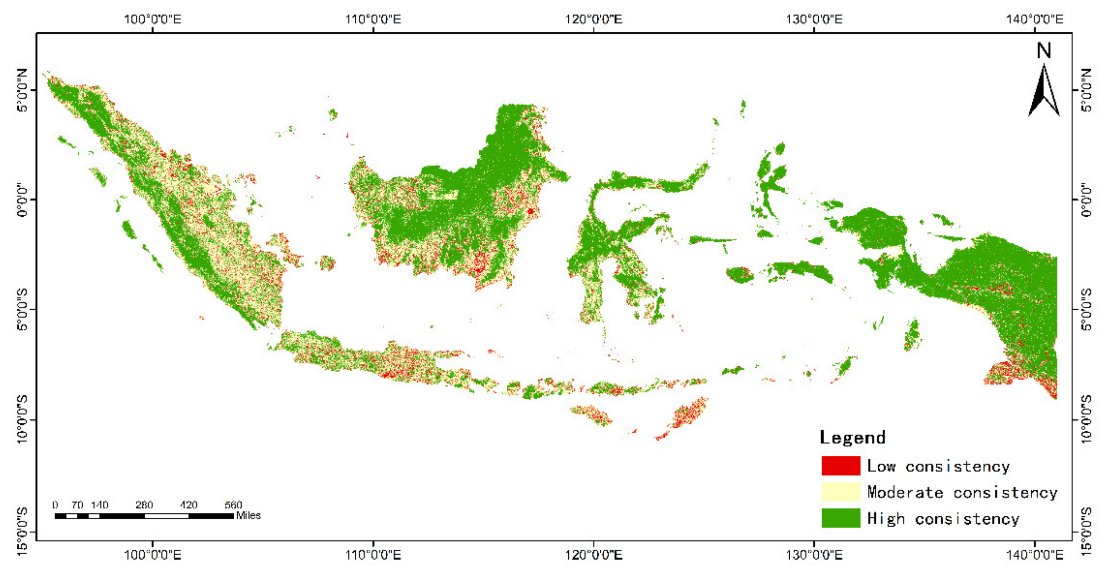
- High consistency: the coverage types of the three land cover products are exactly the same at the same pixel;
- (2)
- Moderate consistency: any two products have the same coverage type at the same pixel;
- (3)
- Low consistency: the three land cover products all have different coverage types at the same pixel.
3.3. Consistency Distribution of Topographic Features
3.4. Precision Evaluation Based on the Confusion Matrix
3.4.1. Relative Precision Evaluation
3.4.2. Absolute Precision Evaluation
4. Results and Analysis
4.1. Area Consistency Analysis
4.2. Consistency Analysis of Spatial Patterns
4.3. Spatial Consistency at Different Elevations
4.4. Precision Comparison of Different Products
4.4.1. Relative Precision
4.4.2. Absolute Precision
5. Discussion
6. Conclusions
Author Contributions
Funding
Acknowledgments
Conflicts of Interest
References
- Erb, K.H.; Luyssaert, S.; Meyfroidt, P.; Pongratz, J.; Don, A.; Kloster, S.; Kuemmerle, T.; Fetzel, T.; Fuchs, R.; Herold, M. Land management: Data availability and process understanding for global change studies. Glob. Chang. Biol. 2017, 23, 512–533. [Google Scholar] [CrossRef] [PubMed] [Green Version]
- Tolessa, T.; Senbeta, F.; Kidane, M. The impact of land use/land cover change on ecosystem services in the central highlands of Ethiopia. Ecosyst. Serv. 2017, 23, 47–54. [Google Scholar] [CrossRef]
- Franklin, J.; Serra-Diaz, J.M.; Syphard, A.D.; Regan, H.M. Big data for forecasting the impacts of global change on plant communities. Glob. Ecol. Biogeogr. 2017, 26, 6–17. [Google Scholar] [CrossRef]
- De Noblet-Ducoudré, N.; Boisier, J.-P.; Pitman, A.; Bonan, G.; Brovkin, V.; Cruz, F.; Delire, C.; Gayler, V.; Van den Hurk, B.; Lawrence, P. Determining robust impacts of land-use-induced land cover changes on surface climate over North America and Eurasia: Results from the first set of LUCID experiments. J. Clim. 2012, 25, 3261–3281. [Google Scholar] [CrossRef] [Green Version]
- Kayet, N.; Pathak, K.; Chakrabarty, A.; Sahoo, S. Spatial impact of land use/land cover change on surface temperature distribution in Saranda Forest, Jharkhand. Modeling Earth Syst. Environ. 2016, 2, 127. [Google Scholar] [CrossRef] [Green Version]
- Keola, S.; Andersson, M.; Hall, O. Monitoring economic development from space: Using nighttime light and land cover data to measure economic growth. World Dev. 2015, 66, 322–334. [Google Scholar] [CrossRef]
- Sterling, S.M.; Ducharne, A.; Polcher, J. The impact of global land-cover change on the terrestrial water cycle. Nat. Clim. Chang. 2013, 3, 385–390. [Google Scholar] [CrossRef]
- Cao, Q.; Yu, D.; Georgescu, M.; Han, Z.; Wu, J. Impacts of land use and land cover change on regional climate: A case study in the agro-pastoral transitional zone of China. Environ. Res. Lett. 2015, 10, 124025. [Google Scholar] [CrossRef]
- Hou, K.; Li, X.; Wang, J.J.; Zhang, J. An analysis of the impact on land use and ecological vulnerability of the policy of returning farmland to forest in Yan’an, China. Environ. Sci. Pollut. Res. 2016, 23, 4670–4680. [Google Scholar] [CrossRef]
- Salazar, A.; Baldi, G.; Hirota, M.; Syktus, J.; McAlpine, C. Land use and land cover change impacts on the regional climate of non-Amazonian South America: A review. Glob. Planet. Chang. 2015, 128, 103–119. [Google Scholar] [CrossRef]
- Watt, P.; Donoghue, D. Measuring forest structure with terrestrial laser scanning. Int. J. Remote Sens. 2005, 26, 1437–1446. [Google Scholar] [CrossRef]
- Almeida, C.A.d.; Coutinho, A.C.; Esquerdo, J.C.D.M.; Adami, M.; Venturieri, A.; Diniz, C.G.; Dessay, N.; Durieux, L.; Gomes, A.R. High spatial resolution land use and land cover mapping of the Brazilian Legal Amazon in 2008 using Landsat-5/TM and MODIS data. Acta Amaz. 2016, 46, 291–302. [Google Scholar] [CrossRef]
- Yifang, B.; Gong, P.; Gini, C. Global land cover mapping using Earth observation satellite data: Recent progresses and challenges. ISPRS J. Photogramm. Remote Sens. (Print) 2015, 103, 1–6. [Google Scholar]
- Laurin, G.V.; Liesenberg, V.; Chen, Q.; Guerriero, L.; Del Frate, F.; Bartolini, A.; Coomes, D.; Wilebore, B.; Lindsell, J.; Valentini, R. Optical and SAR sensor synergies for forest and land cover mapping in a tropical site in West Africa. Int. J. Appl. Earth Obs. Geoinf. 2013, 21, 7–16. [Google Scholar] [CrossRef]
- Abdikan, S.; Sanli, F.B.; Ustuner, M.; Calò, F. Land cover mapping using sentinel-1 SAR data. Int. Arch. Photogramm. Remote Sens. Spat. Inf. Sci. 2016, 41, 757. [Google Scholar] [CrossRef]
- Zhong, B.; Ma, P.; Nie, A.; Yang, A.; Yao, Y.; Lü, W.; Zhang, H.; Liu, Q. Land cover mapping using time series HJ-1/CCD data. Sci. China Earth Sci. 2014, 57, 1790–1799. [Google Scholar] [CrossRef]
- Zhang, X.; Liu, L.; Chen, X.; Xie, S.; Gao, Y. Fine land-cover mapping in china using landsat datacube and an operational speclib-based approach. Remote Sens. 2019, 11, 1056. [Google Scholar] [CrossRef] [Green Version]
- Chen, J.; Chen, J.; Liao, A.; Cao, X.; Chen, L.; Chen, X.; He, C.; Han, G.; Peng, S.; Lu, M. Global land cover mapping at 30 m resolution: A POK-based operational approach. ISPRS J. Photogramm. Remote Sens. 2015, 103, 7–27. [Google Scholar] [CrossRef] [Green Version]
- Gong, P.; Wang, J.; Yu, L.; Zhao, Y.; Zhao, Y.; Liang, L.; Niu, Z.; Huang, X.; Fu, H.; Liu, S. Finer resolution observation and monitoring of global land cover: First mapping results with Landsat TM and ETM+ data. Int. J. Remote Sens. 2013, 34, 2607–2654. [Google Scholar] [CrossRef] [Green Version]
- Friedl, M.A.; Sulla-Menashe, D.; Tan, B.; Schneider, A.; Ramankutty, N.; Sibley, A.; Huang, X. MODIS Collection 5 global land cover: Algorithm refinements and characterization of new datasets. Remote Sens. Environ. 2010, 114, 168–182. [Google Scholar] [CrossRef]
- Bartholomé, E.; Belward, A.S. GLC2000: A new approach to global land cover mapping from Earth observation data. Int. J. Remote Sens. 2005, 26, 1959–1977. [Google Scholar] [CrossRef]
- Hankui, K.; Zhang, D.; Roy, P. Using the 500 m MODIS land cover product to derive a consistent continental scale 30 m Landsat land cover classification. Remote Sens. Environ. 2017, 197, 15–34. [Google Scholar] [CrossRef]
- Yin, D.; Nickovic, S.; Sprigg, W.A. The impact of using different land cover data on wind-blown desert dust modeling results in the southwestern United States. Atmos. Environ. 2007, 41, 2214–2224. [Google Scholar] [CrossRef]
- Pérez-Hoyos, A.; García-Haro, F.J.; San-Miguel-Ayanz, J. A methodology to generate a synergetic land-cover map by fusion of different land-cover products. Int. J. Appl. Earth Obs. Geoinf. 2012, 19, 72–87. [Google Scholar] [CrossRef]
- Tsendbazar, N.; De Bruin, S.; Herold, M. Assessing global land cover reference datasets for different user communities. ISPRS J. Photogramm. Remote Sens. 2015, 103, 93–114. [Google Scholar] [CrossRef]
- Rendenieks, Z.; Tērauds, A.; Nikodemus, O.; Brūmelis, G. Comparison of input data with different spatial resolution in landscape pattern analysis–A case study from northern Latvia. Appl. Geogr. 2017, 83, 100–106. [Google Scholar] [CrossRef]
- Liang, D.; Zuo, Y.; Huang, L.; Zhao, J.; Teng, L.; Yang, F. Evaluation of the consistency of MODIS Land Cover Product (MCD12Q1) based on Chinese 30 m GlobeLand30 datasets: A case study in Anhui Province, China. ISPRS Int. J. Geo-Inf. 2015, 4, 2519–2541. [Google Scholar] [CrossRef] [Green Version]
- Song, H.; Zhang, X. Precision analysis and validation of multi-sources landcover products derived from remote sensing in China. Trans. Chin. Soc. Agric. Eng. 2012, 28, 207–214. [Google Scholar]
- Song, H.; Zhang, X. Exploratory analysis of category accuracy for multi-sources land cover products. Res. Soil Water Conserv. 2015, 22, 36–41. [Google Scholar]
- Kuenzer, C.; Leinenkugel, P.; Vollmuth, M.; Dech, S. Comparing global land-cover products–implications for geoscience applications: An investigation for the trans-boundary Mekong Basin. Int. J. Remote Sens. 2014, 35, 2752–2779. [Google Scholar] [CrossRef] [Green Version]
- Liang, L.; Liu, Q.; Liu, G.; Li, H.; Huang, C. Accuracy Evaluation and Consistency Analysis of Four Global Land Cover Products in the Arctic Region. Remote Sens. 2019, 11, 1396. [Google Scholar] [CrossRef] [Green Version]
- Kang, J.; Sui, L.; Yang, X.; Wang, Z.; Huang, C.; Wang, J. Spatial Pattern Consistency among DifferentRemote-Sensing Land Cover Datasets: A Case Studyin Northern Laos. ISPRS Int. J. Geo-Inf. 2019, 8, 201. [Google Scholar] [CrossRef] [Green Version]
- Giri, C.; Zhu, Z.; Reed, B. A comparative analysis of the Global Land Cover 2000 and MODIS land cover data sets. Remote Sens. of Environ. 2005, 94, 123–132. [Google Scholar] [CrossRef]
- Herold, M.; Mayaux, P.; Woodcock, C.E.; Baccini, A.; Schmullius, C. Some challenges in global land cover mapping: An assessment of agreement and accuracy in existing 1 km datasets. Remote Sens. Environ. 2008, 112, 2538–2556. [Google Scholar] [CrossRef]
- Hua, T.; Zhao, W.; Liu, Y.; Wang, S.; Yang, S. Spatial consistency assessments for global land-cover datasets: A comparison among GLC2000, CCI LC, MCD12, GLOBCOVER and GLCNMO. Remote Sens. 2018, 10, 1846. [Google Scholar] [CrossRef] [Green Version]
- Zeyuan, X.; Qinghui, L.; Zhonglin, X. Consistency of Land Cover Data Derived from Remote Sensing in Xinjiang. J. Geo-Inf. Sci. 2019, 21, 127–136. [Google Scholar]
- Qi, W.; Yang, X.; Li, Z.; Li, Y.; Yang, F. Correlation of topography and land use type distribution: Taking Jinggangshan region in Jiangxi Province for an example. Remote Sens. Inf. 2018, 33, 64–71. [Google Scholar]
- Yi, L.; Zhang, G. Object-oriented remote sensing imagery classification accuracy assessment based on confusion matrix. In Proceedings of the 2012 20th International Conference on Geoinformatics, Hong Kong, China, 15–17 June 2012. [Google Scholar]
- Ismail, M.H.; Jusoff, K. Satellite data classification accuracy assessment based from reference dataset. Int. J. Comput. Inf. Sci. Eng. 2008, 2, 96–102. [Google Scholar]
- Hsiao, L.H.; Cheng, K.S. Assessing uncertainties in accuracy of landuse classification using remote sensing images. ISPRS Int. Arch. Photogramm. Remote Sens. Spat. Inf. Sci. 2013, 40, 19–23. [Google Scholar] [CrossRef] [Green Version]
- Niu, Z.; Shan, Y.; Gong, P. Accuracy evaluation of two global land cover data sets over wetlands of China. In Proceedings of the XXII Congress of the International Society for Photogrammetry and Remote SensingThe XXII Congress of the International Society for Photogrammetry and Remote Sensing, Melbourne, Australia, 25 August–1 September 2012. [Google Scholar] [CrossRef] [Green Version]
- Liu, Q.; Zhang, Y.; Liu, L.; Li, L.; Qi, W. Accuracy evaluation of the seven land cover data in Qiangtang Plateau. Geogr. Res. 2017, 36, 2061–2074. [Google Scholar]
- Zhao, Y.; Gong, P.; Yu, L.; Hu, L.; Li, X.; Li, C.; Zhang, H.; Zheng, Y.; Wang, J.; Zhao, Y. Towards a common validation sample set for global land-cover mapping. Int. J. Remote Sens. 2014, 35, 4795–4814. [Google Scholar] [CrossRef]
- Huang, Y.; Liao, S. Regional accuracy assessments of the first global land coverdataset at 30-meter resolution: A case study of Henan province. Geogr. Res. 2016, 35, 1433–1446. [Google Scholar]
- Fritz, S.; McCallum, I.; Schill, C.; Perger, C.; See, L.; Schepaschenko, D.; Velde, M.v.d.; Kraxner, F.; Obersteiner, M. Geo-Wiki: An online platform for improving global land cover. Environ. Model. Softw. 2012, 31, 110–123. [Google Scholar] [CrossRef]
- Djaenudin, D.; Oktaviani, R.; Hartoyo, S.; Dwiprabowo, H. Modelling of land allocation behavior in Indonesia. Procedia Environ. Sci. 2016, 33, 78–86. [Google Scholar] [CrossRef] [Green Version]
- Congalton, R.G.; Gu, J.; Yadav, K.; Thenkabail, P.; Ozdogan, M. Global land cover mapping: A review and uncertainty analysis. Remote Sens. 2014, 6, 12070–12093. [Google Scholar] [CrossRef] [Green Version]
- Li, C.; Wang, J.; Wang, L.; Hu, L.; Gong, P. Comparison of classification algorithms and training sample sizes in urban land classification with Landsat thematic mapper imagery. Remote Sens. 2014, 6, 964–983. [Google Scholar] [CrossRef] [Green Version]
- Feng, D.; Zhao, Y.; Yu, L.; Li, C.; Wang, J.; Clinton, N.; Bai, Y.; Belward, A.; Zhu, Z.; Gong, P. Circa 2014 African land-cover maps compatible with FROM-GLC and GLC2000 classification schemes based on multi-seasonal Landsat data. Int. J. Remote Sens. 2016, 37, 4648–4664. [Google Scholar] [CrossRef]
- Li, C.; Gong, P.; Wang, J.; Zhu, Z.; Biging, G.S.; Yuan, C.; Hu, T.; Zhang, H.; Wang, Q.; Li, X. The first all-season sample set for mapping global land cover with Landsat-8 data. Sci. Bull. 2017, 62, 508–515. [Google Scholar] [CrossRef] [Green Version]
- Defourny, P.; Kirches, G.; Brockmann, C.; Boettcher, M.; Peters, M.; Bontemps, S.; Lamarche, C.; Schlerf, M.; Santoro, M. Land Cover CCI: Product User Guide Version 2. 2018. Available online: https://www.esa-landcover-cci.org/?q=webfm_send/84 (accessed on 4 May 2019).

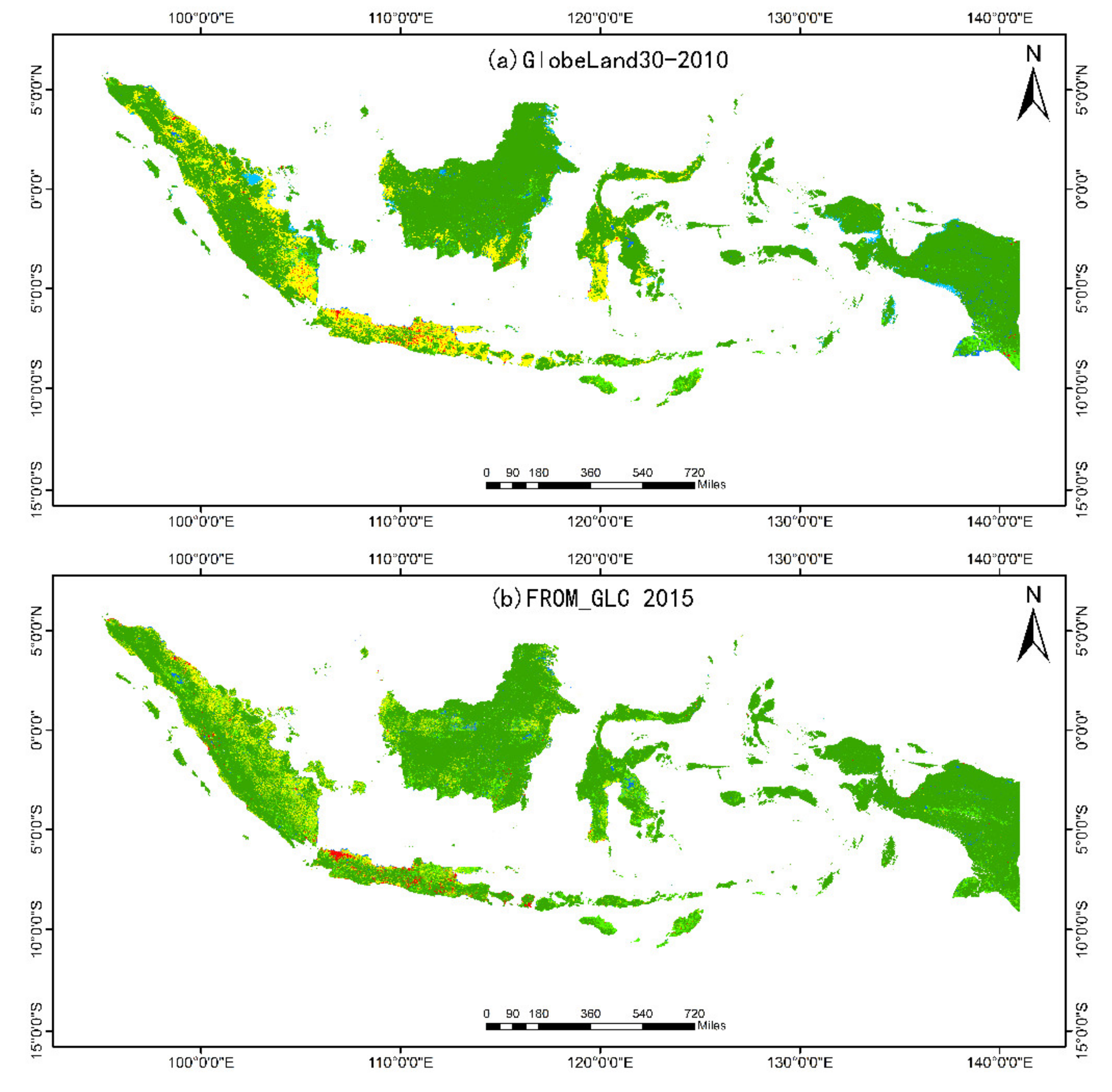
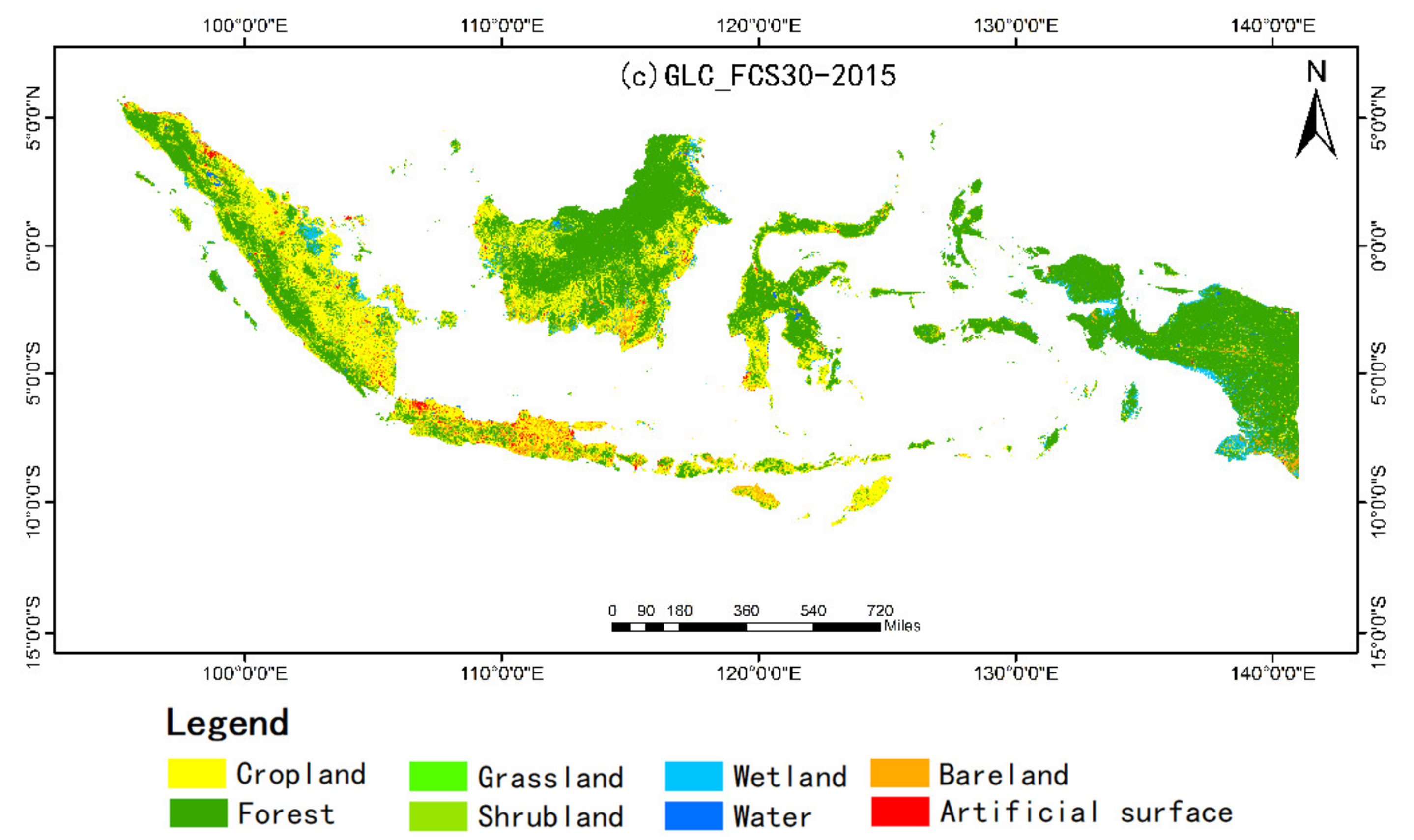
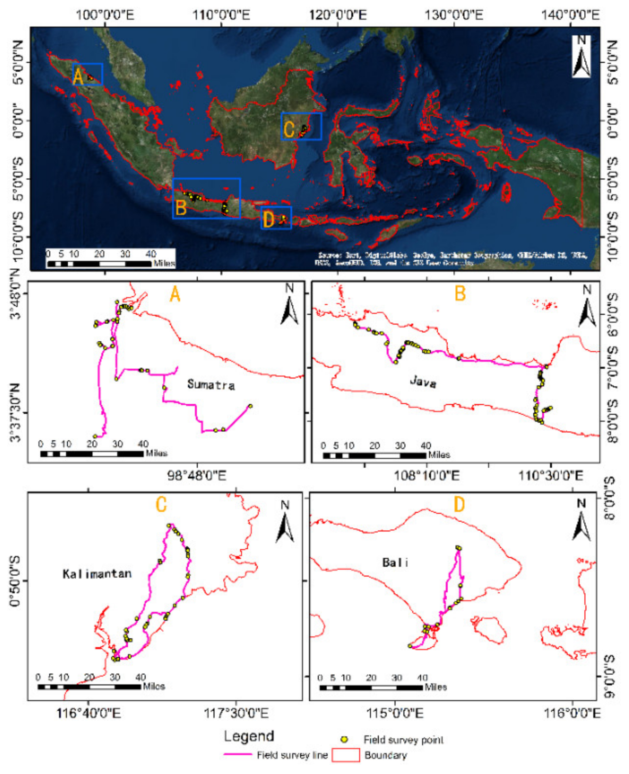
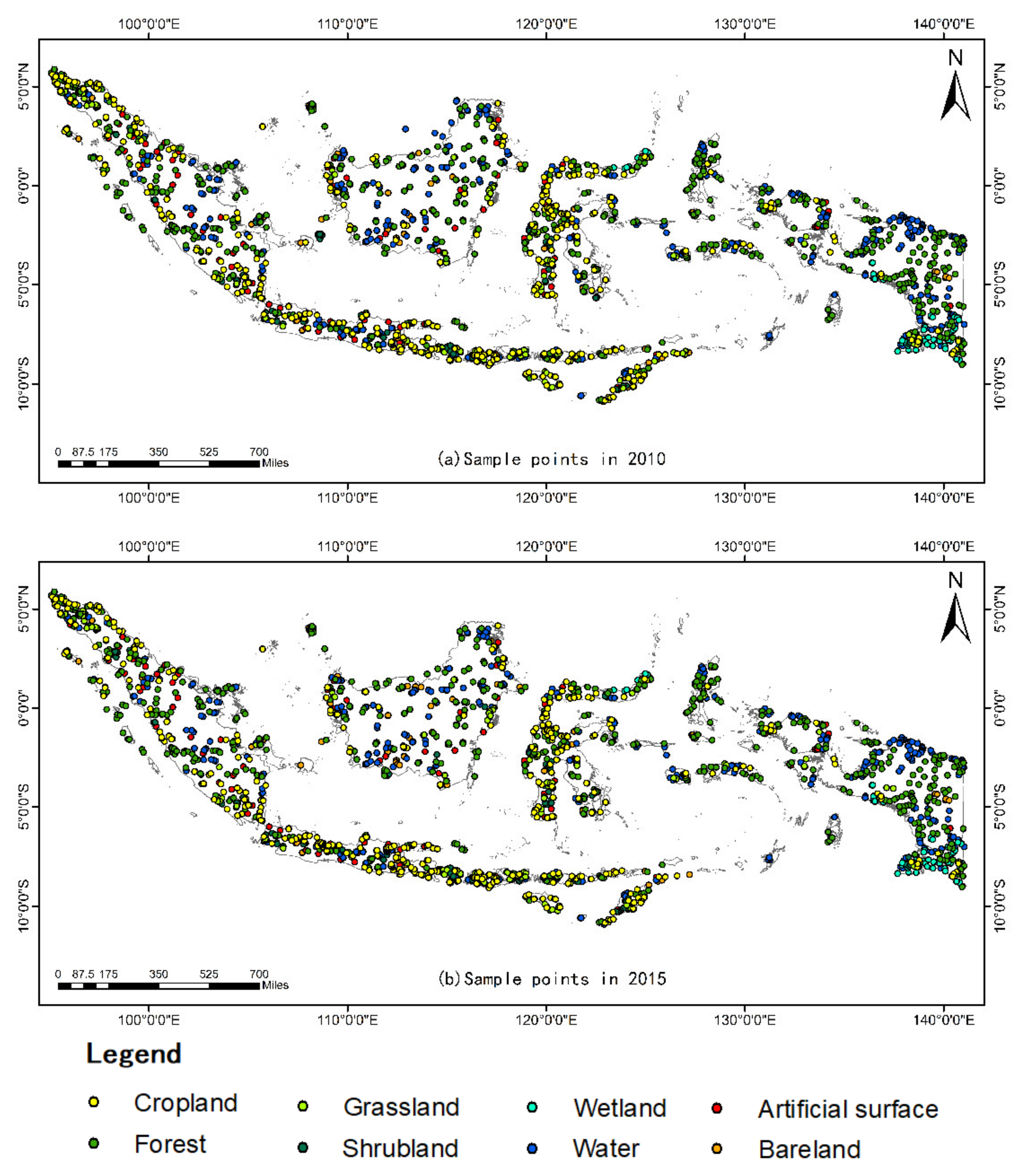
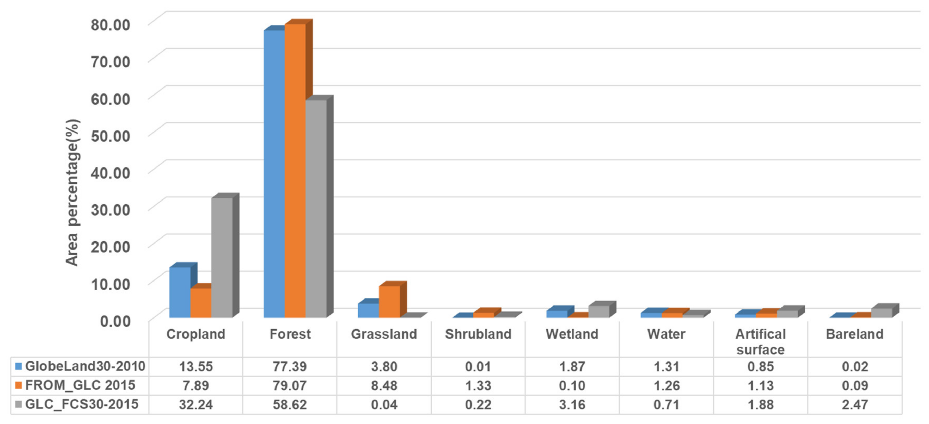
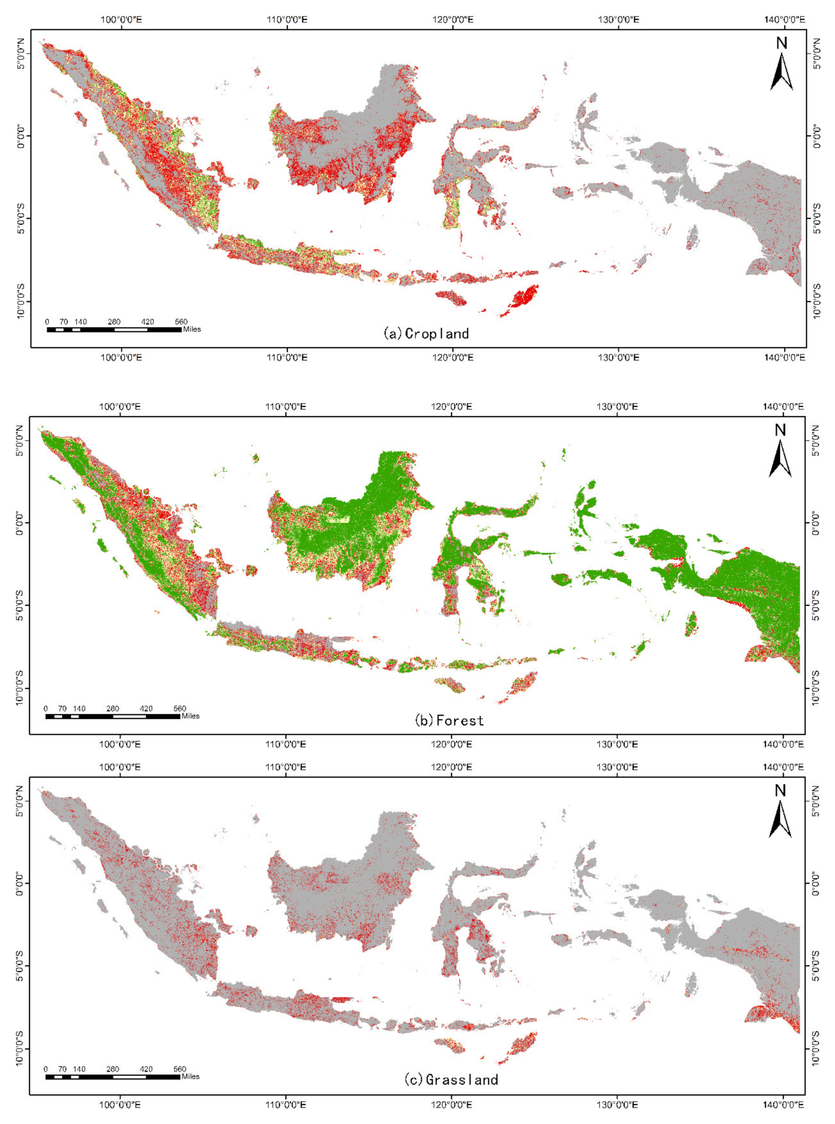
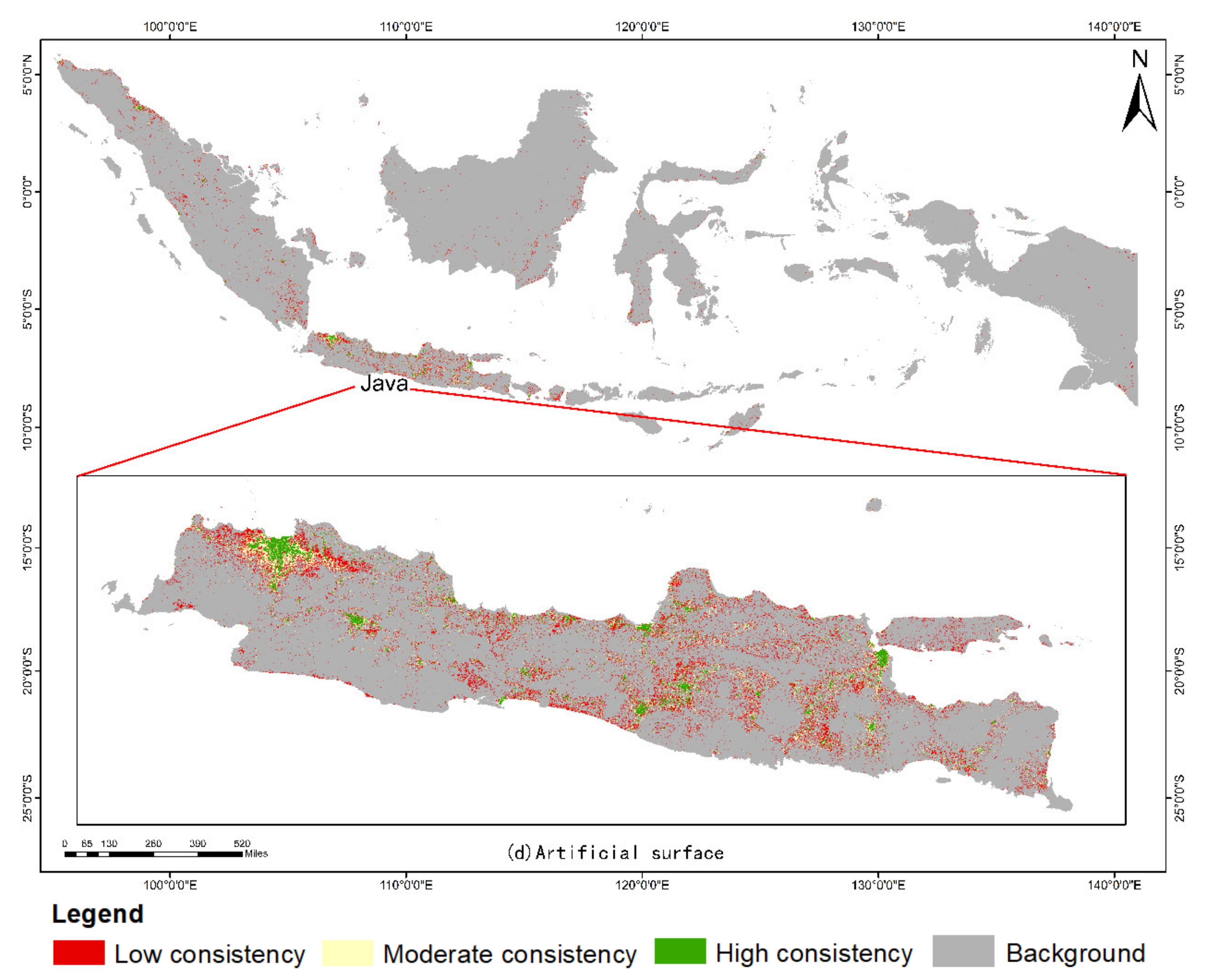
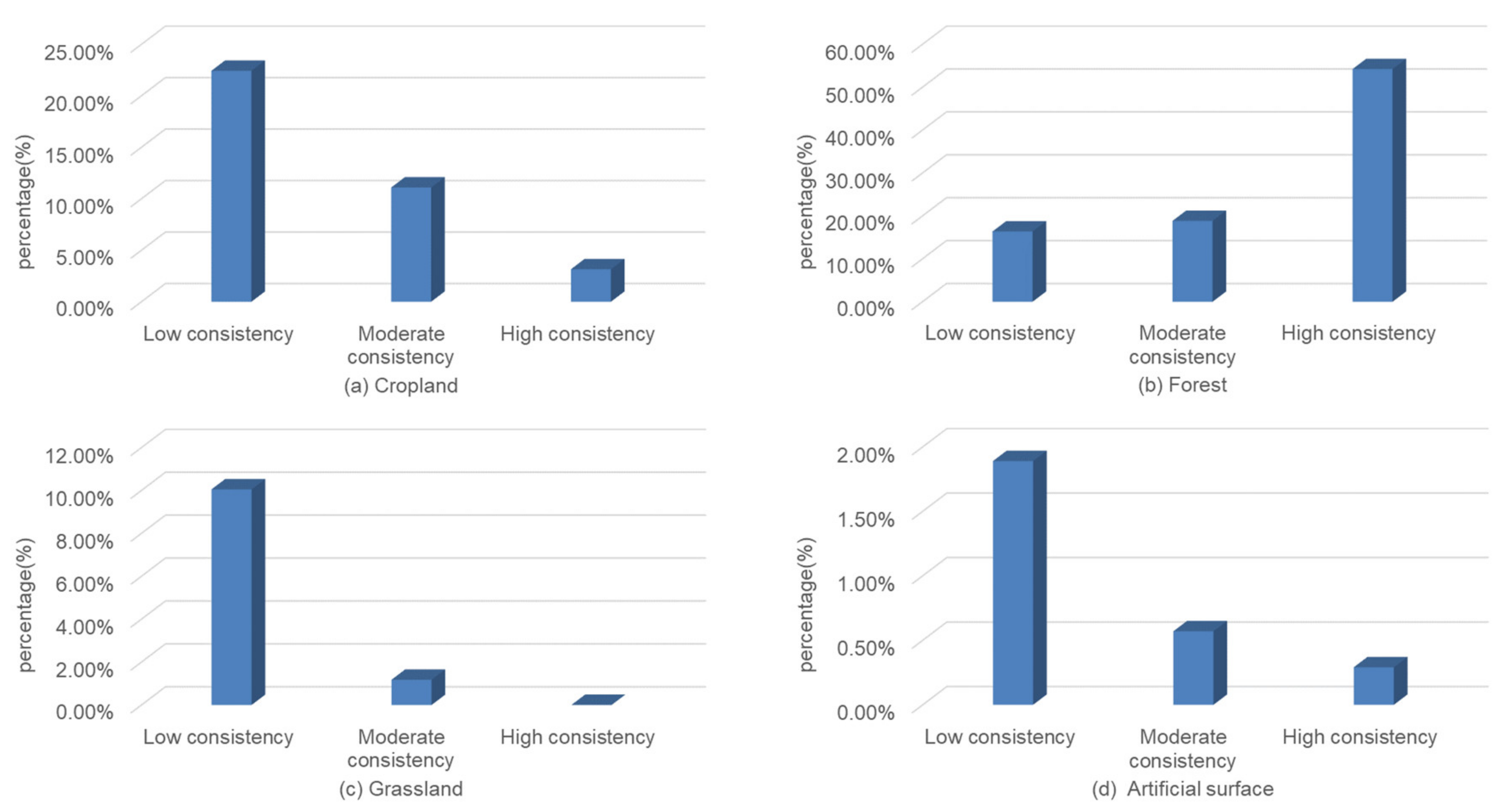




| Name | Resolution (m) | Number of Categories | Time | Method | Overall Accuracy (%) | Production Institution | Sensor | Satellite | Area |
|---|---|---|---|---|---|---|---|---|---|
| GlobeLand30-2010 | 30 | 10 | 2010 | POK (based on pixels, objects, and knowledge rules) | 80.3 | National Geomatics Center of China | TM/ETM+ | Landsat/ HJ-1A/B | Global |
| FROM_GLC2015 | 30 | 26 | 2015 | Random forest | 77.3 | Tsinghua University | TM/ETM+/ OLI | Landsat | Global |
| GLC_FCS30-2015 | 30 | 30 | 2015 | Random forest | 81.4 | Institute of Remote Sensing and Digital Earth, Chinese Academy of Sciences | OLI | Landsat | Global |
| Code | GlobeLand30-2010 | Code | FROM_GLC2015 | Code | GLC_FCS30-2015 |
|---|---|---|---|---|---|
| 10 | Cropland | 10 | Cropland | 10 | Rainfed cropland |
| 20 | Forest | 11 | Rice paddy | 11 | Herbaceous cover |
| 30 | Grassland | 12 | Greenhouse | 12 | Tree or shrub cover (orchard) |
| 40 | Shrubland | 13 | Other | 20 | Irrigated cropland |
| 50 | Wetland | 14 | Orchard | 50 | Evergreen broadleaf forest |
| 60 | Water body | 15 | Bare farmland | 60 | Deciduous broadleaf forest |
| 70 | Tundra | 20 | Forest | 61 | Open deciduous broadleaf forest (0.15 < fc < 0.4) |
| 80 | Artificial surface | 21 | Broadleaf, leaf-on | 62 | Closed deciduous broadleaf forest (fc > 0.4) |
| 90 | Bareland | 22 | Broadleaf, leaf-off | 70 | Evergreen needleleaf forest |
| 100 | Permanent snow and ice | 23 | Needleleaf, leaf-on | 71 | Open evergreen needleleaf forest (0.15 < fc < 0.4) |
| 24 | Needleleaf, leaf-off | 72 | Closed evergreen needleleaf forest (fc > 0.4) | ||
| 25 | Mixed leaf, leaf-on | 80 | Deciduous needleleaf forest | ||
| 26 | Mixed leaf, leaf-off | 81 | Open deciduous needleleaf forest (0.15 < fc < 0.4) | ||
| 30 | Grassland | 82 | Closed deciduous needleleaf forest (fc > 0.4) | ||
| 31 | Pasture | 90 | Mixed-leaf forest (broadleaf and needleleaf) | ||
| 32 | Natural grassland | 120 | Shrubland | ||
| 33 | Grassland, leaf-off | 121 | Evergreen shrubland | ||
| 40 | Shrubland | 122 | Deciduous shrubland | ||
| 41 | Shrubland, leaf-on | 130 | Grassland | ||
| 42 | Shrubland, leaf-off | 140 | Lichens and mosses | ||
| 50 | Wetland | 150 | Sparse vegetation (fc < 0.15) | ||
| 51 | Marshland | 152 | Sparse shrubland (fc < 0.15) | ||
| 52 | Mudflat | 153 | Sparse herbaceous (fc < 0.15) | ||
| 53 | Marshland, leaf-off | 180 | Wetland | ||
| 60 | Water | 190 | Impervious | ||
| 70 | Tundra | 200 | Bare area | ||
| 71 | Scrub and brush tundra | 201 | Consolidated bare area | ||
| 72 | Herbaceous tundra | 202 | Unconsolidated bare area | ||
| 80 | Impervious surface | 210 | Water body | ||
| 90 | Bareland | 220 | Permanent ice and snow | ||
| 100 | Snow/Ice | 250 | Filled value | ||
| 101 | Snow | ||||
| 102 | Ice | ||||
| 120 | Cloud |
| Type | GlobeLand30-2010 | FROM_GLC2015 | GLC_FCS30-2015 |
|---|---|---|---|
| 10 Cropland | 10 | 11,13,14,15 | 10,11,12,20 |
| 20 Forest | 20 | 21,22,23,24,25 | 50,60,62,70,80 |
| 30 Grassland | 30 | 32,33 | 130 |
| 40 Shrubland | 40 | 41,42 | 120,121,122 |
| 50 Wetland | 50 | 51,52,53 | 180 |
| 60 Water | 60 | 60 | 210 |
| 80 Artificial surface | 80 | 80 | 190 |
| 90 Bareland | 90 | 90 | 150,200 |
| Grade | 1 | 2 | 3 | 4 | 5 |
|---|---|---|---|---|---|
| Elevation (m) | <200 | 200–500 | 500–1000 | 1000–2000 | >2000 |
| Product | GlobeLand30-2010 | FROM_GLC2015 | GLC_FCS30-2015 |
|---|---|---|---|
| GlobeLand30-2010 | 1.00 | 0.99 | 0.93 |
| FROM_GLC2015 | 0.99 | 1.00 | 0.89 |
| GLC_FCS30-2015 | 0.93 | 0.89 | 1.00 |
| Reference Data | ||||||||||
|---|---|---|---|---|---|---|---|---|---|---|
| Evaluation data | Type | 10 | 20 | 30 | 40 | 50 | 60 | 80 | 90 | UA (%) |
| 10 | 63,765,335 | 82,319,844 | 6,118,721 | 1151 | 2,239,850 | 2,376,296 | 3,453,694 | 41,433 | 39.78 | |
| 20 | 145,564,881 | 1,373,581,262 | 49,231,240 | 5106 | 24,370,319 | 14,443,112 | 7,324,310 | 102,272 | 85.07 | |
| 30 | 44,575,022 | 102,117,491 | 16,319,969 | 12,836 | 1,889,055 | 2,687,942 | 2,468,208 | 65,208 | 9.59 | |
| 40 | 7,100,847 | 16,508,690 | 2,417,365 | 686 | 266,216 | 348,253 | 459,575 | 7977 | 0.00 | |
| 50 | 622,442 | 841,257 | 108,738 | 9 | 138,805 | 79,017 | 30,976 | 1070 | 7.62 | |
| 60 | 4,569,142 | 13,144,409 | 955,971 | 48 | 1,504,843 | 4,062,357 | 261,072 | 6504 | 16.58 | |
| 80 | 13,422,930 | 4,631,981 | 609,448 | 1936 | 110,888 | 375,785 | 3,470,854 | 3861 | 15.34 | |
| 90 | 65,905 | 1,705,584 | 42,124 | 0 | 9886 | 27,664 | 13,266 | 168 | 0.01 | |
| PA (%) | 22.80 | 86.13 | 21.53 | 3.15 | 0.46 | 16.65 | 19.85 | 0.07 | ||
| OA (%) | 72.24 | |||||||||
| Kappa | 0.22 | |||||||||
| Reference Data | ||||||||||
|---|---|---|---|---|---|---|---|---|---|---|
| Evaluation data | Type | 10 | 20 | 30 | 40 | 50 | 60 | 80 | 90 | UA (%) |
| 10 | 136,155,874 | 17,841,006 | 7289 | 541,272 | 1,792,536 | 544,446 | 6,761,429 | 3,147,258 | 81.63 | |
| 20 | 393,567,421 | 1,186,613,850 | 116,801 | 2,788,981 | 56,464,435 | 975,728 | 7,536,838 | 22,571,822 | 71.03 | |
| 30 | 115,951,879 | 21,723,043 | 641,586 | 992,341 | 5,185,234 | 710,482 | 11,035,484 | 22,462,783 | 0.36 | |
| 40 | 16,181,077 | 6,198,069 | 19,559 | 125,207 | 1,183,178 | 44,034 | 1,082,450 | 3,192,584 | 0.45 | |
| 50 | 1,180,904 | 289,290 | 1120 | 18,980 | 293,114 | 92,955 | 41,846 | 74,183 | 14.71 | |
| 60 | 7,542,240 | 4,372,744 | 45,605 | 150,341 | 1,411,568 | 12,313,442 | 317,371 | 183,700 | 46.75 | |
| 80 | 10,098,892 | 372,187 | 27,295 | 25,016 | 95,181 | 87,961 | 12,771,650 | 610,762 | 53.02 | |
| 90 | 496,409 | 1,116,041 | 15,672 | 5873 | 12,790 | 11,733 | 227,407 | 53,583 | 2.76 | |
| PA (%) | 19.99 | 95.81 | 73.33 | 2.70 | 0.44 | 83.31 | 32.11 | 0.10 | ||
| OA (%) | 64.28 | |||||||||
| Kappa | 0.29 | |||||||||
| Reference Data | ||||||||||
|---|---|---|---|---|---|---|---|---|---|---|
| Evaluation data | Type | 10 | 20 | 30 | 40 | 50 | 60 | 80 | 90 | UA (%) |
| 10 | 191,298,294 | 400,714,223 | 33,572,497 | 18,719 | 7,580,681 | 8,267,857 | 10,263,784 | 144,523 | 29.35 | |
| 20 | 49,454,791 | 1,117,265,055 | 23,515,060 | 610 | 7,639,140 | 8,253,571 | 1,919,939 | 51,036 | 92.48 | |
| 30 | 3483 | 781,586 | 83,371 | 0 | 1712 | 3796 | 318 | 91 | 9.53 | |
| 40 | 320,146 | 3,428,270 | 552,875 | 0 | 95,032 | 73,608 | 10,913 | 2035 | 0.00 | |
| 50 | 3,959,528 | 29,880,664 | 6,070,136 | 14 | 13,438,485 | 2,595,123 | 195,365 | 15,380 | 23.93 | |
| 60 | 2,720,871 | 6,033,115 | 519,312 | 25 | 1,009,879 | 3,447,387 | 118,337 | 2199 | 24.89 | |
| 80 | 20,053,445 | 10,881,463 | 1,068,983 | 0 | 275,915 | 817,506 | 4,336,331 | 2532 | 11.58 | |
| 90 | 12,011,530 | 26,485,064 | 9,972,700 | 2642 | 395,965 | 827,048 | 639,151 | 10,876 | 0.02 | |
| PA (%) | 68.36 | 70.03 | 0.11 | 0.00 | 44.15 | 14.20 | 24.80 | 4.76 | ||
| OA (%) | 65.74 | |||||||||
| Kappa | 0.29 | |||||||||
| Reference Data | ||||||||||
|---|---|---|---|---|---|---|---|---|---|---|
| Evaluation data | Type | 10 | 20 | 30 | 40 | 50 | 60 | 80 | 90 | UA (%) |
| 10 | 475 | 96 | 120 | 72 | 12 | 126 | 1 | 71 | 48.82 | |
| 20 | 14 | 555 | 7 | 64 | 2 | 24 | 0 | 3 | 82.96 | |
| 30 | 0 | 0 | 7 | 0 | 0 | 0 | 0 | 4 | 63.64 | |
| 40 | 8 | 1 | 1 | 10 | 0 | 5 | 0 | 1 | 38.46 | |
| 50 | 9 | 14 | 0 | 0 | 33 | 16 | 0 | 2 | 44.59 | |
| 60 | 5 | 0 | 0 | 0 | 1 | 260 | 0 | 0 | 97.74 | |
| 80 | 24 | 0 | 1 | 0 | 0 | 0 | 106 | 13 | 73.61 | |
| 90 | 22 | 1 | 21 | 0 | 5 | 1 | 0 | 16 | 24.24 | |
| PA (%) | 85.28 | 83.21 | 4.46 | 6.85 | 62.26 | 60.19 | 99.07 | 14.55 | ||
| OA (%) | 65.59 | |||||||||
| Kappa | 0.55 | |||||||||
| Reference Data | ||||||||||
|---|---|---|---|---|---|---|---|---|---|---|
| Evaluation data | Type | 10 | 20 | 30 | 40 | 50 | 60 | 80 | 90 | UA (%) |
| 10 | 335 | 16 | 42 | 60 | 2 | 18 | 17 | 15 | 66.34 | |
| 20 | 147 | 633 | 73 | 43 | 16 | 135 | 5 | 64 | 56.72 | |
| 30 | 35 | 12 | 36 | 6 | 19 | 22 | 0 | 25 | 23.23 | |
| 40 | 0 | 0 | 0 | 26 | 0 | 0 | 0 | 0 | 100.00 | |
| 50 | 5 | 4 | 0 | 0 | 7 | 14 | 0 | 1 | 22.58 | |
| 60 | 4 | 1 | 1 | 0 | 9 | 228 | 1 | 0 | 93.44 | |
| 80 | 14 | 0 | 2 | 7 | 0 | 2 | 84 | 2 | 75.68 | |
| 90 | 0 | 0 | 0 | 0 | 0 | 0 | 0 | 0 | 0.00 | |
| PA (%) | 62.04 | 95.05 | 23.38 | 18.31 | 13.21 | 54.42 | 78.50 | 0.00 | ||
| OA (%) | 61.65 | |||||||||
| Kappa | 0.49 | |||||||||
| Reference Data | ||||||||||
|---|---|---|---|---|---|---|---|---|---|---|
| Evaluation data | Type | 10 | 20 | 30 | 40 | 50 | 60 | 80 | 90 | UA (%) |
| 10 | 182 | 16 | 8 | 4 | 0 | 17 | 1 | 13 | 75.52 | |
| 20 | 156 | 642 | 73 | 127 | 29 | 64 | 4 | 9 | 58.15 | |
| 30 | 151 | 6 | 63 | 9 | 19 | 40 | 14 | 51 | 17.85 | |
| 40 | 6 | 0 | 7 | 6 | 3 | 1 | 0 | 2 | 24.00 | |
| 50 | 0 | 0 | 0 | 0 | 0 | 2 | 0 | 0 | 0.00 | |
| 60 | 10 | 2 | 1 | 0 | 5 | 296 | 1 | 14 | 89.97 | |
| 80 | 51 | 1 | 5 | 0 | 0 | 12 | 87 | 10 | 52.41 | |
| 90 | 0 | 0 | 0 | 0 | 0 | 0 | 0 | 12 | 100.00 | |
| PA (%) | 32.73 | 96.25 | 40.13 | 4.11 | 0.00 | 68.52 | 81.31 | 10.81 | ||
| OA (%) | 57.71 | |||||||||
| Kappa | 0.46 | |||||||||
© 2020 by the authors. Licensee MDPI, Basel, Switzerland. This article is an open access article distributed under the terms and conditions of the Creative Commons Attribution (CC BY) license (http://creativecommons.org/licenses/by/4.0/).
Share and Cite
Kang, J.; Wang, Z.; Sui, L.; Yang, X.; Ma, Y.; Wang, J. Consistency Analysis of Remote Sensing Land Cover Products in the Tropical Rainforest Climate Region: A Case Study of Indonesia. Remote Sens. 2020, 12, 1410. https://doi.org/10.3390/rs12091410
Kang J, Wang Z, Sui L, Yang X, Ma Y, Wang J. Consistency Analysis of Remote Sensing Land Cover Products in the Tropical Rainforest Climate Region: A Case Study of Indonesia. Remote Sensing. 2020; 12(9):1410. https://doi.org/10.3390/rs12091410
Chicago/Turabian StyleKang, Junmei, Zhihua Wang, Lichun Sui, Xiaomei Yang, Yuanzheng Ma, and Jun Wang. 2020. "Consistency Analysis of Remote Sensing Land Cover Products in the Tropical Rainforest Climate Region: A Case Study of Indonesia" Remote Sensing 12, no. 9: 1410. https://doi.org/10.3390/rs12091410
APA StyleKang, J., Wang, Z., Sui, L., Yang, X., Ma, Y., & Wang, J. (2020). Consistency Analysis of Remote Sensing Land Cover Products in the Tropical Rainforest Climate Region: A Case Study of Indonesia. Remote Sensing, 12(9), 1410. https://doi.org/10.3390/rs12091410


