
Using High-Spatial Resolution UAV-Derived Data to Evaluate Vegetation and Geomorphological Changes on a Dune Field Involved in a Restoration Endeavour


Abstract
1. Introduction
2. Study Area
3. Materials and Methods
3.1. Field Surveys
3.2. Post Processing and Analysis
3.2.1. RGB Data Analysis
3.2.2. Morphological Analysis and Error Calculation
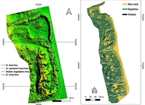
- The Dune Foot Line (DFL) represents the most seaward limit of the dune and morphologically it is identified as an abrupt change in slope over a relatively short distance [76]. According to several authors [77,78], calculating DSM surface slopes and overlapping elevation contour lines to the DSM, is a reliable method to understand where the abrupt change of slope is located, in order to properly identify the dune foot line (Figure 4).
- The Dune Crest Line (DCL) is identified by “the highest-elevation peak landward of the shoreline and within a user-defined beach width” [79], thus dune crest position can be identified as the highest elevation point closest to the shoreline (Figure 5): 0.1 m overlapped contours to the elevation model proved to be very well suited to accomplish this task.
- The Dune seaward Crest Line (DsCL) refers to the morphology of the northern part of the system where in the last 10 years beach management has modified the dune morphology and an incipient foredune has formed in the seaward part of the dune system. Due to the DsCL morphology, the same methodology used to identify the DCL can be applied (Figure 5).
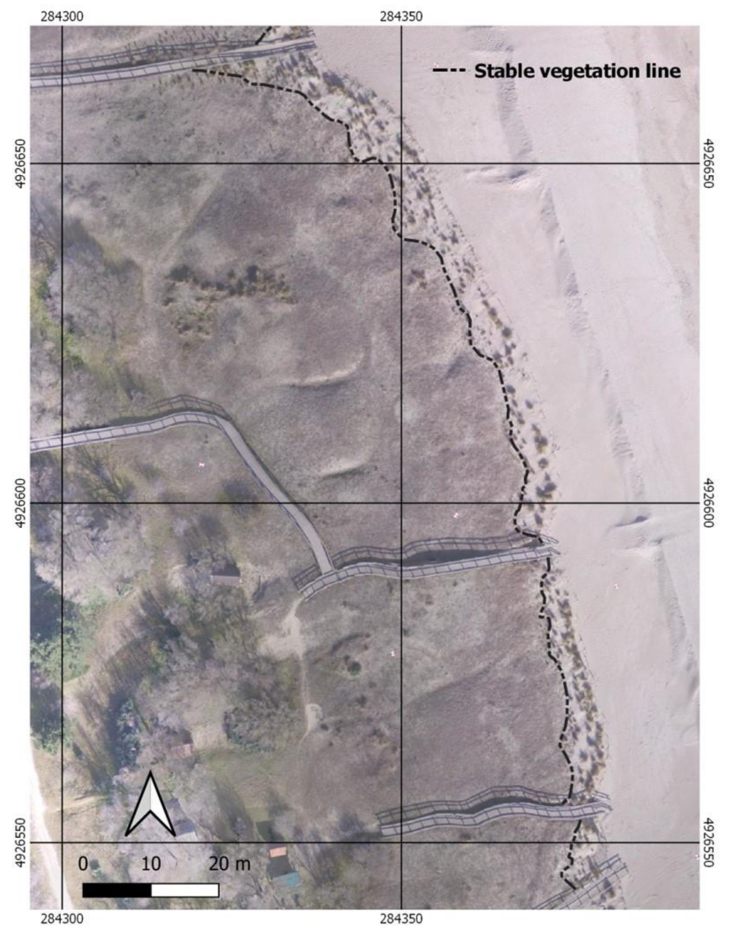
- The Stable Vegetation line (SVL) is basically determined by the borders of Agropyretum and Ammophyletum. At these latitudes the two communities often merge [44] being both perennial herbaceous vegetation typical of embryonal and white dunes of the Mediterranean [80]. This line was traced from the high spatial resolution (0.05 m) orthomosaics (Figure 6).
- Net Shoreline Movement (NSM): distance between the oldest and the most recent linear element, for each transect.
- End Point Rate (EPR): rate calculated considering the distance covered by each feature in relation to the time interval between the oldest and the most recent one.
- Confidence of End Point Rate (ECI or EPRunc in newer versions of DSAS): this index takes into consideration the uncertainty of lines (accuracy error) as a factor for calculating the EPR confidence.
- Pixel error: the spatial resolution of the digital model or image;
- GCP error (Figure 2): calculated by Photoscan software, during the model reconstruction process;
- GPS error: estimated as a maximum of 0.05 m, applying RTK technology;
- Digitizing error: calculated by delineating the same feature several times (in this case four) on the same orthomosaic and calculating the Root Mean Square Error of position residuals at regular intervals for that feature [67,68,69]. The position residuals between each pair of morphological lines were calculated by the “spatial adjustment” tool of Arcmap 10.1 (ESRI). Table 3 reports RMSE values calculated for each morphological feature; for each comparison, the highest value was taken as the uncertainty value.
4. Results
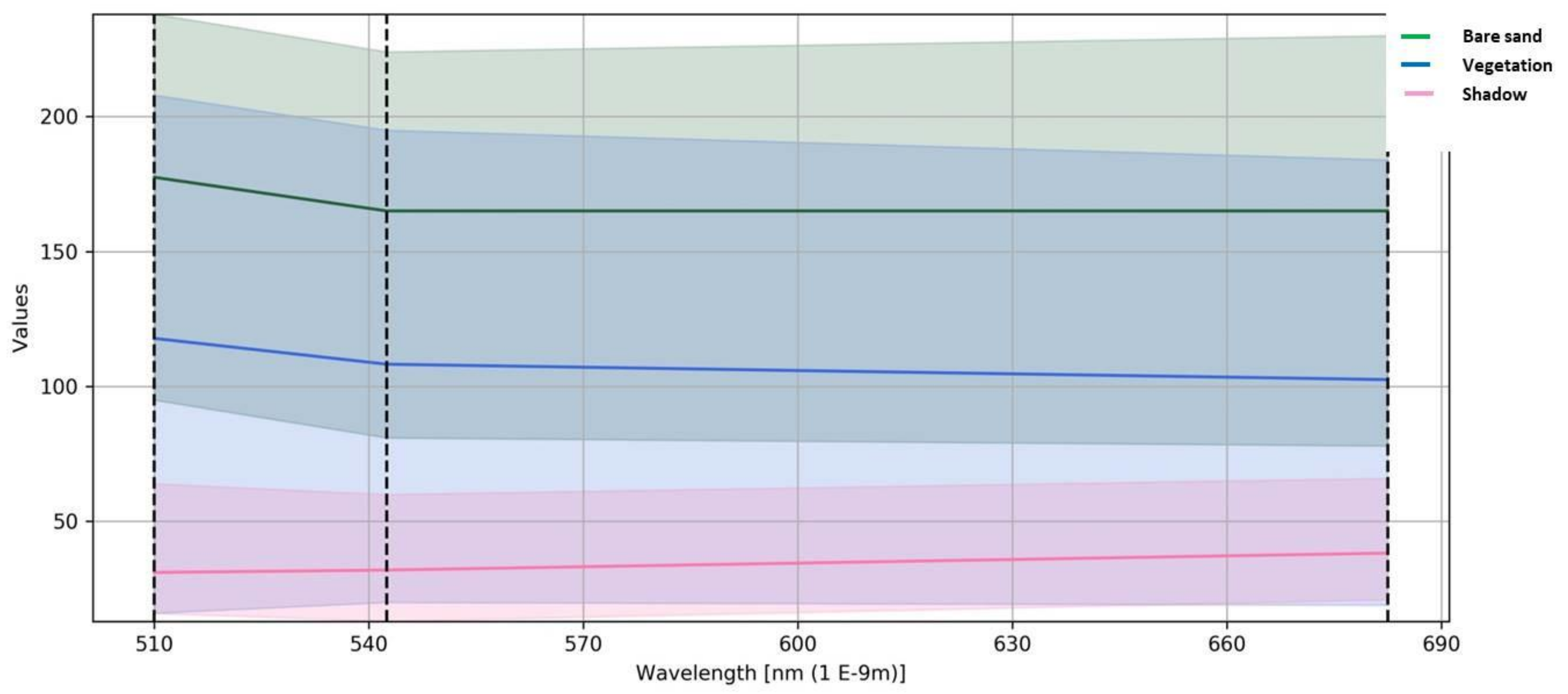
4.1. Semi-Automatic Classification Results
4.2. Error Calculation and Morphological Analysis Results
5. Discussion
5.1. Error Analysis of Geomorphic Line Features
5.2. Vegetation and Geomorphic Analyses
6. Conclusions
Author Contributions
Funding
Institutional Review Board Statement
Informed Consent Statement
Data Availability Statement
Acknowledgments
Conflicts of Interest
References
- Martínez, M.L.; Psuty, N.P.; Lubke, R.A. A Perspective on Coastal Dunes. In Coastal Dunes; Martínez, M.L., Psuty, N.P., Eds.; Ecological Studies; Springer: Berlin/Heidelberg, Germany, 2008; Volume 171, pp. 3–10. ISBN 978-3-540-74001-8. [Google Scholar]
- Figlus, J.; Sigren, J.M.; Armitage, A.R.; Tyler, R.C. Erosion of Vegetated Coastal DuneS. Coast. Eng. Proc. 2014, 1, 20. [Google Scholar] [CrossRef][Green Version]
- Sigren, J.M.; Figlus, J.; Highfield, W.; Feagin, R.A.; Armitage, A.R. The Effects of Coastal Dune Volume and Vegetation on Storm-Induced Property Damage: Analysis from Hurricane Ike. J. Coast. Res. 2018, 341, 164–173. [Google Scholar] [CrossRef]
- Hesp, P.A. The Formation of Shadow Dunes. J. Sediment. Res. 1981, 51, 101–112. [Google Scholar] [CrossRef]
- Hesp, P. Morphodynamics of Incipient Foredunes in New South Wales, Australia. Dev. Sedimentol. 1983, 38, 325–342. [Google Scholar] [CrossRef]
- Hesp, P.A. A Review of Biological and Geomorphological Processes Involved in the Initiation and Development of Incipient Foredunes. Proc. R. Soc. Edinb. Sect. B Biol. Sci. 1989, 96, 181–201. [Google Scholar] [CrossRef]
- Pye, K.; Tsoar, H. Aeolian Sand and Sand Dunes, 1st ed.; Springer: Dordrecht, The Netherlands, 1990; ISBN 978-3-540-85909-3. [Google Scholar]
- Duran, O.; Moore, L.J. Vegetation Controls on the Maximum Size of Coastal Dunes. Proc. Natl. Acad. Sci. USA 2013, 110, 17217–17222. [Google Scholar] [CrossRef]
- Amir, R.; Kinast, S.; Tsoar, H.; Yizhaq, H.; Zaady, E.; Ashkenazy, Y. The Effect of Wind and Precipitation on Vegetation and Biogenic Crust Covers in the Sde-Hallamish Sand Dunes. J. Geophys. Res. Earth Surf. 2014, 119, 437–450. [Google Scholar] [CrossRef]
- Psuty, N.P. Principles of Dune-Beach Interaction Related to Coastal Management. Thalassas 1986, 4, 11–15. [Google Scholar]
- Psuty, N.P. Sediment Budget and Beach/Dune Interaction. J. Coast. Res. 1988, 3, 1–4. [Google Scholar]
- Hesp, P.A.; Short, A.D. Wave, Beach and Dune Interactions in Southeast Australia. Mar. Geol. 1982, 48, 259–284. [Google Scholar] [CrossRef]
- Davidson-Arnott, R.G.D.; Law, M.N. Seasonal patterns and controls on sediment supply to coastal foredunes, Long Point, Lake Erie. In Coastal Dunes: Form and Process; Wiley: New York, NY, USA, 1990; pp. 177–200. [Google Scholar]
- Bauer, B.S.D. Coastal dune dynamics: Problems and prospects. In Coastal Dunes, Ecology and Conservation; Springer: Berlin/Heidelberg, Germany, 2004; ISBN 978-3-540-74002-5. [Google Scholar]
- Glenn, M. Glossary. In A study of Global Sand Seas; U.S. Geological Survey Professional Paper; US Government Printing Office: Washington, DC, USA, 1979; pp. 399–407. ISBN 978-1-4102-1457-7. [Google Scholar]
- Hesp, P. Foredunes and Blowouts: Initiation, Geomorphology and Dynamics. Geomorphology 2002, 48, 245–268. [Google Scholar] [CrossRef]
- Carter, R.W.G.; Wilson, P. The geomorphological, ecological and pedological development of coastal foredunes at Magilligan Point, Northern Ireland. In Coastal Dunes: Form and Process; Wiley: Chichester, UK, 1990; pp. 129–157. [Google Scholar]
- Hesp, P.; Hyde, R. Flow Dynamics and Geomorphology of a Trough Blowout. Sedimentology 1996, 43, 505–525. [Google Scholar] [CrossRef]
- Hesp, P. Dune Coasts. In Treatise on Estuarine and Coastal Science; Elsevier: Amsterdam, The Netherlands, 2011; pp. 193–221. ISBN 978-0-08-087885-0. [Google Scholar]
- Jacobs, A.F.G.; van Boxel, J.H.; El-Kilani, R.M.M. Vertical and Horizontal Distribution of Wind Speed and Air Temperature in a Dense Vegetation Canopy. J. Hydrol. 1995, 166, 313–326. [Google Scholar] [CrossRef]
- Nordstrom, K.F.; Lampe, R.; Jackson, N.L. Increasing the Dynamism of Coastal Landforms by Modifying Shore Protection Methods: Examples from the Eastern German Baltic Sea Coast. Environ. Conserv. 2007, 34. [Google Scholar] [CrossRef]
- Nordstrom, K.F. Beach and Dune Restoration; Cambridge University Press: Cambridge, UK, 2008. [Google Scholar]
- Cong, Z.L. Sandy Land Development and Use State in Tottori of Japan 1. Study World Desert 1991, 1, 1–7. [Google Scholar]
- Neves, L.D.; Gomes, F.V.; De Lurdes Lopes, M. Coastal Erosion Control Using Sand-Filled Geotextile Containers: A Case Study From The Nw Coast Of Portugal. In Proceedings of the Coastal Engineering 2004, Lisbon, Portugal, 19–24 September 2004; World Scientific Publishing Company, National Civil Engineering Laboratory: Lisbon, Portugal, 2005; pp. 3852–3864. [Google Scholar]
- Hotta, S.; Harikai, S. Functioning of Sand Fences in Controlling Wind-Blow Sand. In Proceedings of the Coastal Sediments, New Orlean, LA, USA, 12–14 May 1987; pp. 772–787. [Google Scholar]
- Cooper, A.; Jackson, D. Dune Gardening? A Critical View of the Contemporary Coastal Dune Management Paradigm. Area 2020. [Google Scholar] [CrossRef]
- Anthony, E.J.; Marriner, N.; Morhange, C. Human Influence and the Changing Geomorphology of Mediterranean Deltas and Coasts over the Last 6000 years: From Progradation to Destruction Phase? Earth-Sci. Rev. 2014, 139, 336–361. [Google Scholar] [CrossRef]
- Jackson, N.L.; Nordstrom, K.F. Aeolian Sediment Transport and Morphologic Change on a Managed and an Unmanaged Foredune: Aeolian Transport on a Managed and Unmanaged Foredune. Earth Surf. Process. Landf. 2013, 38, 413–420. [Google Scholar] [CrossRef]
- Castelle, B.; Laporte-Fauret, Q.; Marieu, V.; Michalet, R.; Rosebery, D.; Bujan, S.; Lubac, B.; Bernard, J.-B.; Valance, A.; Dupont, P.; et al. Nature-Based Solution along High-Energy Eroding Sandy Coasts: Preliminary Tests on the Reinstatement of Natural Dynamics in Reprofiled Coastal Dunes. Water 2019, 11, 2518. [Google Scholar] [CrossRef]
- Laporte-Fauret, Q.; Marieu, V.; Castelle, B.; Michalet, R.; Bujan, S.; Rosebery, D. Low-Cost UAV for High-Resolution and Large-Scale Coastal Dune Change Monitoring Using Photogrammetry. J. Mar. Sci. Eng. 2019, 7, 63. [Google Scholar] [CrossRef]
- Sigren, J.M.; Figlus, J.; Armitage, A.R. Coastal Sand Dunes and Dune Vegetation: Restoration, Erosion, and Storm Protection. Shore Beach 2014, 82, 5–12. [Google Scholar]
- Arens, S.M. Transport Rates and Volume Changes in a Coastal Foredune on a Dutch Wadden Island. J. Coast. Conserv. 1997, 3, 49–56. [Google Scholar] [CrossRef]
- Fabbri, S.; Giambastiani, B.M.S.; Sistilli, F.; Scarelli, F.; Gabbianelli, G. Geomorphological Analysis and Classification of Foredune Ridges Based on Terrestrial Laser Scanning (TLS) Technology. Geomorphology 2017, 295, 436–451. [Google Scholar] [CrossRef]
- Le Mauff, B.; Juigner, M.; Ba, A.; Robin, M.; Launeau, P.; Fattal, P. Coastal Monitoring Solutions of the Geomorphological Response of Beach-Dune Systems Using Multi-Temporal LiDAR Datasets (Vendée Coast, France). Geomorphology 2018, 304, 121–140. [Google Scholar] [CrossRef]
- Suo, C.; McGovern, E.; Gilmer, A. Coastal Dune Vegetation Mapping Using a Multispectral Sensor Mounted on an UAS. Remote Sens. 2019, 11, 1814. [Google Scholar] [CrossRef]
- Laporte-Fauret, Q.; Lubac, B.; Castelle, B.; Michalet, R.; Marieu, V.; Bombrun, L.; Launeau, P.; Giraud, M.; Normandin, C.; Rosebery, D. Classification of Atlantic Coastal Sand Dune Vegetation Using In Situ, UAV, and Airborne Hyperspectral Data. Remote Sens. 2020, 12, 2222. [Google Scholar] [CrossRef]
- Fairley, I.; Horrillo-Caraballo, J.; Masters, I.; Karunarathna, H.; Reeve, D.E. Spatial Variation in Coastal Dune Evolution in a High Tidal Range Environment. Remote Sens. 2020, 12, 3689. [Google Scholar] [CrossRef]
- Aguilar, F.J.; Fernández, I.; Casanova, J.A.; Ramos, F.J.; Aguilar, M.A.; Blanco, J.L.; Moreno, J.C. 3D Coastal Monitoring from very dense UAV-Based Photogrammetric Point Clouds. In Advances on Mechanics, Design Engineering and Manufacturing; Eynard, B., Nigrelli, V., Oliveri, S.M., Peris-Fajarnes, G., Rizzuti, S., Eds.; Lecture Notes in Mechanical Engineering; Springer: Cham, Switzerland, 2017; pp. 879–887. ISBN 978-3-319-45780-2. [Google Scholar]
- Guisado-Pintado, E.; Jackson, D.W.T.; Rogers, D. 3D Mapping Efficacy of a Drone and Terrestrial Laser Scanner over a Temperate Beach-Dune Zone. Geomorphology 2019, 328, 157–172. [Google Scholar] [CrossRef]
- Hilgendorf, Z.; Marvin, M.C.; Turner, C.M.; Walker, I.J. Assessing Geomorphic Change in Restored Coastal Dune Ecosystems Using a Multi-Platform Aerial Approach. Remote Sens. 2021, 13, 354. [Google Scholar] [CrossRef]
- Valentini, E.; Taramelli, A.; Cappucci, S.; Filipponi, F.; Nguyen Xuan, A. Exploring the Dunes: The Correlations between Vegetation Cover Pattern and Morphology for Sediment Retention Assessment Using Airborne Multisensor Acquisition. Remote Sens. 2020, 12, 1229. [Google Scholar] [CrossRef]
- Marzialetti, F.; Giulio, S.; Malavasi, M.; Sperandii, M.G.; Acosta, A.T.R.; Carranza, M.L. Capturing Coastal Dune Natural Vegetation Types Using a Phenology-Based Mapping Approach: The Potential of Sentinel-2. Remote Sens. 2019, 11, 1506. [Google Scholar] [CrossRef]
- Laporte-Fauret, Q.; Castelle, B.; Michalet, R.; Marieu, V.; Bujan, S.; Rosebery, D. Morphological and Ecological Responses of a Managed Coastal Sand Dune to Experimental Notches. Sci. Total Environ. 2021, 782, 146813. [Google Scholar] [CrossRef] [PubMed]
- De Giglio, M.; Greggio, N.; Goffo, F.; Merloni, N.; Dubbini, M.; Barbarella, M. Comparison of Pixel- and Object-Based Classification Methods of Unmanned Aerial Vehicle Data Applied to Coastal Dune Vegetation Communities: Casal Borsetti Case Study. Remote Sens. 2019, 11, 1416. [Google Scholar] [CrossRef]
- Sytnik, O.; Stecchi, F. Disappearing Coastal Dunes: Tourism Development and Future Challenges, a Case-Study from Ravenna, Italy. J. Coast. Conserv. 2015, 19, 715–727. [Google Scholar] [CrossRef]
- Malavasi, M.; Santoro, R.; Cutini, M.; Acosta, A.T.R.; Carranza, M.L. The Impact of Human Pressure on Landscape Patterns and Plant Species Richness in Mediterranean Coastal Dunes. Plant Biosyst. Int. J. Deal. Asp. Plant Biol. 2016, 150, 73–82. [Google Scholar] [CrossRef]
- Armaroli, C.; Grottoli, E.; Harley, M.D.; Ciavola, P. Beach Morphodynamics and Types of Foredune Erosion Generated by Storms along the Emilia-Romagna Coastline, Italy. Geomorphology 2013, 199, 22–35. [Google Scholar] [CrossRef]
- Perini, L.; Calabrese, L.; Marco, D.; Valentini, A.; Ciavola, P.; Armaroli, C. Le Mareggiate e Gli Impatti Sulla Costa in Emilia-Romagna 1946–2010; Arpa Emilia-Romagna: Bologna, Italy, 2011; ISBN 88-87854-27-5. [Google Scholar]
- Grottoli, E.; Ciavola, P. Morfodinamica e Risposta a Corto e Medio Termine Ad Eventi Di Mareggiata Delle Spiagge Comprese Tra Foce Bevano e Lido Di Classe (RA). Studi Costieri 2012, 20, 25–46. [Google Scholar]
- Armaroli, C.; Ciavola, P.; Perini, L.; Calabrese, L.; Lorito, S.; Valentini, A.; Masina, M. Critical Storm Thresholds for Significant Morphological Changes and Damage along the Emilia-Romagna Coastline, Italy. Geomorphology 2012, 143–144, 34–51. [Google Scholar] [CrossRef]
- Jeromel, M.; Malacic, V.; Rakovec, J. Weibull Distribution of Bora and Sirocco Winds in the Northern Adriatic Sea. Geofizika 2009, 26, 85–100. [Google Scholar]
- Gambolati, G. CENAS Coastline Evolution of the Upper Adriatic Sea Due to Sea Level Rise and Natural and Anthropogenic Land Subsidence. In Water Science and Technology Library; Springer: Berlin/Heidelberg, Germany, 1998; ISBN 978-94-011-5147-4. [Google Scholar]
- Malacic, V.; Viezzoli, D.; Cushman-Roisin, B. Tidal Dynamics in the Northern Adriatic Sea. J. Geophys. Res. Atmos. 2000, 105, 26265–26280. [Google Scholar] [CrossRef]
- Balouin, Y.; Ciavola, P.; Anfuso, G.; Armaroli, C.; Corbau, C.; Tessari, U. Morphodynamics of Intertidal Sand Bars: Field Studies in the Northern Adriatic, NE Italy. J. Coast. Res. 2006, 323–328. [Google Scholar]
- Aguzzi, M.; Bonsignore, F.; De Nigris, N.; Morelli, M.; Paccagnella, T.; Romagnoli, C.; Unguendoli, S. Stato del Litorale Emiliano-Romagnolo al 2012. Erosione e Interventi di Difesa; ARPA Emilia-Romagna: Bologna, Italy, 2016; ISBN 978-88-87854-41-1. [Google Scholar]
- Harley, M.D.; Ciavola, P. Managing Local Coastal Inundation Risk Using Real-Time Forecasts and Artificial Dune Placements. Coast. Eng. 2013, 77, 77–90. [Google Scholar] [CrossRef]
- Sanuy, M.; Duo, E.; Jäger, W.S.; Ciavola, P.; Jiménez, J.A. Linking Source with Consequences of Coastal Storm Impacts for Climate Change and Risk Reduction Scenarios for Mediterranean Sandy Beaches. Nat. Hazards Earth Syst. Sci. 2018, 18, 1825–1847. [Google Scholar] [CrossRef]
- Ellis, J.T.; Román-Rivera, M.A. Assessing Natural and Mechanical Dune Performance in a Post-Hurricane Environment. J. Mar. Sci. Eng. 2019, 7, 126. [Google Scholar] [CrossRef]
- Gehu, J.M.; Scoppola, A.; Caniglia, G.; Marchiori, S.; Gehu-Franck, J. Les systèmes végétaux de la côte nord-adriatique italienne: Leur originalité à l’échelle européenne. Doc. Phytosociol. 1984, 8, 485–558. [Google Scholar]
- Merloni, N.; Rigoni, P.; Zanni, F. La vegetazione delle dune litoranee nella Riserva Naturale di Foce Bevano. In Spiagge e Dune dell’Alto Adriatico; Corpo Forestale dello Stato, Punta Marina Terme: Ravenna, Italy, 2015; ISBN 978-88-941465-0-9. [Google Scholar]
- Nordstrom, K.F. Reestablishing Naturally Functioning Dunes on Developed Coasts. Environ. Manag. 2000, 25, 37–51. [Google Scholar] [CrossRef]
- Grafals-Soto, R. Effects of Sand Fences on Coastal Dune Vegetation Distribution. Geomorphology 2012, 145–146, 45–55. [Google Scholar] [CrossRef]
- Jackson, N.L.; Nordstrom, K.F. Aeolian Sediment Transport on a Recovering Storm-Eroded Foredune with Sand Fences: Sediment Transport on Foredune with Sand Fences. Earth Surf. Process. Landf. 2018, 43, 1310–1320. [Google Scholar] [CrossRef]
- Niedorona, A.; Sheppard, D.M.; Deveraux, A.B. The Effect of Beach Vegetation on Aeolian Sand Transport; ASCE: Seattle, WA, USA, 1991; p. 246. [Google Scholar]
- Duo, E.; Trembanis, A.C.; Dohner, S.; Grottoli, E.; Ciavola, P. Local-Scale Post-Event Assessments with GPS and UAV-Based Quick-Response Surveys: A Pilot Case from the Emilia–Romagna (Italy) Coast. Nat. Hazards Earth Syst. Sci. 2018, 18, 2969–2989. [Google Scholar] [CrossRef]
- Grottoli, E.; Ciavola, P.; Duo, E.; Ninfo, A. Uav Application for Monitoring the Annual Geomorphic Evolution of a Coastal Dune in Punta Marina (Italy); Italian Society of Remote Sensing (AIT): Firenze, Italy, 2019; Volume 1. [Google Scholar]
- Taddia, Y.; Stecchi, F.; Pellegrinelli, A. Coastal Mapping Using DJI Phantom 4 RTK in Post-Processing Kinematic Mode. Drones 2020, 4, 9. [Google Scholar] [CrossRef]
- AgiSoft PhotoScan Pro. Image quality. In Agisoft Metashape User Manual: Professional Edition, Version 1.5; Agisoft LLC: St. Petersburg, Russia, 2019. [Google Scholar]
- Mancini, F.; Dubbini, M.; Gattelli, M.; Stecchi, F.; Fabbri, S.; Gabbianelli, G. Using Unmanned Aerial Vehicles (UAV) for High-Resolution Reconstruction of Topography: The Structure from Motion Approach on Coastal Environments. Remote Sens. 2013, 5, 6880–6898. [Google Scholar] [CrossRef]
- Congedo, L. Semi-Automatic Classification Plugin Documentation; Release 6.0.1.1. 2016. Available online: https://www.researchgate.net/publication/307593091_Semi-Automatic_Classification_Plugin_Documentation_Release_6011 (accessed on 15 September 2016). [CrossRef]
- Menges, C.H.; van Zyl, J.J.; Ahmad, W.; Hill, G.J.E. Classification of Vegetation Communities in the Tropical Savannas of Northern Australia Using Airsar Data. In Proceeding of the North Australian Remote Sensing and GIS Conference (NARGIS), Darwin, Australia, 9–11 August 1999; p. 15. [Google Scholar]
- Whiteside, T.G.; Boggs, G.S.; Maier, S.W. Comparing Object-Based and Pixel-Based Classifications for Mapping Savannas. Int. J. Appl. Earth Obs. Geoinf. 2011, 13, 884–893. [Google Scholar] [CrossRef]
- Walter, V. Object-Based Classification of Remote Sensing Data for Change Detection. Isprs J. Photogramm. Remote Sens. 2004, 58, 225–238. [Google Scholar] [CrossRef]
- Richards, J.A.; Jia, X. Remote Sensing Digital Image Analysis: An Introduction, 5th ed.; Springer: Berlin/Heidelberg, Germany, 2013; ISBN 978-3-642-30062-2. [Google Scholar]
- Kruse, F.A.; Lefkoff, A.B.; Boardman, J.W.; Heidebrecht, K.B.; Shapiro, A.T.; Barloon, P.J.; Goetz, A.F.H. The Spectral Image Processing System (SIPS)—Interactive Visualization and Analysis of Imaging Spectrometer Data. Remote Sens. Environ. 1993, 44, 145–163. [Google Scholar] [CrossRef]
- Lentz, E.E.; Hapke, C.J. Geologic Framework Influences on the Geomorphology of an Anthropogenically Modified Barrier Island: Assessment of Dune/Beach Changes at Fire Island, New York. Geomorphology 2011, 126, 82–96. [Google Scholar] [CrossRef]
- Mitasova, H.; Overton, M.; Harmon, R.S. Geospatial Analysis of a Coastal Sand Dune Field Evolution: Jockey’s Ridge, North Carolina. Geomorphology 2005, 72, 204–221. [Google Scholar] [CrossRef]
- Stockdon, H.F.; Sallenger, A.H.; Holman, R.A.; Howd, P.A. A Simple Model for the Spatially-Variable Coastal Response to Hurricanes. Mar. Geol. 2007, 238, 1–20. [Google Scholar] [CrossRef]
- Stockdon, H.F.; Doran, K.S.; Sallenger, A.H. Extraction of Lidar-Based Dune-Crest Elevations for Use in Examining the Vulnerability of Beaches to Inundation During Hurricanes. J. Coast. Res. 2009, 10053, 59–65. [Google Scholar] [CrossRef]
- Piccoli, F.; Merloni, N.; Corticelli, S. Carta Della Vegetazione, Parco Regionale Del Delta Del Po—Stazione Pineta di San Vitale e Piallasse di Ravenna, Regione Emilia-Romagna. 1999. Available online: https://geoportale.regione.emilia-romagna.it/catalogo/dati-cartografici/biologia/vegetazione/layer-19 (accessed on 21 January 2021).
- Thieler, E.R.; Himmelstoss, E.A.; Zichichi, J.L.; Ergul, A. Digital Shoreline Analysis System (DSAS) Version 4.0—An ArcGIS Extension for Calculating Shoreline Change; U.S. Geological Survey Open-File Report; U.S. Geological Survey: Reston, VA, USA, 2009; p. 1278. [CrossRef]
- Viridis, S.; Oggiano, G.; Disperati, L. A Geomatics Approach to Multitemporal Shoreline Analysis in Western Mediterranean: The Case of Platamona-Maritza Beach (Northwest Sardinia, Italy). J. Coast. Res. 2012, 28, 624. [Google Scholar] [CrossRef]
- Cenci, L.; Disperati, L.; Sousa, L.P.; Phillips, M.; Alve, F.L. Geomatics for Integrated Coastal Zone Management: Multitemporal Shoreline Analysis and Future Regional Perspective for the Portuguese Central Region. J. Coast. Res. 2013, 165, 1349–1354. [Google Scholar] [CrossRef]
- Buchanan, D.H.; Naylor, L.A.; Hurst, M.D.; Stephenson, W.J. Erosion of Rocky Shore Platforms by Block Detachment from Layered Stratigraphy. Earth Surf. Process. Landf. 2020, 45, 1028–1037. [Google Scholar] [CrossRef]
- Morton, R.A.; Miller, T.L.; Moore, L.J. National Assessment of Shoreline Change: Part 1: Historical Shoreline Changes And Associated Coastal Land Loss Along The U.S. Gulf Of Mexico; U.S. Geological Survey Open-File Report 2004; U.S. Geological Survey: Reston, VA, USA, 2004; Volume 1043, p. 45. [CrossRef]
- Morton, R.A.; Miller, T.L. National Assessment Of Shoreline Change: Part 2, Historical Shoreline Changes And Associated Coastal Land Loss Along The U.S. Southeast Atlantic Coast; U.S. Geological Survey Open-File Report; U.S. Geological Survey: Reston, VA, USA, 2005; Volume 1401, p. 35. [CrossRef]
- Hapke, C.J.; Himmelstoss, E.A.; Kratzmann, M.G.; Hapke, C.J.; Thieler, E.R.; List, J. The National Assessment of Shoreline Change: A GIS Compilation of Vector Shorelines and Associated Shoreline Change Data for the New England and Mid-Atlantic Coasts; U.S. Geological Survey Open-File Report; U.S. Geological Survey: Reston, VA, USA, 2010; Volume 1119. [CrossRef]
- Ruggiero, P.; Kratzmann, M.G.; Himmelstoss, E.A.; Reid, D.; Allan, J.; Kaminsky, G. National Assessment of Shoreline Change: Historical Shoreline Change along the Pacific Northwest Coast; USGS Numbered Series; U.S. Geological Survey: Reston, VA, USA, 2012; Volume 1007, p. 61. [CrossRef]
- Himmelstoss, E.A.; Henderson, R.E.; Kratzmann, M.G.; Farris, A.S. Digital Shoreline Analysis System (DSAS) Version 5.0 User Guide; Open-File Report; U.S. Geological Survey: Reston, VA, USA, 2018; p. 110. [CrossRef]
- Rader, A.M.; Pickart, A.J.; Walker, I.J.; Hesp, P.A.; Bauer, B.O. Foredune Morphodynamics and Sediment Budgets at Seasonal to Decadal Scales: Humboldt Bay National Wildlife Refuge, California, USA. Geomorphology 2018, 318, 69–87. [Google Scholar] [CrossRef]
- Davies, K.W.; Petersen, S.L.; Johnson, D.D.; Bracken Davis, D.; Madsen, M.D.; Zvirzdin, D.L.; Bates, J.D. Estimating Juniper Cover From National Agriculture Imagery Program (NAIP) Imagery and Evaluating Relationships Between Potential Cover and Environmental Variables. Rangel. Ecol. Manag. 2010, 63, 630–637. [Google Scholar] [CrossRef]
- Hesp, P.; Martinez, M.; da Silva, G.M.; Rodríguez-Revelo, N.; Gutierrez, E.; Humanes, A.; Laínez, D.; Montaño, I.; Palacios, V.; Quesada, A.; et al. Transgressive Dunefield Landforms and Vegetation Associations, Doña Juana, Veracruz, Mexico. Earth Surf. Process. Landf. 2011, 36, 285–295. [Google Scholar] [CrossRef]
- Abhar, K.C.; Walker, I.J.; Hesp, P.A.; Gares, P.A. Spatial–Temporal Evolution of Aeolian Blowout Dunes at Cape Cod. Geomorphology 2015, 236, 148–162. [Google Scholar] [CrossRef]


| Survey | Nr. Images | Coverage Area (km) | Image Overlap (%) | Flight Speed (km/h) |
|---|---|---|---|---|
| 3 March 2017 | 297 | 0.218 | 72 | 10 |
| 13 December 2017 | 150 | 0.129 | 72 | 10 |
| 18 April 2018 | 150 | 0.168 | 72 | 10 |
| 19 February 2020 | 130 | 0.142 | 72 | 10 |
| Survey | RMSE |
|---|---|
| 3 March 2017 | 0.08 |
| 13 December 2017 | 0.07 |
| 18 April 2018 | 0.06 |
| 19 February 2020 | 0.05 |
| Dune Foot Line | Dune Crest Line | |||||||
|---|---|---|---|---|---|---|---|---|
| Mar-17 I | Dec-17 II | Apr-18 III | Feb-20 IV | Mar-17 I | Dec-17 II | Apr-18 III | Feb-20 IV | |
| I–II | 0.29 | 0.21 | 0.32 | 0.46 | 0.18 | 0.19 | 0.20 | 0.16 |
| I–III | 0.28 | 0.30 | 0.38 | 0.31 | 0.16 | 0.23 | 0.16 | 0.13 |
| I–IV | 0.34 | 0.26 | 0.37 | 0.29 | 0.24 | 0.17 | 0.18 | 0.19 |
| Dune Seaward Crest Line | Stable Vegetation Line | |||||||
| Mar-17 I | Dec-17 II | Apr-18 III | Feb-20 IV | Mar-17 I | Dec-17 II | Apr-18 III | Feb-20 IV | |
| I–II | 0.33 | 0.35 | 0.30 | 0.36 | 0.73 | 0.73 | 0.76 | 0.68 |
| I–III | 0.26 | 0.37 | 0.31 | 0.31 | 0.82 | 0.56 | 0.54 | 0.62 |
| I–IV | 0.31 | 0.38 | 0.29 | 0.35 | 0.84 | 0.79 | 0.65 | 0.57 |
| Survey/Date | Algor. | Bare Sand | Vegetation | No Data | ||
|---|---|---|---|---|---|---|
| m2 | % | m2 | % | % | ||
| 1. March 2017 | ML | 11,928.2 | 41.0 | 17,123.6 | 58.9 | 0.1 |
| MD | 13,305.1 | 49.5 | 13,536.2 | 50.4 | 0.1 | |
| SD | 14,609.3 | 54.4 | 12,211.1 | 45.5 | 0.1 | |
| 2. December 2017 | ML | 10,354.2 | 35.6 | 18,697.9 | 64.3 | 0.1 |
| MD | 10,822.8 | 40.2 | 16,044.1 | 59.7 | 0.1 | |
| SD | 6791.0 | 25.3 | 20,029.5 | 74.6 | 0.1 | |
| 3. April 2018 | ML | 7552.1 | 25.9 | 21,499.2 | 74.0 | 0.1 |
| MD | 8489.5 | 31.6 | 18,377.8 | 68.3 | 0.1 | |
| SD | 11,553.2 | 43.0 | 15,267.2 | 56.9 | 0.1 | |
| 4. February 2020 | ML | 7605.0 | 26.1 | 21,446.8 | 73.8 | 0.1 |
| MD | 9572.6 | 35.6 | 17,294.6 | 64.3 | 0.1 | |
| SD | 5428.5 | 20.2 | 21,391.5 | 79.7 | 0.1 | |
| Macro-Classes PERIOD | Bare Sand | Vegetation | ||
|---|---|---|---|---|
| Δ% | Monthly Rate | Δ% | Monthly Rate | |
| 17 March–17 December | −5.4 | −0.54 | +5.4 | +0.54 |
| 17 December–18 April | −9.7 | −1.94 | +9.7 | +1.94 |
| 18 April–20 February | −0.2 | −0.008 | +0.2 | +0.008 |
| Morph. Features | Max. Digitizing Error (m) | Pixel Error (m) | GCP Error (m) | GPS Error (m) | Total Uncertainty (m) |
|---|---|---|---|---|---|
| DFL | 0.30–0.46 | 0.05–0.07 | 0.05–0.10 | 0.05 | 0.32–0.48 |
| DCL | 0.19–0.24 | 0.05–0.07 | 0.05–0.10 | 0.05 | 0.22–0.27 |
| DsCL | 0.31–0.38 | 0.05–0.07 | 0.05–0.10 | 0.05 | 0.32–039 |
| SVL | 0.68–0.84 | 0.05 | 0.05–0.10 | 0.05 | 0.69–0.85 |
| Features | EPR (m/yr) | ECI (m) | NSM (m) |
|---|---|---|---|
| DFL | 0.69 | 0.19 | 1.99 |
| SVL | 1.18 | 0.29 | 4.45 |
| DCL | 0.03 | 0.10 | 0.08 |
| DsCL | 0.15 | 0.17 | 0.44 |
Publisher’s Note: MDPI stays neutral with regard to jurisdictional claims in published maps and institutional affiliations. |
© 2021 by the authors. Licensee MDPI, Basel, Switzerland. This article is an open access article distributed under the terms and conditions of the Creative Commons Attribution (CC BY) license (https://creativecommons.org/licenses/by/4.0/).
Share and Cite
Fabbri, S.; Grottoli, E.; Armaroli, C.; Ciavola, P. Using High-Spatial Resolution UAV-Derived Data to Evaluate Vegetation and Geomorphological Changes on a Dune Field Involved in a Restoration Endeavour. Remote Sens. 2021, 13, 1987. https://doi.org/10.3390/rs13101987
Fabbri S, Grottoli E, Armaroli C, Ciavola P. Using High-Spatial Resolution UAV-Derived Data to Evaluate Vegetation and Geomorphological Changes on a Dune Field Involved in a Restoration Endeavour. Remote Sensing. 2021; 13(10):1987. https://doi.org/10.3390/rs13101987
Chicago/Turabian StyleFabbri, Stefano, Edoardo Grottoli, Clara Armaroli, and Paolo Ciavola. 2021. "Using High-Spatial Resolution UAV-Derived Data to Evaluate Vegetation and Geomorphological Changes on a Dune Field Involved in a Restoration Endeavour" Remote Sensing 13, no. 10: 1987. https://doi.org/10.3390/rs13101987
APA StyleFabbri, S., Grottoli, E., Armaroli, C., & Ciavola, P. (2021). Using High-Spatial Resolution UAV-Derived Data to Evaluate Vegetation and Geomorphological Changes on a Dune Field Involved in a Restoration Endeavour. Remote Sensing, 13(10), 1987. https://doi.org/10.3390/rs13101987