Article

Deformation Estimation Using Beidou GEO-Satellite-Based Reflectometry

School of Remote Sensing and Information Engineering, Wuhan University, Wuhan 430072, China
*
Author to whom correspondence should be addressed.
Remote Sens. 2021, 13(16), 3285; https://doi.org/10.3390/rs13163285
Submission received: 15 July 2021 / Revised: 15 August 2021 / Accepted: 16 August 2021 / Published: 19 August 2021

Abstract

:
Deformation monitoring has been brought to the fore and extensively studied in recent years. Global Navigation Satellite System Reflectometry (GNSS-R) techniques have so far been developed in deformation estimation applications, which however, are subject to the influence of mobile satellites. Rather than compensating for the path delay variations caused by mobile satellites, adopting Beidou geostationary Earth orbit (GEO) satellites as transmitters directly eliminates the satellite-motion-induced phase error and thus provides access to stable phase information. This paper presents a novel deformation monitoring concept based on GNSS-R utilizing Beidou GEO satellites. The geometrical properties of the GEO-based bistatic GNSS radar system are explored to build a theoretical connection between deformation quantity and the echo carrier phases. A deformation retrieval algorithm is proposed based on the supporting software receiver, thus allowing echo carrier phases to be extracted and utilized in deformation retrieval. Two field validation experiments are conducted by constructing passive bistatic radars with reflecting plates and ground receiver. Utilizing the proposed algorithm, the experimental results suggested that the GEO-based GNSS reflectometry can achieve deformation estimations with an accuracy of around 1 cm when the extracted phases does not exceed one complete cycle, while better than 3 cm when considering the correct integer number of phase cycles. Consequently, based on the passive bistatic radar system, the potential of achieving continuous, low-cost deformation monitoring makes this novel technique noteworthy.

Graphical Abstract

1. Introduction

Surface deformation has always been perceived as a threat to the life-supporting environment of human beings in varying degrees. Studies on surface deformation monitoring are eliciting growing attention from national governments and scientific institutions [1,2,3,4,5], as such monitoring can provide an important basis for deformation analyses, thus contributing to the adoption of corresponding prevention measures.
Normally, deformation monitoring can be achieved through multiple techniques. Conventional methods mainly involve utilizing geodesic leveling, optical remote sensing, or positioning system. Nowadays a wide variety of approaches have been developed for deformation monitoring and can be broadly categorized into two groups: non-contact and contact methods. Non-contact measuring methods are capable of monitoring the target at a distance and thus do not require direct contact with the deformed body. Typical applications of this type are in spaceborne [2,6,7,8] and ground-based interferometric synthetic aperture radar (InSAR) [3,9], with the former suffering from the long revisit period of SAR satellites and the latter from high costs due to its active detection mode. Contact measuring methods are mainly based on Differential Global Navigation Satellite System (D-GNSS) positioning technique [4,10,11,12], and require the direct deployment of receivers on the deformed bodies, whose displacements are estimated by the movement of GNSS antennas. However, manual intervention in hazardous areas could lead to unpredictable risks, and inaccessible objects, such as at riversides or on steep hillsides, could be present. Furthermore, standard D-GNSS methods require an extra supplementary real-time kinetic (RTK) station for determining and compensating phase deviation error induced by ionosphere and troposphere, bringing about a higher system complexity.
In recent years, the Global Navigation Satellite System Reflectometry (GNSS-R) technique has offered an alternative deformation monitoring solution [13]. GNSS-R can be considered a novel promising form of remote sensing technique that adopts echo GNSS signals as resources. With benefits of low cost and global coverage, GNSS-R has been broadly applied in various fields of physical parameter retrieval, such as soil moisture [14,15], wind speed [16,17], snow depth [18,19,20], etc. In a similar way, reflectometry based on echo GNSS signals reflected by deformed bodies can also be employed to achieve continuous non-contact deformation retrieval. In [13], multiple medium Earth orbit (MEO) satellites of global positioning system (GPS) constellation were selected as the signal sources to retrieve deformations based on carrier phase reflectometry, where coherent accumulation is commonly utilized for signal enhancement. Liu et al. [21] proposed a GNSS-based InSAR 3D-deformation retrieval algorithm that based on repeat-pass interferometric phase model of bistatic image series and the Moore–Penrose generalized inverse matrix method. Four inclined geosynchronous orbit (IGSO) satellites of Beidou-2 constellation were selected as transmitters and a transponder deployed on deformed boides was utilized to generate Permanent Scatter (PS). Nevertheless, due to the revisit periods of mobile satellite orbits (e.g., MEO satellites, IGSO satellites), their coverage area varies with unfixed system geometries, resulting in a limited capability to conduct continuous observations. By this means it is only possible to monitor deformations with continuity by alternating different sets of satellites, leading to a restricted coherence time and thus relatively low intensity of echo signals. Deploying transponders [21] has been proved helpful to address this low-intensity issue, but additional restrictions, such as self-excitation effect and uninterrupted power supply would follow and become obstructions to popularization.
In contrast to mobile satellites, the unique geostationary Earth orbit (GEO) satellites in Beidou constellation feature a geostationary characteristic, i.e., have almost fixed elevations and azimuths while illuminating a certain area. Therefore, together with a fixed ground-based receiver, one GEO satellite would be adequate for forming a fixed footprint, thereby allowing researchers to continuously observe the same coverage area [22,23,24]. Given the stable geometrical configurations formed in this manner, phase error induced by satellite motion can be neglected. Furthermore, similar to the PSs in SAR images, it is also feasible to observe the static target echoes from stable reflectors, followed by the possibility of prolonged coherent accumulation process and significant signal-to-noise-ratio (SNR) improvement.
In this paper, we proposed a GNSS-R-based system and an algorithm for deformation estimation, whose feasibility was demonstrated through a designed field experiment. GEO satellites of Beidou-3 constellation were selected as the signal sources, and a fixed GNSS receiver was installed opposite to the slope deformed body to constitute a passive deformation measurement module. The carrier phases of the echo signals were extracted from the established module and consequently led to the accessibility of continuous deformation information. The measuring precision of this system was evaluated to validate our assumptions.
The rest of this paper is organized as follows. Reflect geometry and the deformation model are established in Section 2. A description of hardware and software processing is provided in Section 3. Section 4 presents the details of the experimental scene, data acquisition and estimation results. Section 5 provides the discussions on further investigations, and Section 6 summarizes the conclusions and future research lines.

2. Theoretical Deformation Model

2.1. Reflect Geometry

Figure 1a illustrates the system geometry of GEO-based bistatic GNSS radar containing a direct antenna and a reflected antenna. Figure 1b illustrates the path model for one bistatic reflection event. The direct antenna’s main-lobe is set orienting to the GEO satellite for direct signals propagated through the line of sight (LOS), and the reflected antenna’s main-lobe is set orienting to the reflecting plate for echo backward-scattered signals. Metal reflecting plates are employed for the formation of specular reflection conditions. Due to the geostationary characteristic of Beidou GEO satellites, direct signals from the same GEO satellite can be regarded as parallel to one another under the premise of far-field model. Both direct and reflected antennas are located at point B (with height of h from the ground), while the target reflecting plate with large radar-cross section (RCS) is located at point P. With GEO satellite C04 as the illuminator, and on the basis of this parallel assumption, a vertical line is drawn from point B normal to the incident signal, and the perpendicular foot is point A. In contrast with the direct signal, the echo signal propagates through an additional path that can also be referred to as bistatic range R b i s and defined as the sum of R t p (line segment AP) and R p r (line segment PB), as follows:
R b i s = R t p + R p r

2.2. Deformation Retrieval Model

According to the Interface of Control Document (ICD) of Beidou-3 system, the received B3I direct signal can be expressed as follows:
S D i r j t = A C j t D j t cos 2 π f t + φ 0 j
where j is the satellite number, A is the amplitude, C j ( t ) is the pseudorandom noise (PRN) code, D j ( t ) is the navigation message, f is the carrier frequency and φ 0 j is the carrier initial phase. With a time delay of τ = R b i s t / c , the received echo signal can be expressed as
S E c h o j t τ = A C j t τ D j t τ cos 2 π f t + φ d j + φ 0 j + φ s j
In Equation (3), the echo signal contains a scatter-introduced phase component φ s j , which remain unchanged before and after deformation and will therefore be counteracted in the subsequent processing. φ d j denotes the range-delay-induced carrier phase, which can be calculated as
φ d j = 2 π f τ = 2 π f R b i s c = 2 π R b i s λ
where λ is the wavelength of Beidou-3 signal. When deformation arises, assuming that the specular point moves from P to P , then the updated bistatic range and range-delay-induced carrier phase are, respectively, denoted as R b i s and φ d j . We further have
φ d j = 2 π f τ = 2 π f R b i s c = 2 π R b i s λ
Derived from Figure 1b, the deformation d normal to the reflecting plate can be formulated as
d = Δ R b i s 2 sin β
where Δ R b i s = R b i s R b i s is the difference between the bistatic ranges before and after the deformation and β denotes the equivalent elevation angle that is introduced and derived from Figure 1b as well.
Accordingly, the normal deformation d is influenced by both the bistatic range variation Δ R b i s and the constant proportionality coefficient 2 sin β . Assuming that there is an azimuth difference between the satellite LOS and the normal direction of reflecting plate, denoted by α , the equivalent elevation angle can be derived as
β = arcsin { sin [ π γ arctan ( tan θ cos α ) ] × cos [ arctan ( tan α × cos ( arctan ( tan θ cos α ) ) ] }
where θ is the elevation angle of satellite, γ is the slope surface tilt angle.
Equation (4) indicates that the carrier phases of signals can be derived with the aid of bistatic radar systems. If the deformation-induced variation in phase difference between the direct and echo signals is defined as Δ φ d j , then its relationship with Δ R b i s can be expressed as
Δ φ d j = φ d j φ d j = 2 π Δ R b i s λ
By substituting Equation (8) into Equation (6), we consequently derive
d = λ 4 π sin β Δ φ d j

3. Data Acquisition Devices and Software Processing

3.1. Data Acquisition Devices

The data acquisition devices and relevant cable connections are shown in Figure 2. The direct and echo radio frequency (RF) signals received from the antennas are recorded by the RF front end and down-converted to intermediate frequency (IF) signals, which are then transferred into the self-defined software receiver for signal processing.
Two kinds of antennas are employed in the proposed bistatic radar system, left-hand circular polarized (LHCP) antennas and right-hand circular polarized (RHCP) antennas. The RHCP antennas are common patch antennas, and the LHCP antennas are high-gain helical antennas customized for weak echoes with a beam width of 32 and maximum gain of 51 dB (low noise amplifier (LNA) gain included).
As part of the data acquisition process, an eight-channel GNSS RF front end is also employed. It could simultaneously collect up to eight signals (sharing the same clock), four of which were ultilized to form two bistatic radars. This RF front end contains multiple highly-integrated universal GNSS receiver chips with on-chip LNAs, down-converters, and monolithic IF filters to output IF signals. It eliminates the need for external IF filters and requires only a few external components to form a complete, low-cost GNSS RF receiver solution. With multi-constellation support covering GPS, GLONASS, Galileo, and Beidou, we only use the Beidou-3 signal for our case.

3.2. Software Processing

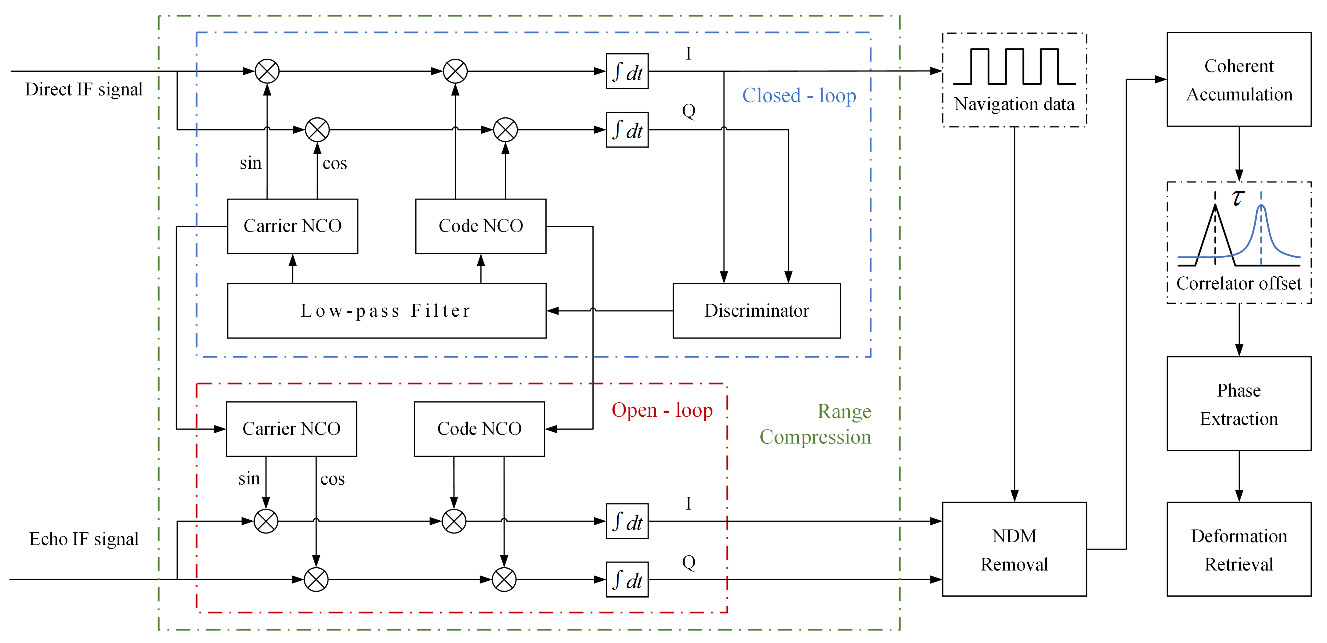
After the RF data are collected and down-converted into IF signals by the RF front end, they are then transferred into the self-defined software receiver for signal processing. The schematic of the proposed software defined receiver and processing procedure is illustrated in Figure 3, where five procedures are involved: range compression, navigation data modulation (NDM) removal, coherent accumulation, carrier phase (hereinafter referred to as phase) extraction and deformation retrieval.

3.2.1. Range Compression

An approach towards the detection of deformation could start with acquiring the range difference, which is available in radar through code-based range compression. In a bistatic radar system, range compression can be regarded as a matched filtering process. During a reflection event, local reference signal S r e f j is generated through closed-loop tracking of direct signal, as illustrated in the blue box in Figure 3. The closed-loop process is mainly for producing a replica of the direct signal (with the same carrier frequency and phase) [25], while the range compression component is carried out synchronously in open-loop mode, as illustrated in the red box in Figure 3. In the open-loop process, echo signal S E c h o j is correlated with the local reference signal in each PRN code period (1 ms).
The outputs of range compression are complex correlation sums that include in-phase (I) and quadrature (Q) components. The range-compressed echo signal can be formulated as follows:
S R C j ( t , n ) = S E c h o j ( t , n ) S r e f j * ( t , n ) = Λ t τ ( n ) exp i φ d j ( n )
where t is the index of PRN code period, n is the index of the sampling time in the PRN code period, Λ is the amplitude of the cross-correlation function of PRN codes, and i 2 = 1 . The illustration of correlator offset is also shown in Figure 3, where the black waveform represents the correlation peak of direct signal, the blue waveform represents the correlation peak of echo signal.

3.2.2. Navigation Data Modulation Removal

When considering the phases of GNSS signals, a topic that must be mentioned is the phase shift caused by the reversal of navigation data. The down-converted GNSS carrier signal after code phase removal is modulated by navigation data, which can be simply regarded as consisting of “+1” and “−1” and manifest itself as cycle slips. In order to extract phase observations from the signal for subsequent deformation retrieval, the effect of the NDM has to be removed.
Different from the traditional phase shift correcting method (i.e., Phase-locked loop mode, (PLL) mode), the NDM of the signal recorded in open-loop mode is removed in post-processing [26]. When the navigation data of the direct signal are extracted as D D i r j , it is available to form a phase reversal solution for the echo signal by D D i r j × S R C j , which can be expressed as
if r e a l ( I p ) < 0 then S N j t , n = S R C j t , n × D D i r j ( t , n ) ( multiplied by 1 )
where I p is the in-phase output of the prompt coherent accumulator, S N j is the signal data after NDM removal.
A comparison example in extracted phase is shown in Figure 4, where the top parts of both sub-figures are derived with NDM and the bottom parts are derived without NDM. It is apparent that after NDM removal, the phases of the GNSS signals are no longer affected by the navigation data and therefore appear to be more continuous and stable.

3.2.3. Coherent Accumulation

With the ground echo signal’s much lower signal intensity compared to that of the direct signal, the noise effect is generally not negligible when estimating centimeter-scale or even millimeter-scale deformations. In order to suppress the noise effect and rise the SNR of echo signals, the coherent accumulation technique is typically applied, and can be modeled as follows:
S j ( p , n ) = p = 1 P 1 S N j ( p × T c o h , n ) , P = T T c o h
where S j p , n represents the result set of data points after coherent accumulation, T is the time span of the collected data, and T c o h is the coherent accumulation interval (CAI).
In coherent accumulation, when the amount of sampling numbers within each CAI (i.e., T c o h ) is referred to as M, the power of the integrated signal component would increase by a factor of M. The amount of SNR improvement after coherent accumulation G c o h can be formulated in decibels as
G c o h = 10 lg M dB
In majority of GNSS receivers, CAI does not usually exceed the duration of navigation data. For instance, the typical CAI of a normal GPS receiver is not longer than 20 ms, otherwise it will cause phase shift issues, which is already addressed by removing NDM. In GNSS bistatic radar, longer integration time is advantageous for SNR improvement. Some researches have also shown coherent accumulation exceeding 1 s [27].
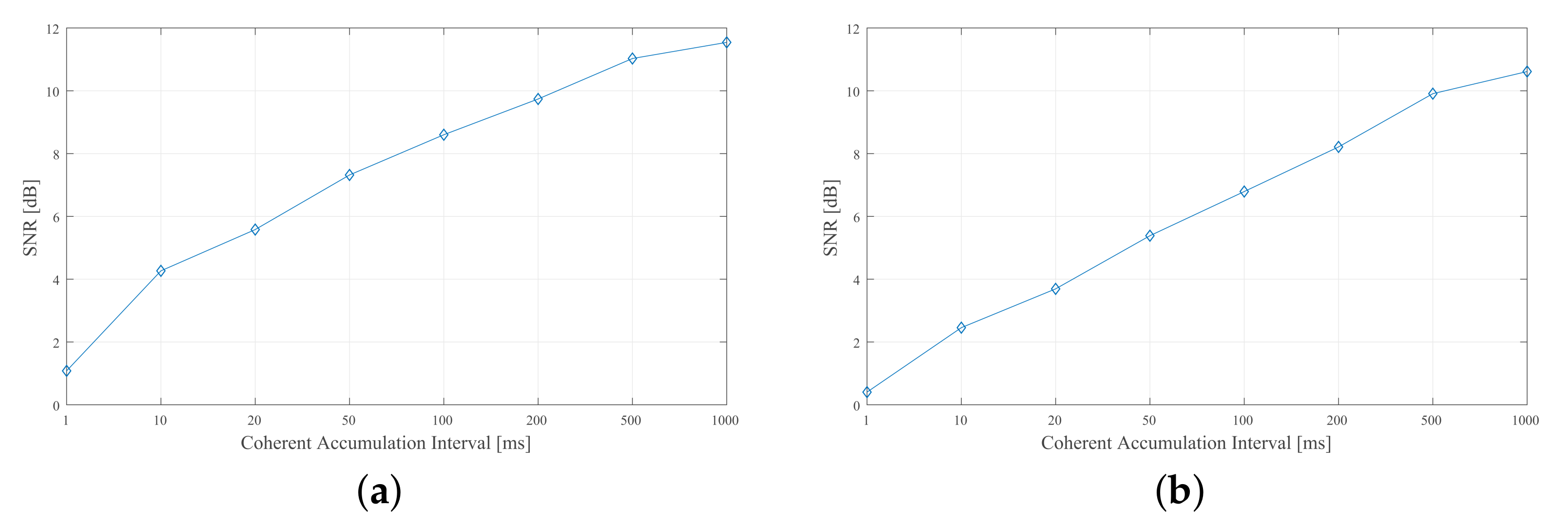
Moreover, the movements of transmitter satellites, such as changes in the orbits of IGSO and MEO satellites, result in a limited time for the signals to cohere. Previous research [28] has revealed that only for 20 min can the signals be considered coherent. Whereas for GEO-satellite-based signals, due to the time-invariant topology, CAI can be significantly increased to several hours or even longer as long as the reflecting surface does not deform. By this means the SNR can be remarkably improved, as shown by the realistic data-processed example given in Figure 5. It can be observed that longer CAI brings higher SNR (i.e., higher coherent gain), which is also supported by Equation (13). Other factors that have influence on the phase include satellite clock offsets, receiver clock offsets, ionospheric delay, and tropospheric delay, etc. Since the employment of dual antennas brings benefits to counteract ionospheric and tropospheric delays and to correct the clock drift, the impact of these factors is neglected in this paper.

3.2.4. Phase Extraction and Deformation Retrieval

The receiver outputs after coherent accumulation are complex correlation sums I and Q, from which both the amplitude A = I 2 + Q 2 and the phase φ = a n g l e ( I + j Q ) can be calculated. The peak phases, extracted from the correlation peaks that locate at τ = R b i s / c , are then selected for deformation retrieval. After obtaining stable peak phase results within complete-cycle range at each position, in accordance with Equation (9), deformation retrieval can be achieved by
d = λ 4 π sin β Δ φ ¯
where Δ φ ¯ denotes the mean difference between stable phase results before and after deformation.

4. Experiment

4.1. Experimental Scenario

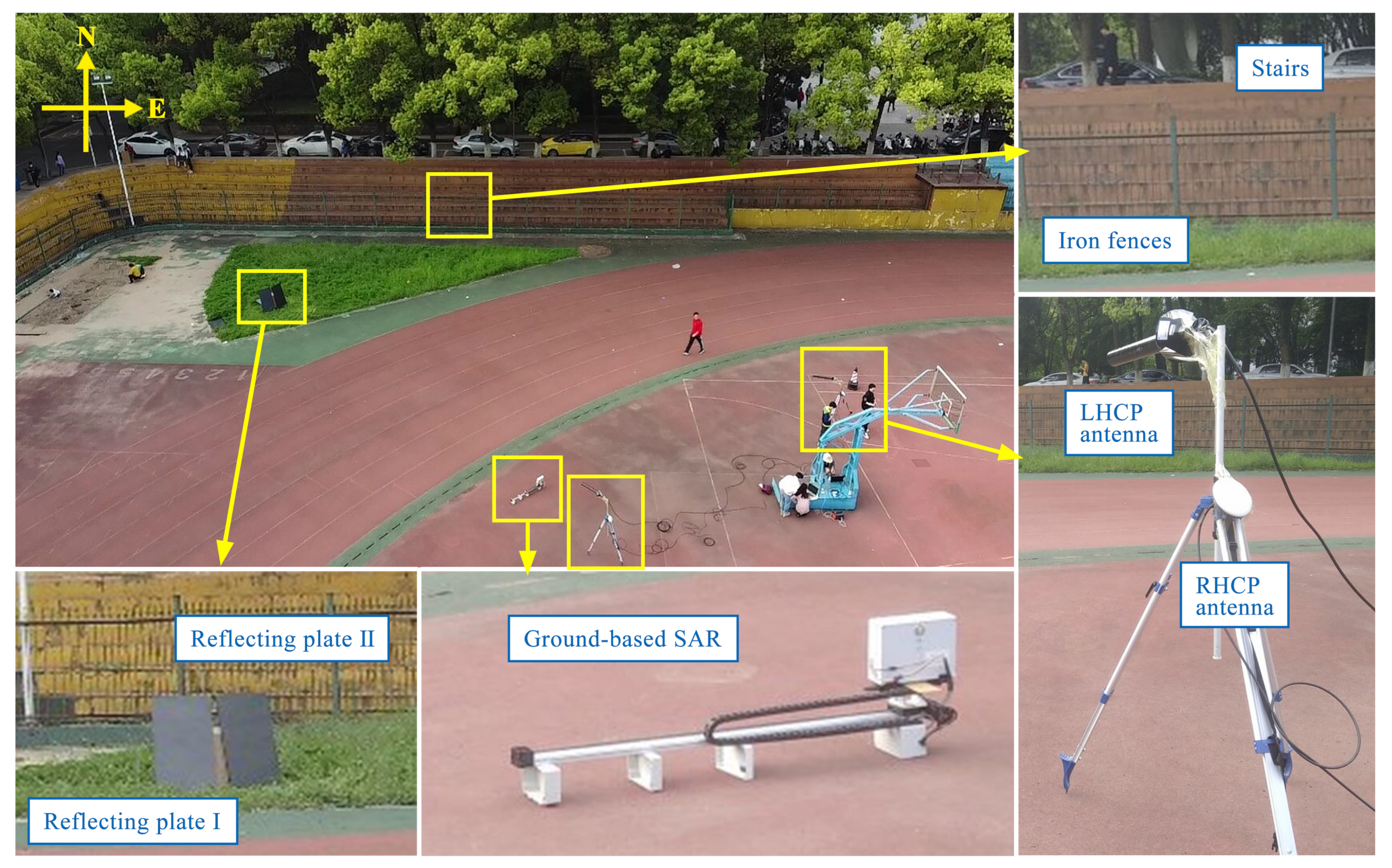
A deformation estimation experiment was designed and conducted at Wuhan University, Wuhan, China (30 53′ N, 114 36′ E), on 15 April 2021. On a playground with a spacious south side, we installed two bistatic radars to create two specular reflection events and tested the performance of two satellites. Beidou-3 GEO satellites C01 and C04 were selected as transmitters based on their azimuths and elevations, therefore ensuring complete reception of GNSS signals without any blockings or multipaths. The experimental system parameters are listed in Table 1, and the experimental setup is illustrated in Figure 6. Two metal reflecting plates with a width of 0.6 m and length of 1.2 m were employed and strictly positioned keeping consistent with the azimuth of the two corresponding satellites to establish specular reflection conditions. Each bistatic radar included a RHCP antenna oriented to the GEO satellite to maximize reception of direct signals and a LHCP antenna oriented to the reflecting plates for echo signals. Antennas were installed on tripods with an approximate height of 1.5 m and connected separately to an eight-channel RF front end for data acquision.
Ranges between the reflecting plates and their corresponding LHCP antennas were approximately 21 m (C01 event) and 25 m (C04 event). The tilt angles of the reflecting plates were precisely 69° (C01 event) and 76° (C04 event), and the azimuths of the LHCP antennas were roughly 137° (C01 event) and 117° (C04 event) from north. Notably, the angle conditions were quite strict, high-precision compass and protractor were employed to calibrate azimuths and tilt angles. The experimental site topology was carefully considered and tested, so that no signal blocking would be detected from the metallic basketball stand and the surrounding buildings and trees. For the testing of the feasibility of ground-based SAR (GB-SAR) in estimating deformation, a GB-SAR device was deployed toward the reflecting plates, ahead of LHCP antenna I.

4.2. Experimental Artificial Deformation

In the experiment, reflecting plates were artificially translated to simulate deformation. The reflecting plates were horizontally translated twice, and data acquisition was conducted three times: (1) before the translation, (2) after the first translation, and (3) after the second translation. At each time, 60 s of raw data were collected, with the reflecting plates remaining stationary. Table 2 lists the artificial deformations in both directions, which are measured by a metric ruler with ranging accuracy of millimeter.

4.3. Data Processing Results

Utilizing the proposed data processing technique illustrated in Figure 3 and expounded upon in Section 3, and the results of each stage are discussed as follows.
(1)
Results of Range Compression
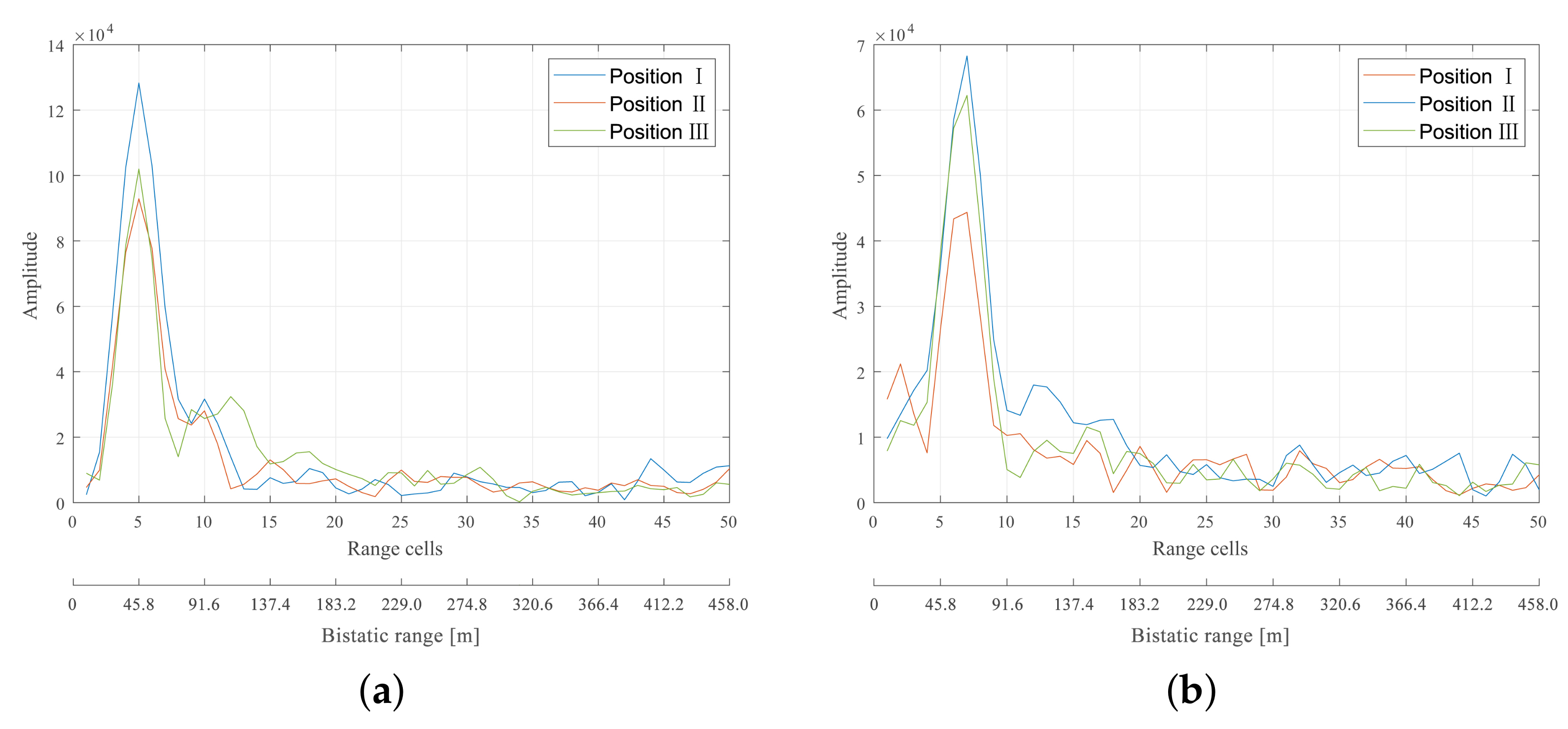
The collected IF data contain multi-channel information, and a cross-correlation process between synchronous signals would be crucial for extracting range information. Figure 7 illustrates the amplitude results of the correlation sum between the local reference signal and the echo signal obtained with Equation (10). Correlation peaks located at the 5th range cell are shown in Figure 7a. In this case GEO C01 was employed with an approximate bistatic range of 36 m within the 5th range cell, indicating that this correlation peak was produced by the echo of reflecting plate I. Similarly, located at the 7th range cell with an approximate bistatic range of 47 m, the correlation peaks shown in Figure 7b could be determined to be produced by the echo of reflecting plate II.
As evidenced by the results, centimeter-level displacement cannot be distinguished by means of range cells alone but requires more precise methods, such as phase-based ones.
(2)
Results of NDM Removal and Coherent Accumulation
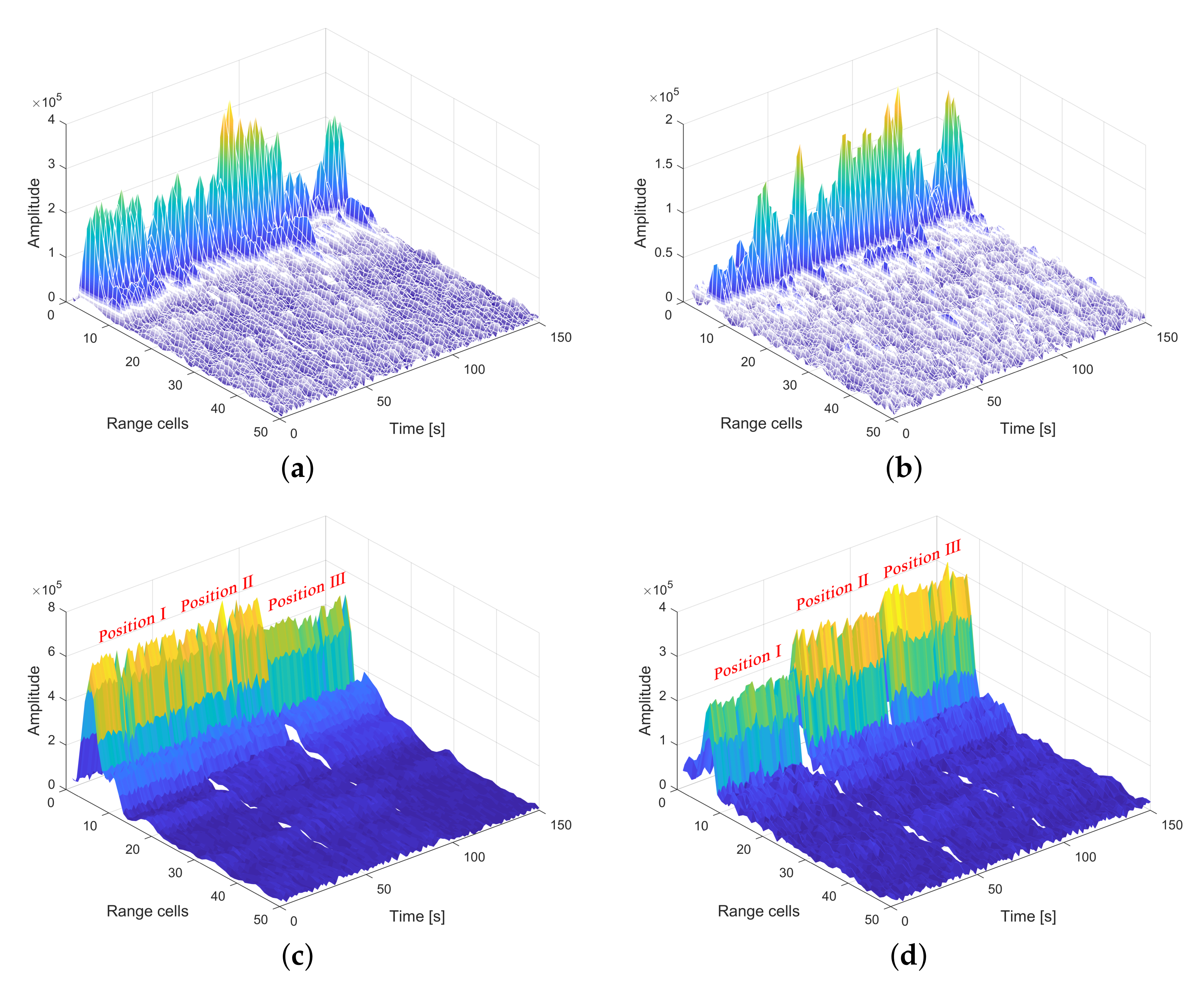
Coherent accumulation is essential for SNR improvement and signal detection. In the experiment, we set the coherent accumulation interval to 200 ms, as it provides a good balance between performance and the computation amount. Figure 8 shows the coherent accumulation results of range-compressed data obtained at three positions separately. As depicted in Figure 8a,b, a discontinuous pattern in amplitude can clearly be observed from the correlation peaks formed with NDM. By contrast, in Figure 8c,d, it is apparent that the echo signal of the corresponding reflecting plate stands out sufficiently above the background noise, showing a great enhancement effect on SNR. Furthermore, the locations of the correlation peaks remain unaltered in range dimension throughout the entire data-processing period.
(3)
Results of Phase Extraction
Phase extraction is accomplished through ϕ = a n g l e ( I + j Q ) . To investigate the distribution of extracted phase information, the values of the extracted phase of GEO C01 and GEO C04 signals are displayed in Figure 9a,b. Figure 9c shows that the extracted phases exhibit relative stability within range cells (3, 7) (i.e., area I) and (8, 15) (i.e., area II) throughout the entire processing period from 0 s to 50 s. On the basis of the bistatic ranges estimated from range compression, area I can be identified as belonging to the reflecting plate I, and area II can be identified as belonging to the rear iron fences and stairs. Similar determination can also be drawn from Figure 9d. In contrast with the stable phase segments that vary slightly, the random phase values extracted from the background are spread within the interval [ 180 , + 180 ], and weak target signals are overwhelmed by the background random noise. After phase extraction, the variations of the phases are recorded for further deformation retrieval.

4.4. Deformation Estimation Results

The deformation estimation results from Equation (14) are shown in Table 3, in two separate directions normal to the reflecting plates I and II (i.e., with the same azimuths as GEO C01 and C04). Notably, the listed ground truth values are already projected to the normal direction. In comparison with the ground truth, the estimated RMSEs for both directions are around 1 cm, indicating that the proposed approach is feasible for estimating deformations with centimeter-level accuracy. There was an unexpected error in the estimation of Deformation II in C04 direction, a likely explanation is that the tilt angle of reflection plate II was affected by some accidental factors after artificial alignment. Further expansion of the deformation estimation accuracy is discussed in Section 5.

5. Discussion

5.1. Result Comparison with Ground-Based SAR

GB-SAR was also investigated as a possible tool for deformation estimation. The parameters of the SAR system are shown in Table 4. Data collection was conducted before and after the artificial deformations displayed in Table 2, the amplitude and the phase spectrum within range were obtained through conjugate multiplication with formula e j θ [29]. In particular, we concentrated on the phase variations since the deformation information is involved.
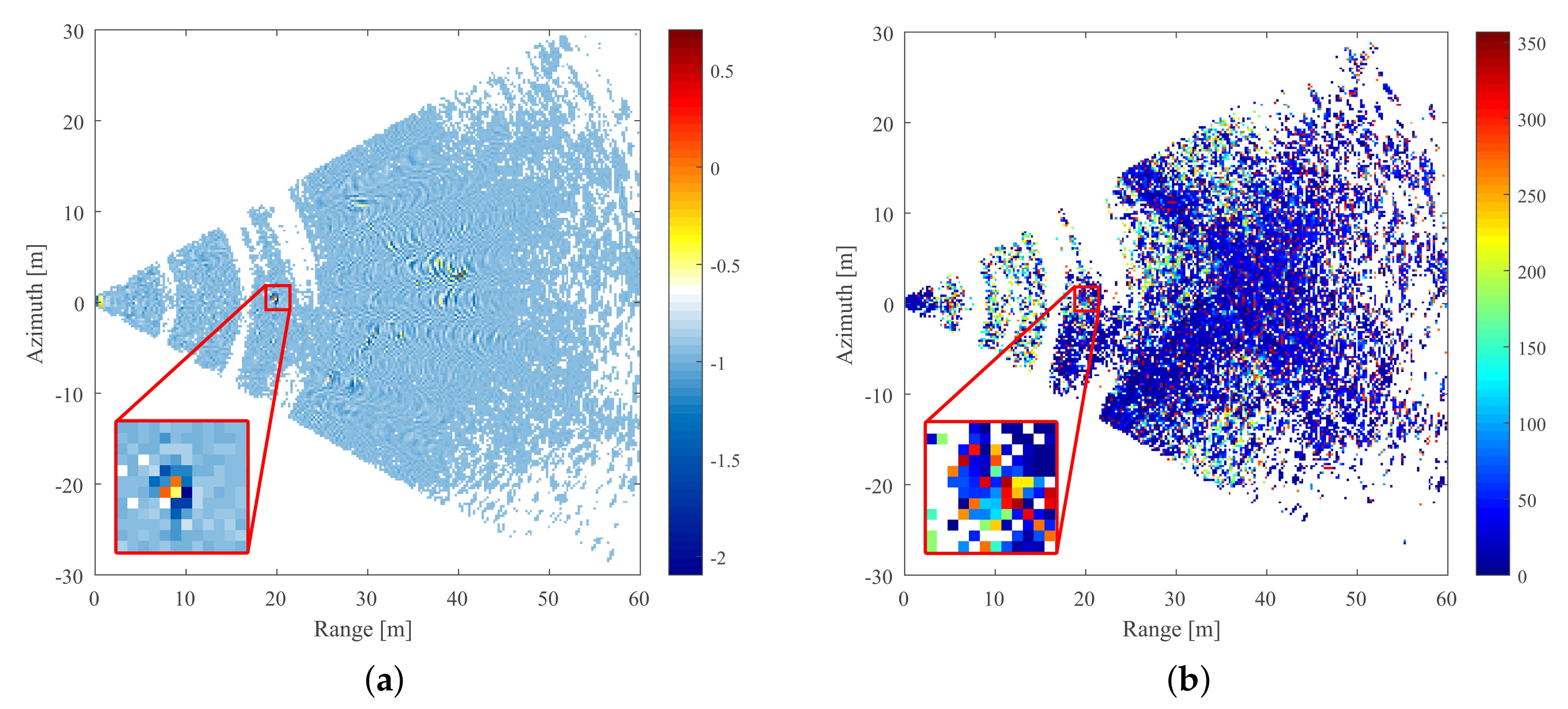
The normalized amplitude spectrum of the initial observation is shown in Figure 10, and the provided geometrical information is consistent with Google maps and the aerial map. Figure 10a depicts the strong reflection from the L-shaped iron fences and rear stairs. Four parallel lines are faintly visible, the first one of which is produced by the iron fences, located at a distance of approximately 30–40 m away from the observation point. The marked area in Figure 10b shows the strong reflection from the target reflecting plates, which is at the range distance of 20 m and the azimuth distance of 0 m from the observation point. The target shape can also be distinguished as two rectangles overlapping with an obtuse included angle, and each rectangle covers an area of 2 × 2 pixels (pixel size equals range resolution by azimuth resolution of 0.25 m × 0.25 m). This result is due to the fact that the reflecting plates are inclined to the ground and not completely extended in range. Further details are given in the zoomed-in view.
The phase calculation results are presented in radians in Figure 11a, in which there is a distinct mutation, indicating that the phase difference of the reflecting plates stands out of the background. As can be seen, the phase difference of the target central area is positive (yellow and orange), while it is negative (deep blue) for the adjacent edges. Moreover, the iron fences and rear stairs manifest themselves as interferometric fringes.
The phase variation spectrum is depicted in Figure 11b in degrees. The target area is submerged in background random noises, while the positions of iron fences and rear stairs are marked by a deep-blue L-shaped area with a universal phase variation of less than 50 degrees. Similar features could also be observed with the GNSS-R-based method, as shown in Figure 9.
Yet despite detecting some deformation in the target area, the GB-SAR estimation result has an incorrect order of magnitude based on the calculation. For this two-way estimating method and to satisfy Nyquist sampling theorem, the estimable deformation quantity is required to be less than one-quarter-wavelength [30], while the Deformation I is 2 cm (>1.4 cm), causing severe deviations.
Benefit from the high positioning accuracy, GB-SAR has been extensively accepted as a typical deformation estimating tool. Compared to the proposed GNSS-R system, the GB-SAR has significantly improved range resolution (i.e., 0.25 m vs. the 30 m from proposed system). Meanwhile, the shorter wavelength (i.e., 5.6 cm vs. the 24 cm from proposed system) allows GB-SAR to achieve up to millimeter-level accuracy while estimating deformations. Nevertheless, its shortcomings are also obvious. GB-SAR system requires transmitter and ground track to form synthetic aperture, leading to a relatively high system cost and complexity. By contrast, the proposed GNSS-R deformation estimating system is distinguished by the advantage of low-cost and simplicity.
In our experiment, GB-SAR appears to be unsuitable for estimating deformations greater than several centimeters, which fall exactly within the best performing range of the proposed bistatic radar system. Inspired, the proposed bistatic radar system may be regarded as a supplement to GB-SAR in extending deformation estimation ranges.

5.2. Effect of SNR on Phase Stability and Deformation Retrieval

PSs generally exhibit a stable phase under high SNR in SAR reflection, and thus phase stability is considered a noticeable criterion. A number of physical structures, such as the reflecting plates and iron fences, were considered PSs during the experiment.
Figure 12a,b display the phase results extracted from the GNSS signals in three positions, from which the phase variations during the two deformations can also be determined. The results indicate that the extracted phases of echo signals from a stationary object perturb around their mean value, and phase stability varies with SNR. As marked by the red dashed boxes in Figure 12a, a considerable amount of disturbance occurs during certain low-SNR processing periods and should therefore be excluded from the deformation results calculation. Accordingly, the most stable time periods (superior), the time periods with the most fluctuations (inferior), and the average-level periods (mediocre) for each collected dataset were selected (marked by black dashed boxes in both subfigures) for further analysis. In this case the selected time span is determined to be 10 s.
The phase stability and deformation estimation stability comparison results between processing periods with different SNR values are shown in Table 5. In estimating deformation, we assume the last periods to be ideally stable. The results indicate that the phases and the estimated deformations are relatively unstable when obtained from the low-SNR periods, whereas a higher degree of stability is observed for the extracted phases and estimated deformations from the high-SNR periods. Additionally, such a quantitative discovery is in accordance with the conditions outlined in the dashed red box in Figure 12a.
In future work on the monitoring of practical deformations, this discovery could provide guidance for site selection. Similar to PSs in SAR images, physical structures with relatively stable echoes in the deformed area, such as flat slopes, have the potential to be used as natural reflecting plates for GNSS-R-based deformation monitoring applications.

5.3. Study on Estimation Range Extension

According to the proposed reflectometry technique, deformation estimations can be accomplished by either code-based or carrier-phase-based approaches. With code-based (i.e., range compression) approaches, the estimation accuracy is solely determined by the limited bandwidth of Beidou B3I signals, which is inadequate for the majority of practical applications [2], whereas for phase-based methods, which are typically restricted by the wrap problem, the phases are only measured modulo 2 π , causing interger ambiguity issues (similar to SAR).
Technically, if deformation does not occur too rapidly (within one configurated CAI), then its variation trend is available to be identified in terms of phase temporal continuity. For simplicity, the term “overrange deformation” is used hereinafter to refer to certain types of deformation with an extracted phase exceeding one complete cycle. In order to provide a solution to the estimation of overrange deformations, a novel phase-based technique was introduced and preliminary validated through an additional experiment.
Given that the extracted phase is greater than 2 π , the overrange deformation quantity can be divided into fractional and integer parts. The step-by-step estimation process of the novel method is as follows:
(1)
Continuously record the GNSS direct and echo signals.
(2)
Perform phase extractions over the entire processing period, detect the deviants in phase (assuming that only one deviant exists within one certain time segment), and take the time segment in which the deviant arises into further analysis.
(3)
Retrieve the fractional part of deformation quantity d f r a c with the sums of phase variations at the beginning and the ending segments Δ φ b e g i n + Δ φ e n d .
(4)
Retrieve the integer part of deformation quantity d i n t e with the amount of complete cycles, which can be derived by subtracting one from the number of phase reversals N. Consequently, the overrange deformation quantity d o v e r could be expressed as:
d o v e r = d f r a c + d i n t e = λ 4 π sin β Δ φ b e g i n + Δ φ e n d + N 1 360
where d f r a c denotes the fractional part of deformation quantity and d i n t e denotes the integer part of deformation quantity.
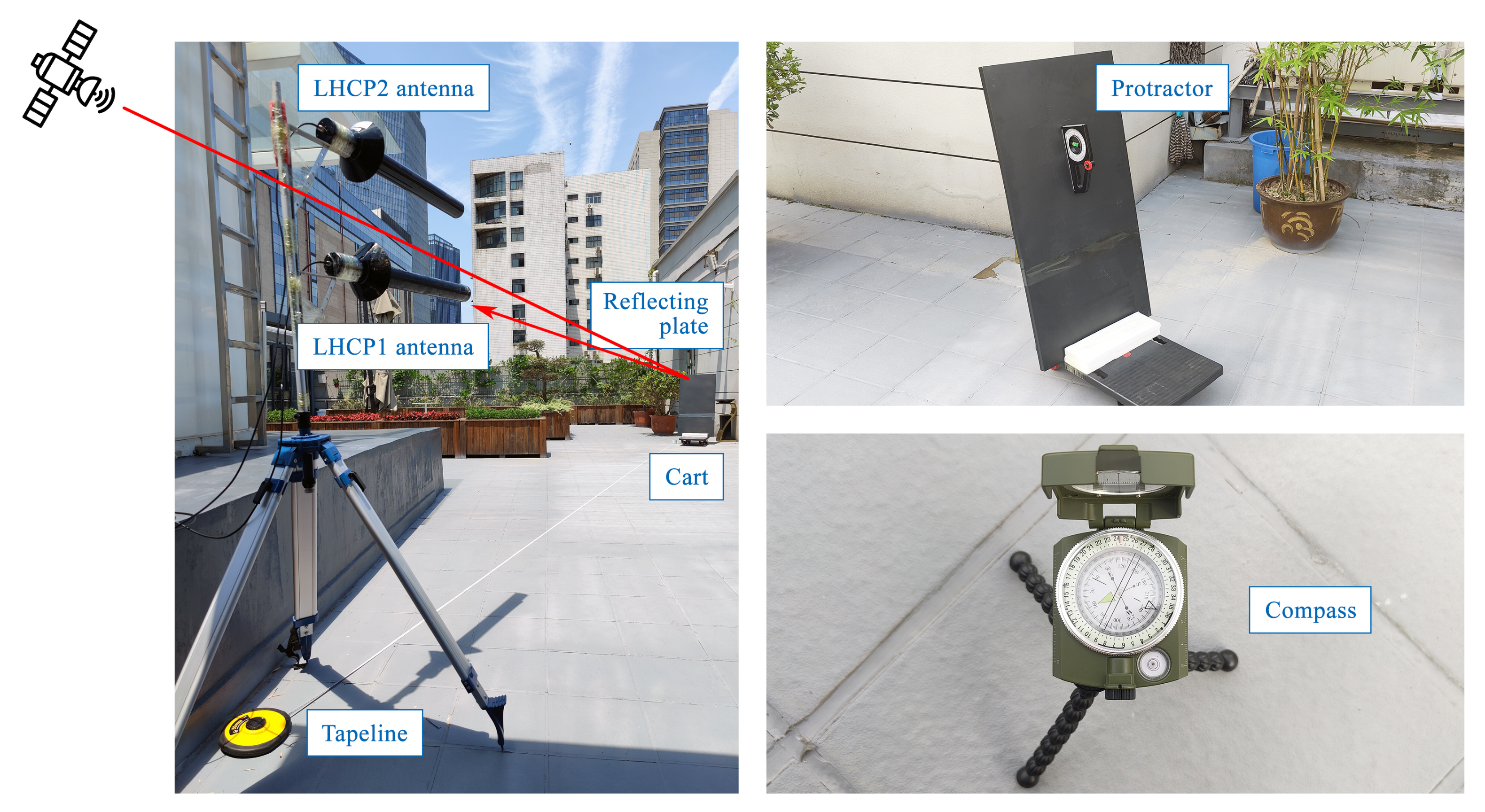
To certify the theory, an additional overrange deformation experiment was designed and conducted at the rooftop of a building in Wuhan University, Wuhan, China (30 53′ N, 114 36′ E), on 23 June 2021. The experimental scenario is shown in Figure 13, GEO C04 was employed as the transmitter, as well as a RHCP antenna and two LHCP antennas for data acquisition. With two LHCP antennas, a larger amounts of data could be available for analysis, which improved the credibility of the experiment. To ensure the temporal continuity of phase components, one reflection plate was mounted onto a cart and slowly translated towards the LHCP antennas.
Two datasets with different artificial deformation histories were separately collected for 60 s. While collecting dataset 1, the reflecting plate was kept stationary for three periods (0–12 s in Position I, 18–30 s in Position II, 35–60 s in Position III) and translated twice (12–18 s for Deformation I, 30–35 s for Deformation II). While collecting dataset 2, the reflecting plate was kept stationary for three periods (0–18 s, 22–35 s, 47–60 s) and translated twice (18–22 s, 35–47 s).
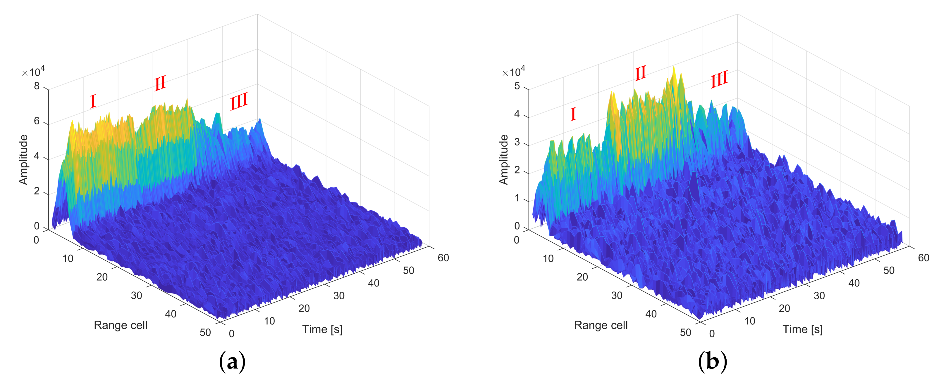
Figure 14 and Figure 15 show the correlation peak results for the two datasets. With the bistatic range ranging from 26 m to 22 m approximately, the locations of correlation peaks remain unaltered within the 4th range cell over the entire data processing periods. In accordance with Positions I, II, and III, three periods with relatively stable amplitudes are marked using Roman numerals. The variations in amplitude among the positions are likely caused by the position variance of the specular reflection point, resulting in the echo signal being received by LHCP antennas from the angles of their lower lobe gain.
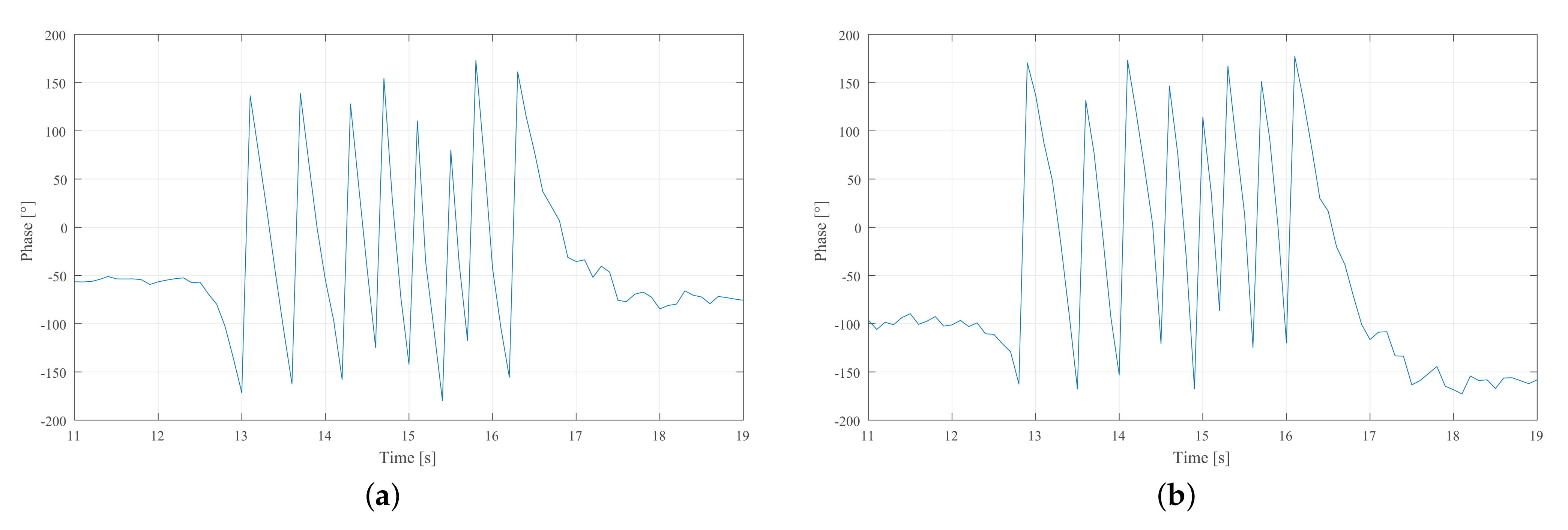
The continuous extracted phases are shown in Figure 16, it can be observed that there are three stable phase segments representing three static positions of the target reflecting plate. The two segments of phase variations depicted by the green dashed boxes in Figure 16a are produced by Deformations I and II, respectively.
The first phase variation segments from both LHCP1 and LHCP2 in dataset 1 are quantitatively analyzed as examples. As shown in Figure 17, the LHCP1 phase component experienced eight phase reversals (i.e., seven complete cycles) and a residual phase variation of 374 , sum to the deformation estimation result of 99.0041 cm. Similarly, the LHCP2 phase component experienced eight phase reversals and residual phase variation of 415 , sum to deformation estimation result of 100.4068 cm. The deformation estimation results utilizing such proposed method are displayed in Table 6.
According to the results, the proposed method is available of estimating overrange deformations with an accuracy better than 3 cm. The additional experiment produces a lower estimation accuracy than the preceding playground experiment. The reason for this could probably be the instability of echo phases from the jolting during translations and the errors in the ground-truth measurements. In addition, it should be noted that this method is not suitable for deformations occurring within a short time period, which leads to unpredictable phase reversals.
Due to the weak intensity of echo GNSS signal (i.e., intensity loss during GNSS signal reflection), the proposed bistatic radar system has certain requirements regarding the minimum energy of the echo signal, bringing limitations. Permanent scatters with enough RCS are required to generate stronger echo signal, so as to be accepted for processing. In addition, GEO satellite, reflectometry, and the target are required to be under appropriate geographical conditions and topologies allowing the bistatic radar to be constructed. Typically, the GEO satellites lie in the south of the observer in vast majority areas of China. As a consequence of the back-scattering model, receiver deployment in the south is also required to receive the echo signal from the northern reflector. In the future, further investigation of estimation error analysis will be worked.

6. Conclusions

This paper presents a GEO-based GNSS-R system and a phase-based deformation estimation approach, both were tested through ground-based experiments. On the basis of the proposed bistatic radar system, a reflection path model was investigated to establish the connection between deformation quantity and phase variation. The open-loop tracking algorithm, utilizing amplitude and phase observations that were obtained from I/Q outputs, provided accessibility to the phase-based deformation retrieval. The effects of NDM and coherent accumulation on phase extraction results were also verified. It appears that the removal of NDM is crucial for providing stable, continuous phase observations, and coherent accumulation is essential for SNR improvement of target echoes, as well as the subsequent signal identification.
A ground-based experiment was designed and conducted to test the performance of the proposed system and approach. Specular reflection conditions were created for two bistatic radar systems by using two reflecting plates, and the deformation estimating performance of two Beidou-3 GEO satellites were investigated. Utilizing the proposed approach, the results indicate that the deformations of the reflecting plates can be retrieved with a RMSE of about 1 cm compared with the metric ruler measurements. The same deformation history was also estimated by GB-SAR, whose results showed that deformations greater than several centimeters cannot be reliably estimated by GB-SAR due to its limited wavelength. Accordingly, the proposed bistatic radar system may be regarded as complementary to GB-SAR in terms of extending deformation estimation ranges.
By analysis of the effect of SNR on phase stability and deformation retrieval, generally the stability of extracted phase and estimated deformation rises with signal SNR. Such a discovery could provide guidance for site selection in GNSS-R deformation monitoring applications, since the objects with relatively stable echoes possess the potential to serve as natural reflecting plates.
The feasibility of overrange deformation estimation was also preliminarily tested by an additional experiment. During data acquisition, a reflecting plate was alternately kept stationary and translated to simulate continuous overrange deformations. The results reveal that overrange deformations can be estimated with accuracy better than 3 cm, if they do not emerge too fast.
Future investigations will mainly focus on deformation estimations based on GNSS interferometric reflectometry (GNSS-IR). Given that the deformations in current testing experiments were simulated via the artificial translation of reflecting plates, experiments on natural deformation monitoring are also desired. Moreover, further research on error analysis will be worked.

Author Contributions

Conceptualization, Y.C.; Formal analysis, Y.C.; Methodology, Y.C., S.Y. and J.G.; Supervision, S.Y. and J.G.; Validation, S.Y.; Writing-original draft, Y.C.; Writing—review & editing, S.Y. All authors have read and agreed to the published version of the manuscript.

Funding

This paper is supported by The National Natural Science Foundartion of China under grant NSFC42071406.

Institutional Review Board Statement

Not applicable.

Informed Consent Statement

Not applicable.

Data Availability Statement

Not applicable.

Acknowledgments

Special thanks are given to the anonymous reviewers who greatly helped to improve the quality of the manuscript.

Conflicts of Interest

The authors declare no conflict of interest.

References

  1. Huang, R.; Fan, X. The landslide story. Nat. Geosci. 2013, 6, 325–326. [Google Scholar] [CrossRef]
  2. Jia, H.; Zhang, H.; Liu, L.; Liu, G. Landslide Deformation Monitoring by Adaptive Distributed Scatterer Interferometric Synthetic Aperture Radar. Remote Sens. 2019, 11, 2273. [Google Scholar] [CrossRef] [Green Version]
  3. Luo, T.; Li, F.; Pan, B.; Zhou, W.; Chen, H.; Shen, G.; Hao, W. Deformation Monitoring of Slopes With a Shipborne InSAR System: A Case Study of the Lancang River Gorge. IEEE Access 2021, 9, 5749–5759. [Google Scholar] [CrossRef]
  4. Yang, S.S.; Potirakis, S.M.; Sasmal, S.; Hayakawa, M. Natural Time Analysis of Global Navigation Satellite System Surface Deformation: The Case of the 2016 Kumamoto Earthquakes. Entropy 2020, 22, 674. [Google Scholar] [CrossRef]
  5. Rezvani, M.H.; Watson, C.S.; King, M.A. Estimating Vertical Land Motion and Residual Altimeter Systematic Errors Using a Kalman-Based Approach. J. Geophys. Res. Ocean. 2021, 126, e2020JC017106. [Google Scholar] [CrossRef]
  6. Yang, Z.F.; Li, Z.W.; Zhu, J.J.; Hu, J.; Wang, Y.J.; Chen, G.L. InSAR-Based Model Parameter Estimation of Probability Integral Method and Its Application for Predicting Mining-Induced Horizontal and Vertical Displacements. IEEE Trans. Geosci. Remote Sens. 2016, 54, 4818–4832. [Google Scholar] [CrossRef]
  7. Parizzi, A.; Brcic, R.; De Zan, F. InSAR Performance for Large-Scale Deformation Measurement. IEEE Trans. Geosci. Remote Sens. 2020. [Google Scholar] [CrossRef]
  8. Hong, S.; Liu, M. Postseismic Deformation and Afterslip Evolution of the 2015 Gorkha Earthquake Constrained by InSAR and GPS Observations. J. Geophys. Res. Solid Earth 2021, 126, e2020JB020230. [Google Scholar] [CrossRef]
  9. Qiu, Z.; Jiao, M.; Jiang, T.; Zhou, L. Dam Structure Deformation Monitoring by GB-InSAR Approach. IEEE Access 2020, 8, 123287–123296. [Google Scholar] [CrossRef]
  10. Xiao, R.; Shi, H.; He, X.; Li, Z.; Jia, D.; Yang, Z. Deformation Monitoring of Reservoir Dams Using GNSS: An Application to South-to-North Water Diversion Project, China. IEEE Access 2019, 7, 54981–54992. [Google Scholar] [CrossRef]
  11. Arnoso, J.; Riccardi, U.; Benavent, M.; Tammaro, U.; Montesinos, F.G.; Blanco-Montenegro, I.; Vélez, E. Strain Pattern and Kinematics of the Canary Islands from GNSS Time Series Analysis. Remote Sens. 2020, 12, 3297. [Google Scholar] [CrossRef]
  12. Zou, X.; Li, Z.; Li, Y.; Wang, Y.; Tang, W.; Deng, C.; Cui, J.; Fu, R. A Novel Method to Mitigate the Multipath Error for BDS-2 Dam Deformation Monitoring. Remote Sens. 2021, 13, 1787. [Google Scholar] [CrossRef]
  13. Yang, Y.; Zheng, Y.; Yu, W.; Chen, W.; Weng, D. Deformation monitoring using GNSS-R technology. Adv. Space Res. 2019, 63, 3303–3314. [Google Scholar] [CrossRef]
  14. Rodriguez-Alvarez, N.; Bosch-Lluis, X.; Camps, A.; Vall-llossera, M.; Valencia, E.; Marchan-Hernandez, J.F.; Ramos-Perez, I. Soil Moisture Retrieval Using GNSS-R Techniques: Experimental Results Over a Bare Soil Field. IEEE Trans. Geosci. Remote Sens. 2009, 47, 3616–3624. [Google Scholar] [CrossRef]
  15. Clarizia, M.P.; Pierdicca, N.; Costantini, F.; Floury, N. Analysis of CYGNSS Data for Soil Moisture Retrieval. IEEE J. Sel. Top. Appl. Earth Obs. Remote Sens. 2019, 12, 2227–2235. [Google Scholar] [CrossRef]
  16. Clarizia, M.P.; Ruf, C.S.; Jales, P.; Gommenginger, C. Spaceborne GNSS-R Minimum Variance Wind Speed Estimator. IEEE Trans. Geosci. Remote Sens. 2014, 52, 6829–6843. [Google Scholar] [CrossRef]
  17. Foti, G.; Gommenginger, C.; Jales, P.; Unwin, M.; Shaw, A.; Robertson, C.; Roselló, J. Spaceborne GNSS reflectometry for ocean winds: First results from the UK TechDemoSat-1 mission. Geophys. Res. Lett. 2015, 42, 5435–5441. [Google Scholar] [CrossRef] [Green Version]
  18. Jacobson, M.D. Dielectric-Covered Ground Reflectors in GPS Multipath Reception—Theory and Measurement. IEEE Geosci. Remote Sens. Lett. 2008, 5, 396–399. [Google Scholar] [CrossRef]
  19. Vey, S.; Güntner, A.; Wickert, J.; Blume, T.; Thoss, H.; Ramatschi, M. Monitoring Snow Depth by GNSS Reflectometry in Built-up Areas: A Case Study for Wettzell, Germany. IEEE J. Sel. Top. Appl. Earth Obs. Remote Sens. 2016, 9, 4809–4816. [Google Scholar] [CrossRef] [Green Version]
  20. Tabibi, S.; Geremia-Nievinski, F.; van Dam, T. Statistical Comparison and Combination of GPS, GLONASS, and Multi-GNSS Multipath Reflectometry Applied to Snow Depth Retrieval. IEEE Trans. Geosci. Remote Sens. 2017, 55, 3773–3785. [Google Scholar] [CrossRef]
  21. Liu, F.; Fan, X.; Zhang, T.; Liu, Q. GNSS-Based SAR Interferometry for 3-D Deformation Retrieval: Algorithms and Feasibility Study. IEEE Trans. Geosci. Remote Sens. 2018. [Google Scholar] [CrossRef]
  22. Li, W.; Fabra, F.; Yang, D.; Rius, A.; Martín-Neira, M.; Yin, C.; Wang, Q.; Cao, Y. Initial Results of Typhoon Wind Speed Observation Using Coastal GNSS-R of BeiDou GEO Satellite. IEEE J. Sel. Top. Appl. Earth Obs. Remote Sens. 2016, 9, 4720–4729. [Google Scholar] [CrossRef]
  23. Ban, W.; Yu, K.; Zhang, X. GEO-Satellite-Based Reflectometry for Soil Moisture Estimation: Signal Modeling and Algorithm Development. IEEE Trans. Geosci. Remote Sens. 2018, 56, 1829–1838. [Google Scholar] [CrossRef]
  24. Wu, J.; Chen, Y.; Gao, F.; Guo, P.; Wang, X.; Niu, X.; Wu, M.; Fu, N. Sea Surface Height Estimation by Ground-Based BDS GEO Satellite Reflectometry. IEEE J. Sel. Top. Appl. Earth Obs. Remote Sens. 2020, 13, 5550–5559. [Google Scholar] [CrossRef]
  25. Nogues-Correig, O.; Cardellach Gali, E.; Sanz Campderros, J.; Rius, A. A GPS-Reflections Receiver That Computes Doppler/Delay Maps in Real Time. IEEE Trans. Geosci. Remote Sens. 2007, 45, 156–174. [Google Scholar] [CrossRef]
  26. Chiu, T.C.; Liou, Y.A.; Yeh, W.H.; Huang, C.Y. NCURO Data-Retrieval Algorithm in FORMOSAT-3 GPS Radio-Occultation Mission. IEEE Trans. Geosci. Remote Sens. 2008, 46, 3395–3405. [Google Scholar] [CrossRef]
  27. Pany, T.; Riedl, B.; Winkel, J.; Woerz, T.; Schweikert, R.; Niedermeier, H.; Lagrasta, S.; Lopez-Risueno, G.; Jiménez-Baños, D. Coherent integration time: The longer, the better. Inside GNSS 2009, 4, 52–61. [Google Scholar]
  28. Liu, W.; Beckheinrich, J.; Semmling, M.; Ramatschi, M.; Vey, S.; Wickert, J.; Hobiger, T.; Haas, R. Coastal Sea-Level Measurements Based on GNSS-R Phase Altimetry: A Case Study at the Onsala Space Observatory, Sweden. IEEE Trans. Geosci. Remote Sens. 2017, 55, 5625–5636. [Google Scholar] [CrossRef]
  29. Feng, W.; Nico, G.; Sato, M. GB-SAR Interferometry Based on Dimension-Reduced Compressive Sensing and Multiple Measurement Vectors Model. IEEE Geosci. Remote Sens. Lett. 2019, 16, 70–74. [Google Scholar] [CrossRef]
  30. Zebker, H.A.; Lu, Y. Phase unwrapping algorithms for radar interferometry: Residue-cut, least-squares, and synthesis algorithms. J. Opt. Soc. Am. A 1998, 15, 586. [Google Scholar] [CrossRef]
Figure 1. (a) Geometry of bistatic GNSS radar system based on geostationary earth orbit (GEO) satellites. (b) Reflection path model.
Remotesensing 13 03285 g001
Figure 2. Data acquisition devices: antennas, hardware front end and computer served as software receiver.
Remotesensing 13 03285 g002
Figure 3. Schematic of software defined receiver and processing procedure.
Remotesensing 13 03285 g003
Figure 4. Comparison example in extracted phase (a) GEO C01 observation (top) with NDM and (bottom) without NDM; (b) GEO C04 observation (top) with NDM and (bottom) without NDM.
Remotesensing 13 03285 g004
Figure 5. SNR results with respect to coherent accumulation interval. Calculated by the experimental data collected from Beidou-3 GEO satellites, on 15 April 2021 (a) C01 observation (b) C04 observation.
Remotesensing 13 03285 g005
Figure 6. Experimental scenario photographed by drone.
Remotesensing 13 03285 g006
Figure 7. Correlation peaks of three positions after range compression and coherent accumulation. (a) C01 observation (b) C04 observation.
Remotesensing 13 03285 g007
Figure 8. Coherent accumulation results of three positions. (a) C01 observation with NDM (b) C04 observation with NDM (c) C01 observation without NDM (d) C04 observation without NDM.
Remotesensing 13 03285 g008
Figure 9. Extracted phase results (a) 3D view of C01 observation (b) 3D view of C04 observation (c) Side-view of C01 observation (d) Side-view of C04 observation.
Remotesensing 13 03285 g009
Figure 10. Normalized amplitude spectrum. Observations on 15th April. (a) In 17:47, before Deformation I (b) In 17:58, after Deformation I.
Remotesensing 13 03285 g010
Figure 11. Phase difference spectrum. (a) In radians (b) In degrees.
Remotesensing 13 03285 g011
Figure 12. SNR and extracted phase results of three positions. (a) C01 (b) C04.
Remotesensing 13 03285 g012
Figure 13. Experimental scenario of the additional overrange deformation experiment.
Remotesensing 13 03285 g013
Figure 14. Correlation peak results for dataset 1 (a) LHCP1 (b) LHCP2.
Remotesensing 13 03285 g014
Figure 15. Correlation peak results for dataset 2 (a) LHCP1 (b) LHCP2.
Remotesensing 13 03285 g015
Figure 16. Extracted phase results (a) for dataset 1 (b) for dataset 2.
Remotesensing 13 03285 g016
Figure 17. Zoomed extraced phase results for Deformation I in datatset 1 (a) LHCP1 observation (b) LHCP2 observation.
Remotesensing 13 03285 g017
Table 1. Experimental system parameters.
C01/Reflecting Plate IC04/Reflecting Plate II
Sampling frequency32.738 MHz
Signal Bandwidth10.23 MHz
Central frequency0.1271125 MHz
Satellite azimuth137 117
Satellite elevation43 28
Tilt angle69 76
bistatic range36 m47 m
Table 2. The artificial deformation quantities.
Deformation IDeformation II
Reflecting plate I (C01 event)2 cm4 cm
Reflecting plate II (C04 event)2 cm5 cm
Table 3. Deformation estimation results for both datasets.
SatelliteEventEstimation (cm)Ground Truth (cm)RMSE (cm)
C01Deformation I0.511.880.85
Deformation II4.273.75
C04Deformation I0.891.931.04
Deformation II10.344.83
Table 4. GB-SAR system parameters.
ParametersValue
Central frequency5.6 GHz (Waveband C)
Wavelength5.6 cm
Signal bandwidth600 MHz
Range resolution0.25 m
Azimuth resolution0.25 m
Table 5. Analysis of SNR on phase stability and deformation estimation stability.
SatellitePeriod ClassSNR (dB)Phase RMSE ( )Deformation RMSE (cm)
3C01Superior8.612.770.09
Mediocre8.446.560.22
Inferior8.358.290.28
3C04Superior8.162.490.08
Mediocre8.147.300.25
Inferior7.9511.380.39
Table 6. Deformation estimation results for both datasets.
Event Estimatio n LHCP 1 ( cm ) Estimatio n LHCP 2 ( cm ) Ground Truth (cm)RMSE (cm)
2Dataset 1Deformation I99.00100.4197.032.77
Deformation II96.7894.9097.031.52
2Dataset 2Deformation I9.659.379.700.24
Deformation II186.99187.03184.362.65
Publisher’s Note: MDPI stays neutral with regard to jurisdictional claims in published maps and institutional affiliations.