Comparison of Multi-Year Reanalysis, Models, and Satellite Remote Sensing Products for Agricultural Drought Monitoring over South Asian Countries
Abstract
:1. Introduction
2. Materials and Methods
2.1. Study Area
2.2. Data
2.2.1. Precipitation
- (I).
- The Climate Hazard Group Infrared Precipitation with Stations (CHIRPS) dataset provides global data (50°N–50°S) at monthly, five-day, and daily intervals with a 0.05° spatial resolution. CHIRPS data comprise the combination of satellite estimation and in-situ/station observation data based upon cold cloud duration (CCD) data. Primarily, CHIRPS data have been produced for agricultural drought monitoring [33]. Monthly product version 2.0 was downloaded from ftp://ftp.chg.ucsb.edu/pub/org/chg/products/CHIRPS-2.0/ (accessed on 9 February 2021) for the period 1982 to 2019. CHIRPS precipitation data are frequently used for hydrology and drought-related studies [12,28,34].
- (II).
- The Global Precipitation Climatology Center (GPCC) reanalysis dataset, version 7, at a monthly basis with a 0.5° spatial resolution, has been accessed via ftp://ftp.dwd.de/pub/data/gpcc/html/fulldata_v7_doi_download.html (accessed on 12 February 2021) from 1982 to 2019. Additionally, this product is gauge-gridded based on 75,000 global rain gauge stations and has been used for drought monitoring [12].
2.2.2. Soil Moisture
- (I).
- The second Modern-Era Retrospective Analysis for Research and Application (MERRA-2) soil moisture (reanalysis) product is a replacement of the original MERRA reanalysis product of the US National Aeronautics and Space Administration [35]. The monthly soil moisture product, having a 0.625° by 0.5° root zone, has been downloaded from https://gmao.gsfc.nasa.gov/reanalysis/MERRA-2/data_access/ (accessed on 12 February 2021) for the duration of 1982 to 2019. Due to better data forcing (observation-corrected precipitation) and an upgraded assimilation system (upgraded canopy interception), MERRA-2 provides enhanced soil moisture (SM) evaluation when compared to MERRA [36].
- (II).
- The ERA5 reanalysis dataset is a replacement of ERA-Interim (reanalysis) dataset and is based on a four-dimensional integration which enhances essential dynamics and model physics [37]. The European Center for Medium Range Weather Forecasts offers a temporal series of various variables from 1981 to the present. The monthly ERA5 average reanalysis soil moisture (SM) product is available with a regular grid size of 0.1° × 0.1° [38]. These data have been used for the period of 1982–2019 as per the https://www.ecmwf.int/en/forecasts/datasets website (accessed on 6 march 2021).
- (III).
- The Climate Prediction Center (CPC) provides several SM products. Soil moisture version 2 data, at a monthly basis with a 0.5° spatial resolution, are used in the existing study for the period from 1982 to 2019. This dataset was acquired from the laboratory database of the National Oceanic and Atmospheric Administration website http://www.esrl.noaa.gov/psd/data/gridded/data.cpcsoil.html (accessed on 16 February 2021). This dataset is considered in present study because it includes in situ precipitation as an input and thus is considered to provide data that would be very close to the real soil moisture data [39].
- (IV).
- The Global Land Assimilation System (GLDAS), with the soil moisture version 2 dataset, was used at a monthly basis with a 1° spatial resolution as downloaded from http://disc.sci.gsfc.nasa.gov/services/grads-gds/glades (accessed on 20 February 2021) for the period of 1982 to 2014. All three layers of soil moisture were aggregated as one for further processing [40].
- (V).
- The Famine Early Warning System Network (FEWS NET) Land Data Assimilation System (FLDAS) is a conventional system of NASA that has been upgraded to work with domains and data streams and provide monitoring and forecasting within the context of nutrition safety estimation in data-sparse and underdeveloped countries [12]. The VIC and NOAH land surface models and supplement FLDAS. The FLDAS NOAH soil moisture product, at a monthly basis with a 0.1° spatial resolution, was downloaded for the period of 1982 to 2019 from ftp://hydro1.sci.gsfc.nasa.gov/data/s4pa/FLDAS/FLDAS_NOAH01_C_EA_M.001/ (accessed on 26 February 2021). This dataset resulted from an arrangement of the CHIRPS and MERA-2 datasets. FLDAS and GLDAS (NOAH model) were considered because of their extensive usage by atmospheric and land modelling societies. Consequently, the model limitations are satisfactory reliable and have been tested well. Additionally, several studies have used these limitations around the world [25,41,42].
2.2.3. Terrestrial Water Storage (TWS)
- (I).
- Gravity Recovery and Climate Experiment (GRACE) satellite operations have been providing monthly temporal gravity variations (global) in terms of spherical harmonic coefficients (SHCs) since 2002 [21,43]. The Center for Space Research’s (CSR) release five (RL05) monthly spherical harmonic coefficients, downloaded from http://icgem.gfz-potsdam.de/ICGEM/shms/monthly/csr-rl05/ (accessed on 20 February 2021) for the period of 2002 to 2017. The GRACE terrestrial water storage measurements agree with the geophysical model and Earth rotation-derived variations [44], and hence are used globally for drought-related studies [45,46].
- (II).
- The MERRA-2 land water storage product, used in addition to GRACE, was acquired from https://gmao.gsfc.nasa.gov/reanalysis/MERRA-2/data_access/ (accessed on 26 February 2021) on a monthly basis with a 0.5° latitude to 0.625° longitude resolution. This product is commonly used for agricultural drought monitoring in the period of 2002–2019 [12].
2.2.4. Normalized Difference Vegetation Index
2.2.5. Crop Yield
2.3. Methods
2.3.1. Standardized Precipitation Index (SPI)
2.3.2. Standardized Anomalies (SA)
2.3.3. Vegetation Condition Index (VCI)
2.3.4. K-Means Clustering Algorithm
2.3.5. Correlation between Crop Yield Anomaly (YAI) and Drought Indices
3. Results and Discussion
3.1. Spatial Variability
3.2. Temporal Variability
3.3. General Ranking of Products Based on Overall Performances
3.4. Relationship between Drought Indices and Crop Yield Anomaly
4. Conclusions
Author Contributions
Funding
Institutional Review Board Statement
Informed Consent Statement
Data Availability Statement
Acknowledgments
Conflicts of Interest
References
- Stabinsky, D. Defining Role of Agriculture in South Asia; OXFAM: Oxford, UK, 2014; p. 3. [Google Scholar]
- Almazroui, M.; Saeed, S.; Saeed, F.; Islam, M.N.; Ismail, M. Projections of Precipitation and Temperature over the South Asian Countries in CMIP6. Earth Syst. Environ. 2020, 4, 297–320. [Google Scholar] [CrossRef]
- Aryal, J.P.; Sapkota, T.B.; Khurana, R.; Khatri-Chhetri, A.; Rahut, D.B.; Jat, M.L. Climate Change and Agriculture in South Asia: Adaptation Options in Smallholder Production Systems; Springer: Dordrecht, The Netherlands, 2020; Volume 22, ISBN 0123456789. [Google Scholar]
- Sivakumar, M.V.K.; Stefanski, R. Climate Change and Food Security in South Asia; Springer Science & Business Media: Berlin, Germany, 2011. [Google Scholar]
- Aadhar, S.; Mishra, V. Data Descriptor: High-resolution near real-time drought monitoring in South Asia. Sci. Data 2017, 4, 1–14. [Google Scholar] [CrossRef] [PubMed] [Green Version]
- Zhai, J.; Mondal, S.K.; Fischer, T.; Wang, Y.; Su, B.; Huang, J.; Tao, H.; Wang, G.; Ullah, W.; Uddin, M.J. Future drought characteristics through a multi-model ensemble from CMIP6 over South Asia. Atmos. Res. 2020, 246, 105111. [Google Scholar] [CrossRef]
- Winkler, K.; Gessner, U.; Hochschild, V. Identifying Droughts Affecting Agriculture in Africa Based on Remote Sensing Time Series between 2000–2016: Rainfall Anomalies and Vegetation Condition in the Context of ENSO. Remote Sens. 2017, 9, 831. [Google Scholar] [CrossRef] [Green Version]
- Sánchez, N.; González-Zamora, Á.; Martínez-Fernández, J.; Piles, M.; Pablos, M. Integrated remote sensing approach to global agricultural drought monitoring. Agric. For. Meteorol. 2018, 259, 141–153. [Google Scholar] [CrossRef]
- Rojas, O.; Vrieling, A.; Rembold, F. Assessing drought probability for agricultural areas in Africa with coarse resolution remote sensing imagery. Remote Sens. Environ. 2011, 115, 343–352. [Google Scholar] [CrossRef]
- Ali, S.; Tong, D.; Xu, Z.T.; Henchiri, M.; Wilson, K.; Siqi, S.; Zhang, J. Characterization of drought monitoring events through MODIS- and TRMM-based DSI and TVDI over South Asia during 2001–2017. Environ. Sci. Pollut. Res. 2019, 26, 33568–33581. [Google Scholar] [CrossRef]
- Hu, T.; Renzullo, L.J.; van Dijk, A.I.J.M.; He, J.; Tian, S.; Xu, Z.; Zhou, J.; Liu, T.; Liu, Q. Monitoring agricultural drought in Australia using MTSAT-2 land surface temperature retrievals. Remote Sens. Environ. 2020, 236, 111419. [Google Scholar] [CrossRef]
- Agutu, N.O.; Awange, J.L.; Zerihun, A.; Ndehedehe, C.E.; Kuhn, M.; Fukuda, Y. Assessing multi-satellite remote sensing, reanalysis, and land surface models’ products in characterizing agricultural drought in East Africa. Remote Sens. Environ. 2017, 194, 287–302. [Google Scholar] [CrossRef] [Green Version]
- Naumann, G.; Dutra, E.; Barbosa, P.; Pappenberger, F.; Wetterhall, F.; Vogt, J.V. Comparison of drought indicators derived from multiple data sets over Africa. Hydrol. Earth Syst. Sci. 2014, 18, 1625–1640. [Google Scholar] [CrossRef] [Green Version]
- Damberg, L.; AghaKouchak, A. Global trends and patterns of drought from space. Theor. Appl. Climatol. 2014, 117, 441–448. [Google Scholar] [CrossRef]
- Sharma, S.; Khadka, N.; Hamal, K.; Shrestha, D.; Talchabhadel, R.; Chen, Y. How Accurately Can Satellite Products (TMPA and IMERG) Detect Precipitation Patterns, Extremities, and Drought Across the Nepalese Himalaya? Earth Sp. Sci. 2020, 7, e2020EA001315. [Google Scholar] [CrossRef]
- Bai, X.; Shen, W.; Wu, X.; Wang, P. Applicability of long-term satellite-based precipitation products for drought indices considering global warming. J. Environ. Manag. 2020, 255, 109846. [Google Scholar] [CrossRef] [PubMed]
- Fedorov, N.I.; Zharkikh, T.L.; Mikhailenko, O.I.; Bakirova, R.T.; Martynenko, V.B. Forecast changes in the productivity of plant communities in the pre-urals steppe site of orenburg state nature reserve (Russia) in extreme drought conditions using NDVI. Nat. Conserv. Res. 2019, 4, 104–110. [Google Scholar] [CrossRef]
- Chuai, X.W.; Huang, X.J.; Wang, W.J.; Bao, G. NDVI, temperature and precipitation changes and their relationships with different vegetation types during 1998–2007 in Inner Mongolia, China. Int. J. Climatol. 2013, 33, 1696–1706. [Google Scholar] [CrossRef]
- Kogan, F.N. Global Drought Watch from Space. Bull. Am. Meteorol. Soc. 1997, 78, 621–636. [Google Scholar] [CrossRef]
- Bhuiyan, C.; Singh, R.P.; Kogan, F.N. Monitoring drought dynamics in the Aravalli region (India) using different indices based on ground and remote sensing data. Int. J. Appl. Earth Obs. Geoinf. 2006, 8, 289–302. [Google Scholar] [CrossRef]
- Tapley, B.D.; Bettadpur, S.; Watkins, M.; Reigber, C. The gravity recovery and climate experiment: Mission overview and early results. Geophys. Res. Lett. 2004, 31, 1–4. [Google Scholar] [CrossRef] [Green Version]
- Baniya, B.; Tang, Q.; Xu, X.; Haile, G.G.; Chhipi-Shrestha, G. Spatial and temporal variation of drought based on satellite derived vegetation condition index in Nepal from 1982–2015. Sensors 2019, 19, 430. [Google Scholar] [CrossRef] [PubMed] [Green Version]
- Rousta, I.; Olafsson, H.; Moniruzzaman, M.; Zhang, H.; Liou, Y.A.; Mushore, T.D.; Gupta, A. Impacts of drought on vegetation assessed by vegetation indices and meteorological factors in Afghanistan. Remote Sens. 2020, 12, 2433. [Google Scholar] [CrossRef]
- Qu, C.; Hao, X.; Qu, J.J. Monitoring extreme agricultural drought over the Horn of Africa (HOA) using remote sensing measurements. Remote Sens. 2019, 11, 902. [Google Scholar] [CrossRef] [Green Version]
- Anderson, W.B.; Zaitchik, B.F.; Hain, C.R.; Anderson, M.C.; Yilmaz, M.T.; Mecikalski, J.; Schultz, L. Towards an integrated soil moisture drought monitor for East Africa. Hydrol. Earth Syst. Sci. 2012, 16, 2893–2913. [Google Scholar] [CrossRef] [Green Version]
- Nicholson, S.E. A detailed look at the recent drought situation in the Greater Horn of Africa. J. Arid Environ. 2014, 103, 71–79. [Google Scholar] [CrossRef]
- Mwangi, E.; Wetterhall, F.; Dutra, E.; Di Giuseppe, F.; Pappenberger, F. Forecasting droughts in East Africa. Hydrol. Earth Syst. Sci. 2014, 18, 611–620. [Google Scholar] [CrossRef] [Green Version]
- Shukla, S.; McNally, A.; Husak, G.; Funk, C. A seasonal agricultural drought forecast system for food-insecure regions of East Africa. Hydrol. Earth Syst. Sci. 2014, 18, 3907–3921. [Google Scholar] [CrossRef] [Green Version]
- Arshad, M.; Ma, X.; Yin, J.; Ullah, W.; Ali, G.; Ullah, S.; Liu, M.; Shahzaman, M.; Ullah, I. Evaluation of GPM-IMERG and TRMM-3B42 precipitation products over Pakistan. Atmos. Res. 2020, 249, 105341. [Google Scholar] [CrossRef]
- Dhawan, V. Water and Agriculture in India. In Background Paper for the South Asia Expert Panel During the Global Forum for Food and Agriculture; 2017; Volume 28, Available online: https://www.oav.de/fileadmin/user_upload/5_Publikationen/5_Studien/170118_Study_Water_Agriculture_India.pdf (accessed on 4 April 2021).
- Minstry of Environment Government of Pakistan Land Use Atlas of Pakistan. Report. 2004, pp. 1–70. Available online: http://202.83.164.29/moclc/userfiles1/file/Land_Use_Atlas_of_Pakistan.pdf (accessed on 11 April 2021).
- World Bank Islamic Republic of Afghanistan Agriculture Sector review. In Revitalizing Agriculture for Economic Growth, Job Creation and Food Security; 2014; Available online: https://openknowledge.worldbank.org/handle/10986/21733 (accessed on 11 April 2021).
- Funk, C.; Peterson, P.; Landsfeld, M.; Pedreros, D.; Verdin, J.; Shukla, S.; Husak, G.; Rowland, J.; Harrison, L.; Hoell, A.; et al. The climate hazards infrared precipitation with stations—A new environmental record for monitoring extremes. Sci. Data 2015, 2, 1–21. [Google Scholar] [CrossRef] [PubMed] [Green Version]
- McNally, A.; Arsenault, K.; Kumar, S.; Shukla, S.; Peterson, P.; Wang, S.; Funk, C.; Peters-Lidard, C.D.; Verdin, J.P. A land data assimilation system for sub-Saharan Africa food and water security applications. Sci. Data 2017, 4, 1–19. [Google Scholar] [CrossRef] [PubMed] [Green Version]
- Decker, M.; Brunke, M.A.; Wang, Z.; Sakaguchi, K.; Zeng, X.; Bosilovich, M.G. Evaluation of the reanalysis products from GSFC, NCEP, and ECMWF using flux tower observations. J. Clim. 2012, 25, 1916–1944. [Google Scholar] [CrossRef]
- Bosilovich, M.; Akella, S.; Coy, L.; Cullather, R.; Draper, C.; Gelaro, R.; Kovach, R.; Liu, Q.; Molod, A.; Norris, P.; et al. MERRA-2: Initial Evaluation of the Climate. In NASA Tech. Rep. Ser. Glob. Model. Data Assim.; 2015. Available online: https://gmao.gsfc.nasa.gov/pubs/docs/GEOS-5.0.1_Documentation_r3.pdf (accessed on 4 April 2021).
- Xu, L.; Chen, N.; Zhang, X.; Moradkhani, H.; Zhang, C.; Hu, C. In-situ and triple-collocation based evaluations of eight global root zone soil moisture products. Remote Sens. Environ. 2021, 254, 112248. [Google Scholar] [CrossRef]
- Almendra-Martín, L.; Martínez-Fernández, J.; González-Zamora, Á.; Benito-Verdugo, P.; Herrero-Jiménez, C.M. Agricultural Drought Trends on the Iberian Peninsula: An Analysis Using Modeled and Reanalysis Soil Moisture Products. Atmosphere 2021, 12, 236. [Google Scholar] [CrossRef]
- Dirmeyer, P.A.; Guo, Z.; Gao, X. Comparison, validation, and transferability of eight multiyear global soil wetness products. J. Hydrometeorol. 2004, 5, 1011–1033. [Google Scholar] [CrossRef]
- Rodell, B.Y.M.; Houser, P.R.; Jambor, U.; Gottschalck, J.; Mitchell, K.; Meng, C.; Arsenault, K.; Cosgrove, B.; Radakovich, J.; Bosilovich, M.; et al. THE GLOBAL LAND DATA ASSIMILATION SYSTEM This powerful new land surface modeling system integrates data from advanced observing systems to support improved forecast model initialization and hydrometeorological investigations. Bull. Am. Meteor. Soc. 2004, 85, 381–394. [Google Scholar] [CrossRef] [Green Version]
- Yilmaz, M.T.; Anderson, M.C.; Zaitchik, B.; Hain, C.R.; Crow, W.T.; Ozdogan, M.; Chun, J.A.; Evans, J. Comparison of prognostic and diagnostic surface flux modeling approaches over the Nile River basin. Water Resour. Res. 2014, 50, 386–408. [Google Scholar] [CrossRef]
- McNally, A.; Shukla, S.; Arsenault, K.R.; Wang, S.; Peters-Lidard, C.D.; Verdin, J.P. Evaluating ESA CCI soil moisture in East Africa. Int. J. Appl. Earth Obs. Geoinf. 2016, 48, 96–109. [Google Scholar] [CrossRef] [PubMed] [Green Version]
- Wouters, B.; Bonin, J.A.; Chambers, D.P.; Riva, R.E.M.; Sasgen, I.; Wahr, J. GRACE, time-varying gravity, Earth system dynamics and climate change. Rep. Prog. Phys. 2014, 77, 116801. [Google Scholar] [CrossRef] [Green Version]
- Chen, J.L.; Wilson, C.R.; Tapley, B.D.; Ries, J.C. Low degree gravitational changes from GRACE: Validation and interpretation. Geophys. Res. Lett. 2004, 31. [Google Scholar] [CrossRef]
- Chen, J.L.; Wilson, C.R.; Tapley, B.D.; Yang, Z.L.; Niu, G.Y. 2005 drought event in the Amazon River basin as measured by GRACE and estimated by climate models. J. Geophys. Res. Solid Earth 2009, 114. [Google Scholar] [CrossRef]
- Long, D.; Scanlon, B.R.; Longuevergne, L.; Sun, A.Y.; Fernando, D.N.; Save, H. GRACE satellite monitoring of large depletion in water storage in response to the 2011 drought in Texas. Geophys. Res. Lett. 2013, 40, 3395–3401. [Google Scholar] [CrossRef] [Green Version]
- Kogan, F.N. Droughts of the late 1980s in the United States as derived from NOAA polar-orbiting satellite data. Bull. Am. Meteorol. Soc. 1995, 76, 655–668. [Google Scholar] [CrossRef] [Green Version]
- Karnieli, A.; Agam, N.; Pinker, R.T.; Anderson, M.; Imhoff, M.L.; Gutman, G.G.; Panov, N.; Goldberg, A. Use of NDVI and Land Surface Temperature for Drought Assessment: Merits and Limitations. J. Clim. 2010, 23, 618–633. [Google Scholar] [CrossRef]
- Ngendakumana, V. FAO Statistical Data Quality Framework: A multi-layred approach to monitoring and assessment. In Proceedings of the Conference on Data Quality for International Organizations Committee for the Coordination of Statistical Activities; 2001; Volume 3, pp. 1–15. Available online: https://unstats.un.org/unsd/ccsa/cdqio-2004/pp-1-fao.pdf (accessed on 19 April 2021).
- Funk, C.; Hoell, A.; Shukla, S.; Bladé, I.; Liebmann, B.; Roberts, J.B.; Robertson, F.R.; Husak, G. Predicting East African spring droughts using Pacific and Indian Ocean sea surface temperature indices. Hydrol. Earth Syst. Sci. 2014, 18, 4965–4978. [Google Scholar] [CrossRef] [Green Version]
- Kurnik, B.; Barbosa, P.; Vogt, J. Testing two different precipitation datasets to compute the standardized precipitation index over the horn of Africa. Int. J. Remote Sens. 2011, 32, 5947–5964. [Google Scholar] [CrossRef]
- Dutra, E.; Wetterhall, F.; Di Giuseppe, F.; Naumann, G.; Barbosa, P.; Vogt, J.; Pozzi, W.; Pappenberger, F. Global meteorological drought-Part 1: Probabilistic monitoring. Hydrol. Earth Syst. Sci. 2014, 18, 2657–2667. [Google Scholar] [CrossRef] [Green Version]
- Jung, H.C.; Kang, D.H.; Kim, E.; Getirana, A.; Yoon, Y.; Kumar, S.; Peters-lidard, C.D.; Hwang, E.H. Towards a soil moisture drought monitoring system for South Korea. J. Hydrol. 2020, 589, 125176. [Google Scholar] [CrossRef]
- Chen, N.; Li, R.; Zhang, X.; Yang, C.; Wang, X.; Zeng, L.; Tang, S.; Wang, W.; Li, D.; Niyogi, D. Drought propagation in Northern China Plain: A comparative analysis of GLDAS and MERRA-2 datasets. J. Hydrol. 2020, 588, 125026. [Google Scholar] [CrossRef]
- Fan, Y.; van den Dool, H. Climate Prediction Center global monthly soil moisture data set at 0.5° resolution for 1948 to present. J. Geophys. Res. D Atmos. 2004, 109, 1–8. [Google Scholar] [CrossRef] [Green Version]
- Wu, J. Agricultural Drought Monitoring and Prediction Using Soil Moisture Deficit Index; The University of North Dakota: Grand Forks, ND, USA, 2014. [Google Scholar]
- Le, M.H.; Kim, H.; Moon, H.; Zhang, R.; Lakshmi, V.; Nguyen, L.B. Assessment of drought conditions over Vietnam using standardized precipitation evapotranspiration index, MERRA-2 re-analysis, and dynamic land cover. J. Hydrol. Reg. Stud. 2020, 32, 100767. [Google Scholar] [CrossRef]
- Chen, S.; Gan, T.Y.; Tan, X.; Shao, D.; Zhu, J. Assessment of CFSR, ERA-Interim, JRA-55, MERRA-2, NCEP-2 reanalysis data for drought analysis over China. Clim. Dyn. 2019, 53, 737–757. [Google Scholar] [CrossRef]
- Cheng, M.; Zhong, L.; Ma, Y.; Zou, M.; Ge, N.; Wang, X.; Hu, Y. A study on the assessment of multi-source satellite soil moisture products and reanalysis data for the Tibetan Plateau. Remote Sens. 2019, 11, 1196. [Google Scholar] [CrossRef] [Green Version]
- Heimhuber, V.; Tulbure, M.G.; Broich, M.; Xie, Z.; Hurriyet, M. The role of GRACE total water storage anomalies, streamflow and rainfall in stream salinity trends across Australia’s Murray-Darling Basin during and post the Millennium Drought. Int. J. Appl. Earth Obs. Geoinf. 2019, 83, 101927. [Google Scholar] [CrossRef]
- Wang, J.; Price, K.P.; Rich, P.M. Spatial patterns of NDVI in response to precipitation and temperature in the central Great Plains. Int. J. Remote Sens. 2001, 22, 3827–3844. [Google Scholar] [CrossRef]
- Ali, S.; Henchiri, M.; Yao, F.; Zhang, J. Analysis of vegetation dynamics, drought in relation with climate over South Asia from 1990 to 2011. Environ. Sci. Pollut. Res. 2019, 26, 11470–11481. [Google Scholar] [CrossRef] [PubMed]
- Jiao, W.; Tian, C.; Chang, Q.; Novick, K.A.; Wang, L. A new multi-sensor integrated index for drought monitoring. Agric. For. Meteorol. 2019, 268, 74–85. [Google Scholar] [CrossRef] [Green Version]
- Wu, H.; Hayes, M.J.; Weiss, A.; Hu, Q. An evaluation of the Standardized Precipitation Index, the China-Z Index and the statistical Z-Score. Int. J. Climatol. 2001, 21, 745–758. [Google Scholar] [CrossRef]
- Sur, K.; Lunagaria, M.M. Association between drought and agricultural productivity using remote sensing data: A case study of Gujarat state of India. J. Water Clim. Chang. 2020, 11, 189–202. [Google Scholar] [CrossRef]
- Mustafa, F.; Bu, L.; Wang, Q.; Ali, M.A.; Bilal, M.; Shahzaman, M.; Qiu, Z. Multi-year comparison of CO2 concentration from NOAA carbon tracker reanalysis model with data from GOSAT and OCO-2 over Asia. Remote Sens. 2020, 12, 2498. [Google Scholar] [CrossRef]
- Mustafa, F.; Wang, H.; Bu, L.; Wang, Q.; Shahzaman, M.; Bilal, M.; Zhou, M.; Iqbal, R.; Aslam, R.W.; Ali, M.A.; et al. Validation of gosat and oco-2 against in situ aircraft measurements and comparison with carbontracker and geos-chem over Qinhuangdao, China. Remote Sens. 2021, 13, 899. [Google Scholar] [CrossRef]
- Ullah, I.; Ma, X.; Azam, K.; Syed, S.; Liu, M.; Arshad, M. Evaluating the meteorological drought characteristics over Pakistan using in situ observations and reanalysis products. Int. J. Climatol. 2021, 41, 4437–4459. [Google Scholar] [CrossRef]
- Iyakaremye, V.; Zeng, G.; Yang, X.; Zhang, G.; Ullah, I.; Gahigi, A.; Vuguziga, F.; Asfaw, T.G.; Ayugi, B. Increased high-temperature extremes and associated population exposure in Africa by the mid-21st century. Sci. Total Environ. 2021, 790, 148162. [Google Scholar] [CrossRef] [PubMed]
- Vicente-Serrano, S.M.; Beguería, S.; Lorenzo-Lacruz, J.; Camarero, J.J.; López-Moreno, J.I.; Azorin-Molina, C.; Revuelto, J.; Morán-Tejeda, E.; Sanchez-Lorenzo, A. Performance of Drought Indices for Ecological, Agricultural, and Hydrological Applications. Earth Interact. 2012, 16, 1–27. [Google Scholar] [CrossRef] [Green Version]
- Zhang, L.; Yao, Y.; Bei, X.; Jia, K.; Zhang, X.; Xie, X.; Jiang, B.; Shang, K.; Xu, J.; Chen, X. Assessing the remotely sensed evaporative drought index for drought monitoring over Northeast China. Remote Sens. 2019, 11, 1960. [Google Scholar] [CrossRef] [Green Version]
- Wgnn, J.; Vmi, C. Investigate The Sensitivity Of The Satellite-Based Agricultural Drought Indices To Monitor The Drought Condition Of Paddy And Introduction To Enhanced Multi-Temporal Agricultural Drought Indices. J. Remote Sens. GIS 2020, 9, 272. [Google Scholar]
- Ullah, I.; Ma, X.; Yin, J.; Saleem, F.; Syed, S.; Omer, A.; Habtemicheal, B.A.; Liu, M.; Arshad, M. Observed changes in seasonal drought characteristics and their possible potential drivers over Pakistan. Int. J. Climatol. 2021, 1–21. [Google Scholar] [CrossRef]
- Farahmand, A.; AghaKouchak, A. A generalized framework for deriving nonparametric standardized drought indicators. Adv. Water Resour. 2015, 76, 140–145. [Google Scholar] [CrossRef]
- Lincoln, N. PI to Identify Drought Using the SPI to Identify Drought; 2001; pp. 5–12. Available online: https://digitalcommons.unl.edu/cgi/viewcontent.cgi?article=1000&context=droughtnetnews (accessed on 15 May 2021).
- Peters, A.J.; Walter-Shea, E.A.; Ji, L.; Viña, A.; Hayes, M.; Svoboda, M.D. Drought monitoring with NDVI-based Standardized Vegetation Index. Photogramm. Eng. Remote Sens. 2002, 68, 71–75. [Google Scholar]
- Cammalleri, C.; Micale, F.; Vogt, J. On the value of combining different modelled soil moisture products for European drought monitoring. J. Hydrol. 2015, 525, 547–558. [Google Scholar] [CrossRef]
- Agnew, C.T.; Chappell, A. Drought in the Sahel. GeoJournal 1999, 48, 299–311. [Google Scholar] [CrossRef]
- Aadhar, S.; Mishra, V. On the occurrence of the worst drought in South Asia in the observed and future climate. Environ. Res. Lett. 2021, 16, 024050. [Google Scholar] [CrossRef]
- Santos, J.F.; Pulido-Calvo, I.; Portela, M.M. Spatial and temporal variability of droughts in Portugal. Water Resour. Res. 2010, 46, 1–13. [Google Scholar] [CrossRef] [Green Version]
- Li, X.; Zhou, W.; Chen, Y.D. Assessment of regional drought trend and risk over China: A drought climate division perspective. J. Clim. 2015, 28, 7025–7037. [Google Scholar] [CrossRef]
- Hamal, K.; Sharma, S.; Khadka, N.; Haile, G.G.; Joshi, B.B.; Xu, T.; Dawadi, B. Assessment of drought impacts on crop yields across Nepal during 1987–2017. Meteorol. Appl. 2020, 27, 1–18. [Google Scholar] [CrossRef]
- Shahzaman, M.; Zhu, W.; Bilal, M.; Habtemicheal, B.A.; Mustafa, F.; Arshad, M.; Ullah, I.; Ishfaq, S.; Iqbal, R. Remote sensing indices for spatial monitoring of agricultural drought in south asian countries. Remote Sens. 2021, 13, 2059. [Google Scholar] [CrossRef]
- Mahto, S.S.; Mishra, V. Dominance of summer monsoon flash droughts in India. Environ. Res. Lett. 2020, 15, 104061. [Google Scholar] [CrossRef]
- Anderson, M.C.; Zolin, C.A.; Sentelhas, P.C.; Hain, C.R.; Semmens, K.; Tugrul Yilmaz, M.; Gao, F.; Otkin, J.A.; Tetrault, R. The Evaporative Stress Index as an indicator of agricultural drought in Brazil: An assessment based on crop yield impacts. Remote Sens. Environ. 2016, 174, 82–99. [Google Scholar] [CrossRef]
- Asoka, A.; Mishra, V. Prediction of vegetation anomalies to improve food security and water management in India. Geophys. Res. Lett. 2015, 42, 5290–5298. [Google Scholar] [CrossRef] [Green Version]
- Chen, Y.; Sharma, S.; Zhou, X.; Yang, K.; Li, X.; Niu, X.; Hu, X.; Khadka, N. Spatial performance of multiple reanalysis precipitation datasets on the southern slope of central Himalaya. Atmos. Res. 2021, 250, 105365. [Google Scholar] [CrossRef]
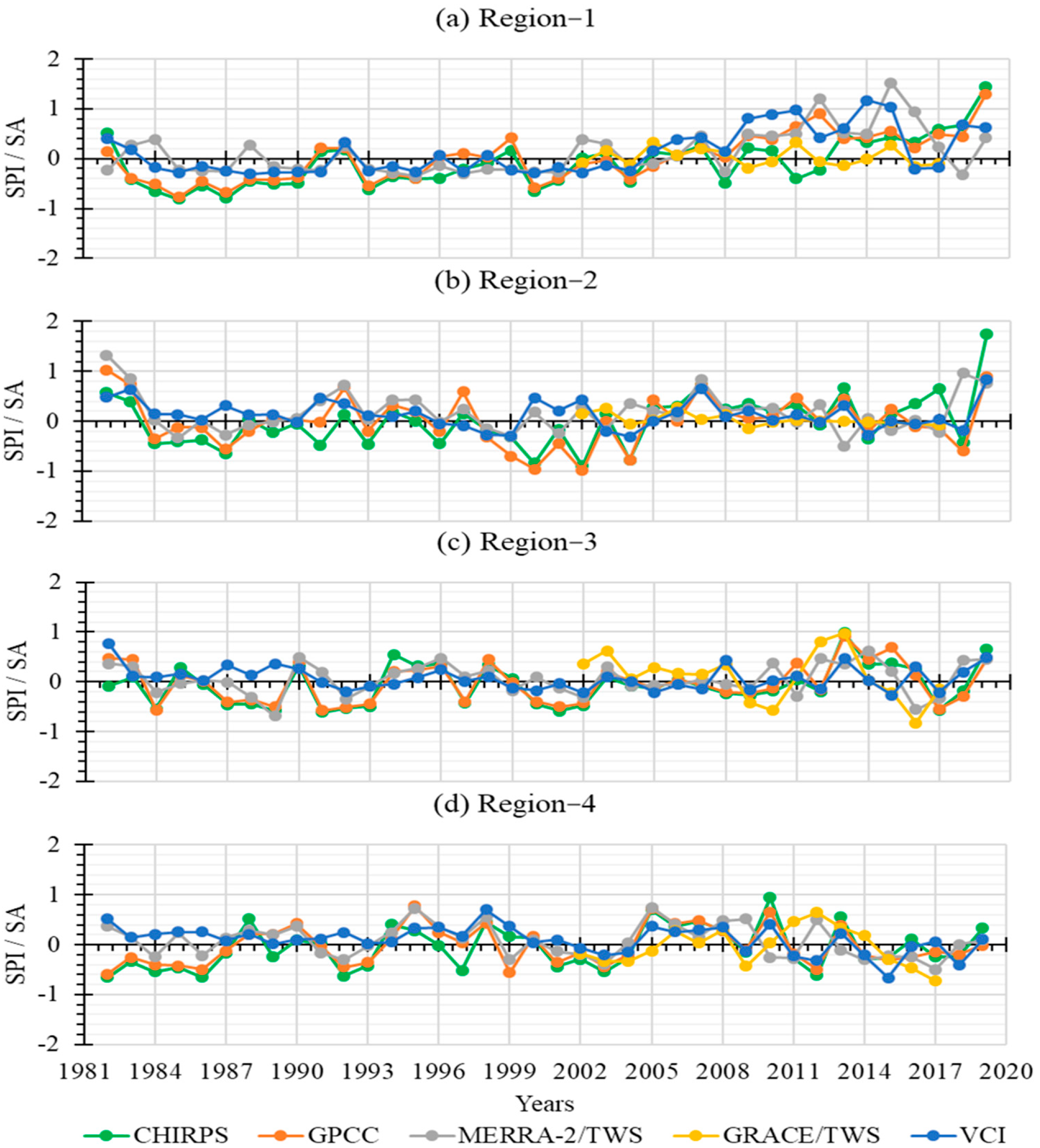


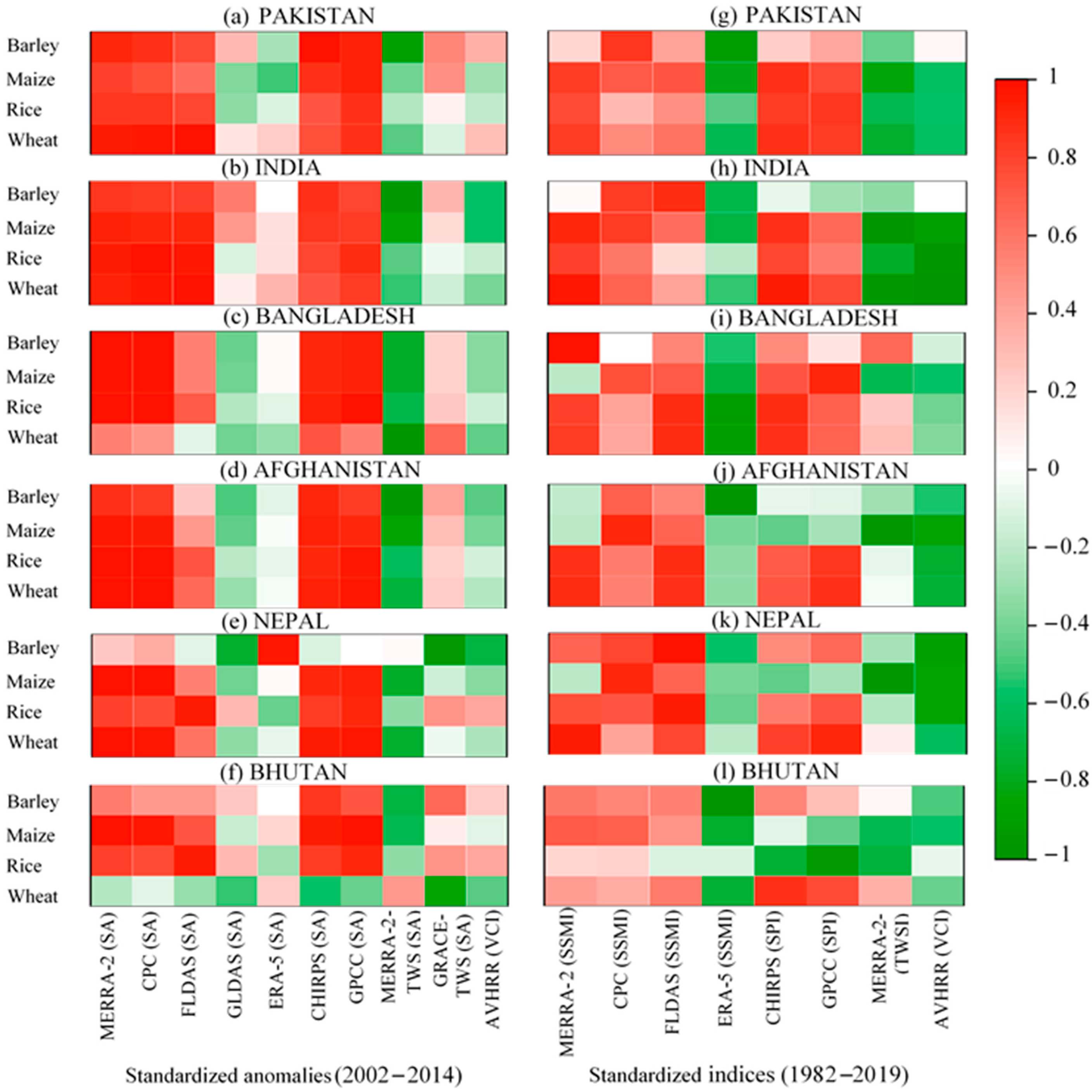
| Parameters | Products | Temporal Resolution | Spatial Resolution | Duration | Primary References |
|---|---|---|---|---|---|
| Precipitation | CHIRPS | Monthly | 0.05° × 0.05° | 1982–2019 | Funk et al., 2015; McNally et al., 2017, 2016; Shukla et al., 2014 [28,33,34,42]. |
| GPCC | Monthly | 0.5° × 0.5° | 1982–2019 | Agutu et al., 2017; Dutra et al., 2014; C. Funk et al., 2014; Kurnik et al., 2011 [12,50,51,52]. | |
| Soil moisture | FLDAS | Monthly | 0.1° × 0.1° | 1982–2019 | Agutu et al., 2017; Jung et al., 2020; McNally et al., 2017 [12,34,53]. |
| GLDAS | Monthly | 1° × 1° | 1982–2014 | Agutu et al., 2017; Chen et al., 2020; Jung et al., 2020 [12,53,54]. | |
| CPC | Monthly | 0.5° × 0.5° | 1982–2019 | Fan and van den Dool, 2004; Wu, 2014 [55,56]. | |
| MERRA-2 | Monthly | 0.625° × 0.5° | 1982–2019 | Chen et al., 2020, 2019; Le et al., 2020 [54,57,58]. | |
| ERA5 | Monthly | 1° × 1° | 1982–2019 | Almendra-Martín et al., 2021; Cheng et al., 2019 [38,59]. | |
| TWS | MERRA-2 | Monthly | 0.625° × 0.5° | 1982–2019 | Agutu et al., 2017; Bosilovich et al., 2015 [12,36]. |
| GRACE | Monthly | 1° × 1° | 2002–2017 | Fan and van den Dool, 2004; Heimhuber et al., 2019; Wu, 2014 [55,56,60]. | |
| VCI | NDVI | 15 days | 0.083° × 0.083° | 1982–2019 | Ali et al., 2019a; Bhuiyan et al., 2006; Karnieli et al., 2010; Wang et al., 2001 [20,48,61,62]. |
| Crop data | Barley, maize, wheat, and rice | Annual | National | 1982–2019 | http://www.fao.org/faostat/en/#data/QC (accessed on 20 February 2021). |
| SPI | Drought Categories |
|---|---|
| >1.65 | Extreme wetness |
| >1.28 | Severe wetness |
| >0.84 | Moderate wetness |
| >−0.84 and <0.84 | Average (normal) |
| <−0.84 | Moderate dryness |
| <−1.28 | Severe dryness |
| <−1.65 | Extreme dryness |
| Regions | Countries/Areas |
|---|---|
| Region 1 (northwest) | Afghanistan; northern, eastern, and central parts of Pakistan; Jammu and Kashmir, northern India |
| Region 2 (southwest) | Southern and southwestern Pakistan and western India |
| Region 3 (northeast) | Central and eastern India, Nepal, Bhutan, and Bangladesh |
| Region 4 (southeast) | Southern India and Sri Lanka |
| Region | MERRA-2 (SSMI) | CPC (SSMI) | FLDAS (SSMI) | GLDAS (SSMI) | ERA5 (SSMI) | CHIRPS (SPI) | GPCC (SPI) | MERRA-2 (TWSI) | GRACE (SA) | AVHRR (VCI) |
|---|---|---|---|---|---|---|---|---|---|---|
| 1 | 18.70 | 16.6 | 17.97 | 11.62 | 4.58 | 14.09 | 18.11 | 20.29 | 1.30 | 19.1 |
| 2 | 14.06 | 17.4 | 14.82 | 10.58 | 9.05 | 16.70 | 17.03 | 25.96 | 0.56 | 7.45 |
| 3 | 15.60 | 15.7 | 18.55 | 7.70 | 4.79 | 17.76 | 15.80 | 9.78 | 9.64 | 5.47 |
| 4 | 14.89 | 13.7 | 12.55 | 5.91 | 4.29 | 15.49 | 13.40 | 28.40 | 6.04 | 7.13 |
| Mean | 63.25 | 63.4 | 63.89 | 35.81 | 22.71 | 64.04 | 64.34 | 84.43 | 17.54 | 39.15 |
Publisher’s Note: MDPI stays neutral with regard to jurisdictional claims in published maps and institutional affiliations. |
© 2021 by the authors. Licensee MDPI, Basel, Switzerland. This article is an open access article distributed under the terms and conditions of the Creative Commons Attribution (CC BY) license (https://creativecommons.org/licenses/by/4.0/).
Share and Cite
Shahzaman, M.; Zhu, W.; Ullah, I.; Mustafa, F.; Bilal, M.; Ishfaq, S.; Nisar, S.; Arshad, M.; Iqbal, R.; Aslam, R.W. Comparison of Multi-Year Reanalysis, Models, and Satellite Remote Sensing Products for Agricultural Drought Monitoring over South Asian Countries. Remote Sens. 2021, 13, 3294. https://doi.org/10.3390/rs13163294
Shahzaman M, Zhu W, Ullah I, Mustafa F, Bilal M, Ishfaq S, Nisar S, Arshad M, Iqbal R, Aslam RW. Comparison of Multi-Year Reanalysis, Models, and Satellite Remote Sensing Products for Agricultural Drought Monitoring over South Asian Countries. Remote Sensing. 2021; 13(16):3294. https://doi.org/10.3390/rs13163294
Chicago/Turabian StyleShahzaman, Muhammad, Weijun Zhu, Irfan Ullah, Farhan Mustafa, Muhammad Bilal, Shazia Ishfaq, Shazia Nisar, Muhammad Arshad, Rashid Iqbal, and Rana Waqar Aslam. 2021. "Comparison of Multi-Year Reanalysis, Models, and Satellite Remote Sensing Products for Agricultural Drought Monitoring over South Asian Countries" Remote Sensing 13, no. 16: 3294. https://doi.org/10.3390/rs13163294
APA StyleShahzaman, M., Zhu, W., Ullah, I., Mustafa, F., Bilal, M., Ishfaq, S., Nisar, S., Arshad, M., Iqbal, R., & Aslam, R. W. (2021). Comparison of Multi-Year Reanalysis, Models, and Satellite Remote Sensing Products for Agricultural Drought Monitoring over South Asian Countries. Remote Sensing, 13(16), 3294. https://doi.org/10.3390/rs13163294


