1. Introduction
The study of the Earth at night has undergone major developments in the last decade or so due to the availability of detailed, quantitative nightly data from NASA’s SUOMI satellite, and now the NOAA-20 satellite. Data from the Visible Infrared Imaging Sensor suite (VIIRS) and, in particular, from the visible light Day-Night Band (DNB) instrument which provides quantitative radiances at the nW cm
−2 sr
−1 level to 500 m resolution has revolutionised studies of light pollution, energy use and the economy, as well as the effects of natural and human-made disasters in time and space-see, e.g., [
1] and references therein. However, the study of visible light at night is more complex than daytime sensing due to the range and complexity of the different angular emissions from light sources as well as from the effects of obstructions, coupled with subsequent scattering processes [
2]. For light pollution and total energy studies, we need to understand how light enters the environment from lit areas over a wide range of azimuth and elevation (or zenith distance): light at low angles to the horizon propagates into the surrounding countryside, while light escaping in the near-vertical direction propagates into space to be detected through aerial or space-based observations. In order to understand light pollution in toto, we therefore need to understand the so-called “emission function” describing the emission with respect to azimuth and zenith angle from the range of sources found in urban areas as well as their surrounding environment which both shields and scatters radiation. As noted by Solar Lamphar in his review of the emission function of light sources, this is one of the key properties required to characterise the artificial sky brightness and so underpins the work of modellers and affects a whole range of other users including planners, engineers and environmentalists as well as light pollution researchers and astronomers who depend on these results for practical applications [
3].
The interplay of the localised radiance and the measured sky luminance over a large area is mediated through the exact nature of the city emission function (CEF). There is a wide range of light sources in dense urban areas, ranging from public and commercial lighting to lit windows and car headlights, and the spectral nature of these sources is quite broad. Besides these source variations, the environment of this lighting also differs dramatically, affecting the amount and colour of the light propagating into the environment, with variations of many orders of magnitude occurring over sub-metre scales due to spatial variations in illumination and obstructions. Hence, to understand the details of how light is emitted from urban areas, the 3D nature of the surface must be taken into account in order to understand the angular emission [
3]. Because of these complexities, modelling of the overall output has tended to be split between relatively simple functional forms which are symmetric in azimuth and generalised over a relatively wide urban area, e.g., [
4,
5,
6], and more complex models which require extensive computer time but which capture more physics of the scattering and radiative transfer and include spectral dependence, driven by the spread of white LED lighting, e.g., [
7] and [
8]. Two major steps forward in the analysis of observations in recent years have come through the use of inversion techniques to determine the emission function from all-sky camera measurements and the quantification of radiance with angle from SUOMI VIIRS DNB data. With these approaches we now have the means to check models for individual towns and city subunits and verify the colour-dependent emission function for the case of the camera data. Understanding of the underlying CEF is also required if we are to unwind the effects of aerosol scattering over those areas [
2].
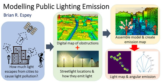
In this paper, we outline how to generate the urban emission functions for public lighting in as realistic an environment as possible incorporating real-world photometry and obstructions. Although there is currently much discussion on the relative importance of public lighting compared with other sources, including retail, commercial, and domestic, public lighting is certainly of major importance for smaller Irish towns without extensive infrastructure, and also accounts for approximately half of the emission in denser urban areas based on our own studies. For other countries and lighting practices, public lighting can be smaller, particularly where lanterns have better lighting control, e.g., [
9].
Practical advantages to basing studies on public lighting—at least initially—is the more ready availability of centralised information and also the standardisation of the lantern types and, hence, photometry, i.e., the radiance with light emission direction. The aforementioned importance of public lighting for towns in rural areas with low surrounding emission facilitates the space measurement of light output and its angular variation with zenith distance. For these reasons we use public lighting as the basis of the work presented here, with the goal to determine the azimuthal and altitude—or, equivalently zenith distance—dependence. An additional goal was to generate the model as efficiently as possible, making use of existing Geographical Information System (GIS) tools as these are optimised to handle large 2D and 3D datasets. We have focused on the use of shareware as source code is available for scrutiny and the packages are available to run on a range of devices from desktops to laptops.
Note that our initial work is focused on determining emission functions, i.e., the radiance or intensity with angle, in real-world cases where public lighting dominates for a range of different, but representative, environments. Additionally, we seek to compare our results with those produced by inversion techniques as well as direct observation using aerial or satellite observation for the case where scattering is small. Our work is not intended to supplant modelling incorporating atmospheric scattering, etc., for which sophisticated modelling codes already exist, but to provide insight as well as representative urban emission functions which can be used in future work.
2. Data and Methods
Our approach makes use of the similarity of public lighting over regions, e.g., similar makes, wattages and installation height of lanterns along a street to simplify the computational problem and uses Geographical Information System (GIS) tools to capture information on placement of lighting and obstructions in a three dimensional space. For our modelling of public light emission, we make use of the following three datasets: (1) a three-dimensional map or digital surface model (DSM) of the study area with height information recorded for each pixel; (2) a public lighting database recording streetlight locations to one metre accuracy, as well as lamp types and wattages; (3) the manufacturer’s lighting photometry for each type of lantern.
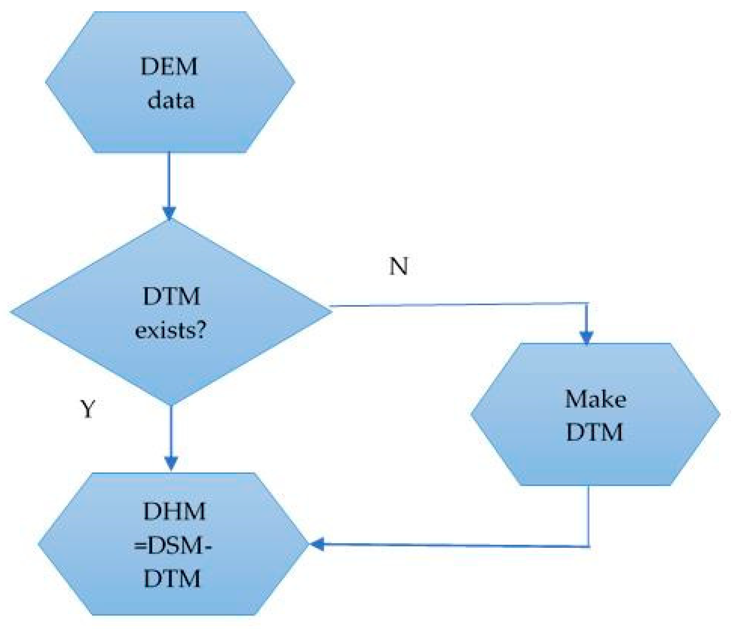
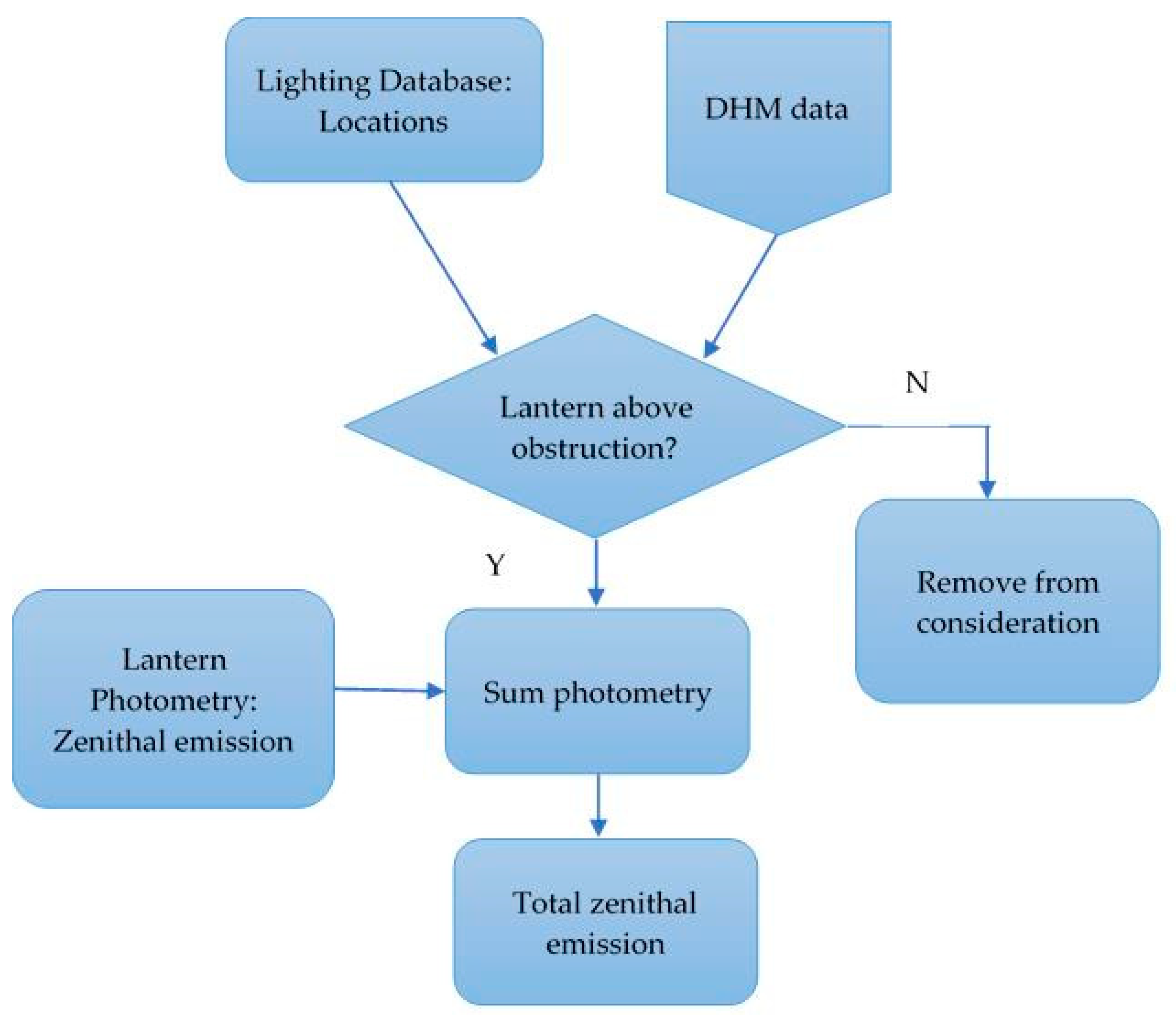
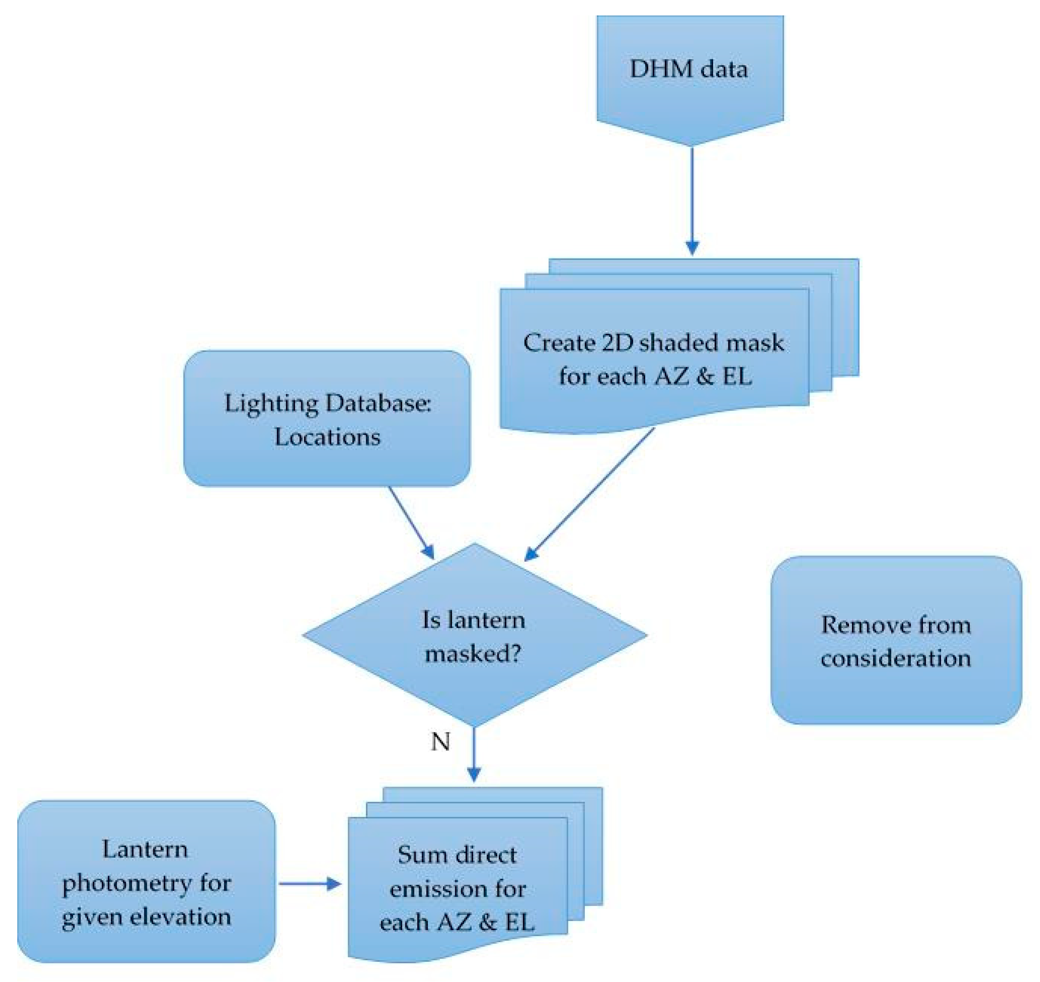
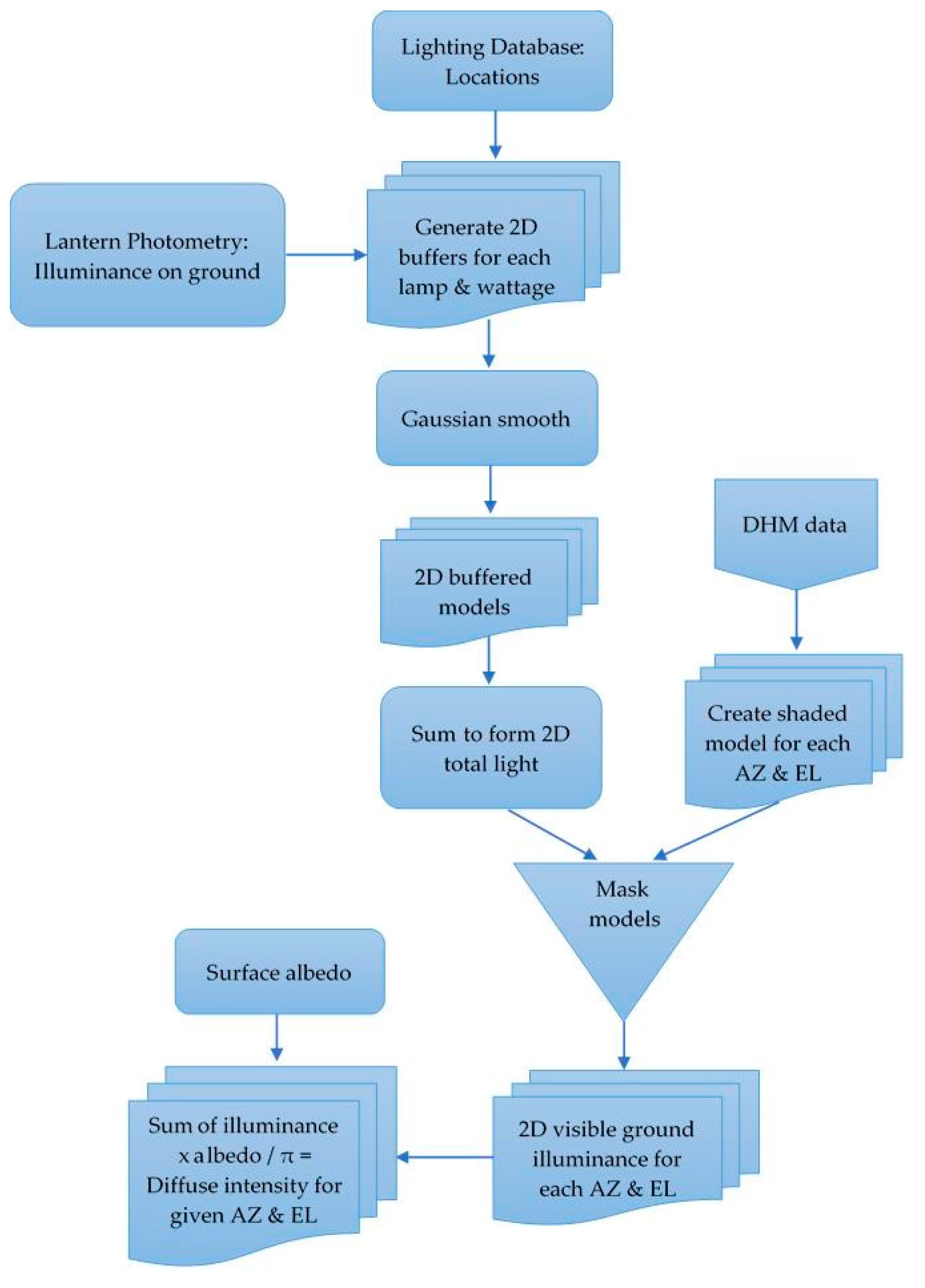
An overview of the processing steps is presented in the form of workflow diagrams in
Appendix A. We will discuss each component in turn including describing some of the results for the smallest and largest areas. For reference an outline of the processes is provided in the form of flowcharts in the
Appendix A.
2.1. Digital Mapping Data
Digital surface map (DSM) data consists of three dimensional files containing height measurements for all structures, e.g., buildings and trees, measured relative to a height datum for a matrix of geographical locations. These data are taken from an aircraft or drone and may be produced using laser altimetry or stereo photogrammetry. For the three dimensional maps used here we used Light Detection and Ranging (LiDAR) data which are freely available. The availability of high-resolution data determined our choice of study areas from which we chose a set of eight rural towns in County Cork and an urban test area in Dublin. For the rural data, the towns range in population from hamlets of a few people to towns with a population of just over one thousand and all sampled locations typically cover a square kilometre or so. In the case of the rural towns, spot checking showed that typical streets were 8 m in width and buildings were mainly two storey, with peak roof heights of lower than 10 m. The Dublin test area covered an area of approximately 1.5 km
2 close to the Grafton Street shopping district and lying approximately a kilometre from the City Centre. This area encompasses a range of street types from relatively open tree-lined Georgian squares with street widths of 20–30 m to smaller side streets with typical widths of approximately 10 m. There are 2100 buildings within the area, with a mean building height of 12 m. Note, however, that this value is averaged over all building types and does not capture the relatively broad range of structure types as well as in widths and heights, as shown in
Figure 1.
The LiDAR data were obtained in 2015 and are publicly available at the
data.gov.ie website under a Creative Commons (CC BY 4.0) licence (last accessed 19 September 2021). There are a few noticeable changes in the Dublin data due to construction work, but the vast majority of the buildings are the same as those today. while the Dublin data were obtained in March 2015 when trees were in leaf. The data are stored as raster (TIFF) images with a ground sampling distance (GSD) of 1 m and the largest area included had a file size of 16 MB. The datasets come from two different sources: the Cork county data came from a Geological Survey of Ireland campaign in November and December 2015 with a rms vertical accuracy of 15 cm, while the Dublin data came from a high-resolution survey conducted by University College Dublin’s Urban Modelling Group conducted in March 2015 which has a vertical rms accuracy of 30 mm. The raster image data can be easily and efficiently handled in GIS software and, due to the increasing use of such data for insolation and urban heating analysis as well as general topographic mapping, a number of tools and packages have been developed which efficiently handle these datasets. We have chosen to use a combination of QGIS [
10] and R software [
11] tools for processing based on our familiarity with the packages, though other software packages may also be suitable if offering similar functionality.
2.2. Streetlight Information
Lighting databases are not publicly available for the areas used in this study, but for the mapping of the streetlighting data, we obtained databases by directly request to the lighting authorities in Dublin City Council and the Road Management Office in Cork. The lighting data are representative of the situation in 2016 and 2017 for the Dublin and Cork County data, respectively, so broadly similar to the date of the elevation data. These files contain information on pole location, lantern height, lamp type and wattage. In all locations, as elsewhere in Ireland, the lighting stock is dominated by low and high pressure sodium lighting of a few major lantern types. We confirmed the make and model of the lanterns through the use of Google Street View imagery and on-line reference databases of lantern imagery [
12,
13,
14]. Using this information, we then accessed the manufacturer’s photometry for the luminaires to determine the azimuthally-averaged emission to the sky for different elevations and also modelled the light falling on the road surface by using a commercial lighting design software [
15]. No allowance was made for aging of the lamps and/or degradation of the optics, i.e., a maintenance factor of 1.0 was adopted in all cases. The main lamp types were low and high pressure sodium types (LPS and HPS, respectively), with the lumen-weighted proportion of LPS lanterns ranging from 83% for the smallest hamlet with five houses to 0.8% for the Dublin area. The total number of lights in each location ranged from nine to over one thousand for the Dublin test area. Example data for two lantern types commonly used in smaller towns are shown in
Table 1 below.
Photometry
Although manufacturer data were not included in the lighting databases, a relatively small number of lanterns of mainly low and high pressure sodium types are used and we used Google Street View to identify the models. With this information in hand, we accessed the appropriate lighting manufacturer photometry files from the data packaged with the 2019 Lighting Reality streetlighting design software [
15]. In our case, the files contained data for the angle-dependent luminous intensity values historical LPS and HPS lanterns, though similar data may be available on-line for lanterns used in other jurisdictions.
To avoid the need to keep detailed accounting of emission angles, we simplify the lantern emission by assuming an azimuthally uniform emission equal to the mean of the light emitted in the forward direction, i.e., across the road (90° < C < 270° in terms of the lantern C-Gamma co-ordinates used in such photometry). We take this approach as emission towards the road side is more likely to escape to the sky and use the mean value to simplify the processing for this initial approach. Data for nearly four dozen different lanterns, including both road and decorative lights, covering ten different elevation (γ) directions for each are included in the current database.
5. Conclusions
In his 2018 paper entitled “Towards a comprehensive city emission function”, Kocifaj noted that it was impossible “to predict the cumulative light emission from all structures in a heterogeneous light-emitting or blocking environment, embracing topography, luminous building facades, street lighting, advertising displays and other luminous or blocking constructs” [
22]. In this paper, we have presented a new and efficient method for modelling light and obstructions which makes use of three dimensional data of urban areas including the effect of natural as well as artificial obstructions down to the one metre scale. We believe that the approach in this paper provides an efficient way to tackle the problem discussed by Kocifaj and to generate a range of CEFs which can be used as input to more detailed propagation codes. Our approach can also be expended to deal with additional detail such as luminous vertical surfaces such as facades, shop windows, etc.
In our work, we have used publicly available LiDAR data to produce a computationally efficient high-resolution model of a range of real-world built environments which can be extended to larger areas. Some information regarding the availability of both LiDAR and public lighting information for other areas is provided in
Appendix A.3. Due to the decrease in hardware prices, another approach could be taken using drones to provide high-resolution LiDAR or photogrammetry data for regions where no such material exists currently. We have shown that there can be considerable variation in building sizes, heights and spacings across a relatively small area, particularly as shown in the Dublin data where large (wooded) green squares are present as well as a range of streets ranging from narrow ones with lower wattage lighting on shorter poles, to broader streets with higher mounted and more powerful lights. The modelled emission can thus vary quite strongly over a relatively small area, and simple averaging of the properties does not capture the finer detail. It is this detail which gives rise to the asymmetries in angular emission seen from above and hence we believe that, suitably developed, our approach shows promise for the future in terms of developing representative CEF models which can be used as input for radiative transfer codes. Our work can also be extended to a simple spectral-dependent model since our datasets are already broken down by lamp type. In city areas, there is a difference in the light sources used in the inner city (mainly whiter forms) and those in the suburbs (older LPS and HPS lighting which is slowly being replaced with LED types). Since there is also a difference in terms of building size and green spaces between these two areas, there may be significant differences in both colour and CEF between different parts of the same city.
The inclusion of additional sources of light including lit vertical surfaces is also being considered and may be possible by incorporating the highly detailed LiDAR point cloud data for Dublin which has up to 348 points per square metre. These data have been categorised to produce datasets describing the reflecting surface, e.g. opaque walls and windows and can also distinguish between roads, paths and grass areas, thus also permitting a variable albedo to be applied [
24].
Since completion of this work, we now have a more extensive range of DSM data based on photogrammetric measurements at similar resolution to that presented here. In addition, datasets at both 0.5 m and 2 m GSD are available and we intend to study these data to extend this work and also determine whether results are sensitive to the resolution of the mapping dataset. One immediate goal is to examine the range of CEFs for different urban areas and land use types, and to determine whether a parameterisation of the CEF data by landuse is possible. The existence of data taken at different seasons also raises the possibility of studying the effects of blocking by foliage which has been estimated to cause a 31% reduction in light towards the sky [
25]. On a longer timescale, other enhancements which can be implemented include more accurate positioning of the lanterns by locating them at the end of the installation arms (which may be up to 1.6 m long) rather than at the location of the lighting poles, as well as the use of explicit angle-dependent photometry in the azimuthal (C-direction) rather than averaged data.
Finally, of relevance to the Irish environmental light situation, and possibly more globally, our results show that smaller Irish towns with their relative openness and older lighting with a larger upward light ratio may produce a larger environmental impact for their size than might be expected from larger towns and cities. If lights from shop signage, petrol stations and parking areas are included, this may make their impact even higher. Comparison of the lighting impact of smaller towns with that of brightly lit areas such as shopping centres, industrial areas and ports—which generally lie on the outskirts of cities in more open areas—will be of importance in understanding the interplay of light pollution sources. Using such information can guide the development of planning restrictions as well as in determining whether a universal emission function parameterisation can be derived.
